Controlled-source electromagnetic imaging of the Middle America Trench o"shore Nicaragua
|
|
|
- Dwight Stanley
- 5 years ago
- Views:
Transcription

, Steven Constable (SIO),")
1 Controlled-source electromagnetic imaging of the Middle America Trench o"shore Nicaragua Kerry Key Scripps Institution of Oceanography Collaborators: Samer Naif (SIO, now LDEO), Steven Constable (SIO), Rob L Evans (WHOI)


2 Central America tectonic setting 20º N Middle America Trench 15º N EPR 58 mm/yr Nicaragua 72 mm/yr 10º N Cocosos 83 mm/yr Cocos Ridge 5º N Pacific CNS 0º N Nazca 105º W 100º W 95º W 90º W 85º W


3 Plate bending EPR 58 mm/yr Nicaragua reactivated! normal faults 72 mm/yr Cocosos Middle America Trench 83 mm/yr Cocos Ridge Pacific CNS Nazca plate motion trench
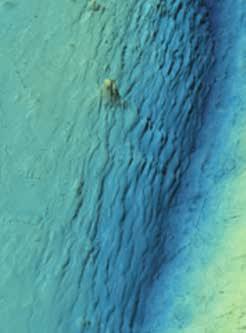
![Nicaragua s bending faults a) Grevemeyer et al. (2005) Heat flow [mw m -2 ] 35 30 25 20 15 10 5 Ranero et al.](/docs-images/89/98636392/images/4-1.jpg "(2003) b) # Faults 10 8 6 4 2 0 30 25 20 15 10 5 Distance from trench [km] Mantle penetrating normal faults observed at the Nicaragua outer rise Density of faults correlates with decreasing")
4 Nicaragua s bending faults a) Grevemeyer et al. (2005) Heat flow [mw m -2 ] Ranero et al. (2003) b) # Faults Distance from trench [km] Mantle penetrating normal faults observed at the Nicaragua outer rise Density of faults correlates with decreasing (unusually low) heat flow Suggests faults are porous pathways for fluid transport, fueling hydrothermal circulation, hence hydrothermal alteration However, no published evidence shows faults are pathways Cumulative fault offset [m]

5 Geosystems G Motivation Ranero et al. (2005) Figure 13. Cartoon showing a conceptual model of the structure and metamorphic evolution of subducting lithosphere # Mantle formed penetrating a fast spreading normal center. faults The could topography provide of the fluid plate pathway in the outer-rise/trench for serpentinization region has been exaggerated # Subducted to showhydrous better the deformation minerals become associated to unstable plate bending. at high Scalepressure/temperature, is approximate everywhere else. Fault plane solutions of earthquakes are projected into the top of the slab and the plane of the cross section. Black filled circles leading in oceanic to crust dehydration indicate hydration. reactions See section that release 6 for discussion free water of model. # Water promotes melting and is critical driver of arc volcanism # Water weakens the plate interface, modulates megathrust seismicity

6 Electrical resistivity of oceanic plates Resistivity ρ (ohm-m) ,000 10,000 water porous sediments seawater fresh water basalt Dependent on porosity gabbro cold mantle serpentinite depends on magnetite basaltic melt pure melt partial melt Conductivity σ (S/m) inversion models use same colorbar
7 Controlled Source Electromagnetic Method ocean (conductive) sediments (conductive) oil or gas reservoir (resistive) 3D Vector Diffusion Equation: Frequency Range: Hz Resistors Conductors Attenuation: Low High Phase Velocity: Fast Slow

8

9 EM Receiver Deployment Movie:

10 CSEM Transmitter Deployment Movie:
 receiver deployments 800 km of CSEM tows 96% data recovery")
11 The Serpentinite, Extension and Regional Porosity Experiment Across the Nicaraguan Trench (SERPENT) First CSEM survey of a subduction zone Single 28 day cruise produced 54 broadband MT / EM stations 4 long-wire EM (LEM) receiver deployments 800 km of CSEM tows 96% data recovery rate


, Electromagnetic detection of")
12 Results from Anisotropy Circles # Polarization ellipse maxima show anisotropic fabric aligned with faults # Anisotropy significantly stronger beneath the outer rise! Data well fit with fault parallel conductive plates, 5:1 anisotropy Key, K., S. Constable, T. Matsuno, R. L. Evans, and D. Myer (2012), Electromagnetic detection of plate hydration due to bending faults at the Middle America Trench, Earth Planet Sc Lett, ,
13 CSEM Data Examples Abyssal Plain a Amplitdue ( V/Am 2 ) Hz 0.75 Hz 1.75 Hz Abyssal Plain site s08 (100 km) Phase (degrees) flat phase = highly resistive b southwest northeast Tx-Rx Range (km) Tx-Rx Range (km) Outer Rise Amplitdue ( V/Am 2 ) Hz 0.75 Hz 1.75 Hz faults Outer Rise site s27 (20 km) Phase (degrees) Tx-Rx Range (km) Tx-Rx Range (km) decreasing phase = less resistive crust faults
 tectonic plate motion 4 8 outer rise 8 4 Depth below seasurface (km)")
 # 32,500 data # 28,000 model parameters #")

14 CSEM Inversion Model North EM receivers fluid seeps seafloor depth (km) tectonic plate motion 4 8 outer rise 8 4 Depth below seasurface (km) Distance from trench (km) Resistivity (Ω-m) # 32,500 data # 28,000 model parameters # Regularized non-linear inversion with adaptive finite element forward solver # Fit to RMS 1.0 with 2% error floor # Ran on 320 processors for 16 hours


,")

15 Outer rise fault scarps conductive faults # Dashed lines: P-wave velocity anomalies from Ivandic et al. (2008) # Fault scarps correlate with steeply dipping conductive channels # Porous channels along the fault traces drive fluids into the slab # Mantle stays resistive Naif, S., K. Key, S. Constable, and R. L. Evans (2015), Water-rich bending faults at the Middle America Trench, Geochem Geophy Geosy, 16(8),
 25 15 10 7 4 3 2 1.5 1 0.7 0.")
16 Porosity Estimated from Resistivity 2.5 VE 7.5:1 Depth (km) Moho Distance from trench (km) Porosity (%) Archie s Law: bulk resistivity fluid resistivity porosity cementation exponent m = 2.0
17 Porosity Evolution with Plate Bending Distance from trench Extrusives, m= 2 Dikes, m= 2 Gabbros, m= 2 24 Ma crust* km km km * from Jarrard's (2003) ocean drilling compilation study Crustal porosity increases 60%, doubles in the lower crust Significantly more crustal pore water is subducted than previously thought


18 Seismic evidence for uppermost mantle serpentinization van Avendonk et al (2011)
19 Outer Rise Summary: Bending faults are porous fluid pathways More pore water subducts than previously thought Crust is heterogeneously hydrated Mantle remains resistive seismic data requires significant serpentinization high resistive compatible with low magnetite content, implies low degree of serpentinization (<15%)


20 CSEM Inversion Model EM receivers fluid seeps North seafloor depth (km) tectonic plate motion 4 8 forearc 8 4 Depth below seasurface (km) Distance from trench (km) Resistivity (Ω-m)
21 Forearc Resistivity 10 0 Resistivity (Ωm) i. Sediment subduction along megathrust plate interface Depth (km) i ii iii plate interface ii. Resistive upper plate is low porosity, consistent with basement rock iii.conductor penetrates upper plate Distance from trench (km) 35
22 Sediment Subduction Accreting Margin: thicker sediments on incoming plate most sediments accreted onto margin compacted deeper sediments subducted less water subducted Le Pichon et al. (1993) Non-accreting Margin: thinner sediments on incoming plate all sediments subducted sediments have higher porosity more water subducted Nicaragua is non-accreting
23 Depth (km) Subducted sediment porosity # Porosity estimated with an empirical relationship that accounts for surface conduction in clays (Sen & Goode, 1998) estimated compaction model 35 # Compaction model from lab studies and drilling data: Porosity φ m=2.6 Q v =0.3 (Spinelli et al., 2006; Bray & Karig, 1985) m=2 Q v = Distance from trench (km)

 #")


24 Additional fluids from clay transformation Sa"er and Tobin (2011) # Example for Nankai Trough # Compaction is largest source of fluids in first 20 km # Clay transformation is largest source of fluids beyond 20 km


25 Abundant seeps km from trench axis SERPENT CSEM Sahling et al (2008) Ranero et al. (2008)


26 Conceptual model of shallow forearc fluid processes Ranero et al. (2008)
27 Conductor above plate interface: porous pathway for fluid transport? 10 0 Resistivity (Ωm) fluid seeps 3 Depth (km) plate interface Distance from trench (km) 35


 3 4 5 #")


28 Conductor above plate interface - what is it? 10 0 Resistivity (Ωm) fluid seeps # Underthrust sediments? $ uplift Depth (km) # Subducted seamount? $ no evidence in bathymetry not well constrained # Locus of persistent hydrofracturing? $ subsidence Distance from trench (km) 35 How localized is this feature along axis?


29 McIntosh et al. (2007) 10 0 Resistivity (Ωm) Depth (km) Distance from trench (km) 35

30 Conclusions 1. Outer rise faults are porous fluid pathways! Water-rich heterogeneously hydrated crust 2. Incoming fluid-rich sediment layer fully subducted! First estimate of in-situ subducted sediment porosity! Seeps fed by subducted sediment fluids
PUBLICATIONS. Geochemistry, Geophysics, Geosystems. Water-rich bending faults at the Middle America Trench RESEARCH ARTICLE 10.
 PUBLICATIONS Geochemistry, Geophysics, Geosystems RESEARCH ARTICLE Key Points: Fluids penetrate the crust at the outer rise Bending faults double porosity of the lower crust Significantly more pore water
Geophysical Constraints on Incoming Plate Hydration
 Geophysical Constraints on Incoming Plate Hydration Douglas A. Wiens Dept. of Earth and Planetary Sciences Washington University, St. Louis, MO, USA Subduction Cycles the Incoming Plate Subduction Input
A seismic refraction study of the Cocos plate offshore Nicaragua and Costa Rica Harm Van Avendonk (UTIG, UT Austin)
") A seismic refraction study of the Cocos plate offshore Nicaragua and Costa Rica Harm Van Avendonk (UTIG, UT Austin)! October 18, 2012 "#$%&'($)*!+,!-&./(!01!2/(+! Plate tectonics:!!large fluxes of solids
A seismic refraction study of the Cocos plate offshore Nicaragua and Costa Rica Harm Van Avendonk (UTIG, UT Austin)! October 18, 2012 "#$%&'($)*!+,!-&./(!01!2/(+! Plate tectonics:!!large fluxes of solids
Earth and Planetary Science Letters
 Earth and Planetary Science Letters 351 352 (212) 45 53 Contents lists available at SciVerse ScienceDirect Earth and Planetary Science Letters journal homepage: www.elsevier.com/locate/epsl Electromagnetic
The influence of short wavelength variations in viscosity on subduction dynamics
 1 Introduction Deformation within the earth, driven by mantle convection due primarily to cooling and subduction of oceanic lithosphere, is expressed at every length scale in various geophysical observations.
Collaborative Research: SERPENT: Serpentinite, Extension, and Regional Porosity Experiment across the Nicaraguan Trench
 Collaborative Research: SERPENT: Serpentinite, Extension, and Regional Porosity Experiment across the Nicaraguan Trench Intellectual Merit Water plays an important role in the volcanic processes occurring
Plate Tectonics on a Plane. Observations related to plate tectonics " " Plate tectonic theory types of plate boundaries!
 Plate Tectonics on a Plane Scripps Inst. Of Oceanography" Observations related to plate tectonics " Ocean and continent topography, hypsometry, and crustal thickness. Global seismicity, Benioff zones,
Lecture 24: Convergent boundaries November 22, 2006
 Lecture 24: Convergent boundaries November 22, 2006 Convergent boundaries are characterized by consumption of oceaninc crust in subduction zones, with attendant arc volcanism, metamorphism and uplift.
Earthquakes. Earthquakes are caused by a sudden release of energy
 Earthquakes Earthquakes are caused by a sudden release of energy The amount of energy released determines the magnitude of the earthquake Seismic waves carry the energy away from its origin Fig. 18.1 Origin
Plate Tectonics. entirely rock both and rock
 Plate Tectonics I. Tectonics A. Tectonic Forces are forces generated from within Earth causing rock to become. B. 1. The study of the origin and arrangement of Earth surface including mountain belts, continents,
Earth s Continents and Seafloors. GEOL100 Physical Geology Ray Rector - Instructor
 Earth s Continents and Seafloors GEOL100 Physical Geology Ray Rector - Instructor OCEAN BASINS and CONTINENTAL PLATFORMS Key Concepts I. Earth s rocky surface covered by of two types of crust Dense, thin,
Marine Science and Oceanography
 Marine Science and Oceanography Marine geology- study of the ocean floor Physical oceanography- study of waves, currents, and tides Marine biology study of nature and distribution of marine organisms Chemical
Backarc basin Spreading axis* Magmatic front. Convecting asthenosphere. Distance from trench (km)
") Backarc basin preading axis M agmatic arc Magmatic front basin Accretionary prism Outer trench high Depth (km) 0 50 00 50 400 Arc crust Lithospheric mantle Indicates feature that may or may not be present
Backarc basin preading axis M agmatic arc Magmatic front basin Accretionary prism Outer trench high Depth (km) 0 50 00 50 400 Arc crust Lithospheric mantle Indicates feature that may or may not be present
DEEP SAN ANDREAS FAULT BOUNDARY STRUCTURE FROM MARINE MAGNETOTELLURICS A
 DEEP SAN ANDREAS FAULT BOUNDARY STRUCTURE FROM MARINE MAGNETOTELLURICS A proposal submitted to UC Shipfunds for New Horizon and Sproul shiptime Brent Wheelock Kerry Key and Steven Constable SUMMARY Knowledge
Captain s Tryouts 2017
 Captain s Tryouts 2017 Dynamic Planet Test Written by: Araneesh Pratap (Chattahoochee High School) Name: Date: Answer all questions on the answer sheet. Point values are given next to each question or
L.O: THE CRUST USE REFERENCE TABLE PAGE 10
 USE REFERENCE TABLE PAGE 10 1. The oceanic crust is thought to be composed mainly of A) granite B) sandstone C) basalt D) rhyolite 2. To get sample material from the mantle, drilling will be done through
Along-strike variations in underthrust sediment dewatering on the Nicoya margin, Costa Rica related to the updip limit of seismicity
 GEOPHYSICAL RESEARCH LETTERS, VOL. 31, L04613, doi:10.1029/2003gl018863, 2004 Along-strike variations in underthrust sediment dewatering on the Nicoya margin, Costa Rica related to the updip limit of seismicity
Origin and Evolution of the Ocean Floor
 Origin and Evolution of the Ocean Floor Outline Mapping the Ocean Floor Continental Margins Origin of Oceanic Lithosphere Structure of Ocean Crust Mapping the ocean floor Depth originally measured by lowering
10. Paleomagnetism and Polar Wandering Curves.
 Map of ocean floor Evidence in Support of the Theory of Plate Tectonics 10. Paleomagnetism and Polar Wandering Curves. The Earth's magnetic field behaves as if there were a bar magnet in the center of
overlie the seismogenic zone offshore Costa Rica, making the margin particularly well suited for combined land and ocean geophysical studies (Figure
 Chapter 1 Introduction Historically, highly destructive large magnitude (M w >7.0) underthrusting earthquakes nucleate along the shallow segment of subduction zone megathrust fault, and this region of
Why Does Oceanic Crust Sink Beneath Continental Crust At Convergent Boundaries
 Why Does Oceanic Crust Sink Beneath Continental Crust At Convergent Boundaries What is the process by which oceanic crust sinks beneath a deep-ocean Why does oceanic crust sink beneath continental crust
Ocean Basins, Bathymetry and Sea Levels
 Ocean Basins, Bathymetry and Sea Levels Chapter 4 Please read chapter 5: sediments for next class and start chapter 6 on seawater for Thursday Basic concepts in Chapter 4 Bathymetry the measurement of
What Forces Drive Plate Tectonics?
 What Forces Drive Plate Tectonics? The tectonic plates are moving, but with varying rates and directions. What hypotheses have been proposed to explain the plate motion? Convection Cells in the Mantle
A) B) C) D) 4. Which diagram below best represents the pattern of magnetic orientation in the seafloor on the west (left) side of the ocean ridge?
 B) C) D) 4. Which diagram below best represents the pattern of magnetic orientation in the seafloor on the west (left) side of the ocean ridge?") 1. Crustal formation, which may cause the widening of an ocean, is most likely occurring at the boundary between the A) African Plate and the Eurasian Plate B) Pacific Plate and the Philippine Plate C)
1. Crustal formation, which may cause the widening of an ocean, is most likely occurring at the boundary between the A) African Plate and the Eurasian Plate B) Pacific Plate and the Philippine Plate C)
Whole Earth Structure and Plate Tectonics
 Whole Earth Structure and Plate Tectonics Processes in Structural Geology & Tectonics Ben van der Pluijm WW Norton+Authors, unless noted otherwise 4/5/2017 14:45 We Discuss Whole Earth Structure and Plate
Divergent Boundaries: Origin and Evolution of the Ocean Floor Earth - Chapter 13 Stan Hatfield Southwestern Illinois College
 Divergent Boundaries: Origin and Evolution of the Ocean Floor Earth - Chapter 13 Stan Hatfield Southwestern Illinois College Mapping the Ocean Floor Depth was originally measured by lowering weighted lines
Inaugural UK Broadband OBS Experiments Nicholas Harmon-University of Southampton, UK
 Inaugural UK Broadband OBS Experiments Nicholas Harmon-University of Southampton, UK VOILA Volatile recycling In the Lesser Antilles arc PILAB/EuroLAB Passive Imaging of the Lithosphere Asthenosphere Boundary
Subduction zones 3 arc magmatism
 5. 3 Subduction zones 3 arc magmatism Where can we observe magmatic/volcanic activities along subduction zones? Characteristics of arc magmatism (vs. mid-ocean ridge/intraplate magmatism) Structure of
The Ocean Floor Earth Science, 13e Chapter 13
 The Ocean Floor Earth Science, 13e Chapter 13 Stanley C. Hatfield Southwestern Illinois College The vast world ocean Earth is often referred to as the blue planet Seventy-one percent of Earth s surface
Plate Tectonics. By Destiny, Jarrek, Kaidence, and Autumn
 Plate Tectonics By Destiny, Jarrek, Kaidence, and Autumn .The Denali Fault and San Andreas Fault - The San Andreas Fault is a continental transform fault that extends roughly 1300 km (810 miles) through
Subduction zones are complex plate boundaries in which variable geometry and structure can be
 1 Chapter 1 Introduction Subduction zones are complex plate boundaries in which variable geometry and structure can be seismically observed. The along-strike transition from flat to normal subduction is
Introduction to Oceanography. Chapter 2: Plate Tectonics Overview
 Introduction to Oceanography Chapter 2: Plate Tectonics Overview Much evidence supports plate tectonics theory. The plate tectonics model describes features and processes on Earth. Plate tectonic science
Introduction to Oceanography
 Introduction to Oceanography Lecture 7: Plate Tectonics 3 Landers earthquake fault scarp, California, Photo by G. Peltzer (UCLA/JPL/NASA), courtesy JPL, http://www-radar.jpl.nasa.gov/sect323/insar4crust/landers_co_fig1.jpg
Beneath our Feet: The 4 Layers of the Earty by Kelly Hashway
 Beneath our Feet: The 4 Layers of the Earty by Kelly Hashway The Earth is more than a giant ball made up of dirt, rocks, and minerals. The Earth may look like a giant ball from when looking at it from
Announcements. Manganese nodule distribution
 Announcements Lithospheric plates not as brittle as previously thought ESCI 322 Meet in Env. Studies Bldg Rm 60 at 1 PM on Tuesday One week (Thursday): Quiz on Booth 1994 and discussion. (Lots of odd terms
ANOTHER MEXICAN EARTHQUAKE! Magnitude 7.1, Tuesday Sept. 19, 2017
 ANOTHER MEXICAN EARTHQUAKE! Magnitude 7.1, Tuesday Sept. 19, 2017 Why is there no oceanic crust older than 200 million years? SUBDUCTION If new oceanic crust is being continuously created along the earth
Earth. Temp. increases with depth, the thermal gradient is 25 o C/km. Pressure and density also increase with depth.
 Plate Tectonics Earth Earth overall average density = 5.5 g/cm 3. Temp. increases with depth, the thermal gradient is 25 o C/km. Pressure and density also increase with depth. Spheroid: with a longer major
Seafloor Morphology. Techniques of Investigation. Bathymetry and Sediment Studies
 Seafloor Morphology I f we select a grid for the surface of the earth (i.e. 5 km 2 ) and assign it an average elevation in relation to sea level, we can construct a graph of elevation versus area of the
The continental lithosphere
 Simplicity to complexity: The continental lithosphere Reading: Fowler p350-377 Sampling techniques Seismic refraction Bulk crustal properties, thickness velocity profiles Seismic reflection To image specific
Plate Tectonics. Structure of the Earth
 Plate Tectonics Structure of the Earth The Earth can be considered as being made up of a series of concentric spheres, each made up of materials that differ in terms of composition and mechanical properties.
Sendai Earthquake NE Japan March 11, Some explanatory slides Bob Stern, Dave Scholl, others updated March
 Sendai Earthquake NE Japan March 11, 2011 Some explanatory slides Bob Stern, Dave Scholl, others updated March 14 2011 Earth has 11 large plates and many more smaller ones. Plates are 100-200 km thick
Plate Tectonics: The New Paradigm
 Earth s major plates Plate Tectonics: The New Paradigm Associated with Earth's strong, rigid outer layer: Known as the lithosphere Consists of uppermost mantle and overlying crust Overlies a weaker region
Introduction To Plate Tectonics Evolution. (Continents, Ocean Basins, Mountains and Continental Margins)
") Introduction To Plate Tectonics Evolution (Continents, Ocean Basins, Mountains and Continental Margins) Geo 386 (Arabian Shield Course) Dr. Bassam A. A. Abuamarah Mohanna G E O 3 8 6 A R A B I A N G E
Introduction To Plate Tectonics Evolution (Continents, Ocean Basins, Mountains and Continental Margins) Geo 386 (Arabian Shield Course) Dr. Bassam A. A. Abuamarah Mohanna G E O 3 8 6 A R A B I A N G E
1. In the diagram below, letters A and B represent locations near the edge of a continent.
 1. In the diagram below, letters A and B represent locations near the edge of a continent. A geologist who compares nonsedimentary rock samples from locations A and B would probably find that the samples
Essentials of Oceanography Eleventh Edition
 Chapter Chapter 1 2 Clickers Lecture Essentials of Oceanography Eleventh Edition Plate Tectonics and the Ocean Floor Alan P. Trujillo Harold V. Thurman Chapter Overview Much evidence supports plate tectonics
3. PLATE TECTONICS LAST NAME (ALL IN CAPS): FIRST NAME: PLATES
: FIRST NAME: PLATES") LAST NAME (ALL IN CAPS): FIRST NAME: PLATES 3. PLATE TECTONICS The outer layers of the Earth are divided into the lithosphere and asthenosphere. The division is based on differences in mechanical properties
LAST NAME (ALL IN CAPS): FIRST NAME: PLATES 3. PLATE TECTONICS The outer layers of the Earth are divided into the lithosphere and asthenosphere. The division is based on differences in mechanical properties
Structure of the Earth
 Structure of the Earth Compositional (Chemical) Layers Crust: Low density Moho: Density boundary between crust and mantle Mantle: Higher density High in Magnesium (Mg) and Iron (Fe) Core: High in Nickel
Moho (Mohorovicic discontinuity) - boundary between crust and mantle
 - boundary between crust and mantle") Earth Layers Dynamic Crust Unit Notes Continental crust is thicker than oceanic crust Continental Crust Thicker Less Dense Made of Granite Oceanic Crust Thinner More Dense Made of Basalt Moho (Mohorovicic
Earth Layers Dynamic Crust Unit Notes Continental crust is thicker than oceanic crust Continental Crust Thicker Less Dense Made of Granite Oceanic Crust Thinner More Dense Made of Basalt Moho (Mohorovicic
MULTIPLE CHOICE. Choose the one alternative that best completes the statement or answers the question.
 Geology 300, Physical Geology Spring 2019 Quiz Chapter 18, Seafloor Name MULTIPLE CHOICE. Choose the one alternative that best completes the statement or answers the question. 1) Abyssal fans are made
24. Ocean Basins p
 24. Ocean Basins p. 350-372 Background The majority of the planet is covered by ocean- about %. So the majority of the Earth s crust is. This crust is hidden from view beneath the water so it is not as
Introduction to Subduction Zones
 PAGEOPH, Vol. 128, Nos. 3/4 (1988) 0033~4553/88/040449-0551.50 + 0.20/0 9 1988 Birkh/iuser Verlag, Basel Introduction to Subduction Zones LARRY J. RUFF j and HIROO KANAMORI 2 Subduction zones present many
Actual bathymetry (with vertical exaggeration) Geometry of the ocean 1/17/2018. Patterns and observations? Patterns and observations?
 Geometry of the ocean 1/17/2018. Patterns and observations? Patterns and observations?") Patterns and observations? Patterns and observations? Observations? Patterns? Observations? Patterns? Geometry of the ocean Actual bathymetry (with vertical exaggeration) Continental Continental Basin
Patterns and observations? Patterns and observations? Observations? Patterns? Observations? Patterns? Geometry of the ocean Actual bathymetry (with vertical exaggeration) Continental Continental Basin
Chapter 2. The Planet Oceanus
 Chapter 2 The Planet Oceanus Composition of the Earth The Earth consists of a series of concentric layers or spheres which differ in chemistry and physical properties. There are two different ways to describe
The Dynamic Crust 2) 4) Which diagram represents the most probable result of these forces? 1)
 4) Which diagram represents the most probable result of these forces? 1)") 1. The diagrams below show cross sections of exposed bedrock. Which cross section shows the least evidence of crustal movement? 1) 3) 4. The diagram below represents a section of the Earth's bedrock. The
1. The diagrams below show cross sections of exposed bedrock. Which cross section shows the least evidence of crustal movement? 1) 3) 4. The diagram below represents a section of the Earth's bedrock. The
Chapter Overview. Evidence for Continental Drift. Plate Tectonics. Evidence for Continental Drift. Evidence for Continental Drift 9/28/2010
 Chapter Overview CHAPTER 2 Plate Tectonics and the Ocean Floor Much evidence supports plate tectonics theory. Different plate boundaries have different features. Tectonic plates continue to move today.
12. The diagram below shows the collision of an oceanic plate and a continental plate.
 Review 1. Base your answer to the following question on the cross section below, which shows the boundary between two lithospheric plates. Point X is a location in the continental lithosphere. The depth
The Sea Floor. Chapter 2
 The Sea Floor Chapter 2 Geography of the Ocean Basins World ocean is the predominant feature on the Earth in total area Northern Hemisphere = 61% of the total area is ocean. Southern Hemisphere = about
Week Five: Earth s Interior/Structure
 Week Five: Earth s Interior/Structure The Earth s Interior/Structure Cut a planet in half See layers Most dense material (metals) at bottom Medium density material (rocks) in middle Even less dense (liquids
Q. What is the hypothesis of continental drift? Q. What are the evidences that used to support this hypothesis?
 Q & A 1 Q. What is the hypothesis of continental drift? - That there was a supercontinent called Pangaea that began to break apart about 200 Ma, this was proposed by Alfred Wegener in 1912. Q. What are
Civilization exists by geologic consent, subject to change without notice William Durant
 89.325 Geology for Engineers Plate Tectonics Civilization exists by geologic consent, subject to change without notice William Durant Properties of the Planets Size Density Distance from sun Chemistry
Alfred Wegener gave us Continental Drift. Fifty years later...
 CHAPTER 2 Plate Tectonics and the Ocean Floor Plate Tectonics: summary in haiku form Alfred Wegener gave us Continental Drift. Fifty years later... Words Chapter Overview Much evidence supports plate tectonics
14.2 Ocean Floor Features Mapping the Ocean Floor
 14.2 Ocean Floor Features Mapping the Ocean Floor The ocean floor regions are the continental margins, the ocean basin floor, and the mid-ocean ridge. 14.2 Ocean Floor Features Continental Margins A continental
Numerical modelling: The governing equation used in this study is: (K T ) c T H 0,
 c T H 0,") GSA DATA REPOSITORY 2012254 Cozzens and Spinelli Numerical modelling: The governing equation used in this study is: (K T ) c T H 0, where K is thermal conductivity, T is temperature, ρ is density, c is
GSA DATA REPOSITORY 2012254 Cozzens and Spinelli Numerical modelling: The governing equation used in this study is: (K T ) c T H 0, where K is thermal conductivity, T is temperature, ρ is density, c is
Oceanography, An Invitation to Marine Science 9e Tom Garrison. Ocean Basins Cengage Learning. All Rights Reserved.
 Oceanography, An Invitation to Marine Science 9e Tom Garrison 4 Ocean Basins Key Concepts Tectonic forces shape the seabed The ocean floor is divided into continental margins and deep ocean basins The
Lab 2: Visualizing the Large-Scale Earth (35 points)
") Lab 2: Visualizing the Large-Scale Earth (35 points) The ability to develop, analyze, and interpret large-scale diagrams and maps is a key skill for geoscientists. Figures, including some in your textbook,
Lab 2: Visualizing the Large-Scale Earth (35 points) The ability to develop, analyze, and interpret large-scale diagrams and maps is a key skill for geoscientists. Figures, including some in your textbook,
Chapter 2 Plate Tectonics and the Ocean Floor
 Chapter 2 Plate Tectonics and the Ocean Floor Chapter Overview Much evidence supports plate tectonics theory. The plate tectonics model describes features and processes on Earth. Plate tectonic science
Chapter 20. Plate Tectonics
 Chapter 20 Plate Tectonics Early Evidence (Wegener) The geometric fit of the continents. The similarity in rock age groups between adjoining regions. The similarity in Paleozoic fossils between adjoining
Modified by E. Schauble, from image at
 Introduction to Oceanography Lecture 7: Plate Tectonics 3 Introduction to Oceanography Incipient divergent plate boundary, Afar, Ethiopia/Eritrea Landers earthquake fault scarp, California, Photo by G.
Questions and Topics
 Plate Tectonics and Continental Drift Questions and Topics 1. What are the theories of Plate Tectonics and Continental Drift? 2. What is the evidence that Continents move? 3. What are the forces that
COMPOSITION and PHYSICAL PROPERTIES GENERAL SUBJECTS. GEODESY and GRAVITY
 COMPOSITION and PHYSICAL PROPERTIES Composition and structure of the continental crust Composition and structure of the core Composition and structure of the mantle Composition and structure of the oceanic
An Introduction of Aleutian Subduction Zone. Chuanmao Yang, Hong Yang, Meng Zhang, Wenzhong Wang 2016/04/29
 An Introduction of Aleutian Subduction Zone Chuanmao Yang, Hong Yang, Meng Zhang, Wenzhong Wang 2016/04/29 Outline General Introduction Formation history Structure from seismic study geochemical features
11/14/17. Con;nental DriB Continents have slowly moved over geologic time
 GEOL 100 (Planet Earth) #23 - Grand Unifica;on Theory (s) Con;nental DriB Continents have slowly moved over geologic time Sea-floor Spreading Ocean crust forms at oceanic ridges, moves away from there,
Lab 1: Plate Tectonics April 2, 2009
 Name: Lab 1: Plate Tectonics April 2, 2009 Objective: Students will be introduced to the theory of plate tectonics and different styles of plate margins and interactions. Introduction The planet can be
MAR110 Lecture #3 Ocean Bathymetry / Plate Tectonics
 1 MAR110 Lecture #3 Ocean Bathymetry / Plate Tectonics Ocean Basin Geographic Zones The geographic zones of the North Atlantic are identified in the bird s eye view of the sea floor above. Below is shown
Full file at
 Essentials of Oceanography, 10e (Trujillo/Keller) Chapter 2 Plate Tectonics and the Ocean Floor Match the term with the appropriate phrase. You may use each answer once, more than once or not at all. A)
Earth Systems Science Chapter 7. Earth Systems Science Chapter 7 11/11/2010. Seismology: study of earthquakes and related phenomena
 Earth Systems Science Chapter 7 I. Structure of the Earth II. Plate Tectonics The solid part of the earth system includes processes, just like the atmosphere and oceans. However, the time scales for processes
The Earth s Structure from Travel Times
 from Travel Times Spherically symmetric structure: PREM - Crustal Structure - Upper Mantle structure Phase transitions Anisotropy - Lower Mantle Structure D D - Structure of of the Outer and Inner Core
Divergent Boundaries: Origin and Evolution of the Ocean Floor
 1 2 3 4 5 6 7 8 9 10 11 12 Divergent Boundaries: Origin and Evolution of the Ocean Floor Earth, 12 th Edition, Chapter 13 Chapter 13 Divergent Boundaries From 1872 to 1876, the HMS Challenger expedition
OCN 201 Seafloor Spreading and Plate Tectonics. Question
 OCN 201 Seafloor Spreading and Plate Tectonics Question What was wrong from Wegener s theory of continental drift? A. The continents were once all connected in a single supercontinent B. The continents
USU 1360 TECTONICS / PROCESSES
 USU 1360 TECTONICS / PROCESSES Observe the world map and each enlargement Pacific Northwest Tibet South America Japan 03.00.a1 South Atlantic Arabian Peninsula Observe features near the Pacific Northwest
Structure and serpentinization of the subducting Cocos plate offshore Nicaragua and Costa Rica
 Article Volume 12, Number 6 22 June 2011 Q06009, doi:10.1029/2011gc003592 ISSN: 1525 2027 Structure and serpentinization of the subducting Cocos plate offshore Nicaragua and Costa Rica H. J. A. Van Avendonk
OUTER RISE SEISMICITY OF THE SUBDUCTING NAZCA PLATE: PLATE STRESS DISTRIBUTION, FAULT ORIENTATION AND PLATE HYDRATION. Louisa Barama, B.S.
 OUTER RISE SEISMICITY OF THE SUBDUCTING NAZCA PLATE: PLATE STRESS DISTRIBUTION, FAULT ORIENTATION AND PLATE HYDRATION Louisa Barama, B.S. An Abstract Presented to the Graduate Faculty of Saint Louis University
Topic 12 Review Book Earth s Dynamic Crust and Interior
 Topic 12 Review Book Earth s Dynamic Crust and Interior Define the Vocabulary 1. asthenosphere 2. continental crust 3. Convection current 4. Convergent plate boundary 5. Divergent plate boundary 6. earthquake
Geologic Evolution of Latin America. Plate Tectonics: General Concepts & Applications to Latin America
 Geologic Evolution of Latin America Plate Tectonics: General Concepts & Applications to Latin America Structure of Earth: 3 major divisions of Core, Mantle, and Crust Upper mantle differs in the way that
Geochemical evolution of the Earth mantel and crust Part 1: Mantle geochemistry
 Geochemical evolution of the Earth mantel and crust Part 1: Mantle geochemistry Mantel geochemistry Snæfellsjökull, Iceland Stromboli, Sicily Recommended reading Allègre, J.C. (2008) Isotope Geology, Cambridge
Foundations of Earth Science Seventh Edition
 Chapter 5 Lecture Outline Foundations of Earth Science Seventh Edition Plate Tectonics: A Scientific Revolution Unfolds Natalie Bursztyn Utah State University From Continental Drift to Plate Tectonics
Foundations of Earth Science, 6e Lutgens, Tarbuck, & Tasa
 Foundations of Earth Science, 6e Lutgens, Tarbuck, & Tasa Oceans: The Last Frontier Foundations, 6e - Chapter 9 Stan Hatfield Southwestern Illinois College The vast world ocean Earth is often referred
GLY 155 Introduction to Physical Geology, W. Altermann. Grotzinger Jordan. Understanding Earth. Sixth Edition
 Grotzinger Jordan Understanding Earth Sixth Edition Chapter 4: IGNEOUS ROCKS Solids from Melts 2011 by W. H. Freeman and Company Chapter 4: Igneous Rocks: Solids from Melts 1 About Igneous Rocks Igneous
4 Deforming the Earth s Crust
 CHAPTER 7 4 Deforming the Earth s Crust SECTION Plate Tectonics BEFORE YOU READ After you read this section, you should be able to answer these questions: What happens when rock is placed under stress?
Along the center of the mid-ocean ridge is a rift valley that forms when the plates separate.
 Newly formed rock from rising magma rises above sea floor and forms mountain ranges known as midocean ridges. Along the center of the mid-ocean ridge is a rift valley that forms when the plates separate.
Geography of the world s oceans and major current systems. Lecture 2
 Geography of the world s oceans and major current systems Lecture 2 WHY is the GEOMORPHOLOGY OF THE OCEAN FLOOR important? (in the context of Oceanography) WHY is the GEOMORPHOLOGY OF THE OCEAN FLOOR important?
The Lithosphere and the Tectonic System. The Structure of the Earth. Temperature 3000º ºC. Mantle
 The Lithosphere and the Tectonic System Objectives: Understand the structure of the planet Earth Review the geologic timescale as a point of reference for the history of the Earth Examine the major relief
Earth / Environmental Science. Ch. 14 THE OCEAN FLOOR
 Earth / Environmental Science Ch. 14 THE OCEAN FLOOR The Blue Planet Nearly 70% of the Earth s surface is covered by the global ocean It was not until the 1800s that the ocean became an important focus
TEACHING PLATE TECTONICS FROM THE EVIDENCE. Stephen T. Allard Associate Professor of Geoscience Winona State University
 TEACHING PLATE TECTONICS FROM THE EVIDENCE Stephen T. Allard Associate Professor of Geoscience Winona State University 1 TEACHING PLATE TECTONICS FROM THE EVIDENCE Stephen T. Allard Associate Professor
GENERAL GEOLOGY Fall Chapter 18: The Sea Floor. Partial Examination IV Study Guide Dr. Glen S. Mattioli
 GENERAL GEOLOGY 1113-005 Fall 2008 Partial Examination IV Study Guide Dr. Glen S. Mattioli Note that these are NOT questions, but rather are a list of topics that we have covered either in class or are
How do we explain Wegener s observations? With the Theory of Seafloor Spreading. So, in which way was Wegener correct?
 So, in which way was Wegener correct? A. His hypothesis of Continental Drift was correct: continents move through the ocean basins. B. He was correct that continents move. C. He was correct that the continents
PLATE TECTONIC PROCESSES
 Lab 9 Name Sec PLATE TECTONIC PROCESSES 1. Fill in the blank spaces on the chart with the correct answers. Refer to figures 2.3, 2.4 p.33 (2.2 and 2.3 on p. 23) as needed. 2. With your knowledge of different
Ch 17 Plate Tectonics Big Idea: Most geologic activity occurs at the boundaries between plates.
 Ch 17 Plate Tectonics Big Idea: Most geologic activity occurs at the boundaries between plates. 17.1 Drifting Continents 17.2 Seafloor Spreading 17.3 Plate Boundaries 17.4 Causes of Plate Motions Learning
CONTENT. A. Changes in the Crust Facts Changes Construction and Destruction. B. Continental Drift What is it? Evidence
 Name Earth Science Date Period TOPIC THE DYNAMIC EARTH CONTENT A. Changes in the Crust Facts Changes Construction and Destruction B. Continental Drift What is it? Evidence C. Theory of Plate Tectonics
Our Dynamic Earth Unit Unit 5
 EARTH SCIENCE REGENTS - SOTO Our Dynamic Earth Unit Unit 5 Mr. Soto - Key 1/1/2013 Our Dynamic Earth Vocabulary List 1 Directions: Define each vocabulary word provided below. You may have to use your Earth