Helen Titley and Rob Neal
|
|
|
- Rodney Egbert Mitchell
- 6 years ago
- Views:
Transcription

1 Processing ECMWF ENS and MOGREPS-G ensemble forecasts to highlight the probability of severe extra-tropical cyclones: Storm Doris UEF 2017, June 2017, ECMWF, Reading, U.K. Helen Titley and Rob Neal
2
3 Storm Doris: Feb 23 rd 2017: EUMETSAT Meteosat-9 Rapid Scan Service images and NASA blue marble imagery

4 Analysis chart for 12Z on 23 rd February 2017
 Latest combined damage estimates of around 250")
5 Impacts 3 deaths (in Shropshire, Wolverhampton, Swindon), and many injuries due to fallen trees, masonry, and traffic accidents Severe disruption to road, rail, sea and air travel Failures in power supply to around 50,000 homes Also caused disruption and damage in the Netherlands and Germany (named as windstorm Thomas) Latest combined damage estimates of around 250 million

6 Our global ensemble-based tools for forecasting severe extra-tropical cyclones Decider weather regimes EPS-W first guess warnings Cyclone Database Global Hazard Map Wind gust, precip and snow probabilities Postage stamps
7 ECMWF ENS & MOGREPS-G Twice a day 51 members Out to 15 days Resolution c.18km 4 times a day 24 members (time-lagged) (36) Out to 7 days Resolution c.33km (20km) - Matsueda and Tanaka, Park et al., Johnson and Swinbank, Candille, Yamaguchi et al., Hagedorn et al., Hamill, Matsueda and Nakazawa, Swinbank et al. 2016) Multi-model ensemble of (108) (87) members NCEP GEFS Twice a day 21 members Out to 10 days Resolution c.33km
 MULTIMODEL (EC & NCEP) MULTIMODEL (MOG & EC & NCEP)")

 0.6 0.4 0.2 0.")
8 MOGREPS-G ECMWF ENS NCEP GEFS MULTIMODEL (MOG & EC) MULTIMODEL ( MOG & NCEP) MULTIMODEL (EC & NCEP) MULTIMODEL (MOG & EC & NCEP) Brier Skill Score Benefits of multi-model ensemble Recent verification: TCs Brier Skill Score (using CLIPER Climatology and Persistence forecasts as reference in skill score) Tropical Cyclone strike probability for named storms during 2016
 Area under the ROC curve for 24-hour precipitation exceeding the 99th percentile of the M-Climate")
9 Benefits of multi-model ensemble: Recent verification: Global Hazard Map precipitation forecasts Verification against station-based observations (observed event defined by the 99th percentile in the SEEPS climatology) Area under the ROC curve for 24-hour precipitation exceeding the 99th percentile of the M-Climate climatology.
10 Decider weather regime forecasts

11 Weather regime definition maps Objectively derived by clustering 154 years of daily MSLP data Defined in terms of their MSLP anomalies (red and blue shading) Definitions remain static throughout the year Lower numbered regimes have weaker MSLP anomalies and occur more in summer Higher numbered regimes have stronger MSLP anomalies and occur more in winter Regimes are ordered according to their mean annual occurrence (most common least common)

 for Jan,")
12 Weather regime 26 was observed on 23 rd February, which is one of the more stormy types Static regime definition map (MSLP anomalies) 12Z 10m wind gust anomalies (knots) for Jan, Feb and March
: 00Z run 13 th February 2017")


13 Decider forecast summary for Multi-model ensemble (ECMWF, MOGREPS-G and NCEP GEFS): 00Z run 13 th February 2017 Ensemble members are assigned to the closest matching regime definition Anticyclonic Ely, high in Norwegian Sea Anticyclonic SWly, high over N France Unbiased Wly, windy in N Cyclonic NWly, low near Norway, windy Summarises key aspects from the large volumes of data ensembles provide Good signal for transition to stormy regime 10 days ahead of Doris Understanding regime characteristics makes it easy to interpret forecast output and describe likely consequences

14 Decider forecast summary table ECMWF 00Z run 13 th February 2017 Ordering weather regimes according to their ERAinterim wind speed anomalies shows a transition to windier weather types. Regime 26 is in fact the windiest weather regime over the UK in February.

15 Decider forecast circulation trends ECMWF 00Z run 13 th February 2017 Left: the probabilistic pressure trend is consistent over several runs at signalling a breakdown in the anticyclonic (blocked) conditions with a return to cyclonic conditions towards the end of the forecast period. Left: the probabilistic zonal trend is consistent over several runs at signalling a return to westerly conditions around the 16 th February.
16 Decider forecast confidence index ECMWF 00Z run 13 th February 2017 Forecast confidence is normal or better then normal.
17 Decider forecast distance between members and regimes ECMWF 00Z run 13 th February 2017 Distance between members and regimes (in terms of their pressure anomalies) is around normal, to slightly worse than normal. But values are within the 10 th and 90 th percentiles. Distances greater than normal can sometimes be a sign of severe weather.


18 Coastal Flooding New weather impact forecast applications under development, based on probabilistic weather regime forecast output... Fluvial Flooding Flow from Iceland Landslides
19 Global Hazard Map


20 Global Hazard Map Aims to summarise the risk of high-impact weather across the globe in the next 7 days using global multi-model ensemble forecasts Precip / Wind / Snow Tropical Cyclones Heatwave and Coldwaves Web Map Service easy to overlay info, zoom/pan, flexible format for data layers Symbol-based summary map, coloured by lead time, gives at a glance view of all hazards Can then drill down to particular variables / days / models / areas of interest Can overlay vulnerability and exposure layers to give information on likely impact Population density Fragile State Index Soil moisture Recent earthquakes


21 Global Hazard Map wind and snow forecasts Global Hazard Map forecasts for maximum 24hr wind gust and 24hr snowfall exceeding 99 th centile in MClimate DT 00UTC 17/02/17 Day 7 ECMWF forecast DT 00UTC 20/02/17 Day 4 summary map DT 00UTC 21/02/17 Day 3 summary map DT 00UTC 22/02/17 Day 2 summary map
22 Cyclone Database
 Objectively")


23 Cyclone Database Hewson and Titley (2010) Objectively identifies warm and cold fronts and cyclonic features: diminutive waves, frontal waves, and barotropic lows Available for ECMWF ENS and MOGREPS-G

24 Cyclone database: Feature tracking User can click on any feature to see how the feature evolves in the ensemble Frontal wave that becomes Doris MOGREPS-G


25 Cyclone database: Feature tracking Shows the forecast for the control feature that was clicked on, along with matched features from the other ensemble members The tracks and future positions (coloured spots) are plotted for ensemble members at 12 h intervals Estimated mean sea level pressure at the feature point 1km relative vorticity at the feature point Maximum 1km wind strength in a 300 km radius Generally used at short leads only as feature of interest needs to be present Useful for Doris as shows good confidence in track and signal for rapid cyclogenesis MOGREPS-G


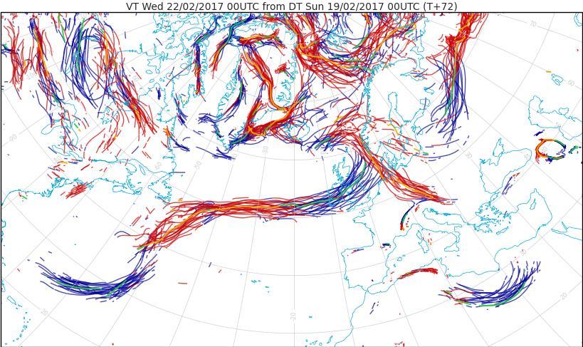

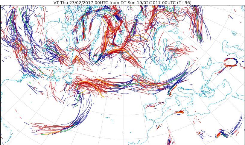


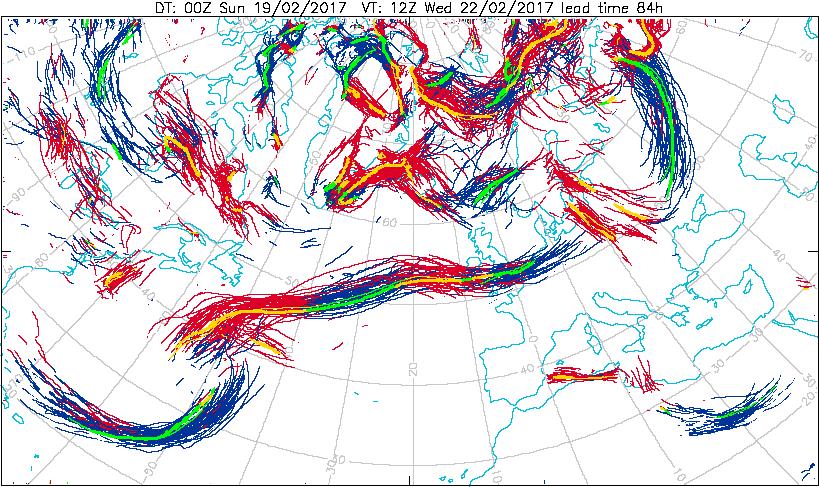

26 Cyclone database: Spaghetti fronts ECMWF ENS MOGREPS-G DT 00Z 19th Feb 4 days ahead of Storm Doris


27 Cyclone database: Dalmatian plots ECMWF ENS MOGREPS-G Spots show the location of cyclonic features in each member in the ensemble Size denotes the strength of the feature, while colours indicate the MSLP depth of the feature Background is the MSLP fields from the control run.


28 Cyclone database: Strike probability maps DT 00Z 19 th Feb T+96-T+120 Probability of a cyclonic feature with 1km wind speed maxima > 34kn tracking within 300km radius from 12h to +12h ECMWF ENS Next run: 12Z 19th Feb T+84-T+108 MOGREPS-G Next run: 12Z 19th Feb T+84-T+108 Strike probability charts are based on tracking feature points, not wind maxima. Only cyclonic features reaching a certain intensity threshold at some point in the 24h period are included. Here the threshold is that the max 1km wind speed within 300km must exceed 34kts. Strongest winds are likely to be to the right of the cyclone track Gives higher probabilities than at a point wind speed probabilities, extending the predictability
29 Ensemble Prediction System first guess warnings (EPS-W)

30 Likelihood Ensemble Prediction System First Guess Warnings (EPS-W) EPS-W post-processes ensemble data into a format which mimics the risk-based National Severe Weather Warning Service (NSWWS) colour states Mapped first guess warnings aid forecasters in deciding warning areas First-guess warnings are based on a combination of likelihood and impact as illustrated in the NSWWS weather impact matrix NSWWS weather impact matrix including likelihood probabilities, which are used in EPS-W only. High 60% Medium 40% Low 20% Very Low 1% Very Low Low Medium High Impact Overall warning colour key Regionally varying thresholds are used to define the impact levels Uses MOGREPS and ECMWF ENS
31 MOGREPS-G version of EPS-W (Overall warning colour for 10m wind gusts) 1 day forecast 2 day forecast 3 day forecast 4 day forecast 5 day forecast The 5 day warning highlights broad areas at risk across the UK. The area at risk reduces as the event draws closer. The main risk area also moves further south.
32 ECMWF version of EPS-W (Overall warning colour for 10m wind gusts) 1 day forecast 2 day forecast 3 day forecast 4 day forecast 5 day forecast The 5 day warning highlights broad areas at risk across the UK. The area at risk reduces as the event draws closer. The main risk area also moves further south. MOGREPS-G picks out amber areas 2 days earlier than ECMWF.
33 MOGREPS-G version of EPS-W (Overall warning colour for 3 hour snowfall) 1 day forecast 2 day forecast 3 day forecast 4 day forecast 5 day forecast The 5 day warning highlights broad areas at risk across the north of the UK, with warnings refined as lead time reduces.
34 PWS warnings


35 Final forecaster issued weather warnings Matrix location for snow and wind warnings

36
Medium-range Ensemble Forecasts at the Met Office
 Medium-range Ensemble Forecasts at the Met Office Christine Johnson, Richard Swinbank, Helen Titley and Simon Thompson ECMWF workshop on Ensembles Crown copyright 2007 Page 1 Medium-range ensembles at
Understanding Weather and Climate Risk. Matthew Perry Sharing an Uncertain World Conference The Geological Society, 13 July 2017
 Understanding Weather and Climate Risk Matthew Perry Sharing an Uncertain World Conference The Geological Society, 13 July 2017 What is risk in a weather and climate context? Hazard: something with the
Forecasting the "Beast from the East" and Storm Emma
 Forecasting the "Beast from the East" and Storm Emma Ken Mylne and Rob Neal with contributions from several scientists across the Met Office ECMWF UEF Meeting, 5-8 June 2018 Beast started 24 Feb Emma reached
MOGREPS short-range ensemble forecasting and the PREVIEW Windstorms Project
 MOGREPS short-range ensemble forecasting and the PREVIEW Windstorms Project Ken Mylne Thanks to all those who have contributed to both projects. Crown copyright 2007 Page 1 Outline MOGREPS System outline
ECMWF products to represent, quantify and communicate forecast uncertainty
 ECMWF products to represent, quantify and communicate forecast uncertainty Using ECMWF s Forecasts, 2015 David Richardson Head of Evaluation, Forecast Department David.Richardson@ecmwf.int ECMWF June 12,
The benefits and developments in ensemble wind forecasting
 The benefits and developments in ensemble wind forecasting Erik Andersson Slide 1 ECMWF European Centre for Medium-Range Weather Forecasts Slide 1 ECMWF s global forecasting system High resolution forecast
Application and verification of ECMWF products 2012
 Application and verification of ECMWF products 2012 Instituto Português do Mar e da Atmosfera, I.P. (IPMA) 1. Summary of major highlights ECMWF products are used as the main source of data for operational
Hazard Impact Modelling for Storms Workshop
 The UK s trusted voice for coordinated natural hazards advice Hazard Impact Modelling for Storms Workshop Ken Mylne, Becky Hemingway, Ervin Zsoter ECMWF UEF 2017, 15 th June 2017 The UK s trusted voice
The UK National Severe Weather Warning Service - Guidance Unit Perspective
 The UK National Severe Weather Warning Service - Guidance Unit Perspective Dan Suri, Chief Operational Meteorologist ECMWF User Workshop June 2015 Contents Who are the Guidance Unit? The National Severe
How ECMWF has addressed requests from the data users
 How ECMWF has addressed requests from the data users David Richardson Head of Evaluation Section, Forecast Department, ECMWF David.richardson@ecmwf.int ECMWF June 14, 2017 Overview Review the efforts made
Forecasting Extreme Events
 Forecasting Extreme Events Ivan Tsonevsky, ivan.tsonevsky@ecmwf.int Slide 1 Outline Introduction How can we define what is extreme? - Model climate (M-climate); The Extreme Forecast Index (EFI) Use and
Recent advances in Tropical Cyclone prediction using ensembles
 Recent advances in Tropical Cyclone prediction using ensembles Richard Swinbank, with thanks to Many colleagues in Met Office, GIFS-TIGGE WG & others HC-35 meeting, Curacao, April 2013 Recent advances
Flood Risk Forecasts for England and Wales: Production and Communication
 Staines Surrey Flood Risk Forecasts for England and Wales: Production and Communication Jon Millard UEF 2015 : Quantifying and Communicating Uncertainty FFC What is the FFC? Successful partnership between
Exploiting ensemble members: forecaster-driven EPS applications at the met office
 Exploiting ensemble members: forecaster-driven EPS applications at the met office Introduction Ensemble Prediction Systems (EPSs) have assumed a central role in the forecast process in recent years. The
Using Weather Pattern Analysis to Identify Periods of Heightened Coastal Flood Risk in the Medium to Long Range
 UEF 2017 - Storms Using Weather Pattern Analysis to Identify Periods of Heightened Coastal Flood Risk in the Medium to Long Range David Price (FFC) and Robert Neal (Met Office) Thursday 15 June The Flood
Application and verification of ECMWF products 2008
 Application and verification of ECMWF products 2008 RHMS of Serbia 1. Summary of major highlights ECMWF products are operationally used in Hydrometeorological Service of Serbia from the beginning of 2003.
Application and verification of the ECMWF products Report 2007
 Application and verification of the ECMWF products Report 2007 National Meteorological Administration Romania 1. Summary of major highlights The medium range forecast activity within the National Meteorological
Mio Matsueda (University of Oxford) Tetsuo Nakazawa (WMO)
 Tetsuo Nakazawa (WMO)") GIFS-TIGGE WG 10@UKMO (12-14 June, 2013) Early warning products for extreme weather events using operational medium-range ensemble forecasts Mio Matsueda (University of Oxford) Tetsuo Nakazawa (WMO) with
GIFS-TIGGE WG 10@UKMO (12-14 June, 2013) Early warning products for extreme weather events using operational medium-range ensemble forecasts Mio Matsueda (University of Oxford) Tetsuo Nakazawa (WMO) with
Fernando Prates. Evaluation Section. Slide 1
 Fernando Prates Evaluation Section Slide 1 Objectives Ø Have a better understanding of the Tropical Cyclone Products generated at ECMWF Ø Learn the recent developments in the forecast system and its impact
From Hazards to Impact: Experiences from the Hazard Impact Modelling project
 The UK s trusted voice for coordinated natural hazards advice From Hazards to Impact: Experiences from the Hazard Impact Modelling project Becky Hemingway, Met Office ECMWF UEF 2017, 14 th June 2017 [People]
Application and verification of ECMWF products 2016
 Application and verification of ECMWF products 2016 Icelandic Meteorological Office (www.vedur.is) Bolli Pálmason and Guðrún Nína Petersen 1. Summary of major highlights Medium range weather forecasts
How far in advance can we forecast cold/heat spells?
 Sub-seasonal time scales: a user-oriented verification approach How far in advance can we forecast cold/heat spells? Laura Ferranti, L. Magnusson, F. Vitart, D. Richardson, M. Rodwell Danube, Feb 2012
Have a better understanding of the Tropical Cyclone Products generated at ECMWF
 Objectives Have a better understanding of the Tropical Cyclone Products generated at ECMWF Learn about the recent developments in the forecast system and its impact on the Tropical Cyclone forecast Learn
The ECMWF Extended range forecasts
 The ECMWF Extended range forecasts Laura.Ferranti@ecmwf.int ECMWF, Reading, U.K. Slide 1 TC January 2014 Slide 1 The operational forecasting system l High resolution forecast: twice per day 16 km 91-level,
4.3.2 Configuration. 4.3 Ensemble Prediction System Introduction
 4.3 Ensemble Prediction System 4.3.1 Introduction JMA launched its operational ensemble prediction systems (EPSs) for one-month forecasting, one-week forecasting, and seasonal forecasting in March of 1996,
eccharts Ensemble data and recent updates Cihan Sahin, Sylvie Lamy-Thepaut, Baudouin Raoult Web development team, ECMWF
 eccharts Ensemble data and recent updates Cihan Sahin, Sylvie Lamy-Thepaut, Baudouin Raoult Web development team, ECMWF cihan.sahin@ecmwf.int ECMWF June 8, 2015 Outline eccharts Ensemble data in eccharts
Five years of limited-area ensemble activities at ARPA-SIM: the COSMO-LEPS system
 Five years of limited-area ensemble activities at ARPA-SIM: the COSMO-LEPS system Andrea Montani, Chiara Marsigli and Tiziana Paccagnella ARPA-SIM Hydrometeorological service of Emilia-Romagna, Italy 11
A review on recent progresses of THORPEX activities in JMA
 4th THORPEX workshop 31 Oct. 2012, Kunming, China A review on recent progresses of THORPEX activities in JMA Masaomi NAKAMURA Typhoon Research Department Meteorological Research Institute / JMA Contents
Recent ECMWF Developments
 Recent ECMWF Developments Tim Hewson (with contributions from many ECMWF colleagues!) tim.hewson@ecmwf.int ECMWF November 2, 2017 Outline Last Year IFS upgrade highlights 43r1 and 43r3 Standard web Chart
Application and verification of ECMWF products 2016
 Application and verification of ECMWF products 2016 RHMS of Serbia 1 Summary of major highlights ECMWF forecast products became the backbone in operational work during last several years. Starting from
Application and verification of ECMWF products 2009
 Application and verification of ECMWF products 2009 RHMS of Serbia 1. Summary of major highlights ECMWF products are operationally used in Hydrometeorological Service of Serbia from the beginning of 2003.
GPC Exeter forecast for winter Crown copyright Met Office
 GPC Exeter forecast for winter 2015-2016 Global Seasonal Forecast System version 5 (GloSea5) ensemble prediction system the source for Met Office monthly and seasonal forecasts uses a coupled model (atmosphere
Application and verification of ECMWF products in Norway 2008
 Application and verification of ECMWF products in Norway 2008 The Norwegian Meteorological Institute 1. Summary of major highlights The ECMWF products are widely used by forecasters to make forecasts for
New initiatives for Severe Weather prediction at ECMWF
 New initiatives for Severe Weather prediction at ECMWF Tim Hewson, Ivan Tsonevsky, Fernando Prates, Richard Forbes ECMWF Slide 1 Layout 1. EFI-related developments: - Upgraded Model Climate (M-Climate)
Verification of the Seasonal Forecast for the 2005/06 Winter
 Verification of the Seasonal Forecast for the 2005/06 Winter Shingo Yamada Tokyo Climate Center Japan Meteorological Agency 2006/11/02 7 th Joint Meeting on EAWM Contents 1. Verification of the Seasonal
Application and verification of ECMWF products 2017
 Application and verification of ECMWF products 2017 Finnish Meteorological Institute compiled by Weather and Safety Centre with help of several experts 1. Summary of major highlights FMI s forecasts are
Weather forecasts and warnings: Support for Impact based decision making
 Weather forecasts and warnings: Support for Impact based decision making Gerry Murphy, Met Éireann www.met.ie An Era of Change Climate and weather is changing Societal vulnerability is increasing The nature
Ensemble based first guess support towards a risk-based severe weather warning service
 METEOROLOGICAL APPLICATIONS Meteorol. Appl. 21: 563 577 (2014) Published online 22 February 2013 in Wiley Online Library (wileyonlinelibrary.com) DOI: 10.1002/met.1377 Ensemble based first guess support
Satellites, Weather and Climate Module??: Polar Vortex
 Satellites, Weather and Climate Module??: Polar Vortex SWAC Jan 2014 AKA Circumpolar Vortex Science or Hype? Will there be one this year? Today s objectives Pre and Post exams What is the Polar Vortex
Precipitation verification. Thanks to CMC, CPTEC, DWD, ECMWF, JMA, MF, NCEP, NRL, RHMC, UKMO
 Precipitation verification Thanks to CMC, CPTEC, DWD, ECMWF, JMA, MF, NCEP, NRL, RHMC, UKMO Outline 1) Status of WGNE QPF intercomparisons 2) Overview of the use of recommended methods for the verification
Feature-specific verification of ensemble forecasts
 Feature-specific verification of ensemble forecasts www.cawcr.gov.au Beth Ebert CAWCR Weather & Environmental Prediction Group Uncertainty information in forecasting For high impact events, forecasters
Application and verification of ECMWF products 2018
 Application and verification of ECMWF products 2018 National Meteorological Administration, Romania 1. Summary of major highlights In the field of numerical model verification, the daily GRID_STAT method
OBJECTIVE CALIBRATED WIND SPEED AND CROSSWIND PROBABILISTIC FORECASTS FOR THE HONG KONG INTERNATIONAL AIRPORT
 P 333 OBJECTIVE CALIBRATED WIND SPEED AND CROSSWIND PROBABILISTIC FORECASTS FOR THE HONG KONG INTERNATIONAL AIRPORT P. Cheung, C. C. Lam* Hong Kong Observatory, Hong Kong, China 1. INTRODUCTION Wind is
Verification statistics and evaluations of ECMWF forecasts in
 635 Verification statistics and evaluations of ECMWF forecasts in 29-21 D.S. Richardson, J. Bidlot, L. Ferranti, A. Ghelli, T. Hewson, M. Janousek, F. Prates and F. Vitart Operations Department October
Ensemble Prediction Systems
 Ensemble Prediction Systems Eric Blake National Hurricane Center 7 March 2017 Acknowledgements to Michael Brennan 1 Question 1 What are some current advantages of using single-model ensembles? A. Estimates
European Flooding, Summer 2013
 European Flooding, Summer 2013 Fredrik ikwetterhall Florian Pappenberger, Clement Albergel, Lorenzo Alfieri, Gianpaolo Balsamo, Konrad Bogner, Thomas Haiden, Tim Hewson, Linus Magnusson, Patricia de Rosnay,
Application and verification of ECMWF products 2015
 Application and verification of ECMWF products 2015 Hungarian Meteorological Service 1. Summary of major highlights The objective verification of ECMWF forecasts have been continued on all the time ranges
09 December 2005 snow event by Richard H. Grumm National Weather Service Office State College, PA 16803
 09 December 2005 snow event by Richard H. Grumm National Weather Service Office State College, PA 16803 1. INTRODUCTION A winter storm produced heavy snow over a large portion of Pennsylvania on 8-9 December
World Weather Research Program: a ten years vision. PM Ruti, F Vitart, S Majumdar IWTC VIII Dec Jeju
 World Weather Research Program: a ten years vision PM Ruti, F Vitart, S Majumdar IWTC VIII Dec 014 - Jeju An overarching question Disaster risk reduction Climate services How should we move from weather
Global Flash Flood Forecasting from the ECMWF Ensemble
 Global Flash Flood Forecasting from the ECMWF Ensemble Calumn Baugh, Toni Jurlina, Christel Prudhomme, Florian Pappenberger calum.baugh@ecmwf.int ECMWF February 14, 2018 Building a Global FF System 1.
Application and verification of ECMWF products 2012
 Application and verification of ECMWF products 2012 National Meteorological Administration 1. Summary of major highlights The objective verification of all deterministic models forecasts in use have been
Adaptation by Design: The Impact of the Changing Climate on Infrastructure
 Adaptation by Design: The Impact of the Changing Climate on Infrastructure Heather Auld, J Klaassen, S Fernandez, S Eng, S Cheng, D MacIver, N Comer Adaptation and Impacts Research Division Environment
TC/PR/RB Lecture 3 - Simulation of Random Model Errors
 TC/PR/RB Lecture 3 - Simulation of Random Model Errors Roberto Buizza (buizza@ecmwf.int) European Centre for Medium-Range Weather Forecasts http://www.ecmwf.int Roberto Buizza (buizza@ecmwf.int) 1 ECMWF
Application and verification of ECMWF products 2010
 Application and verification of ECMWF products Hydrological and meteorological service of Croatia (DHMZ) Lovro Kalin. Summary of major highlights At DHMZ, ECMWF products are regarded as the major source
Predictability from a Forecast Provider s Perspective
 Predictability from a Forecast Provider s Perspective Ken Mylne Met Office, Bracknell RG12 2SZ, UK. email: ken.mylne@metoffice.com 1. Introduction Predictability is not a new issue for forecasters or forecast
The Impact of Horizontal Resolution and Ensemble Size on Probabilistic Forecasts of Precipitation by the ECMWF EPS
 The Impact of Horizontal Resolution and Ensemble Size on Probabilistic Forecasts of Precipitation by the ECMWF EPS S. L. Mullen Univ. of Arizona R. Buizza ECMWF University of Wisconsin Predictability Workshop,
Thanksgiving Snow and Arctic Front 25 November 2005 By Richard H. Grumm National Weather Service State College, PA 16801
 Thanksgiving Snow and Arctic Front 25 November 2005 By Richard H. Grumm National Weather Service State College, PA 16801 1. INTRODUCTION An approaching arctic front brought light snow to most of western
Calibrating forecasts of heavy precipitation in river catchments
 from Newsletter Number 152 Summer 217 METEOROLOGY Calibrating forecasts of heavy precipitation in river catchments Hurricane Patricia off the coast of Mexico on 23 October 215 ( 215 EUMETSAT) doi:1.21957/cf1598
Application and verification of ECMWF products 2016
 Application and verification of ECMWF products 2016 Meteorological and Hydrological Service of Croatia Lovro Kalin and Zoran Vakula 1. Summary of major highlights At Meteorological and Hydrological Service
Application and verification of ECMWF products 2011
 Application and verification of ECMWF products 2011 National Meteorological Administration 1. Summary of major highlights Medium range weather forecasts are primarily based on the results of ECMWF and
1. INTRODUCTION * Figure 1. National Weather Service Storm Prediction Center (SPC) storm reports for December 1, 2006.
 storm reports for December 1, 2006.") P1.14 FORECAST ISSUES RELATED TO THE UNPRECEDENTED SEVERE AND HIGH WIND EVENT OF DECEMBER 2006 by Greg A. DeVoir* and Richard H. Grumm National Weather Service Office State College, PA 16803 1. INTRODUCTION
P1.14 FORECAST ISSUES RELATED TO THE UNPRECEDENTED SEVERE AND HIGH WIND EVENT OF DECEMBER 2006 by Greg A. DeVoir* and Richard H. Grumm National Weather Service Office State College, PA 16803 1. INTRODUCTION
Verification of ECMWF products at the Finnish Meteorological Institute
 Verification of ECMWF products at the Finnish Meteorological Institute by Juha Kilpinen, Pertti Nurmi and Matias Brockmann 1. Summary of major highlights The new verification system is under pre-operational
Seasonal prediction of extreme events
 Seasonal prediction of extreme events C. Prodhomme, F. Doblas-Reyes MedCOF training, 29 October 2015, Madrid Climate Forecasting Unit Outline: Why focusing on extreme events? Extremeness metric Soil influence
Tropical Cyclone Formation/Structure/Motion Studies
 Tropical Cyclone Formation/Structure/Motion Studies Patrick A. Harr Department of Meteorology Naval Postgraduate School Monterey, CA 93943-5114 phone: (831) 656-3787 fax: (831) 656-3061 email: paharr@nps.edu
Southern United States Winter Storm of 28 January 2014-v1. High Impact Snow on Edge of Forecast Precipitation Shield
 Southern United States Winter Storm of 28 January 2014-v1 High Impact Snow on Edge of Forecast Precipitation Shield by Richard H. Grumm National Weather Service State College, PA 16803 and 1. Introduction
Skilful seasonal predictions for the European Energy Industry
 Skilful seasonal predictions for the European Energy Industry Hazel Thornton, Philip Bett, Robin Clark, Adam Scaife, Brian Hoskins, David Brayshaw WGSIP, 10/10/2017 Outline Energy industry and climate
Application and verification of ECMWF products at the Finnish Meteorological Institute
 Application and verification of ECMWF products 2010 2011 at the Finnish Meteorological Institute by Juhana Hyrkkènen, Ari-Juhani Punkka, Henri Nyman and Janne Kauhanen 1. Summary of major highlights ECMWF
Northeastern United States Snowstorm of 9 February 2017
 Northeastern United States Snowstorm of 9 February 2017 By Richard H. Grumm and Charles Ross National Weather Service State College, PA 1. Overview A strong shortwave produced a stripe of precipitation
Application and verification of ECMWF products 2014
 Application and verification of ECMWF products 2014 Israel Meteorological Service (IMS), 1. Summary of major highlights ECMWF deterministic runs are used to issue most of the operational forecasts at IMS.
JMA Contribution to SWFDDP in RAV. (Submitted by Yuki Honda and Masayuki Kyouda, Japan Meteorological Agency) Summary and purpose of document
 Summary and purpose of document") WORLD METEOROLOGICAL ORGANIZATION COMMISSION FOR BASIC SYSTEMS OPAG on DPFS DPFS/RAV-SWFDDP-RSMT Doc. 7.1(1) (28.X.2010) SEVERE WEATHER FORECASTING AND DISASTER RISK REDUCTION DEMONSTRATION PROJECT (SWFDDP)
WORLD METEOROLOGICAL ORGANIZATION COMMISSION FOR BASIC SYSTEMS OPAG on DPFS DPFS/RAV-SWFDDP-RSMT Doc. 7.1(1) (28.X.2010) SEVERE WEATHER FORECASTING AND DISASTER RISK REDUCTION DEMONSTRATION PROJECT (SWFDDP)
A Preliminary Severe Winter Storms Climatology for Missouri from
 A Preliminary Severe Winter Storms Climatology for Missouri from 1960-2010 K.L. Crandall and P.S Market University of Missouri Department of Soil, Environmental and Atmospheric Sciences Introduction The
From Climate Science to Climate Services
 Making sense of complexity in an interdependent world: February 2013 From Climate Science to Climate Services Julia Slingo, Met Office Chief Scientist Climate Change: Taking the planet into uncharted territory?
Verification of ECMWF products at the Deutscher Wetterdienst (DWD)
") Verification of ECMWF products at the Deutscher Wetterdienst (DWD) DWD Martin Göber 1. Summary of major highlights The usage of a combined GME-MOS and ECMWF-MOS continues to lead to a further increase
Verification of ECMWF products at the Deutscher Wetterdienst (DWD) DWD Martin Göber 1. Summary of major highlights The usage of a combined GME-MOS and ECMWF-MOS continues to lead to a further increase
Monthly forecast and the Summer 2003 heat wave over Europe: a case study
 ATMOSPHERIC SCIENCE LETTERS Atmos. Sci. Let. 6: 112 117 (2005) Published online 21 April 2005 in Wiley InterScience (www.interscience.wiley.com). DOI: 10.1002/asl.99 Monthly forecast and the Summer 2003
August Forecast Update for Atlantic Hurricane Activity in 2012
 August Forecast Update for Atlantic Hurricane Activity in 2012 Issued: 6 th August 2012 by Professor Mark Saunders and Dr Adam Lea Dept. of Space and Climate Physics, UCL (University College London), UK
Winter Storm of 15 December 2005 By Richard H. Grumm National Weather Service Office State College, PA 16803
 Winter Storm of 15 December 2005 By Richard H. Grumm National Weather Service Office State College, PA 16803 1. INTRODUCTION A complex winter storm brought snow, sleet, and freezing rain to central Pennsylvania.
Probabilistic Weather Forecasting and the EPS at ECMWF
 Probabilistic Weather Forecasting and the EPS at ECMWF Renate Hagedorn European Centre for Medium-Range Weather Forecasts 30 January 2009: Ensemble Prediction at ECMWF 1/ 30 Questions What is an Ensemble
The National Weather Service of the Future: Building a Weather-Ready Nation
 The of the Future: Building a Weather-Ready Nation Dr. Louis W. Uccellini Director, NOAA Assistant Administrator for Weather Services NCEP Production Suite Review December 2, 2014 Outline Building a Weather-Ready
HPC Ensemble Uses and Needs
 1 HPC Ensemble Uses and Needs David Novak Science and Operations Officer With contributions from Keith Brill, Mike Bodner, Tony Fracasso, Mike Eckert, Dan Petersen, Marty Rausch, Mike Schichtel, Kenneth
Fire Weather Drivers, Seasonal Outlook and Climate Change. Steven McGibbony, Severe Weather Manager Victoria Region Friday 9 October 2015
 Fire Weather Drivers, Seasonal Outlook and Climate Change Steven McGibbony, Severe Weather Manager Victoria Region Friday 9 October 2015 Outline Weather and Fire Risk Environmental conditions leading to
Multi-scale Predictability Aspects of a Severe European Winter Storm
 1 Multi-scale Predictability Aspects of a Severe European Winter Storm NASA MODIS James D. Doyle, C. Amerault, P. A. Reinecke, C. Reynolds Naval Research Laboratory, Monterey, CA Mesoscale Predictability
Weather Hazard Modeling Research and development: Recent Advances and Plans
 Weather Hazard Modeling Research and development: Recent Advances and Plans Stephen S. Weygandt Curtis Alexander, Stan Benjamin, Geoff Manikin*, Tanya Smirnova, Ming Hu NOAA Earth System Research Laboratory
Adaptation for global application of calibration and downscaling methods of medium range ensemble weather forecasts
 Adaptation for global application of calibration and downscaling methods of medium range ensemble weather forecasts Nathalie Voisin Hydrology Group Seminar UW 11/18/2009 Objective Develop a medium range
Satellites, Weather and Climate Module 9: Air/sea interactions winter cyclogenesis
 Satellites, Weather and Climate Module 9: Air/sea interactions winter cyclogenesis Winter storms things to consider Deep moisture Thermal discontinuity Favorable surface and upper level features Geographical
Pre-Christmas Warm-up December 2013-Draft
 Pre-Christmas Warm-up 21-23 December 2013-Draft By Richard H. Grumm National Weather Service State College, PA 1. Overview A large ridge over the west-central Atlantic (Fig.1) and trough moving into eastern
Impacts of the April 2013 Mean trough over central North America
 Impacts of the April 2013 Mean trough over central North America By Richard H. Grumm National Weather Service State College, PA Abstract: The mean 500 hpa flow over North America featured a trough over
The Devastating Western European Winter Storm February 2010 By Richard H. Grumm National Weather Service
 The Devastating Western European Winter Storm 27-28 February 2010 By Richard H. Grumm National Weather Service 1. INTRODUCTION A strong late winter storm, called Xynthia 1, raced across Western Europe
Clustering Techniques and their applications at ECMWF
 Clustering Techniques and their applications at ECMWF Laura Ferranti European Centre for Medium-Range Weather Forecasts Training Course NWP-PR: Clustering techniques and their applications at ECMWF 1/32
Nerushev A.F., Barkhatov A.E. Research and Production Association "Typhoon" 4 Pobedy Street, , Obninsk, Kaluga Region, Russia.
 DETERMINATION OF ATMOSPHERIC CHARACTERISTICS IN THE ZONE OF ACTION OF EXTRA-TROPICAL CYCLONE XYNTHIA (FEBRUARY 2010) INFERRED FROM SATELLITE MEASUREMENT DATA Nerushev A.F., Barkhatov A.E. Research and
Operational event attribution
 Operational event attribution Peter Stott, NCAR, 26 January, 2009 August 2003 Events July 2007 January 2009 January 2009 Is global warming slowing down? Arctic Sea Ice Climatesafety.org climatesafety.org
Minor Winter Flooding Event in northwestern Pennsylvania January 2017
 1. Overview Minor Winter Flooding Event in northwestern Pennsylvania 12-13 January 2017 By Richard H. Grumm National Weather Service State College, PA A combination of snow melt, frozen ground, and areas
El Niño Update Impacts on Florida
 Current Issues in Emergency Management (CIEM) Sessions 1 &2 October 12 th and 26 th, 2006 Florida Division of Emergency Management Tallahassee, Florida El Niño Update Impacts on Florida Bart Hagemeyer
Severe Freezing Rain in Slovenia
 Severe Freezing Rain in Slovenia Janez Markosek, Environmental Agency, Slovenia Introduction At the end of January and at the beginning of February 2014, severe and long-lasting freezing rain affected
An integrated assessment of the potential for change in storm activity over Europe: implications for forestry in the UK
 International Conference Wind Effects on Trees September 16-18, 3, University of Karlsruhe, Germany An integrated assessment of the potential for change in storm activity over Europe: implications for
Global Flood Awareness System GloFAS
 Global Flood Awareness System GloFAS Ervin Zsoter with the help of the whole EFAS/GloFAS team Ervin.Zsoter@ecmwf.int 1 Reading, 8-9 May 2018 What is GloFAS? Global-scale ensemble-based flood forecasting
Mozambique. General Climate. UNDP Climate Change Country Profiles. C. McSweeney 1, M. New 1,2 and G. Lizcano 1
 UNDP Climate Change Country Profiles Mozambique C. McSweeney 1, M. New 1,2 and G. Lizcano 1 1. School of Geography and Environment, University of Oxford. 2.Tyndall Centre for Climate Change Research http://country-profiles.geog.ox.ac.uk
Cataloguing high impact Weather and Climate Events
 Cataloguing high impact Weather and Climate Events Omar Baddour Chief Data Management Applications Divison World Meteorological Organisation Geneva, Switzerland 2 3 Estimating and cataloguing loss & damage
Goals of Presentation
 Hydrometeorlogical Prediction Center (HPC) Forecast Operations Branch Winter Weather Desk Dan Petersen Dan.Petersen@noaa.gov 301-763-8201 Review HPC winter weather desk forecasts Review winter weather
Monitoring and Prediction of Climate Extremes
 Monitoring and Prediction of Climate Extremes Stephen Baxter Meteorologist, Climate Prediction Center NOAA/NWS/NCEP Deicing and Stormwater Management Conference ACI-NA/A4A Arlington, VA May 19, 2017 What
Extratropical and Polar Cloud Systems
 Extratropical and Polar Cloud Systems Gunilla Svensson Department of Meteorology & Bolin Centre for Climate Research George Tselioudis Extratropical and Polar Cloud Systems Lecture 1 Extratropical cyclones