Improvements for Kosovo's spatial planning system / [presentation given in May 2011]
|
|
|
- Tyrone Matthews
- 5 years ago
- Views:
Transcription
1 Rochester Institute of Technology RIT Scholar Works Theses Thesis/Dissertation Collections 2011 Improvements for Kosovo's spatial planning system / [presentation given in May 2011] Luan Nushi Follow this and additional works at: Recommended Citation Nushi, Luan, "Improvements for Kosovo's spatial planning system / [presentation given in May 2011]" (2011). Thesis. Rochester Institute of Technology. Accessed from This Master's Project is brought to you for free and open access by the Thesis/Dissertation Collections at RIT Scholar Works. It has been accepted for inclusion in Theses by an authorized administrator of RIT Scholar Works. For more information, please contact ritscholarworks@rit.edu.
2 AUK & RIT Improvements for Kosovo s Spatial Planning System Capstone Project in partial fulfillment of a Master of Science Degree in Professional Studies at the RIT Center for Multidisciplinary Studies Luan Nushi May 2011


3 What are the causes? What is the structure? What are the technical and human capacities? and What is the actual communication? Structure of activities 2
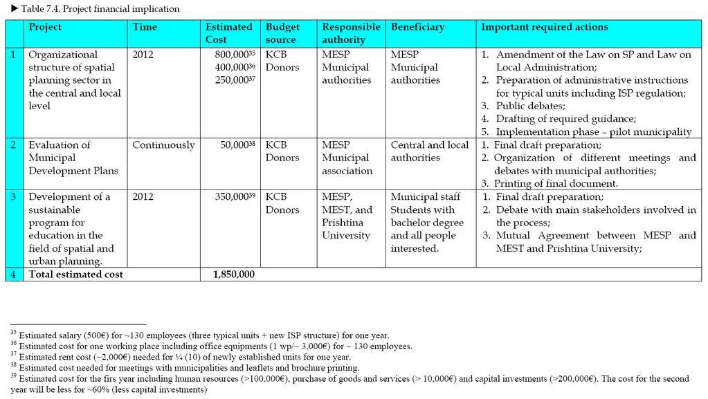
4 Main recommendations Better organization of spatial planning sector; Better evaluation of Municipal Development Plans; Master program as a sustainable form for education. to start an immediate plan for remedying this situation a budget of 1.8 Mil is required approximately 0.13% of the overall Kosovo budget of ~1.5 Bil. 3

5 METHODOLOGY AND DATA COLLECTION Combination of the research realized in the internet; Debates and interviews; Typical Kosovo municipalities (selected under defined criteria s) Questionnaire Designated for the respective municipal staff; Designated for professionals in the planning field; 22 questions and issues which were classified into five areas: Budget; Municipal organizational structure; Functions; Municipal plans; and Relationship between central and municipal level; 4
6 Questionnaire dedicated for central authority and professional staff 5

7 Selection criteria s 6


8 EU AND US SPATIAL PLANNING SYSTEMS EU Spatial planning system No formal competence for spatial planning in the European Union; No common planning system for the European countries; However, many EU sector policies and conceptions have a considerable implications for the spatial development of individual member states; Essential principles of spatial planning for future development of national spatial systems: Profile of demands for national spatial planning 7


9 Four major SP traditions within EU The regional economic planning approach; The comprehensive integrated approach; The land use management approach; The Urbanism approach. US spatial planning system SP policies emerge from a primary orientation of all levels of government towards an attitude of the supremacy of the market and market-led solutions; The structure of the planning system is not much integrated; Therefore there is no strategy for planning; Spatial or territorial planning, is not a part of the American legal or professional planning vocabulary; 8


10 Existing situation SPATIAL PLANNING SYSTEM IN KOSOVO Spatial planning should be an instrument for coordinating the developments in the space and instrument for territorial cohesion; History From Conventional to Strategic approach; 2003 the new Law on Spatial Planning was approved and amended on November 2008; Half of the municipalities in Kosovo have completed the process; Under the coordination of MESP there are several completed draft plans of the state interest; 9


 Pr.")

11 Existing situation Spatial Planning Institutions MESP - is responsible for the coordination of spatial planning in Kosovo also responsible for reviewing, monitoring and harmonization of the planning process at the municipal level Central level represented by the Spatial Planning Sector composed of DSP and ISP; The council for spatial planning is a consultative body of the Government of Kosovo Local level (municipal), represented by relevant directories of planning and urban management; Communication (results of quest.) Pr. No The Municipal Committee of Planning Experts appointed by Municipal Assembly for the purpose of Gj. accomplishing No the professional works; Fe. Should increase Li. Should be more contacts Dr. Should be an extensive coop. Ju. Yes 10
12 Human and Technical Capacities Spatial planning work is mainly carried out by architects and urban planners; Urban services is the main engagement; Lack of human capacities; Lack of particular municipal plans; Increased demand for construction; Technical aspect; Inability of GIS application; Evaluation (results of quest.) Pr. - Gj. No substantial; Fe. In more timely manner; Li. Also URP should be evalu. Dr. More responsibility. Ju. Yes Municipality X MDP submission to MESP for approval MDP document (a copy) documented for received from MESP MESP/Office of PS MESP/DSP (Department of Spatial Planning) MESP/Working Group Evaluation and Implementation of spatial planning documents; Report of MDP evaluation 11

13 1 Options Organizational option for central level (DSP ISP) Solutions from the countries in the region MACEDONIA; CROATIA; SLOVENIA; and SERBIA; 12
14 1 BASIC WORKABLE STRUCTURE OF DSP AND ISP Department for Spatial Planning Central Monitoring Division Policy Division Local Monitoring Division Institute for Spatial Planning Planning Division Research Division Technical Support Division 13
 and 12.500 inh.")

15 1 Options ORGANIZATIONAL OPTION FOR MUNICIPAL LEVEL Municipal spatial planning unit (MSPU) Large difference between municipalities; Municipality of Prishtina (572 km2) and 450,000 and Municipality of Junik (87 km2) and inh.; MSPU adequate to classification defined in the SPK: Capital City - Large Municipality and Small Municipality; Strengths and opportunities mechanism that will facilitate the process of drafting and implementation of spatial and urban plans; Weaknesses and obstacles budget constraints; lack of professionals; new organizational structure will only increase administration; Municipal classification Capital of Kosovo Large centers Small centers 14
16 2 Options THE EVALUATION OF MDPs Submission in the following stages: First stage - Profile & analysis; Municipal Vision; Framework for spatial development Second Stage - The spatial strategy & actions; Implementation planning Third Stage - Formal submission of the draft MDP as required by Article 13 (13.9) of the LSP. 15
17 3 Options LONG TERM CAPACITY BUILDING Who is engaged in Spatial Planning Existing situation (Faculty of Architecture, Geography and some courses in Economy and Social Sciences); Three main roles for planners are defined: political role, the technical expertise and the managerial role MASTER PROGRAMME in spatial planning is considered as a best approach for sustainable human capacity building Sustainable capacity building (results of quest.) Pr. - Municipal-Central fund for education Gj. -?; Fe. GIS - training; Li. Training in and out of the country; Dr. Specialized trainings; Ju. Workshops and trainings in and out of the country; From 11 respond.: 9 in favor of Master Program 2 with similar ideas (profess. courses etc.) 16
18 3 Options LONG TERM CAPACITY BUILDING This includes qualifying students to: Understand, plan and manage change in the built and natural environments, at the local, municipal and regional levels. Work on the basis of principles of economic, social and environmental sustainability. Contribute to open and democratic decision-making processes, including involvement of civil society, transparency and accountability. Who will be the beneficiaries - the core part of first group of students will be representatives of civil servants from both planning levels; Better communication 17
19 18
20 Sectoral un-harmonized actions Inter sectoral coordinated action Criteria: Low cost Efficient services Maintenance Duration
The purpose of this report is to recommend a Geographic Information System (GIS) Strategy for the Town of Richmond Hill.
 Strategy for the Town of Richmond Hill.") Staff Report for Committee of the Whole Meeting Department: Division: Subject: Office of the Chief Administrative Officer Strategic Initiatives SRCAO.18.12 GIS Strategy Purpose: The purpose of this report
Staff Report for Committee of the Whole Meeting Department: Division: Subject: Office of the Chief Administrative Officer Strategic Initiatives SRCAO.18.12 GIS Strategy Purpose: The purpose of this report
National Land Use Policy and National Integrated Planning Framework for Land Resource Development
 Title National Land Use Policy and National Integrated Planning Framework for Land Resource Development Duration: 32 Weeks Objective: Adoption of appropriate land use planning approaches to: Maintain the
Key Indicators for Territorial Cohesion & Spatial Planning Stakeholder Workshop - Project Update. 13 th December 2012 San Sebastián, Basque Country
 Key Indicators for Territorial Cohesion & Spatial Planning Stakeholder Workshop - Project Update 13 th December 2012 San Sebastián, Basque Country Key Aims Explore the use of territorial data in developing
Law on Spatial Planning
 UNITED NATIONS United Nations Interim Administration Mission in Kosovo UNMIK NATIONS UNIES Mission d Administration Intérimaire des Nations Unies au Kosovo PROVISIONAL INSTITUTIONS OF SELF GOVERNMENT Law
CEMAT results - over the years
 CEMAT results - over the years Technical Conference on Functional Areas capitalization of local potential within the territorial development policies in Europe European Conference of Ministers responsible
UN-GGIM: Strengthening Geospatial Capability
 Fifth Plenary Meeting of UN-GGIM: Europe Brussels, 6-7 June 2018 UN-GGIM: Strengthening Geospatial Capability Walking the talk to leave no one behind Greg Scott, UN-GGIM Secretariat Environmental Statistics
The National Spatial Strategy
 Purpose of this Consultation Paper This paper seeks the views of a wide range of bodies, interests and members of the public on the issues which the National Spatial Strategy should address. These views
Economic and Social Council
 United Nations Economic and Social Council Distr.: General 18 July 2016 Original: English Committee of Experts on Global Geospatial Information Management Sixth session New York, 3-5 August 2016 Item 2
KUNMING FORUM ON UNITED NATIONS GLOBAL GEOSPATIAL INFORMATION MANAGEMENT CITIES OF THE FUTURE: SMART, RESILIENT
 KUNMING FORUM ON UNITED NATIONS GLOBAL GEOSPATIAL INFORMATION MANAGEMENT CITIES OF THE FUTURE: SMART, RESILIENT and SUSTAINABLE Yunnan Zhenzhuang Guest House, Kunming, China 10 12 May 2017 BACKGROUND CONCEPT
Urban Studies Applicable to students admitted in
 Urban Studies Applicable to students admitted in 2014-15 Major Programme Requirement Students are required to complete a minimum of 8 units of courses as follows: 1. Faculty Package: 9 Any three courses,
SPIMA Spatial dynamics and strategic planning in metropolitan areas
 Targeted Analysis SPIMA Spatial dynamics and strategic planning in metropolitan areas Executive Summary Conference version 1 February 2018 0 1. Background To address the challenges of metropolitan development
Urban Climate Resilience
 Urban Climate Resilience in Southeast Asia Partnership Project Introduction Planning for climate change is a daunting challenge for governments in the Mekong Region. Limited capacity at the municipal level,
THE NEW CHALLENGES FOR THE HIGHER EDUCATION OF GEODESY IN UACEG SOFIA
 THE NEW CHALLENGES FOR THE HIGHER EDUCATION OF GEODESY IN UACEG SOFIA Ivan Kunchev University of Architecture, Civil Engineering and Geodesy, 1 Hristo Smirnenski Blvd., Sofia 1046, Bulgaria Abstract Report
Advanced Readings. Environment and Land Use Concentration The following seminars and studios would apply
 Community Development and Housing Concentration URP 720 Urban Housing Policies URP 722 Community Development and Housing URP 724 Urban Revitalization Studio URP 726 Citizen Participation Strategies URP
MODELS AND TOOLS FOR GOVERNANCE OF
 Working Papers Collection No. 1/2015 MODELS AND TOOLS FOR GOVERNANCE OF THE ADRIATIC AND IONIAN SEAS www.unimc.it/maremap NATIONAL POLITICS AND EU POLITICS: THE MARITIME SPATIAL PLANNING AND INTEGRATED
SPLAN-Natura Towards an integrated spatial planning approach for Natura th January, 2017 Brussels. Commissioned by DG Environment
 SPLAN-Natura 2000 Towards an integrated spatial planning approach for Natura 2000 Commissioned by DG Environment 17 th January, 2017 Brussels V. Simeonova (Ph.D.) Drivers towards integrating Biodiversity
Alps Results from the ESPON Project. Common spatial perspectives for the Alpine area. Towards a common vision
 Results from the ESPON Project Alps 2050 Common spatial perspectives for the Alpine area. Towards a common vision Tobias Chilla, University of Erlangen Cooperation Alps 2020+ 1 & 2 October 2018 Salzburg
PLANNING (PLAN) Planning (PLAN) 1
 Planning (PLAN) 1") Planning (PLAN) 1 PLANNING (PLAN) PLAN 500. Economics for Public Affairs Description: An introduction to basic economic concepts and their application to public affairs and urban planning. Note: Cross-listed
Planning (PLAN) 1 PLANNING (PLAN) PLAN 500. Economics for Public Affairs Description: An introduction to basic economic concepts and their application to public affairs and urban planning. Note: Cross-listed
SPIMA Spatial dynamics and strategic planning in metropolitan areas
 SPIMA Spatial dynamics and strategic planning in metropolitan areas Dr. Vanya Simeonova Wageningen Environmental Research Wageningen University and research, The Netherlands Key outcomes: SPIMA Framework
Implementing the Sustainable Development Goals: The Role of Geospatial Technology and Innovation
 Fifth High Level Forum on UN Global Geospatial Information Management Implementing the Sustainable Development Goals: The Role of Geospatial Technology and Innovation 28-30 November 2017 Sheraton Maria
What s the problem? A Modern Odyssey in Search of Relevance. The search for relevance. Some current drivers for new services. Some Major Applications
 A Modern Odyssey in Search of Relevance FIG Working Week, Athens, 24 May 2004 Paul Kelly ANZLIC Executive Director The search for relevance 1. New expectations for spatial services 2. Are we ready to meet
Smart City Governance for effective urban governance. David Ludlow Assoc. Professor European Smart Cities University of the West of England, Bristol
 Smart City Governance for effective urban governance David Ludlow Assoc. Professor European Smart Cities University of the West of England, Bristol Complexities of urban territorial governance Complexities
Policy and Legal Frameworks: The journey so far
 International Forum on Policy and Legal Frameworks for Geospatial Information, 18-19 October 2016, Kuala Lumpur, Malaysia Policy and Legal Frameworks: The journey so far Greg Scott Global Geospatial Information
International Guidelines on Access to Basic Services for All
 International Guidelines on Access to Basic Services for All Presentation and initials lessons from implementation Accessibility to services in regions and cities : measures and policies, OECD 18 June
Spatial Analysis and Modeling of Urban Land Use Changes in Lusaka, Zambia: A Case Study of a Rapidly Urbanizing Sub- Saharan African City
 Spatial Analysis and Modeling of Urban Land Use Changes in Lusaka, Zambia: A Case Study of a Rapidly Urbanizing Sub- Saharan African City January 2018 Matamyo SIMWANDA Spatial Analysis and Modeling of
COUNCIL OF THE EUROPEAN UNION. Brussels, 2 May /14 CULT 68
 COUNCIL OF THE EUROPEAN UNION Brussels, 2 May 2014 9129/14 CULT 68 NOTE from: General Secretariat of the Council to: Permanent Representatives Committee (Part 1) / Council No. prev. doc.: 8892/14 CULT
geographic patterns and processes are captured and represented using computer technologies
 Proposed Certificate in Geographic Information Science Department of Geographical and Sustainability Sciences Submitted: November 9, 2016 Geographic information systems (GIS) capture the complex spatial
OFFICIAL GAZETTE OF THE REPUBLIC OF KOSOVA / No. 30 / 23 AUGUST 2013, PRISTINA LAW NO. 04/L-174 ON SPATIAL PLANNING LAW ON SPATIAL PLANNING
 OFFICIAL GAZETTE OF THE REPUBLIC OF KOSOVA / No. 30 / 23 AUGUST 2013, PRISTINA LAW NO. 04/L-174 ON SPATIAL PLANNING Assembly of Republic of Kosovo; Pursuant to Article 65 (1) of the Constitution of Republic
The Council of Europe Spatial/ Regional Planning (CEMAT) considering Landscape with its Heritage Values
 considering Landscape with its Heritage Values") The Council of Europe Spatial/ Regional Planning (CEMAT) considering Landscape with its Heritage Values Report to The Council of Europe Directorate of Culture and Cultural and Natural Heritage 30 April
The Council of Europe Spatial/ Regional Planning (CEMAT) considering Landscape with its Heritage Values Report to The Council of Europe Directorate of Culture and Cultural and Natural Heritage 30 April
Date: March 31, 2014 PATE; fyril 2.3,2 >H
 aj BRAMPTON fifs Rower City XH-l-f r.t "»* City Council The Corporation of the City of Brampton SRAMPTON CITY COUNCIL Date: March 31, 2014 PATE; fyril 2.3,2 >H File: POO GR VisWhtoJed ^t'th-meeh'^a Subject:
Land Use in the context of sustainable, smart and inclusive growth
 Land Use in the context of sustainable, smart and inclusive growth François Salgé Ministry of sustainable development France facilitator EUROGI vice president AFIGéO board member 1 Introduction e-content+
16540/14 EE/cm 1 DG E 1A
 Council of the European Union Brussels, 5 December 2014 (OR. en) 16540/14 ENV 965 CULT 139 NOTE From: To: Subject: General Secretariat of the Council Delegations Charter of Rome on Natural and Cultural
TERRITORIAL IMPACT ASSESSMENT: AN APPROACH TO IMPROVE THE VERTICAL AND HORIZONTAL INTEGRATION OF EU POLICIES
 TERRITORIAL IMPACT ASSESSMENT: AN APPROACH TO IMPROVE THE VERTICAL AND HORIZONTAL INTEGRATION OF EU POLICIES Naja Marot & Mojca Golobič Biotehnical Faculty, University of Ljubljana, Slovenia RSA Workshop
JOB DESCRIPTION. Research Associate - Urban Economy and Employment
 JOB DESCRIPTION Research Associate - Urban Economy and Employment 2 Research Associate Urban Economy and Employment About Us The Indian Institute for Human Settlements (IIHS) is a national education institution
The Department of Urban Planning and Design offers a postgraduate course leading to the degree of Master of Science in Urban Planning.
 (THESE SYLLABUSES ARE APPLICABLE TO MASTER OF SCIENCE IN URBAN PLANNING CANDIDATES ADMITTED TO THE CURRICULUM IN THE ACADEMIC YEAR 2016-2017 AND THEREAFTER) SYLLABUSES FOR THE DEGREE OF MASTER OF SCIENCE
Sustainable Development Goal 11 and the New Urban Agenda: can planning deliver? Vanessa Watson University of Cape Town 2016
 Sustainable Development Goal 11 and the New Urban Agenda: can planning deliver? Vanessa Watson University of Cape Town 2016 .to reinvigorate the global political commitment to the sustainable development
Statutory framework of the world network of biosphere reserves UNESCO General Conference 1996
 Statutory framework of the world network of biosphere reserves UNESCO General Conference 1996 Keywords: conservation, protected areas, biosphere reserves, policies, strategies. For the Mountain Forum's
Ministry of Health and Long-Term Care Geographic Information System (GIS) Strategy An Overview of the Strategy Implementation Plan November 2009
 Strategy An Overview of the Strategy Implementation Plan November 2009") Ministry of Health and Long-Term Care Geographic Information System (GIS) Strategy An Overview of the Strategy Implementation Plan November 2009 John Hill, Health Analytics Branch Health System Information
Ministry of Health and Long-Term Care Geographic Information System (GIS) Strategy An Overview of the Strategy Implementation Plan November 2009 John Hill, Health Analytics Branch Health System Information
Diffusion of GIS in Public Policy Doctoral Program
 Diffusion of GIS in Public Policy Doctoral Program By Fulbert Namwamba PhD Southern University This presentation demonstrate how GIS was introduced in the Public Policy Doctoral Program at Southern University,
Economic and Social Council
 United Nation E/C.20/2012/4/Add.1 Economic and Social Council Distr.: General 2 July 2012 Original: English Committee of Experts on Global Geospatial Information Management Second session New York, 13-15
GIS Geographical Information Systems. GIS Management
 GIS Geographical Information Systems GIS Management Difficulties on establishing a GIS Funding GIS Determining Project Standards Data Gathering Map Development Recruiting GIS Professionals Educating Staff
THE SEVILLE STRATEGY ON BIOSPHERE RESERVES
 THE SEVILLE STRATEGY ON BIOSPHERE RESERVES 1 VISION FOR BIOSPHERE RESERVES IN THE 21 ST CENTURY The international Seville Conference on Biosphere Reserves, organised by UNESCO, adopted a two-pronged approach,
New Prospects for Peripheral Rural Regions Helmut Hiess Glasgow, 19th of May 2010
 New Prospects for Peripheral Rural Regions Helmut Hiess Glasgow, 19th of May 2010 ÖROK: Organisation & Tasks Austrian Conference on Spatial Planning (ÖROK, since 1971): Joint organisation by Federal level,
Institute of Geography and Spatial Planning (Portugal
 Institute of Geography and Spatial Planning (Portugal Institutional Information (Last update at: 05/0/015) School/Department name (Native language) AESOP reg Number AESOP Member Status University Address
Background Document: Report of the Regional Committee of United Nations Global Geospatial Information Management for Asia and the Pacific
 Background Document: Report of the Regional Committee of United Nations Global Geospatial Information Management for Asia and the Pacific 1. Summary 1. This report highlights the activities carried out
Bengt Kjellson Chair of the Executive Committee UN-GGIM: Europe. 2 nd Joint UN-GGIM: Europe ESS Meeting 11 th March 2016, Luxembourg
 Bengt Kjellson Chair of the Executive Committee UN-GGIM: Europe 2 nd Joint UN-GGIM: Europe ESS Meeting 11 th March 2016, Luxembourg A global geospatial mandate At its 47th plenary in July 2011, ECOSOC,
What is Spatial Planning?
 Spatial Planning in the context of the Responsible Governance of Tenure What is Spatial Planning? Text-only version This course is funded by the European Union through the EU-FAO Improved Global Governance
The European territory: Strategic developmentd
 The European territory: Strategic developmentd Peter Mehlbye Workshop Strategic Development Catalonia 11 June 2002 THE LECTURE Structure I. Territorial trends II. Strategy for European spatial development
GIS Capability Maturity Assessment: How is Your Organization Doing?
 GIS Capability Maturity Assessment: How is Your Organization Doing? Presented by: Bill Johnstone Principal Consultant Spatial Vision Group November 8, 2018 1. Motivation for Capability Maturity Models
Cooperation is the key, FIG can facilitate
 Cooperation is the key, FIG can facilitate Mikael Lilje Vice President 2017-2020 Head, Geodetic infrastructure, Swedish mapping, cadastral and land registration authority Presented at the GIS/RS Conference
Challenges and Potentials of Place Based Information Management in Nepal"
 Nineteenth United Nations Regional Cartographic Conference for Asia and the Pacific, Bangkok, Thailand, 29 October 1 November 2012 Challenges and Potentials of Place Based Information Management in Nepal"
Applying GIS to Coastal Management in Cork Harbour: the Corepoint experience
 Applying GIS to Coastal Management in Cork Harbour: the Corepoint experience Kathrin Köpke University College Cork, Ireland Thematic Conference: THE WATERFRONT MANAGEMENT AND GI (IT), 14 th -18 th November
Local Development Pilot Project: Island of Cres. Ranka Saračević Würth, Ministry of Culture, Republic of Croatia
 Local Development Pilot Project: Island of Cres Ranka Saračević Würth, Ministry of Culture, Republic of Croatia BACKGROUND, RATIFICATION OF THE FARO CONVENTION BY REPUBLIC OF CROATIA The Framework Convention
FIG Asia Pacific Capacity Development Network
 FIG Asia Pacific Capacity Development Network Report to the 41th General Assembly FIG Congress 2018, Istanbul - Turkey Rob Sarib Chair FIG Asia Pacific Capacity Development Network (AP CDN) Story of the
Implementation of the ESPON 2020 cooperation program. 16 January 2017 Anneloes van Noordt
 Implementation of the ESPON 2020 cooperation program 16 January 2017 Anneloes van Noordt Outline! ESPON Cooperation Program! Specific Objectives! Applied Research! Targeted Analysis! Database & Tools!
Land Use Planning and Agriculture: Austrian Experiences and Challenges I
 Land Use Planning and Agriculture: Austrian Experiences and Challenges I SULANET Summer School 2016 Walter Seher BOKU Vienna 1 Land Use Planning and Agriculture 2 Land Use Planning and Agriculture Agriculture
SPATIAL STRATEGIES ON THE ISLAND OF IRELAND: FRAMEWORK FOR COLLABORATION
 SPATIAL STRATEGIES ON THE ISLAND OF IRELAND: FRAMEWORK FOR COLLABORATION THE PRACTICAL OPPORTUNITIES Mr. John Driscoll, Director, International Centre for Local and Regional Development Mr. Jim Hetherington,
Proposal for a DIRECTIVE OF THE EUROPEAN PARLIAMENT AND OF THE COUNCIL. establishing an infrastructure for spatial information in the Community
 Proposal for a DIRECTIVE OF THE EUROPEAN PARLIAMENT AND OF THE COUNCIL establishing an infrastructure for spatial information in the Community INSPIRE http://inspire.jrc.it/ Alessandro Annoni 1 EU Commission
THE ROLE OF SPATIAL PLANNING IN INTEGRATED COASTAL ZONE MANAGEMENT RECOMMENDATIONS FROM THE INTERREG III B BALTCOAST PROJECT
 THE ROLE OF SPATIAL PLANNING IN INTEGRATED COASTAL ZONE MANAGEMENT RECOMMENDATIONS FROM THE INTERREG III B BALTCOAST PROJECT DISCUSSION PAPER FOR THE TRANSNATIONAL WORKING GROUP DECEMBER 2004 CONTENT 1.
Workshop B Spatial positioning and definition of characteristics
 This presentation expresses the author's views. It does not necessarily reflect the opinion of the ESPON Monitoring Committee, which is not liable for any use that may be made of the information provided.
2018/1 The integration of statistical and geospatial information. The Regional Committee of UN-GGIM: Americas:
 The following are the conclusions and recommendations of the Regional Committee of the United Nations on Global Geospatial Information Management for the Americas, during its Fifth Session, Thursday 8
Community Engagement in Cultural Routes SiTI Higher Institute on Territorial Systems for Innovation Sara Levi Sacerdotti
 Transnational Workshop Wroclaw, 7th-8th December 2016 Community Engagement in Cultural Routes SiTI Higher Institute on Territorial Systems for Innovation Sara Levi Sacerdotti levi@siti.polito.it TAKING
Harmonizing spatial databases and services at local and regional level
 Harmonizing spatial databases and services at local and regional level A. Ionita 1, M. Caian 2, V. Vassilev 3, V. Craciunescu 2, I. Nedelcu 4 1 Research Institute for Artificial Intelligence, Bucuresti,
INTRODUCING THE EUROPEAN DIMENSION
 INTRODUCING THE EUROPEAN DIMENSION OF DANISH PLANNING ESPON/ENECON POSTGRADUATE WORKSHOP TERRITORIAL GOVERNANCE AND COOPERATION UNIVERSITY OF EASTERN FINLAND JOENSUU, FINLAND OCTOBER 19, 2012 DANIEL GALLAND
PART A Project summary
 PART A Project summary A.1 Project identification Project title Project acronym Name of the lead partner organisation in English Specific objective Demonstrattion AF DAF Partner 1.1. Improving innovation
TOWARDS STRATEGIC SPATIAL PLANNING IN JAMAICA: THE NATIONAL SPATIAL PLAN
 TOWARDS STRATEGIC SPATIAL PLANNING IN JAMAICA: THE NATIONAL SPATIAL PLAN JIEP 5th Biennial Conference on the Environment: Balancing National Development and Environmental Protection June 6, 2011 Jamaica
Governance and Functional Urban Areas CEMAT Conference
 Governance and Functional Urban Areas CEMAT Conference Mart Grisel Bucharest, Romania 30/05/2017 FUA: various definitions KEY ASPECTS: CITY & COMMUTING AREA The area occupied by a large city and its surrounding
UNESCO World Heritage Centre - Arab States Unit
 UNESCO World Heritage Centre - Arab States Unit Post-Conflict Reconstruction in the Middle East Context and in the Old City of Aleppo in Particular UNESCO Headquarter, 18-19 June 2015 ACTION PLAN resulting
PAN AMERICAN INSTITUTE OF GEOGRAPHY AND HISTORY Specialized Organization of the OAS
 PAN AMERICAN INSTITUTE OF GEOGRAPHY AND HISTORY Specialized Organization of the OAS 10 th UNRCC Americas United Nations, New York, 20 August 2013 PAIGH, SIRGAS, PC-IDEA and GeoSUR 2013-2015 Joint Action
Economic development in rural regions in the EU: empirical findings and theories
 Economic development in rural regions in the EU: empirical findings and theories Presentation at the IAMO Forum 2013 Rural areas in transition, June 19-21, 2013 Dr. Ida Terluin, Agricultural Economics
Economic and Social Council
 United Nations Economic and Social Council Distr.: General 2 July 2012 E/C.20/2012/10/Add.1 Original: English Committee of Experts on Global Geospatial Information Management Second session New York, 13-15
RURAL-URBAN PARTNERSHIPS: AN INTEGRATED APPROACH TO ECONOMIC DEVELOPMENT
 RURAL-URBAN PARTNERSHIPS: AN INTEGRATED APPROACH TO ECONOMIC DEVELOPMENT William Tompson Head of the Urban Development Programme OECD Public Governance and Territorial Development Directorate JAHRESTAGUNG
GIS and territorial planning
 icccbe 2010 Nottingham University Press Proceedings of the International Conference on Computing in Civil and Building Engineering W Tizani (Editor) GIS and territorial planning S. Sheina & V. Shumeev
Inventory of United Nations Resolutions on Cartography Coordination, Geographic Information and SDI 1
 Inventory of United Nations Resolutions on Cartography Coordination, Geographic Information and SDI I. Resolutions on Cartography Coordination and Establishment of United Nations Regional Cartographic
European Regional and Urban Statistics
 European Regional and Urban Statistics Dr. Berthold Feldmann berthold.feldmann@ec.europa.eu Eurostat Structure of the talk Regional statistics in the EU The tasks of Eurostat Regional statistics Urban
National planning report for Denmark
 National planning report for Denmark from the Minister for Environment and Energy Local identity and new challenges Summary 2000 1 CONTENTS 4 PREFACE: REGIONAL DEVELOPMENT AND SPATIAL PLANNING 6 1. BALANCED
USER PARTICIPATION IN HOUSING REGENERATION PROJECTS
 USER PARTICIPATION IN HOUSING REGENERATION PROJECTS Dr. Hatice Sadıkoğlu Bahçeşehir University, Faculty of Architecture and Design Prof. Dr. Ahsen Özsoy Istanbul Technical University, Faculty of Architecture
CAMP SLOVENIA. Mezek Slavko RRC Koper. Project coordinator November 2005
 CAMP SLOVENIA Mezek Slavko RRC Koper Project coordinator November 2005 http://camp.rrc-kp.si/ Content About MAP CAMP programme CAMP Slovenia Project background CAMP Slovenia Project area CAMP Slovenia
RETA 6422: Mainstreaming Environment for Poverty Reduction Category 2 Subproject
 RETA 6422: Mainstreaming Environment for Poverty Reduction Category 2 Subproject A. Basic Data 1. Subproject Title: Poverty-Environment Mapping to Support Decision Making 2. Country Director: Adrian Ruthenberg
ESPON support for Targeted Analyses Ilona Raugze Director
 ESPON support for Targeted Analyses Ilona Raugze Director ESPON EGTC 14 November 2017 ESPON EGTC workshop Targeted Analysis in support of better policy making in cities and regions Inspire policy making
Non-Governmental Organizations for Spatial Data Infrastructure. Environmental Democracy Case
 Non-Governmental Organizations for Spatial Data Infrastructure Environmental Democracy Case L.Jovičić, S.Vrečar, V.Cetl, K.Ristovski GSDI Small Grant Program Award 2011-2012 Non-Governmental Organisations
Al Ain Cultural Heritage Management Strategy 1/102
 AL AIN CULTURAL HERITAGE MANAGEMENT STRATEGY EXECUTIVE SUMMARY The cultural heritage of Al Ain is rich and varied; it consists of tangible and intangible resources and incorporates archaeological sites,
Launch of the ESPON 2013 Programme. European observation network on territorial development and cohesion
 Launch of the ESPON 2013 Programme European observation network on territorial development and cohesion Framework conditions for the ESPON 2013 Programme Policy development in use of territorial evidence
Sharthi Laldaparsad Statistics South Africa, Policy Research & Analysis. Sub-regional workshop on integration of administrative data,
 Sub-regional workshop on integration of administrative data, big data and geospatial information for the compilation of SDG indicators and International Workshop on Global Fundamental Geospatial Data Themes
MiniStRy of national DevelopMent, MiniStRy for national economy. Regional Status Report of Hungary
 MiniStRy of national DevelopMent, MiniStRy for national economy Regional Status Report of Hungary 2010 Ministry of National Development, Ministry for National Economy Regional Status Report of Hungary
Adaptation to Climate Change in other Mountain Regions
 Adaptation to Climate Change in other Mountain Regions First Working Group of the Carpathian Convention on Adaptation to Climate Change Brussels, 4-5 February 2012 Pictures: A. Czaderna, A.& D. Nowak,
Contract title: Technical assistance for multi-annual programming of future cross border cooperation programme in the Romania-Serbia cooperation area
 GOVERNMENT OF ROMANIA SERBIAN GOVERNMENT Contract title: Technical assistance for multi-annual programming of future cross border cooperation programme in the Romania-Serbia cooperation area Reference:
Public Disclosure Copy
 Public Disclosure Authorized AFRICA Guinea Social, Urban, Rural and Resilience Global Practice Global Practice IBRD/IDA Investment Project Financing FY 2016 Seq No: 3 ARCHIVED on 01-Nov-2017 ISR30006 Implementing
INSTITUTIONAL BRIEF National Secretariat for Housing and Habitat
 INSTITUTIONAL BRIEF National Secretariat for Housing and Habitat Minister Soledad Nuñez @solenu www.senavitat.gov.py ASUNCION, PARAGUAY PARAGUAY LOCATION Landlocked with dry and wet borders PARAGUAY KEY
Natura 2000 and spatial planning. Executive summary
 Natura 2000 and spatial planning Executive summary DISCLAIMER The information and views set out in this study are those of the author(s) and do not necessarily reflect the official opinion of the Commission.
Integrated Strategies in regional development
 Inspire policy making by territorial evidence ESPON Seminar Territories Acting for Economic Growth: Using territorial evidence to meet challenges towards 2020 Integrated Strategies in regional development
INSPIRE and Land Use Planning System in Portugal
 INSPIRE and Land Use Planning System in Portugal Rui Amaro Alves Director General Directorate General for Territorial Development ruialves@dgterritorio.pt Carlos Simões Senior Technician Directorate General
Section 2. Indiana Geographic Information Council: Strategic Plan
 Section 2. Indiana Geographic Information Council: Strategic Plan Introduction A geographic information system (GIS) is an automated tool that allows the collection, modification, storage, analysis, and
Key issues of regional development: DIAMONT WP6 experience. Vincent Briquel, Cemagref, France
 Key issues of regional development: DIAMONT WP6 experience Vincent Briquel, Cemagref, France WP6 objectives DIAMONT: provide with a basis for monitoring the sustainability of regional development in the
Update to the Association of Ontario Land Surveyors February 27, 2015 Deerhurst, Ontario
 1 Update to the Association of Ontario Land Surveyors February 27, 2015 Deerhurst, Ontario Peter Sullivan CLS, ALS, MBA Director General, Surveyor General Branch Earth Sciences Sector, Natural Resources
NCAVES - Global initiative and national pilots
 NCAVES - Global initiative and national pilots Kavita Sharma UN Environment Pretoria, March 2018 Outline 1. Global initiative > Introduction > Objectives and deliverables >Activities in 2017 and 2018 2.
Marine Spatial Planning in Hellas; Recent Facts and Perspectives
 XXV FIG CONGRESS Engaging the Challenges, Enhancing the Relevance Kuala Lumpur, Malaysia 16 21 June 2014 Marine Spatial Planning in Hellas; Recent Facts and Perspectives Mrs. Chaiditsa BOLANOU Surveying
Developing Quality of Life and Urban- Rural Interactions in BSR
 Developing Quality of Life and Urban- Rural Interactions in BSR Sakari Saarinen Union of the Baltic Cities, Commission on Environment Seminar on Quality of Life in Small Communities, 27 May 2010, Kärdla,
D2E GIS Coordination Initiative Functional Transformation Kick-Off Meeting
 D2E GIS Coordination Initiative Functional Transformation Kick-Off Meeting GIS Functional Transformation Kick-Off Meeting May 13, 2008 D2E GIS Coordination Initiative Functional Transformation Kick-Off
Building capacity for gender responsive planning and budgeting, the Mozambican experience
 UNIVERSIDADE EDUARDO MONDLANE Building capacity for gender responsive planning and budgeting, the Mozambican experience Generosa Cossa José Director, Centre for Coordination of Gender Issues Eduardo Mondlane