Table of Contents Project Description... 1 Summary of Existing Conditions... 1 Summary of Proposed Conditions... 1 Stormwater Compliance... 2 Collecti
|
|
|
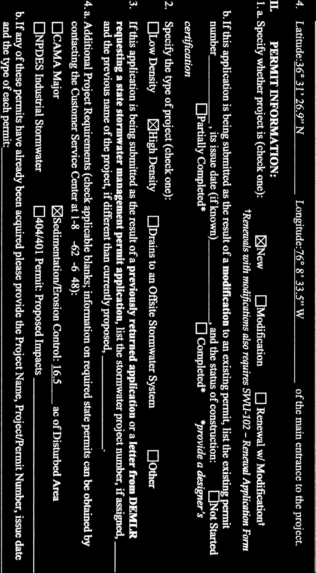
- Melissa Hunter
- 5 years ago
- Views:
Transcription


1


2


3


4
5
6
7


8
9
10


11
12


13


14
15
16


17


18

19


20


21


22
23

24

25

26

27
28


29


30


31


32
33
34
35
36


37
38


39


40


41


42

43

44

45


46


47
48 Table of Contents Project Description... 1 Summary of Existing Conditions... 1 Summary of Proposed Conditions... 1 Stormwater Compliance... 2 Collection... 2 Treatment... 3 Storage... 3 Disposal... 4 Soils... 4 Calculations... 4 Summary and Conclusions... 4 Appendices Appendix A Pre and Post Drainage Area Maps Appendix B - On-site Soils Report and Memo Appendix C State Stormwater Calculations Appendix D Currituck County Stormwater Calculations
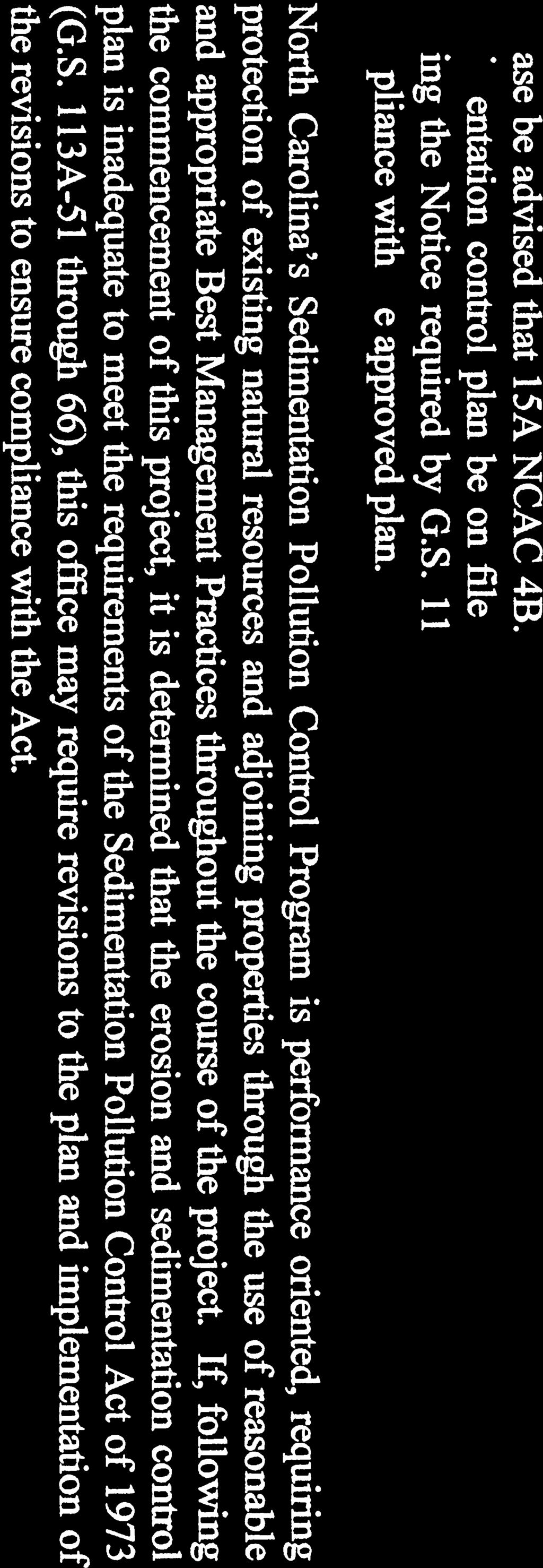
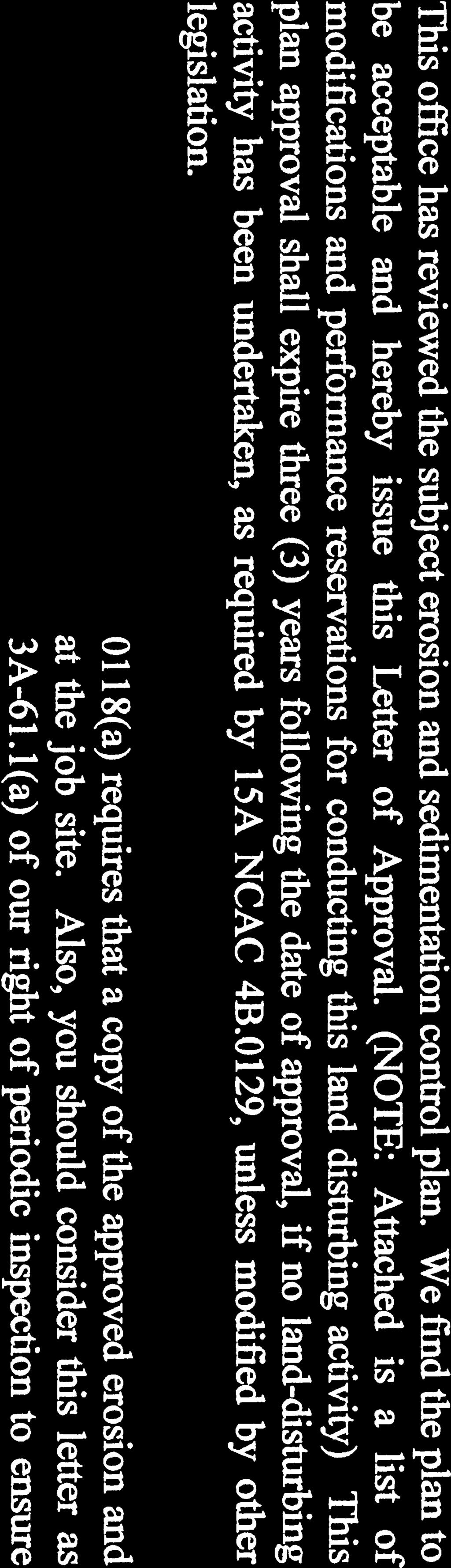
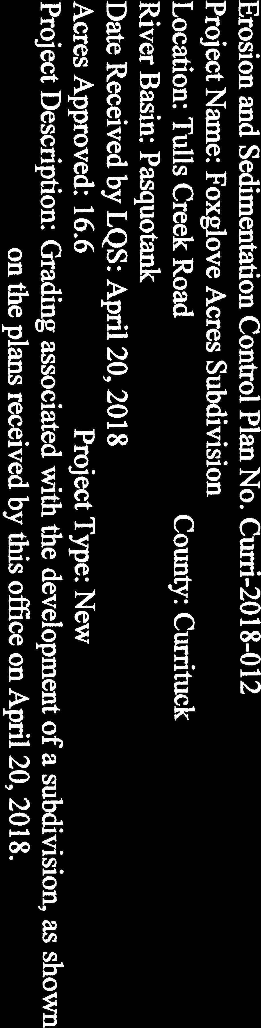
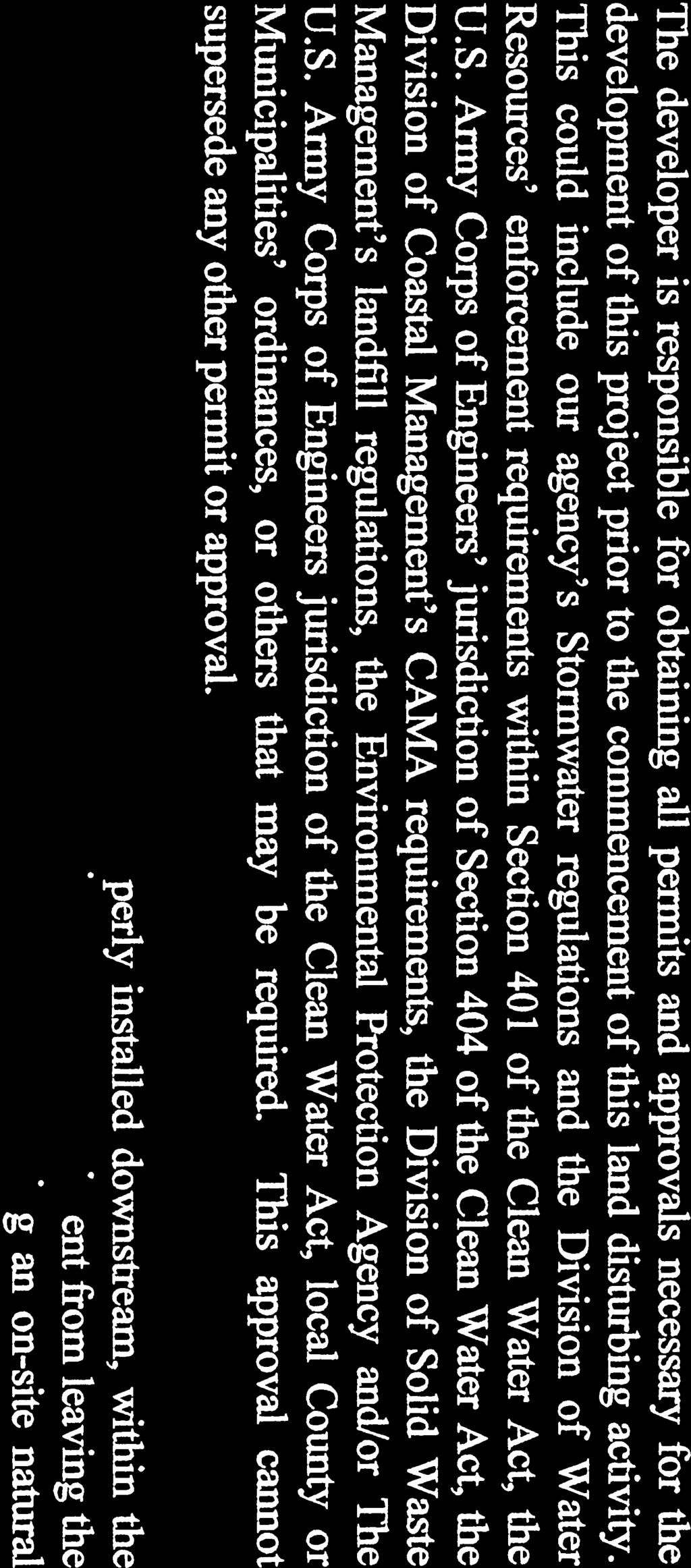
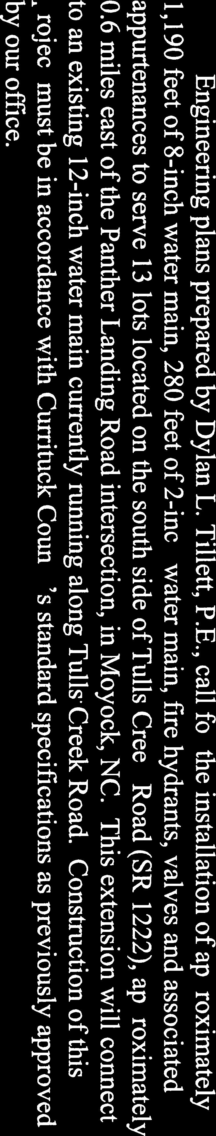
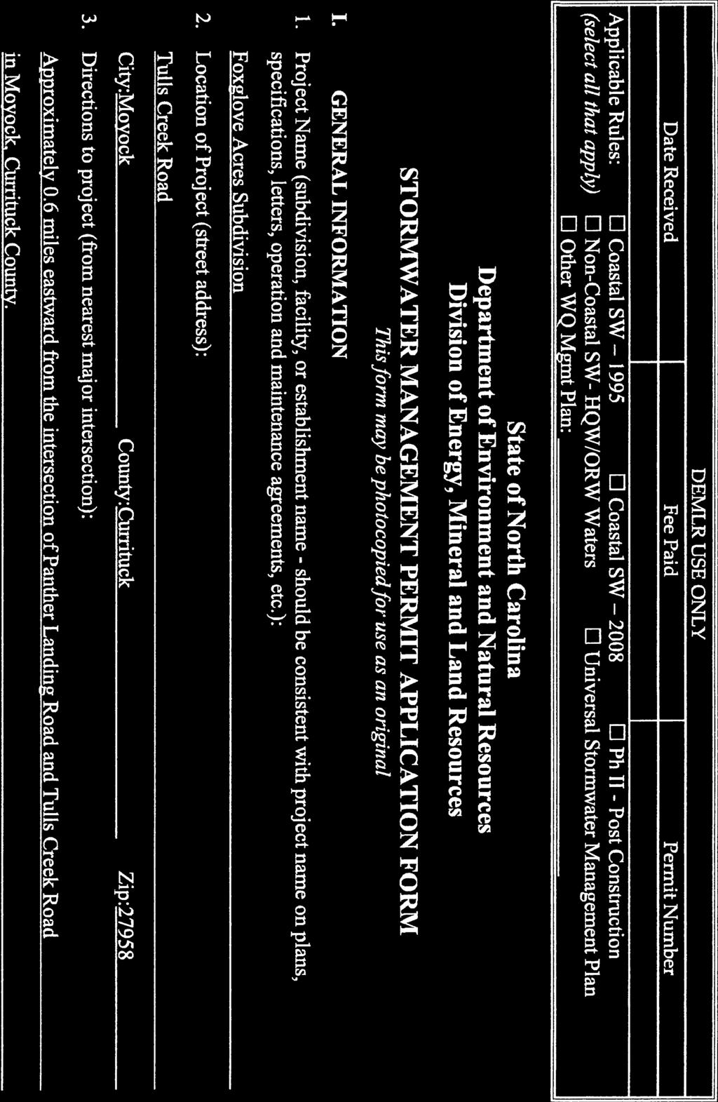
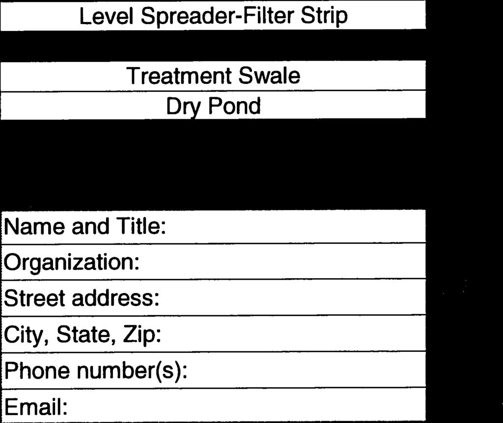
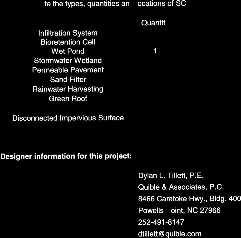
49 Project Description The following narrative will detail the stormwater management plan for the proposed Foxglove Acres subdivision located in Moyock, Currituck County, NC. The subject property is located along Tulls Creek Road, Moyock, NC approximately 0.6 miles eastward from the intersection of Panther Landing Road and Tulls Creek Road. The property is located along the southern side of Tulls Creek Road and previously known as Lots 1 & 2, Ward Acres Subdivision. The site development proposed the construction of a street, sidewalks, 13 residential lots, open space that includes stormwater control measures (SCM s) and associate utilities such as power, watermain, and fire hydrant assemblies. The project will also include two parking spaces (one of which will be a van accessible ADA space) and a cluster mailbox unit near the front of the subdivision. The following narrative, application, and calculations will demonstrate the parameters of the proposed subdivision design, which will illustrate an effective stormwater management system in compliance with all State regulations. Summary of Existing Conditions The existing acre project area is currently vacant and consists of agricultural fields and woods. There are three agricultural ditches that run through the project, a major drainage ditch that follows the southeastern property line and a roadside ditch along Tulls Creek Road. There are no wetlands within this project area. Existing ground elevations range between 5 to 8 with an average slope of 0.3%. Existing stormwater runoff is via sheet flow to the agricultural ditches that run through the properties. These ditches direct runoff to the major drainage ditch along the southeastern property line to Tulls Creek Road which then leaves the property eventually making it to the Northwest River. The site does not currently have any existing built upon area and only has one drainage area (DA 1). The boundary for DA 1 is provided within Appendix A on the Drainage Area Maps. Summary of Proposed Conditions The project proposes the construction of a street, sidewalk, 13 residential lots, open space that includes stormwater control measures (SCM s) and associated utilities such as power, watermain, and fire hydrant assemblies. The subdivision will propose 248,260 sq.ft. of coverage including a wet pond permanent pool area of 52,072 sq.ft. Upon completion of the proposed improvements, the sites overall BUA will be 34% of the drainage area. The proposed Built Upon Area (BUA) summary table can be seen on Table 2 below.
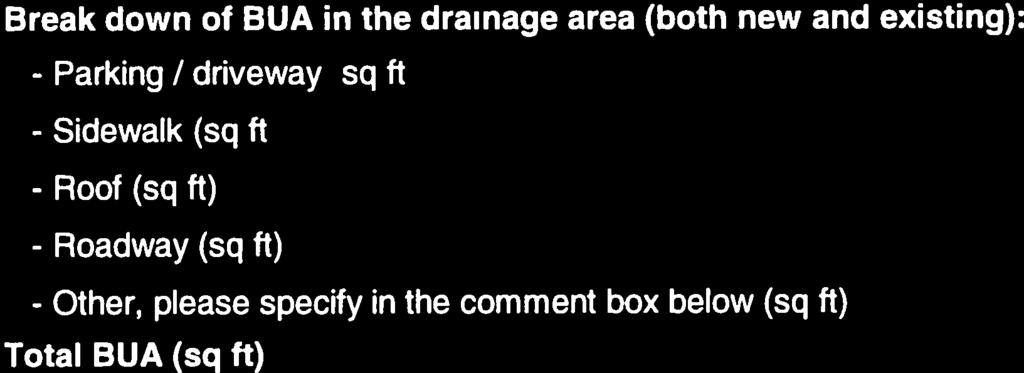
50 Table 2: Proposed Built Upon Area Summary Land Cover Description Drainage Basin 1 (sq.ft.) (acre) Drainage Area = 739, Open Space 491, Lot BUA = 161, Right of Way BUA = 33, Open Space BUA = Pond = 52, Total Impervious = 248, Stormwater management improvements will be provided to treat runoff from all proposed impervious construction. The primary method of stormwater treatment will be via a wet detention basin located on the northeastern of the site. The wet detention basin has been sized to manage an overall impervious area of 248,260 sq. ft. All of these impervious areas are located within Drainage Area 1 on the post-development drainage area map. Stormwater Compliance Per 15A NCAC 02H.1005 (a) (3) (B) High Density Coastal Development is required to meet particular criteria. This development is proposed to have 34% of impervious coverage within the entire lot. The proposed wet detention basin onsite is designed in accordance with NCDEQ and Currituck County Stormwater Manual Requirements and is designed to store, control, and treat the stormwater runoff from all surfaces generated by the one and one-half inch of rainfall event (State Requirements) and route the 10-year post-development back to the 2-year predevelopment, wooded conditions (Currituck County Requirements). In addition to these requirements, a minimum 50 vegetative buffer from surface waters is provided. The High Density Residential Subdivisions Deed Restrictions & Protective Covenances Form will be supplied with the State Stormwater Permit Application and will include the table below for allowable Built Upon Area for each lot: Lot # BUA (sf) Lot # BUA (sf) Lot # BUA (sf) Lot # BUA (sf) 1 15, , , , , , , , , , , , ,030 Collection Runoff from the proposed impervious area is to be collected and conveyed to the wet detention basin via sheet flow to the lot line / roadside vegetated swales. The vegetated swales will then deliver the runoff to the proposed forebay of the wet detention basin.
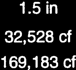
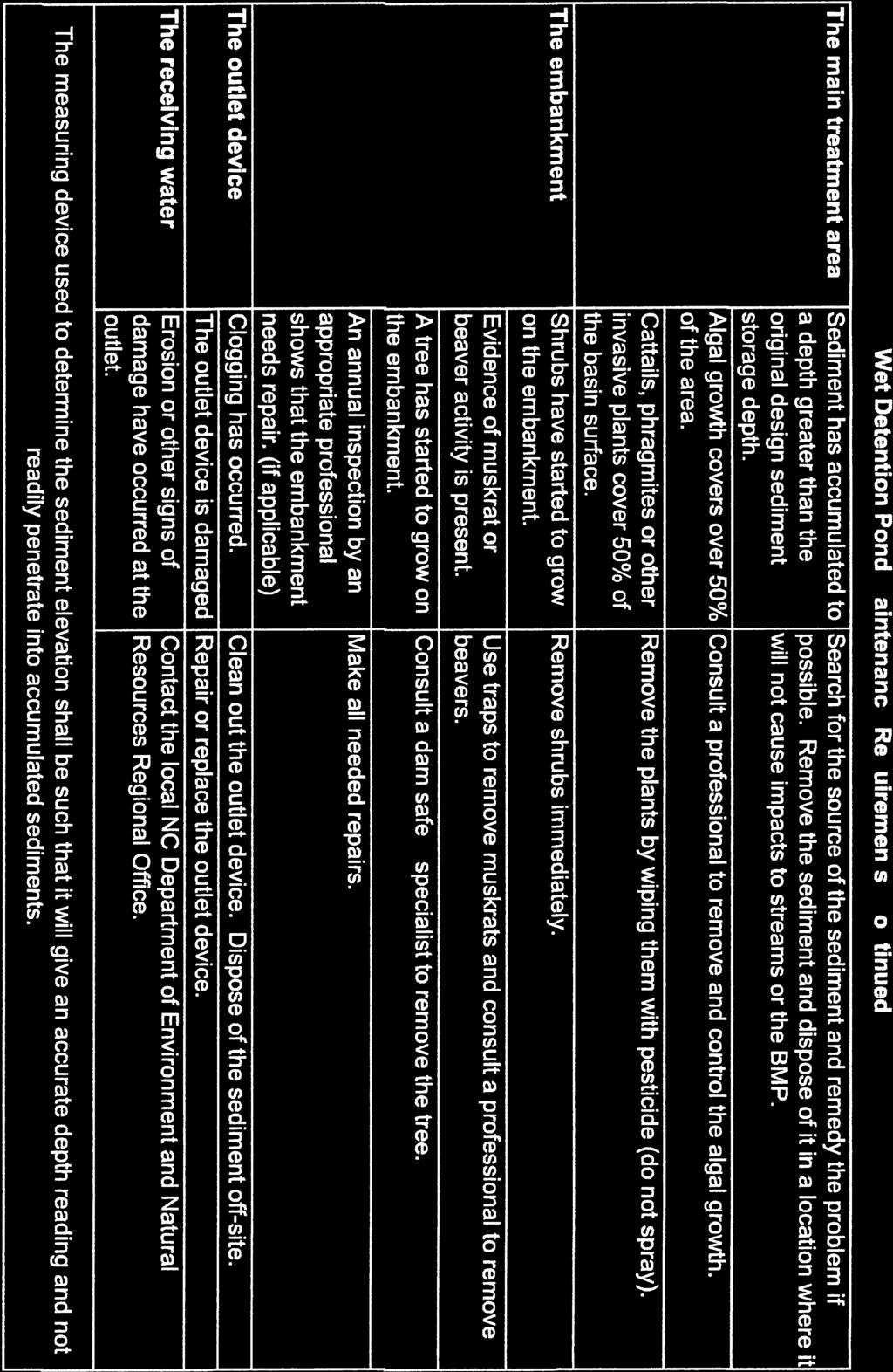
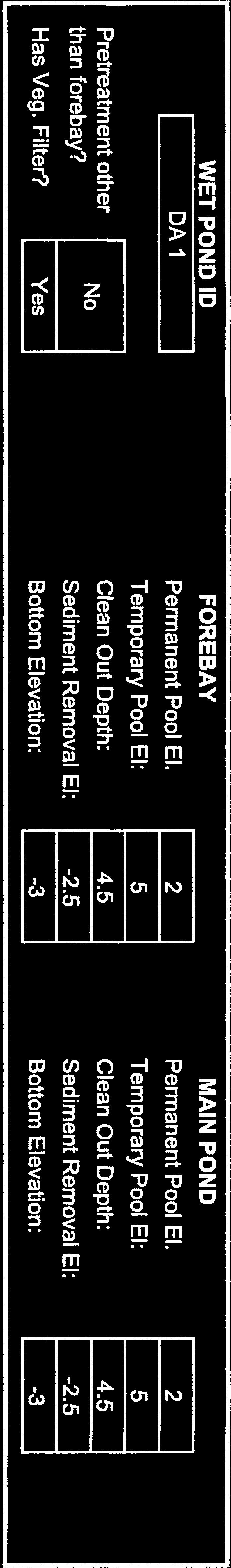
51 Treatment The proposed system will offer several methods of treatment prior to release. Runoff from the residential lots will be directed to the lot line swales and roadside swales via sheet flow. The vegetated swales will provide the first level of treatment by the filtration of small particulates and nutrients prior to entering the wet detention basin. Riprap will be provided at the inlet to the pond from the stormwater conveyance connections. Stormwater entering the forebay will be deenergized by the riprap as to reduce inflow velocities to the basin. Larger debris and pollutants will settle on the riprap aprons as the stormwater enters the forebay. The primary treatment of runoff will be provided within the wet detention basin. Several modes of treatment are available in the wet detention basin. Runoff first entering the basin will lose velocity and large particulates and sediment will settle out primarily in the forebay. The vegetated side slopes and vegetated shelf will also provide filtration of runoff and nutrient uptake through natural biological processes. Storage The proposed wet detention basin has been sized to allow for a local requirement of routing the 10-year post developed condition back to the 2-year pre developed wooded condition. This storage capacity is in excess of the State required 1.5 inch and provides approximately 7.8 inches of storage in the basin. The storage required to completely capture the first 1.5 inch of rainfall is 32,600 cubic feet. The proposed wet detention basin will have a temporary storage capacity of 169,183 cubic feet. The temporary storage capacity has been calculated between the permanent pool elevation of 2.0 and the overflow spillway invert at 5.0. For NCDEQ calculations, the anticipated permanent pool and surface areas referenced in the application documents and attached calculations are measured at 2.0 ft. in elevation. Utilizing permanent pool average depth equation 2 from Section C-3 Wet Pond in the NCDEQ Stormwater Design Manual, the average depth was calculated to be 4.3 feet. Table 2: Coastal SA/DA Table from this Manual using a 35% impervious area and a 4.0 foot depth states that the minimum surface area to drainage area percentage is 1.96% (linear interpolation). The proposed surface area to drainage area for this project is 5.82%, far exceeding the requirements. NCDEQ calculations are shown in Appendix C. As stated above, Currituck County Stormwater Manual requires the stormwater design to route the 10-year post-development storm back to the 2-year pre-development storm in wooded conditions. The peak runoff of the 10-year post-development storm is 51.8 cubic feet per second (cfs) and the peak runoff for the 2-year pre-development storm in wooded conditions is 16.3 cfs. The peak discharge from routing the 10-year post-development storm through the proposed stormwater detention basin is 12.9 cfs equating to less than the 2-year predevelopment storm in wooded conditions, thus satisfying the Currituck County Stormwater Manual. The Currituck County Stormwater Calculations are shown in Appendix D. The attached soils analysis memorandum in Appendix B states that the seasonal high water table (SHWT) was approximately 30 inches below the existing ground surface at SB-1 identified
52 on the Drainage Area Map. Existing grade at SB-1 was surveyed at 4.53 feet in elevation, which puts the SHWT at an elevation of 2.03 feet. A rounded elevation of 2.0 was used in the calculations for the SHWT. The basin s 6 foot wide, 6:1 (H:V) vegetated shelf is specified to be constructed between the elevations of 1.5 ft. and 2.5ft. Disposal The wet detention basin s primary mode of disposal for elevations between 2.0 and 4.0 ft. is through a 6 drawdown orifice on a structure located inside of the main pool. The invert elevation of the 6 drawdown orifice is proposed to be at an elevation of 2.0 ft. Elevations between 4.0 and 5.0 feet will utilize the 2.0 by 2.0 stormwater spillway structure with a trash rack on top as well as the 6 drawdown orifice. The invert elevation of the rim of the spillway structure is proposed to be 4.0 feet in elevation. The total drawdown time from an elevation of 5.0 ft. is 2.54 days. Supporting calculations for the drawdown time and storage of the proposed wet pond have been provided within Appendix C. Larger storms that will cause the wet pond to exceed the elevation of 5.0 ft. will overflow through the 10 wide, riprap-lined spillway into the downstream stormwater system. Soils The USDA NRCS Soil Survey lists the soil in the vicinity of the proposed stormwater detention basin as described below: Ro Roanoke fine sandy loam This soil typically has 0 to 2 percent slopes. Roanoke fine sandy loam has a very high runoff class and is poorly drained. This soil is categorized in Hydrologic Soil Group D. To Tomotley fine sandy loam This soil typically has 0 to 2 percent slopes. Tomotley fine sandy loam has a very high runoff class and is poorly drained. This soil is categorized in Hydrologic Soil Group D. Quible & Associates, P.C. conducted a soil boring test in the vicinity of the wet pond. The soils observed were consistent with the NRCS soil description. The results of this boring are available in Appendix B. Calculations A copy of the Drainage and Storage Calculations are provided in Appendix C and Appendix D of this narrative. Summary and Conclusions The proposed stormwater management plan for this site provides stormwater treatment in excess of the requirements for the State and Currituck County. The proposed system will offer primary and secondary methods of treatment. This proposed design will adequately serve the stormwater management requirements of the site.
53 Appendices
54 Appendix A - Pre- and Post-development On-site Drainage Area Maps
55 PRELIMINARY NOT FOR CONSTRUCTION

56 PRELIMINARY NOT FOR CONSTRUCTION
57 Appendix B - On-site Soils Map and Data

58 Soil Map Currituck County, North Carolina ' 52'' W ' 22'' W 36 31' 31'' N 36 31' 31'' N ' 16'' N ' 52'' W 76 8' 22'' W 36 31' 16'' N Soil Map may not be valid at this scale. N Map Scale: 1:3,360 if printed on A landscape (11" x 8.5") sheet. Meters Feet Map projection: Web Mercator Corner coordinates: WGS84 Edge tics: UTM Zone 18N WGS84 Natural Resources Conservation Service Web Soil Survey National Cooperative Soil Survey 9/28/2017 Page 1 of 3
59 MAP LEGEND MAP INFORMATION Soil Map Currituck County, North Carolina Area of Interest (AOI) Area of Interest (AOI) Soils Soil Map Unit Polygons Soil Map Unit Lines Soil Map Unit Points Special Point Features Blowout Borrow Pit Clay Spot Closed Depression Gravel Pit Gravelly Spot Landfill Lava Flow Marsh or swamp Mine or Quarry Miscellaneous Water Perennial Water Rock Outcrop Saline Spot Sandy Spot Severely Eroded Spot Sinkhole Slide or Slip Sodic Spot Spoil Area Stony Spot Very Stony Spot Wet Spot Other Special Line Features Water Features Streams and Canals Transportation Rails Interstate Highways US Routes Major Roads Local Roads Background Aerial Photography The soil surveys that comprise your AOI were mapped at 1:20,000. Warning: Soil Map may not be valid at this scale. Enlargement of maps beyond the scale of mapping can cause misunderstanding of the detail of mapping and accuracy of soil line placement. The maps do not show the small areas of contrasting soils that could have been shown at a more detailed scale. Please rely on the bar scale on each map sheet for map measurements. Source of Map: Natural Resources Conservation Service Web Soil Survey URL: Coordinate System: Web Mercator (EPSG:3857) Maps from the Web Soil Survey are based on the Web Mercator projection, which preserves direction and shape but distorts distance and area. A projection that preserves area, such as the Albers equal-area conic projection, should be used if more accurate calculations of distance or area are required. This product is generated from the USDA-NRCS certified data as of the version date(s) listed below. Soil Survey Area: Currituck County, North Carolina Survey Area Data: Version 15, Sep 19, 2016 Soil map units are labeled (as space allows) for map scales 1:50,000 or larger. Date(s) aerial images were photographed: Dec 31, 2009 Mar 8, 2017 The orthophoto or other base map on which the soil lines were compiled and digitized probably differs from the background imagery displayed on these maps. As a result, some minor shifting of map unit boundaries may be evident. Natural Resources Conservation Service Web Soil Survey National Cooperative Soil Survey 9/28/2017 Page 2 of 3
60 Soil Map Currituck County, North Carolina Map Unit Legend Currituck County, North Carolina (NC053) Map Unit Symbol Map Unit Name Acres in AOI Percent of AOI Ro Roanoke fine sandy loam % To Tomotley fine sandy loam % Totals for Area of Interest % Natural Resources Conservation Service Web Soil Survey National Cooperative Soil Survey 9/28/2017 Page 3 of 3
61 Map Unit Description: Roanoke fine sandy loam---currituck County, North Carolina Currituck County, North Carolina Ro Roanoke fine sandy loam Map Unit Setting National map unit symbol: 3rp1 Elevation: 0 to 20 feet Mean annual precipitation: 42 to 58 inches Mean annual air temperature: 61 to 64 degrees F Frost-free period: 190 to 270 days Farmland classification: Farmland of statewide importance Map Unit Composition Roanoke, drained, and similar soils: 80 percent Roanoke, undrained, and similar soils: 10 percent Estimates are based on observations, descriptions, and transects of the mapunit. Description of Roanoke, Drained Setting Landform: Depressions on marine terraces, flats on marine terraces Down-slope shape: Linear Across-slope shape: Linear Parent material: Clayey marine deposits and/or fluviomarine deposits Typical profile Ap - 0 to 8 inches: silt loam Btg - 8 to 58 inches: clay Cg - 58 to 80 inches: fine sand Properties and qualities Slope: 0 to 2 percent Depth to restrictive feature: More than 80 inches Natural drainage class: Poorly drained Runoff class: Very high Capacity of the most limiting layer to transmit water (Ksat): Very low to moderately high (0.00 to 0.20 in/hr) Depth to water table: About 0 to 12 inches Frequency of flooding: Rare Frequency of ponding: None Available water storage in profile: High (about 9.0 inches) Interpretive groups Land capability classification (irrigated): None specified Land capability classification (nonirrigated): 3w Hydrologic Soil Group: C/D Hydric soil rating: Yes Natural Resources Conservation Service Web Soil Survey National Cooperative Soil Survey 9/6/2017 Page 1 of 2
62 Map Unit Description: Roanoke fine sandy loam---currituck County, North Carolina Description of Roanoke, Undrained Setting Landform: Depressions on marine terraces, flats on marine terraces Down-slope shape: Linear Across-slope shape: Linear Parent material: Clayey marine deposits and/or fluviomarine deposits Typical profile A - 0 to 8 inches: silt loam Btg - 8 to 58 inches: clay Cg - 58 to 80 inches: fine sand Properties and qualities Slope: 0 to 2 percent Depth to restrictive feature: More than 80 inches Natural drainage class: Poorly drained Runoff class: Very high Capacity of the most limiting layer to transmit water (Ksat): Very low to moderately high (0.00 to 0.20 in/hr) Depth to water table: About 0 to 12 inches Frequency of flooding: Rare Frequency of ponding: None Available water storage in profile: High (about 9.0 inches) Interpretive groups Land capability classification (irrigated): None specified Land capability classification (nonirrigated): 4w Hydrologic Soil Group: C/D Hydric soil rating: Yes Data Source Information Soil Survey Area: Currituck County, North Carolina Survey Area Data: Version 15, Sep 19, 2016 Natural Resources Conservation Service Web Soil Survey National Cooperative Soil Survey 9/6/2017 Page 2 of 2
63 Map Unit Description: Tomotley fine sandy loam---currituck County, North Carolina Currituck County, North Carolina To Tomotley fine sandy loam Map Unit Setting National map unit symbol: 3rp4 Elevation: 0 to 30 feet Mean annual precipitation: 42 to 58 inches Mean annual air temperature: 61 to 64 degrees F Frost-free period: 190 to 270 days Farmland classification: Prime farmland if drained Map Unit Composition Tomotley, drained, and similar soils: 75 percent Tomotley, undrained, and similar soils: 10 percent Minor components: 6 percent Estimates are based on observations, descriptions, and transects of the mapunit. Description of Tomotley, Drained Setting Landform: Depressions on stream terraces, flats on marine terraces Down-slope shape: Linear Across-slope shape: Linear Parent material: Sandy and loamy fluviomarine deposits and/or marine deposits Typical profile Ap - 0 to 7 inches: fine sandy loam Btg1-7 to 12 inches: fine sandy loam Btg2-12 to 42 inches: sandy clay loam BCg - 42 to 50 inches: sandy loam Cg - 50 to 80 inches: loamy sand Properties and qualities Slope: 0 to 2 percent Depth to restrictive feature: More than 80 inches Natural drainage class: Poorly drained Runoff class: Very high Capacity of the most limiting layer to transmit water (Ksat): Moderately high to high (0.20 to 1.98 in/hr) Depth to water table: About 0 to 12 inches Frequency of flooding: None Frequency of ponding: None Available water storage in profile: Moderate (about 8.1 inches) Interpretive groups Land capability classification (irrigated): None specified Land capability classification (nonirrigated): 3w Hydrologic Soil Group: B/D Natural Resources Conservation Service Web Soil Survey National Cooperative Soil Survey 9/6/2017 Page 1 of 3
64 Map Unit Description: Tomotley fine sandy loam---currituck County, North Carolina Hydric soil rating: Yes Description of Tomotley, Undrained Setting Landform: Depressions on stream terraces, flats on marine terraces Down-slope shape: Linear Across-slope shape: Linear Parent material: Sandy and loamy fluviomarine deposits and/or marine deposits Typical profile A - 0 to 7 inches: fine sandy loam Btg1-7 to 12 inches: fine sandy loam Btg2-12 to 42 inches: sandy clay loam BCg - 42 to 50 inches: sandy loam Cg - 50 to 80 inches: loamy sand Properties and qualities Slope: 0 to 2 percent Depth to restrictive feature: More than 80 inches Natural drainage class: Poorly drained Runoff class: Very high Capacity of the most limiting layer to transmit water (Ksat): Moderately high to high (0.20 to 1.98 in/hr) Depth to water table: About 0 to 12 inches Frequency of flooding: None Frequency of ponding: None Available water storage in profile: Moderate (about 8.1 inches) Interpretive groups Land capability classification (irrigated): None specified Land capability classification (nonirrigated): 4w Hydrologic Soil Group: B/D Hydric soil rating: Yes Minor Components Nimmo, undrained Percent of map unit: 3 percent Landform: Depressions on marine terraces, flats on marine terraces Down-slope shape: Concave Across-slope shape: Linear Hydric soil rating: Yes Arapahoe, undrained Percent of map unit: 3 percent Landform: Depressions, flats Down-slope shape: Linear Across-slope shape: Concave Hydric soil rating: Yes Natural Resources Conservation Service Web Soil Survey National Cooperative Soil Survey 9/6/2017 Page 2 of 3
65 Map Unit Description: Tomotley fine sandy loam---currituck County, North Carolina Dragston, undrained Percent of map unit: 0 percent Landform: Marine terraces Down-slope shape: Linear Across-slope shape: Linear Hydric soil rating: No Data Source Information Soil Survey Area: Currituck County, North Carolina Survey Area Data: Version 15, Sep 19, 2016 Natural Resources Conservation Service Web Soil Survey National Cooperative Soil Survey 9/6/2017 Page 3 of 3
66
67 Appendix C - State Stormwater Calculations
68 NCDEQ Stormwater Calculations Foxglove Acres Subdivision Moyock, Currituck County, North Carolina Drainage Area Calculations Drainage Basin A (sq.ft.) (acre) Drainage Area = 739, Open Space 491, Lot BUA = 161, Right of Way BUA = 33, Open Space BUA = Pond = 52, Total Impervious = 248, Runoff generated by 1.5" Rainfall Event (NCDEQ Simplified Method) Ia = Impervious Percentage = Impervious Area/Drainage Area Rv= Runoff Coefficient, Ia Rd= Rain fall depth (1.5 in.) V= Runoff Volume, 3630*Rd*Rv*A Area 1 Ia = 33.6% Rv= 0.35 Rd (in.)= 1.5 A (ac.) = V (cf.)= 32,528 Total Storage Required by NCDEQ = 32, cf Permanent Pool Volume Provided In Wet Detention Basin 1 Volume Elev Area (sf) Avg area (sf) (cf) Cum Vol. (cf) l Permanent Pool Storage (cf.) Provided in Basin 1: 185,760
69 Storage Above Permanent Pool for Basin 1 Elev Area (sf) Avg area (sf) Volume (cf) Cum Vol. (cf) Total Storage (cf.) Provided in Basin 1: Rainfall Equavalent: 169, in Volume in Forebay for Basin 1 Elev Area (sf) Avg area (sf) Volume Cum Vol. (cf) (cf) Total Storage (cf.) Provided in Forebay for Basin 1: 32, % A bot_shelf = sf (1.5') A perm_pool =42991 sf (2.0') A bot_pond = sf (-3.0' Main Pool only) V perm_pool = cf (2.0') Depth = 5 ft Main Pool Volume Req'd Option 1 Dav = 4.3 feet Option 2 Dav = 4.7 feet Percent Impervious Coverage: 33.6% Surface area of mainbay sf Drainage area SA/DA 5.82% Min. per Table % OK (for 35% 4.0' depth)
70 Orifice Drawdown Calculations Stage 5.0' to 4.0' Orifice Outlet Equation Q = C D A(2gH o ) 0.5 C D = 0.6 Orifice Diameter = 0.5 ft. Orifice Area, A = 0.20 sq.ft. H o = 3.25 ft. H o /3 = Q = Volume = Drawdown Time = Weir Structure EquationQ = C w LH ft cfs 61,252 cf sec days C w = 0.30 L = 8.00 ft. (2.0' x 2.0' Grate) H = 1.00 ft. Q = 2.40 cfs Volume = cf. Drawdown Time = sec days Stage 4.0' to 2.0' Orifice Outlet Equation Q = C D A(2gH o ) 0.5 C D = 0.6 Orifice Diameter = 0.5 ft. Orifice Area, A = 0.20 sq.ft. H o = 2.25 ft. H o /3 = Q = Volume = Drawdown Time = 0.75 ft cfs 107,931 cf sec days Total Drawdown Time 2.54 days
71 Appendix D Currituck County Stormwater Calculations
72 Watershed Model Schematic Hydraflow Hydrographs Extension for AutoCAD Civil 3D 2018 by Autodesk, Inc. v Legend Hyd. Origin Description 1 SCS Runoff P Post-Development 2 SCS Runoff Pre-Development 3 Reservoir Wet Pond Routing Project: P Currituck County Stormwater Model.gpw Wednesday, 06 / 27 / 2018
73 Hydrograph Summary Report Hydraflow Hydrographs Extension for AutoCAD Civil 3D 2018 by Autodesk, Inc. v12 Hyd. Hydrograph Peak Time Time to Hyd. Inflow Maximum Total Hydrograph No. type flow interval Peak volume hyd(s) elevation strge used Description (origin) (cfs) (min) (min) (cuft) (ft) (cuft) 1 SCS Runoff , P Post-Development 2 SCS Runoff , Pre-Development 3 Reservoir , ,975 Wet Pond Routing P Currituck County Stormwater Model.gpw Return Period: 2 Year Wednesday, 06 / 27 / 2018
74 Hydrograph Report Hydraflow Hydrographs Extension for AutoCAD Civil 3D 2018 by Autodesk, Inc. v12 Wednesday, 06 / 27 / 2018 Hyd. No. 2 Pre-Development Hydrograph type = SCS Runoff Peak discharge = cfs Storm frequency = 2 yrs Time to peak = hrs Time interval = 2 min Hyd. volume = 111,618 cuft Drainage area = ac Curve number = 77 Basin Slope = 0.0 % Hydraulic length = 0 ft Tc method = TR55 Time of conc. (Tc) = min Total precip. = 4.00 in Distribution = Type III Storm duration = 24 hrs Shape factor = 484 Q (cfs) Pre-Development Hyd. No Year Q (cfs) Time (hrs) Hyd No. 2
75 TR55 Tc Worksheet Hydraflow Hydrographs Extension for AutoCAD Civil 3D 2018 by Autodesk, Inc. v12 Hyd. No. 2 Pre-Development Description A B C Totals Sheet Flow Manning's n-value = Flow length (ft) = Two-year 24-hr precip. (in) = Land slope (%) = Travel Time (min) = = Shallow Concentrated Flow Flow length (ft) = Watercourse slope (%) = Surface description = Unpaved Paved Paved Average velocity (ft/s) = Travel Time (min) = = 3.73 Channel Flow X sectional flow area (sqft) = Wetted perimeter (ft) = Channel slope (%) = Manning's n-value = Velocity (ft/s) = Flow length (ft) ({0}) Travel Time (min) = = Total Travel Time, Tc min
76 Hydrograph Summary Report Hydraflow Hydrographs Extension for AutoCAD Civil 3D 2018 by Autodesk, Inc. v12 Hyd. Hydrograph Peak Time Time to Hyd. Inflow Maximum Total Hydrograph No. type flow interval Peak volume hyd(s) elevation strge used Description (origin) (cfs) (min) (min) (cuft) (ft) (cuft) 1 SCS Runoff , P Post-Development 2 SCS Runoff , Pre-Development 3 Reservoir , ,631 Wet Pond Routing P Currituck County Stormwater Model.gpw Return Period: 10 Year Wednesday, 06 / 27 / 2018
77 Hydrograph Report Hydraflow Hydrographs Extension for AutoCAD Civil 3D 2018 by Autodesk, Inc. v12 Wednesday, 06 / 27 / 2018 Hyd. No. 1 P Post-Development Hydrograph type = SCS Runoff Peak discharge = cfs Storm frequency = 10 yrs Time to peak = hrs Time interval = 2 min Hyd. volume = 295,354 cuft Drainage area = ac Curve number = 89 Basin Slope = 0.0 % Hydraulic length = 0 ft Tc method = TR55 Time of conc. (Tc) = min Total precip. = 6.00 in Distribution = Type III Storm duration = 24 hrs Shape factor = 484 Q (cfs) P Post-Development Hyd. No Year Q (cfs) Time (hrs) Hyd No. 1
78 TR55 Tc Worksheet Hydraflow Hydrographs Extension for AutoCAD Civil 3D 2018 by Autodesk, Inc. v12 Hyd. No. 1 P Post-Development Description A B C Totals Sheet Flow Manning's n-value = Flow length (ft) = Two-year 24-hr precip. (in) = Land slope (%) = Travel Time (min) = = Shallow Concentrated Flow Flow length (ft) = Watercourse slope (%) = Surface description = Unpaved Paved Paved Average velocity (ft/s) = Travel Time (min) = = 3.36 Channel Flow X sectional flow area (sqft) = Wetted perimeter (ft) = Channel slope (%) = Manning's n-value = Velocity (ft/s) = Flow length (ft) ({0}) Travel Time (min) = = 7.92 Total Travel Time, Tc min
79 Hydrograph Report Hydraflow Hydrographs Extension for AutoCAD Civil 3D 2018 by Autodesk, Inc. v12 Wednesday, 06 / 27 / 2018 Hyd. No. 3 Wet Pond Routing Hydrograph type = Reservoir Peak discharge = cfs Storm frequency = 10 yrs Time to peak = hrs Time interval = 2 min Hyd. volume = 290,266 cuft Inflow hyd. No. = 1 - P Post-DevelopmentMax. Elevation = ft Reservoir name = Wet Pond Max. Storage = 380,631 cuft Storage Indication method used. Wet pond routing start elevation = ft. Q (cfs) Wet Pond Routing Hyd. No Year Q (cfs) Time (hrs) Hyd No. 3 Hyd No. 1 Total storage used = 380,631 cuft
80 Hydraflow Rainfall Report Hydraflow Hydrographs Extension for AutoCAD Civil 3D 2018 by Autodesk, Inc. v12 Wednesday, 06 / 27 / 2018 Return Intensity-Duration-Frequency Equation Coefficients (FHA) Period (Yrs) B D E (N/A) File name: SampleFHA.idf Intensity = B / (Tc + D)^E Return Intensity Values (in/hr) Period (Yrs) 5 min Tc = time in minutes. Values may exceed 60. Precip. file name: Q:\2017\P17088\Documents\County Stormwater\P Moyock Rainfall Data.pcp Rainfall Precipitation Table (in) Storm Distribution 1-yr 2-yr 3-yr 5-yr 10-yr 25-yr 50-yr 100-yr SCS 24-hour SCS 6-Hr Huff-1st Huff-2nd Huff-3rd Huff-4th Huff-Indy Custom
81
Soil Map Boulder County Area, Colorado (Planet Blue Grass) Web Soil Survey National Cooperative Soil Survey
 Web Soil Survey National Cooperative Soil Survey") 475910 476000 476090 476180 476270 476360 105 16' 21'' W 476450 476540 476630 476720 476810 4453350 4453440 4453260 4453350 4453170 4453260 4453080 4453170 4453080 475820 475910 4452990 476000 476090 476180
475910 476000 476090 476180 476270 476360 105 16' 21'' W 476450 476540 476630 476720 476810 4453350 4453440 4453260 4453350 4453170 4453260 4453080 4453170 4453080 475820 475910 4452990 476000 476090 476180
Custom Soil Resource Report for Forrest County, Mississippi
 United States Department of Agriculture Natural Resources Conservation Service A product of the National Cooperative Soil Survey, a joint effort of the United States Department of Agriculture and other
Custom Soil Resource Report Soil Map
 121 3' 56'' W Custom Soil Resource Report Soil Map 121 2' 49'' W 45 16' 39'' N 5013800 5014000 5014200 5014400 5014600 5014800 5015000 5015200 5015400 5015600 651800 652000 652200 652400 652600 652800
Custom Soil Resource Report for Victoria County, Texas
 United States Department of Agriculture Natural Resources Conservation Service A product of the National Cooperative Soil Survey, a joint effort of the United States Department of Agriculture and other
Custom Soil Resource Report. Soil Map. Map projection: Web Mercator Corner coordinates: WGS84 Edge tics: UTM Zone 14N WGS84. Feet.
 Custom Soil Resource Report Soil Map 3188500 3188700 3188900 3189100 3189300 3189500 3189700 96 43' 30'' W 3188500 3188700 3188900 3189100 3189300 3189500 3189700 96 42' 11'' W 28 48' 59'' N 28 48' 59''
Soil Map Polk County, Florida
 Soil Map Polk County, Florida 28 9' 21'' 28 8' 23'' 3113000 3113200 3113400 3113600 3113800 3114000 3114200 3114400 3114600 81 51' 19'' 81 51' 19'' 416000 416000 ± 416200 416200 68 416400 68 416400 7 13
Custom Soil Resource Report Soil Map
 78 10' 44'' W Custom Soil Resource Report Soil Map 78 9' 40'' W 40 37' 18'' N 738700 738800 738900 739000 739100 739200 739300 739400 739500 739600 739700 739800 739900 740000 740100 40 37' 18'' N 4499700
CRUM RANCH AREA MAP YOLO COUNTY, California, AC +/-
 CRUM RANCH AREA MAP YOLO COUNTY, California, 235.59 AC +/- Map data 2016 Google Imagery 2016, CAPCOG, DigitalGlobe, Texas Orthoimagery Program, U.S. Geological Survey, USDA Farm Service Agency Boundary
RANCHO de DOS PALMAS DAVIS, California, AC +/-
 RANCHO de DOS PALMAS DAVIS, California, 507.28 AC +/- Boundary Transmission Line Pond / Tank Well SCOTT STONE P: (530) 662-4094 sastone57@gmail.com 37874 County Road 28, Woodland, Ca. 95695 The information
Custom Soil Resource Report for Clackamas County Area, Oregon
 United States Department of Agriculture Natural Resources Conservation Service A product of the National Cooperative Soil Survey, a joint effort of the United States Department of Agriculture and other
T his map is for illus trative purpos es only and does not repres ent a s urvey. I t is provided 'as is ' without warranty or any repres entation of
 http://montgomerytx.mygisonline.com/print/?extent=2988061.71355584,14087737.6935746,299... 3/2/2017 10:41 AM 20 Montgomery CAD, TX Date Printed: 3 /2 /2017 T his map is for illus trative purpos es only
CALIFORNIA AGRICULTURAL PR OPERTIES, IN C. GALE RANCH
 CALIFORNIA AGRICULTURAL PR OPERTIES, IN C. GALE RANCH LOCATION: The Ranch is located 6 Yi miles west of the City of Davis on the northwest corner of County Roads 29A and 92E in Yolo County. SIZE: 368.64
BUNCOMBE COUNTY NORTH CAROLINA
 PROJECT SITE ² 0 0. 75 1. 5 LOCATION MAP MARCH 2018 2. 25 3 Mil es AID: PROJECT # 2018-01122 18.05301 Sheet 1 of 7 Sources: Esri, HERE, DeLorme, USGS, Intermap, INCREMENT P, NRCan, Esri Japan, METI, Esri
FOR SALE. Features Rives Road Petersburg, Virginia Chris Jenkins
 FOR SALE 3513 Rives Road Petersburg, Virginia 23805 Chris Jenkins T 804-228-4928 E cjenkins@ commonwealthcommercial.com Bill Barnett T 804-433-1821 E bbarnett@ commonwealthcommercial.com Features 142±
Custom Soil Resource Report for Clackamas County Area, Oregon
 United States Department of Agriculture Natural Resources Conservation Service A product of the National Cooperative Soil Survey, a joint effort of the United States Department of Agriculture and other
Aqua Dome Express Car Wash
 Aqua Dome Express Car Wash Stormwater Design Calculations Prepared by: 6997 Professional Parkway East, Suite B Lakewood Ranch, Florida 34240 (941) 444-6644 www.morrisengineering.net Prepared for: Florida
Custom Soil Resource Report for Multnomah County Area, Oregon
 United States Department of Agriculture Natural Resources Conservation Service A product of the National Cooperative Soil Survey, a joint effort of the United States Department of Agriculture and other
Hydric Rating by Map Unit Harrison County, Mississippi. Web Soil Survey National Cooperative Soil Survey
 89 9' 7'' W 89 8' 38'' W 30 34' 13'' N 30 33' 57'' N 3383480 3383560 3383640 3383720 3383800 3383880 3383960 293640 293720 293800 293880 293960 294040 294120 294200 294280 294360 3383480 3383560 3383640
Custom Soil Resource Report for Valley County, Montana
 United States Department of Agriculture Natural Resources Conservation Service A product of the National Cooperative Soil Survey, a joint effort of the United States Department of Agriculture and other
Exhibit RMP-4. Foote Creek Geology and Topography
 Exhibit RMP-4 Foote Creek Geology and Topography Memorandum To: From: CC: Travis Brown, PacifiCorp Daria Drago, P.E., PMP Dr. Deb Luchsinger Date: January 9, 2019 Re: Foote Creek Rim 1 - Geologic Conditions
Hydric Rating by Map Unit Harrison County, Mississippi
 89 6' 12'' W 89 5' 54'' W 30 28' 47'' N 30 28' 26'' N 3373210 3373290 3373370 3373450 3373530 3373610 3373690 3373770 3373850 298080 298160 298240 298320 298400 298480 298560 30 28' 47'' N Soil Map may
Custom Soil Resource Report for St. Lucie County, Florida
 United States Department of Agriculture Natural Resources Conservation Service A product of the National Cooperative Soil Survey, a joint effort of the United States Department of Agriculture and other
STREUVER FIDELCO CAPPELLI, LLC YONKERS DOWNTOWN DEVELOPMENT PHASE 1. DRAFT ENVIRONMENTAL IMPACT STATEMENT For: PALISADES POINT
 STREUVER FIDELCO CAPPELLI, LLC YONKERS DOWNTOWN DEVELOPMENT PHASE 1 DRAFT ENVIRONMENTAL IMPACT STATEMENT For: PALISADES POINT Prepared by: PAULUS, SOKOLOWSKI & SARTOR STORMWATER MANAGEMENT 1. Methodology
Hydric Rating by Map Unit Ocean County, New Jersey (Larsen & N New Prospect Jackson Twp., NJ)
") 74 16' 14'' W Hydric Rating by Map Unit Ocean County, New Jersey ( ) 74 15' 50'' W 40 9' 17'' N 40 8' 53'' N 4444460 4444550 4444640 4444730 4444820 4444910 4445000 4445090 4445180 562120 562210 562300
74 16' 14'' W Hydric Rating by Map Unit Ocean County, New Jersey ( ) 74 15' 50'' W 40 9' 17'' N 40 8' 53'' N 4444460 4444550 4444640 4444730 4444820 4444910 4445000 4445090 4445180 562120 562210 562300
Using the Web Soil Survey Resilience and Resistance Score Sheet Soils Report
 Using the Resilience and Resistance Score Sheet Soils Report 1. Go to http://websoilsurvey.nrcs.usda.gov/app/ and click on the Start WSS button. 2. Create an Area of Interest (AOI) using any of the available
SINCE 1959 SITE NARRATIVE Major Site Plan Application Lot 18 Harbinger Park Powells Point, Currituck County, North Carolina Prepared For: Richard M No
 SINCE 1959 SITE NARRATIVE Major Site Plan Application Lot 18 Harbinger Park Powells Point, Currituck County, North Carolina Prepared For: Richard M Norris & Brooke R Norris 101 Baker Ave. Kill Devil Hills,
Appendix 2b. NRCS Soil Survey
 Appendix 2b NRCS Soil Survey 118 19' 25'' W Nonirrigated Capability Class Antelope Valley Area, California (Del Sur Solar Site) 118 17' 28'' W 378900 379200 379500 379800 380100 380400 380700 381000 381300
Web Soil Survey National Cooperative Soil Survey
 121 52' 18'' W Irrigated Capability Class Sutter County, California () 121 51' 49'' W 597600 597700 597800 597900 598000 598100 598200 39 6' 27'' N 39 6' 27'' N 39 5' 57'' N 4328400 4328500 4328600 4328700
PARADIGM ODP FORT COLLINS, CO 80525
 DRAINAGE REPORT PARADIGM ODP FORT COLLINS, CO 80525 Prepared For: Paradigm Properties, LLC 2186 Knoll Drive Ventura, CA 93003 Prepared By Coffey Engineering & Surveying 4045 St. Cloud Drive, Suite 180
Web Soil Survey National Cooperative Soil Survey
 122 14' 27'' W () 122 13' 37'' W 40 8' 40'' N 564700 564800 564900 565000 565100 565200 565300 565400 565500 565600 565700 565800 40 8' 40'' N 4443400 4443500 4443600 4443700 4443800 4443900 4444000 4443400
Web Soil Survey National Cooperative Soil Survey
 252500 252600 252700 252800 252900 253000 253100 83 47' 15'' W 83 47' 49'' W Nonirrigated Capability Class Jackson and Owsley Counties, Kentucky (Peggy Wilson Booneville Property - ) 253200 253300 37 25'
Custom Soil Resource Report for Columbus County, North Carolina
 United States Department of Agriculture Natural Resources Conservation Service A product of the National Cooperative Soil Survey, a joint effort of the United States Department of Agriculture and other
CALIFORNIA AGRICULTURAL PR OPERTIES, IN C. BOWLSBEY 320 LIBERTY ISLAND ROAD BUYER: RASSMUSSEN TRUST
 CALIFORNIA AGRICULTURAL PR OPERTIES, IN C. BOWLSBEY 320 LIBERTY ISLAND ROAD SELLER: BOWLSBEY TRUST BUYER: RASSMUSSEN TRUST LOCATION: The Bowlsbey 320 is located ten (10) miles southeast of the City of
TRACT 7: ±252 Acres Irrigated Farmland Grassland
 TRACT 7: ±252 Acres Irrigated Farmland Grassland 1880 FM 2013, Friona, Texas 79035 ±252 acres of irrigated farmland and grassland. This farmland is currently being leased and farmed. The lease agreement
Custom Soil Resource Report for Bell County, Texas
 United States Department of Agriculture Natural Resources Conservation Service A product of the National Cooperative Soil Survey, a joint effort of the United States Department of Agriculture and other
Custom Soil Resource Report for Polk County, Oregon
 United States Department of Agriculture Natural Resources Conservation Service A product of the National Cooperative Soil Survey, a joint effort of the United States Department of Agriculture and other
Custom Soil Resource Report for Island County, Washington
 United States Department of Agriculture Natural Resources Conservation Service A product of the National Cooperative Soil Survey, a joint effort of the United States Department of Agriculture and other
Wright County, MN. Overview. Legend
 Wright County, MN Overview 461 ft Legend Roads CSAHCL CTYCL MUNICL PRIVATECL TWPCL Highways Interstate State Hwy US Hwy City/Township Limits c t Subdivisions Parcels Water 2' Contours 842; 844; 846; 848;
Custom Soil Resource Report for Southampton County, Virginia
 United States Department of Agriculture Natural Resources Conservation Service A product of the National Cooperative Soil Survey, a joint effort of the United States Department of Agriculture and other
Hydric Rating by Map Unit Harrison County, Mississippi 30 27' 27'' 30 26' 57''
 Hydric Rating by Map Unit Harrison County, Mississippi 30 27' 27'' 30 26' 57'' 3370400 3370500 3370600 3370700 3370800 3370900 3371000 3371100 3371200 89 2' 40'' 89 2' 41'' 303700 303700 303800 303800
Custom Soil Resource Report for Missoula County Area, Montana
 United States Department of Agriculture Natural Resources Conservation Service A product of the National Cooperative Soil Survey, a joint effort of the United States Department of Agriculture and other
Custom Soil Resource Report for Clackamas County Area, Oregon, and Marion County Area, Oregon
 United States Department of Agriculture Natural Resources Conservation Service A product of the National Cooperative Soil Survey, a joint effort of the United States Department of Agriculture and other
Custom Soil Resource Report for Wright County, Minnesota
 United States Department of Agriculture Natural Resources Conservation Service A product of the National Cooperative Soil Survey, a joint effort of the United States Department of Agriculture and other
Custom Soil Resource Report for Cuyahoga County, Ohio
 United States Department of Agriculture Natural Resources Conservation Service A product of the National Cooperative Soil Survey, a joint effort of the United States Department of Agriculture and other
Custom Soil Resource Report Soil Map
 77 35' 22'' W Custom Soil Resource Report Soil Map 77 35' 0'' W 282170 282220 282270 282320 282370 282420 282470 282520 282570 282620 40 59' 2'' N 40 58' 52'' N 4539900 4539950 4540000 4540050 4540100
Custom Soil Resource Report for Palo Verde Area, California
 United States Department of Agriculture Natural Resources Conservation Service A product of the National Cooperative Soil Survey, a joint effort of the United States Department of Agriculture and other
Cripps Ranch 76+/- Acres Orchard Development Opportunity Dixon, CA. Presented By:
 Cripps Ranch 76+/- Acres Orchard Development Opportunity Dixon, CA Presented By: Cripps Ranch 76+/- Acres Orchard Development Opportunity Dixon, CA Location: This property is located at 5663 Dally Road
Custom Soil Resource Report for Clackamas County Area, Oregon
 United States Department of Agriculture Natural Resources Conservation Service A product of the National Cooperative Soil Survey, a joint effort of the United States Department of Agriculture and other
Aperio Property Consultants, llc E. Grand Ave. Aurora, CO Phone (303) Contact: Aaron Thompson
 Contact: Aaron Thompson") Preliminary Development Plan PD Land Suitability Analysis YOUR STORAGE CENTER AT CASTLE ROCK Castle Rock, Colorado PREPARED FOR: YOUR STORAGE CENTER CASTLE ROCK, LLC 2407 Morningview Trail. Castle Rock,
Preliminary Development Plan PD Land Suitability Analysis YOUR STORAGE CENTER AT CASTLE ROCK Castle Rock, Colorado PREPARED FOR: YOUR STORAGE CENTER CASTLE ROCK, LLC 2407 Morningview Trail. Castle Rock,
Hartmann Ranch. potential vineyard ground acres +/
 Hartmann Ranch potential vineyard ground 95.403 acres +/ Location: Description: Water: Improvements: Crop history This ranch is located on Jefferson Blvd just South of North Courtland Road a few miles
Stormwater Guidelines and Case Studies. CAHILL ASSOCIATES Environmental Consultants West Chester, PA (610)
") Stormwater Guidelines and Case Studies CAHILL ASSOCIATES Environmental Consultants West Chester, PA (610) 696-4150 www.thcahill.com Goals and Challenges for Manual State Stormwater Policy More Widespread
Stormwater Guidelines and Case Studies CAHILL ASSOCIATES Environmental Consultants West Chester, PA (610) 696-4150 www.thcahill.com Goals and Challenges for Manual State Stormwater Policy More Widespread
Web Soil Survey National Cooperative Soil Survey
 95 30' 19'' W Soil Taxonomy Classification Franklin County, Kansas 95 29' 28'' W 38 33' 8'' N 281700 281800 281900 282000 282100 282200 282300 282400 282500 282600 282700 282800 282900 38 33' 8'' N 4269300
Custom Soil Resource Report for Kern County, California, Southwest Part
 United States Department of Agriculture Natural Resources Conservation Service A product of the National Cooperative Soil Survey, a joint effort of the United States Department of Agriculture and other
² 2015 Program Year. Farm Tract McLeod County, Minnesota 1:4, NHEL NHEL
 United States Department of Agriculture McLeod County, Minnesota Farm 5125 #* 2 3.65 NHEL Tract 2762 1 33.19 NHEL ² 2015 Program Year Map Created November 06, 2014 Common Land Unit Cropland Non-cropland
Soil Taxonomy Classification Osage County, Kansas. Web Soil Survey National Cooperative Soil Survey
 95 45' 5'' W Soil Taxonomy Classification Osage County, Kansas 95 44' 3'' W 260300 260400 260500 260600 260700 260800 260900 261000 261100 261200 261300 261400 261500 261600 261700 38 33' 4'' N 38 32'
Web Soil Survey National Cooperative Soil Survey
 95 27' 24'' W Soil Taxonomy Classification Franklin County, Kansas 95 26' 23'' W 285800 285900 286000 286100 286200 286300 286400 286500 286600 286700 286800 286900 287000 287100 287200 38 29' 34'' N 38
O\.OLSSON \ ASSOC I ATES
 O\.OLSSON \ ASSOC I ATES NRCS Soils Report Larry D. Knox Juniper Hills Private Landing Strip ) OAProject No. 012-1776 760 Horizon Drive, Suite 1021 Grand Junction, CO 815061 TEL 970.263.7800 I FAX 970.263.7456
Web Soil Survey National Cooperative Soil Survey
 95 40' 40'' W 95 40' 0'' W 38 44' 27'' N 4290200 4290300 4290400 4290500 4290600 4290700 4290800 4290900 4291000 4291100 4291200 4291300 4291400 267300 267400 267500 267600 267700 267800 267900 268000
Custom Soil Resource Report for San Luis Obispo County, California, Paso Robles Area
 United States Department of Agriculture Natural Resources Conservation Service A product of the National Cooperative Soil Survey, a joint effort of the United States Department of Agriculture and other
Custom Soil Resource Report for Livingston Parish, Louisiana
 United States Department of Agriculture Natural Resources Conservation Service A product of the National Cooperative Soil Survey, a joint effort of the United States Department of Agriculture and other
This site will utilize an infiltration berm to manage the two-year/24-hour volume increase.
 Gates TETRA TECH, INC. By: RH Date: 1/30/2017 Subject: Gates Road Checked By: JB Date: 2/1/2017 PCSM Design and Evaluation PURPOSE: The purpose of these calculations is to design a Post-Construction Stormwater
Custom Soil Resource Report for Marion County Area, Oregon
 United States Department of Agriculture Natural Resources Conservation Service A product of the National Cooperative Soil Survey, a joint effort of the United States Department of Agriculture and other
Soil Taxonomy Classification Jackson County, Florida (Chipola River) Web Soil Survey National Cooperative Soil Survey
 Web Soil Survey National Cooperative Soil Survey") 85 10' 20'' W Soil Taxonomy Classification Jackson County, Florida () 85 9' 8'' W 30 37' 42'' N 30 37' 42'' N 30 37' 2'' N 30 37' 2'' N 85 10' 20'' W N Map Scale: 1:8,740 if printed on A landscape (11"
85 10' 20'' W Soil Taxonomy Classification Jackson County, Florida () 85 9' 8'' W 30 37' 42'' N 30 37' 42'' N 30 37' 2'' N 30 37' 2'' N 85 10' 20'' W N Map Scale: 1:8,740 if printed on A landscape (11"
Custom Soil Resource Report for Pinal County, Arizona, Western Part
 United States Department of Agriculture Natural Resources Conservation Service A product of the National Cooperative Soil Survey, a joint effort of the United States Department of Agriculture and other
Custom Soil Resource Report for Solano County, California
 United States Department of Agriculture Natural Resources Conservation Service A product of the National Cooperative Soil Survey, a joint effort of the United States Department of Agriculture and other
Custom Soil Resource Report for Fresno County, California, Western Part
 United States Department of Agriculture Natural Resources Conservation Service A product of the National Cooperative Soil Survey, a joint effort of the United States Department of Agriculture and other
Coal Combustion Residuals Unit Inflow Design Flood Control System Plan
 Coal Combustion Residuals Unit Inflow Design Flood Control System Plan Virginia Electric and Power Company Chesterfield Power Station Upper (East) Pond Chesterfield County, Virginia GAI Project Number:
Custom Soil Resource Report for Clackamas County Area, Oregon
 United States Department of Agriculture Natural Resources Conservation Service A product of the National Cooperative Soil Survey, a joint effort of the United States Department of Agriculture and other
Custom Soil Resource Report for Gem County Area, Idaho
 United States Department of Agriculture Natural Resources Conservation Service A product of the National Cooperative Soil Survey, a joint effort of the United States Department of Agriculture and other
This site will utilize an infiltration berm to manage the two-year/24-hour volume increase.
 Gates TETRA TECH, INC. By: RH Date: 11/11/2016 Subject: Gates Road Checked By: JB Date: 11/13/2016 PCSM Design and Evaluation PURPOSE: The purpose of these calculations is to design a Post-Construction
Custom Soil Resource Report for Clark County, Washington
 United States Department of Agriculture Natural Resources Conservation Service A product of the National Cooperative Soil Survey, a joint effort of the United States Department of Agriculture and other
INFLOW DESIGN FLOOD CONTROL SYSTEM PLAN 40 C.F.R. PART PLANT YATES ASH POND 2 (AP-2) GEORGIA POWER COMPANY
 GEORGIA POWER COMPANY") INFLOW DESIGN FLOOD CONTROL SYSTEM PLAN 40 C.F.R. PART 257.82 PLANT YATES ASH POND 2 (AP-2) GEORGIA POWER COMPANY EPA s Disposal of Coal Combustion Residuals from Electric Utilities Final Rule (40 C.F.R.
INFLOW DESIGN FLOOD CONTROL SYSTEM PLAN 40 C.F.R. PART 257.82 PLANT YATES ASH POND 2 (AP-2) GEORGIA POWER COMPANY EPA s Disposal of Coal Combustion Residuals from Electric Utilities Final Rule (40 C.F.R.
Custom Soil Resource Report for Polk County, Oregon
 United States Department of Agriculture Natural Resources Conservation Service A product of the National Cooperative Soil Survey, a joint effort of the United States Department of Agriculture and other
Alliance Ag Services, LLC
 United States Department of Agriculture Natural Resources Conservation Service Alliance Ag Services, LLC A product of the National Cooperative Soil Survey, a joint effort of the United States Department
Custom Soil Resource Report for Coryell County, Texas
 United States Department of Agriculture Natural Resources Conservation Service A product of the National Cooperative Soil Survey, a joint effort of the United States Department of Agriculture and other
Custom Soil Resource Report for Kern County, California, Northwestern Part
 United States Department of Agriculture Natural Resources Conservation Service A product of the National Cooperative Soil Survey, a joint effort of the United States Department of Agriculture and other
This site will utilize an infiltration berm to manage the two-year/24-hour volume increase.
 High Street TETRA TECH, INC. By: RH Date: 1/30/2017 Subject: High Street Checked By: JB Date: 2/1/2017 PCSM Design and Evaluation PURPOSE: The purpose of these calculations is to design a Post-Construction
 United States Department of Agriculture Natural Resources Conservation Service A product of the National Cooperative Soil Survey, a joint effort of the United States Department of Agriculture and other
Custom Soil Resource Report for Potter County, Texas
 United States Department of Agriculture Natural Resources Conservation Service A product of the National Cooperative Soil Survey, a joint effort of the United States Department of Agriculture and other
Producing Chandler Walnut Orchard
 AG-LAND Investment Brokers 275 Sale Lane Red Bluff, CA 96080 530-529-4400 Fax 530-527-5042 Producing Chandler Walnut Orchard West Sacramento Avenue - Chico, CA AG-LAND INVESTMENT BROKERS 275 Sale Lane
Custom Soil Resource Report for Falls County, Texas
 United States Department of Agriculture Natural Resources Conservation Service A product of the National Cooperative Soil Survey, a joint effort of the United States Department of Agriculture and other
APPENDICES TABLE OF CONTENTS
 APPENDICES TABLE OF CONTENTS Peak Discharge and Pond Stage Comparison Table... 1 Soils Information... 2 Control Structure Discharge Calculations... 3 Pond Stage-Storage-Discharge Table... 4 Basin Information...
Custom Soil Resource Report for Hamilton County, Texas
 United States Department of Agriculture Natural Resources Conservation Service A product of the National Cooperative Soil Survey, a joint effort of the United States Department of Agriculture and other
Custom Soil Resource Report for Polk County, Oregon
 United States Department of Agriculture Natural Resources Conservation Service A product of the National Cooperative Soil Survey, a joint effort of the United States Department of Agriculture and other
Custom Soil Resource Report for Atlantic County, New Jersey
 United States Department of Agriculture Natural Resources Conservation Service A product of the National Cooperative Soil Survey, a joint effort of the United States Department of Agriculture and other
Custom Soil Resource Report for Coryell County, Texas
 United States Department of Agriculture Natural Resources Conservation Service A product of the National Cooperative Soil Survey, a joint effort of the United States Department of Agriculture and other
Custom Soil Resource Report for Stevens County, Washington
 United States Department of Agriculture Natural Resources Conservation Service A product of the National Cooperative Soil Survey, a joint effort of the United States Department of Agriculture and other
Custom Soil Resource Report for Gillespie County, Texas
 United States Department of Agriculture Natural Resources Conservation Service A product of the National Cooperative Soil Survey, a joint effort of the United States Department of Agriculture and other
Carrick Road $798,000
 1955-2020 Carrick Road 165.76± acres Fayette/Scott Counties $798,000 Offered Exclusively By: Zach Davis Principal Broker +1.859.576.8195 www.kirkfarms.com zach@kirkfarms.com Measuring an appx. 165+/- acres,
Soil Taxonomy Classification Washington County, Florida (Pine Log 631A)
") 85 54' 36'' W Soil Taxonomy Classification Washington County, Florida () 85 53' 22'' W 30 25' 42'' N 30 25' 42'' N 30 24' 17'' N 30 24' 17'' N 85 54' 36'' W N Map Scale: 1:12,700 if printed on A portrait
85 54' 36'' W Soil Taxonomy Classification Washington County, Florida () 85 53' 22'' W 30 25' 42'' N 30 25' 42'' N 30 24' 17'' N 30 24' 17'' N 85 54' 36'' W N Map Scale: 1:12,700 if printed on A portrait
Custom Soil Resource Report for Okeechobee County, Florida
 United States Department of Agriculture Natural Resources Conservation Service A product of the National Cooperative Soil Survey, a joint effort of the United States Department of Agriculture and other
Custom Soil Resource Report for Hansford County, Texas
 United States Department of Agriculture Natural Resources Conservation Service A product of the National Cooperative Soil Survey, a joint effort of the United States Department of Agriculture and other
Custom Soil Resource Report for Gillespie County, Texas
 United States Department of Agriculture Natural Resources Conservation Service A product of the National Cooperative Soil Survey, a joint effort of the United States Department of Agriculture and other
ARTICLE 5 (PART 2) DETENTION VOLUME EXAMPLE PROBLEMS
 DETENTION VOLUME EXAMPLE PROBLEMS") ARTICLE 5 (PART 2) DETENTION VOLUME EXAMPLE PROBLEMS Example 5.7 Simple (Detention Nomograph) Example 5.8 Offsite and Unrestricted Areas (HEC-HMS) Example 5.9 Ponds in Series w/ Tailwater (HEC-HMS) Example
ARTICLE 5 (PART 2) DETENTION VOLUME EXAMPLE PROBLEMS Example 5.7 Simple (Detention Nomograph) Example 5.8 Offsite and Unrestricted Areas (HEC-HMS) Example 5.9 Ponds in Series w/ Tailwater (HEC-HMS) Example
EROSION CONTROL NARRATIVE
 EROSION CONTROL NARRATIVE Erosion and sediment control has been designed for the Willow Bend Phase I Subdivision according to UDFCD and the City of Thornton criteria, in order to minimize erosion and sediment
Custom Soil Resource Report for Santa Fe Area, New Mexico, Santa Fe County and Part of Rio Arriba County; and Santa Fe County Area, New Mexico
 United States Department of Agriculture Natural Resources Conservation Service A product of the National Cooperative Soil Survey, a joint effort of the United States Department of Agriculture and other
Custom Soil Resource Report for Berkshire County, Massachusetts
 B. United States Department of Agriculture Natural Resources Conservation Service A product of the National Cooperative Soil Survey, a joint effort of the United States Department of Agriculture and other
Custom Soil Resource Report for Wasco County, Oregon, Northern Part
 United States Department of Agriculture Natural Resources Conservation Service A product of the National Cooperative Soil Survey, a joint effort of the United States Department of Agriculture and other
Custom Soil Resource Report for Gillespie County, Texas
 United States Department of Agriculture Natural Resources Conservation Service A product of the National Cooperative Soil Survey, a joint effort of the United States Department of Agriculture and other
Custom Soil Resource Report for Northumberland County, Pennsylvania
 United States Department of Agriculture Natural Resources Conservation Service A product of the National Cooperative Soil Survey, a joint effort of the United States Department of Agriculture and other