The Size and Duration of the Sumatra-Andaman Earthquake from Far-Field Static Offsets
|
|
|
- Betty Sheena Carson
- 5 years ago
- Views:
Transcription
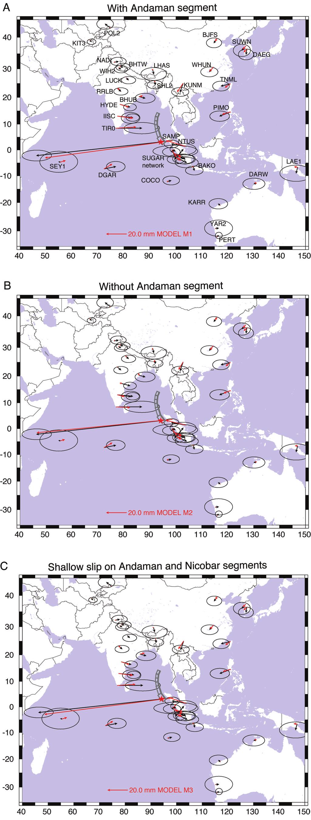
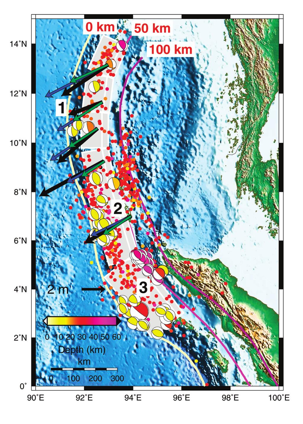
1 The Size and Duration of the Sumatra-Andaman Earthquake from Far-Field Static Offsets P. Banerjee, 1 F. F. Pollitz, 2 R. Bürgmann 3 * 1 Wadia Institute of Himalayan Geology, Dehra Dun, , India. 2 U.S. Geological Survey, Menlo Park, CA 94025, USA. 3 Department of Earth and Planetary Science and Berkeley Seismological Laboratory, University of California, Berkeley, CA 94720, USA. *To whom correspondence should be addressed. burgmann@seismo.berkeley.edu The 26 December 2004 Sumatra earthquake produced static offsets at continuously operating GPS stations at distances of up to 4500 km from the epicenter. We used these displacements to model the earthquake, and include consideration of the Earth s shape and depth-varying rigidity. The results imply that the average slip was >5 m along the full length of the rupture, including the ~650- km-long Andaman segment. Comparison of the source derived from the far-field static offsets with seismically derived estimates suggests that 25 to 35% of the total moment release occurred at periods greater than 1 hour. Taking into consideration the strong dip-dependence of moment estimates, the magnitude of the earthquake did not exceed M w = 9.2. The 26 December, 2004 Sumatra-Andaman earthquake was the largest seismic event to strike in the era of modern space geodesy. This event apparently ruptured a > 1200 km section of the megathrust in a complex sequence of rapid and slow slip episodes that lasted for greater than 1000 s (1, 2). The estimates of the size of the earthquake from seismic data are highly sensitive to the method and frequency band used in the analysis and range from the initial Harvard CMT estimate of M 0 = 4.0 x Nm (M w 9.0) to as much as 3 times that, as inferred from very long-period data (> 500 s) (3). Static surface offsets are caused by the elastic deformation of the Earth in response to the earthquake. Geodetic measurements of these motions can be used to derive kinematic rupture models and calculate the size of the event, independent of the seismic energy released by the earthquake. Here we utilize data from 41 continuously operating GPS stations to calculate coseismic surface displacements throughout southeast Asia (4). All but five of the stations are located at distances > 1000 km from the earthquake epicenter (Fig. 1). We combined our own solutions with daily solutions of global IGS stations (5). The GPS data were processed using the GAMIT/GLOBK software package to produce time series of station coordinates in the ITRF-2000 reference frame spanning at least 20 days before and after the earthquake (see Supporting Online Material, and fig. S1). We estimated offsets at the time of the earthquake by differencing the mean positions in the 5-days before and after the earthquake, respectively. Data from the first 5 hours following the earthquake are not included in that day s solution. We only used the horizontal components in our analysis. We also utilized estimated offsets from campaign GPS measurements on the Andaman and Nicobar Islands (6). The GPS data show that there was a coherent surface motion roughly directed toward the earthquake rupture at distances up to 4500 km from the epicenter (Fig. 1, table S1). The standard approach of modeling the surface motions from an earthquake using an elastic half-space approximation of the Earth (7) is inappropriate for an event of the magnitude and dimensions of the Sumatra earthquake. We model the event using PREM, a spherically-layered elastic structure of the earth determined from inversion of Earth s free oscillation spectra (8, 9). Static deformation in a spherical geometry is evaluated using the method of (10, 11). Forward model comparisons of the Sumatra earthquake show that surface motions calculated with a homogeneous spherical model greatly exceed surface motions of the layered spherical model at large distances (fig. S2). We define the geometry of the earthquake rupture based on constraints provided by the distribution of aftershocks and independent seismic source studies (1). We sub-divided the model geometry into three principal along-strike segments aligned with the strike of the megathrust from Sumatra to the northern Andaman Islands (table S2). The magnitudes of the far-field displacements are highly sensitive to fault dip (fig. S4), and we thus subdivided each segment in our model into two sub-segments to simulate the dip increase with depth. This geometry is consistent with seismic constraints of depths to the top of the slab (12) and the ~30 nodal-plane dips of a large cluster of aftershocks at ~5 N and depths of 45 to 50 km (Fig. 2). Seismic source studies suggest that the rake of the rupture became more oblique toward the north (2). Little strike-slip motion on the southern segment is evident in the / / 19 May 2005 / Page 1/ /science
2 focal mechanism solutions of the aftershocks but significant strike-slip motion appears likely on the Andaman and Nicobar segments (segments 1 and 2 in Fig. 2). The firstorder models that we consider therefore involve uniform dipslip and strike-slip components on the Andaman and Nicobar segments and uniform dip slip on the southern segment. If we solve for the optimal uniform slip values on each rupture segment (Model M1 in Table 1), the slip averages more than 5 m on all segments. The displacement field predicted by this model (Fig. 1A) fits the GPS dataset well at all distance ranges. A second case (Model M2), which does not allow for slip on the Andaman segment results in a significantly worse fit (13) (Table 1). The predicted displacement field of Model M2 (Fig. 1B) fails particularly to predict the coseismic offsets of Indian sites, which moved up to 25 mm eastward. This confirms that the Andaman segment participated in the Sumatra-Andaman earthquake sequence and slipped by several meters predominantly as dip slip, but with a minor, right-lateral strike-slip component. A variation of Model M1 in which the deeper subsegment of segment 3 is neglected leads to a significantly worse fit (reduced χ 2 =1.63 versus 1.36 for Model M1). The sensitivity to fault dip around the southern part of the rupture arises from the large dependence of displacement azimuth on dip at Sumatran sites south of the equator (fig. S4). This indicates that the deeper portion of the megathrust in the southernmost part of the rupture participated with several meters of slip, consistent with the occurrence of deeper aftershocks there (Fig. 2). If we restrict slip on the northern segments 1 and 2 to their shallowly dipping portions, the dataset is fit nearly as well as that involving slip on the wider faults and estimated slip values nearly double (Model M3 in Table 1 and Fig. 1C). These kinematic models may be compared with available horizontal movements determined from campaign GPS measurements of the Andaman and Nicobar Islands (6) (Fig. 2). Model M3 generally matches well the measured offsets, whereas model M1 predicts offsets that are too small and predicts the incorrect sense of uplift at some of these sites. These comparisons indicate that most of the coseismic slip was shallow (less than ~30 km depth) in these regions. However, the actual slip distribution is expected to be more complex than our simple uniform slip models, consistent with substantial heterogeneity in the observed near-field uplift and subsidence patterns along the Island chains (14). The scalar seismic moment of the earthquake sequence calculated with Model M1 is M 0 =5.67 x Nm, corresponding to a moment magnitude of M w =9.14. This is 40% larger than the seismic moment determined in the Harvard CMT solution using long period body waves and surface waves up to 300 sec period. It is about one-half of that determined by (3) using free oscillations up to one hour period, which corresponds to M w =9.30. We note that source excitation of very-long-period fundamental spheroidal modes (15) is primarily through the moment tensor components M rr and (M tt + M pp ), which are proportional to slip x sin(λ) x sin(2δ), where λ is fault rake and δ is dip. With moderate dips of δ =35 used here on the deeper portions of the various segments, the contribution to the free oscillation excitation is equivalent to that produced by a 15 -dipping fault with twice the slip. An increase in seismic moment will therefore result if slip is constrained to be on the shallowly-dipping portions of the fault segments. This is verified by Model M3, which is identical to Model M1 except that slip on segments 1 and 2 is restricted to their shallowly-dipping portions and has an increased M w =9.17. The best-fitting point source constrained to the CMT source depth of 28.4 km and dip of 8 (i.e., the source depth and dip assumed by (3)) results in M w =9.37 (Model P in Table 1) and a scalar moment M 0 that is 27% greater than that estimated by (3). The sensitivity of the scalar moment to fault dip is directly illustrated in Fig. 3A, where M 0 estimated from inversion for the best-fitting point source exhibits a ~ (sin 2δ) -1 dependence, whereas the estimated moment tensor component M rr varies little with changing dip. Thus, once the steeper average dip of the Sumatra rupture is taken into consideration the estimated moment magnitude does not exceed M w = 9.2. The static displacement field measures earthquake size at periods far greater than the ~1 hour period measured by Earth s free oscillations (3). A useful measure of the earthquake size is the combination of moment tensor components M rr and (M tt + M pp ) which dominate the excitation of both the low-degree fundamental spheroidal modes as well as the static displacements. Since M rr = -(M tt + M pp ) for a shear dislocation, we consider the single measure M rr, which carries the advantage of being nearly geometryindependent (Fig. 3A). The model of (3) corresponds to M rr = 2.59 x Nm. Our finite source models yield M rr = 3.26 to 3.61 x Nm (Table 1). Fig. 3B demonstrates a systematic increase in M rr with period, including the CMT solution involving periods < 300 s and the seismic slip inversion of (1) at periods up to 2000 s. This trend, first noted by (3), implies that about 25-35% of the total seismic moment release occurred beyond the ~1 hour timescale that is directly detectable with seismic waves. The precise time of cessation of significant moment release is uncertain. The GPS time series (fig. S1) qualitatively suggest an upper bound of 1 day. If most or all of the post-1 hour slip were confined to the Andaman segment, then the evolution of aftershocks may provide guidance. Moderate-sized earthquakes on the Andaman segment may have occurred on localized asperities simultaneously with predominantly aseismic slip. The rate of moderate earthquakes on the Andaman segment (Fig. 3B) suggests that a large part of the slip occurred between 40 / / 19 May 2005 / Page 2/ /science
3 minutes after the mainshock, coinciding approximately with the initiation of coseismic subsidence of Port Blair (14), and 2.5 hours after the mainshock. References and Notes 1. T. Lay et al., Science 308, 1127 (2005). 2. C. J. Ammon et al., Science 308, 1133 (2005). 3. S. Stein, E. Okal, Nature 434, (2005). 4. The GPS data are from stations belonging to the International GPS Service (IGS) global network, the BAKOSURTANAL Indonesian network, the Sumatran GPS Array operated by the Tectonic Observatory at Caltech and the Indonesian Institute of Science (LIPI), and the Indian "National Program on GPS" Network of the Department of Science & Technology made available by the Survey of India GPS Data Centre. 5. We use daily solutions of global GPS stations processed and archived at the Scripps Orbital and Permanent Array Center ( 18 IGS stations located > 5000 km from the rupture are used in the ITRF-2000 reference frame realization. Our regional solution includes 25 stations, 9 of which are in common with the SOPAC solution (table S1). 6. C. P. Rajendran, A. Earnest, K. Rajendran, R. Bilham, J. T. Freymueller, Nature submitted (2005). 7. Y. Okada, Bull. Seism. Soc. Am. 75, (1985). 8. A. M. Dziewonski, D. L. Anderson, Phys. Earth Planet. Inter. 25, (1981). 9. The PREM model contains large increases in rigidity at major discontinuities at depth 25 km (Mohorovocic discontinuity), 220 km (base of asthenosphere), 400 km, and 670 km (upper mantle-lower mantle boundary), followed by a decrease to zero rigidity at 2891 km (coremantle boundary). Our modeling includes the fluid outer core but not the solid inner core. 10. F. F. Pollitz, Geophys. J. Int. 125, 1-14 (1996). 11. A spherical harmonic expansion from l=1 to l=1500 is used to represent the spherical displacement fields. The l=1 component is found to be very important for correctly synthesizing far-field displacements. For typical Sumatra slip models, the predicted displacement at the farthest (Korean) sites amounts to several mm and arises almost entirely from the l=1 component of the displacement field. 12. O. Gudmundsson, M. Sambridge, J. Geophys. Res. 103, (1998). 13. A statistical F-test shows that the improvement in data fit with respect to Model M2 by including the additional two parameters of the Andaman segment is significant at 99.93% confidence (Model M1) or 99.76% confidence (Model M3). 14. R. G. Bilham, E. R. Engdahl, N. Feldl, S. P. Satyabala, Seismol. Res. Lett. in press (2005). 15. F. Gilbert, A. M. Dziewonski, Phil. Trans. Roy. Soc. London A278, (1975). 16. We thank C.P. Rajendran and Roger Bilham for providing results prior to publication. GPS data processing was carried out under a DST-sponsored project to PB. Supporting Online Material SOM Text Figs. S1 to S4 Tables S1 and S2 References and Notes 18 April 2005; accepted 10 May 2005 Published online 19 May 2005; /science Include this information when citing this paper. Fig. 1. GPS measured coseismic offsets (black arrows tipped with 95% confidence ellipses) and motions predicted from optimized slip on 3 rupture segments in an elastic and spherically-layered model representation of the Earth (red arrows). Predicted displacements are from (A) Model M1, (B) Model M2, and (C) Model M3. The surface projections of the model dislocations are shown as bold rectangles. A star indicates the epicenter of the earthquake. Fig. 2. Three-segment fault geometry of the Sumatra- Andaman Islands earthquake. Superimposed are the hypocenters of M>4 earthquakes occurring from 26 December, 2004 to 5 January, 2005 from the NEIC catalog, the subset of CMT aftershock focal mechanisms with reverse slip (plunge of tension axis > 45 ), and the 0, 50 km, and 100 km isocontours of the slab-top depth from (12). Fault geometry parameters are in table S2. Also shown are horizontal GPS offsets (solid black arrows) from the Andaman and Nicobar Islands from (6) compared with the predictions of Models M1 (green) and M3 (blue). Fig. 3. (A) Scalar seismic moment M 0 and moment tensor component M rr derived from inversion of GPS dataset for best-fitting point source subject to fixed position at 8.0 N, 93.3 E, strike 340, and CMT source depth of 28.4 km. Right-hand axis displays the corresponding reduced χ 2 excluding SAMP. (All static point source models yield a poor fit to SAMP). (B) Moment tensor component M rr derived from the CMT solution (periods < 300 s), the seismic slip inversion of (1) (periods < 2000 s), and free oscillations (3) compared with that of Models M1 and M3 derived from the far-field static offset. An average rake of 110 and average fault dip of 13.5 was assumed to convert scalar seismic moment of 6.0 x Nm estimated in (1) to the corresponding M rr. Black curve is the rate of M 5 earthquakes (from NEIC catalog) that occurred on the Andaman segment as a function of time after the mainshock, / / 19 May 2005 / Page 3/ /science
4 smoothed using a Gaussian scaling time of 0.25 hours. Shallow aftershocks in the back-arc region (8 N to 10 N and east of ~93.5 E; Fig. 2) are excluded. / / 19 May 2005 / Page 4/ /science
5
6
7
8 Table 1. Fit of Sumatra slip models to far-field GPS Model u 1 λ 1 u 2 λ 2 u 3 χ 2 M 0 M rr M w m ( ) m ( ) m Nm Nm M1 5.3± ±5 9.2± ±7 6.0± M ± ±7 5.8± M3 10.5± ±5 14.1± ±8 6.6± P u i and λ i denote, respectively, slip and rake on fault i. We hold fixed λ 3 = 90. Inversions are subjected to the constraint 90 = λ 3 λ 2 λ 1. Variable rake on fault-1 subsegments is described in Table S2. Reduced χ 2, equal to the full χ 2 divided by N n, where N = 82 is the number of data constraints and n is the number of independent parameters (n = 5 for Models M1 and M3, n = 3 for Model M2, n = 5 for Model P). Value fixed in inversion. Uniform slip on segments 1 and 2 is restricted to their respective shallow portions, i.e., only from 0 to 30 km depth. Best-fitting point source constrained to CMT depth of 28.4 km and dip of 8. Point source location and geometry: 8.0 N, 93.3 E, strike=340, rake=102. χ 2 = 1.52 excluding SAMP, χ 2 = 6.19 with SAMP.
Coseismic Slip Distributions of the 26 December 2004 Sumatra Andaman and 28 March 2005 Nias Earthquakes from GPS Static Offsets
 Bulletin of the Seismological Society of America, Vol. 97, No. 1A, pp. S86 S102, January 2007, doi: 10.1785/0120050609 E Coseismic Slip Distributions of the 26 December 2004 Sumatra Andaman and 28 March
RELOCATION OF THE MACHAZE AND LACERDA EARTHQUAKES IN MOZAMBIQUE AND THE RUPTURE PROCESS OF THE 2006 Mw7.0 MACHAZE EARTHQUAKE
 RELOCATION OF THE MACHAZE AND LACERDA EARTHQUAKES IN MOZAMBIQUE AND THE RUPTURE PROCESS OF THE 2006 Mw7.0 MACHAZE EARTHQUAKE Paulino C. FEITIO* Supervisors: Nobuo HURUKAWA** MEE07165 Toshiaki YOKOI** ABSTRACT
Seth Stein and Emile Okal, Department of Geological Sciences, Northwestern University, Evanston IL USA. Revised 2/5/05
 Sumatra earthquake moment from normal modes 2/6/05 1 Ultra-long period seismic moment of the great December 26, 2004 Sumatra earthquake and implications for the slip process Seth Stein and Emile Okal,
A search for seismic radiation from late slip for the December 26, 2004 Sumatra-Andaman (M w = 9.15) earthquake
 earthquake") Click Here for Full Article GEOPHYSICAL RESEARCH LETTERS, VOL. 33, L18305, doi:10.1029/2006gl027286, 2006 A search for seismic radiation from late slip for the December 26, 2004 Sumatra-Andaman (M w =
Click Here for Full Article GEOPHYSICAL RESEARCH LETTERS, VOL. 33, L18305, doi:10.1029/2006gl027286, 2006 A search for seismic radiation from late slip for the December 26, 2004 Sumatra-Andaman (M w =
Rapid Determination of Earthquake Magnitude using GPS for Tsunami Warning Systems: An Opportunity for IGS to Make a Difference
 Rapid Determination of Earthquake Magnitude using GPS for Tsunami Warning Systems: An Opportunity for IGS to Make a Difference Geoffrey Blewitt, 1 Corné Kreemer, 1 William C. Hammond, 1 Hans-Peter Plag,
Centroid moment-tensor analysis of the 2011 Tohoku earthquake. and its larger foreshocks and aftershocks
 Earth Planets Space, 99, 1 8, 2011 Centroid moment-tensor analysis of the 2011 Tohoku earthquake and its larger foreshocks and aftershocks Meredith Nettles, Göran Ekström, and Howard C. Koss Lamont-Doherty
Global deformation from the great 2004 Sumatra-Andaman Earthquake observed by GPS: Implications for rupture process and global reference frame
 Earth Planets Space, 58, 141 148, 2006 Global deformation from the great 2004 Sumatra-Andaman Earthquake observed by GPS: Implications for rupture process and global reference frame Corné Kreemer, Geoffrey
1.3 Short Review: Preliminary results and observations of the December 2004 Great Sumatra Earthquake Kenji Hirata
 1.3 Short Review: Preliminary results and observations of the December 2004 Great Sumatra Earthquake Kenji Hirata We give a brief review about observations and preliminary results regarding the 2004 great
Ground displacement in a fault zone in the presence of asperities
 BOLLETTINO DI GEOFISICA TEORICA ED APPLICATA VOL. 40, N. 2, pp. 95-110; JUNE 2000 Ground displacement in a fault zone in the presence of asperities S. SANTINI (1),A.PIOMBO (2) and M. DRAGONI (2) (1) Istituto
Seismic Characteristics and Energy Release of Aftershock Sequences of Two Giant Sumatran Earthquakes of 2004 and 2005
 P-168 Seismic Characteristics and Energy Release of Aftershock Sequences of Two Giant Sumatran Earthquakes of 004 and 005 R. K. Jaiswal*, Harish Naswa and Anoop Singh Oil and Natural Gas Corporation, Vadodara
Centroid-moment-tensor analysis of the 2011 off the Pacific coast of Tohoku Earthquake and its larger foreshocks and aftershocks
 LETTER Earth Planets Space, 63, 519 523, 2011 Centroid-moment-tensor analysis of the 2011 off the Pacific coast of Tohoku Earthquake and its larger foreshocks and aftershocks Meredith Nettles, Göran Ekström,
Inquiry: Sumatran earthquakes with GPS Earth Science Education
 Inquiry: Sumatran earthquakes with GPS Earth Science Education www.earthobservatory.sg Preparation: Before doing this investigation, complete two introductory investigations using GPS data from UNAVCO
News Release December 30, 2004 The Science behind the Aceh Earthquake
 News Release December 30, 2004 The Science behind the Aceh Earthquake PASADENA, Calif. - Kerry Sieh, the Robert P. Sharp Professor of Geology at the California Institute of Technology and a member of Caltech's
COULOMB STRESS CHANGES DUE TO RECENT ACEH EARTHQUAKES
 COULOMB STRESS CHANGES DUE TO RECENT ACEH EARTHQUAKES Madlazim Physics Department, Faculty Mathematics and Sciences of Surabaya State University (UNESA) Jl. Ketintang, Surabaya 60231, Indonesia. e-mail:
DETERMINATION OF SLIP DISTRIBUTION OF THE 28 MARCH 2005 NIAS EARTHQUAKE USING JOINT INVERSION OF TSUNAMI WAVEFORM AND GPS DATA
 Synopses of Master Papers Bulletin of IISEE, 47, 115-10, 013 DETERMINATION OF SLIP DISTRIBUTION OF THE 8 MARCH 005 NIAS EARTHQUAKE USING JOINT INVERSION OF TSUNAMI WAVEFORM AND GPS DATA Tatok Yatimantoro
Scaling of apparent stress from broadband radiated energy catalogue and seismic moment catalogue and its focal mechanism dependence
 Earth Planets Space, 53, 943 948, 2001 Scaling of apparent stress from broadband radiated energy catalogue and seismic moment catalogue and its focal mechanism dependence Z. L. Wu Institute of Geophysics,
Slip distributions of the 1944 Tonankai and 1946 Nankai earthquakes including the horizontal movement effect on tsunami generation
 Slip distributions of the 1944 Tonankai and 1946 Nankai earthquakes including the horizontal movement effect on tsunami generation Toshitaka Baba Research Program for Plate Dynamics, Institute for Frontier
Widespread Ground Motion Distribution Caused by Rupture Directivity during the 2015 Gorkha, Nepal Earthquake
 Widespread Ground Motion Distribution Caused by Rupture Directivity during the 2015 Gorkha, Nepal Earthquake Kazuki Koketsu 1, Hiroe Miyake 2, Srinagesh Davuluri 3 and Soma Nath Sapkota 4 1. Corresponding
Co-seismic Gravity Changes Computed for a Spherical Earth Model Applicable to GRACE Data
 Chapter 2 Co-seismic Gravity Changes Computed for a Spherical Earth Model Applicable to GRACE Data W.Sun,G.Fu,andSh.Okubo Abstract Dislocation theories were developed conventionally for a deformed earth
RELOCATION OF LARGE EARTHQUAKES ALONG THE PHILIPPINE FAULT ZONE AND THEIR FAULT PLANES
 RELOCATION OF LARGE EARTHQUAKES ALONG THE PHILIPPINE FAULT ZONE AND THEIR FAULT PLANES Rey M. Lumbang MEE12608 Supervisor: Nobuo Hurukawa ABSTRACT We relocated large magnitude (Mw 7.0) earthquakes that
Earthquake Doublet Sequences: Evidence of Static Triggering in the Strong Convergent Zones of Taiwan
 Terr. Atmos. Ocean. Sci., Vol. 19, No. 6, 589-594, December 2008 doi: 10.3319/TAO.2008.19.6.589(PT) Earthquake Doublet Sequences: Evidence of Static Triggering in the Strong Convergent Zones of Taiwan
Existence of finite rigidity layer at the base of the Earth s liquid outer core inferred from anomalous splitting of normal modes
 LETTER Earth Planets Space, 54, 67 7, 22 Existence of finite rigidity layer at the base of the Earth s liquid outer core inferred from anomalous splitting of normal modes Seiji Tsuboi,2 and Masanori Saito
GPS Strain & Earthquakes Unit 5: 2014 South Napa earthquake GPS strain analysis student exercise
 GPS Strain & Earthquakes Unit 5: 2014 South Napa earthquake GPS strain analysis student exercise Strain Analysis Introduction Name: The earthquake cycle can be viewed as a process of slow strain accumulation
SUPPLEMENTARY INFORMATION
 doi:10.1038/nature11492 Figure S1 Short-period Seismic Energy Release Pattern Imaged by F-net. (a) Locations of broadband seismograph stations in Japanese F-net used for the 0.5-2.0 Hz P wave back-projection
revised October 30, 2001 Carlos Mendoza
 Earthquake Sources in the circum-caribbean Region Puerto Rico Tsunami Mitigation and Warning Program Federal Emergency Management Agency Preliminary Report: Task 3 revised October 30, 2001 Carlos Mendoza
Rupture Process of the Great 2004 Sumatra-Andaman Earthquake
 Rupture Process of the Great 2004 Sumatra-Andaman Earthquake Supporting Online Materials Submitted to Science, March 12, 2005 Charles J. Ammon 1, Ji Chen 2, Hong-Kie Thio 3, David Robinson 5, Sidao Ni
Basics of the modelling of the ground deformations produced by an earthquake. EO Summer School 2014 Frascati August 13 Pierre Briole
 Basics of the modelling of the ground deformations produced by an earthquake EO Summer School 2014 Frascati August 13 Pierre Briole Content Earthquakes and faults Examples of SAR interferograms of earthquakes
to: Interseismic strain accumulation and the earthquake potential on the southern San
 Supplementary material to: Interseismic strain accumulation and the earthquake potential on the southern San Andreas fault system by Yuri Fialko Methods The San Bernardino-Coachella Valley segment of the
Sendai Earthquake NE Japan March 11, Some explanatory slides Bob Stern, Dave Scholl, others updated March
 Sendai Earthquake NE Japan March 11, 2011 Some explanatory slides Bob Stern, Dave Scholl, others updated March 14 2011 Earth has 11 large plates and many more smaller ones. Plates are 100-200 km thick
Seismological Aspects of the December 2004 Great Sumatra-Andaman Earthquake
 Seismological Aspects of the December 2004 Great Sumatra-Andaman Earthquake Hiroo Kanamori, a M.EERI The 2004 Great Sumatra-Andaman earthquake had an average source duration of about 500 sec. and a rupture
ON NEAR-FIELD GROUND MOTIONS OF NORMAL AND REVERSE FAULTS FROM VIEWPOINT OF DYNAMIC RUPTURE MODEL
 1 Best Practices in Physics-based Fault Rupture Models for Seismic Hazard Assessment of Nuclear ON NEAR-FIELD GROUND MOTIONS OF NORMAL AND REVERSE FAULTS FROM VIEWPOINT OF DYNAMIC RUPTURE MODEL Hideo AOCHI
Synthetic Seismicity Models of Multiple Interacting Faults
 Synthetic Seismicity Models of Multiple Interacting Faults Russell Robinson and Rafael Benites Institute of Geological & Nuclear Sciences, Box 30368, Lower Hutt, New Zealand (email: r.robinson@gns.cri.nz).
Rotation of the Principal Stress Directions Due to Earthquake Faulting and Its Seismological Implications
 Bulletin of the Seismological Society of America, Vol. 85, No. 5, pp. 1513-1517, October 1995 Rotation of the Principal Stress Directions Due to Earthquake Faulting and Its Seismological Implications by
Rapid determination of earthquake magnitude using GPS for tsunami warning systems
 Rapid determination of earthquake magnitude using GPS for tsunami warning systems Geoffrey Blewitt, 1 Corné Kreemer, 1 William C. Hammond, 1 Hans-Peter Plag, 1 Seth Stein, and Emile Okal The 6 December
Report on Banda Aceh mega-thrust earthquake, December 26, 2004
 Report on Banda Aceh mega-thrust earthquake, December 26, 2004 Prepared January 7 th 2005 by C. Vigny, on behalf of the SEAMERGES (*) participants On the morning of December 26 th in SE Asia, 30 km below
Triggering of earthquakes during the 2000 Papua New Guinea earthquake sequence
 JOURNAL OF GEOPHYSICAL RESEARCH, VOL. 112,, doi:10.1029/2006jb004480, 2007 Triggering of earthquakes during the 2000 Papua New Guinea earthquake sequence Sun-Cheon Park 1 and Jim Mori 1 Received 3 May
Earthquake source parameters for the January, 2010, Haiti mainshock and aftershock sequence
 Earthquake source parameters for the January, 2010, Haiti mainshock and aftershock sequence Meredith Nettles 1,2 and Vala Hjörleifsdóttir 1,3 1 Lamont-Doherty Earth Observatory of Columbia University 2
Kinematics of the Southern California Fault System Constrained by GPS Measurements
 Title Page Kinematics of the Southern California Fault System Constrained by GPS Measurements Brendan Meade and Bradford Hager Three basic questions Large historical earthquakes One basic question How
Rupture Characteristics of Major and Great (M w 7.0) Megathrust Earthquakes from : 1. Source Parameter Scaling Relationships
 Megathrust Earthquakes from : 1. Source Parameter Scaling Relationships") Journal of Geophysical Research Solid Earth Supporting Information for Rupture Characteristics of Major and Great (M w 7.0) Megathrust Earthquakes from 1990-2015: 1. Source Parameter Scaling Relationships
Journal of Geophysical Research Solid Earth Supporting Information for Rupture Characteristics of Major and Great (M w 7.0) Megathrust Earthquakes from 1990-2015: 1. Source Parameter Scaling Relationships
Estimation of S-wave scattering coefficient in the mantle from envelope characteristics before and after the ScS arrival
 GEOPHYSICAL RESEARCH LETTERS, VOL. 30, NO. 24, 2248, doi:10.1029/2003gl018413, 2003 Estimation of S-wave scattering coefficient in the mantle from envelope characteristics before and after the ScS arrival
Seismic Activity near the Sunda and Andaman Trenches in the Sumatra Subduction Zone
 IJMS 2017 vol. 4 (2): 49-54 International Journal of Multidisciplinary Studies (IJMS) Volume 4, Issue 2, 2017 DOI: http://doi.org/10.4038/ijms.v4i2.22 Seismic Activity near the Sunda and Andaman Trenches
Coseismic slip distribution of the 1946 Nankai earthquake and aseismic slips caused by the earthquake
 Earth Planets Space, 53, 235 241, 2001 Coseismic slip distribution of the 1946 Nankai earthquake and aseismic slips caused by the earthquake Yuichiro Tanioka 1 and Kenji Satake 2 1 Meteorological Research
A GLOBAL MODEL FOR AFTERSHOCK BEHAVIOUR
 A GLOBAL MODEL FOR AFTERSHOCK BEHAVIOUR Annemarie CHRISTOPHERSEN 1 And Euan G C SMITH 2 SUMMARY This paper considers the distribution of aftershocks in space, abundance, magnitude and time. Investigations
Empirical Green s Function Analysis of the Wells, Nevada, Earthquake Source
 Nevada Bureau of Mines and Geology Special Publication 36 Empirical Green s Function Analysis of the Wells, Nevada, Earthquake Source by Mendoza, C. 1 and Hartzell S. 2 1 Centro de Geociencias, Universidad
Earthquakes and Earthquake Hazards Earth - Chapter 11 Stan Hatfield Southwestern Illinois College
 Earthquakes and Earthquake Hazards Earth - Chapter 11 Stan Hatfield Southwestern Illinois College What Is an Earthquake? An earthquake is the vibration of Earth, produced by the rapid release of energy.
27th Seismic Research Review: Ground-Based Nuclear Explosion Monitoring Technologies
 GROUND TRUTH LOCATIONS USING SYNERGY BETWEEN REMOTE SENSING AND SEISMIC METHODS-APPLICATION TO CHINESE AND NORTH AFRICAN EARTHQUAKES C. K. Saikia 1, H. K. Thio 2, D. V. Helmberger 2, G. Ichinose 1, and
Analysis of Seismological and Tsunami Data from the 1993 Guam Earthquake
 PAGEOPH, Vol. 144, Nos. 3/4 (1995) 0033-4553/95/040823-1551.50 + 0.20/0 9 1995 Birkh/iuser Verlag, Basel Analysis of Seismological and Tsunami Data from the 1993 Guam Earthquake YUICHIRO TANIOKA, 1 KENJI
Supporting Online Material for
 www.sciencemag.org/cgi/content/full/326/5949/112/dc1 Supporting Online Material for Global Surface Wave Tomography Using Seismic Hum Kiwamu Nishida,* Jean-Paul Montagner, Hitoshi Kawakatsu *To whom correspondence
Coulomb stress changes due to Queensland earthquakes and the implications for seismic risk assessment
 Coulomb stress changes due to Queensland earthquakes and the implications for seismic risk assessment Abstract D. Weatherley University of Queensland Coulomb stress change analysis has been applied in
Lessons from the 2004 Sumatra earthquake and the Asian tsunami
 Lessons from the 2004 Sumatra earthquake and the Asian tsunami Kenji Satake National Institute of Advanced Industrial Science and Technology Outline 1. The largest earthquake in the last 40 years 2. Tsunami
Materials and Methods The deformation within the process zone of a propagating fault can be modeled using an elastic approximation.
 Materials and Methods The deformation within the process zone of a propagating fault can be modeled using an elastic approximation. In the process zone, stress amplitudes are poorly determined and much
Earth Tides Can Trigger Shallow Thrust Fault Earthquakes
 Earth Tides Can Trigger Shallow Thrust Fault Earthquakes Elizabeth S. Cochran, 1 * John E. Vidale, 1 Sachiko Tanaka 2 1 Department of Earth and Space Sciences and Institute of Geophysics and Planetary
SOURCE PROCESS OF THE 2003 PUERTO PLATA EARTHQUAKE USING TELESEISMIC DATA AND STRONG GROUND MOTION SIMULATION
 Synopses of Master Papers Bulletin of IISEE, 47, 19-24, 2013 SOURCE PROCESS OF THE 2003 PUERTO PLATA EARTHQUAKE USING TELESEISMIC DATA AND STRONG GROUND MOTION SIMULATION Fabricio Moquete Everth* Supervisor:
Postseismic deformation of the Andaman Islands following the 26 December, 2004 Great Sumatra-Andaman Earthquake
 GEOPHYSICAL RESEARCH LETTERS, VOL.???, XXXX, DOI:1.129/, Postseismic deformation of the Andaman Islands following the 26 December, 24 Great Sumatra-Andaman Earthquake J. Paul, 1 A. R. Lowry, 2 R. Bilham,
Seismic Source Mechanism
 Seismic Source Mechanism Yuji Yagi (University of Tsukuba) Earthquake Earthquake is a term used to describe both failure process along a fault zone, and the resulting ground shaking and radiated seismic
AVERAGE AND VARIATION OF FOCAL MECHANISM AROUND TOHOKU SUBDUCTION ZONE
 13 th World Conference on Earthquake Engineering Vancouver, B.C., Canada August 1-6, 24 Paper No. 414 AVERAGE AND VARIATION OF FOCAL MECHANISM AROUND TOHOKU SUBDUCTION ZONE Shunroku YAMAMOTO 1 Naohito
2 compared with the uncertainty in relative positioning of the initial triangulation (30 { 50 mm, equivalent to an angular uncertainty of 2 p.p.m. ove
 Reply to: `Comment on \Geodetic investigation of the 13 May 1995 Kozani { Grevena (Greece) earthquake" by Clarke et al.' by Meyer et al. P. J. Clarke, 1 D. Paradissis, 2 P. Briole, 3 P. C. England, 1 B.
Earthquakes and Seismotectonics Chapter 5
 Earthquakes and Seismotectonics Chapter 5 What Creates Earthquakes? The term Earthquake is ambiguous: Applies to general shaking of the ground and to the source of the shaking We will talk about both,
Tsunami Physics and Preparedness. March 6, 2005 ICTP Public Information Office 1
 Tsunami Physics and Preparedness March 6, 2005 ICTP Public Information Office 1 What we do Provide world-class research facilities for scientists from developing world Foster advanced scientific research,
GNH7/GG09/GEOL4002 EARTHQUAKE SEISMOLOGY AND EARTHQUAKE HAZARD
 Tectonics Lecture 10 Global Seismotectonics Rigid plate translation A Map of the World s Fracture Zones Magnetic anomalies and fracture zones form the basic building blocks for the construction of isochron
RELOCATION OF LARGE EARTHQUAKES ALONG THE SUMATRAN FAULT AND THEIR FAULT PLANES
 Synopses of Master Papers Bulletin of IISEE, 47, 25-30, 2013 RELOCATION OF LARGE EARTHQUAKES ALONG THE SUMATRAN FAULT AND THEIR FAULT PLANES Biana Rahayu Wulandari MEE11605 Supervisor: Nobuo HURUKAWA ABSTRACT
Report on Banda Aceh mega-thrust earthquake, December 26, 2004
 Report on Banda Aceh mega-thrust earthquake, December 26, 2004 Prepared January 7 th 2005 by C. Vigny, on behalf of the SEAMERGES (*) participants On the morning of December 26 th, 2004 in SE Asia, 30
Slab pull, slab weakening, and their relation to deep intra-slab seismicity
 GEOPHYSICAL RESEARCH LETTERS, VOL. 32, L14305, doi:10.1029/2005gl022922, 2005 Slab pull, slab weakening, and their relation to deep intra-slab seismicity Susan L. Bilek Earth and Environmental Science
FULL MOMENT TENSOR ANALYSIS USING FIRST MOTION DATA AT THE GEYSERS GEOTHERMAL FIELD
 PROCEEDINGS, Thirty-Eighth Workshop on Geothermal Reservoir Engineering Stanford University, Stanford, California, February 11-13, 2013 SGP-TR-198 FULL MOMENT TENSOR ANALYSIS USING FIRST MOTION DATA AT
The March 11, 2011, Tohoku-oki earthquake (Japan): surface displacement and source modelling
: surface displacement and source modelling") The March 11, 2011, Tohoku-oki earthquake (Japan): surface displacement and source modelling Salvatore Stramondo Bignami C., Borgstrom S., Chini M., Guglielmino F., Melini D., Puglisi G., Siniscalchi V.,
The March 11, 2011, Tohoku-oki earthquake (Japan): surface displacement and source modelling Salvatore Stramondo Bignami C., Borgstrom S., Chini M., Guglielmino F., Melini D., Puglisi G., Siniscalchi V.,
Tsunami waveform analyses of the 2006 underthrust and 2007 outer-rise Kurile earthquakes
 Author(s) 2008. This work is licensed under a Creative Commons License. Advances in Geosciences Tsunami waveform analyses of the 2006 underthrust and 2007 outer-rise Kurile earthquakes Y. Tanioka 1, Y.
Separating Tectonic, Magmatic, Hydrological, and Landslide Signals in GPS Measurements near Lake Tahoe, Nevada-California
 Separating Tectonic, Magmatic, Hydrological, and Landslide Signals in GPS Measurements near Lake Tahoe, Nevada-California Geoffrey Blewitt, Corné Kreemer, William C. Hammond, & Hans-Peter Plag NV Geodetic
LECTURE 6 EARTHQUAKES AS TSUNAMI SOURCES
 LECTURE 6 EARTHQUAKES AS TSUNAMI SOURCES Northwestern University, 2007 TSUNAMI GENERATION by EARTHQUAKE SOURCES CLASSICAL APPROA CH 1. Consider model of EarthquakeRupture 2. Compute Static Deformation
Supporting Online Material for
 www.sciencemag.org/cgi/content/full/1131692/dc1 Supporting Online Material for Localized Temporal Change of the Earth s Inner Core Boundary This PDF file includes: Materials and Methods Figs. S1 to S3
Buried Strike Slip Faults: The 1994 and 2004 Al Hoceima, Morocco Earthquakes.
 Buried Strike Slip Faults: The 1994 and 2004 Al Hoceima, Morocco Earthquakes. Juliet Biggs 1, Eric Bergman 2, Brian Emmerson 3, Gareth Funning 4, James Jackson 3, Barry Parsons 1,Tim Wright 1. 1 COMET,
Azimuth with RH rule. Quadrant. S 180 Quadrant Azimuth. Azimuth with RH rule N 45 W. Quadrant Azimuth
 30 45 30 45 Strike and dip notation (a) N30 E, 45 SE ("Quadrant"): the bearing of the strike direction is 30 degrees east of north and the dip is 45 degrees in a southeast (SE) direction. For a given strike,
Bulletin of the Seismological Society of America, Vol. 97, No. 1A, pp. S43 S61, January 2007, doi: /
 Bulletin of the Seismological Society of America, Vol. 97, No. 1A, pp. S43 S61, January 2007, doi: 10.1785/0120050614 Teleseismic Relocation and Assessment of Seismicity (1918 2005) in the Region of the
Introduction to the Special Issue on the 2004 Sumatra Andaman Earthquake and the Indian Ocean Tsunami
 Name /mea_ssa971a_605412/971_05633/mp_1 12/05/2006 11:35AM Plate # 0 pg 1 # 1 Bulletin of the Seismological Society of America, Vol. 97, No. 1A, pp. S1 S5, January 2007, doi: 10.1785/0120050633 Introduction
DEFORMATION KINEMATICS OF TIBETAN PLATEAU DETERMINED FROM GPS OBSERVATIONS
 DEFORMATION KINEMATICS OF TIBETAN PLATEAU DETERMINED FROM GPS OBSERVATIONS Jinwei Ren Institute of Geology, China Seismological Bureau, Beijing 100029 China Tel: (10)62009095; Fax: (10)62009003; email:
Preliminary slip model of M9 Tohoku earthquake from strongmotion stations in Japan - an extreme application of ISOLA code.
 Preliminary slip model of M9 Tohoku earthquake from strongmotion stations in Japan - an extreme application of ISOLA code. J. Zahradnik 1), F. Gallovic 1), E. Sokos 2) G-A. Tselentis 2) 1) Charles University
Constraints on 2004 Sumatra Andaman earthquake rupture from GPS measurements in Andaman Nicobar Islands
 Earth and Planetary Science Letters 242 (2006) 365 374 www.elsevier.com/locate/epsl Constraints on 2004 Sumatra Andaman earthquake rupture from GPS measurements in Andaman Nicobar Islands V.K. Gahalaut
Source of the July 2006 West Java tsunami estimated from tide gauge records
 GEOPHYSICAL RESEARCH LETTERS, VOL. 33, L24317, doi:10.1029/2006gl028049, 2006 Source of the July 2006 West Java tsunami estimated from tide gauge records Yushiro Fujii 1 and Kenji Satake 2 Received 13
Earthquake Focal Mechanisms and Waveform Modeling
 Earthquake Focal Mechanisms and Waveform Modeling Rengin Gök Lawrence Livermore National Laboratory USA RELEMR Workshop İstanbul 2008 Gudmundar E. Sigvaldason The Dynamic Earth, USGS The size of the event
Summary so far. Geological structures Earthquakes and their mechanisms Continuous versus block-like behavior Link with dynamics?
 Summary so far Geodetic measurements velocities velocity gradient tensor (spatial derivatives of velocity) Velocity gradient tensor = strain rate (sym.) + rotation rate (antisym.) Strain rate tensor can
Earthquake patterns in the Flinders Ranges - Temporary network , preliminary results
 Earthquake patterns in the Flinders Ranges - Temporary network 2003-2006, preliminary results Objectives David Love 1, Phil Cummins 2, Natalie Balfour 3 1 Primary Industries and Resources South Australia
(Somerville, et al., 1999) 2 (, 2001) Das and Kostrov (1986) (2002) Das and Kostrov (1986) (Fukushima and Tanaka, 1990) (, 1999) (2002) ( ) (1995
 2 (, 2001) Das and Kostrov (1986) (2002) Das and Kostrov (1986) (Fukushima and Tanaka, 1990) (, 1999) (2002) ( ) (1995") ( ) 1995 ( ) (Somerville, et al., 1999) 2 (, 2001) (2001) Das and Kostrov (1986) (2002) Das and Kostrov (1986) GPS ) (Fukushima and Tanaka, 1990) (, 1999) (2002) ( ) (1995 1 (outer fault parameter) (inner
( ) 1995 ( ) (Somerville, et al., 1999) 2 (, 2001) (2001) Das and Kostrov (1986) (2002) Das and Kostrov (1986) GPS ) (Fukushima and Tanaka, 1990) (, 1999) (2002) ( ) (1995 1 (outer fault parameter) (inner
JCR (2 ), JGR- (1 ) (4 ) 11, EPSL GRL BSSA
, JGR- (1 ) (4 ) 11, EPSL GRL BSSA") Dun Wang ( ) In collaboration with: Hitoshi Kawakatsu, Jim Mori, Kazuki Koketsu, Takuto Maeda, Hiroshi Tsuroka, Jiancang Zhunag, Lihua Fang, and Qiang Yao School of Geosciences, China University of Geosciences
Dun Wang ( ) In collaboration with: Hitoshi Kawakatsu, Jim Mori, Kazuki Koketsu, Takuto Maeda, Hiroshi Tsuroka, Jiancang Zhunag, Lihua Fang, and Qiang Yao School of Geosciences, China University of Geosciences
Magnitude 7.6 & 7.4 SOLOMON ISLANDS
 A magnitude 7.6 earthquake struck near the Solomon Islands on Sunday morning local time; there were no immediate reports of damage. The earthquake was centered 100 km (60 miles) south of Kira Kira, a town
The Mw 6.2 Leonidio, southern Greece earthquake of January 6, 2008: Preliminary identification of the fault plane.
 The Mw 6.2 Leonidio, southern Greece earthquake of January 6, 28: Preliminary identification of the fault plane. J. Zahradnik 1, E. Sokos 2, A.Serpetsidaki 2, and G A.Tselentis 2 1 Charles University in
Source Characteristics of Large Outer Rise Earthquakes in the Pacific Plate
 Source Characteristics of Large Outer Rise Earthquakes in the Pacific Plate T. Sasatani, N. Takai, M. Shigefuji, and Y. Miyahara Hokkaido University, Sapporo, Japan W. Kawabata Electric Power Development
Introduction to Displacement Modeling
 Introduction to Displacement Modeling Introduction Deformation on the Earth surface informs us about processes and material properties below surface Observation tools: GPS (static-dynamic) InSAR (static)
Earthquakes Chapter 19
 Earthquakes Chapter 19 Does not contain complete lecture notes. What is an earthquake An earthquake is the vibration of Earth produced by the rapid release of energy Energy released radiates in all directions
GEORED Project: GNSS Geodesy Network for Geodynamics Research in Colombia, South America. Héctor Mora-Páez
 GEORED Project: GNSS Geodesy Network for Geodynamics Research in Colombia, South America. Héctor Mora-Páez Colombian Geological Survey UNAVCO SCIENCE MEETING Feb 27 March 1, 2012 Boulder, CO, TECTONIC
EARTHQUAKE SOURCE PARAMETERS FOR SUBDUCTION ZONE EVENTS CAUSING TSUNAMIS IN AND AROUND THE PHILIPPINES
 EARTHQUAKE SOURCE PARAMETERS FOR SUBDUCTION ZONE EVENTS CAUSING TSUNAMIS IN AND AROUND THE PHILIPPINES Joan Cruz SALCEDO Supervisor: Tatsuhiko HARA MEE09186 ABSTRACT We have made a set of earthquake source
2008 Monitoring Research Review: Ground-Based Nuclear Explosion Monitoring Technologies
 STRUCTURE OF THE KOREAN PENINSULA FROM WAVEFORM TRAVEL-TIME ANALYSIS Roland Gritto 1, Jacob E. Siegel 1, and Winston W. Chan 2 Array Information Technology 1 and Harris Corporation 2 Sponsored by Air Force
Triggering of Aftershocks of the Japan 2011 Earthquake by Earth Tides
 Triggering of Aftershocks of the Japan 2011 Earthquake by Earth Tides A. Datta and Kamal* Department of Earth Sciences, Indian Institute of Technology Roorkee, Roorkee-247667, Uttarakhand, India email:
Proposed modification on velocity attenuation relationships in West of Iran with special respect to Dorood fault
 Journal of Civil Engineering Research 01, (3): 6-11 DOI: 10.593/j.jce.01003.01 Proposed modification on velocity attenuation relationships in West of Iran with special respect to Dorood fault Katayoun
Journal of Geophysical Research - Solid Earth
 Journal of Geophysical Research - Solid Earth Supporting Information for Transpressional Rupture Cascade of the 2016 M w 7.8 Kaikoura Earthquake, New Zealand Wenbin Xu 1*, Guangcai Feng 2*, Lingsen Meng
RELATION BETWEEN RAYLEIGH WAVES AND UPLIFT OF THE SEABED DUE TO SEISMIC FAULTING
 13 th World Conference on Earthquake Engineering Vancouver, B.C., Canada August 1-6, 24 Paper No. 1359 RELATION BETWEEN RAYLEIGH WAVES AND UPLIFT OF THE SEABED DUE TO SEISMIC FAULTING Shusaku INOUE 1,
Automatic Moment Tensor Analyses, In-Situ Stress Estimation and Temporal Stress Changes at The Geysers EGS Demonstration Project
 PROCEEDINGS, 42nd Workshop on Geothermal Reservoir Engineering Stanford University, Stanford, California, February 13-15, 2017 SGP-TR-212 Automatic Moment Tensor Analyses, In-Situ Stress Estimation and
Coseismic Slip and Afterslip of the Great M w 9.15 Sumatra Andaman Earthquake of 2004
 Bulletin of the Seismological Society of America, Vol. 97, No. 1A, pp. S15 S173, January 007, doi: 10.1785/010050631 Coseismic Slip and Afterslip of the Great M w 9.15 Sumatra Andaman Earthquake of 004
SLIP DISTRIBUTION FOR THE 2004 SUMATRA-ANDAMAN EARTHQUAKE CONSTRAINED BY BOTH GPS DATA AND TSUNAMI RUN-UP MEASUREMENTS
 McKenzie D. and J. Jackson; 2002: Conditions for flow in the continental crust, Tectonics, 21, doi:10.1029/2002tc001394. McKenzie D. P.; 1977: The initiation of trenches: a finite amplitude instability,
Spatial and Temporal Distribution of Slip for the 1999 Chi-Chi, Taiwan, Earthquake
 Bulletin of the Seismological Society of America, 91, 5, pp. 1069 1087, October 2001 Spatial and Temporal Distribution of Slip for the 1999 Chi-Chi, Taiwan, Earthquake by Kuo-Fong Ma, Jim Mori, Shiann-Jong
Aftershocks are well aligned with the background stress field, contradicting the hypothesis of highly heterogeneous crustal stress
 JOURNAL OF GEOPHYSICAL RESEARCH, VOL. 115,, doi:10.1029/2010jb007586, 2010 Aftershocks are well aligned with the background stress field, contradicting the hypothesis of highly heterogeneous crustal stress
DATA REPOSITORY SUPPLEMENTARY MATERIAL. We analyzed focal mechanism solutions for aftershocks of the Loma Prieta
 GSA Data Repository item 2007141 DATA REPOSITORY SUPPLEMENTARY MATERIAL DR.1 Selection of aftershock sets and subsets We analyzed focal mechanism solutions for aftershocks of the Loma Prieta earthquake