506 Howard St. PO Box 22 Effingham, KS Phone: (913) Fax: (913)
|
|
|
- Jonathan McKinney
- 6 years ago
- Views:
Transcription
 833-4025 Fax: (913) 833-2960 February 7, 2013 Dear Citizens, According to the enclosed information packet from the National Weather Service, 43")

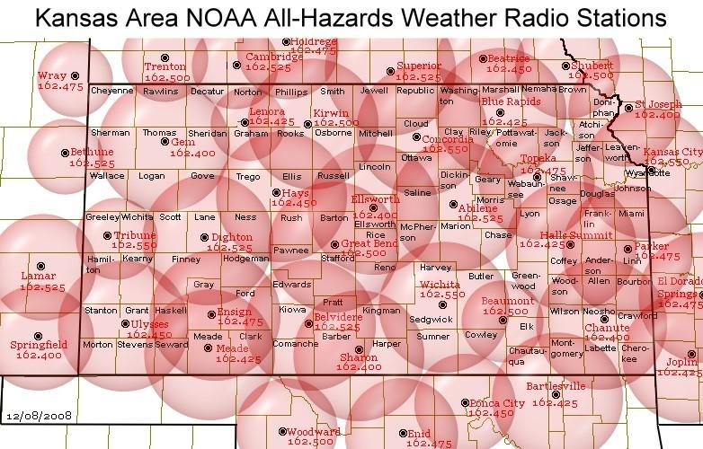
1 506 Howard St. PO Box 22 Effingham, KS Phone: (913) Fax: (913) February 7, 2013 Dear Citizens, According to the enclosed information packet from the National Weather Service, 43 tornadoes occurred on April 14 of 2012, resulting in 38 injuries. At Atchison County Emergency Management, we d like to raise awareness of severe weather and reduce the occurrence of injuries and death due to it. As severe weather season approaches, I urge you to review the enclosed information as well as participate in the tornado safety drill on Tuesday, March 5 at 1:30 pm. The drill is part of Severe Weather Awareness Week which is March 3-9, 2013 and is an opportunity to practice your facility s severe weather plan. As part of our county s hazardous weather plan, the sirens are tested the first Wednesday of each month (March-November) at 10 am. In addition, I d like to encourage you to attend a local SkyWARN StormSpotter meeting, presented by the National Weather Service. Below is a list of meetings in surrounding counties: Monday, Feb 25 at 7 pm, Leavenworth County, Warren Middle School, Leavenworth, KS Thursday, Feb 28 at 7 pm, Brown County, Horton High School Auditorium, Horton, KS Wednesday, March 13 at 7 pm, Jackson County, Jackson Co Senior Center, 312 Penn, Holton, KS Thursday, March 14 at 7 pm, Doniphan County, Troy Community Building, Troy, KS Wednesday, March 20 at 7pm, Jefferson County, Oskaloosa Middle School, Oskaloosa, KS A vital part of the warning and alert system is a NOAA weather radio in homes and businesses. Atchison County Emergency Management has Midland weather radios available for $30 at our office at 506 Howard, Effingham. Please contact us for information in regard to purchasing and programming the radios for local weather alerts. For more information on severe weather or the Atchison County Hazardous Weather Plan, please contact me at or wlanter@atcoks.org Sincerely, Wesley D Lanter Atchison County Emergency Manager


2 2013 KANSAS SEVERE WEATHER AWARENESS WEEK TORNADO SAFETY DRILL TUESDAY, MARCH 5th 1:30 PM CST INFORMATION PACKET National Weather Service
3 Table of Contents Page Number 2012 Kansas Tornado Facts Kansas Tornado Statistics by County 2012 Severe Summary for Extreme East Central and Northeast Kansas NWS Pleasant Hill, MO 2012 Severe Summary for Northeast and East Central Kansas NWS Topeka, KS 2012 Severe Summary for Central, South Central and SE Kansas NWS Wichita, KS 2012 Severe Summary for North Central Kansas NWS Hastings, NE 2012 Severe Summary for Southwest Kansas NWS Dodge City, KS 2012 Severe Summary for Northwest Kansas NWS Goodland, KS 2012 Severe Summary for Southeastern Kansas NWS Springfield, MO Severe Weather Handouts Pamphlets Weather Safety Handout in Spanish StormReady

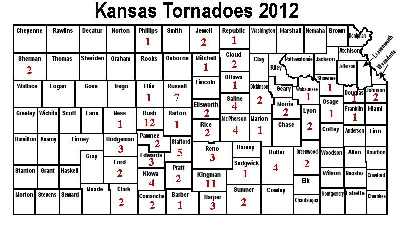
4 2012 Kansas Tornado Facts Tornadoes: 94 (33 above the average of 61) (14 above the past 30 year average of 80) (18 below the past 10 year average of 112) Fatalities: 1 Injuries: 50 Longest Track: Strongest: Most in a county: 50.3 miles (Rice-Ellsworth-McPherson-Saline counties, April 14, EF4) EF4 (Rice-Ellsworth-McPherson-Saline counties) 12 (Rush County - April 14th) Tornado Days: 13 (Days with 1 or more tornadoes) Most in one day: 43 (April 14) Most in one month: 52 (April) Tornado near Kanopolis Lake, KS on April 14, Photo courtesy of Scott Blair. First tornado of the year: Last tornado of the year: February 28 (Jewell County, 5:28 pm CST, EF0, 2.4 mile length, 50 yard width) September 17 (Shawnee County, 3:20 am CDT, EF0, 0.1 mile length, 10 yard width) Monthly Tornado Totals Month Jan Feb Mar Apr May Jun Jul Aug Sep Oct Nov Dec Total EF % EF % EF % EF % EF % EF % Total % Percent % 2012 Highlights: The tornado season began February 28th. Unfortunately, one of the eight tornadoes occurring that day struck the town of Harveyville resulting in damage, injuries and one fatality. April 2012 was a record month in terms of tornado count. The 52 tornadoes logged surpassed the old April record of 46 set in Forty three tornadoes occurred on April 14th resulting in 38 injuries. As the table indicates, the tornado season shut down dramatically after May when a large and persistent high pressure area dominated the remainder of the year. Only three weak tornadoes were logged after June 1st. Some noteworthy tornadoes include: February 28th Wabaunsee County - one fatality, 12 injuries. April 14th Sedgwick County - ~$500 million dollars in damage, 38 injuries. April 14th Rice County - ultimately traveled 50 miles into Ellsworth, McPherson and Saline counties. It was the only tornado in the state in 2012 classified as violent, rated an EF4. April 14th Stafford County - tornado reached a width of 1.5 miles 3
5 KANSAS TORNADO STATISTICS by County TORNADOES, FATALITIES, AND INJURIES County Tor Fat Inj County Tor Fat Inj County Tor Fat Inj Allen Anderson Atchison Barber Barton Bourbon Brown Butler Chase Chautauqua Cherokee Cheyenne Clark Clay Cloud Coffey Comanche Cowley Crawford Decatur Dickinson Doniphan Douglas Edwards Elk Ellis Ellsworth Finney Ford Franklin Geary Gove Graham Grant Gray Greeley Greenwood Hamilton Harper Harvey Haskell Hodgeman Jackson Jefferson Jewell Johnson Kearny Kingman Kiowa Labette Lane Leavenworth Lincoln Linn Logan Lyon McPherson Marion Marshall Meade Miami Mitchell Montgomery Morris Morton Nemaha Neosho Ness Norton Osage Osborne Ottawa Pawnee Phillips Pottawatomie Pratt Rawlins Reno Republic Rice Riley Rooks Rush Russell Saline Scott Sedgwick Seward Shawnee Sheridan Sherman Smith Stafford Stanton Stevens Sumner Thomas Trego Wabaunsee Wallace Washington Wichita Wilson Woodson Wyandotte Total
6 5
7 Check out a Storm Spotter and Weather Safety Training presentation near you this spring Each spring, the National Weather Service offices that serve the state of Kansas conduct storm spotter and weather safety training sessions in most counties in the state. The sessions are free and open to the public. You are not required to become a storm spotter, nor will you have to take a test; however the presentations provide a great deal of information on severe weather in Kansas. They cover severe weather safety, ways to get weather information from the National Weather Service, and you can meet a meteorologist from your local National Weather Service office. The schedule for storm spotter training sessions varies in each community, please check out and click on your location for more information on a training session in your area. Did you know that there are seven National Weather Service offices that serve portions of Kansas? The NWS offices are located in Goodland; Dodge City; Wichita; Topeka; Hastings, Nebraska; Pleasant Hill, Missouri; and Springfield, Missouri. Each office is staffed by a team of highly trained meteorologists, technicians, electronics technicians, information technology specialists, hydrologists, and administrative assistants. The NWS offices are staffed 24 hours a day, seven days a week, 365 days a year. Contact the NWS office in your area to learn more about weather, weather safety, NOAA Weather Radio, for office tours, or to learn more about careers in meteorology in the NWS or in NOAA. We are here to serve you! Kansas Tornado Facts Days with more than 20 tornadoes Date #Tornadoes 05/23/ /14/ /15/ /05/ /04/ /29/ /26/ /25/ /09/ /15/ /07/ /26/ /15/09 21 Kansas Tornado Count By Decade 1950s: s: s: s: s: s: s: 250 (through 2012) Most Tornadoes in One Episode May 23, Tornadoes April 14, Tornadoes June 15-16, Tornadoes 6

8 2012 Severe Weather Summary Extreme East Central and Northeast Kansas National Weather Service Pleasant Hill, MO 2012 began like 2011 ended, mild. This warm streak continued throughout much of the year. The only taste of winter eastern Kansas received early in 2012 was a 1 to 3 inch snowfall event in mid-february which produced very little in the way of impacts. The quiet weather continued into the early severe weather season as just a few minor events occurred in eastern Kansas, one on February 28 th and another a month later on March 28. The first event produced fairly wide-spread 60 mph winds across Leavenworth, Johnson, and Wyandotte counties. The second produced just a few dime to quarter sized hail reports in Leavenworth and Miami Counties. Severe weather didn t make a return appearance in far eastern Kansas until May 6 th when a few supercell thunderstorms produced widespread quarter to golfball sized hail mainly across Johnson County. More importantly, one of these storms produced two brief EF0 tornadoes in Johnson County, neither of which produced any damage. There were a few other even more minor severe thunderstorm events to finish out May. As we rolled into summer, the rains dried up and the heat set in. Numerous excessive heat warnings and advisories were issued during the summer months. This led to the biggest weather story of the year out east, the socalled flash drought of The term flash drought was coined by climatologists due to the intense and rapid onset of drought conditions across the region. Refer to table 1 to see that all but three months of 2012 had above normal temperatures and all but two experienced below normal precipitation. The hot temperatures and persistent and drastic lack of precipitation caused the region to advance from a D1 (moderate) to a D4 (exceptional) drought in a matter of 6 weeks. (see graphic to the right) Agriculture was especially hard hit by the drought as crops failed and streams and stock ponds dried up. By the end of 2012, numerous communities around the region were working to cut back on water usage. August and September brought a return to near normal precipitation which helped ease the drought slightly, but not completely eliminate it as eastern Kansas closed out the year with a significant precipitation deficit. The storms which brought the rains also brought isolated severe weather, but nothing widespread or extremely damaging. Month Temp. Precip. Departure Departure January February March April May June July August September October November December Table 1 Monthly departure from average at Johnson County Executive Airport 7


9 2012 Severe Weather Summary Northeast and North Central Kansas National Weather Service-Topeka, KS The 2012 severe weather season remained relatively quiet across northeast Kansas; however, there were a few remarkable events that occurred early in the season. The highlight of the severe weather season for northeast Kansas occurred the night of February 28th when a strong tornado impacted the town of Harveyville, Kansas. Due to the relatively arid conditions across northeast Kansas a severe drought took hold of the area and has persisted through the end of 2012 into By the end of the year a total of 12 tornadoes occurred across northeast Kansas including nine EF-0, two EF-1, and one EF-2. February 28 - On the evening of Tuesday, February 28, 2012, a very strong upper level storm system caused widespread thunderstorms to form across most of central and eastern Kansas. The storms initiated approximately 4:00 PM and increased in coverage and intensity throughout the night. Since atmospheric instability was not extremely high there were few reports of severe hail; however, many structures across the area were damaged due to strong, straight-line thunderstorm winds. The most significant event from the evening of February 28 was a strong tornado that impacted Harveyville, Kansas at approximately 9:03 pm CST. The town sustained significant damage to some structures including an apartment complex and a church. On Wednesday, February 29 a National Weather Service survey crew traveled to Harveyville to assess the damage and rated the tornado an EF-2 indicating wind speeds of mph. The tornado caused at least 12 injuries and one fatality. Three other tornadoes occurred across the area that night, but no injuries and only marginal damage to outbuildings and structures occurred from these other tornadoes. A strong tornado impacted Harveyville, Kansas on the night of February 28, causing significant damage to the town. Photos from NWS storm survey 8


10 March 28 - On the evening of March 28, 2012, northeast Kansas was impacted by large hail, one tornado and heavy rain. One storm impacted Osage County with hail larger than baseballs. A funnel cloud was also reported with this storm near Carbondale. Another storm impacted eastern Morris and Lyon counties bringing hen egg sized hail to Council Grove and golfball sized hail to Dunlap. The storm continued to move slowly and intensify across Lyon County and produced a brief tornado touchdown in rural Lyon County. Additional large hail reports of 2 inches were reported near Bushong. Heavy rain also fell from this storm due to its slow movement eastward and several Lyon County roads had to be barricaded due to water running over the road. Other storms moved across the area with hail up to the size of golf balls in Nemaha and Pottawatomie counties during the late evening hours. A tornado crosses the Saline/Ottawa County line on April 14th. Photo courtesy of Scott Blair April 14 - A volatile environment developed across Kansas that featured extremely strong wind shear and sufficient buoyancy (called convective energy) to allow supercell thunderstorms to develop ahead of a dry line across central Kansas. The supercells produced strong to violent tornadoes across central Kansas and tracked into parts of the NWS Topeka county warning area during the evening. A handful of tornadoes were reported along with some large hail reports with the most numerous reports of large hail occurring after midnight. April 27 - Supercell thunderstorms developed along a warm frontal boundary that was draped from near Concordia, Kansas to near Emporia, Kansas. Storms that developed moved northeast. As they encountered the warm front, they were able to exhibit low level rotation, and 2 brief weak tornadoes were confirmed during the evening. Otherwise, sporadic thunderstorm wind damage and large hail reports were more common. Also be sure to check if your county Emergency Manager has a facebook page for your county. Be sure to find your local NWS office on facebook US National Weather Service Dodge City, Kansas US National Weather Service Goodland, Kansas US National Weather Service Hastings, Nebraska US National Weather Service Kansas City, Missouri US National Weather Service Springfield, Missouri US National Weather Service Topeka, Kansas US National Weather Service Wichita, Kansas 9

11 2012 Severe Weather Summary Portions of Central, South Central and Southeast Kansas National Weather Service - Wichita, KS Below are summaries of notable 2012 weather events across central, south-central and southeast. While we realize that not all weather events affect everyone the same, we feel that the below list encapsulates some of the most memorable 2012 weather events across the area. The events are not listed in any particular order of magnitude or importance. Record Warmth of 2012 Primarily due to a very warm first 7 to 8 months of the year with all sites recording their warmest spring on record, 2012 went down into the record books as the warmest year on record for both Wichita and Chanute. This was the 6th warmest year for Salina. By early August, it was looking like summer 2012 was going to give summer 2011 a run for its money, although that ended with the arrival of somewhat cooler temperatures around August 10th. Much of the Sunflower State recorded a record or near-record warm In fact, the nation as a whole experienced a record warm year even exceeding all of the notoriously hot years of the 1930s and 1950s. See Table below summarizing 2012 temperature data for Wichita, Salina and Chanute along with the rankings and normals. 10


12 Rare February Tornadoes Impact South Central and Southeastern Kansas on February 28th, 2012 Photo Courtesy of Brandon Ivey A vigorous upper level system brought unusually rich gulf moisture northward into Kansas during the day on Tuesday, February 28th. A line of thunderstorms developed along a dryline over central and south central Kansas around 5pm once it encountered the deeper moisture. Severe weather began to break out over the region shortly thereafter with a tornado briefly observed in Reno County. The line of storms continued to race eastward producing damaging wind speeds of 60 to 110 mph and large hail ranging from walnut to baseball size. There were even a few storm related injuries reported in Labette County as the line of severe storms pushed through that area after 10pm. Tornado tracks on April 14th, 2013 across Central and South Central Kansas April 14th, 2012 Tornado Outbreak April 14th, 2012 will go down as one of the more prolific days in severe weather history for central and southeast Kansas. In all, a total of 24 tornadoes touched down across the 26 counties served by the NWS Wichita, KS office. Of those 24 tornadoes, one was rated as an EF4 (winds up to 199 mph) and two were rated as EF3 s (winds up to 167 mph). One surprising and fortunate statistic from this major event was the lack of injuries and fatalities considering that significant structural damage was noted to several homes and businesses. Each of the tornadoes classified as violent or strong were reported up to one mile in width at several points along their particular paths. Two other facts make this event memorable. First the NWS Wichita utilized enhanced hazard impact wording contained within the new Impact Based Warnings. Secondly, the Weather Channel broadcasted live from the NWS Wichita facility for approximately 9 hours. This was the first time that the Weather Channel 11


13 had access and broadcasted all facets of the event from the floor of the National Weather Service. This gave the public a unique perspective of how a NWS office operates during a severe weather event. Tornado tracks on May 19th, 2013 in Kingman and Harper Counties. EF3 damage to farmstead 4 miles west and 2 miles north of Harper, KS May 19th Kingman & Harper County Tornadoes May 19 th was not a typical tornado day in KS. The first few tornadoes that developed were along a weak front situated in northern Kingman and southern Reno counties. The rotation within these tornadoes was so weak that the radar barely hinted at the possibility of a tornado. However, due to the efforts of Kingman County law enforcement and storm chasers, our office was able to effectively issue tornado warnings and notify the people in harms way. However, as the event continued to unfold, the weak circulations began to encounter a more favorable environment and quickly intensified in southern Kingman and Harper counties. The tornado that took place northwest of the town of Harper was rated as an EF3. This EF3 damage occurred when the tornado struck a farmstead 4 miles west and 2 miles north of the town of Harper, KS. Another EF3 tornado occurred along the Kingman/ Harper county line as a strong tornado ripped through a wind farm causing damage to several turbines. One very interesting tidbit of information was also gathered from this tornado. A crane was left erect near the beginning of the wind field and recorded wind speed of 166 mph from approximately 200 feet off of the ground. EF1 damage to a wind turbine about 5 miles SE of Spivey, KS EF 4 Damage in Ellsworth County 12
 tallying 7.29 inches of moisture.")
14 Drought 2012 The year started out promising for much of the region with a precipitation surplus through early to midspring for many locations across the region. In fact, Wichita recorded its 3rd wettest winter on record (winter ) tallying 7.29 inches of moisture. Ironically, most of that fell in the liquid form as relatively warm temperatures held the season snowfall totals to a measly 3 inches. The faucet turned off by mid to late spring though, as high pressure in the mid and upper levels of the atmosphere began to dominate much of mid-america. This high pressure ridge, much like 2011, dominated through July resulting in persistent below normal rainfall. Salina recorded its 2nd driest May since 1900, Wichita had its 6th driest July since 1888, and Chanute had its 11th driest summer since With the exception of a few months early in the year, most months during 2012 recorded below normal precipitation. The drought has had a detrimental impact on agriculture and crops across the region. Due to a very dry fall, the winter wheat crop was already suffering. According to the Kansas Agricultural Statistics Service from late November and early December, 25% of the winter wheat across the state was in poor to very poor condition, 46% in fair condition, and only 28% in good condition; only 1% was rated excellent. Of course, livestock suffered terribly. Livestock producers were forced to move their animals off of pasture early because the grass was gone, and the water supply was depleted. As of September 10th, farmers and ranchers with cow/calf operations had been feeding hay for a couple of months. They were also forced to either deplete part of their herds or purchase high-priced feed. No doubt, the economic ramifications were significant. Furthermore, the drought has not only had a negative impact on agriculture and crops, but also has greatly reduced water levels on reservoirs and rivers, with many areas reporting very low and in some cases record low stream flows. This has adversely affected recreational boating. For additional information regarding the ongoing drought, please refer to the NWS Wichita's drought webpage. The table below summarizes the2012 precipitation data for Wichita, Salina and Chanute, along with rankings and normals. 13


15 2012 Severe Weather Summary North Central Kansas National Weather Service - Hastings, NE An early start would be a good way to describe the 2012 severe weather season across north central Kansas. The action began on February 28 th with an EF-0 tornado southeast of Randall. This weak tornado, with winds estimated at 75 mph, broke power poles and tore some metal roofing from an outbuilding. Similar to its predecessor, March brought another EF-0 tornado, this time to the Formoso area of Jewell County. This rare, near sunrise tornado, produced 80 mph winds which destroyed a machine shed. Thankfully the house was spared significant damage. The tornadoes continued in April in Mitchell and Phillips counties on April 14 th and April 27 th respectively. On the 14 th, a tornado near Tipton caused an estimated $100,000 damage to outbuildings, garages and homes along its 4 mile path. This tornado was rated an EF -1 with maximum winds of 95 mph. Later that month, a storm chaser reported a short, EF-0 tornado near Woodruff. No damage was reported. Ironically, after a quick start, the tornado near Woodruff would be the last tornado reported in north central Kansas in A look at an approaching wall cloud southeast of Randall on February 28th. A tornado would eventually form, causing minor damage to the farmstead from which this photo was taken. Photo courtesy of Paula Jones. Though off to a quick and tornadic start, severe weather after April dwindled to some degree, at least when compared to previous years. Memorial Day weekend brought a couple rounds of severe storms producing high winds which were strong enough to flip a boat in Zurich. By mid-june, thunderstorm frequency had lessoned further due to stifling A destroyed shed and mangled tree was just some of the damage from an April 14th tornado in the Tipton area. Photo courtesy of NWS Hastings. 14
16 heat and the onset of drought. June 14 th was an exception as thunderstorms produced several recorded winds gusts up to 65 mph from automated weather stations at Phillipsburg, Stockton, Smith Center and Beloit. It was late July, specifically the 25 th, before storms of any significance roared into the area again. This time 70 mph winds broke power poles, rolled hay bales and pulled some tin from outbuildings in Rooks and Mitchell counties. Interestingly, the busiest period for severe weather, at least in terms of storm reports, came from September 4 th through the 6 th. On the 4 th, outflow-dominant thunderstorms rolled the six county region with mph winds. A roof was ripped from a garage in Stockton, 40 power poles were broke near Woodston and several privacy fences were flattened by the intense wind. In one case, a home in Formoso caught fire after strong winds knocked tree limbs into a power pole which eventually broke causing the power lines to fall on the home. September 6 th brought round two, albeit not as widespread. This time a 64 mph wind gust was recorded at the Stockton Airport. Damage on this day was minimal. All-in-all, no less than 13 high wind reports in excess of 60 mph were reported on the two days. Severe Weather Terminology Severe Thunderstorm The National Weather Service issues severe thunderstorm warnings for thunderstorms that are currently producing or are capable of producing winds of 58 mph or stronger and/or hail one inch in diameter or larger. Severe thunderstorms often may be much stronger than this minimum criteria, so it is a good idea to take severe thunderstorm warnings seriously. Tornado A tornado is a violently rotating column of air, in contact with the ground, either pendant from a cumuliform cloud or underneath a cumuliform cloud, and often (but not always) visible as a funnel cloud. A funnel cloud is a condensation cloud, typically funnel-shaped and extending outward from a cumuliform cloud, associated with a rotating column of air. Flash Flood A flash flood is flooding that occurs very rapidly, usually within 6 hours of heavy rainfall. Flash flooding may occur along creeks, rivers or streams. It can also occur in low lying or urban areas where drainage is poor. Water levels can rise very quickly during flash flooding including locations that did not receive the heavy rainfall but are located downstream from areas that received an extreme amount of rainfall. Flash flooding can occur in the winter months when rain falls on existing snowpack and causes it to melt rapidly. Flooding is the number one severe weather killer in the U.S. 15


17 2012 Severe Weather Summary Southwest Kansas National Weather Service - Dodge City After the devastating drought and heat of 2011, January started the year on a very dry note with minimal precipitation across western Kansas. But then changes finally took place that brought above normal precipitation from February through April that essentially saved the wheat crop. March ended up very mild and the month was the 2 nd warmest March on record. One astonishing fact of the mild month was that the last freeze of the spring occurred on March 10 th at Dodge City when the mercury fell to 29 and is by far the earliest last freeze that has occurred. The previous record was March 28 th with the normal date April 21. The first significant severe weather of the spring occurred in April. A vigorous storm system swept into the plains on Saturday, April 14, 2012 and helped to produce numerous tornadoes across the state of Kansas, including 16 tornadoes in the area that the Dodge City office serves. Thunderstorms developed rapidly during the mid-morning hours from near Liberal to Hays and intensified as the day progressed some producing tornadoes. The first tornado of the day formed just north of Dodge City. Later in the afternoon and late evening there were several monster tornadoes, one that had an astonishing maximum width of 1.5 miles! This larger tornado travelled 42 miles and had winds speeds up to approximately 140 MPH. Another outbreak of tornadoes occurred on May 25 th when nine tornadoes tore up Rush County. A satellite tornado moved through La Crosse and did extensive damage to trees and some buildings. There were three campers that were completely destroyed but thankfully the occupants had vacated them just before the storm hit. For the year there were 34 tornadoes, but the good news is there were no injuries or fatalities. 16


18 The biggest story of the year had to be the heat and drought that intensified during the summer. The first six months of 2012 averaged out to be the warmest start to the year on record. For Dodge City the average temperature of 55.5 degrees for that six month period was over a half degree warmer than the previous record and statistically very significant. The warm start (and especially the extremely warm March) helped carry the year to be the 2 nd warmest on record, despite below normal temperatures from August through October. The all-time record high temperature was set in Dodge City when the mercury rose to 111 degrees on June 27 th. The previous record high was 110 and records date back to 1875! The number of 100 degree days at the Dodge City airport reached 35 and with the 54 days of 100 or hotter in 2011, the total of 89 days for 2011 and 2012 combined is by far the most recorded. Back in 1933/1934 there were 63 days. 17

19 Although there were pockets of above normal precipitation, most of the area had below normal moisture for There were some good rains in August that helped ease drought conditions somewhat and additional precipitation in October provided enough moisture to get the winter wheat crop germinated and growing. However, despite the moisture in August and October, the two year period remained very dry with large rainfall deficits. 18


20 2012 Severe Weather Summary Northwest Kansas National Weather Service - Goodland, KS The first significant weather event of 2012 occurred January 22 nd behind a strong cold front. Wind gusts to 65 mph developed during the late morning and continued through the afternoon. Minor damage was reported in addition to several traffic accidents. The first significant snow of the year occurred February 3 rd -4 th when a large low pressure area moved in from the Central Rockies. Four to nine inches of snow was reported mainly along and north of Interstate 70, with highest amounts in Hill City, Norton and Oberlin. A few weeks later on February 20 th, a strong weather system produced one to three inches of snow accompanied by mph winds resulting in near blizzard conditions which caused I-70 to be shut down from Goodland west to Denver. Numerous minor traffic accidents occurred as a result of the inclement weather. The severe convective weather season in northwest Kansas began in mid-april. Severe storms developed on April 12 th and again on April 14 th affecting mainly the northern tier counties in northwest Kansas. Quarter size hail occurred on the 12 th and hail to the size of golf balls on the 14 th. In May, severe weather occurred on 6 days, but May 23 rd and 26 th were more noteworthy in terms of damage. On May 23 rd, an intense thunderstorm produced winds estimated at 90 mph in northern Graham County. Fifty-five utility poles were broken, six irrigation pivots overturned and two outbuildings were damaged from storms which moved through the area around midnight. Three days later during the evening, widespread reports of 60 to 80 mph winds were received as thunderstorm down- Radar image 12:03 am CDT May 24 Image taken across Rawlins county near Atwood. Photo courtesy of Laura Siefers. Image taken across Rawlins county near Atwood. Photo courtesy of Laura Siefers. 19
21 drafts channeled strong winds aloft to the surface. Mesonet stations measured winds just over 80 mph in Colby and Ludell. The result was significant localized damage and power outages. The thunderstorm outflows also caused utility wires to arc, igniting a large grass fire nearby. The first of only two tornadoes in northwest Kansas in 2012 occurred on May 30 th. A landspout tornado was observed in eastern Sherman County (Goodland) lasting for 20 minutes. The tornado moved very little during its lifetime and remained over open fields causing no damage. June was the most active weather month in 2012 in terms of the number of severe reports, but as the month progressed the main weather story turned from severe storms to drought and extreme heat. Severe weather occurred on six days with only 39 severe reports received from spotters, law enforcement, emergency managers and the public. June 14 th storms produced hail to the size of golf balls and winds to 70 mph across Rawlins, Norton and Graham counties early in the evening, while storms on the 30 th produced severe wind gusts across Thomas, Gove, Sheridan and Graham counties, with a peak gust of 76 mph in Seguin. The second and final 2012 tornado in the Goodland county warning area developed on July 17 th over northeast Sherman County. This tornado lasted for 15 minutes and resulted in no damage as it remained stationary over open fields. Severe weather was reported on seven days in July, but reports were isolated and in many cases marginally severe. One flash flood event took place near Oakley on July 8 th as thunderstorm outflows merged over the area resulting in 2-3 inches of rain. Rapid runoff flowed across highway 40 resulting in road closure for a short time until the water subsided. As the summer progressed the heat intensified, thanks to a large ridge of high pressure aloft that began setting up across the Central U.S. in June. The high pressure area resulted in extended periods of high temperatures over 100 degrees, well below normal rainfall and a lack of severe weather. The two maps below compare tornado occurrences in June of 2012 (left) and a more active June (2008). Note the lack of tornado reports across Kansas last year beneath the upper ridge. 20

22 In addition, several observing stations in northwest Kansas either tied or set new all-time temperature records for the station in late June and early July, including an incredible 118 degrees in Norton County! Colby, Kansas F Norton Dam, Kansas F Tribune, Kansas F Drought became the main weather story during the late summer months. By the end of July (left image below), the entire state was in drought with much of western Kansas listed as being in Exceptional (D4) Drought, the highest rating, shown in dark red. By the end of September (right image below), the lack of summer precipitation combined with well above normal temperatures pushed half the state into the Exceptional Drought classification. Goodland finished the summer with 27 days at or above 100 degrees which is the third highest number of 100 degree days on record. Drought Monitor from July 31, 2012 Drought Monitor from September 25, 2012 Severe Extreme Exceptional Drought Drought Drought Severe Extreme Exceptional Drought Drought Drought After a dry and uneventful fall, Goodland found itself in the running for the driest year on record with 2012 annual precipitation at just 9.09 inches through mid-december. However, two winter storm systems, one on December 19 th and another on the 31 st, dropped just enough moisture to make 2012 the third driest year coming in with a final total of 9.59 inches of moisture. The first December storm on the 19 th brought blizzard conditions to the area with 45 to 55 mph winds and snowfall of up to six inches. Near zero visibility in falling and blowing snow resulted in the closure of nearly all area roads including Interstate 70. Another storm on New Year s Eve brought an additional 2-5 inches of snow across Gove, Sheridan, Graham and Norton counties. 21

23 2012 Severe Weather Summary Southeast Kansas National Weather Service - Springfield, MO In extreme southeast Kansas, 2012 was a quiet year for severe weather though exceptional drought gripped the region for most of the year. Through the winter of dry conditions were in place from an ongoing drought that had begun during the summer of Limited amounts of precipitation fell, including virtually no snowfall during the winter months which contributed to the continuation of the previous year s drought into the beginning of After a wetter than normal April through June, the summer brought a return of drought conditions. Drought conditions deteriorated to Extreme (D3) to Exceptional (D4) Drought by late July into early August. As a result of the very dry conditions and periods of hot temperatures, grass and brush fires became a problem for some locations. The very dry conditions remained through much of the fall before rains returned in November helping to alleviate some of the worst drought conditions though severe (D2) drought remained at the end of the year. Through the normal severe weather season from March through June, there were very few severe weather events. No tornadoes occurred in Bourbon, Cherokee or Crawford counties through the spring severe weather season. Occasional severe storms produced wind damage, hail and minor flooding with this trend continuing through the remainder of the year. Also be sure to check if your county Emergency Manager has a twitter account for your county. Be sure to find your local NWS office on Twitter NWS Dodge City, Kansas NWS Goodland, Kansas NWS Hastings, Nebraska NWS Kansas City, Missouri NWS Springfield, Missouri NWS Topeka, Kansas NWS Wichita, Kansas 22
24 National Weather Service Weather Safety Kansas Have you ever sat down with your family to discuss and plan what you would do in case of an immediate weather threat? If you haven t, now would be an excellent time to sit down with your family and devise a plan. Finding the time to do this can be difficult, but taking the 15 minutes to develop and practice a plan could save the lives of ones you love. Please remember these tips when planning and carrying out your actions. Before the storm: Develop a plan of action Have frequent drills Have a NOAA Weather Radio with a warning alarm tone Listen to radio and television for information If planning a trip outdoors, listen to forecasts Tornado Safety Tips In Homes or Small Buildings: Go to the basement or to an interior room on the lowest floor (e.g. closet or bathroom). Upper floors are unsafe. If there is no time to descend, go to a closet, a small room with strong walls or an inside hallway. Wrap yourself in overcoats or blankets to protect yourself from flying debris. In Schools, Hospitals, Factories, or Shopping Centers: Go to interior rooms and halls on the lowest floor. Stay away from glass enclosed places or areas with wide span roofs such as auditoriums and warehouses. Crouch down and cover your head. Don t take shelter in halls that open to the south or the west. Centrally-located stairwells are good shelter. If a warning is issued or threatening weather approaches Always remember DUCK Stay away from windows DUCK Down to the lowest level Under something sturdy Cover your head Keep in the shelter until the storm has passed Get out of automobiles and get into a sturdy structure or ditch. In High-Rise Buildings: Go to interior small rooms or halls. Stay away from exterior walls or areas with glass. In Mobile Homes: ABANDON THEM IMMEDIATELY!!! Many deaths occur in mobile homes. If you are in a mobile home when severe weather approaches, leave it immediately and go to a substantial structure or designated tornado shelter. Determine your shelter ahead of time so you don t have to think about it strikes. Or, buckle your seat belt and get below window level of your vehicle. when weather If no Suitable Structure is Nearby: Lie flat in the nearest ditch or depression and use your hands to cover your head. Be alert for flash floods. 23

25 Tornadoes and Overpass Safety Many people mistakenly think that a highway overpass provides safety from a tornado. In reality, an overpass may be one of the worst places to seek shelter from a tornado. Seeking shelter under an overpass puts you at greater risk of being killed or seriously injured by flying debris from the powerful tornadic winds. Tornadic winds can make the most benign item a dangerous missile. In addition to the debris that can injure you, the winds under an overpass are channeled and could easily blow you or carry you out from under the overpass and throw you 100s of yards. As a last resort, lie flat in a ditch, ravine or below grade culvert to protect yourself from flying debris. If no ditch is available, you may remain in your vehicle, put on your seatbelt, lower yourself below window level, and cover your head with your hands or a blanket. Lightning Safety Watch for developing thunderstorms and be ready to act when thunder is heard. Lightning can strike as far as 10 miles from an area where it is raining. That s about the distance you can hear thunder. If you can hear thunder, you are within striking distance. Seek safe shelter IMMEDIATELY! Outdoor Activities: Minimize the risk of being struck by moving indoors or to vehicles at the first roar of thunder. Inside Activities: Things to avoid Corded phones Computers Other electrical equipment Indoor/Outdoor pools Tubs and showers and other things connected to metal plumbing Wait 30 minutes after the last roar of thunder before going outside again. Help a Lightning Victim: Call 911 and get help immediately. You are in no danger when helping a lightning victim. The charge will not affect you. When Thunder Roars, Go Indoors! Flood Safety Floods, especially Flash Floods kill more people each year than any other weather phenomenon. As little as 6 inches of fast moving water can sweep you off of your feet. As little as inches of water is enough to float a car and carry it away. If you see a road barrier across a flooded roadway. TURN AROUND. DON T DROWN! Tune to the NOAA Weather Radio, or your favorite news source for all flood and any other weather related information. Leave areas subject to flooding, such as dips, low spots and underpasses. Do not attempt to cross flowing streams, you don t know how deep the water could be. Never drive through flooded roadways. If your vehicle is suddenly caught in rising water, leave it immediately and seek higher ground. Report any flooding to your local authorities or to the National Weather Service. Turn Around. Don t Drown! 24
 and vehicles (9.9%). This disparity is more striking when considering that mobile homes accounted for a mere 5% 8% of U.S.")

 Understand the definition of a tornado warning* 3) Have an emergency response plan for seeking shelter away from your mobile home.")
26 Mobile Home Safety The average annual death rate in mobile homes due to tornadoes is 20 times higher than in permanent homes Mobile homes were the most common location for tornado fatalities (44%) from 1985 to 2005, followed by permanent homes (25.3%) and vehicles (9.9%). This disparity is more striking when considering that mobile homes accounted for a mere 5% 8% of U.S. housing units during this period The National Weather Service (NWS) mobile homes unsafe during a tornado. considers Mobile home residents should go to the nearest sturdy building or storm shelter. Do NOT seek shelter inside your mobile home! In many cases, your car can be a safer sheltering option than staying in your mobile home. Remember! 1) Participate in a tornado drill in your mobile home community. If you don t have one, then organize a tornado drill! 2) Understand the definition of a tornado warning* 3) Have an emergency response plan for seeking shelter away from your mobile home. By following these 3 points you can lower the risk to you and your family from the hazards posed by tornadoes in Kansas. *A Tornado Warning means: there is immediate danger for the warned area. All in a tornado warning are urged to seek shelter immediately, as it can be a life-threatening situation. For our residents who live in mobile homes, this means evacuating the mobile home and seeking shelter in the nearest sturdy building or storm shelter. 25

 3 day supply of nonperishable, ready to eat food items and manual can opener")
27 National Weather Service Are you ready? When Disaster strikes, it pays to be prepared. Having a Disaster Kit prepared will save you time and could save your life. A disaster kit should be in your designated shelter and it would also be helpful to have a smaller version in a small backpack or other containers that are easily carried if you need to evacuate your home. Disaster kits should be reviewed annually to be kept up-to-date with your family s needs. Items in your kit should include, but are not limited to: Staple Items 3 day supply of water (1 gallon per person per day) 3 day supply of nonperishable, ready to eat food items and manual can opener high energy foods, e.g. peanut butter juices, dried milk sugar, salt, pepper First Aid Kit (see list for individual items) Flashlight and extra batteries, or ones that generate their own energy by shaking them Battery operated or Hand Crank radio NOAA All-Hazard Weather Radio Clothing Think about the climate: warm and/or cool season clothes Shoes Sanitation and hygiene items (such as hand sanitizer, moist towelettes, and toilet paper) Matches in waterproof container Whistle Blankets Other tools (e.g. hammer, pliers) Cash and coins Photocopies of important documents, personal ID s and credit cards Baby needs Special Needs Prescription medications, eye glasses, Contact lens solution, etc. Games to pass the time (e.g. cards) Pet food and extra water Kansas Disaster Kit BE PREPARED First Aid Kit Sterile adhesive bandages in assorted sizes 2-inch and 4-inch sterile gauze pads Hypoallergenic adhesive tape Triangular bandages Scissors & tweezers 2-inch and 3-inch sterile roll bandages Waterless alcohol-based hand sanitizer Antiseptic wipes Petroleum jelly or other lubricant Latex gloves Anti-bacterial ointment Aspirin or non-aspirin pain reliever Antacid (for upset stomach) Cold pack CPR breathing barrier, such as a face shield Assorted sizes of safety pins 26
28 Winter Disaster Kit Winterizing your Disaster Kit If you live in a cold climate, you must think about warmth. It is possible that you will not have heat during or after a disaster. Think about your clothing and bedding needs. Be sure to include one set of the following for each person to add to your Disaster Kit. Jacket or Coat Long pants and long sleeve shirt Sturdy Shoes Hat, Mittens, and Scarf Sleeping Bag or Warm Blanket Extra Blankets Lantern or Flashlight A Disaster Kit for your Vehicle You may be in your vehicle when disaster strikes, or possibly stuck in your vehicle in a summer/winter environment. Below are a few items that you should keep in your car as part of your Vehicle Disaster Kit. Flashlight and extra batteries Maps Small First Aid Kit White Distress Flag Tire Repair kit Booster/Jumper cables Air pump Flares Bottled water Non-perishable foods such as granola bars Winter supplies Blanket or Sleeping Bag Hat and Mittens Shovel Sand Bags Tire Chains Windshield Scraper Florescent Distress Flag Summer Supplies Sunscreen Shade Item (umbrella or wide brimmed hat) Bug spray 27


29 Sirens Are An Outdoor Warning System Every year the National Weather Service and the Emergency Management communities get together and provide severe weather information for the public. Each year we emphasize the fact that the Outdoor Sirens are just that an Outdoor Warning System. Every year we get a multitude of calls telling us that the sirens can t be heard while in the house. Severe weather season usually begins in the early spring in Kansas. We all need to be prepared for severe weather at any time of the day or night and at any time of year. The National Weather Service, Emergency Management, Law Enforcement, the Center, and the Fire Department cannot notify every individual of the possibility of severe weather in their town. The local media outlets and All Hazards NOAA Weather Radio are your best sources for information concerning severe weather watches and warnings. Do not wait for the sirens to be your warning system at home. Sirens may not be working if the power is out and oftentimes cannot be heard indoors. Sirens may not be activated for other severe threats such as damaging straight line winds in excess of 60 mph, large hail, and flooding. Monitor NOAA Weather Radio and local media then take the appropriate action for the severe weather threat. If it appears that a severe thunderstorm is approaching your location, do not wait for the outdoor sirens, take immediate action to protect your life and the lives of others in your home. Hundreds of volunteer storm spotters, amateur radio operators, and first responders put their lives on the line every time there is severe weather in the local area. They do this because they care about the people in their communities and want to make sure those people are given the best chance at survival. The storm spotters, emergency managers, law enforcement and other volunteers immediately relay severe weather reports to the National Weather Service. The National Weather Service in turn disseminates that information to the media and public through warnings, statements, and local storm reports. Getting the word out to the public in a timely manner may save lives. When severe weather threatens at night while most people sleep, it can be especially dangerous. Oftentimes in the heat of the spring and summer, we cannot hear outdoor sirens over running air conditioners. A NOAA Weather Radio with a back-up battery can make the difference for you and your family. Take responsibility listen to the media.take protective action.survive to enjoy the wonderful warm sunny days that also come this time of year. 28
30 Weather Safety Handout In Spanish 29

31 El Servicio Nacional de Meteorología Medidas de seguridad en clima severo Tiene un plan familiar en caso de que se presente una emergencia? Si no, entonces ahora es un tiempo perfecto para hacer lo. Sólo le llevará 15 minutos hacer y practicar su plan. Tome en cuenta los siguientes consejos. Consejos de seguridad en caso de tornados Antes de la tormenta: Tenga un plan de acción Practique frecuentemente los procedimientos a seguir Compre un radio del tiempo NOAA para que tener una alarma Escuche el radio y la televisión para tener más información Si está planeando una actividad al aire libre primero investigue el pronóstico del tiempo Si se emite una alarma Evite las ventanas Abandone los autos y busque un refugio en una zanja o una cuneta (drenaje vial). Está en una casa o en un edificio pequeño: Busque un refugio en el sótano, en una habitación o en el pasillo del nivel más bajo del edificio. Si no le da tiempo de bajar busque refugio en un ropero, un cuarto dentro de la casa que tenga paredes resistentes. Cúbrase con unas cobijas o una bolsa de dormir para protegerse de los escombros que salgan volando. Está la escuela, hospital, una fábrica o en un centro comercial: Busque refugio en un cuarto interior o un pasillo del nivel más bajo. Evite las ventanas o las áreas abiertas como un almacén o un auditorio. Las escaleras en el centro son un buen refugio. Está en un edificio de muchos pisos: Busque refugio en un cuarto interior o un pasillo. Evite las ventanas y las paredes exteriores. Está en una casa prefabricada o un auto: Abandónelo Inmediatamente!!! La mayoría de las muertes ocurren en casas prefabricadas o en autos. Si está en una casa prefabricada o un auto entonces abandónelo inmediatamente y busque refugio en un edificio con una estructura fuerte. Planee y determine su refugio antes que el clima severo ocurra. Si no hay edificio cerca: Busque un refugio en una cuneta y cobra su cabeza o zanja y cubra su cabeza con sus manos. Esté alerta por si hay una inundación. 30

32 Tornados y Seguridad en Puentes Muchas personas piensan, equivocadamente, que los puentes o pasos a desnivel en las carreteras son lugares seguros para protegerse de un tornado. En realidad, esos puentes son los peores lugares para buscar refugio de un tornado. Buscar protegerse debajo de un puente le pone en mayor riesgo de muerte o de ser fuertemente herido debido a los escombros que los fuertes vientos del tornado arrastran. Los vientos del tornado pueden convertir los objetos menos peligrosos en armas de muerte. Además del peligro de los escombros, los vientos debajo del puente son más intensos y pueden fácilmente sacarlo de ahí y aventarlo cientos de millas. Como último recurso, acuéstese boca abajo en una zanja a lado de la carretera, o entre en un tubo de drenaje para protegerse de ser arrastrado. Si no hay ninguna zanja o tubo quédese en su carro con su cinturón de seguridad puesto y póngase debajo del nivel de la ventana. Cubra su cabeza con sus manos o con una sábana. Aléjese de los Relámpagos Esté al pendiente de saber si habrá tormentas eléctricas y alístese para actuar. Los rayos pueden caer hasta 10 millas de distancia de donde está lloviendo. Esa es la distancia aproximada de donde se puede escuchar un trueno. Si puede escuchar el trueno, significa que está en un área peligrosa donde puede caerle un rayo Aléjese y busque refugio! Actividades al aire libre: Para evitar ser tocado por un rayo mejor realice las actividades en un lugar techado o entre en su carro cuando escuche el primer trueno. Actividades Interiores: Cosas a evitar Teléfonos conectados a la electricidad Computadoras Cualquier equipo eléctrico Albercas techadas o al aire libre Tuberías, regaderas y cualquier otra cosa que esté conectada a la tubería Después de escuchar el último trueno espere 30 minutos antes de salir. Para ayudar una victima de un rayo: Llame al o a su servicio local de ambulancia. Y pida ayuda inmediatamente. Usted no corre peligro al ayudar a una víctima de un rayo. La energía que esa persona recibió no le afectará a usted. Cuando escuche un trueno, Seguridad de Las Inundaciones Las inundaciones, particularmente las riadas, cada año provocan la muerte de muchas personas más que cualquier otro evento asociado con clima severo. Aguas de 6 pulgadas de profundidad que se muevan rápidamente pueden arrastrar a casi cualquier persona. Su auto, camión o SUV puede empezar a flotar en agua de menos de 2 pies de profundidad y que se están moviendo rápidamente. Cuando vea una calle inundada... ES MEJOR REGRESARSE, QUE AHOGARSE! Escuche el radio de NOAA o su noticiero local para más información de las inundaciones. Salga de las áreas que son susceptibles a la inundación por ejemplo sótanos y valles. No trate de cruzar los riachuelos. Nunca conduzca en caminos inundad0s. Si su auto está en un lugar donde el nivel del agua sube rápidamente, abandónelo y busque refugio en un lugar alto. Llame a las autoridades locales o su Servicio Nacional de Meteorología para informar de la inundación ES MEJOR REGRESARSE, QUE AHOGARSE! 31


33 Americans live in the most severe weather-prone country on Earth, and the state of Kansas is no exception. Each year a startling 10,000 thunderstorms, 2,500 floods, 1,000 tornadoes, and 10 hurricanes impact the United States. Potentially deadly severe weather impacts every American. Communities can rely on the National Weather Service s StormReady program to help them guard against the ravages of Mother Nature. What is StormReady? Ninety percent of all presidentially declared disasters are weather related. Through the Storm- Ready program, NOAA s National Weather Service gives communities the skills and education needed to survive severe weather before and during the event. StormReady helps community leaders and emergency managers strengthen their local hazardous weather operations. StormReady Does Not Mean Storm Proof StormReady communities are better prepared to save lives from the onslaught of severe weather through better planning, education and awareness. Communities have fewer fatalities and property damage if they plan before dangerous weather arrives. No community is storm proof, but StormReady can help communities save lives. How Can My Community Become StormReady? The entire community from the mayor and emergency managers, to business leaders and civic groups can take the lead on becoming StormReady. Local National Weather Service forecast offices work with communities to complete an application and review process. To be recognized as StormReady, a community must: Establish a 24-hour warning point and emergency operations center. Have more than one way to receive severe weather warnings and forecasts and to alert the public. Create a system that monitors local weather conditions. Promote the importance of public readiness through community seminars. Develop a formal hazardous weather plan, which includes training severe weather spotters and holding emergency exercises. Go to for more information. 32
Predicting Seasonal Tornado Activity
 Predicting Seasonal Tornado Activity James B. Elsner (@JBElsner) Department of Geography, Florida State University Tallahassee, FL, USA January 11, 2016 AMS Annual Meeting New Orleans, LA Tyler Fricker,
How To Build a Seasonal Tornado Model
 How To Build a Seasonal Tornado Model James B. Elsner (@JBElsner) Department of Geography, Florida State University Tallahassee, FL March 10, 2016 SC&C Workshop, Columbia University, New York, NY Help:
Tornadoes pose a high risk because the low atmospheric pressure, combined with high wind velocity, can:
 Tornadoes are powerful, circular windstorms that may be accompanied by winds in excess of 200 miles per hour. Tornadoes typically develop during severe thunderstorms and may range in width from several
Tornadoes. Tornadoes COMMUNITY EMERGENCY RESPONSE TEAM TORNADOES
 Tornadoes Tornadoes Tell the participants that tornadoes are powerful, circular windstorms that may be accompanied by winds in excess of 200 miles per hour. Tornadoes typically develop during severe thunderstorms
COMMUNITY EMERGENCY RESPONSE TEAM TORNADOES
 Tornadoes are powerful, circular windstorms that may be accompanied by winds in excess of 200 miles per hour. Tornadoes typically develop during severe thunderstorms and may range in width from several
IN VEHICLES: Do not try to outrun a tornado. Abandon your vehicle and hide in a nearby ditch or depression and cover your head.
 TORNADO SAFETY TORNADO! The very word strikes fear in many people. While a tornado is perhaps nature's most destructive storm, deaths and injuries can be prevented. By following Tornado Safety Rules, lives
TORNADOES. DISPLAY VISUAL A Tornado Is... Tornadoes can: Rip trees apart. Destroy buildings. Uproot structures and objects.
 TORNADOES Introduce tornadoes by explaining what a tornado is. DISPLAY VISUAL A Tornado Is... A powerful, circular windstorm that may be accompanied by winds in excess of 250 miles per hour. Tell the participants
Tornadoes. Be able to define what a tornado is. Be able to list several facts about tornadoes.
 Tornadoes Be able to define what a tornado is. Be able to list several facts about tornadoes. 1. Where do tornadoes most U.S. is # 1 occur in the world? Tornadoes are most common in Tornado Alley. Tornado
House Health and Human Services Committee. From: Kansas Psychiatric Society. Re: Support for Senate Bill 32. Date: March 8, 2017
 To: House Health and Human Services Committee From: Kansas Psychiatric Society Re: Support for Senate Bill 32 Date: March 8, 2017 Representative Hawkins and members of the House Health and Human Services
While all thunderstorms are dangerous, the National Weather Service (NWS) defines a severe thunderstorm as one that:
 defines a severe thunderstorm as one that:") While all thunderstorms are dangerous, the National Weather Service (NWS) defines a severe thunderstorm as one that: Produces hail at least three-quarters of an inch in diameter. Has winds of 58 miles
While all thunderstorms are dangerous, the National Weather Service (NWS) defines a severe thunderstorm as one that: Produces hail at least three-quarters of an inch in diameter. Has winds of 58 miles
Severe Thunderstorms
 Severe Thunderstorms Severe Thunderstorms Explain that, while all thunderstorms are dangerous, the National Weather Service (NWS) defines a severe thunderstorm as one that: Display Slide Th-0 Produces
2013 Tornado and Severe Weather Awareness Drill
 2013 Tornado and Severe Weather Awareness Drill Scheduled for Thursday April 18, 2013 The 2013 Tornado Drill will consist of a mock tornado watch and a mock tornado warning for all of Wisconsin. This is
Champaign-Urbana 2001 Annual Weather Summary
 Champaign-Urbana 2001 Annual Weather Summary ILLINOIS STATE WATER SURVEY 2204 Griffith Dr. Champaign, IL 61820 wxobsrvr@sws.uiuc.edu Maria Peters, Weather Observer January: After a cold and snowy December,
State Of Wisconsin. Department of Military Affairs. Division of Emergency Management
 State Of Wisconsin Department of Military Affairs Division of Emergency Management Brian M. Satula Administrator Scott Walker Governor For more information contact: Tod Pritchard Office: 608-242-3324 Cell:
TORNADO PREPAREDNESS AND INFORMATION MANUAL
 TORNADO PREPAREDNESS AND INFORMATION MANUAL What is a Tornado? A tornado is defined as a violently rotating column of air extending from a thunderstorm to the ground. The most violent tornadoes are capable
Safety Issue: Types of weather emergencies and natural. Weather Emergencies
 Overview Safety Issue: Rapid and effective response to weather emergencies and other natural disasters whether during or after work hours takes forethought and careful planning. Types of weather emergencies
Champaign-Urbana 1999 Annual Weather Summary
 Champaign-Urbana 1999 Annual Weather Summary ILLINOIS STATE WATER SURVEY 2204 Griffith Dr. Champaign, IL 61820 wxobsrvr@sws.uiuc.edu Maria Peters, Weather Observer A major snowstorm kicked off the new
Severe Weather Shelters
 Severe Weather Shelters When tornadoes and other severe weather affect your area, it is incredibly important that you know where a good shelter is. In general these are some characteristics of a GOOD tornado/severe
Champaign-Urbana 1998 Annual Weather Summary
 Champaign-Urbana 1998 Annual Weather Summary ILLINOIS STATE WATER SURVEY Audrey Bryan, Weather Observer 2204 Griffith Dr. Champaign, IL 61820 wxobsrvr@sparc.sws.uiuc.edu The development of the El Nìno
Tornadoes. Tornadoes are an interesting topic because as often as they occur in the United
 John Bucaro Environmental Hazards Dr. Scott 9/17/03 Tornadoes Tornadoes are an interesting topic because as often as they occur in the United States scientists still do not know much about them. They occur
Your Task: Read each slide then use the underlined red or underlined information to fill in your organizer.
 Severe Weather: Tornadoes and Hurricanes Thunderstorms and Lightning S6E4 d. Construct an explanation of the relationship between air pressure, weather fronts, and air masses and meteorological events
Altus AFB Emergency Management. Emergency Preparedness. Building a Disaster Supply Kit
 Emergency Communication Plan When a disaster strikes, there is a chance that your family is not together. It is important to think about some of the following situations and make a plan just in case. Here
State Of Wisconsin Department of Military Affairs
 State Of Wisconsin Department of Military Affairs Division of Emergency Management Brian M. Satula Administrator Scott Walker Governor For more information contact: Tod Pritchard Office: 608-242-3324 Cell:
SIGNIFICANT EVENTS Severe Storms November 1994 January 1996 August 1998 and May 2000 March 2002 May 2002 Champaign County
 SIGNIFICANT EVENTS Severe Storms November 1994 On Nov. 1, 1994, high winds gusted over 60 mph at times across the northwest third of Ohio. The highest measured wind gust was 63 mph at Columbus Grove (Putnam).
SURVIVING THE STORM: A Severe Weather Safety Guide for West Texans
 SURVIVING THE STORM: A Severe Weather Safety Guide for West Texans National Weather Service Weather Forecast Office Midland, Texas www.weather.gov/midland Fundamental Definitions WATCH Conditions are favorable
2011 Year in Review TORNADOES
 2011 Year in Review The year 2011 had weather events that will be remembered for a long time. Two significant tornado outbreaks in April, widespread damage and power outages from Hurricane Irene in August
TORNADO SAFETY From the Michigan Committee on Severe Weather Awareness
 Tornado Terminology Tornadoes can happen abruptly, especially during Michigan s late spring and early summer seasons. Learn the terms to understand and know what do before, during and after a tornado.
KANSAS CLIMATE SUMMARY April 2017
 KANSAS CLIMATE SUMMARY April 2017 Epic Blizzard While much of the month was warmer than normal, the last week brought a return to cold, wintery weather in the western third of the state, and cold rainy
A guide to thunderstorms and how to stay safe when they strike!
 A guide to thunderstorms and how to stay safe when they strike! Thunderstorms, are a violent example of convection. At any given moment, there are an estimated 1,500 thunderstorms in progress somewhere
bin/broker.exe 1/2
 10/8/2015 SAS Output KANSAS HIGHER EDUCATION ENROLLMENT REPORT Fall 2015 Reporting Institution: Washburn U Date Report Printed: Thursday, October 8, 2015 Table A Enrollment: Residency by Attendance Status
The hydrologic service area (HSA) for this office covers Central Kentucky and South Central Indiana.
 for this office covers Central Kentucky and South Central Indiana.") January 2012 February 13, 2012 An X inside this box indicates that no flooding occurred within this hydrologic service area. January 2012 continued the string of wet months this winter. Rainfall was generally
January 2012 February 13, 2012 An X inside this box indicates that no flooding occurred within this hydrologic service area. January 2012 continued the string of wet months this winter. Rainfall was generally
Tornado Safety: 2013 Practical Steps for Weather-Related Emergencies
 Tornado Safety: 2013 Practical Steps for Weather-Related Emergencies Campbell County Public Safety One County, One Mission, One Call Away Tornado Preparedness Day March 12, 2013 As 62 tornadoes struck
Kentucky Weather Hazards: What is Your Risk?
 Kentucky Weather Hazards: What is Your Risk? Stuart A. Foster State Climatologist for Kentucky 2010 Kentucky Weather Conference Bowling Green, Kentucky January 16, 2010 Perspectives on Kentucky s Climate
Lightning Realizing the Danger. ABOVE ALL Lightning is UNPREDICTABLE!!! Can Strike 15+ Miles Away from Thunderstorm
 Lightning Safety Lightning Realizing the Danger ABOVE ALL Lightning is UNPREDICTABLE!!! Can Strike 15+ Miles Away from Thunderstorm X Lightning Realizing the Danger Lightning Deaths So Far This Year Lightning
 STATE OF WISCONSIN/ DEPARTMENT OF MILITARY AFFAIRS WISCONSIN EMERGENCY MANAGEMENT 2400 WRIGHT STREET P.O. BOX 7865 MADISON, WISCONSIN 53707-7865 608-242-3232 February 22, 2007 Re: Tornado and Severe Weather
KANSAS CLIMATE SUMMARY October 2016
 KANSAS CLIMATE SUMMARY October 2016 Record warmth Temperatures continued the warmer than normal pattern through much of October. The state-wide average temperature was 60.9 of, or 5.6 degrees warmer than
Tornadoes Impacting Interstates: Service and Societal Considerations
 Tornadoes Impacting Interstates: Service and Societal Considerations Scott F. Blair NOAA / National Weather Service, Topeka, Kansas Elizabeth P. K. Lunde NOAA / National Weather Service, Topeka, Kansas
The hydrologic service area (HSA) for this office covers Central Kentucky and South Central Indiana.
 for this office covers Central Kentucky and South Central Indiana.") MONTH YEAR January 2011 February 15, 2011 X An X inside this box indicates that no flooding occurred within this hydrologic service area. January 2011 was drier than normal in all locations in the area.
MONTH YEAR January 2011 February 15, 2011 X An X inside this box indicates that no flooding occurred within this hydrologic service area. January 2011 was drier than normal in all locations in the area.
Severe Thunderstorm Forecasting and Climatology in Arizona. Ken Drozd Warning Coordination Meteorologist NOAA/NWS Tucson, AZ
 Severe Thunderstorm Forecasting and Climatology in Arizona Ken Drozd Warning Coordination Meteorologist NOAA/NWS Tucson, AZ THUNDERSTORM FORMATION All thunderstorms result from the same necessary conditions
National Weather Service Morristown, Tennessee Lightning and Weather - What Every Trail Rider Needs to Know to Protect Themselves
 National Weather Service Morristown, Tennessee Lightning and Weather - What Every Trail Rider Needs to Know to Protect Themselves by David Gaffin Senior Forecaster Lightning Nature s Awesome Power Lightning
NATIONAL WEATHER SERVICE
 January 2016 February 9, 2016 This was a dry month across the HSA despite one large and several smaller snowfalls. Most locations ended up 1-2 inches below normal for the month. The driest locations at
Tornado Hazard Risk Analysis: A Report for Rutherford County Emergency Management Agency
 Tornado Hazard Risk Analysis: A Report for Rutherford County Emergency Management Agency by Middle Tennessee State University Faculty Lisa Bloomer, Curtis Church, James Henry, Ahmad Khansari, Tom Nolan,
Guided Notes Weather. Part 2: Meteorology Air Masses Fronts Weather Maps Storms Storm Preparation
 Guided Notes Weather Part 2: Meteorology Air Masses Fronts Weather Maps Storms Storm Preparation The map below shows North America and its surrounding bodies of water. Country borders are shown. On the
KANSAS CLIMATE SUMMARY February 2015
 KANSAS CLIMATE SUMMARY February 2015 Extended Cold Despite some record warm readings at a few locations, February was characterized by colder than normal conditions. This was particularly true during the
The Weather Wire. Contents: Summer 2018 Outlook. Summer 2018 Outlook Drought Monitor May Summary/Statistics June Preview Rainfall Totals
 The Weather Wire June 2018 Volume 25 Number 6 Contents: Summer 2018 Outlook Drought Monitor May Summary/Statistics June Preview Rainfall Totals Summer 2018 Outlook June 1 st marked the first day of meteorological
COORDINATOR TIPS Verna Brown, CEM. EM Coordinator. Severe Storm
 Severe Storm Severe thunder storms are very likely here in Washington County and can cause lots of damage. Lightning strikes can lead to fires, medical problems, and power outages. They may occur singly,
Announcements. No office hours tomorrow (Wed. March 30) Homework 5 extra credit:
 Homework 5 extra credit:") Announcements No office hours tomorrow (Wed. March 30) Homework 5 extra credit: Find and plot additional tracks of Hurricane Ivan (after reaching its northeastmost point in U.S) North Dakota Lightning
Announcements No office hours tomorrow (Wed. March 30) Homework 5 extra credit: Find and plot additional tracks of Hurricane Ivan (after reaching its northeastmost point in U.S) North Dakota Lightning
Severe Weather Watches, Advisories & Warnings
 Severe Weather Watches, Advisories & Warnings Tornado Watch Issued by the Storm Prediction Center when conditions are favorable for the development of severe thunderstorms and tornadoes over a larger-scale
HURRICANES AND TORNADOES
 HURRICANES AND TORNADOES The most severe weather systems are hurricanes and tornadoes. They occur in extremely low pressure systems, or cyclones, when the air spirals rapidly into the center of a low.
Weather in Saskatchewan. John Paul Cragg Warning Preparedness Meteorologist Environment and Climate Change Canada
 Weather in Saskatchewan John Paul Cragg Warning Preparedness Meteorologist Environment and Climate Change Canada The Climate of Saskatchewan -35 Average January Low Temperature -30-25 -20-15 -10-5 0 5
W I N T E R STORM HAZARD DESCRIPTION
 W I N T E R STORM HAZARD DESCRIPTION... 1 LOCATION... 2 EXTENT... 2 HISTORICAL OCCURRENCES... 4 SIGNIFICANT PAST EVENTS... 4 PROBABILITY OF FUTURE EVENTS... 5 VULNERABILITY AND IMPACT... 5 HAZARD DESCRIPTION
Jim Witt Long Range Calendar
 Jim Witt Long Range Calendar 2012-2013 November 2012 Toll Free 1-0-287-03 Studio Line (207) 9- Generally 20 40 50 60 70 0 Generally Cloudy, Cool Change Of Rain Or Wet Snow (Heavy) Changing To Rain 1 120
1st Tornado Photograph
 Lecture 26 Part II Tornados Environment Storm Structure Life Cycle Source of Spin Forecasting Climatology Damage Marilee Thomas of Beaver City, NE took this photograph of her daughter Audra about two miles
MIAMI-SOUTH FLORIDA National Weather Service Forecast Office
 MIAMI-SOUTH FLORIDA National Weather Service Forecast Office http://www.weather.gov/miami June 2015 South Florida Weather Summary Dry East, Wet West...Drought Remains SE Florida July 3, 2015: Depending
1879-LDG-E. Leader s Guide
 ERI Safety Videos Videos for Safety Meetings 1879-LDG-E SEVERE WEATHER ALERT: ARE YOU PREPARED? Leader s Guide 2003, ERI Safety Videos SEVERE WEATHER ALERT: ARE YOU PREPARED? This easy-to-use Leader s
HAZARD DESCRIPTION... 1 LOCATION... 1 EXTENT... 1 HISTORICAL OCCURRENCES...
 WINTER STORM HAZARD DESCRIPTION... 1 LOCATION... 1 EXTENT... 1 HISTORICAL OCCURRENCES... 3 SIGNIFICANT PAST EVENTS... 4 PROBABILITY OF FUTURE EVENTS... 5 VULNERABILITY AND IMPACT... 5 Hazard Description
2018 Year in Review for Central and Southeast Illinois By: Chris Geelhart, Meteorologist National Weather Service, Lincoln IL
 By: Chris Geelhart, Meteorologist National Weather Service, Lincoln IL While 2018 featured some significant out-of-season weather, including below zero temperatures in April and 90-degree highs in early
KANSAS CLIMATE SUMMARY August 2015
 KANSAS CLIMATE SUMMARY August 2015 Cool and Dry August was drier than normal in most of the state. State-wide average precipitation was 2.80 inches or 85 percent of normal. The Northeast division of the
Inclement Weather Preparedness. Tornadoes and Severe Thunderstorms
 Inclement Weather Preparedness Tornadoes and Severe Thunderstorms Let s find out How do we prepare ahead of time? What is the difference between a watch and a warning? What are the severe weather communications
3 Severe Weather. Critical Thinking
 CHAPTER 2 3 Severe Weather SECTION Understanding Weather BEFORE YOU READ After you read this section, you should be able to answer these questions: What are some types of severe weather? How can you stay
SEPTEMBER 2013 REVIEW
 Monthly Long Range Weather Commentary Issued: October 21, 2013 Steven A. Root, CCM, President/CEO sroot@weatherbank.com SEPTEMBER 2013 REVIEW Climate Highlights The Month in Review The average temperature
Severe Weather Hazards Are Real
 Severe Weather Hazards Are Real In the past 10 years, more than 40 people have died and dozens more injured as a result of weatherrelated events in Minnesota (not including motor vehicles.) The top severe
3 Weather and Climate
 CHAPTER 22 3 Weather and Climate SECTION The Atmosphere KEY IDEAS As you read this section, keep these questions in mind: What are fronts? What are some types of severe weather? How is climate different
BROWARD COLLEGE COMMUNITY & INCIDENT COMMAND TEAMS
 BROWARD COLLEGE COMMUNITY & INCIDENT COMMAND TEAMS Types of Severe Weather Communications about Severe Weather Preparedness Actions Initial Response Actions Community & Incident Command Teams Severe Thunderstorms
Summary of Ohio Tornadoes
 The Ohio State University Knowledge Bank kb.osu.edu Ohio Journal of Science (Ohio Academy of Science) Ohio Journal of Science: Volume 9, Issue (November, 99) 99- Summary of Ohio Tornadoes Miller, Marvin
Monthly Long Range Weather Commentary Issued: APRIL 18, 2017 Steven A. Root, CCM, Chief Analytics Officer, Sr. VP,
 Monthly Long Range Weather Commentary Issued: APRIL 18, 2017 Steven A. Root, CCM, Chief Analytics Officer, Sr. VP, sroot@weatherbank.com MARCH 2017 Climate Highlights The Month in Review The average contiguous
Minnesota s Climatic Conditions, Outlook, and Impacts on Agriculture. Today. 1. The weather and climate of 2017 to date
 Minnesota s Climatic Conditions, Outlook, and Impacts on Agriculture Kenny Blumenfeld, State Climatology Office Crop Insurance Conference, Sep 13, 2017 Today 1. The weather and climate of 2017 to date
Tornado. Extreme Heat. Flooding. Fire. Thunderstorm. Hazardous Materials. Blizzard
 Tornado Extreme Heat Fire Flooding Thunderstorm Hazardous Materials Blizzard Where do you think you two are going? A Tornado Watch has been issued until 7 pm. Hey, let s go out and play! Every house should
Marine Corps Base. Disaster Preparedness Activity Book
 Marine Corps Base Disaster Preparedness Activity Book Dear Parents and Educators News stories of disaster regularly make headlines around the globe. As you ve watched others deal with these emergencies,
VORTEX-2: SUNY Oswego Soundings Team Significant Observed Weather Events Kevin M. Smith
 VORTEX-2: SUNY Oswego Soundings Team Significant Observed Weather Events Kevin M. Smith Summary Last Updated: Final Update The following is a chronological listing of significant weather conditions observed
Impact Based Warning Tornado - Infrastructure
 National Weather Service Impact Based Warning Tornado - Infrastructure Jim Kramper Warning Coordination Meteorologist St. Louis, MO NOAA s National Weather Service 2011 was a devastating year for tornado
MASTER Summer Weather: Week 2 of 2
 The Minnesota Literacy Council created this curriculum with funding from the MN Department of Education. We invite you to adapt it for your own classrooms. MASTER Summer Weather: Week 2 of 2 Unit Overview
MET Lecture 29 Tornadoes IV
 MET 4300 Lecture 29 Tornadoes IV Outline Definition, life cycle, & climatology of tornadoes Tornado formation within supercells Tornado formation within nonsupercell thunderstorms Fujita scale Tornado
KANSAS CLIMATE SUMMARY January 2018
 KANSAS CLIMATE SUMMARY January 2018 Some welcome moisture After an extended period with little to no moisture, parts of Kansas recorded some significant precipitation. At Tribune, a small snow event on
Mark Fox Meteorologist NWS Fort Worth, TX
 Mark Fox Meteorologist NWS Fort Worth, TX Mark Fox Meteorologist NWS Fort Worth, TX What does severe really mean? Heavy Rain? Hail? Flooding? Wind? Lightning? What does severe really mean? Photo: Mike
Tornadoes. tornado: a violently rotating column of air
 Tornadoes tornado: a violently rotating column of air Tornadoes What is the typical size of a tornado? What are typical wind speeds for a tornado? Five-stage life cycle of a tornado Dust Swirl Stage Tornado
January 2006 Climate Summary
 Ashley Brooks (765) 494-6574 Feb 9, 2006 http://www.iclimate.org January 1-3 January 2006 Climate Summary Unseasonably warm conditions welcomed in the New Year with highs in the 40s across the northern
KANSAS CLIMATE SUMMARY February 2017
 KANSAS CLIMATE SUMMARY February 2017 Warm and dry February was much warmer and drier than normal. The state-wide average temperature was 41.9 o F, which is 7.9 degrees warmer than normal. This places it
Tornadoes. A. T. Willett/The Image Bank/Getty Images
 Tornadoes A. T. Willett/The Image Bank/Getty Images Created by Chelsea Austin Introduction to Physical Science, EMPACTS Project, Fall 2012 How are Tornadoes related to Hurricanes? Tornadoes are spawned
The Climate of Payne County
 The Climate of Payne County Payne County is part of the Central Great Plains in the west, encompassing some of the best agricultural land in Oklahoma. Payne County is also part of the Crosstimbers in the
Monthly Long Range Weather Commentary Issued: February 15, 2015 Steven A. Root, CCM, President/CEO
 Monthly Long Range Weather Commentary Issued: February 15, 2015 Steven A. Root, CCM, President/CEO sroot@weatherbank.com JANUARY 2015 Climate Highlights The Month in Review During January, the average
CHAPTER 10. TORNADOES AND WINDSTORMS
 CHAPTER 10. TORNADOES AND WINDSTORMS Wyoming, lying just west of tornado alley, is fortunate to experience less frequent and intense tornadoes than its neighboring states to the east. However, tornadoes
Hurricane Matthew Threats and Impacts Briefing for Eastern NC
 Hurricane Matthew Threats and Impacts Briefing for Eastern NC October 6 th, 2016 Date/Time Created: 10/6/2016, Noon EDT National Weather Service Newport/Morehead City, NC Hurricane Matthew Key Points Changes
Key Takeaways: - Rain: Coastal NC: ; isolated totals to 40 Central, Western, & Northeastern NC: 5-10 ; isolated totals to 20
 Key Takeaways: - Life-Threatening Impacts Will Extend Far From The Storm s Center: Despite the southward shift in track, widespread and extreme impacts from heavy rain, storm surge, and wind are still
Storms And Storm Safety
 Storms And Storm Safety For starters, draw a line from each label to the picture it best describes: hurricane blizzard Lightning storm tornado Wind storm Share your answers with the whole class. Write
2017 KANSAS SEVERE WEATHER AWARENESS WEEK. MARCH 5-11th TORNADO SAFETY DRILL Tuesday, March 7th, am CST/9am MST INFORMATION PACKET
 2017 KANSAS SEVERE WEATHER AWARENESS WEEK MARCH 5-11th 2017 TORNADO SAFETY DRILL Tuesday, March 7th, 2017 10am CST/9am MST INFORMATION PACKET National Weather Service Table of Contents Page Number 2016
Severe Weather. Copyright 2006 InstructorWeb
 Severe Weather People need to know what the weather is going to do. Sometimes severe weather can happen. Severe weather can cause property damage, injuries to people and animals, and even loss of life.
Fall Severe Weather Awareness Week
 http://www.hindscountyms.com/departments/emergency-management October 22 26, 2018 HINDS COUNTY BOARD OF SUPERVISORS ~ROBERT GRAHAM, DISTRICT 1 ~ DARREL MCQUIRTER, DISTRICT 2, VICE PRESIDENT~ ~PEGGY CALHOUN,
2015: A YEAR IN REVIEW F.S. ANSLOW
 2015: A YEAR IN REVIEW F.S. ANSLOW 1 INTRODUCTION Recently, three of the major centres for global climate monitoring determined with high confidence that 2015 was the warmest year on record, globally.
Storm Chasers LEVELED READER R. Visit for thousands of books and materials.
 Storm Chasers A Reading A Z Level R Leveled Reader Word Count: 1,176 LEVELED READER R Written by Linda Johns Visit www.readinga-z.com for thousands of books and materials. www.readinga-z.com Storm Chasers
Unit 4. This unit will enable you to improve coordination and communication with State and local agencies when hazardous weather threatens.
 Unit 4 This unit will enable you to improve coordination and communication with State and local agencies when hazardous weather threatens. In this unit we will discuss the role of Emergency Managers in
August 2006 Summary. August 1-5
 Ashley Brooks (765) 494-6574 Sep 8, 2006 http://www.iclimate.org August 1-5 August 2006 Summary The heat wave that started during the end of July continued into the beginning parts of August with temperatures
How to Prepare for a Tornado
 Tornadoes Tornadoes How to Prepare for a Tornado Special Precautions for Mobile Home Dwellers What to Do During a Tornado Warning Responses After a Tornado Inspecting Buildings for Hidden Wind Damage Special
KANSAS CLIMATE SUMMARY June 2017
 KANSAS CLIMATE SUMMARY June 2017 Uneven rainfall The wet May gave way to uneven rainfall in June. The statewide average precipitation was 3.23 inches or 74 percent of normal. The East Central and West
Monthly Long Range Weather Commentary Issued: May 15, 2014 Steven A. Root, CCM, President/CEO
 Monthly Long Range Weather Commentary Issued: May 15, 2014 Steven A. Root, CCM, President/CEO sroot@weatherbank.com APRIL 2014 REVIEW Climate Highlights The Month in Review The average temperature for
The Pennsylvania Observer
 The Pennsylvania Observer April 2, 2009 March 2009 Pennsylvania Weather Recap Prepared by Curt Harpster For the month of March the saying, In like a lion and out like a lamb really fit the pattern quite
Volume 4, Number 5, February 2014
 Volume 4, Number 5, February 2014 Welcome to national Severe Weather Preparedness Week. Unfortunately, Alabama had its first 2014 brush of destructive weather on Feb. 20, just one week after our most recent
Severe Weather. Section
 1 Section 13 3. 2 SC.912.E.7.5: Predict future weather conditions based on present observations and conceptual models and recognize limitations and uncertainties of such predictions. SC.912.E.7.6: Relate
KANSAS CLIMATE SUMMARY June 2016
 KANSAS CLIMATE SUMMARY June 2016 Summer arrives early June made a quick turn-around with both temperature and precipitation in most of the state. Only the Southwest Division averaged above normal precipitation