Convection-Permitting Ensemble Forecasts at CAPS for Hazardous Weather Testbed (HWT)
|
|
|
- Sheryl Cummings
- 5 years ago
- Views:
Transcription

1 Convection-Permitting Ensemble Forecasts at CAPS for Hazardous Weather Testbed (HWT) Ming Xue Center for Analysis and Prediction of Storms and School of Meteorology University of Oklahoma August, 2010 ARPS Simulated Tornado
2 NOAA Hazardous Weather Testbed (HWT) HWT is a facility jointly managed by NSSL, SPC, and NWS Norman WFO To accelerate the transition of promising new technologies into forecasting and warning for hazardous weather. HWT organizes annual Spring Experiment that attracts about 100 researchers and forecasters each year. Provides forecasters with a first-hand look at the latest research concepts and potential future products, and immerses researchers in the challenges, needs, and constraints of forecasters.

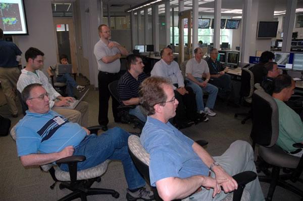
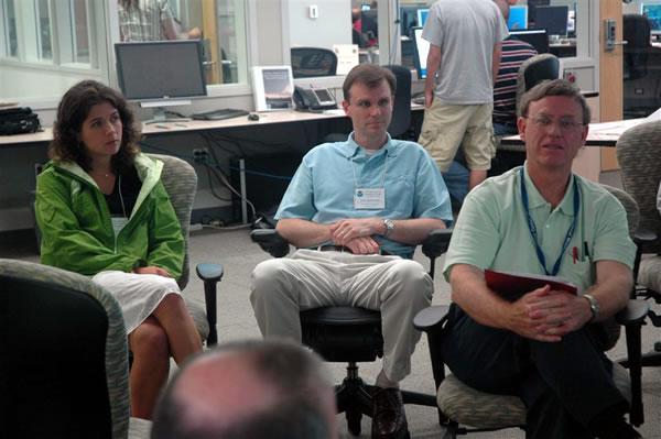
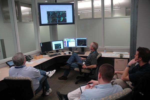
3 HWT Spring Experiment Daily Discussions (pictures from spring 2007)
4 Storm-Scale Convection-Permitting Ensemble and Convection-Resolving Deterministic Forecasting CAPS/OU provided CONUS-scale 4-km ensemble & 1-2 km high-res forecasts for HWT Spring Experiment since NSSL, EMC, NCAR, and GSD provided additional 3-4 km deterministic forecasts.
5 Scientific Issues to Address The values and cost-benefits of storm-scale versus coarserresolution short-range ensembles versus even-higherresolution deterministic forecast; Suitable perturbation methods for storm-scale ensemble, e.g., IC, physics, and model perturbations; Proper handling and use of boundary perturbations; The value and impact of assimilating high-res data including those from radars; The most effective ensemble post-processing and most useful products at the convective scales; The impact of such unique products on forecasting and warning.
6 Forecast Configurations of Four Years Spring 2007: 10-member WRF-ARW, 4 km, 33 h, 21Z start time, NAM+SREF ICs. 5 members physics perturbations only, 5 with Phy+IC+LBC perturbations. Single 2 km grid. 2/3 CONUS (Xue et al.; Kong et al.; 2007 NWP conf.) Spring 2008: larger domain, 00Z start, Phy+IC+LBC pert for all. Radar Vr and Z data assimilation for 4 and 2 km grids! (Xue et al.; Kong et al SLS Conf.) Spring 2009: 20 members, 4 km, 3 models (ARW, NMM, ARPS), mixed physics/ic/lbcs. Single 1 km grid. Radar DA on native grids. 30 h forecasts from 0Z (Xue et al.; Kong et al NWP Conf.) Spring 2010: 26 4-km and one 1-km forecasts. Full CONUS domain. Some members with physics difference only, and 3 with storm-scale and mesoscale IC perturbations only for studying error growth and predictability. About 1.5 months each spring season from mid-april through early June

7 Configuration of 2007 Ensemble WRF ARW Model at 4 km
8 Average Domain Total Precipitation Physics All members only members Native grids Ferrier/MYJ Thompson/YSU Stage II Obs WSM6/YSU (Schwartz et al. 2009a,b)

9 Areal Coverages Native grids WSM6/YSU Ferrier/MYJ Thompson/YSU
10 Domain-mean ensemble spread - averaged over 38 forecast dates from April 18 to June 7 (Kong et al. 2007) Local Standard Time:
11 Key Findings from 2007 Experiment Ferrier/MYJ schemes are associated with greater average precipitation YSU PBL scheme seems to be associated with relatively less precipitation, on average, in combination with WSM6 or Thompson microphysics Physics only members are under-dispersive for large-scale fields For precipitation, physics perturbations seem to generate as much spread as IC/LBC perturbations There is significant high bias for most members especially on the second day Convective-allowing ensemble clearly out-performs convectionparameterization ensemble in propagation, ETS, statistical consistency, ROC, etc. (Adam Clark s talk) 2 km forecasts didn t seem to provide much more value than 4 km forecasts for the second day guidance.
12 Forecast Configurations of Four Years Spring 2007: 10-member WRF-ARW, 4 km, 33 h, 21Z start time, NAM+SREF ICs. 5 members physics perturbations only, 5 with Phy+IC+LBC perturbations. Single 2 km grid. 2/3 CONUS (Xue et al.; Kong et al.; 2007 NWP conf.) Spring 2008: larger domain, 00Z start, Phy+IC+LBC pert for all. Radar Vr and Z data assimilation for 4 and 2 km grids! (Xue et al.; Kong et al SLS Conf.) Spring 2009: 20 members, 4 km, 3 models (ARW, NMM, ARPS), mixed physics/ic/lbcs. Single 1 km grid. Radar DA on native grids. 30 h forecasts from 0Z (Xue et al.; Kong et al NWP Conf.) Spring 2010: 26 4-km and one 1-km forecasts. Full CONUS domain. Some members with physics difference only, and 3 with storm-scale and mesoscale IC perturbations only for studying error growth and predictability (Xue et al. 2010; Kong et al SLS conf.). About 1.5 months each spring season from mid-april through early June

13 4 km ensemble and 2 km high-res domains 3600 x 2688 km

14 Movie of 2 km forecast v.s. observations 5 minute time intervals

15 Configuration of 4-km Ensemble
16 1-h accumulated precipitation 0.1in, t=12 h 0.01in, t=24 h
17 BIAS comparison 1-h accumulated precipitation 0.1 in
18 Bias correction based on first 12 days bias based on ranks for each hour (a) Sorted 1 h accumulated precipitation, and (b) differences between members and observation (bias) for the 24 h forecast, averaged over a 12-day period from April 16 to May 7, (Kong et al SLS)
19 Bias corrected (for the later 15 days) >0.01 in/h >0.1 in/h Probability matching (Ebert 2001) >0.5 in/h > 1.0 in/h
20 Rank histogram of 1 h accumulated precipitation for 18 h, and 24 h, averaged over 15 days of bias corrected dates 18 h 24h (not much improvement to the reliability though)
21 ETS comparison 1-h accumulated precipitation 0.1 in
22 Forecast Configurations of Four Years Spring 2007: 10-member WRF-ARW, 4 km, 33 h, 21Z start time, NAM+SREF ICs. 5 members physics perturbations only, 5 with Phy+IC+LBC perturbations. Single 2 km grid. 2/3 CONUS (Xue et al.; Kong et al.; 2007 NWP conf.) Spring 2008: larger domain, 00Z start, Phy+IC+LBC pert for all. Radar Vr and Z data assimilation for 4 and 2 km grids! (Xue et al.; Kong et al SLS Conf.) Spring 2009: 20 members, 4 km, 3 models (ARW, NMM, ARPS), mixed physics/ic/lbcs. Single 1 km grid. Radar DA on native grids. 30 h forecasts from 0Z (Xue et al.; Kong et al NWP Conf.) Spring 2010: 26 4-km and one 1-km forecasts. Full CONUS domain. Some members with physics difference only, and 3 with storm-scale and mesoscale IC perturbations only for studying error growth and predictability. About 1.5 months each spring season from mid-april through early June

23 ARPS 3DVAR Analysis Grid 1 km grid: 3603 x 2691 x 51 WRF ARW (4 and 1 km) and ARPS forecast grid and common post-processing grid WRF NMM forecast grid
24 ETS for 3-hourly Precip. 0.5 in from HWT Spring Forecast Experiments 2008 (32-day) 2009 (26-day) With radar With radar no radar 12 km NAM no radar 12 km NAM Probability-matched score generally better than any ensemble member 2 km score no-better than the best 4-km ensemble member may be due to physics 1-km score better than any 4-km member and than the 4 km PM score.
25 BIAS for 1 h precip of 2009 (24-day average) 0.1 inch/h
26 Reliability diagram for precipitation probability forecast Reliability is improved by using multiple models 12 h forecast of 1 h accumulated precip. 0.1in
 ARW ARPS NMM No Radar ARW ARPS NMM Microphysics PBL")
27 Object-Oriented Precipitation forecasts clusters (by Aaron Johnson) ARW ARPS NMM No Radar ARW ARPS NMM Microphysics PBL 4
28 Forecast Configurations of Four Years Spring 2007: 10-member WRF-ARW, 4 km, 33 h, 21Z start time, NAM+SREF ICs. 5 members physics perturbations only, 5 with Phy+IC+LBC perturbations. Single 2 km grid. 2/3 CONUS (Xue et al.; Kong et al.; 2007 NWP conf.) Spring 2008: larger domain, 00Z start, Phy+IC+LBC pert for all. Radar Vr and Z data assimilation for 4 and 2 km grids! (Xue et al.; Kong et al SLS Conf.) Spring 2009: 20 members, 4 km, 3 models (ARW, NMM, ARPS), mixed physics/ic/lbcs. Single 1 km grid. Radar DA on native grids. 30 h forecasts from 0Z (Xue et al.; Kong et al NWP Conf.) Spring 2010: 26 4-km and one 1-km forecasts. Full CONUS domain. Some members with physics difference only, and 3 with storm-scale and mesoscale IC perturbations only for studying error growth and predictability. About 1.5 months each spring season from mid-april through early June
29 2010 Spring Experiment Domains Full CONUS NMM 790x999 3DVAR 1200x780 ARW, ARPS & verification 1160x720
30 member IC BC Radar data microphy LSM PBL arw_cn 00Z ARPSa 00Z NAMf yes Thompson Noah MYJ arw_c0 00Z NAMa 00Z NAMf no Thompson Noah MYJ arw_m3 arw_cn + random pert 00Z NAMf yes Thompson Noah MYJ arw_m4 arw_cn + RF pert 00Z NAMf yes Thompson Noah MYJ arw_m5 arw_cn + em-p1 + RF pert 21Z SREF em-p1 yes Morrison RUC YSU arw_m6 arw_cn + em-p1_pert ARW member configuration (19) 21Z SREF em-p1 yes Morrison RUC YSU arw_m7 arw_cn + em-p2_pert 21Z SREF em-p2 yes Thompson Noah QNSE arw_m8 arw_cn nmm-p1_pert 21Z SREF nmm-p1 yes WSM6 RUC QNSE arw_m9 arw_cn + nmm-p2_pert 21Z SREF nmm-p2 yes WDM6 Noah MYNN arw_m10 arw_cn + rsmsas-n1_pert 21Z SREF rsmsas-n1 yes Ferrier RUC YSU arw_m11 arw_cn etakf-n1_pert 21Z SREF etakf-n1 yes Ferrier Noah YSU arw_m12 arw_cn + etakf-p1_pert 21Z SREF etakf-p1 yes WDM6 RUC QNSE arw_m13 arw_cn etabmj-n1_pert 21Z SREF etabmj-n1 yes WSM6 Noah MYNN arw_m14 arw_cn + etabmj-p1_pert 21Z SREF etabmj-p1 yes Thompson RUC MYNN arw_m15 00Z ARPSa 00Z NAMf yes WDM6 Noah MYJ arw_m16 00Z ARPSa 00Z NAMf yes WSM6 Noah MYJ arw_m17 00Z ARPSa 00Z NAMf yes Morrison Noah MYJ arw_m18 00Z ARPSa 00Z NAMf yes Thompson Noah QNSE arw_m19 00Z ARPSa 00Z NAMf yes Thompson Noah MYNN For all ARW members: ra_lw_physics= RRTM; ra_sw_physics=goddard; cu_physics=none
31 NMM member configuration (5) member IC BC Radar data mp_phy lw_phy sw-phy sf_phy nmm_cn 00Z ARPSa 00Z NAMf yes Ferrier GFDL GFDL Noah nmm_c0 00Z NAMa 00Z NAMf no Ferrier GFDL GFDL Noah nmm_m3 nmm_cn + nmmn1_pert 21Z SREF nmmn1 yes Thompson RRTM Dudhia Noah nmm_m4 nmm_cn + nmmn2_pert 21Z SREF nmmn2 yes WSM 6-class RRTM Dudhia RUC nmm_m5 nmm_cn + em-n1_pert 21Z SREF em-n1 yes Ferrier GFDL GFDL RUC For all NMM members: pbl_physics=myj; cu_physics=none ARPS member configuration (2) member IC BC Radar data Microphy. radiation sf_phy arps_cn 00Z ARPSa 00Z NAMf yes Lin Chou/Suarez Force-restore arps_c0 00Z NAMa 00Z NAMf no Lin Chou/Suarez Force-restore For all ARPS members: no cumulus parameterization Members in red contribute to the 15-member sub-ensemble for post-processed product

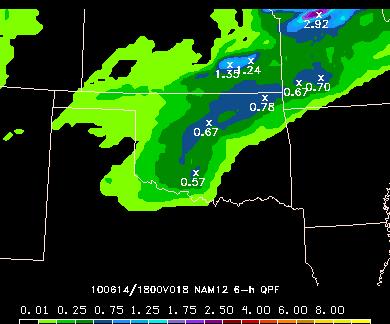
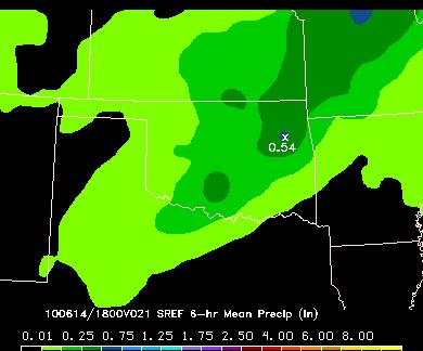
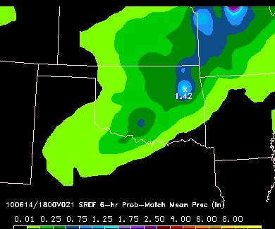
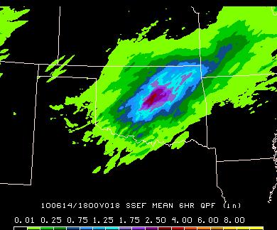

32 HWT images 12 18Z accumulated precipitation: 18h (June 14, 2010 OKC Flood Day) SSEF mean SSEF Prob match QPE SREF mean SREF Prob match NCEP 12 km NAM

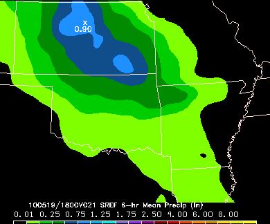
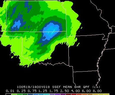
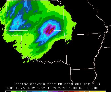
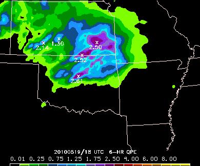
33 HWT images 12 18Z accumulated precipitation: 18h (May 19, 2010) SSEF mean SSEF Prob match QPE SREF mean SREF Prob match NAM

34 Gilbert Skill Scores (ETSs) for CAPS s SSEF (4 and 1 km) ESRL/GSD s 3 km HRRR NCEP 12 km NAM From 2010 spring experiment
35 Referred publications from the data Schwartz, C., J. Kain, S. Weiss, M. Xue, D. Bright, F. Kong, K. Thomas, J. Levit, and M. Coniglio, 2009: Next-day convection-allowing WRF model guidance: A second look at 2 vs. 4 km grid spacing. Mon. Wea. Rev., 137, Schwartz, C. S., J. S. Kain, S. J. Weiss, M. Xue, D. R. Bright, F. Kong, K. W.Thomas, J. J. Levit, M. C. Coniglio, and M. S. Wandishin, 2010: Toward improved convection-allowing ensembles: model physics sensitivities and optimizing probabilistic guidance with small ensemble membership. Wea. Forcasting, 25, Clark, A. J., W. A. Gallus, Jr., M. Xue, and F. Kong, 2009: A comparison of precipitation forecast skill between small near-convection-permitting and large convection-parameterizing ensembles. Wea. and Forecasting, 24, Clark, A. J., W. A. Gallus, Jr., M. Xue, and F. Kong, 2010: Growth of spread in convection-allowing and convection-parameterizing ensembles, In press. Clark, A. J., W. A. Gallus, Jr., M. Xue, and F. Kong, 2010: Convection-allowing and convectionparameterizing ensemble forecasts of a mesoscale convective vortex and associated severe weather. Wea. Forecasting, Accepted. Coniglio, M. C., K. L. Elmore, J. S. Kain, S. Weiss, and M. Xue, 2009: Evaluation of WRF model output for severe-weather forecasting from the 2008 NOAA Hazardous Weather Testbed Spring Experiment. Wea. Forcasting, Accepted. Kain, J. S., M. Xue, M. C. Coniglio, S. J. Weiss, F. Kong, T. L. Jensen, B. G. Brown, J. Gao, K. Brewster, K. W. Thomas, Y. Wang, C. S. Schwartz, and J. J. Levit, 2010: Assessing advances in the assimilation of radar data within a collaborative forecasting-research environment. Wea. Forecasting, Accepted.
36 Web links to papers and realtime products Xue, M., F. Kong, K. W. Thomas, J. Gao, Y. Wang, K. Brewster, K. K. Droegemeier, X. Wang, J. Kain, S. Weiss, D. Bright, M. Coniglio, and J. Du, 2009: CAPS realtime multi-model convection-allowing ensemble and 1-km convectionresolving forecasts for the NOAA Hazardous Weather Testbed 2009 Spring Experiment. 23nd Conf. Wea. Anal. Forecasting/19th Conf. Num. Wea. Pred., Omaha, NB, Amer. Meteor. Soc., Paper 16A.2. Kong, F. M. Xue, K. W. Thomas, J. Gao, Y. Wang, K. Brewster, K. K. Droegemeier, J. Kain, S. Weiss, D. Bright, M. Coniglio, and J. Du, 2009: A realtime storm-scale ensemble forecast system: 2009 spring experiment. 23nd Conf. Wea. Anal. Forecasting/19th Conf. Num. Wea. Pred., Omaha, NB, Amer. Meteor. Soc., Paper 16A.3.
37 Resources $125K/year CSTAR funding! NSF supercomputers. 18,000-core Cray XT-4 at NICS ~5 hours a day in 2010 All data archived (TBs/day) need to be fully exploited Collaboration in analyzing the data welcome.
38 Future Plan (in CSTAR Renewal Proposal) General direction: more emphasis on aviation weather (e.g., 3 weeks in June + May), more runs/day, shorter forecast ranges, fine-tuning of ensemble design, Multi-scale IC perturbations, ETKF perturbations, EnKF-based perturbations Land surface perturbations, Possible additional LBC perturbations, More intelligent choices of physics suites Addition of COAMPS Improved initial conditions via more advanced data assimilation Possible GSI analyses with target HRRR set up and other more experimental configurations/schemes Possible hybrid ensemble-gsi analysis Possible EnKF analysis Post-analysis and probabilistic products: e.g., calibration, bias removal, detailed performance evaluation, cost-benefit/trade off assessment, effective products for end users (e.g., those for aviation weather, severe storms); Integration/coordination with national mesoscale ensemble efforts (DTC/DET collaborations).

 is tracking along centerline of highest")

39 Probabilistic Warn-on-Forecast for Tornadoes - The ultimate challenge need ~100 m resolution Radar and Initial Forecast at 2100 CST Radar at 2130 CST: Accurate Forecast An ensemble of storm-scale NWP models predict the path of a potentially tornadic supercell during the next 1 hour. The ensemble is used to create probabilistic tornado guidance. Probabilistic tornado guidance: Forecast looks on track, storm circulation (hook echo) is tracking along centerline of highest tornadic probabilities Developing thunderstorm 50% 30% Most Likely Tornado Path 50% 30% Most Likely Tornado Path 70% 70% T=2200 CST T=2200 CST T=2120 CST T=2140 T=2130 T=2150 T=2120 CST T=2140 T=2130 T=2150 (Stensrud, Xue, et al. BAMS 2009) NSSL Warn on Forecast Briefing March 5, 2007

40 The Computers Used NICS, Kraken (~99K cores) For 2010: Exclusive use of a 18,000-core Cray XT-4 at NICS/University of Tennessee 6 hours a day PSC (4K cores) Thanks!
CAPS Storm-Scale Ensemble Forecasting (SSEF) System
 System") CAPS Storm-Scale Ensemble Forecasting (SSEF) System Fanyou Kong, Ming Xue, Xuguang Wang, Keith Brewster Center for Analysis and Prediction of Storms University of Oklahoma (collaborated with NSSL, SPC,
CAPS Storm-Scale Ensemble Forecasting (SSEF) System Fanyou Kong, Ming Xue, Xuguang Wang, Keith Brewster Center for Analysis and Prediction of Storms University of Oklahoma (collaborated with NSSL, SPC,
CAPS Storm-Scale Ensemble Forecast for the NOAA Hazardous Weather Testbed (HWT) Spring Experiment
 Spring Experiment") CAPS Storm-Scale Ensemble Forecast for the NOAA Hazardous Weather Testbed (HWT) Spring Experiment Fanyou Kong, Ming Xue, Kevin W. Thomas, Yunheng Wang, Keith Brewster, Xuguang Wang (Center for Analysis
CAPS Storm-Scale Ensemble Forecast for the NOAA Hazardous Weather Testbed (HWT) Spring Experiment Fanyou Kong, Ming Xue, Kevin W. Thomas, Yunheng Wang, Keith Brewster, Xuguang Wang (Center for Analysis
New Development in CAPS Storm-Scale Ensemble Forecasting System for NOAA 2012 HWT Spring Experiment
 New Development in CAPS Storm-Scale Ensemble Forecasting System for NOAA 2012 HWT Spring Experiment Fanyou Kong, Ming Xue, Kevin W. Thomas, Yunheng Wang, Keith Brewster, Xuguang Wang (Center for Analysis
2010 CAPS Spring Forecast Experiment Program Plan (A Brief Version)
") 21 CAPS Spring Forecast Experiment Program Plan (A Brief Version) May 17, 21 Table of Content Table of Content... 2 1. Overview of New Features for 21 Season... 3 2. Program Duration... 4 3. Forecast System
21 CAPS Spring Forecast Experiment Program Plan (A Brief Version) May 17, 21 Table of Content Table of Content... 2 1. Overview of New Features for 21 Season... 3 2. Program Duration... 4 3. Forecast System
457 EVALUATION OF CAPS MULTI-MODEL STORM-SCALE ENSEMBLE FORECAST FOR THE NOAA HWT 2010 SPRING EXPERIMENT
 24th Conference on Weather and Forecasting/20th Conference on Numerical Weather Prediction. AMS, Seattle, WA, January 23-27, 2011. 457 EVALUATION OF CAPS MULTI-MODEL STORM-SCALE ENSEMBLE FORECAST FOR THE
A Cycled GSI+EnKF and Storm-Scale Ensemble Forecasting (SSEF) Experiment
 Experiment") A Cycled GSI+EnKF and Storm-Scale Ensemble Forecasting (SSEF) Experiment Fanyou Kong, Ming Xue, Youngsun Jung, Keith A. Brewster, Gang Zhao Center for Analysis and Prediction of Storms University of Oklahoma
A Cycled GSI+EnKF and Storm-Scale Ensemble Forecasting (SSEF) Experiment Fanyou Kong, Ming Xue, Youngsun Jung, Keith A. Brewster, Gang Zhao Center for Analysis and Prediction of Storms University of Oklahoma
University of Oklahoma 3 National Severe Storms Laboratory, NOAA 4 Storm Prediction Center/NCEP, NOAA
 Extended Abstract, 25th Conference on Severe Local Storms Amer. Meteor. Soc., Denver, Colorado, October 11-14 7B.3 CAPS REALTIME STORM-SCALE ENSEMBLE AND CONVECTION-RESOLVING HIGH-RESOLUTION FORECASTS
CAPS STORMSCALE ENSEMBLE FORECASTING SYSTEM: IMPACT OF IC AND LBC PERTURBATIONS
 $%& ' ( ) %$* +, % - '.&/! CAPS STORMSCALE ENSEMBLE FORECASTING SYSTEM: IMPACT OF IC AND LBC PERTURBATIONS Fanyou Kong 1 *, Ming Xue 1,2, Kevin W. Thomas 1, Yunheng Wang 1, Keith A. Brewster 1, Youngsun
Aaron Johnson* and Xuguang Wang. University of Oklahoma School of Meteorology and Center for Analysis and Prediction of Storms (CAPS), Norman, OK
, Norman, OK") 3.1 VERIFICATION AND CALIBRATION OF PROBABILISTIC PRECIPITATION FORECASTS DERIVED FROM NEIGHBORHOOD AND OBJECT BASED METHODS FOR A MULTI-MODEL CONVECTION-ALLOWING ENSEMBLE Aaron Johnson* and Xuguang Wang
3.1 VERIFICATION AND CALIBRATION OF PROBABILISTIC PRECIPITATION FORECASTS DERIVED FROM NEIGHBORHOOD AND OBJECT BASED METHODS FOR A MULTI-MODEL CONVECTION-ALLOWING ENSEMBLE Aaron Johnson* and Xuguang Wang
32 AN OVERVIEW OF CAPS STORMSCALE ENSEMBLE FORECAST FOR THE 2015 NOAA HWT SPRING FORECASTING EXPERIMENT
 !"# #$%#&'(&#)*+ 32 AN OVERVIEW OF CAPS STORMSCALE ENSEMBLE FORECAST FOR THE 2015 NOAA HWT SPRING FORECASTING EXPERIMENT Fanyou Kong 1 *, Ming Xue 1,2, Youngsun Jung 1, Keith A. Brewster 1, Kevin W. Thomas
University of Oklahoma, Norman, OK INTRODUCTION
 Preprints, 22th Conf. on Weather Analysis and Forecasting and 18th Conf. on Numerical Weather Prediction Amer. Meteor. Soc., Park City, UT, 25-29 June 2007 3B.2 PRELIMINARY ANALYSIS ON THE REAL-TIME STORM-SCALE
Comparison of Convection-permitting and Convection-parameterizing Ensembles
 Comparison of Convection-permitting and Convection-parameterizing Ensembles Adam J. Clark NOAA/NSSL 18 August 2010 DTC Ensemble Testbed (DET) Workshop Introduction/Motivation CAMs could lead to big improvements
P9.3 AN OPERATIONAL APPROACH FOR INTEGRATING MULTIPLE HIGH RESOLUTION MODEL SOLUTIONS DURING A HIGH IMPACT EVENT: THE 22 MAY 2010 EF4 BOWDLE TORNADO
 P9.3 AN OPERATIONAL APPROACH FOR INTEGRATING MULTIPLE HIGH RESOLUTION MODEL SOLUTIONS DURING A HIGH IMPACT EVENT: THE 22 MAY 2010 EF4 BOWDLE TORNADO 1. INTRODUCTION Michael A. Fowle * NOAA/NWS, Aberdeen,
12.2 CAPS REALTIME STORM-SCALE ENSEMBLE AND HIGH-RESOLUTION FORECASTS AS PART OF THE NOAA HAZARDOUS WEATHER TESTBED 2008 SPRING EXPERIMENT
 Extended Abstract, 224h Conf. on Severe Local Storms Amer. Meteor. Soc., Savannah, Georgia, October 26-31, 2008 12.2 CAPS REALTIME STORM-SCALE ENSEMBLE AND HIGH-RESOLUTION FORECASTS AS PART OF THE NOAA
School of Meteorology, University of Oklahoma, and Center for Analysis and Prediction of Storms, Norman, Oklahoma FANYOU KONG
 3694 M O N T H L Y W E A T H E R R E V I E W VOLUME 139 Hierarchical Cluster Analysis of a Convection-Allowing Ensemble during the Hazardous Weather Testbed 2009 Spring Experiment. Part II: Ensemble Clustering
Aaron Johnson School of Meteorology, University of Oklahoma and Center for Analysis and Prediction of Storms, Norman, Oklahoma
 Hierarchical cluster analysis of a convection-allowing ensemble during the Hazardous Weather Testbed 2009 Spring Experiment. Part II: Ensemble clustering over the whole experiment period Aaron Johnson
Probabilistic Precipitation Forecast Skill as a Function of Ensemble Size and Spatial Scale in a Convection-Allowing Ensemble
 1410 M O N T H L Y W E A T H E R R E V I E W VOLUME 139 Probabilistic Precipitation Forecast Skill as a Function of Ensemble Size and Spatial Scale in a Convection-Allowing Ensemble ADAM J. CLARK,* JOHN
Norman Oklahoma Submitted to Advances in Meteorology. May 2013 Revised November, Corresponding author address
 Prediction of Convective Storms at Convection-Resolving 1 km Resolution over Continental United States with Radar Data Assimilation: An Example Case of 26 May 2008 Ming Xue 1, Fanyou Kong 1, Kevin W. Thomas
Forecasting Tornado Pathlengths Using a Three-Dimensional Object Identification Algorithm Applied to Convection-Allowing Forecasts
 1090 W E A T H E R A N D F O R E C A S T I N G VOLUME 27 Forecasting Tornado Pathlengths Using a Three-Dimensional Object Identification Algorithm Applied to Convection-Allowing Forecasts ADAM J. CLARK,*,1
Object-based evaluation of the impact of horizontal grid spacing on convection-allowing forecasts
 Object-based evaluation of the impact of horizontal grid spacing on convection-allowing forecasts Aaron Johnson School of Meteorology, University of Oklahoma and Center for Analysis and Prediction of Storms,
School of Meteorology, University of Oklahoma, and Center for Analysis and Prediction of Storms, Norman, Oklahoma FANYOU KONG
 VOLUME 139 M O N T H L Y W E A T H E R R E V I E W DECEMBER 2011 Hierarchical Cluster Analysis of a Convection-Allowing Ensemble during the Hazardous Weather Testbed 2009 Spring Experiment. Part I: Development
Verifying Ensemble Forecasts Using A Neighborhood Approach
 Verifying Ensemble Forecasts Using A Neighborhood Approach Craig Schwartz NCAR/MMM schwartz@ucar.edu Thanks to: Jack Kain, Ming Xue, Steve Weiss Theory, Motivation, and Review Traditional Deterministic
OPTIMIZING PROBABILISTIC HIGH-RESOLUTION ENSEMBLE GUIDANCE FOR HYDROLOGIC PREDICTION
 9.4 OPTIMIZING PROBABILISTIC HIGH-RESOLUTION ENSEMBLE GUIDANCE FOR HYDROLOGIC PREDICTION Craig S. Schwartz* 1, John S. Kain 2, Steven J. Weiss 3, Ming Xue 1,4, David R. Bright 3, Fanyou Kong 4, Kevin W.
Evaluation of WRF Model Output for Severe Weather Forecasting from the 2008 NOAA Hazardous Weather Testbed Spring Experiment
 408 W E A T H E R A N D F O R E C A S T I N G VOLUME 25 Evaluation of WRF Model Output for Severe Weather Forecasting from the 2008 NOAA Hazardous Weather Testbed Spring Experiment MICHAEL C. CONIGLIO,
A GSI-based convection-allowing EnKF and ensemble forecast system for PECAN
 A GSI-based convection-allowing EnKF and ensemble forecast system for PECAN Aaron Johnson, Xuguang Wang, Samuel Degelia University of Oklahoma, Norman, OK 26 May 2016 7 th EnKF Data Assimilation Workshop,
Convection-Resolving NWP with WRF. Section coordinator Ming Xue University of Oklahoma
 Convection-Resolving NWP with WRF Section coordinator Ming Xue University of Oklahoma Convection-resolving NWP Is NWP that explicitly treats moist convective systems ranging from organized MCSs to individual
Chengsi Liu 1, Ming Xue 1, 2, Youngsun Jung 1, Lianglv Chen 3, Rong Kong 1 and Jingyao Luo 3 ISDA 2019
 Development of Optimized Radar Data Assimilation Capability within the Fully Coupled EnKF EnVar Hybrid System for Convective Permitting Ensemble Forecasting and Testing via NOAA Hazardous Weather Testbed
10.1 AN OVERVIEW OF THE 2012 NOAA HAZARDOUS WEATHER TESTBED SPRING FORECASTING EXPERIMENT
 10.1 AN OVERVIEW OF THE 2012 NOAA HAZARDOUS WEATHER TESTBED SPRING FORECASTING EXPERIMENT John S. Kain,* I. L. Jirak, + A. J. Clark, #, * M. C. Coniglio,* S. J. Weiss, + J. Correia Jr., #,+ A. R. Dean,
Tornado Pathlength Forecasts from 2010 to 2011 Using Ensemble Updraft Helicity
 APRIL 2013 C L A R K E T A L. 387 Tornado Pathlength Forecasts from 2010 to 2011 Using Ensemble Updraft Helicity ADAM J. CLARK,*,1 JIDONG GAO, 1 PATRICK T. MARSH,*,1,# TRAVIS SMITH,*,1 JOHN S. KAIN, 1
Amy Harless. Jason Levit, David Bright, Clinton Wallace, Bob Maxson. Aviation Weather Center Kansas City, MO
 Amy Harless Jason Levit, David Bright, Clinton Wallace, Bob Maxson Aviation Weather Center Kansas City, MO AWC Mission Decision Support for Traffic Flow Management Ensemble Applications at AWC Testbed
Growth of Spread in Convection-Allowing and Convection-Parameterizing Ensembles
 Geological and Atmospheric Sciences Publications Geological and Atmospheric Sciences 2010 Growth of Spread in Convection-Allowing and Convection-Parameterizing Ensembles Adam J. Clark Iowa State University
THE DECORRELATION SCALE: METHODOLOGY AND APPLICATION FOR PRECIPITATION FORECASTS
 THE DECORRELATION SCALE: METHODOLOGY AND APPLICATION FOR PRECIPITATION FORECASTS Madalina Surcel, Isztar Zawadzki and M. K. Yau Thanking Adam Clark (NSSL), Ming Xue (OU, CAPS) and Fanyou Kong (CAPS) for
Center for Analysis and Prediction of Storms 1 and School of Meteorology 2 University of Oklahoma, Norman, OK 73072
 Evaluation of Convection-Permitting Precipitation Forecast Products using WRF, NMMB, and FV3 for the 2016-2017 NOAA Hydrometeorology Testbed Flash Flood and Intense Rainfall Experiments Nathan Snook 1,
10.3 PROBABILISTIC FORECASTS OF LOCATION AND TIMING OF CONVECTION DURING THE 2012 NOAA HAZARDOUS WEATHER TESTBED SPRING FORECASTING EXPERIMENT
 10.3 PROBABILISTIC FORECASTS OF LOCATION AND TIMING OF CONVECTION DURING THE 2012 NOAA HAZARDOUS WEATHER TESTBED SPRING FORECASTING EXPERIMENT Stuart D. Miller, Jr.*,3,4,6, John S. Kain 1, Patrick T. Marsh
1. INTRODUCTION 3. PROJECT DATAFLOW
 P10.5 THE NOAA HAZARDOUS WEATHER TESTBED 2008 SPRING EXPERIMENT: TECHINCAL AND SCIENTIFIC CHALLENGES OF CREATING A DATA VISUALIZATION ENVIRONMENT FOR STORM- SCALE DETERMINISTIC AND ENSEMBLE FORECASTS Jason
Advanced Multi-Moment Microphysics for Precipitation and Tropical Cyclone Forecast Improvement within COAMPS
 DISTRIBUTION STATEMENT A. Approved for public release; distribution is unlimited. Advanced Multi-Moment Microphysics for Precipitation and Tropical Cyclone Forecast Improvement within COAMPS PI: Ming Xue
Canadian Meteorological and Oceanographic Society and American Meteorological Society 21 st Conference on Numerical Weather Prediction 31 May 2012
 Canadian Meteorological and Oceanographic Society and American Meteorological Society 21 st Conference on Numerical Weather Prediction 31 May 2012 The High Resolution Rapid Refresh (): An hourly updating
Dynamic Ensemble Model Evaluation of Elevated Thunderstorms sampled by PRECIP
 Dynamic Ensemble Model Evaluation of Elevated Thunderstorms sampled by PRECIP Joshua S. Kastman, Patrick S. Market, and Neil Fox, University of Missouri, Columbia, MO Session 8B - Numerical Weather Prediction
Using Convection-Allowing Models to Produce Forecast Guidance For Severe Thunderstorm Hazards via a Surrogate-Severe Approach!
 Using Convection-Allowing Models to Produce Forecast Guidance For Severe Thunderstorm Hazards via a Surrogate-Severe Approach! Ryan Sobash! University of Oklahoma, School of Meteorology, Norman, OK! J.
Introduction to NCEP's time lagged North American Rapid Refresh Ensemble Forecast System (NARRE-TL)
") Introduction to NCEP's time lagged North American Rapid Refresh Ensemble Forecast System (NARRE-TL) Binbin Zhou 1,2, Jun Du 2, Geoff Manikin 2 & Geoff DiMego 2 1. I.M. System Group 2. EMC/NCEP/NWS/NOAA
Introduction to NCEP's time lagged North American Rapid Refresh Ensemble Forecast System (NARRE-TL) Binbin Zhou 1,2, Jun Du 2, Geoff Manikin 2 & Geoff DiMego 2 1. I.M. System Group 2. EMC/NCEP/NWS/NOAA
Plans for NOAA s regional ensemble systems: NARRE, HRRRE, and a regional hybrid assimilation
 NOAA Earth System Research Laboratory Plans for NOAA s regional ensemble systems: NARRE, HRRRE, and a regional hybrid assimilation Tom Hamill (substituting for Stan Benjamin and team) NOAA Earth System
The Developmental Testbed Center (DTC) Steve Koch, NOAA/FSL
 Steve Koch, NOAA/FSL") The Developmental Testbed Center (DTC) Steve Koch, NOAA/FSL A facility where the NWP research and operational communities interact to accelerate testing and evaluation of new models and techniques for
The Developmental Testbed Center (DTC) Steve Koch, NOAA/FSL A facility where the NWP research and operational communities interact to accelerate testing and evaluation of new models and techniques for
HPC Ensemble Uses and Needs
 1 HPC Ensemble Uses and Needs David Novak Science and Operations Officer With contributions from Keith Brill, Mike Bodner, Tony Fracasso, Mike Eckert, Dan Petersen, Marty Rausch, Mike Schichtel, Kenneth
J11.4 IN SEARCH OF CI: LESSONS LEARNED FROM APPLYING PROXIES TO CI IN CONVECTION-ALLOWING MODELS
 J11.4 IN SEARCH OF CI: LESSONS LEARNED FROM APPLYING PROXIES TO CI IN CONVECTION-ALLOWING MODELS Stuart D. Miller, Jr. 1,2,3, John S. Kain 3 *, Patrick T. Marsh 4, Adam J. Clark 2,3, Michael C. Coniglio
SPC Ensemble Applications: Current Status and Future Plans
 : Current Status and Future Plans Israel Jirak Science Support Branch Storm Prediction Center Norman, OK Acknowledgments: Steve Weiss, Andy Dean, Gregg Grosshans, and Chris Melick Outline Large-Scale Guidance:
Extracting probabilistic severe weather guidance from convection-allowing model forecasts. Ryan Sobash 4 December 2009 Convection/NWP Seminar Series
 Extracting probabilistic severe weather guidance from convection-allowing model forecasts Ryan Sobash 4 December 2009 Convection/NWP Seminar Series Identification of severe convection in high-resolution
Convection-Allowing Models (CAMs) A discussion on Creating a Roadmap to a Unified CAM-based Data-Assimilation and Forecast Ensemble
 A discussion on Creating a Roadmap to a Unified CAM-based Data-Assimilation and Forecast Ensemble") Convection-Allowing Models (CAMs) A discussion on Creating a Roadmap to a Unified CAM-based Data-Assimilation and Forecast Ensemble Panel Members Curtis Alexander (ESRL/GSD) Adam Clark (NSSL) Lucas Harris
Convection-Allowing Models (CAMs) A discussion on Creating a Roadmap to a Unified CAM-based Data-Assimilation and Forecast Ensemble Panel Members Curtis Alexander (ESRL/GSD) Adam Clark (NSSL) Lucas Harris
A Look at the NSSL-WRF Forecast Output for the Violent Tornado Events in Central Oklahoma on May 19 and 20, 2013
 A Look at the NSSL-WRF Forecast Output for the Violent Tornado Events in Central Oklahoma on May 19 and 20, 2013 David A. Imy, NOAA SPC, emeritus and Adam J. Clark, CIMMS/NSSL, Norman, OK 1. Introduction
P1.36 IMPACT OF MESOSCALE DATA, CLOUD ANALYSIS ON THE EXPLICIT PREDICTION OF AN MCS DURING IHOP Daniel T. Dawson II and Ming Xue*
 P1.36 IMPACT OF MESOSCALE DATA, CLOUD ANALYSIS ON THE EXPLICIT PREDICTION OF AN MCS DURING IHOP 2002 Daniel T. Dawson II and Ming Xue* School of Meteorology and Center for the Analysis and Prediction of
Aaron Johnson School of Meteorology, University of Oklahoma and Center for Analysis and Prediction of Storms, Norman, Oklahoma
 Hierarchical cluster analysis of a convection-allowing ensemble during the Hazardous Weather Testbed 2009 Spring Experiment. Part I: Development of object-oriented cluster analysis method for precipitation
Development of an Hourly- Updated NAM Forecast System
 Development of an Hourly- Updated NAM Forecast System Jacob Carley ab, Eric Rogers b, Shun Liu ab, Brad Ferrier ab, Eric Aligo ab, Matthew Pyle b, and Geoff DiMego b a IMSG, b NOAA/NWS/NCEP/EMC jacob.carley@noaa.gov
VERIFICATION OF PROXY STORM REPORTS DERIVED FROM ENSEMBLE UPDRAFT HELICITY
 VERIFICATION OF PROXY STORM REPORTS DERIVED FROM ENSEMBLE UPDRAFT HELICITY MALLORY ROW 12,JAMES CORRIEA JR. 3, AND PATRICK MARSH 3 1 National Weather Center Research Experiences for Undergraduates Program
Air Force Weather Ensembles
 16 th Weather Squadron Air Force Weather Ensembles Evan Kuchera Fine Scale Models and Ensemble 16WS/WXN evan.kuchera@us.af.mil Overview n Air Force Weather Operational Ensembles n Probabilistic inline
15A.2 Some Challenges And Successes Associated with Using Storm-Scale Modeling at a NWS Forecast Office. Alexander Tardy 1
 15A.2 Some Challenges And Successes Associated with Using Storm-Scale Modeling at a NWS Forecast Office Alexander Tardy 1 1 NOAA/NWS/Weather Forecast Office, Corpus Christi, Texas 1. INTRODUCTION At the
P1.89 COMPARISON OF IMPACTS OF WRF DYNAMIC CORE, PHYSICS PACKAGE, AND INITIAL CONDITIONS ON WARM SEASON RAINFALL FORECASTS
 P1.89 COMPARISON OF IMPACTS OF WRF DYNAMIC CORE, PHYSICS PACKAGE, AND INITIAL CONDITIONS ON WARM SEASON RAINFALL FORECASTS William A. Gallus, Jr. Iowa State University, Ames, Iowa 1. INTRODUCTION A series
Using the LEAD Portal for Customized Weather Forecasts on the TeraGrid
 Using the LEAD Portal for Customized Weather Forecasts on the TeraGrid Keith Brewster Center for Analysis and Prediction of Storms, Univ. of Oklahoma Dan Weber, Suresh Marru, Kevin Thomas, Dennis Gannon,
WEATHER RESEARCH AND FORECASTING MODEL SENSITIVITY COMPARISONS FOR WARM SEASON CONVECTIVE INITIATION
 JA. WEATHER RESEARCH AND FORECASTING MODEL SENSITIVITY COMPARISONS FOR WARM SEASON CONVECTIVE INITIATION Leela R. Watson* Applied Meteorology Unit, ENSCO, Inc., Cocoa Beach, FL Brian Hoeth NOAA NWS Spaceflight
2012 and changes to the Rapid Refresh and HRRR weather forecast models
 2012 and 2013-15 changes to the Rapid Refresh and HRRR weather forecast models 31 October 2012 Stan Benjamin Steve Weygandt Curtis Alexander NOAA Earth System Research Laboratory Boulder, CO FPAW - 2012
Weather Hazard Modeling Research and development: Recent Advances and Plans
 Weather Hazard Modeling Research and development: Recent Advances and Plans Stephen S. Weygandt Curtis Alexander, Stan Benjamin, Geoff Manikin*, Tanya Smirnova, Ming Hu NOAA Earth System Research Laboratory
Convective-scale Warn-on-Forecast The Future of Severe Weather Warnings in the USA?
 Convective-scale Warn-on-Forecast The Future of Severe Weather Warnings in the USA? David J. Stensrud Department of Meteorology The Pennsylvania State University Present Warning System: 2 March 2012 Warning
Use of the LEAD Portal for On-Demand Severe Weather Prediction
 Use of the LEAD Portal for On-Demand Severe Weather Prediction Keith A. Brewster *1 ; and Daniel B. Weber 1, Kevin W. Thomas 1, Kelvin K. Droegemeier 1,2, Yunheng Wang 1, Ming Xue 1,2, Suresh Marru 3,
4.5 A WRF-DART study of the nontornadic and tornadic supercells intercepted by VORTEX2 on 10 June 2010
 4.5 A WRF-DART study of the nontornadic and tornadic supercells intercepted by VORTEX2 on 10 June 2010 ALICIA M. KLEES AND YVETTE P. RICHARDSON The Pennsylvania State University, University Park, Pennsylvania.
ENSEMBLE FORECASTS AND VERIFICATION OF THE MAY 2015 MULTI-HAZARD SEVERE WEATHER EVENT IN OKLAHOMA. Austin Coleman 1, Nusrat Yussouf 2
 ENSEMBLE FORECASTS AND VERIFICATION OF THE MAY 2015 MULTI-HAZARD SEVERE WEATHER EVENT IN OKLAHOMA Austin Coleman 1, Nusrat Yussouf 2 1 National Weather Center Research Experience for Undergraduates Program,
Development of High-Resolution Rapid Refresh (HRRR) Ensemble Data Assimilation, Forecast and Post-Processing
 Ensemble Data Assimilation, Forecast and Post-Processing") CORP Science Symposium, July 18-19, 2016, Fort Collins Development of High-Resolution Rapid Refresh (HRRR) Ensemble Data Assimilation, Forecast and Post-Processing Isidora Jankov, Curtis Alexander, David
CORP Science Symposium, July 18-19, 2016, Fort Collins Development of High-Resolution Rapid Refresh (HRRR) Ensemble Data Assimilation, Forecast and Post-Processing Isidora Jankov, Curtis Alexander, David
Transition of Research to Operations
 Transition of Research to Operations Ligia Bernardet Shaowu Bao, Mrinal Biswas, Tim Brown, Don Stark, Laurie Carson http://www.dtcenter.org/hurrwrf/users External collaborators: NOAA Environmental Modeling
Evaluation of WRF model output for severe-weather forecasting from the 2008 NOAA. Hazardous Weather Testbed Spring Experiment
 Evaluation of WRF model output for severe-weather forecasting from the 2008 NOAA Hazardous Weather Testbed Spring Experiment Michael C. Coniglio, Kimberly L. Elmore, John S. Kain NOAA/OAR/National Severe
Motivation & Goal. We investigate a way to generate PDFs from a single deterministic run
 Motivation & Goal Numerical weather prediction is limited by errors in initial conditions, model imperfections, and nonlinearity. Ensembles of an NWP model provide forecast probability density functions
Background. Each spring during the climatological. An Overview of the Experimental Forecast
 An Overview of the 2010 Hazardous Weather Testbed Experimental Forecast Program Spring Experiment by Ad a m J. Cl a r k, St e v e n J. Weiss, Joh n S. Ka i n, Is r a e l L. Ji r a k, Mi c h a e l Co n
Some Applications of WRF/DART
 Some Applications of WRF/DART Chris Snyder, National Center for Atmospheric Research Mesoscale and Microscale Meteorology Division (MMM), and Institue for Mathematics Applied to Geoscience (IMAGe) WRF/DART
J11.1 AN OVERVIEW OF THE 2013 NOAA HAZARDOUS WEATHER TESTBED SPRING FORECASTING EXPERIMENT
 J11.1 AN OVERVIEW OF THE 2013 NOAA HAZARDOUS WEATHER TESTBED SPRING FORECASTING EXPERIMENT Israel L. Jirak 1*, Michael Coniglio 2, Adam J. Clark 2,3, James Correia Jr. 1,3, Kent H. Knopfmeier 2,3, Christopher
Aaron Johnson 1,2, Xuguang Wang 1,2
 1 2 3 4 5 6 7 8 9 10 11 12 13 14 15 16 17 18 19 20 21 22 23 24 25 26 27 28 29 30 31 32 33 34 35 36 37 38 39 40 41 42 43 44 45 46 47 Multiscale characteristics and evolution of perturbations for warm season
Study of the impacts of grid spacing and physical parameterizations on WRF simulations of convective system rainfall and morphology
 Study of the impacts of grid spacing and physical parameterizations on WRF simulations of convective system rainfall and morphology Introduction Report on WRF-DTC Visit of W. Gallus, I. Jankov and E. Aligo
Final Report on. Evaluating the new Weather Research and Forecasting (WRF) model at the Storm Prediction Center
 model at the Storm Prediction Center") Final Report on Evaluating the new Weather Research and Forecasting (WRF) model at the Storm Prediction Center John S. Kain, Michael E. Baldwin, Steven J. Weiss, Frederick H. Carr, Geoffrey J. DiMego Time
Final Report on Evaluating the new Weather Research and Forecasting (WRF) model at the Storm Prediction Center John S. Kain, Michael E. Baldwin, Steven J. Weiss, Frederick H. Carr, Geoffrey J. DiMego Time
Developmental Testbed Center Visitor Program Final Report: Development and Application of 3-Dimensional Object Algorithms to High Resolution Forecasts
 Developmental Testbed Center Visitor Program Final Report: Development and Application of 3-Dimensional Object Algorithms to High Resolution Forecasts Adam J. Clark Cooperative Institute for Mesoscale
A Comparison of Precipitation Forecast Skill between Small Near-Convection- Permitting and Large Convection-Parameterizing Ensembles
 A Comparison of Precipitation Forecast Skill between Small Near-Convection- Permitting and Large Convection-Parameterizing Ensembles Adam J. Clark* 1, William A. Gallus Jr. 1, Ming Xue 2,3, and Fanyou
THE IMPACT OF DIFFERENT DATA FIELDS ON STORM-SSCALE DATA ASSIMILATION
 JP1J.3 THE IMPACT OF DIFFERENT DATA FIELDS ON STORM-SSCALE DATA ASSIMILATION Guoqing Ge 1,2,*, Jidong Gao 1, Kelvin Droegemeier 1,2 Center for Analysis and Prediction of Storms, University of Oklahoma,
David Dowell, Glen Romine, and Chris Snyder National Center for Atmospheric Research *, Boulder, CO. (a) CONUS domain
 CONUS domain") 9.5 ENSEMBLE STORM-SCALE DATA ASSIMILATION AND PREDICTION FOR SEVERE CONVECTIVE STORMS David Dowell, Glen Romine, and Chris Snyder National Center for Atmospheric Research *, Boulder, CO 1. INTRODUCTION
9.5 ENSEMBLE STORM-SCALE DATA ASSIMILATION AND PREDICTION FOR SEVERE CONVECTIVE STORMS David Dowell, Glen Romine, and Chris Snyder National Center for Atmospheric Research *, Boulder, CO 1. INTRODUCTION
Overview of HFIP FY10 activities and results
 Overview of HFIP FY10 activities and results Bob Gall HFIP Annual Review Meeting Miami Nov 9, 2010 Outline In this presentation I will show a few preliminary results from the summer program. More detail
PSU HFIP 2010 Summary: Performance of the ARW-EnKF Real-time Cloud-resolving TC Ensemble Analysis and Forecasting System.
 PSU HFIP 2010 Summary: Performance of the ARW-EnKF Real-time Cloud-resolving TC Ensemble Analysis and Forecasting System Fuqing Zhang Penn State University Contributors: Yonghui Weng, John Gamache and
46 AN OVERVIEW OF THE 2014 NOAA HAZARDOUS WEATHER TESTBED SPRING FORECASTING EXPERIMENT
 46 AN OVERVIEW OF THE 2014 NOAA HAZARDOUS WEATHER TESTBED SPRING FORECASTING EXPERIMENT Israel L. Jirak 1*, Michael Coniglio 2, Adam J. Clark 2,3, James Correia Jr. 1,3, Kent H. Knopfmeier 2,3, Christopher
Di Wu, Xiquan Dong, Baike Xi, Zhe Feng, Aaron Kennedy, and Gretchen Mullendore. University of North Dakota
 Di Wu, Xiquan Dong, Baike Xi, Zhe Feng, Aaron Kennedy, and Gretchen Mullendore University of North Dakota Objectives 3 case studies to evaluate WRF and NAM performance in Oklahoma (OK) during summer 2007,
HMON (HNMMB): Development of a new Hurricane model for NWS/NCEP operations
: Development of a new Hurricane model for NWS/NCEP operations") 1 HMON (HNMMB): Development of a new Hurricane model for NWS/NCEP operations Avichal Mehra, EMC Hurricane and Mesoscale Teams Environmental Modeling Center NOAA / NWS / NCEP HMON: A New Operational Hurricane
1 HMON (HNMMB): Development of a new Hurricane model for NWS/NCEP operations Avichal Mehra, EMC Hurricane and Mesoscale Teams Environmental Modeling Center NOAA / NWS / NCEP HMON: A New Operational Hurricane
The WRF Developmental Testbed Center (DTC)
") The WRF Developmental Testbed Center (DTC) Bob Gall A facility where the NWP research and operational communities interact to accelerate testing and evaluation of new models and techniques for research
The WRF Developmental Testbed Center (DTC) Bob Gall A facility where the NWP research and operational communities interact to accelerate testing and evaluation of new models and techniques for research
The Effects of High Resolution Model Output on Severe Weather Forecasts as Evaluated in the SPC/NSSL Spring Program 2004
 The Effects of High Resolution Model Output on Severe Weather Forecasts as Evaluated in the SPC/NSSL Spring Program 2004 Adam French National Weather Center Research Experience for Undergraduates Valparaiso
Implementation and evaluation of cloud analysis with WSR-88D reflectivity data for GSI and WRF-ARW
 Click Here for Full Article GEOPHYSICAL RESEARCH LETTERS, VOL. 34, L07808, doi:10.1029/2006gl028847, 2007 Implementation and evaluation of cloud analysis with WSR-88D reflectivity data for GSI and WRF-ARW
Toward improved initial conditions for NCAR s real-time convection-allowing ensemble. Ryan Sobash, Glen Romine, Craig Schwartz, and Kate Fossell
 Toward improved initial conditions for NCAR s real-time convection-allowing ensemble Ryan Sobash, Glen Romine, Craig Schwartz, and Kate Fossell Storm-scale ensemble design Can an EnKF be used to initialize
Thunderstorm-Scale EnKF Analyses Verified with Dual-Polarization, Dual-Doppler Radar Data
 Thunderstorm-Scale EnKF Analyses Verified with Dual-Polarization, Dual-Doppler Radar Data David Dowell and Wiebke Deierling National Center for Atmospheric Research, Boulder, CO Ensemble Data Assimilation
COMET Cooperative Project Final Report. Name of University Researcher Preparing Report: Michael Baldwin
 University: Purdue University COMET Cooperative Project Final Report Name of University Researcher Preparing Report: Michael Baldwin NWS Offices: NWSFO Indianapolis, IN, NWSFO North Webster, IN, NCEP/Storm
Numerical Weather Prediction: Data assimilation. Steven Cavallo
 Numerical Weather Prediction: Data assimilation Steven Cavallo Data assimilation (DA) is the process estimating the true state of a system given observations of the system and a background estimate. Observations
Report on EN6 DTC Ensemble Task 2014: Preliminary Configuration of North American Rapid Refresh Ensemble (NARRE)
") Report on EN6 DTC Ensemble Task 2014: Preliminary Configuration of North American Rapid Refresh Ensemble (NARRE) Motivation As an expansion of computing resources for operations at EMC is becoming available
Report on EN6 DTC Ensemble Task 2014: Preliminary Configuration of North American Rapid Refresh Ensemble (NARRE) Motivation As an expansion of computing resources for operations at EMC is becoming available
Severe storm forecast guidance based on explicit identification of convective phenomena in WRF-model forecasts
 Severe storm forecast guidance based on explicit identification of convective phenomena in WRF-model forecasts Ryan Sobash 10 March 2010 M.S. Thesis Defense 1 Motivation When the SPC first started issuing
NOAA s Severe Weather Forecasting System: HRRR to WoF to FACETS
 NOAA s Severe Weather Forecasting System: HRRR to WoF to FACETS David D NOAA / Earth System Research Laboratory / Global Systems Division Nowcasting and Mesoscale Research Working Group Meeting World Meteorological
New 16km NCEP Short-Range Ensemble Forecast (SREF) system: what we have and what we need? (SREF.v6.0.0, implementation date: Aug. 21.
 system: what we have and what we need? (SREF.v6.0.0, implementation date: Aug. 21.") New 16km NCEP Short-Range Ensemble Forecast (SREF) system: what we have and what we need? (SREF.v6.0.0, implementation date: Aug. 21. 2012) Jun Du, Geoff DiMego, Binbin Zhou, Dusan Jovic, Brad Ferrier,
New 16km NCEP Short-Range Ensemble Forecast (SREF) system: what we have and what we need? (SREF.v6.0.0, implementation date: Aug. 21. 2012) Jun Du, Geoff DiMego, Binbin Zhou, Dusan Jovic, Brad Ferrier,
Sensitivity of 24 h Forecast Dryline Position and Structure to Boundary Layer Parameterizations in Convection-allowing WRF Model Simulations
 1 2 3 4 5 6 7 8 9 10 11 12 13 14 15 16 17 18 19 20 21 22 23 24 25 26 27 28 29 30 31 32 33 34 35 36 37 38 39 40 41 Sensitivity of 24 h Forecast Dryline Position and Structure to Boundary Layer Parameterizations
NEXT-DAY CONVECTION-ALLOWING WRF MODEL GUIDANCE: A SECOND LOOK AT 2 VS. 4 KM GRID SPACING
 P10.3 NEXT-DAY CONVECTION-ALLOWING WRF MODEL GUIDANCE: A SECOND LOOK AT 2 VS. 4 KM GRID SPACING Craig S. Schwartz *1, John S. Kain 2, Steven J. Weiss 3, Ming Xue 1,4, David R. Bright 3, Fanyou Kong 4,
Development of High-Resolution Rapid Refresh (HRRR) Ensemble Data Assimilation, Forecasts and Post Processing
 Ensemble Data Assimilation, Forecasts and Post Processing") 7 th Ensemble Users Workshop Ensemble Development I Development of High-Resolution Rapid Refresh (HRRR) Ensemble Data Assimilation, Forecasts and Post Processing 14 June 2016 Curtis Alexander, David Dowell,
7 th Ensemble Users Workshop Ensemble Development I Development of High-Resolution Rapid Refresh (HRRR) Ensemble Data Assimilation, Forecasts and Post Processing 14 June 2016 Curtis Alexander, David Dowell,
4A.4 NCEP Short Range Ensemble Forecast (SREF) System Upgrade in 2009
 System Upgrade in 2009") 4A.4 NCEP Short Range Ensemble Forecast (SREF) System Upgrade in 2009 Jun Du, Geoff DiMego, Zoltan Toth, Dusan Jovic, Binbin Zhou, Julia Zhu, Hui-Ya Chuang, Jun Wang, Henry Juang, Eric Rogers and Ying
4A.4 NCEP Short Range Ensemble Forecast (SREF) System Upgrade in 2009 Jun Du, Geoff DiMego, Zoltan Toth, Dusan Jovic, Binbin Zhou, Julia Zhu, Hui-Ya Chuang, Jun Wang, Henry Juang, Eric Rogers and Ying
Deterministic and Ensemble Storm scale Lightning Data Assimilation
 LI Mission Advisory Group & GOES-R Science Team Workshop 27-29 May 2015 Deterministic and Ensemble Storm scale Lightning Data Assimilation Don MacGorman, Ted Mansell (NOAA/National Severe Storms Lab) Alex
The EMC Mission.. In response to operational requirements:
 The EMC Mission.. In response to operational requirements: Maintain operational model suite The scientific correctness and integrity of operational forecast modeling systems Modify current operational
WRF-RTFDDA Optimization and Wind Farm Data Assimilation
 2009, University Corporation for Atmospheric Research. All rights reserved. WRF-RTFDDA Optimization and Wind Farm Data Assimilation William Y.Y. Cheng, Yubao Liu, Yuewei Liu, and Gregory Roux NCAR/Research