P1.1 THE QUALITY OF HORIZONTAL ADVECTIVE TENDENCIES IN ATMOSPHERIC MODELS FOR THE 3 RD GABLS SCM INTERCOMPARISON CASE
|
|
|
- Sheila Gallagher
- 5 years ago
- Views:
Transcription

1 P1.1 THE QUALITY OF HORIZONTAL ADVECTIVE TENDENCIES IN ATMOSPHERIC MODELS FOR THE 3 RD GABLS SCM INTERCOMPARISON CASE Fred C. Bosveld 1*, Erik van Meijgaard 1, Evert I. F. de Bruijn 1 and Gert-Jan Steeneveld 2 1 Royal Netherlands Meteorological Institute, De Bilt, The Netherlands 2 Wageningen University and Research centre, Wageningen, The Netherlands 1. INTRODUCTION Advective tendencies in 3D atmospheric models are intimately coupled to the physical parameterization of the model. Although they represent genuine physical processes, it is not clear to what extent they correspond to the actual advective tendencies in the real atmosphere. The accuracy of calculated advective tendencies becomes important in the simulation of atmospheric profiles with singlecolumn models. (e.g. Bergot and Guedalia, 1994; Teixeira and Miranda, 2001). In some experiments these models are driven with advection terms derived from the analysis of 3D NWP models (Neggers 2008). The same issue also becomes important when interpreting column information from advanced meteorological profiling sites. In general, one would like to interpret the observed changes in the column parameters in terms of physical tendencies. This can only be done if we can correct, with a reasonable accuracy, for the effect of changes due to the advective tendencies. Over the years, improvements in the parameterization of atmospheric processes, increase in model resolution, and the assimilation of more detailed observations have led to a better representation of the state of the atmosphere. Bosveld et al. (2004) compared horizontal advective tendencies as given by the KNMI regional climate model (RACMO), with tendencies derived from flux divergence observations from the Cabauw 200 m tower in the Netherlands. With a grid cell size of 25 km a reasonable agreement during daytime convective conditions was found for two selected days, one with advection and one without advection. This grid cell size assured that one land grid cell was situated between the Cabauw grid cell and the North Sea, preventing a significant horizontal diffusion in the model. In this study we analyze advective tendencies for the GABLS 3 rd stable boundary layer case (Baas et al, 2008). This case is the night from 1 to 2 July 2006 at Cabauw. During this night a small clear air disturbance passed over the Cabauw site resulting in changes in temperature, humidity and momentum that could not be related to local vertical physical processes. We intercompare three 3D atmospheric models (RACMO, HIRLAM and WRF) with respect to their advective tendencies and we compare the outcome of one of these models with the observed influence of advection on observations of Cabauw. Figure 1 Geostrophic wind speed and direction as simulated by RACMO. 2. COMPARISON OF MODELS Three different 3D atmospheric models have been used to assess the advective tendencies for the GABLS3 case ( UTC). All these models are run in


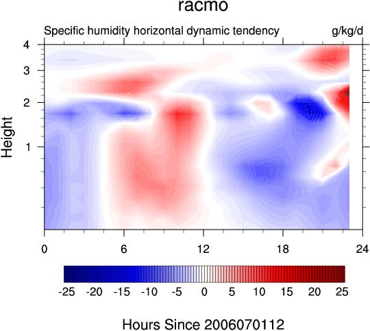
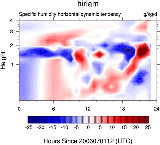
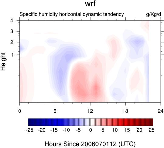
2 Figure 2 Horizontal dynamical tendencies of temperature. Figure 3. Horizontal dynamical tendencies of specific humidity.


3 Figure 4. Horizontal dynamical tendencies of zonal wind (left panels) and meridional wind (right panels) for three models.
4 hind cast mode. Firstly, RACMO with initialization and lateral boundaries taken from ECMWF analysis. RACMO employs HIRLAM dynamics and ECMWF physics. It is run in 25 km horizontal resolution and 40 levels in the vertical. Secondly, HIRLAM which is also initialised and forced at the lateral boundaries by ECMWF analysis. It is run with 11 km resolution and 40 levels in the vertical. Both these models are hydrostatic. Thirdly, WRF 2.2 with initialization and lateral boundaries from NCEP-NFL analysis. It is run in a nested mode advection terms are taken from the 10 km resolution domain. WRF is a non-hydrostatic model. For RACMO and HIRLAM simulations started at UTC. For WRF a start time of UTC was used to get rid of a deviation due to spin up. Horizontal dynamical tendencies are derived by applying the advective operator to the parameters of interest, here temperature, humidity and momentum. For the semi Lagrangian scheme of RACMO we also estimate the tendencies directly from the calculation of the dynamical equations. We have found the same results for the two methods. The passage of a clear air disturbance during the simulated night is well illustrated in figure 1 which shows the geostrophic wind speed and direction. The geostrophic wind speed starts to increase at noon of the second day (which is after the case period), but the geostrophic wind directions shows a marked deviation during the night. Figure 2 shows horizontal dynamic tendencies the temperature for the three models. A distinct warm advection is observed in RACMO and HIRLAM, which reaches the surface at midnight. HIRLAM gives a stronger signal then RACMO. WRF however does not show this feature. Horizontal dynamical tendencies of specific humidity are displayed in figure 3. All three models show moisture advection during the first half of the night in the lowest part of the atmosphere. Details around midnight are different, with HIRLAM giving more small scale structures. Figure 4 shows horizontal dynamic tendencies of the zonal and meridional wind. As for temperature, RACMO and HIRLAM show the same features although the details and strength differ again. WRF shows only a weak signal. 3. LOCAL OBSERVATIONS Observed tendencies at one location are typically the sum of physical and dynamical tendencies. Deriving information on advective tendencies from local observations is only possible when we have detailed information on the physical tendencies. In general this information is not available. However, during stable conditions the air layer above the turbulent stable boundary layer becomes decoupled from the surface making the physical tendencies in the vertical column relatively small. Here we use this feature to qualitatively assess whether the advective tendencies from the models are actually observed at Cabauw. For this we observations at the 200 m level which for this night is well above the turbulent boundary layer. We use a simple model in which the 200 m wind, temperature and specific humidity are initialized by the observed values at sunset and then integrated forward in time with the advective tendencies of RACMO for this height. For momentum the geostrophic wind and the Coriolis acceleration is taken into account. Geostrophic wind is taken from the network of automatic weather station in the Netherlands. We also applied this simple model with advective tendencies as they are, in the end, prescribed for the GABLS3 SCM case. For wind we also applied the model with no advection. Figure 5 shows the observed and modelled temperature. A significant cooling is observed probably due to turbulent transport towards the surface and radiative cooling. A small wiggle is observed with an amplitude of 1 K which is also observed in the RACMO run. A piece wise linear approximation of the racmo dynamical tendency is used for the case description. Figure 6 shows the specific humidity. A well defined deviation with amplitude of 1 g/kg is observed around midnight, which is reasonable represented by RACMO. The case is described with a bit larger amplitude in dynamical tendency. Figure 7 shows a hodogram of the wind together with the observed geostrophic wind. Also shown is a model integration with RACMO advection and with no advection. Here we see that the effect of advection of momentum is quite complex due to interaction with the Coriolis force and the changing geostrophic wind. RACMO advection is not able to give a good representation of the observed 200 m wind. The dynamic tendency of the case is found by trial and error with this simple advective model.
5 Figure 5. Temperature evolution at 200 m. Observations and when RACMO and CASE advection is applied on sunset temperature. Figure 8. Zonal (U) and meridional (V) dynamical wind tendencies of RACMO and as described for the case. Figure 8 shows zonal and meridional dynamical tendencies of RACMO and of the case. Especially the meridional component differ substantially. 4. DISCUSSION AND CONCLUSIONS Figure 6. Specific humidity evolution at 200 m. Observations and when RACMO and CASE advection is applied on sunset temperature. Comparing advective tendencies from 3D models shows that two of them (RACMO and HIRLAM) give comparable results although details and magnitudes may differ. The third model (WRF) shows much weaker tendencies. This might be explained by the longer integration time needed to avoid spin-up problems in this model resulting in a less good forecast or diffusion of sharp transitions in the horizontal fields. No significant differences in advective tendencies have been found when comparing two versions of the same model (HIRLAM) with differing physical parameterizations, not shown here. This suggests that advective model tendencies for clear sky stable boundary layer conditions represent real world conditions. For more complex situations with for example clouds the dependency of dynamical tendencies on the actual parameterization might be much larger. Figure 7. Horizontal wind evolution at 200 m. Observations and when RACMO and CASE advection is applied on sunset wind vector. Also shown is evolution when no advection is applied and shown is the geostrophic wind evolution. B indicates begin of time series (sunset) and E indicates end of time series (11 hours later). Timestep is 10 minutes. By using local observation at heights where the atmospheric flow is decoupled from the surface we have been able to assess the influence of advective tendencies on wind, temperature and specific humidity and to compare these estimates from observations with model output. From this comparison the advective tendencies have been derived that are prescribed in the GABLS3 SCM intercomparison and evaluation case. For more information on this case see
6 5. REFERENCES Baas, P., F.C. Bosveld, and G.-J. Steeneveld (2008). GABLS 3 rd case Cabauw case selection and description. 18 th Symposium on Boundary Layer and Turbulence, 9-13 th June 2008, Stockholm, Sweden. American Meteorological Society (8A.4). Bergot, T. and D. Guedahlia, 1994: Numerical Forecasting of Radiation Fog: Part I: Numerical Model and Sensitivity Tests, Mon. Wea. Rev., 122, Bosveld, F.C., E. van Meijgaard, E. Moors, and C. Werner (2004). Interpretation of eddycorrelation flux observations at different levels along the Cabauw 200 m meteorological mast. 16th AMS symposium on Boundary Layer and Turbulence, 9-13th Aug 2004, 2004, Portland (ME), USA, American Meteorological Society. Bosveld, F.C., E.I.F. de Bruijn and A.M.M. Holtslag (2008). Intercomparison of Single-Column Models for GABLS3: Preliminary results. 18 th Symposium on Boundary Layer and Turbulence, 9-13 th June 2008, Stockholm, Sweden. American Meteorological Society (8A.5). Neggers R. (2008). The KNMI Parameterization Testbed: Motivation, Configuration and Preliminary results 18 th Symposium on Boundary Layer and Turbulence, 9-13 th June 2008, Stockholm, Sweden. American Meteorological Society (8A.7) Teixeira, J. and P.M.A. Miranda, 2001: Fog prediction at Lisbon Airport using a onedimensional boundary layer model, Meteorol. Appl., 8,
The Third GABLS Intercomparison Case for Evaluation Studies of Boundary-Layer Models. Part A: Case Selection and Set-Up
 Boundary-Layer Meteorol DOI 10.1007/s10546-014-9917-3 ARTICLE The Third GABLS Intercomparison Case for Evaluation Studies of Boundary-Layer Models. Part A: Case Selection and Set-Up Fred C. Bosveld Peter
GEWEX Atmospheric Boundary Layer Model
 GEWEX Atmospheric Boundary Layer Model Inter-comparison Studies Timo Vihma 1, Tiina Kilpeläinen 1, Albert A.M. Holtslag 2, Laura Rontu 1, Phil Anderson 3, Klara Finkele 4, and Gunilla Svensson 5 1 Finnish
Stable Atmospheric Boundary Layers and Diurnal Cycles
 Stable Atmospheric Boundary Layers and Diurnal Cycles Introduction and overview of GABLS Bert Holtslag DICE and GABLS4 Workshop, Toulouse, May 20, 2015 Meteorology and Air Quality Department Modeling Atmospheric
Towards the Fourth GEWEX Atmospheric Boundary Layer Model Inter-Comparison Study (GABLS4)
") Towards the Fourth GEWEX Atmospheric Boundary Layer Model Inter-Comparison Study (GABLS4) Timo Vihma 1, Tiina Nygård 1, Albert A.M. Holtslag 2, Laura Rontu 1, Phil Anderson 3, Klara Finkele 4, and Gunilla
Towards the Fourth GEWEX Atmospheric Boundary Layer Model Inter-Comparison Study (GABLS4) Timo Vihma 1, Tiina Nygård 1, Albert A.M. Holtslag 2, Laura Rontu 1, Phil Anderson 3, Klara Finkele 4, and Gunilla
Overview of 10 years of GABLS
 Overview of 10 years of GABLS Bert Holtslag (Wageningen Univ, www.maq.wur.nl ) Thanks to Sukanta Basu (NC State Univ), Bob Beare (Exeter Univ), Fred Bosveld (KNMI), Joan Cuxart (Univ. Balearic Islands)
Atmospheric Boundary Layers:
 Atmospheric Boundary Layers: An introduction and model intercomparisons Bert Holtslag Lecture for Summer school on Land-Atmosphere Interactions, Valsavarenche, Valle d'aosta (Italy), 22 June, 2015 Meteorology
Overview of the GEWEX Atmospheric Boundary Layer Study (GABLS)
") Overview of the GEWEX Atmospheric Boundary Layer Study (GABLS) A.A.M. Holtslag 1, G. Svensson 2, S. Basu 3, B. Beare 4, F.C. Bosveld 5, J. Cuxart 6 1 Meteorology and Air Quality Section, Wageningen University,
Overview of the GEWEX Atmospheric Boundary Layer Study (GABLS) A.A.M. Holtslag 1, G. Svensson 2, S. Basu 3, B. Beare 4, F.C. Bosveld 5, J. Cuxart 6 1 Meteorology and Air Quality Section, Wageningen University,
Research on Fog and Low Clouds at Météo-France / CNRM
 Research on Fog and Low Clouds at Météo-France / CNRM 1) Improved site-specific numerical prediction COBEL-ISBA 1D numerical model CdG field experiment Operational forecast at Paris CdG international airport
2 1-D Experiments, near surface output
 Tuning CBR A.B.C. Tijm 1 Introduction The pre 6.2 reference Hirlam versions have a positive bias in the wind direction under stable conditions (night and winter conditions), accompanied by too strong near
Atmospheric Boundary Layers
 Lecture for International Summer School on the Atmospheric Boundary Layer, Les Houches, France, June 17, 2008 Atmospheric Boundary Layers Bert Holtslag Introducing the latest developments in theoretical
2. Synoptic situation. 3. 3D model set-up and results
 5th International Conference on Fog, Fog Collection and Dew Münster, Germany, 25 30 July 2010 FOGDEW2010-70 c Author(s) 2010 Modeling and Forecasting the Onset and Duration of a Fog Event during Frost
Fog prediction at Lisbon Airport using a one-dimensional boundary layer model
 Fog prediction at Lisbon Airport using a one-dimensional boundary layer model Meteorol. Appl. 8, 497 505 (2001) João Teixeira 1 and Pedro M A Miranda, Centro de Geofisica and Department of Physics, University
GABLS3-LES Intercomparison Study
 GABLS3-LES Intercomparison Study S. Basu 1, A.A.M. Holtslag 2, F.C. Bosveld 3 1 Dept of Marine, Earth, and Atmospheric Sciences, North Carolina State University, USA; 2 Meteorology and Air Quality Section,
2.1 Temporal evolution
 15B.3 ROLE OF NOCTURNAL TURBULENCE AND ADVECTION IN THE FORMATION OF SHALLOW CUMULUS Jordi Vilà-Guerau de Arellano Meteorology and Air Quality Section, Wageningen University, The Netherlands 1. MOTIVATION
Testing and Improving Pacific NW PBL forecasts
 Testing and Improving Pacific NW PBL forecasts Chris Bretherton and Matt Wyant University of Washington Eric Grimit 3Tier NASA MODIS Image Testing and Improving Pacific NW PBL forecasts PBL-related forecast
Modeling and Forecasting the Onset and Duration of Severe Radiation Fog under Frost Conditions
 NOVEMBER 2010 V A N D E R V E L D E E T A L. 4237 Modeling and Forecasting the Onset and Duration of Severe Radiation Fog under Frost Conditions I. R. VAN DER VELDE AND G. J. STEENEVELD Meteorology and
Results of the GABLS3 diurnal-cycle benchmark for wind energy applications
 Results of the GABLS3 diurnal-cycle benchmark for wind energy applications Javier Sanz Rodrigo Wake Conference 2017 Visby, 1 June 2017 GABLS 3: Boundary-layer characteristics (Bosveld et al., 2014) Cabauw
The set-up of a RICO shallow cumulus case for LES
 The set-up of a RICO shallow cumulus case for LES An internship at the: Royal Netherlands Meteorological Institute (KNMI) Louise Nuijens July 23, 2006 2 The set-up of a RICO shallow cumulus case for LES
From Near-Neutral to Strongly Stratified: Adequately Modelling the Clear-Sky Nocturnal Boundary Layer at Cabauw
 Boundary-Layer Meteorol (2018) 166:217 238 https://doi.org/10.1007/s10546-017-0304-8 RESEARCH ARTICLE From Near-Neutral to Strongly Stratified: Adequately Modelling the Clear-Sky Nocturnal Boundary Layer
SPECIAL PROJECT PROGRESS REPORT
 SPECIAL PROJECT PROGRESS REPORT Progress Reports should be 2 to 10 pages in length, depending on importance of the project. All the following mandatory information needs to be provided. Reporting year
The collapse of turbulence in the evening
 The collapse of turbulence in the evening B.J.H. Van de Wiel 1, A. F. Moene 2, H.J.J. Jonker 3, P. Baas 4, S. Basu 5, J. Sun 6, and A.A.M. Holtslag 2 1 Fluid Dynamics Lab., Eindhoven, Technical University,
Turbulent Scales in the Boundary Layer: A Year-Long Large-Eddy Simulation Jerôme Schalkwijk, Harm Jonker, Pier Siebesma
 Turbulent Scales in the Boundary Layer: A Year-Long Large-Eddy Simulation Jerôme Schalkwijk, Harm Jonker, Pier Siebesma Delft University of 16-6-2014 Technology YOGA: A Year-Long Large-Eddy Simulation
Arctic Boundary Layer
 Annual Seminar 2015 Physical processes in present and future large-scale models Arctic Boundary Layer Gunilla Svensson Department of Meteorology and Bolin Centre for Climate Research Stockholm University,
AVIATION APPLICATIONS OF A NEW GENERATION OF MESOSCALE NUMERICAL WEATHER PREDICTION SYSTEM OF THE HONG KONG OBSERVATORY
 P452 AVIATION APPLICATIONS OF A NEW GENERATION OF MESOSCALE NUMERICAL WEATHER PREDICTION SYSTEM OF THE HONG KONG OBSERVATORY Wai-Kin WONG *1, P.W. Chan 1 and Ivan C.K. Ng 2 1 Hong Kong Observatory, Hong
A wind energy benchmark for ABL modelling of a diurnal cycle with a nocturnal low-level jet: GABLS3 revisited
 Journal of Physics: Conference Series PAPER OPEN ACCESS A wind energy benchmark for ABL modelling of a diurnal cycle with a nocturnal low-level jet: GABLS3 revisited To cite this article: J. Sanz Rodrigo
Application and verification of ECMWF products 2016
 Application and verification of ECMWF products 2016 RHMS of Serbia 1 Summary of major highlights ECMWF forecast products became the backbone in operational work during last several years. Starting from
NWP Equations (Adapted from UCAR/COMET Online Modules)
") NWP Equations (Adapted from UCAR/COMET Online Modules) Certain physical laws of motion and conservation of energy (for example, Newton's Second Law of Motion and the First Law of Thermodynamics) govern
NWP Equations (Adapted from UCAR/COMET Online Modules) Certain physical laws of motion and conservation of energy (for example, Newton's Second Law of Motion and the First Law of Thermodynamics) govern
MARINE BOUNDARY-LAYER HEIGHT ESTIMATED FROM NWP MODEL OUTPUT BULGARIA
 MARINE BOUNDARY-LAYER HEIGHT ESTIMATED FROM NWP MODEL OUTPUT Sven-Erik Gryning 1 and Ekaterina Batchvarova 1, 1 Wind Energy Department, Risø National Laboratory, DK-4 Roskilde, DENMARK National Institute
Assessing the impact of observations on a local numerical fog prediction system
 QUARTERLY JOURNAL OF THE ROYAL METEOROLOGICAL SOCIETY Q. J. R. Meteorol. Soc. 135: 1248 1265 (2009) Published online 18 June 2009 in Wiley InterScience (www.interscience.wiley.com).448 Assessing the impact
Validation of 2-meters temperature forecast at cold observed conditions by different NWP models
 Validation of 2-meters temperature forecast at cold observed conditions by different NWP models Evgeny Atlaskin Finnish Meteorological Institute / Russian State Hydrometeorological University OUTLINE Background
CHAPTER 8 NUMERICAL SIMULATIONS OF THE ITCZ OVER THE INDIAN OCEAN AND INDONESIA DURING A NORMAL YEAR AND DURING AN ENSO YEAR
 CHAPTER 8 NUMERICAL SIMULATIONS OF THE ITCZ OVER THE INDIAN OCEAN AND INDONESIA DURING A NORMAL YEAR AND DURING AN ENSO YEAR In this chapter, comparisons between the model-produced and analyzed streamlines,
Figure1. The prescribed (solid line) and observed surface temperature (markers) around the main tower for the entire simulated period.
 and observed surface temperature (markers) around the main tower for the entire simulated period.") 8.1 SINGLE COLUMN MODELING OF THE DIURNAL CYCLE BASED ON CASES99 DATA GABLS SECOND INTERCOMPARISON PROJECT Gunilla Svensson 1* and Albert A. M. Holtslag 2 1 University of Colorado/CIRES, Boulder, CO, USA
8.1 SINGLE COLUMN MODELING OF THE DIURNAL CYCLE BASED ON CASES99 DATA GABLS SECOND INTERCOMPARISON PROJECT Gunilla Svensson 1* and Albert A. M. Holtslag 2 1 University of Colorado/CIRES, Boulder, CO, USA
Project II.2: Fog and Low Clouds: improvement of 1D models
 COST 78- Project II.2 Fog and Low Clouds: Improvement of 1D models 2 Project II.2: Fog and Low Clouds: improvement of 1D models Coordinator: Lars Bergeas (from Feb. 1998) Military Weather Service, Sweden
Weather Research and Forecasting Model. Melissa Goering Glen Sampson ATMO 595E November 18, 2004
 Weather Research and Forecasting Model Melissa Goering Glen Sampson ATMO 595E November 18, 2004 Outline What does WRF model do? WRF Standard Initialization WRF Dynamics Conservation Equations Grid staggering
Description of the ET of Super Typhoon Choi-Wan (2009) based on the YOTC-dataset
 based on the YOTC-dataset") High Impact Weather PANDOWAE Description of the ET of Super Typhoon Choi-Wan (2009) based on the YOTC-dataset ¹, D. Anwender¹, S. C. Jones2, J. Keller2, L. Scheck¹ 2 ¹Karlsruhe Institute of Technology,
High Impact Weather PANDOWAE Description of the ET of Super Typhoon Choi-Wan (2009) based on the YOTC-dataset ¹, D. Anwender¹, S. C. Jones2, J. Keller2, L. Scheck¹ 2 ¹Karlsruhe Institute of Technology,
Addressing Diurnal Temperature Biases in the WRF Model
 Addressing Diurnal Temperature Biases in the WRF Model Jeffrey Massey University of Utah Collaborators: Jim Steenburgh, Jason Knievel, Sebastian Hoch, Josh Hacker Long term 2-m temperature verification
Claus Petersen* and Bent H. Sass* Danish Meteorological Institute Copenhagen, Denmark
 6.8 Improving of road weather forecasting by using high resolution satellite data Claus Petersen* and Bent H. Sass* Danish Meteorological Institute Copenhagen, Denmark. INTRODUCTION Observations of high
Improved Atmospheric Stable Boundary Layer Formulations for Navy Seasonal Forecasting
 DISTRIBUTION STATEMENT A. Approved for public release; distribution is unlimited. Improved Atmospheric Stable Boundary Layer Formulations for Navy Seasonal Forecasting Michael Tjernström Department of
Large-Eddy Simulations of Tropical Convective Systems, the Boundary Layer, and Upper Ocean Coupling
 DISTRIBUTION STATEMENT A. Approved for public release; distribution is unlimited. Large-Eddy Simulations of Tropical Convective Systems, the Boundary Layer, and Upper Ocean Coupling Eric D. Skyllingstad
5. General Circulation Models
 5. General Circulation Models I. 3-D Climate Models (General Circulation Models) To include the full three-dimensional aspect of climate, including the calculation of the dynamical transports, requires
InSAR measurements of volcanic deformation at Etna forward modelling of atmospheric errors for interferogram correction
 InSAR measurements of volcanic deformation at Etna forward modelling of atmospheric errors for interferogram correction Rachel Holley, Geoff Wadge, Min Zhu Environmental Systems Science Centre, University
Swedish Meteorological and Hydrological Institute
 Swedish Meteorological and Hydrological Institute Norrköping, Sweden 1. Summary of highlights HIRLAM at SMHI is run on a CRAY T3E with 272 PEs at the National Supercomputer Centre (NSC) organised together
HARMONIE physics plans Laura Rontu, FMI
 HARMONIE physics plans Laura Rontu, FMI with contributions by Imanol Guerrero, Timo Vihma and others ALARO working days 13-15 June 2012 Ljubljana A FEW STRATEGIC COMMENTS Towards scale-adaptive, cross-package
Egyptian Meteorological Authority Cairo Numerical Weather prediction centre
 JOINT WMO TECHNICAL PROGRESS REPORT ON THE GLOBAL DATA PROCESSING AND FORECASTING SYSTEM AND NUMERICAL WEATHER PREDICTION RESEARCH ACTIVITIES FOR 2016 Egyptian Meteorological Authority Cairo Numerical
Royal Netherlands Meteorological Institute Ministry of Infrastructure and the Environment
 Royal Netherlands Meteorological Institute Ministry of Infrastructure and the Environment 3D Exploration of Weather Data in Combination with IASI L2 Products for Better Understanding of Potential Applications
Predicting low clouds, fog and visbility : experiences and ideas for future strategy
 Predicting low clouds, fog and visbility : experiences and ideas for future strategy OUTLINE: Importance of predicting fog and visibility Processes determining the forecast challenge Brief estimation of
WRF Model Simulated Proxy Datasets Used for GOES-R Research Activities
 WRF Model Simulated Proxy Datasets Used for GOES-R Research Activities Jason Otkin Cooperative Institute for Meteorological Satellite Studies Space Science and Engineering Center University of Wisconsin
An Introduction to Coupled Models of the Atmosphere Ocean System
 An Introduction to Coupled Models of the Atmosphere Ocean System Jonathon S. Wright jswright@tsinghua.edu.cn Atmosphere Ocean Coupling 1. Important to climate on a wide range of time scales Diurnal to
ECMWF global reanalyses: Resources for the wind energy community
 ECMWF global reanalyses: Resources for the wind energy community (and a few myth-busters) Paul Poli European Centre for Medium-range Weather Forecasts (ECMWF) Shinfield Park, RG2 9AX, Reading, UK paul.poli
TC/PR/RB Lecture 3 - Simulation of Random Model Errors
 TC/PR/RB Lecture 3 - Simulation of Random Model Errors Roberto Buizza (buizza@ecmwf.int) European Centre for Medium-Range Weather Forecasts http://www.ecmwf.int Roberto Buizza (buizza@ecmwf.int) 1 ECMWF
Grid point spacing (km) T2047 H K T7999 NH M
 T2047 H K T7999 NH M") (Very) High Res NWP ECMWF High-resolution modelling developments (inputs: Nils Wedi, Mats Hamrud, George Mozdzynski, Jean Bidlot, Geir Austad, Sinisa Curic ) Current and planned resolutions: IFS model
(Very) High Res NWP ECMWF High-resolution modelling developments (inputs: Nils Wedi, Mats Hamrud, George Mozdzynski, Jean Bidlot, Geir Austad, Sinisa Curic ) Current and planned resolutions: IFS model
Weather Forecasting Models in Met Éireann. Eoin Whelan UCD Seminar 3 rd April 2012
 Weather Forecasting Models in Met Éireann Eoin Whelan UCD Seminar 3 rd April 2012 Overview Background HIRLAM Models Local Implementation Verification Development work Background Met Éireann Dept of the
Challenges in model development
 Challenges in model development Andy Brown 29/6/10 Contents How do we try to improve a model? Bottom up Top down Examples (Sensitivity to drag) Bottom up Develop new (and hopefully improved) parametrization
An Intercomparison of Single-Column Model Simulations of Summertime Midlatitude Continental Convection
 An Intercomparison of Single-Column Model Simulations of Summertime Midlatitude Continental Convection S. J. Ghan Pacific Northwest National Laboratory Richland, Washington D. A. Randall, K.-M. Xu, and
Incorporation of 3D Shortwave Radiative Effects within the Weather Research and Forecasting Model
 Incorporation of 3D Shortwave Radiative Effects within the Weather Research and Forecasting Model W. O Hirok and P. Ricchiazzi Institute for Computational Earth System Science University of California
INVESTIGATION FOR A POSSIBLE INFLUENCE OF IOANNINA AND METSOVO LAKES (EPIRUS, NW GREECE), ON PRECIPITATION, DURING THE WARM PERIOD OF THE YEAR
, ON PRECIPITATION, DURING THE WARM PERIOD OF THE YEAR") Proceedings of the 13 th International Conference of Environmental Science and Technology Athens, Greece, 5-7 September 2013 INVESTIGATION FOR A POSSIBLE INFLUENCE OF IOANNINA AND METSOVO LAKES (EPIRUS,
Proceedings of the 13 th International Conference of Environmental Science and Technology Athens, Greece, 5-7 September 2013 INVESTIGATION FOR A POSSIBLE INFLUENCE OF IOANNINA AND METSOVO LAKES (EPIRUS,
MESOSCALE MODELLING OVER AREAS CONTAINING HEAT ISLANDS. Marke Hongisto Finnish Meteorological Institute, P.O.Box 503, Helsinki
 MESOSCALE MODELLING OVER AREAS CONTAINING HEAT ISLANDS Marke Hongisto Finnish Meteorological Institute, P.O.Box 503, 00101 Helsinki INTRODUCTION Urban heat islands have been suspected as being partially
GABLS4: an intercomparison of models in extremely stable conditions over Antarctica
 GABLS4: an intercomparison of models in extremely stable conditions over Antarctica Fleur Couvreux*, E Bazile*, G Canut*, P LeMoigne*, O Traullé*, C Genthon, W Maurel*, E Vignon, and all the participants
Evaluating Parametrizations using CEOP
 Evaluating Parametrizations using CEOP Paul Earnshaw and Sean Milton Met Office, UK Crown copyright 2005 Page 1 Overview Production and use of CEOP data Results SGP Seasonal & Diurnal cycles Other extratopical
TURBULENT KINETIC ENERGY
 TURBULENT KINETIC ENERGY THE CLOSURE PROBLEM Prognostic Moment Equation Number Number of Ea. fg[i Q! Ilial.!.IokoQlI!!ol Ui au. First = at au.'u.' '_J_ ax j 3 6 ui'u/ au.'u.' a u.'u.'u k ' Second ' J =
What you need to know in Ch. 12. Lecture Ch. 12. Atmospheric Heat Engine
 Lecture Ch. 12 Review of simplified climate model Revisiting: Kiehl and Trenberth Overview of atmospheric heat engine Current research on clouds-climate Curry and Webster, Ch. 12 For Wednesday: Read Ch.
Validation of Boundary Layer Winds from WRF Mesoscale Forecasts over Denmark
 Downloaded from orbit.dtu.dk on: Dec 14, 2018 Validation of Boundary Layer Winds from WRF Mesoscale Forecasts over Denmark Hahmann, Andrea N.; Pena Diaz, Alfredo Published in: EWEC 2010 Proceedings online
Development of Yin-Yang Grid Global Model Using a New Dynamical Core ASUCA.
 Development of Yin-Yang Grid Global Model Using a New Dynamical Core ASUCA. M. Sakamoto, J. Ishida, K. Kawano, K. Matsubayashi, K. Aranami, T. Hara, H. Kusabiraki, C. Muroi, Y. Kitamura Japan Meteorological
ECMWF Overview. The European Centre for Medium-Range Weather Forecasts is an international. organisation supported by 23 European States.
 ECMWF Overview The European Centre for Medium-Range Weather Forecasts is an international organisation supported by 3 European States. The center was established in 1973 by a Convention and the real-time
Wind Flow Modeling The Basis for Resource Assessment and Wind Power Forecasting
 Wind Flow Modeling The Basis for Resource Assessment and Wind Power Forecasting Detlev Heinemann ForWind Center for Wind Energy Research Energy Meteorology Unit, Oldenburg University Contents Model Physics
2. Outline of the MRI-EPS
 2. Outline of the MRI-EPS The MRI-EPS includes BGM cycle system running on the MRI supercomputer system, which is developed by using the operational one-month forecasting system by the Climate Prediction
A closer look at fog, clouds in cold conditions and precipitation in HARMONIE-AROME
 A closer look at fog, clouds in cold conditions and precipitation in HARMONIE-AROME A joint presentation by: Lisa Bengtsson, Karl-Ivar Ivarsson, Daniel Martin, Javier Calvo, Gema Morales, Wim de Rooy,
Evaluation of Limited-Area Models for the Representation of the Diurnal Cycle and Contrasting Nights in CASES-99
 MARCH 2008 S T E ENEVELD ET AL. 869 Evaluation of Limited-Area Models for the Representation of the Diurnal Cycle and Contrasting Nights in CASES-99 G. J. STEENEVELD, T. MAURITSEN, E. I. F. DE BRUIJN,
Lecture 12. The diurnal cycle and the nocturnal BL
 Lecture 12. The diurnal cycle and the nocturnal BL Over flat land, under clear skies and with weak thermal advection, the atmospheric boundary layer undergoes a pronounced diurnal cycle. A schematic and
Seasonal dependence of the urban heat island on the street canyon aspect ratio
 QuarterlyJournalof theroyalmeteorologicalsociety Q. J. R. Meteorol. Soc. 140: 2197 2210, October 2014 A DOI:10.1002/qj.2289 Seasonal dependence of the urban heat island on the street canyon aspect ratio
way and atmospheric models
 Scale-consistent consistent two-way way coupling of land-surface and atmospheric models COSMO-User-Seminar 9-11 March 2009 Annika Schomburg, Victor Venema, Felix Ament, Clemens Simmer TR / SFB 32 Objective
The difficult art of evaluation clouds and convection representation in GCM s
 The difficult art of evaluation clouds and convection representation in GCM s Motivation Configuration Results Roel Neggers Pier Siebesma thanks to many others at KNMI Evaluation Strategy Large Eddy Simulation
The Total Energy Mass Flux PBL Scheme: Overview and Performance in Shallow-Cloud Cases
 The Total Energy Mass Flux PBL Scheme: Overview and Performance in Shallow-Cloud Cases Wayne M. Angevine CIRES, University of Colorado, and NOAA ESRL Thorsten Mauritsen Max Planck Institute for Meteorology,
Fundamentals of Weather and Climate
 Fundamentals of Weather and Climate ROBIN McILVEEN Environmental Science Division Institute of Environmental and Biological Sciences Lancaster University CHAPMAN & HALL London Glasgow Weinheim New York
4.4 EVALUATION OF AN IMPROVED CONVECTION TRIGGERING MECHANISM IN THE NCAR COMMUNITY ATMOSPHERE MODEL CAM2 UNDER CAPT FRAMEWORK
 . EVALUATION OF AN IMPROVED CONVECTION TRIGGERING MECHANISM IN THE NCAR COMMUNITY ATMOSPHERE MODEL CAM UNDER CAPT FRAMEWORK Shaocheng Xie, James S. Boyle, Richard T. Cederwall, and Gerald L. Potter Atmospheric
Importance of Numerical Weather Prediction in Variable Renewable Energy Forecast
 Importance of Numerical Weather Prediction in Variable Renewable Energy Forecast Dr. Abhijit Basu (Integrated Research & Action for Development) Arideep Halder (Thinkthrough Consulting Pvt. Ltd.) September
MODEL TYPE (Adapted from COMET online NWP modules) 1. Introduction
 1. Introduction") MODEL TYPE (Adapted from COMET online NWP modules) 1. Introduction Grid point and spectral models are based on the same set of primitive equations. However, each type formulates and solves the equations
MODEL TYPE (Adapted from COMET online NWP modules) 1. Introduction Grid point and spectral models are based on the same set of primitive equations. However, each type formulates and solves the equations
Assessing WRF PBL Schemes for Wind Energy Applications
 Assessing WRF PBL Schemes for Wind Energy Applications Branko Kosović, Yubao Liu, Youwei Liu, Will Cheng NCAR Workshop May 12, 21 NATIONAL CENTER FOR ATMOSPHERIC RESEARCH In the Past PBL Parameterizations
Logistics. Goof up P? R? Can you log in? Requests for: Teragrid yes? NCSA no? Anders Colberg Syrowski Curtis Rastogi Yang Chiu
 Logistics Goof up P? R? Can you log in? Teragrid yes? NCSA no? Requests for: Anders Colberg Syrowski Curtis Rastogi Yang Chiu Introduction to Numerical Weather Prediction Thanks: Tom Warner, NCAR A bit
Response and Sensitivity of the Nocturnal Boundary Layer Over Land to Added Longwave Radiative Forcing
 Response and Sensitivity of the Nocturnal Boundary Layer Over Land to Added Longwave Radiative Forcing Richard T. McNider Earth System Science Center, University of Alabama in Huntsville, Huntsville, AL,
Improved Site-Specific Numerical Prediction of Fog and Low Clouds: A Feasibility Study
 AUGUST 2005 B E R G O T E T A L. 627 Improved Site-Specific Numerical Prediction of Fog and Low Clouds: A Feasibility Study THIERRY BERGOT, DOMINIQUE CARRER,* JOËL NOILHAN, AND PHILIPPE BOUGEAULT Centre
The Effect of Sea Spray on Tropical Cyclone Intensity
 The Effect of Sea Spray on Tropical Cyclone Intensity Jeffrey S. Gall, Young Kwon, and William Frank The Pennsylvania State University University Park, Pennsylvania 16802 1. Introduction Under high-wind
Mesoscale meteorological models. Claire L. Vincent, Caroline Draxl and Joakim R. Nielsen
 Mesoscale meteorological models Claire L. Vincent, Caroline Draxl and Joakim R. Nielsen Outline Mesoscale and synoptic scale meteorology Meteorological models Dynamics Parametrizations and interactions
Diurnal cycle Coupling Experiment (DICE) GLASS / GASS joint project. Martin Best and Adrian Lock Crown copyright Met Office
 GLASS / GASS joint project. Martin Best and Adrian Lock Crown copyright Met Office") Diurnal cycle Coupling Experiment (DICE) GLASS / GASS joint project Martin Best and Adrian Lock Courtesy of Mike Ek GLACE hotspot regions Koster et al (2006) Outline of the 3 stages of DICE LSM and SCM
Diurnal cycle Coupling Experiment (DICE) GLASS / GASS joint project Martin Best and Adrian Lock Courtesy of Mike Ek GLACE hotspot regions Koster et al (2006) Outline of the 3 stages of DICE LSM and SCM
M.Sc. in Meteorology. Physical Meteorology Prof Peter Lynch. Mathematical Computation Laboratory Dept. of Maths. Physics, UCD, Belfield.
 M.Sc. in Meteorology Physical Meteorology Prof Peter Lynch Mathematical Computation Laboratory Dept. of Maths. Physics, UCD, Belfield. Climate Change???????????????? Tourists run through a swarm of pink
Lake parameters climatology for cold start runs (lake initialization) in the ECMWF forecast system
 in the ECMWF forecast system") 2nd Workshop on Parameterization of Lakes in Numerical Weather Prediction and Climate Modelling Lake parameters climatology for cold start runs (lake initialization) in the ECMWF forecast system R. Salgado(1),
2nd Workshop on Parameterization of Lakes in Numerical Weather Prediction and Climate Modelling Lake parameters climatology for cold start runs (lake initialization) in the ECMWF forecast system R. Salgado(1),
High resolution regional reanalysis over Ireland using the HARMONIE NWP model
 High resolution regional reanalysis over Ireland using the HARMONIE NWP model Emily Gleeson, Eoin Whelan With thanks to John Hanley, Bing Li, Ray McGrath, Séamus Walsh, Motivation/Inspiration KNMI 5 year
General Circulation. Nili Harnik DEES, Lamont-Doherty Earth Observatory
 General Circulation Nili Harnik DEES, Lamont-Doherty Earth Observatory nili@ldeo.columbia.edu Latitudinal Radiation Imbalance The annual mean, averaged around latitude circles, of the balance between the
Small-scale orographic gravity wave drag in stable boundary layers and its impacts on synoptic systems and near surface meteorology
 Quarterly Journal of the Royal Meteorological Society Q. J. R. Meteorol. Soc. 00: 1 15 (2016) Small-scale orographic gravity wave drag in stable boundary layers and its impacts on synoptic systems and
Shallow cumulus evaluated with the LASSO (ensemble LES) framework
 framework") Shallow cumulus evaluated with the LASSO (ensemble LES) framework Wayne M. Angevine, Joe Olson, and Jaymes Kenyon CIRES, University of Colorado, and NOAA ESRL Outline: What and why is LASSO? The shallow
Shallow cumulus evaluated with the LASSO (ensemble LES) framework Wayne M. Angevine, Joe Olson, and Jaymes Kenyon CIRES, University of Colorado, and NOAA ESRL Outline: What and why is LASSO? The shallow
Regional Climate Simulations with WRF Model
 WDS'3 Proceedings of Contributed Papers, Part III, 8 84, 23. ISBN 978-8-737852-8 MATFYZPRESS Regional Climate Simulations with WRF Model J. Karlický Charles University in Prague, Faculty of Mathematics
The Planetary Boundary Layer and Uncertainty in Lower Boundary Conditions
 The Planetary Boundary Layer and Uncertainty in Lower Boundary Conditions Joshua Hacker National Center for Atmospheric Research hacker@ucar.edu Topics The closure problem and physical parameterizations
NCEP non-hydrostatic regional model and surface scheme LAPS: A dynamical scaling tool for use in agricultural models
 NCEP non-hydrostatic regional model and surface scheme LAPS: A dynamical scaling tool for use in agricultural models D.T. Mihailović and B. Lalić Faculty of Agriculture, University of Novi Sad, Novi Sad,
Radiative contribution to the North-American cold air outbreaks in a Lagrangian perspective
 Radiative contribution to the North-American cold air outbreaks in a Lagrangian perspective Natalia Bliankinshtein, Y. Huang, J. R. Gyakum and E. Atallah Department of Atmospheric and Oceanic Sciences
Screen level temperature increase due to higher atmospheric carbon dioxide in calm and windy nights revisited
 JOURNAL OF GEOPHYSICAL RESEARCH, VOL. 116,, doi:10.1029/2010jd014612, 2011 Screen level temperature increase due to higher atmospheric carbon dioxide in calm and windy nights revisited G. J. Steeneveld,
The Atmospheric Boundary Layer. The Surface Energy Balance (9.2)
") The Atmospheric Boundary Layer Turbulence (9.1) The Surface Energy Balance (9.2) Vertical Structure (9.3) Evolution (9.4) Special Effects (9.5) The Boundary Layer in Context (9.6) What processes control
The Atmospheric Boundary Layer Turbulence (9.1) The Surface Energy Balance (9.2) Vertical Structure (9.3) Evolution (9.4) Special Effects (9.5) The Boundary Layer in Context (9.6) What processes control
Department of Meteorology, School of Ocean and Earth Science and Technology, University of Hawaii at Manoa, Honolulu, Hawaii
 478 J O U R N A L O F C L I M A T E VOLUME 0 Horizontal and Vertical Structures of the Northward-Propagating Intraseasonal Oscillation in the South Asian Monsoon Region Simulated by an Intermediate Model*
Cold air outbreak over the Kuroshio Extension Region
 Cold air outbreak over the Kuroshio Extension Region Jensen, T. G. 1, T. Campbell 1, T. A. Smith 1, R. J. Small 2 and R. Allard 1 1 Naval Research Laboratory, 2 Jacobs Engineering NRL, Code 7320, Stennis
Coupling between clouds and their environment: using observations to constrain models
 Coupling between clouds and their environment: using observations to constrain models Louise Nuijens ECMWF Annual Seminar 2015 Brian Medeiros, Irina Sandu and Maike Alhgrimm Photograph: Frederic Batier
Parametrizing Cloud Cover in Large-scale Models
 Parametrizing Cloud Cover in Large-scale Models Stephen A. Klein Lawrence Livermore National Laboratory Ming Zhao Princeton University Robert Pincus Earth System Research Laboratory November 14, 006 European