Geographic Information System
|
|
|
- Willa Cameron
- 6 years ago
- Views:
Transcription


1 GEOG4340 Q. Cheng Geographic Information System Lecture Nine Data Integration Spatial Decision Support System (SDSS) Mapping areas for drilling in mining industry Multivariate Logistic Regression


 Geophysical Geochemical.")
2 3D Simulation and Decision Making Various Types of Data Integration Combining multi-layers layers of geoinformation for decision making Multi-sources Multi-scales Multi-formats Multi-owners Multi-temporal temporal captures Spatial Decision Support System Multiple Map Modeling Decision Theory is concerned with the logic by which one arrives at a choice between alternatives. Alternative Actions Alternative hypotheses Alternative objects so on Potential Applications Site Selection Suitability Assessment Favorability Assessment Probability Assessment Spatial Decision Support System (SDSS) GIS Data Integration for Prediction Suitability Map for Planning School GIS Data Sources DMS DMS DMS DMS Data Preprocessing Interpreting Information Extraction Processing Evidential Layers (X) Geophysical Geochemical.. Geographical Geological Remote Sensing Modeling (F) Integration Output Data (S) Potential 2


3 A General Spatial Modeling Processes Stating the problem reaking the problem down Exploring input datasets Determining analysis processes Verifying the model s result Implementing the result and reporting 3
4 Model of Processes for finding Distance from rec. facilities Model of Processes for finding Distance beyond existing schools Recreational Site uffer Rec. Site uffer Schools uffer School uffer Reclassify Distance to Rec. Site Reclassify Distance to School Model of Processes for finding Relative flat area Model of Processes for finding Suitable landuse type Elevation Slope Slope Map Landuse Map Reclassify Landuse Classes Reclassify Slope Classes Model Constraints Normalization:. Convert maps into comparable unit x i =, 2,..., 0, yes, present, suitable x i = 0, no, absent, notsuitable Model of Processes for combining Diverse maps Landuse Slope 2. Assigning weights for each map as % Dist. Rec. Site Calculator Suitability Map w + w 0 w i w n = Dist. School 4
5 Combine Maps Grid calculator with equation S = 0.50 rec_site dist_school rec_landuse rec_slope Map S has values between -0 Model Validation Are the criteria reasonable? Is the model valid? Does the result meet the requirement? Are there errors related to the result? Are all data used necessary? General Data Integration Model for SDSS S = F(x, x 2,, x n ) S Index map showing Suitability Probability x i - maps or evidences w i - weights Simple Linear Model S = w x + w2x w n x n S Index map showing Suitability Probability x i - maps or evidences w i - weights Model Constraints Normalization:. Convert maps into comparable unit, yes, yes x i = x i = 0.5, unknown x i =,2,..., 0 0, no 0, no 2. Weights showing relative importance of maps w + w w = 0 w i 2 n 5

6 Methods for Calculating Weights for Data Integration Data Driven Methods: Weights of evidence Logistic regression Artificial Neural network Knowledge driven Methods: Fuzzy logic Hybrid Methods: Fuzzy weights of evidence Model Types. Probabilistic S random variable showing probability 0 S with uncertainty 2. Deterministic S Score 0 S Relationships etween Different Models Spatial Data Modeler Extension: Arc-SDM Simple Overlay Model (Union, Intersect, Identity) Linear Model (adding weights) Logistic Model (Weights of Evidence, Logistic Regression) Fuzzy Logic model (various operators) Weights of Evidence Logistic Regression Fuzzy Logic Neural Network 6
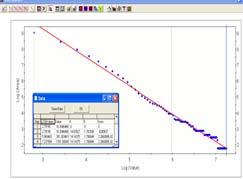
 Concept of Prior probability and Posterior probability 0.57 not A 0.06 0.")
 Posterior probability: number of point /pattern area (density of point/area) - P(D A) Percentage of points: # points on pattern/total # of")
7 A A not not A not A not A not A not A ID Area PolyA A A nota nota Poly not not Points points/area Prior probability total number of point / total area 0/00 = 0.0 (0%) Concept of Prior probability and Posterior probability 0.57 not A not A not 0.5 A not Prior probability: total number of point / total area 0/00 = 0.0 (0%) Posterior probability: number of point /pattern area (density of point/area) - P(D A) Percentage of points: # points on pattern/total # of points P(A D) Posterior probability: number of point /pattern area 4
8 Three patterns: trees, lake and road buffer 0.(0.2) not A not A C A not notc A not C nota not notc not A not C A 0.4(0.42) 0.2(0.8) A not not A C nota notc A notc 0.3 P ( A (0.28) D) = 0.5 not A Percentage of points not A 0.4 (0.42) 0.2 (0.8) 0.6 not A 0.3 (0.28) 0. (0.2) Percentage of points not A 0.4 (0.42) P(A D) 0.2 (0.8) P(A not D) 0.6 P(A D) not A 0.3 (0.28) P(notA D) 0. (0.2) P( D) 0.3 P(not D) P(notA not D) P(notA D) Joint probability marginal probability Percentage of points of independent events Percentage of points on A = % points on A * % points on P(A D) = P(A D) P( D) Joint probability marginal probability 5
9 A 0.07(0.0) not A 0.3 P ( A (0.0) D) = (0.42) A not Percentage of Areas 0.35(0.38) not A not not A 0.07 (0.0) 0.45 (0.42) 0.52 not A 0.3 (0.0) 0.35 (0.38) Percentage of areas not A 0.07 (0.0) 0.45 (0.42) 0.52 not A 0.3 (0.0) P(A) P(notA ) P(A not) P(A) 0.35 (0.38) P(notA not) 0.48 P(notA) Joint probability P() P(not) marginal probability Percentage of areas of independent events % Area of A = % Area of A * % Area of Joint probability P(A) = P(A) P() marginal probability ayes s Rule: Probability map P(D A) = P(D)P(A D)/P(A) P(D nota) = P(D)P(notA D)/P(notD) P(D A) = P(D) P(A D)/P(A) P( D)/P() P(D Anot) = P(D)P(A D)/P(A) P(not D)/P(not) P(D not A) = P(D)P(notA D)/P(notA) P( D)/P() P(D not A not) = P(D)P(notA D)/P(notA) P(not D)/P(not ) 6
10 ayes s Rule: If A,, C are conditionally independent then Log (Probability) log[p(d A)] = log[p(d)]+log[p(a D)/P(A)] = Log[P(D)] + W + A Log[P(D nota)] = log[p(d)] + log[p(nota D)/P(notD)] = Log[P(D)] + W - A Where W A+ = log[p(a D)/P(A)] W A- = log[p(nota D)/P(notA)] Log[P(D A)] = log[p(d)] +W A+ + W + Log[P(D A not)] = log[p(d)] +W A+ + W - Log[P(D nota)] = log[p(d)] +W A- + W + Log[P(D nota not )] = log[p(d)] +W A- + W - P(A D) W A+ = log[p(a D)/P(A)] = Log[ ] P(A) % points on A = Log[ ] % Area of A W + A > 0 positive correlation between A and points W + A = 0 no correlation between A and points W + A < 0 negative correlation between A and points Spatial Association Index Contrast C = W A+ -W - A () - < C < (2) C = 0 A and D are independent (3) C > 0 positive correlation between D and A (4) C < 0 negative correlation between D and A 7
 P(")
 Prior")


 = 7780")
")
 = 0.")
11 Logistic Model for SDSS P(D) P( D A), P( D ) P( D A...) Prior Probability Posterior Probability Logit{ D A...} W0 + W A + W +... = #(D) =20 Area(T) = 7780 P(D) = Area(A) =3065 #(D A) = 5 P(D A) = Area() =475 #(D ) = 9 P(D ) =

")

12 Area(A) = #(D A) = 3 P(D A) =


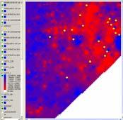
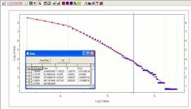
13 Au, W, As, Au- Sn- W- As Multiple Elements Spatial Data Modeler Extension: Arc-SDM Weights of Evidence Logistic Regression Fuzzy Logic Neural Network 9
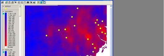
 Prediction of Potential Flowing Wells in the ORM Logit{ D A.")


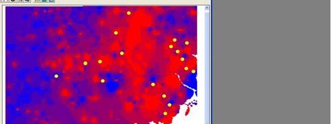
14 Logistic Model for SDSS Posterior Probability P( D A...) Prediction of Potential Flowing Wells in the ORM Logit{ D A...} W0 + W A + W +... = Flowing Wells and Springs Flowing Wells vs. Distance from ORM Spatial Correlation Distance Flowing Wells vs. Distance from ORM Flowing Wells vs. Distance From High Slope Zone Spatial Correlation Spatial Correlation Distance Distance 0


 of thick drift area 6.2 29.3 0.79 6.56 0.45 0.3 Elevation of the upper confined aqu ifers at 356~375 (m a. s. l.) 6.8 38.6.8 0.440.")
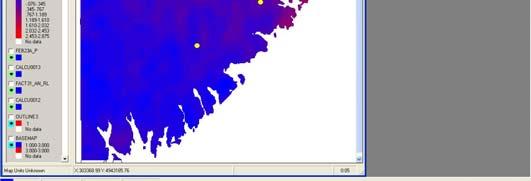
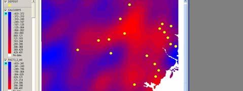
15 Flowing Wells vs. Thickness of Drift Flowing vs. Distance from Thick Drift 8 Spatial Correlation Distance Flowing vs. Distance from Thick Drift Potential Locations of Flowing Wells by SDSS Weights of Evidence (Cheng, 200) Results obtained by Weights of Evidence and Logistic Regression Methods Theme Area t- LR LR Points% Contrast % value Coeff. Std uffer zone (~km) around steep slope uffer zone (~5km) around the ORM uffer zone around steep slope of lower sand / gravel top Ratio of sand/gravel unit cumulative thickness in well depth (6~25%) uffer zone (~2.5km) of thick drift area Elevation of the upper confined aqu ifers at 356~375 (m a. s. l.) Elevation of the lower confined aquifers at 3~347 (m a. s. l.) Steep slope of confined aquifer surface uffer zone ( 0~2km) around the small ponds Intercept constant
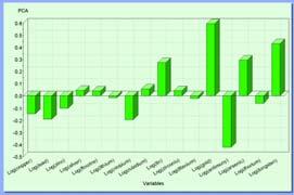
16 Multivariate Logistic Regression 2
Hybrid Fuzzy Weights-of-Evidence Model
 Chapter 5 Hybrid Fuzzy Weights-of-Evidence Model This chapter is based on a paper titled A Hybrid Fuzzy Weights of Evidence Model for Mineral Potential Mapping (Porwal et al., 2006c). The model combines
Spatial Analysis. Reading materials. Vector-Based Spatial Analysis: Model Modeling processes ArcGIS Modelbuilder
 EATS4400.03 Geographic Information Systems and Data Integration Lecture Three 2011 winter Vector-Based Spatial Analysis: Model Modeling processes ArcGIS Modelbuilder Cheng. Q., Earth and Space Science
Application of Weights of Evidence Method for Assessment of Flowing Wells in the Greater Toronto Area, Canada
 Natural Resources Research, Vol. 13, No. 2, June 2004 ( C 2004) Application of Weights of Evidence Method for Assessment of Flowing Wells in the Greater Toronto Area, Canada Qiuming Cheng 1,2 Received
New version of the Spatial Data Modeler tool: ArcSDM 5. ArcSDM 5 Final Seminar May 4 th 2018, Rovaniemi
 New version of the Spatial Data Modeler tool: ArcSDM 5 ArcSDM 5 Final Seminar May 4 th 2018, Rovaniemi Funding 2 Acknowledgements This presentation may include slides borrowed from the following persons
In classical set theory, founded
 Fuzzy logic: Identifying areas for mineral development by Mandy Vickers and Gavin Fleming, Mintek This article looks at the application of fuzzy logic set theory in GIS to identify potential areas for
Hendra Pachri, Yasuhiro Mitani, Hiro Ikemi, and Ryunosuke Nakanishi
 21 2nd International Conference on Geological and Civil Engineering IPCBEE vol. 8 (21) (21) IACSIT Press, Singapore DOI: 1.7763/IPCBEE. 21. V8. 2 Relationships between Morphology Aspect and Slope Failure
EE562 ARTIFICIAL INTELLIGENCE FOR ENGINEERS
 EE562 ARTIFICIAL INTELLIGENCE FOR ENGINEERS Lecture 16, 6/1/2005 University of Washington, Department of Electrical Engineering Spring 2005 Instructor: Professor Jeff A. Bilmes Uncertainty & Bayesian Networks
Spatio-temporal models
 Spatio-temporal models Involve a least a three dimensional representation of one or more key attribute variation in planar (X-Y) space and through time. (a 4 th dimension could also be use, like Z for
A predictive GIS methodology for mapping potential mining induced rock falls
 University of Wollongong Thesis Collections University of Wollongong Thesis Collection University of Wollongong Year 006 A predictive GIS methodology for mapping potential mining induced rock falls Hani
Dr.Weerakaset Suanpaga (D.Eng RS&GIS)
") The Analysis of Discrete Entities i in Space Dr.Weerakaset Suanpaga (D.Eng RS&GIS) Aim of GIS? To create spatial and non-spatial database? Not just this, but also To facilitate query, retrieval and analysis
The Analysis of Discrete Entities i in Space Dr.Weerakaset Suanpaga (D.Eng RS&GIS) Aim of GIS? To create spatial and non-spatial database? Not just this, but also To facilitate query, retrieval and analysis
Spatial modelling of phosphorite deposits in the Irece Basin, Bahia, Brazil. W. Franca-Rocha 1,2, A. Misi 2
 Spatial modelling of phosphorite deposits in the Irece Basin, Bahia, Brazil W. Franca-Rocha 1,2, A. Misi 2 1 Universidade Estadual de Feira de Santana,Km 3, Br 116, Feira de Santana, 44431-460, Brazil,
Outline. Geographic Information Analysis & Spatial Data. Spatial Analysis is a Key Term. Lecture #1
 Geographic Information Analysis & Spatial Data Lecture #1 Outline Introduction Spatial Data Types: Objects vs. Fields Scale of Attribute Measures GIS and Spatial Analysis Spatial Analysis is a Key Term
SPATIAL MODELING GIS Analysis Winter 2016
 SPATIAL MODELING GIS Analysis Winter 2016 Spatial Models Spatial Modeling attempts to represent how the world works All models are wrong, but some are useful (G.E. Box, quoted in course textbook pg. 379)
Basics of GIS. by Basudeb Bhatta. Computer Aided Design Centre Department of Computer Science and Engineering Jadavpur University
 Basics of GIS by Basudeb Bhatta Computer Aided Design Centre Department of Computer Science and Engineering Jadavpur University e-governance Training Programme Conducted by National Institute of Electronics
Lesson 9 and 10: Final Project. by Diana Jo Lau
 Lesson 9 and 10: Final Project by Diana Jo Lau Introduction Acme Conservation Unlimited conducted a site selection analysis of conservation areas meeting specific criteria. The results of our analysis
Using Predictive Modelling to Aid Planning in the Mineral Exploration and Mining Sector A Case Study using the Powelliphanta Land Snail
 Using Predictive Modelling to Aid Planning in the Mineral Exploration and Mining Sector A Case Study using the Powelliphanta Land Snail C. Wildman 1 and K. Peters 2 1 Kenex Limited, PO Box 41136, Eastbourne,
POWELLIPHANTA LAND SNAIL: A PREDICTIVE MODEL FOR IDENTIFYING THE POTENTIAL LOCATION OF POWELLIPHANTA LAND SNAILS IN THE SOUTH ISLAND OF NEW ZEALAND
 POWELLIPHANTA LAND SNAIL: A PREDICTIVE MODEL FOR IDENTIFYING THE POTENTIAL LOCATION OF POWELLIPHANTA LAND SNAILS IN THE SOUTH ISLAND OF NEW ZEALAND Charlene Wildman and Katie Peters Kenex Knowledge Systems,
Machine Learning, Midterm Exam: Spring 2009 SOLUTION
 10-601 Machine Learning, Midterm Exam: Spring 2009 SOLUTION March 4, 2009 Please put your name at the top of the table below. If you need more room to work out your answer to a question, use the back of
Abstract: Contents. Literature review. 2 Methodology.. 2 Applications, results and discussion.. 2 Conclusions 12. Introduction
 Abstract: Landfill is one of the primary methods for municipal solid waste disposal. In order to reduce the environmental damage and to protect the public health and welfare, choosing the site for landfill
Spatial Data Modelling: The Search For Gold In Otago. Presented By Matthew Hill Kenex Knowledge Systems (NZ) Kenex. Kenex
 Kenex. Kenex") Spatial Data Modelling: The Search For Gold In Otago Presented By Matthew Hill Knowledge Systems (NZ) Acknowledgements Michelle Stokes & Greg Partington - Pty Ltd (Australia) Paul Matthews, Charlene Wildman,
Spatial Data Modelling: The Search For Gold In Otago Presented By Matthew Hill Knowledge Systems (NZ) Acknowledgements Michelle Stokes & Greg Partington - Pty Ltd (Australia) Paul Matthews, Charlene Wildman,
Resource Management through Machine Learning
 Resource Management through Machine Learning Justin Granek Eldad Haber* Elliot Holtham University of British Columbia University of British Columbia NEXT Exploration Inc Vancouver, BC V6T 1Z4 Vancouver,
Local Probability Models
 Readings: K&F 3.4, 5.~5.5 Local Probability Models Lecture 3 pr 4, 2 SE 55, Statistical Methods, Spring 2 Instructor: Su-In Lee University of Washington, Seattle Outline Last time onditional parameterization
GIS Spatial Modeling of Landscape and Water Systems in GTA, Canada
 ISPRS SIPT IGU UCI CIG ACSG Table of contents Table des matières Authors index Index des auteurs Search Recherches Exit Sortir GIS Spatial Modeling of Landscape and Water Systems in GTA, Canada Qiuming
A Basic Introduction to Geographic Information Systems (GIS) ~~~~~~~~~~
 ~~~~~~~~~~") A Basic Introduction to Geographic Information Systems (GIS) ~~~~~~~~~~ Rev. Ronald J. Wasowski, C.S.C. Associate Professor of Environmental Science University of Portland Portland, Oregon 3 September
A Basic Introduction to Geographic Information Systems (GIS) ~~~~~~~~~~ Rev. Ronald J. Wasowski, C.S.C. Associate Professor of Environmental Science University of Portland Portland, Oregon 3 September
Introduction to Bayesian Learning. Machine Learning Fall 2018
 Introduction to Bayesian Learning Machine Learning Fall 2018 1 What we have seen so far What does it mean to learn? Mistake-driven learning Learning by counting (and bounding) number of mistakes PAC learnability
Prospectivity Modelling of Granite-Related Nickel Deposits Throughout Eastern Australia
 Prospectivity Modelling of Granite-Related Nickel Deposits Throughout Eastern Australia M P Hill 1 and A McCarthy 2 ABSTRACT Spatial modelling has been used to determine potential locations of granite-related
Raster Analysis: An Example
 Raster Analysis: An Example Fires (1 or 4) Slope (1-4) + Geology (1-4) Erosion Ranking (3-12) 1 Typical Raster Model Types: Suitability Modeling: Where is optimum location? Distance Modeling: What is the
Raster Analysis; A Yellowstone Example 3/29/2018
 Fires (1 or 4) Typical Raster Model Types: Raster Analysis: An Example Suitability Modeling: Where is optimum location? Distance Modeling: What is the most efficient path from A to B? + Slope (1-4) Geology
Raster Analysis; A Yellowstone Example 10/24/2013. M. Helper GEO327G/386G, UT Austin 2. M. Helper GEO327G/386G, UT Austin 4
 + Fires (1 or 4) Slope (1-4) Geology (1-4) Erosion Ranking (3-12) Raster Analysis: An Example Typical Raster Model Types: Suitability Modeling: Where is optimum location? Distance Modeling: What is the
Remote Sensing and Spatial Analysis Applied to Prospectivity Mapping. Carlos R. Souza Filho S. Asadzade T. Lammoglia University of Campinas (UNICAMP)
") Remote Sensing and Spatial Analysis Applied to Prospectivity Mapping Carlos R. Souza Filho S. Asadzade T. Lammoglia University of Campinas (UNICAMP) Lisbon, December 2017 INTRODUCTION The detection of
Remote Sensing and Spatial Analysis Applied to Prospectivity Mapping Carlos R. Souza Filho S. Asadzade T. Lammoglia University of Campinas (UNICAMP) Lisbon, December 2017 INTRODUCTION The detection of
An event described by a single characteristic e.g., A day in January from all days in 2012
 Events Each possible outcome of a variable is an event. Simple event An event described by a single characteristic e.g., A day in January from all days in 2012 Joint event An event described by two or
The Favorability of Florida s Geology to Sinkhole Formation
 Florida Geological Survey The Favorability of Florida s Geology to Sinkhole Formation Clint Kromhout Alan Baker October 24, 2017 Subsidence Report Database Map of Subsidence Incident Reports taken from
EXPLORATION TARGETING USING GIS: MORE THAN A DIGITAL LIGHT TABLE
 EXPLORATION TARGETING USING GIS: MORE THAN A DIGITAL LIGHT TABLE G A PARTINGTON 1 INTRODUCTION The use of computers in mineral exploration in the last twenty years has dramatically changed the way we carry
Raster Analysis: An Example
 Raster Analysis: An Example Fires (1 or 4) Slope (1-4) + Geology (1-4) Erosion Ranking (3-12) 11/8/2016 GEO327G/386G, UT Austin 1 Typical Raster Model Types: Suitability Modeling: Where is optimum location?
Midterm Review CS 6375: Machine Learning. Vibhav Gogate The University of Texas at Dallas
 Midterm Review CS 6375: Machine Learning Vibhav Gogate The University of Texas at Dallas Machine Learning Supervised Learning Unsupervised Learning Reinforcement Learning Parametric Y Continuous Non-parametric
Artificial neural networks as a tool for mineral potential mapping with GIS
 INT. J. REMOTE SENSING, 2003, VOL. 24, NO. 5, 1151 1156 Artificial neural networks as a tool for mineral potential mapping with GIS J. P. RIGOL-SANCHEZ Department of Geology, University of Jaen, 23071,
Species Distribution Modeling
 Species Distribution Modeling Julie Lapidus Scripps College 11 Eli Moss Brown University 11 Objective To characterize the performance of both multiple response and single response machine learning algorithms
Lecture 10: Introduction to reasoning under uncertainty. Uncertainty
 Lecture 10: Introduction to reasoning under uncertainty Introduction to reasoning under uncertainty Review of probability Axioms and inference Conditional probability Probability distributions COMP-424,
THE USE OF GIS IN GEOTHERMAL RESOURCE MANAGEMENT: A CASE STUDY OF OLKARIA GEOTHERMAL PROJECT
 Presented at SDG Short Course II on Exploration and Development of Geothermal Resources, organized by UNU-GTP, GDC and KenGen, at Lake Bogoria and Lake Naivasha, Kenya, Nov. 9-29, 2017. Kenya Electricity
envision Technical Report Archaeological Prediction Maps Kapiti Coast
 envision Technical Report Archaeological Prediction Maps Kapiti Coast Elise Smith September 2012 Contents HYPOTHESIS:... 3 Technical challenges... 3 Alternative methods of analysis considered:... 3 Approach
Improvements on 2D modelling with 3D spatial data: Tin prospectivity of Khartoum, Queensland, Australia
 Improvements on 2D modelling with 3D spatial data: Tin prospectivity of Khartoum, Queensland, Australia C. E. Payne, F. W. Cunningham, A. J. Wilkins & G. A. Partington Kenex Ltd. Outline Prospectivity
Geog 469 GIS Workshop. Data Analysis
 Geog 469 GIS Workshop Data Analysis Outline 1. What kinds of need-to-know questions can be addressed using GIS data analysis? 2. What is a typology of GIS operations? 3. What kinds of operations are useful
LANDSLIDE RISK ASSESSMENT IN YOSEMITE NATIONAL PARK. Edna Rodriguez December 1 st, 2016 Final Project
 LANDSLIDE RISK ASSESSMENT IN YOSEMITE NATIONAL PARK Edna Rodriguez December 1 st, 2016 Final Project Table of Contents Introduction... 2 Data Collection... 2 Data Preprocessing... 3 ArcGIS Processing...
Lecture 9: Bayesian Learning
 Lecture 9: Bayesian Learning Cognitive Systems II - Machine Learning Part II: Special Aspects of Concept Learning Bayes Theorem, MAL / ML hypotheses, Brute-force MAP LEARNING, MDL principle, Bayes Optimal
GIS for ChEs Introduction to Geographic Information Systems
 GIS for ChEs Introduction to Geographic Information Systems AIChE Webinar John Cirucci 1 GIS for ChEs Introduction to Geographic Information Systems What is GIS? Tools and Methods Applications Examples
Midterm Review CS 7301: Advanced Machine Learning. Vibhav Gogate The University of Texas at Dallas
 Midterm Review CS 7301: Advanced Machine Learning Vibhav Gogate The University of Texas at Dallas Supervised Learning Issues in supervised learning What makes learning hard Point Estimation: MLE vs Bayesian
MAPPING POTENTIAL LAND DEGRADATION IN BHUTAN
 MAPPING POTENTIAL LAND DEGRADATION IN BHUTAN Moe Myint, Geoinformatics Consultant Rue du Midi-8, CH-1196, Gland, Switzerland moemyint@bluewin.ch Pema Thinley, GIS Analyst Renewable Natural Resources Research
Software. People. Data. Network. What is GIS? Procedures. Hardware. Chapter 1
 People Software Data Network Procedures Hardware What is GIS? Chapter 1 Why use GIS? Mapping Measuring Monitoring Modeling Managing Five Ms of Applied GIS Chapter 2 Geography matters Quantitative analyses
Spatial Effects on Current and Future Climate of Ipomopsis aggregata Populations in Colorado Patterns of Precipitation and Maximum Temperature
 A. Kenney GIS Project Spring 2010 Amanda Kenney GEO 386 Spring 2010 Spatial Effects on Current and Future Climate of Ipomopsis aggregata Populations in Colorado Patterns of Precipitation and Maximum Temperature
Algebra I - Study Guide for Final
 Name: Date: Period: Algebra I - Study Guide for Final Multiple Choice Identify the choice that best completes the statement or answers the question. To truly study for this final, EXPLAIN why the answer
Preliminary Statistics Lecture 2: Probability Theory (Outline) prelimsoas.webs.com
 prelimsoas.webs.com") 1 School of Oriental and African Studies September 2015 Department of Economics Preliminary Statistics Lecture 2: Probability Theory (Outline) prelimsoas.webs.com Gujarati D. Basic Econometrics, Appendix
1 School of Oriental and African Studies September 2015 Department of Economics Preliminary Statistics Lecture 2: Probability Theory (Outline) prelimsoas.webs.com Gujarati D. Basic Econometrics, Appendix
Data classification (II)
") Lecture 4: Data classification (II) Data Mining - Lecture 4 (2016) 1 Outline Decision trees Choice of the splitting attribute ID3 C4.5 Classification rules Covering algorithms Naïve Bayes Classification
Lecture 4: Data classification (II) Data Mining - Lecture 4 (2016) 1 Outline Decision trees Choice of the splitting attribute ID3 C4.5 Classification rules Covering algorithms Naïve Bayes Classification
Social Values for Ecosystem Services (SolVES)
") Social Values for Ecosystem Services (SolVES) Presented to the Chesapeake Bay Program Scientific, Technical Assessment and Reporting (STAR) Team Meeting Annapolis, Maryland November 5, 2012 US Department
Social Values for Ecosystem Services (SolVES) Presented to the Chesapeake Bay Program Scientific, Technical Assessment and Reporting (STAR) Team Meeting Annapolis, Maryland November 5, 2012 US Department
Basic Probabilistic Reasoning SEG
 Basic Probabilistic Reasoning SEG 7450 1 Introduction Reasoning under uncertainty using probability theory Dealing with uncertainty is one of the main advantages of an expert system over a simple decision
Cheng Soon Ong & Christian Walder. Canberra February June 2018
 Cheng Soon Ong & Christian Walder Research Group and College of Engineering and Computer Science Canberra February June 2018 (Many figures from C. M. Bishop, "Pattern Recognition and ") 1of 89 Part II
Data Mining 2018 Logistic Regression Text Classification
 Data Mining 2018 Logistic Regression Text Classification Ad Feelders Universiteit Utrecht Ad Feelders ( Universiteit Utrecht ) Data Mining 1 / 50 Two types of approaches to classification In (probabilistic)
STA 4273H: Statistical Machine Learning
 STA 4273H: Statistical Machine Learning Russ Salakhutdinov Department of Statistics! rsalakhu@utstat.toronto.edu! http://www.utstat.utoronto.ca/~rsalakhu/ Sidney Smith Hall, Room 6002 Lecture 3 Linear
The Use of a Multilayer Feedforward Neural Network for Mineral Prospectivity Mapping
 The Use of a Multilayer Feedforward Neural Network for Mineral Prospectivity Mapping Warick Brown', Tamds Gedeon', and Robert Barnes' ' Centre for Strategic Mineral Deposits, Department of Geology and
Suitability Analysis on Second Home Areas Selection in Smithers British Columbia
 GEOG 613 Term Project Suitability Analysis on Second Home Areas Selection in Smithers British Columbia Zhengzhe He November 2005 Abstract Introduction / background Data Source Data Manipulation Spatial
Artificial Intelligence
 Artificial Intelligence Roman Barták Department of Theoretical Computer Science and Mathematical Logic Summary of last lecture We know how to do probabilistic reasoning over time transition model P(X t
ECLT 5810 Linear Regression and Logistic Regression for Classification. Prof. Wai Lam
 ECLT 5810 Linear Regression and Logistic Regression for Classification Prof. Wai Lam Linear Regression Models Least Squares Input vectors is an attribute / feature / predictor (independent variable) The
Relief Camp Tool Using GIS
 Relief Camp Tool Using GIS MAYANK SINGH SAKLA 1, JANKI ADHVARYU 2 1 M.TECH GEOMATICS STUDENT, CEPT UNIVERSITY 2 M.TECH GEOMATICS STUDENT, CEPT UNIVERSITY K L CAMPUS UNIVERSITY AREA NAVARANG PURA AHMEDABAD
Bayesian RL Seminar. Chris Mansley September 9, 2008
 Bayesian RL Seminar Chris Mansley September 9, 2008 Bayes Basic Probability One of the basic principles of probability theory, the chain rule, will allow us to derive most of the background material in
MADM method Input Output Decision types DM interaction Assumptions MCDM software Attribute scores, Moderate Nonrestrictive Spreadsheets 7eights
 Aggregation methods This document is made of excerpts extracted from: Malcze7ski, :. (1>>>) GIS and multicriteria decision analysis. :ohn Diley E Sons Inc. Ne7 Gork These methods are only for attribute
Geographical Information System GIS
 Geographical Information System GIS LOOM.02.331 anto.aasa@ut.ee Scale GIS and spatial planning National Regional Local Strategic (National Dev. Plan) National Goals and development policy Tactical (Regional
Computer Science CPSC 322. Lecture 23 Planning Under Uncertainty and Decision Networks
 Computer Science CPSC 322 Lecture 23 Planning Under Uncertainty and Decision Networks 1 Announcements Final exam Mon, Dec. 18, 12noon Same general format as midterm Part short questions, part longer problems
Chapter 6. Fundamentals of GIS-Based Data Analysis for Decision Support. Table 6.1. Spatial Data Transformations by Geospatial Data Types
 Chapter 6 Fundamentals of GIS-Based Data Analysis for Decision Support FROM: Points Lines Polygons Fields Table 6.1. Spatial Data Transformations by Geospatial Data Types TO: Points Lines Polygons Fields
Quality and Coverage of Data Sources
 Quality and Coverage of Data Sources Objectives Selecting an appropriate source for each item of information to be stored in the GIS database is very important for GIS Data Capture. Selection of quality
Multivariate random variables
 Multivariate random variables DS GA 1002 Statistical and Mathematical Models http://www.cims.nyu.edu/~cfgranda/pages/dsga1002_fall16 Carlos Fernandez-Granda Joint distributions Tool to characterize several
Statistical Rock Physics
 Statistical - Introduction Book review 3.1-3.3 Min Sun March. 13, 2009 Outline. What is Statistical. Why we need Statistical. How Statistical works Statistical Rock physics Information theory Statistics
Influence diagrams for speed profile optimization: computational issues
 Jiří Vomlel, Václav Kratochvíl Influence diagrams for speed profile optimization: computational issues Jiří Vomlel and Václav Kratochvíl Institute of Information Theory and Automation Czech Academy of
Raster Spatial Analysis Specific Theory
 RSATheory.doc 1 Raster Spatial Analysis Specific Theory... 1 Spatial resampling... 1 Mosaic... 3 Reclassification... 4 Slicing... 4 Zonal Operations... 5 References... 5 Raster Spatial Analysis Specific
Spatial Analysis and Modeling (GIST 4302/5302) Guofeng Cao Department of Geosciences Texas Tech University
 Guofeng Cao Department of Geosciences Texas Tech University") Spatial Analysis and Modeling (GIST 4302/5302) Guofeng Cao Department of Geosciences Texas Tech University TTU Graduate Certificate Geographic Information Science and Technology (GIST) 3 Core Courses and
Spatial Analysis and Modeling (GIST 4302/5302) Guofeng Cao Department of Geosciences Texas Tech University TTU Graduate Certificate Geographic Information Science and Technology (GIST) 3 Core Courses and
Sampling The World. presented by: Tim Haithcoat University of Missouri Columbia
 Sampling The World presented by: Tim Haithcoat University of Missouri Columbia Compiled with materials from: Charles Parson, Bemidji State University and Timothy Nyerges, University of Washington Introduction
Calculating Land Values by Using Advanced Statistical Approaches in Pendik
 Presented at the FIG Congress 2018, May 6-11, 2018 in Istanbul, Turkey Calculating Land Values by Using Advanced Statistical Approaches in Pendik Prof. Dr. Arif Cagdas AYDINOGLU Ress. Asst. Rabia BOVKIR
SF House Site Suitability
 SF House Site Suitability Rick Waterman Geog621-13 12/9/04 For my final project I chose to create a site suitability model for a house in San Francisco. Being a new resident to San Francisco, I was interested
BASIC SPATIAL ANALYSIS TOOLS IN A GIS. data set queries basic statistics buffering overlay reclassification
 BASIC SPATIAL ANALYSIS TOOLS IN A GIS data set queries basic statistics buffering overlay reclassification GIS ANALYSIS TOOLS GIS ANALYSIS TOOLS Database tools: query and summarize (similar to spreadsheet
A NOVEL APPROACH TO GROUNDWATER MODEL DEVELOPMENT. Thomas D. Krom 1 and Richard Lane 2
 A NOVEL APPROACH TO GROUNDWATER MODEL DEVELOPMENT Thomas D. Krom 1 and Richard Lane 2 1 Touch Water Ltd., P.O. Box 143, Lincoln, Christchurch, New Zealand; email: touchwater@gmail.com 2 Applied Research
Overview and Recent Developments
 SoLIM: An Effort Moving DSM into the Digital Era Overview and Recent Developments A-Xing Zhu 1,2 1 Department of Geography University of Wisconsin-Madison azhu@wisc.edu 2 Institute of Geographical Sciences
2. We care about proportion for categorical variable, but average for numerical one.
 Probit Model 1. We apply Probit model to Bank data. The dependent variable is deny, a dummy variable equaling one if a mortgage application is denied, and equaling zero if accepted. The key regressor is
Spatial Analysis with ArcGIS Pro STUDENT EDITION
 Spatial Analysis with ArcGIS Pro STUDENT EDITION Copyright 2018 Esri All rights reserved. Course version 2.0. Version release date November 2018. Printed in the United States of America. The information
Introduction to Systems Analysis and Decision Making Prepared by: Jakub Tomczak
 Introduction to Systems Analysis and Decision Making Prepared by: Jakub Tomczak 1 Introduction. Random variables During the course we are interested in reasoning about considered phenomenon. In other words,
Landslide Susceptibility Mapping Using Logistic Regression in Garut District, West Java, Indonesia
 Landslide Susceptibility Mapping Using Logistic Regression in Garut District, West Java, Indonesia N. Lakmal Deshapriya 1, Udhi Catur Nugroho 2, Sesa Wiguna 3, Manzul Hazarika 1, Lal Samarakoon 1 1 Geoinformatics
y Xw 2 2 y Xw λ w 2 2
 CS 189 Introduction to Machine Learning Spring 2018 Note 4 1 MLE and MAP for Regression (Part I) So far, we ve explored two approaches of the regression framework, Ordinary Least Squares and Ridge Regression:
MODULE 7 LECTURE NOTES 5 DRAINAGE PATTERN AND CATCHMENT AREA DELINEATION
 MODULE 7 LECTURE NOTES 5 DRAINAGE PATTERN AND CATCHMENT AREA DELINEATION 1. Introduction Topography of the river basin plays an important role in hydrologic modelling, by providing information on different
Computational Genomics. Systems biology. Putting it together: Data integration using graphical models
 02-710 Computational Genomics Systems biology Putting it together: Data integration using graphical models High throughput data So far in this class we discussed several different types of high throughput
Investigation of landslide based on high performance and cloud-enabled geocomputation
 Investigation of landslide based on high performance and cloud-enabled geocomputation Jun Liu 1, Shuguang Liu 2,*, Qiming Zhou 3, Jing Qian 1 1 Shenzhen Institutes of Advanced Technology, Chinese Academy
Statistical Machine Learning from Data
 Samy Bengio Statistical Machine Learning from Data 1 Statistical Machine Learning from Data Ensembles Samy Bengio IDIAP Research Institute, Martigny, Switzerland, and Ecole Polytechnique Fédérale de Lausanne
Landscape Analysis of Mineral Resources A View from Home Tree ( Avatar )
") NRC Workshop on Landscape Approaches and Multi-Resource Analysis for Sustainable Natural Resource Management: June 2, 2015 Landscape Analysis of Mineral Resources A View from Home Tree ( Avatar ) Murray
NRC Workshop on Landscape Approaches and Multi-Resource Analysis for Sustainable Natural Resource Management: June 2, 2015 Landscape Analysis of Mineral Resources A View from Home Tree ( Avatar ) Murray
Prospectivity mapping for orogenic gold in South-East Greenland
 Prospectivity mapping for orogenic gold in South-East Greenland Björn H. Heincke & Bo Møller Stensgaard Presented by Kristine Thrane Geological Survey of Denmark and Greenland Danish Ministry of Climate,
StreamStats: Delivering Streamflow Information to the Public. By Kernell Ries
 StreamStats: Delivering Streamflow Information to the Public By Kernell Ries U.S. Department of the Interior U.S. Geological Survey MD-DE-DC District 410-238-4317 kries@usgs.gov StreamStats Web Application
Combining geological surface data and geostatistical model for Enhanced Subsurface geological model
 Combining geological surface data and geostatistical model for Enhanced Subsurface geological model M. Kurniawan Alfadli, Nanda Natasia, Iyan Haryanto Faculty of Geological Engineering Jalan Raya Bandung
What is GIS? Introduction to data. Introduction to data modeling
 What is GIS? Introduction to data Introduction to data modeling 2 A GIS is similar, layering mapped information in a computer to help us view our world as a system A Geographic Information System is a
Self Organizing Maps. We are drowning in information and starving for knowledge. A New Approach for Integrated Analysis of Geological Data.
 Radiometrics Processed Landsat TM Self Organizing Maps A New Approach for Integrated Analysis of Geological Data. We are drowning in information and starving for knowledge. Rutherford D. Roger Stephen.Fraser@csiro.au
CS6220: DATA MINING TECHNIQUES
 CS6220: DATA MINING TECHNIQUES Matrix Data: Classification: Part 2 Instructor: Yizhou Sun yzsun@ccs.neu.edu September 21, 2014 Methods to Learn Matrix Data Set Data Sequence Data Time Series Graph & Network
Multivariate statistical methods and data mining in particle physics
 Multivariate statistical methods and data mining in particle physics RHUL Physics www.pp.rhul.ac.uk/~cowan Academic Training Lectures CERN 16 19 June, 2008 1 Outline Statement of the problem Some general
SINGULARITY ANALYSIS FOR IMAGE PROCESSING AND ANOMALY ENHANCEMENT. Qiuming CHENG
 SINGULARITY ANALYSIS FOR IMAGE PROCESSING AND ANOMALY ENHANCEMENT Qiuming CHENG Department of Earth and Atmospheric Science, Department of Geography, York University, Toronto, 4700 Keele Street, Ont. M3J
Joint International Mechanical, Electronic and Information Technology Conference (JIMET 2015)
") Joint International Mechanical, Electronic and Information Technology Conference (JIMET 2015) Extracting Land Cover Change Information by using Raster Image and Vector Data Synergy Processing Methods Tao
Joint International Mechanical, Electronic and Information Technology Conference (JIMET 2015) Extracting Land Cover Change Information by using Raster Image and Vector Data Synergy Processing Methods Tao
7. Shortest Path Problems and Deterministic Finite State Systems
 7. Shortest Path Problems and Deterministic Finite State Systems In the next two lectures we will look at shortest path problems, where the objective is to find the shortest path from a start node to an
Python Raster Analysis. Kevin M. Johnston Nawajish Noman
 Python Raster Analysis Kevin M. Johnston Nawajish Noman Outline Managing rasters and performing analysis with Map Algebra How to access the analysis capability - Demonstration Complex expressions and optimization