Study on ocean microplastic pollution in Japan, and its future perspective
|
|
|
- Vivien Pearson
- 5 years ago
- Views:
Transcription
1 Study on ocean microplastic pollution in Japan, and its future perspective Atsuhiko ISOBE (Research Institute for Applied Mechanics, Kyushu Univ., JPN) with a collaborator, Dr. Shinsuke Iwasaki (RIAM, Kyushu Univ) [This presentation is focused on the physical aspect of oceanic microplastics, because studies on environmental chemical topics were presented by Prof. Takada, and on macroplastics were by Dr. Uchida.]
 Plastic debris that we can deduce their original products Macroplastics Small plastic fragments with sizes > 5 mm Mesoplastics Small")
2 How do we define marine plastic debris? Andrady (2011, MPB) Plastic debris that we can deduce their original products Macroplastics Small plastic fragments with sizes > 5 mm Mesoplastics Small plastic fragments with sizes < 5 mm Microplastics (may act as a transport vector of POPs into the marine ecosystem)
 Isobe et al.")

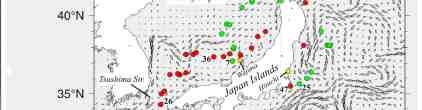
3 Recent field surveys of meso- and microplastics around Japan, and planned surveys Seto Inland Sea ( ) Isobe et al. (2014, Marine Pollution Bull) UMITAKA-Maru (2016/Feb.-Mar.) East Asian Seas around Japan ( ) Isobe et al. (2015, Marine Pollution Bull)
 with a flow meter. The net was towed during 15-20 min.")
4 Sampling & analyses 1. Sampling small plastic fragments using neuston net (0.75 x 0.75 m 2, net size of 350 μm) with a flow meter. The net was towed during min. by research vessels
5 Sampling & analyses 2. Taking pieces of small plastic fragments from sample bottles Fourier transform infrared spectrophotometer (FT-IR alpha; Bruker Optics K.K., Tokyo, Japan) to identify polymer types of plastics

 1mm Particle count")
6 Sampling & analyses 3. Measuring particle count by each size bin of small plastic fragments Particle count per unit seawater volume (measured by flow meter attached at the net mouth) 1mm Particle count (numbers) per unit volume of seawater is estimated.
7 Sampling & analyses 4. Converting the particle count per unit volume (N 0 ; pieces/m 3 ) to total particle count over the water column (M; pieces/km 2 ); otherwise the concentrations depend on oceanic conditions such as waves and their related vertical mixing Observed particle count (pieces/m 3 ) Rise velocity of plastic fragments (experimental values) Reisser et al., 2015, BGS Wave height (observed or computed by wind speed) Wind speed (observed by satellites above the oceans)


8 Sampling at 15 stations in the Seto Inland Sea, Japan Samplings of meso & microplastics using R/V Isana & T/V Yuge were conducted from We first sought oceanic fronts along which plastic debris are accumulated, and thereafter towed a neuston net (350 um)
 76,000 pieces/km")
9 Results stations apart from the river mouth stations apart from the river mouth Microplastics (<5 mm) 76,000 pieces/km 2
 of plastic fragments as a function of their size and distance from the nearest coast.")
10 The size and quantity of mesoplastics gradually increased close to the coast, while microplastics were more dominant as we moved further offshore. Particle count (colors) of plastic fragments as a function of their size and distance from the nearest coast. The samples near the river mouth(h1-3) are NOT used in depicting this figure. Iyo-nada
11 Transport model of meso & microplastics The horizontal motion is governed by random walk (ocean currents & turbulence) and Stokes drift generated by wind waves. Iyo-nada Model concept particle tracking model on vertical 2D plain The vertical motion is governed by terminal velocities dependent on Reynolds number (determined by particle sizes)
12 Procedures 10,000 particles were first released at x=0 km, z=0 m (upper left), and thereafter we compute the motions of all particles until an equilibrium state was reached (5 days). The size composition used for the modeled particles were consistent with those observed in the actual ocean The drift density was examined in the upper 0.75 m, which is the same as the neuston net height used in the present study Particle locations in the 2D plain at 1 hour after (upper) and 24-hours after the beginning of the computation.
 The model including Stokes drift, random walk, and terminal velocities well reproduces the situation that mesoplastics disappear in the offshore.")
13 Particle count (colors) of plastic fragments as a function of their size and distance from the nearest coast. Observed Modeled (normalized by max.) The model including Stokes drift, random walk, and terminal velocities well reproduces the situation that mesoplastics disappear in the offshore.
14 The mesoplastics are selectively conveyed onshore by a combination of Stokes drift and terminal velocity, dependent on fragment sizes. It is suggested that mesoplastics washed ashore on beaches degrade into microplastics, and that the microplastics, which are free from near-shore trapping, are thereafter spread offshore in coastal waters. Isobe et al., (2014) Coastal waters have an effective function for changing mesoplastics to microplastics.


15 Results

16 Results

17 East Asian seas may be a hot spot of microplastics (<5 mm). What transpires in the East Asian seas will eventually materialize in the rest of the world oceans, and thus studies on marine plastic pollution in these areas are of paramount importance. Isobe et al. (MPB, in revision) Eriksen et al. (PLosOne,2014) Isobe et al. (MPB, 2014)
18 We have met many difficulties to model microplastic behavior in nature. Well-organized, and well-standardized surveys are required for validating model results. Of particular importance is to standardize the methodology for severance; otherwise we cannot compare & synthesize observed data corrected by different researchers. East Asian seas may be a hot spot of microplastics (<5 mm). What transpires in the East Asian seas will eventually materialize in the rest of the world oceans, and thus studies on marine plastic pollution in these areas are of paramount importance.
1. Research Institute for Applied Mechanics, Kyushu University, JAPAN 2. Kagoshima University, JAPAN 3. Tokyo University of Science, JAPAN
 An estimate of the tsunami-debris quantity washed ashore on the US and Canadian beaches, based on a webcam monitoring and a particle tracking model experiment Atsuhiko Isobe 1, Shinsuke Iwasaki 1, Shin
Microplastics in the marine environment of coastal British Columbia
 Microplastics in the marine environment of coastal British Columbia Jean-Pierre Desforges 1, Moira Galbraith 2, Neil Dangerfield 2, Peter Ross 1 1 School of Earth and Ocean Sciences, University of Victoria,
Principal Investigator(s), Co-Principal Investigators and Recipient Organization(s):
, Co-Principal Investigators and Recipient Organization(s):") 1. PROJECT INFORMATION Title Webcam monitoring of marine/tsunami debris Award period April 1, 2016 March 31, 2017 Amount of funding 38,000 CAD Report submission date 31 January 2017 Lead Author of Report*
1. PROJECT INFORMATION Title Webcam monitoring of marine/tsunami debris Award period April 1, 2016 March 31, 2017 Amount of funding 38,000 CAD Report submission date 31 January 2017 Lead Author of Report*
Litter in the Israeli coastline. Dynamics of Litter Pollution on Israeli Mediterranean Beaches: A Budgetary, Litter Flux Approach.
 Galia Pasternak Golik, A., Gertner, Y. (1992): Litter in the Israeli coastline. Bowman, D., Manor-Samsonov, N., Golik, A. (1998): Dynamics of Litter Pollution on Israeli Mediterranean Beaches: A Budgetary,
Recommendations by Experts on the Required Parameters for Microplastics Monitoring in the Ocean As of 12 June 2018
 Recommendations by Experts on the Required Parameters for Microplastics Monitoring in the Ocean As of 12 June 2018 The following table shows recommendations on procedures for monitoring microplastics in
Formulation of leeway-drift velocities for sea-surface drifting-objects based on a wind-wave flume experiment
 Formulation of leeway-drift velocities for sea-surface drifting-objects based on a wind-wave flume experiment Atsuhiko Isobe 1, Hirofumi Hinata 2, Shin ichiro Kako 1 and Shun Yoshioka 3 1 Center for Marine
SI Appendix for Plastic debris in the open ocean
 SI Appendix for Plastic debris in the open ocean Authors: Andrés Cózar, Fidel Echevarría, Juan I. González-Gordillo, Xabier Irigoien, Bárbara Úbeda, Santiago Hernández-León, Álvaro T. Palma, Sandra Navarro,
Defri Yona, Syarifah Hikmah Julinda Sari, Feni Iranawati, Syamsul Bachri 3, Wulan Cahya Ayuningtyas 1
 RESEARCH ARTICLE Microplastics in the surface sediments from the eastern waters of Java Sea, Indonesia [version 1; referees: 1 approved] 1,2 1,2 1,2 Defri Yona, Syarifah Hikmah Julinda Sari, Feni Iranawati,
Producing fragmented micro- and nano-plastics from expanded polystyrene with an accelerated mechanical abrasion experiment
 Producing fragmented micro- and nano-plastics from expanded polystyrene with an accelerated mechanical abrasion experiment PICES Annual Meeting 23 Oct 2014 Yeosu, Korea Won Joon Shim 1,2, Young Kyung Song
Section 2.1 Ocean Basins. - Has helped determine where ocean basins are located. - Tectonic plates move changing the position of the continents.
 Science 8 Unit 1: Water Systems on Earth Chapter 2: Oceans Control the Water Cycle Section 2.1 Ocean Basins Oceans are important because: 1. Primary water source for the water cycle 2. Control weather
Geol 117 Lecture 18 Beaches & Coastlines. I. Types of Coastlines A. Definition:
 I. Types of Coastlines A. Definition: 1. Shore = narrow zone where ocean meets land (e.g. beach) 2. Coast is a broad area where both ocean and land processes act a. Includes onshore marshes, dunes, sea
Name Period Part I: INVESTIGATING OCEAN CURRENTS: PLOTTING BUOY DATA
 Name Period Part I: INVESTIGATING OCEAN CURRENTS: PLOTTING BUOY DATA INTRODUCTION: Ocean currents are like huge rivers in the sea. They carry drifting organisms, vital dissolved chemical nutrients and
Notes and Summary pages:
 Topographic Mapping 8.9C Interpret topographical maps and satellite views to identify land and erosional features and predict how these shapes may be reshaped by weathering ATL Skills: Communication taking
Supplemental Slides. Shore: Junction of Land & Water. Junction of Land & Water. Sea Level Variations. Shore vs. Coast. Sea Level Variations
 Shore: Junction of Land & Water Supplemental Slides Sediments come off land Most get dumped at the beach Sediment interacts with ocean waves and currents Junction of Land & Water Features: Breaking waves,
Shore: Junction of Land & Water. Sediments come off land Most get dumped at the beach Sediment interacts with ocean waves and currents
 Shore: Junction of Land & Water Supplemental Slides Sediments come off land Most get dumped at the beach Sediment interacts with ocean waves and currents Junction of Land & Water Features: Breaking waves,
SHORELINE AND BEACH PROCESSES: PART 2. Implications for Coastal Engineering
 SHORELINE AND BEACH PROCESSES: PART 2 Implications for Coastal Engineering Objectives of the lecture: Part 2 Show examples of coastal engineering Discuss the practical difficulties of ocean engineering
SUPPLEMENTARY INFORMATION
 SUPPLEMENTARY INFORMATION Fortnightly atmospheric tides forced by spring and neap tides in coastal waters Shinsuke Iwasaki 1, Atsuhiko Isobe 1 and Yasuyuki Miyao 2 1 Research Institute for Applied Mechanics,
Ocean Remote Sensing (ORS) Programme
 Programme") Ocean Remote Sensing (ORS) Programme Teruhisa KOMATSU Atmosphere and Ocean Research Institute The University of Tokyo W-III 1996 ICAM-P (Huang) Ocean Remote Sensing Programme A history Workshop for ORSP
Ocean Remote Sensing (ORS) Programme Teruhisa KOMATSU Atmosphere and Ocean Research Institute The University of Tokyo W-III 1996 ICAM-P (Huang) Ocean Remote Sensing Programme A history Workshop for ORSP
Himawari-8 True Color RGB
 Himawari-8 True Color RGB Meteorological Satellite Center, JMA Ver. 20150519 What s True Color RGB? R : B03(VS 0.64) G : B02(V2 0.51) 2015-03-17 00UTC B : B01(V1 0.46) Components of True Color RGB Channel
Fukushima nuclear power plant damaged by M9 Earthquake with some focus on ocean
 Fukushima nuclear power plant damaged by M9 Earthquake with some focus on ocean Moto Ikeda (Hokkaido Univ. & JAMSTEC) Oceanographic Society of Japan, Earthquake Disaster Working Group Magnitude-9 earthquake
Managing plastic litter in the marine environment with the help of ocean models
 Managing plastic litter in the marine environment with the help of ocean models Jun She, Jens Murawski, Kostas Tsiaras, Asbjørn Christiansen, Urmas Lips and other WP1 partners BOOS Scientific Workshop
Global Distribution of Microplastics: An Overview
 Global Distribution of Microplastics: An Overview Won Joon Shim a,b*, Sang Hee Hong a,b, Soeun Eo a,b a Oil and POPs Research Group, Korea Institute of Ocean Science and Technology (KIOST) b Department
C o a s t a l p o l l u t i o n
 C o a s t a l p o l l u t i o n Copernicus for Coastal Zone Management and Marine Environment Monitoring Service Copernicus EU Copernicus EU Copernicus EU www.copernicus.eu I N T R O D U C T I O N Main
Simulation of Radioactivity Concentrations in the Sea Area (the 5th report
 Simulation of Radioactivity Concentrations in the Sea Area (the 5th report Press Release May 24, 2011 Ministry of Education, Culture, Sports, Science and Technology 1. Outline The Ministry of Education,
Changes to Land 5.7B. landforms: features on the surface of Earth such as mountains, hills, dunes, oceans and rivers
 All the landforms on Earth have changed over time and continue to change. Many of the changes were caused by wind, moving water, and moving ice. Mountains have grown and shrunk. Rivers have cut away land
A Structure of the Kuroshio and Its Related Upwelling on the East China Sea Shelf Slope
 Journal of Oceanography Vol. 51, pp. 267 to 278. 1995 A Structure of the Kuroshio and Its Related Upwelling on the East China Sea Shelf Slope TOSHIMICHI ITO 1 *, ARATA KANEKO 2, HIROHITO FURUKAWA 3 **,
Think about the landforms where you live. How do you think they have changed over time? How do you think they will change in the future?
 reflect All the landforms on Earth have changed over time and continue to change. Many of the changes were caused by wind, moving water, and moving ice. Mountains have grown and shrunk. Rivers have cut
Microplastics contamination in blue mussels (Mytilus edulis (L.)) and marine sediments along the coast of British Columbia, Canada
) and marine sediments along the coast of British Columbia, Canada") Western Washington University Western CEDAR Salish Sea Ecosystem Conference 2018 Salish Sea Ecosystem Conference (Seattle, Wash.) Apr 5th, 4:30 PM - 4:45 PM Microplastics contamination in blue mussels
Western Washington University Western CEDAR Salish Sea Ecosystem Conference 2018 Salish Sea Ecosystem Conference (Seattle, Wash.) Apr 5th, 4:30 PM - 4:45 PM Microplastics contamination in blue mussels
Efficacy Evaluation of Data Assimilation for Simulation Method of Spilled Oil Drifting
 Proceedings of 5th PAAMES and AMEC2012 Dec. 10-12, 2012, Taiwan Paper No. SEPAS-05 Efficacy Evaluation of Data Assimilation for Simulation Method of Spilled Oil Drifting Satoaki TSUTSUKAWA, Hiroyoshi SUZUKI
A Comparison of Predicted Along-channel Eulerian Flows at Cross- Channel Transects from an EFDC-based Model to ADCP Data in South Puget Sound
 A Comparison of Predicted Along-channel Eulerian Flows at Cross- Channel Transects from an EFDC-based Model to ADCP Data in South Puget Sound Skip Albertson, J. A. Newton and N. Larson Washington State
Interannual Variability of Wind Induced Onshore Transport over the Northern West Florida Shelf
 Interannual Variability of Wind Induced Onshore Transport over the Northern West Florida Shelf Steve Morey Austin Todd Mark Bourassa COAPS/FSU Motivation Understand the physical controls on regional Gag
Simultaneous assessment of macro and micro marine litter pollution in different compartments in the central Adriatic Sea, central Mediterranean sea
 Simultaneous assessment of macro and micro marine litter pollution in different compartments in the central Adriatic Sea, central Mediterranean sea Andreja Palatinus, Manca Kovač Viršek, Mateja Grego,
Multisensor monitoring of Peter the Great Bay
 Multisensor monitoring of Peter the Great Bay Leonid Mitnik, Vyacheslav Dubina, Oleg Konstantinov and Vitaly Fischenko V.I. Il'ichev Pacific Oceanological Institute FEB RAS 43 Baltiyskaya St. 690041 Vladivostok,
Measurement of Airborne Chloride Particle Sizes Distribution for Infrastructures Maintenance
 Measurement of Airborne Chloride Particle Sizes Distribution for Infrastructures Maintenance Nattakorn BONGOCHGETSAKUL * Sachie KOKUBO ** Seigo NASU *** Kochi University of Technology *, **, *** ABTRACT:
Steven Greco* and George D. Emmitt Simpson Weather Associates, Charlottesville, VA. 2. Experiments
 3.3 INVESTIGATION OF FLOWS WITHIN COMPLEX TERRAIN AND ALONG COASTLINES USING AN AIRBORNE DOPPLER WIND LIDAR: OBSERVATIONS AND MODEL COMPARISONS Steven Greco* and George D. Emmitt Simpson Weather Associates,
Map shows 3 main features of ocean floor
 Map shows 3 main features of ocean floor 2017 Pearson Education, Inc. Chapter 3 Marine Provinces 2017 Pearson Education, Inc. 1 Chapter 3 Overview The study of bathymetry determines ocean depths and ocean
HAB Forecaster. For info on HABs in the Pacific Northwest see:
 HAB Forecaster BACKGROUND In this activity, students can take on the role as a resource manager or scientist, tasked with deciding if razor clam harvesters should go out onto the beach to harvest razor
HFR Surface Currents Observing System in Lower Chesapeake Bay and Virginia Coast
 HFR Surface Currents Observing System in Lower Chesapeake Bay and Virginia Coast Larry P. Atkinson, Teresa Garner, and Jose Blanco Center for Coastal Physical Oceanography Old Dominion University Norfolk,
Bathymetry Measures the vertical distance from the ocean surface to mountains, valleys, plains, and other sea floor features
 1 2 3 4 5 6 7 8 9 10 11 CHAPTER 3 Marine Provinces Chapter Overview The study of bathymetry determines ocean depths and ocean floor topography. Echo sounding and satellites are efficient bathymetric tools.
Investigation of submarine groundwater discharge using several methods in the inter-tidal zone
 60 A New Focus on Groundwater Seawater Interactions (Proceedings of Symposium HS1001 at IUGG2007, Perugia, July 2007). IAHS Publ. 312, 2007. Investigation of submarine groundwater discharge using several
Long-term Change of Ocean Productivity: A case study in the Bay of Bengal
 Long-term Change of Ocean Productivity: A case study in the Bay of Bengal The 3 rd Asian /12 th Korean-Japan Workshop on Ocean Color Dr.Md.Latifur Rahman Sarker, UTM, Malaysia & RU, Bangladesh & Noor Saadah
Objectives: Describe the structure of the ocean floor. Describe light intensity and temperature characteristics at different ocean depths.
 Ocean Structure Virtual Lab What are some characteristics of the ocean and the ocean floor? Earths highest mountains, deepest valleys, and flattest plains are found not on land but under the ocean. Beyond
Ice Sheets and Sea Level -- Concerns at the Coast (Teachers Guide)
") Ice Sheets and Sea Level -- Concerns at the Coast (Teachers Guide) Roughly 153 million Americans (~53% of the US population) live in coastal counties. World wide some 3 billion people live within 200 km
Ice Sheets and Sea Level -- Concerns at the Coast (Teachers Guide) Roughly 153 million Americans (~53% of the US population) live in coastal counties. World wide some 3 billion people live within 200 km
Background Field program information Examples of measurements Wind validation for synthetic modeling effort
 Background Field program information Examples of measurements Wind validation for synthetic modeling effort How do complex fine-scale structure and processes in coastal waters dominated by pulsed-river
Mangrove Erosion in the Mekong delta
 Mangrove Erosion in the Mekong delta 1. Introduction a. Mangrove coast - a balance between different forcing factors Mangroves are coastal environments frequently observed in the tropical muddy coasts.
REPORT ON THE TOHOKU AREA PASIFIC OFFSHORE EARTHQUAKE
 REPORT ON THE TOHOKU AREA PASIFIC OFFSHORE EARTHQUAKE GENERAL PERSPECTIVE The Highest Magnitude Ever Recorded The 2011 off the Pacific Coast of Tohoku Earthquake (hereafter, the 2011 Tohoku- Pacific Earthquake
Microplastics in Adriatic region
 Microplastics in Adriatic region Manca Kovač Viršek, Štefan Trdan, Špela Koren Institute for water of the Republic of Slovenia manca.virsek@izvrs.si Microplastics in Adriatic-Ionian region The extent of
Chapter Overview. Bathymetry. Measuring Bathymetry. Measuring Bathymetry
 CHAPTER 3 Marine Provinces Chapter Overview The study of bathymetry determines ocean depths and ocean floor topography. Echo sounding and satellites are efficient bathymetric tools. Most ocean floor features
5. MANY COASTAL COMMUNITIES AND FACILITIES WILL FACE INCREASING EXPOSURE TO STORMS.
 5. MANY COASTAL COMMUNITIES AND FACILITIES WILL FACE INCREASING EXPOSURE TO STORMS. Climate change is altering the Arctic coastline and much greater changes are projected for the future as a result of
MARINE WEATHER HINDCAST REPORT
 MARINE WEATHER HINDCAST REPORT PREPARED FOR US SAILING INVESTIGATIVE PANEL VESSEL : Aegean INCIDENT LOCATION : APPROX 32.45N 117.30W INCIDENT TIME : APPROX 1:30AM Apr. 28 2012 PREPARED BY SAM WILSON M.S.
Week: 4 5 Dates: 9/2 9/12 Unit: Plate Tectonics
 clementaged.weebly.com Name: ODD Period: Week: 4 5 Dates: 9/2 9/12 Unit: Plate Tectonics Monday Tuesday Wednesday Thursday Friday 1 No School 2 E 3 O *Vocabulary *Continental Drift Notes and Sea Floor
Sediment Dispersal from the Apennine Rivers
 Sediment Dispersal from the Apennine Rivers Gail C. Kineke Dept of Geology and Geophysics Boston College Chestnut Hill, MA 02467 phone: 617-552-3655 fax: 617-552-2462 email:kinekeg@bc.edu Award # N00014-02-1-0234
SEDIMENT TRANSPORT IN RIVER MOUTH ESTUARY
 SEDIMENT TRANSPORT IN RIVER MOUTH ESTUARY Katsuhide YOKOYAMA, Dr.Eng. dredge Assistant Professor Department of Civil Engineering Tokyo Metropolitan University 1-1 Minami-Osawa Osawa, Hachioji,, Tokyo,
Plate 51. Site 035. Collection of remains. Scale is in cm. Plate 50. Site 034. Collection of remains. Scale is in cm
 Plate 48. Site 033. View facing north west Plate 49. Site 034. View facing north Pottery Pottery Ostrich eggshell Plate 50. Site 034. Collection of remains. Scale is in cm Plate 51. Site 035. Collection
Name Class Date. The ocean floor has varied and distinct surfaces much like those found on land.
 6 Explore the Seafloor BigIdeas The ocean floor has varied and distinct surfaces much like those found on land. Satellites orbiting Earth, as well as sonar technology, are used to map the seafloor. The
Title. Citation 北海道大学水産科学研究彙報, 64(1): Issue Date Doc URL. Type. File Information
: Issue Date Doc URL. Type. File Information") Title Marine debris observed in the North Pacific during O Mitani, Yoko; Iwahara, Yuka; Otsuki, Mayuko; Nishiza Author(s) Keiko; Mizuno, Hirona; Sakurai, Yasunori Citation 北海道大学水産科学研究彙報, 64(1): 25-29 Issue
Title Marine debris observed in the North Pacific during O Mitani, Yoko; Iwahara, Yuka; Otsuki, Mayuko; Nishiza Author(s) Keiko; Mizuno, Hirona; Sakurai, Yasunori Citation 北海道大学水産科学研究彙報, 64(1): 25-29 Issue
Development of JMA storm surge model
 2 nd JCOMM Scientific and Technical Symposium on Storm Surges 8-13 November 2015, Key West, Florida, USA Development of JMA storm surge model Hiroshi HASEGAWA (h_hasegawa@met.kishou.go.jp) Office of Marine
PREDICTION OF OIL SPILL TRAJECTORY WITH THE MMD-JMA OIL SPILL MODEL
 PREDICTION OF OIL SPILL TRAJECTORY WITH THE MMD-JMA OIL SPILL MODEL Project Background Information MUHAMMAD HELMI ABDULLAH MALAYSIAN METEOROLOGICAL DEPARTMENT(MMD) MINISTRY OF SCIENCE, TECHNOLOGY AND INNOVATION
SAWS: Met-Ocean Data & Infrastructure in Support of Industry, Research & Public Good. South Africa-Norway Science Week, 2016
 SAWS: Met-Ocean Data & Infrastructure in Support of Industry, Research & Public Good South Africa-Norway Science Week, 2016 Marc de Vos, November 2016 South Africa: Context http://learn.mindset.co.za/sites/default/files/resourcelib/e
Carbon pathways in the South Atlantic
 Carbon pathways in the South Atlantic Olga T. Sato, Ph.D. Paulo Polito, Ph.D. olga.sato@usp.br - polito@usp.br Oceanographic Institute University of São Paulo Olga Sato and Paulo Polito (IOUSP) Carbon
QU: Where does sand do jail time? AIM: To explain the sediment cell concept as a system and what human and natural factors create/upset a dynamic
 QU: Where does sand do jail time? AIM: To explain the sediment cell concept as a system and what human and natural factors create/upset a dynamic equilibrium. ST: On your copy draw and label future depositional
Developing integrated remote sensing and GIS procedures for oil spill monitoring on the Libyan coast
 Coastal Processes III 125 Developing integrated remote sensing and GIS procedures for oil spill monitoring on the Libyan coast A. Eljabri & C. Gallagher Department of Civil Engineering and Built Environment,
Masa Kamachi JAMSTEC/CEIST
 Drift simulation of Japan Tsunami Marine Debris (JTMD) as an application of data assimilation 4F.1 Masa Kamachi JAMSTEC/CEIST H. Kawamura, Y. Ishikawa, N. Usui (JAEA) (JAMSTEC) (MRI/JMA) N. Maximenko,
Day Snow-Fog RGB Detection of low-level clouds and snow/ice covered area
 JMA Day Snow-Fog RGB Detection of low-level clouds and snow/ice covered area Meteorological Satellite Center, JMA What s Day Snow-Fog RGB? R : B04 (N1 0.86) Range : 0~100 [%] Gamma : 1.7 G : B05 (N2 1.6)
Healthy Ecosystems Grants 2 Final Report
 Healthy Ecosystems Grants 2 Final Report Project Title: The Transport of Oil to the Coast in the Top Centimeter of the Water Column Award Amount: $432,574 Awardee: Florida State University Award Start
Bifurcation Current along the Southwest Coast of the Kii Peninsula
 Journal of Oceanography, Vol. 54, pp. 45 to 52. 1998 Bifurcation Current along the Southwest Coast of the Kii Peninsula JUNICHI TAKEUCHI 1, NAOTO HONDA 2, YOSHITAKA MORIKAWA 2, TAKASHI KOIKE 2 and YUTAKA
Name: Mid-Year Review #2 SAR
 Name: Mid-Year Review #2 SAR Base your answers to questions 1 through 3 on on the diagram below, which shows laboratory materials used for an investigation of the effects of sediment size on permeability,
The Taiwan-Tsushima Warm Current System: Its Path and the Transformation of the Water Mass in the East China Sea
 Journal of Oceanography, Vol. 55, pp. 185 to 195. 1999 The Taiwan-Tsushima Warm Current System: Its Path and the Transformation of the Water Mass in the East China Sea ATSUHIKO ISOBE Department of Earth
Coasts Key Word Glossary
 Coasts Key Word Glossary Abrasion Also known as corrosion. It is the wearing away of the cliff by sand, fragments of rock and boulders that are being hurled at the cliff by the waves. It causes grinding
Gravity in the Ryukyu Arc*
 Journal of the Geodetic Society of Japan Vol. 22, No. 1, (1976), pp. 23-39 Gravity in the Ryukyu Arc* Jiro SEGAWA Ocean Research Institute, University of Tokyo (Received March 31, 1976; Revised May 22,
Recent improvement plans for JMA wave forecast information and system
 The 14th International workshop on wave forecasting and hind casting and 5th Coastal Hazards Symposium 12/Nov/2015 Recent improvement plans for JMA wave forecast information and system Nadao Kohno Office
Warm Water Intrusion from the Kuroshio into the Coastal Areas South of Japan
 Journal of Oceanography Vol. 49, pp. 607 to 624. 1993 Warm Water Intrusion from the Kuroshio into the Coastal Areas South of Japan AKIHIDE KASAI, SHINGO KIMURA and TAKASHIGE SUGIMOTO Ocean Research Institute,
Original form of plastic when first produced (pre-production)
") 1 Context The Australian Microplastic Assessment Project (AUSMAP) has partnered with NSW Department of Education Environmental & Zoo Education Centres to support the implementation of the AUSMAP citizen
1 Context The Australian Microplastic Assessment Project (AUSMAP) has partnered with NSW Department of Education Environmental & Zoo Education Centres to support the implementation of the AUSMAP citizen
Mark L. Botton 1 and Robert E. Loveland 2
 Sea level rise and the significance of marginal beaches for horseshoe crab spawning Mark L. Botton 1 and Robert E. Loveland 2 1 Fordham University, Dept. Natural Sciences and Environmental Science Program
Subtropical Storm Ana
 Subtropical Storm Ana Threat Assessment for northeast South Carolina & southeast North Carolina Created 745 AM Fri May 8, 2015 Reid Hawkins, Science Officer National Weather Service Wilmington, NC 1 New
Ocean Currents Student Activity Book
 Ocean Currents Student Activity Book I. Introduction Ocean currents influence the weather in coastal areas. They also influence sailing vessels. Though they visibly affect many people's lives, they are
Digitization of the Kobe Collection
 Digitization of the Kobe Collection Akiko Shouji, Takashi Aizawa and Takashi Yoshida Climate and Marine Department, Japan Meteorological Agency Introduction The Japan Meteorological Agency (JMA) carried
Implementation Guides on Sea Area Monitoring
 Implementation Guides on Sea Area. Tasks of sea area monitoring The distribution of radioactive materials is different among seawater, sediment and marine biota. The Table shows the tasks of sea area monitoring,
WIND DATA REPORT FOR THE YAKUTAT JULY 2004 APRIL 2005
 WIND DATA REPORT FOR THE YAKUTAT JULY 2004 APRIL 2005 Prepared on July 12, 2005 For Bob Lynette 212 Jamestown Beach Lane Sequim WA 98382 By John Wade Wind Consultant LLC 2575 NE 32 nd Ave Portland OR 97212
HURRICANE HARVEY COE Navigation BRIEFING
 HURRICANE HARVEY COE Navigation BRIEFING 10:00 AM CDT Friday, August 25, 2017 NWSNewOrleans www.weather.gov/neworleans Situation Overview New Information Harvey continues to strengthen Max sustained winds
Ocean facts continued
 Ocean Facts A dynamic system in which many chemical and physical changes take place Formed over millions of years as precipitation filled low areas on Earth called basins and now covers 70% of the Earth
Day Microphysics RGB Nephanalysis in daytime. Meteorological Satellite Center, JMA
 Day Microphysics RGB Nephanalysis in daytime Meteorological Satellite Center, JMA What s Day Microphysics RGB? R : B04 (N1 0.86) Range : 0~100 [%] Gamma : 1.0 G : B07(I4 3.9) (Solar component) Range :
Read Across America. Listen as I read for facts about Volcanoes. In the Shadow of the Volcano
 Read Across America Listen as I read for facts about Volcanoes. In the Shadow of the Volcano Constructive & Destructive Processes Earth s surface is always changing. Blowing wind and flowing water causes
Using the Mercator ocean forecasting system to compute coastal maritime pollution risk indicators on the Atlantic European coasts
 Environmental Problems in Coastal Regions VI 437 Using the Mercator ocean forecasting system to compute coastal maritime pollution risk indicators on the Atlantic European coasts S. Besnard 1, E. Dombrowsky
Marine plastic pollution and its potential solution - Sustainable tourism
 Sixth Regional 3R Forum in Asia and the Pacific Aug. 18, 2015 Marine plastic pollution and its potential solution - Sustainable tourism Hideshige Takada Laboratory of Organic Geochemistry (LOG) Tokyo University
Sediment and Sedimentary rock
 Sediment and Sedimentary rock Sediment: An accumulation of loose mineral grains, such as boulders, pebbles, sand, silt or mud, which are not cemented together. Mechanical and chemical weathering produces
SUPPLEMENTARY INFORMATION
 Figure S1. Summary of the climatic responses to the Gulf Stream. On the offshore flank of the SST front (black dashed curve) of the Gulf Stream (green long arrow), surface wind convergence associated with
Goal 2: Development of a regional cloud-resolving ensemble analysis and forecast systems ( )
") Goal 2: Development of a regional cloud-resolving ensemble analysis and forecast systems ( ) Meteorological Research Institute, Japan Agency for Marine-Earth Science and Technology, Japan Meteorological
Goal 2: Development of a regional cloud-resolving ensemble analysis and forecast systems ( ) Meteorological Research Institute, Japan Agency for Marine-Earth Science and Technology, Japan Meteorological
Terrain Units PALEOGEOGRAPHY: LANDFORM CREATION. Present Geology of NYS. Detailed Geologic Map of NYS
 NYS TOPOGRAPHY Why so? PALEOGEOGRAPHY: LANDFORM CREATION Prof. Anthony Grande AFG 014 Present Geology of NYS Detailed Geologic Map of NYS Generalized Geology Detailed Geology Hot links to the fold out
Impact of changing Siberian land-shelf-basin on the Arctic Ocean biogeochemical dynamics
 Impact of changing Siberian land-shelf-basin on the Arctic Ocean biogeochemical dynamics PI: Shigeto Nishino (JAMSTEC) Co-PI: Igor Semiletov (IARC/UAF) Other Investigators: Natalia Shakhova (IARC/UAF),
Coastal Ocean Circulation Experiment off Senegal (COCES)
") DISTRIBUTION STATEMENT A. Approved for public release; distribution is unlimited. Coastal Ocean Circulation Experiment off Senegal (COCES) Pierre-Marie Poulain Istituto Nazionale di Oceanografia e di Geofisica
DISTRIBUTION STATEMENT A. Approved for public release; distribution is unlimited. Coastal Ocean Circulation Experiment off Senegal (COCES) Pierre-Marie Poulain Istituto Nazionale di Oceanografia e di Geofisica
Homework 5: Background Ocean Water Properties & Stratification
 14 August 2008 MAR 110 HW5: Ocean Properties 1 Homework 5: Background Ocean Water Properties & Stratification The ocean is a heterogeneous mixture of water types - each with its own temperature, salinity,
Water percolating through hot lava dissolves soluble minerals containing chlorine, bromine and sulphur compounds
 Figure 5 The sources of dissolved ions in sea water. Water falls as rain Compounds containing mainly calcium, magnesium, carbonate and silicate ions are leached from the soil Rivers carry ions in solution
Chapter 17. Ocean and Coastal Processes
 Chapter 17 Ocean and Coastal Processes Ocean Basins and Plates Ocean Basins Ocean Basins are profoundly different from the continents. Ocean crust is thin and dense and young. New ocean crust is generated
Red Sea - Dead Sea Water Conveyance Study Program Additional Studies
 Red Sea - Dead Sea Water Conveyance Study Program Additional Studies Red Sea Study Final Report Annex 1 Field and laboratory activities carried out during the study and their results July 213 TABLE OF
Phillip Island Nature Parks Coastal Process Study 8 October 2014
 Phillip Island Nature Parks Coastal Process Study 8 October 2014 Project Overview Coastal Geology Basaltic and fragmented lavas, granite at Pyramid Rock and Cape Woolamai Weathered basalt (>10m thick)
Satellite-based Red-Tide Detection/Monitoring
 Satellite-based Detection/Monitoring Contents 1. Introduction - and Its Monitoring System 2. Detection Using Ocean Color Remote Sensing 3. Satellite-Based Monitoring in the Asian Coastal Seas Hiroshi KAWAMURA
Chapter Two. Figure 02_02. Geography of the Ocean Basins. The Sea Floor
 Chapter Two The Sea Floor Geography of the Ocean Basins Figure 02_02 The world ocean is the predominant feature on the Earth in total area. In the Northern Hemisphere, 61% of the total area is ocean. In
Comparison between vertical shear mixing and surface wave-induced mixing in the global ocean
 Comparison between vertical shear mixing and surface wave-induced mixing in the global ocean Fangli Qiao and Chuanjiang Huang Key Laboratory of Marine Science and Numerical Modeling First Institute of
Kohei Arai 1 1Graduate School of Science and Engineering Saga University, Saga City, Japan
 (IJARAI) International Journal of Advanced Research in Artificial Intelligence, Vol. 4, No.7, 21 Trend Analysis of Relatively Large Diatoms Which Appear in the Intensive Study Area of the Ariake Sea, Japan