Wireline Logs and Core Data Integration in Los Molles Formation, Neuquen Basin, Argentina L. P. Stinco, CAPSA Capex
|
|
|
- Maryann Annabelle McLaughlin
- 5 years ago
- Views:
Transcription

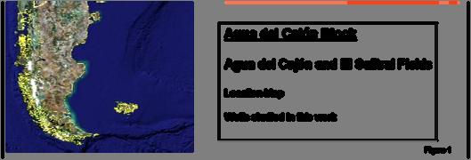
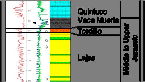
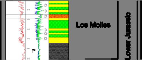
1 SPE Wireline Logs and Core Data Integration in Los Molles Formation, Neuquen Basin, Argentina L. P. Stinco, CAPSA Capex Copyright 2007, Society of Petroleum Engineers This paper was prepared for presentation at the 2007 SPE Latin American and Caribbean Petroleum Engineering Conference held in Buenos Aires, Argentina, April This paper was selected for presentation by an SPE Program Committee following review of information contained in an abstract submitted by the author(s). Contents of the paper, as presented, have not been reviewed by the Society of Petroleum Engineers and are subject to correction by the author(s). The material, as presented, does not necessarily reflect any position of the Society of Petroleum Engineers, its officers, or members. Papers presented at SPE meetings are subject to publication review by Editorial Committees of the Society of Petroleum Engineers. Electronic reproduction, distribution, or storage of any part of this paper for commercial purposes without the written consent of the Society of Petroleum Engineers is prohibited. Permission to reproduce in print is restricted to an abstract of not more than 300 words; illustrations may not be copied. The abstract must contain conspicuous acknowledgment of where and by whom the paper was presented. Write Librarian, SPE, P.O. Box , Richardson, Texas U.S.A., fax Abstract In Agua del Cajón Block (Neuquen Basin, Argentina), petrophysical data was treated according to deductive and inductive methods in order to get the most from both approaches. Deductive methods comprise those methodologies that seek to differentiate the data by the computation of a set of component proportions whose identification is linked with wireline log data by a set of response equations. The model is built considering the number of components and the number of variables (data curves). Normally, measures to detect mismatches and gross errors are included in the techniques, although mathematical consistency is not a guarantee of geological accuracy. This situation is well represented by standard log analysis. On the contrary, inductive methods establish their classes or transformations based on the data set and do not depend on any predetermined correlation among the components. These methods tend to isolate distinctive patterns and to derive classifications or new variables that can be interpreted with a physical meaning. Cluster analysis is one example of these types of methodologies. In this study, wireline logs (spontaneous potential, gamma ray, shallow-medium and deep resistivities, neutron, density, sonic, photoelectric factor, and microrresistivity images) were calibrated according to the lithological variations facies- described in cores taken from the reservoirs developed within Los Molles Formation. These facies which comprised crudely bedded gravel with imbrication (Gm), medium to coarse, even pebbly sand with planar crossbeds (Sp), very fine to very coarse sand with horizontal lamination (Sh) and massive mud-silt (Fm), were linked with electrofacies using multivariate analysis, particularly cluster analysis. The first two facies are the actual reservoirs targets within the field. After the analysis of ten wells within the field, a more thorough understanding of the petrophysical properties and a deeper understanding of the dynamic responses of the reservoirs was achieved. Introduction Agua del Cajón Block (Figure 1) is situated to the west of Neuquen city in the central part of the Neuquen basin. Within the block, two main fields are currently on production: El Salitral and Agua del Cajón. These fields were discovered in 1965 and 1973 respectively by YPF and operated by the state oil company until 1991 when Capex took over the operation. Currently, there are more than 300 wells in an area of 355 square kilometers. Hydrocarbons in Agua del Cajón Block are structural and stratigraphically trapped within a variety of reservoirs developed in Cretaceous and Jurassic formations (Figure 2). The units comprise conglomerates, sandstones and shales interpreted as being deposited in a variety of environments such as alluvial fans, fluvial, deltaic and submarine fans 1. The submarine fan deposits of the Los Molles Formation are analyzed in this work. In 10 wells of the field, formation evaluation and electrofacies determination were performed by applying an appropriate set of inductive and deductive methodologies. These ones comprised a number of procedures including data editing and normalization of the log data, standard log analysis and electrofacies determination. The analysis procedures were optimized with the help of cutting descriptions, cores and production test data. K-means cluster analysis in three dimensions was used to define four electrofacies which were calibrated according to the facies described in cores. Two of the facies are the actual reservoir targets within the field therefore this study helped in understanding the dynamic response of the reservoirs all over the field. Methodology The petrophysical data processing and analysis was performed following a number of interrelated procedures highly dependent on the quantity and quality of the data. This methodology comprises a number of procedures including: data editing and normalization of the log data,
2 2 SPE standard log analysis, electrofacies determination and summations. The wells in the study area have spontaneous potential, gamma ray, shallow-medium and deep resistivities, neutron, density, sonic and photoelectric factor. Microrresistivity images were available in just two of them. Wireline log data was from several different vendors. The differences in response due to tool types used by each logging company were accounted for during the environmental corrections and log normalization procedure. The petrophysical data was treated following deductive and inductive methods in order to get the most from both approaches. Deductive methods comprise those methodologies that seek to differentiate the data by the computation of a set of component proportions whose identification is linked with wireline log data by some suite of response equations 2. The model is built considering the number of components and the number of variables (data curves). Normally, measures to detect mismatches and gross errors are included in the techniques although mathematical consistency is not a guarantee of geological accuracy. This situation is well represented by standard log analysis. On the contrary, inductive methods establish their classes or transformations based on the data set and do not depend on any predetermined correlation among the components. These methods tend to isolate distinctive patterns and to derive classifications or new variables that can be interpreted with a physical meaning. Cluster analysis is one example of this type of methodologies. Log Data Editing and Normalization Before starting to analyze the wireline log data, the following subtasks were performed: edition of the digital wireline log data including re-sampling to a common increment where necessary; comparison of the digital data with the paper logs and repaired where differences occurred; merging of logging runs choosing the best data from any overlaps or repeat sections; performing standard editing to remove obvious data errors and spikes; performing depth shifting for each logging suite to the resistivity suite; removing SP drift; performing environmental corrections; depth shifting of all core data to logs and added to the database; plotting out crossplots and histograms of all curves. Practice in using well log analysis as part of integrated reservoir studies has shown that multiwell normalization is necessary to ensure that results are accurate, consistent and comparative well-to-well. Once normalized, wireline log data can be effectively integrated, correlated and calibrated with core data. Consequently, correlations can be extended vertically to include layers that were not cored, and laterally to wells across the study area 3. Standard Log Analysis The petrophysical model comprises sandstones + siltstones + tuffs + shales + porosity. The term sandstones includes a variety of lithologies (clusters of electrofacies not yet defined) that certainly are reservoirs. For estimation of shale volume, the SP drift corrected and the GR were used. The total porosity was estimated from the neutron-density crossplot and the effective porosity was calculated from the total porosity by applying a correction proportional to the shale content. Water saturation was estimated using the Simandoux model 4. Cementation (m=2) and saturation (n=2) exponents were taken from standard core analysis results. Water salinity values, taken from measurements of produced water samples, were of 70,000 ppm. In figure 3 a standard log analysis presents a comparison between core and log porosity. Additionally, it includes water saturation and volume of mineral estimation. The saturation model was accepted as valid through a direct comparison of the estimated results against production data. Electrofacies Determination The term electrofacies was originally defined as a set of log responses that characterizes a bed and permits to distinguish from the others 5. They are determined by the physical properties of rocks to which the wireline logs are sensitive. It is worthy to mention that there exists a conceptual difference between electrofacies and geological facies related to their genesis. Electrofacies are based on characteristics taken from continuous remote measurements at scales of one meter and higher, whereas geological facies are based primarily on observational characteristics taken at scales down to millimeters 6. Therefore, electrofacies is a set of technologies used to recognize rock types with common properties. These electrofacies are typically used to provide assistance in performing sequence stratigraphy and correlations. In addition they can be used to assign relationships for each rock type such as porosity/permeability equations. References 2, 5, 6, 7, 8 and 9 suggest to use cluster analysis in n dimensions with each wireline log as a dimension for determining electrofacies. Cluster Analysis Cluster analysis is one of the most common multivariate techniques found. Conceptually, it is based upon the fact that data can be clustered within groups that differ according to a specific meaning 2. Particularly, within a proper geological framework, dealing with petrophysical variables and measurement parameters, it is possible to find a logical meaning for each of them independently of the working scale. In order to cluster the data it is necessary to follow a set of procedures. First, the data matrix of n x p (p variables at n depths) is changed into a matrix of n x n similar distances between pairs of data from the overall. Secondly, a cluster method must be selected. In this study, the K-means technique was used 10. The K- means approach is a special case of a general approach called the EM (expectation and maximization) algorithm 11. Given a specific number of clusters, this
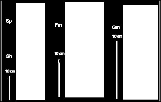
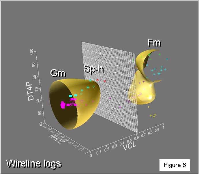
3 SPE method is practical for much bigger data sets than any other algorithm. This approach repeatedly alternates between cluster assignment and re-estimating cluster centers. The user must choose the number of clusters to find. The system then populates the n dimensions with the same number of points approximately evenly spaced throughout the data. The iterative steps then move the points toward the data populations (like gravitational attraction) until no more movement occurs. The final positions of the points are then taken to be the central position of each cluster in the data. The potential capability to use multivariate analysis to distinguish different electrofacies and consequently to link them with the facies recognized in the core was tested. Having validated the petrophysical model, the following steps included facies analysis from cores and electrofacies determination from wireline logs. Core data was available in well ADC The thorough paleoenvironmental interpretation 12 describes crudely bedded gravel with imbrication (Gm), medium to coarse, even pebbly sand with planar crossbeds (Sp), very fine to very coarse sand with horizontal lamination (Sh) and massive mud-silt (Fm). Figure 4 shows examples of the facies encountered in the core. The number of wireline logs finally used was reduced to the minimum common logs run in all the wells: compresional transit time, density and a computed volume of clay derived from SP and GR. Having selected the curves to use, it was necessary to verify that all the facies described in the core could be clustered using the correspondent curves. As it is shown in figure 5 it is feasible to cluster each depositional environment described in the core in a space defined by the selected curves. Hence, it is possible at this stage, to apply multivariate analysis in order to cluster all data independently of the core descriptions. The number of clusters was varied and the results compared with geological data (drill cutting descriptions, core descriptions, and thin sections) and production data until an optimal set of electrofacies was found for the calibration well. Several different numbers of clusters were tried (12 clusters, 9 clusters and 7 clusters) against the chosen log curves. The optimal set preferred contained three electrofacies from seven clusters as being an appropriate number that resolved the most relevant facies. Figure 6 shows the clusters in a two dimensional crossplot. A comprehensive analysis of figures 5 and 6 revealed that there was a direct correlation among geological facies with electrofacies. From the central position of each cluster was possible to determine the exact value of every wireline log that characterizes different electrofacies. A software that solves the wireline logs responses for the central points defined for each cluster was used in order to effectively determine electrofacies 13. The original number of clusters (7) was reduced to 3 due to the limited quantity of curves available. This selection process involved grouping of the clusters that were closer and behaved consistently from a geological point of view as well as discarding those of very limited representation in a number of individuals. Table 1 shows the central points used for each electrofacies. Figures 7 and 8 show the electrofacies determination together with the core description. These figures shows the consistency of the different facies-electrofacies relationship. Figure 9 presents the standard log evaluation and the electrofacies determination in the same figure. Results Summations in the reservoirs within the Los Molles Formations were performed for the 10 wells analyzed. The data was used as input for the geological modeling and property maps were generated for the petrophysical variables. The geological model could now be supported by the petrophysical study. Variations in net to gross (10% to 23%), porosities (5% to 10%) and shale content (15% to 55%) could now be explained properly. Test results were consistent with the determined electrofacies. Conclusions 1. A direct comparison among cutting descriptions, core data, production and seismic data with the results obtained from the standard log analysis and the electrofacies determination provided a useful tool for achieving a better understanding of the reservoirs developed within Los Molles Formation. 2. The geological facies recognized in the core have an electrical expression that could be used to interpret the reservoir behaviour in the block. 3. Dynamic behaviour of the reservoirs reflects the petrophysical conditions of the rocks which are controlled by the geological facies. Acknowledgements The author wishes to thank CAPSA-Capex for permission to publish this paper. Also G. Pando, C. Gómez and R. García for the valuable comments made during the study. References 1. Zumel, J. et al: Los reservorios del Grupo Cuyo Inferior, in Rocas Reservorio de las Cuencas Productivas de la Argentina, Simposio del V Congreso de Exploración y Desarrollo de Hidrocarburos, Schiuma, Hinterwimmer y Vergani (editores), IAPG (2002). 2. Moss, B.: The partitioning of petrophysical data: a review. In Developments in Petrophysics. Geological Society Special Publication N 122. Ed: M. Lovell and P. Harvey. The Geological Society, London (1997). 3. Hunt, E. et al: Fundamentals of log analysis. Part V: Normalizing logs with histograms. World Oil (October, 1996).
4 4 SPE Simandoux, P. Measures diélectrique en milie poreaux, application à mesure de saturation en eau, etude des massifs argileaux. Reveu de l Institut Française du Pétrole: (1963) Serra, O. and Abbot, H.: The contribution of logging data to sedimentology and stratigraphy paper SPE 9270 presented at the th Annual Fall Technical Conference and Exhibition, Dallas, Texas. 6. Doveton, J.: Geologic Log Analysis Using Computer Methods. AAPG Computer Applications in Geology, N 2. AAPG, Tulsa, Oklahoma (1994) Elphick, R and R. Moore: "Permeability Calculations from Clustered Electrofacies, A case Study in Lake Maracaibo, Venezuela." presented at the 1999 SPWLA Annual Symposium, Oslo. 8. Stinco, L. et al. Electrofacies and production prediction index determination in El Tordillo Field, San Jorge Basin, Argentina. Presented at the nd SPWLA Annual Symposium, Houston, USA. 9. Stinco, L. Core and log data integration. The key for determining electrofacies. Presented at the th SPWLA Annual Symposium, Veracruz, México. 10. Hartigan, J. and M. Wong. A K-means clustering algorithm. Applied statistics 28, (1979) SAS. JMP Statistical Discovery Software. Statistics and Graphics Guide. Cary, NC, (2000) 634 pp. 12. Miall, A. Principles of Sedimentary Basin Analysis, Springer-Verlag (1978) Mitchell, W. and R. Nelson. A practical approach to statistical log analysis, paper S. Presented at the th SPWLA Annual Symposium.


5 SPE Table 1

6 6 SPE
7 SPE
EXTENDED ABSTRACT EVALUATING THE SHALY SAND OIL RESERVOIRS OF EL TORDILLO FIELD, ARGENTINA, USING MAGNETIC RESONANCE LOGS
 EXTENDED ABSTRACT EVALUATING THE SHALY SAND OIL RESERVOIRS OF EL TORDILLO FIELD, ARGENTINA, USING MAGNETIC RESONANCE LOGS Maged Fam, Halliburton Energy Services, Luis P. Stinco, and Julio. A. Vieiro, Tecpetrol
SPE These in turn can be used to estimate mechanical properties.
 SPE 96112 Pressure Effects on Porosity-Log Responses Using Rock Physics Modeling: Implications on Geophysical and Engineering Models as Reservoir Pressure Decreases Michael Holmes, SPE, Digital Formation,
OTC OTC PP. Abstract
 OTC OTC-19977-PP Using Modern Geophysical Technology to Explore for Bypassed Opportunities in the Gulf of Mexico R.A. Young/eSeis; W.G. Holt, G. Klefstad/ Fairways Offshore Exploration Copyright 2009,
An Integrated Approach to Volume of Shale Analysis: Niger Delta Example, Orire Field
 World Applied Sciences Journal 7 (4): 448-452, 2009 ISSN 1818-4952 IDOSI Publications, 2009 An Integrated Approach to Volume of Shale Analysis: Niger Delta Example, Orire Field 1 1 2 L. Adeoti, E.A. Ayolabi
PETROPHYSICAL EVALUATION CORE COPYRIGHT. Petrophysical Evaluation Approach and Shaly Sands Evaluation. By the end of this lesson, you will be able to:
 PETROPHYSICAL EVALUATION CORE Petrophysical Evaluation Approach and Shaly Sands Evaluation LEARNING OBJECTIVES By the end of this lesson, you will be able to: Discuss how to approach a petrophysical evaluation
Verification of Archie Constants Using Special Core Analysis and Resistivity Porosity Cross Plot Using Picket Plot Method
 Int'l Journal of Computing, Communications & Instrumentation Engg. (IJCCIE) Vol. 4, Issue (207) ISSN 2349-469 EISSN 2349-477 Verification of Archie Constants Using Special Core Analysis and Resistivity
Search and Discovery Article #20045 (2007) Posted September 3, 2007
 Posted September 3, 2007") Fracture Modeling in a Dual Porosity Volcaniclastic Reservoir: A Case Study of the Precuyo Group in Cupen Mahuida field, Neuquén, Argentina* By Martin Zubiri 1 and José Silvestro 1 Search and Discovery
Fracture Modeling in a Dual Porosity Volcaniclastic Reservoir: A Case Study of the Precuyo Group in Cupen Mahuida field, Neuquén, Argentina* By Martin Zubiri 1 and José Silvestro 1 Search and Discovery
Seismic Guided Drilling: Near Real Time 3D Updating of Subsurface Images and Pore Pressure Model
 IPTC 16575 Seismic Guided Drilling: Near Real Time 3D Updating of Subsurface Images and Pore Pressure Model Chuck Peng, John Dai and Sherman Yang, Schlumberger WesternGeco Copyright 2013, International
Geological Classification of Seismic-Inversion Data in the Doba Basin of Chad*
 Geological Classification of Seismic-Inversion Data in the Doba Basin of Chad* Carl Reine 1, Chris Szelewski 2, and Chaminda Sandanayake 3 Search and Discovery Article #41899 (2016)** Posted September
Evaluation of Rock Properties from Logs Affected by Deep Invasion A Case Study
 Evaluation of Rock Properties from Logs Affected by Deep Invasion A Case Study Jahan Zeb a, Reece Murrell b a CGG Australia, 1 Ord Street, West Perth, WA 6005 Contact email: Jahan.Zeb@cgg.com b Esso Australia,
Stochastic Modeling & Petrophysical Analysis of Unconventional Shales: Spraberry-Wolfcamp Example
 Stochastic Modeling & Petrophysical Analysis of Unconventional Shales: Spraberry-Wolfcamp Example Fred Jenson and Howard Rael, Fugro-Jason Introduction Recent advances in fracture stimulation techniques
Constraining Uncertainty in Static Reservoir Modeling: A Case Study from Namorado Field, Brazil*
 Constraining Uncertainty in Static Reservoir Modeling: A Case Study from Namorado Field, Brazil* Juliana F. Bueno 1, Rodrigo D. Drummond 1, Alexandre C. Vidal 1, Emilson P. Leite 1, and Sérgio S. Sancevero
Advances in Elemental Spectroscopy Logging: A Cased Hole Application Offshore West Africa
 Journal of Geography and Geology; Vol. 9, No. 4; 2017 ISSN 1916-9779 E-ISSN 1916-9787 Published by Canadian Center of Science and Education Advances in Elemental Spectroscopy Logging: A Cased Hole Application
Process, Zeit Bay Fields - Gulf of Suez, Egypt*
 PS Pressure Regime Evaluation, Role, and Contribution in Well Planning and Formation Evaluation Process, Zeit Bay Fields - Gulf of Suez, Egypt* Saber Moustafa Selim 1, Khaled Mohamed Abdallah 1, and Khalaf
Abstract. Introduction to Area
 Petro physical analysis of Habib Rahi Limestone of Mari Gas Field using open hole wire line logs of well Mari Deep -06 Central Indus Basin Pakistan (A Case Study) 1a Quaid Khan Jadoon, 1a Muhammad Zahid
GY 402: Sedimentary Petrology
 UNIVERSITY OF SOUTH ALABAMA GY 402: Sedimentary Petrology Lecture 27: Introduction to Wireline Log Interpretations Instructor: Dr. Douglas W. Haywick Last Time Carbonate Diagenesis Diagenesis 0.5 mm PPL
Petrophysical Rock Typing: Enhanced Permeability Prediction and Reservoir Descriptions*
 Petrophysical Rock Typing: Enhanced Permeability Prediction and Reservoir Descriptions* Wanida Sritongthae 1 Search and Discovery Article #51265 (2016)** Posted June 20, 2016 *Adapted from oral presentation
Reservoir Rock Properties COPYRIGHT. Sources and Seals Porosity and Permeability. This section will cover the following learning objectives:
 Learning Objectives Reservoir Rock Properties Core Sources and Seals Porosity and Permeability This section will cover the following learning objectives: Explain why petroleum fluids are found in underground
Comparison of Classical Archie s Equation with Indonesian Equation and Use of Crossplots in Formation Evaluation: - A case study
 P-310 Summary Comparison of Classical Archie s Equation and Use of Crossplots in Formation Evaluation: - A case study Nitin Sharma In petroleum Exploration and Development Formation Evaluation is done
EMEKA M. ILOGHALU, NNAMDI AZIKIWE UNIVERSITY, AWKA, NIGERIA.
 Automatic classification of lithofacies and interpretation of depositional environment using Neural Networks Technique - A Novel Computer-Based methodology for 3-D reservoir geological modelling and exploration
Evaluation of Low Resistivity Laminated Shaly Sand Reservoirs
 Evaluation of Low Resistivity Laminated Shaly Sand Reservoirs Summary Dr S S Prasad, C S Sajith & S S Bakshi Sub Surface Team, Mehsana Asset, ONGC, Palavasna, Mehsana, Gujarat E-mail : shivshankarp@gmailcom
RESERVOIR CHARACTERIZATION USING SEISMIC AND WELL LOGS DATA (A CASE STUDY OF NIGER DELTA)
") RESERVOIR CHARACTERIZATION USING SEISMIC AND WELL LOGS DATA (A CASE STUDY OF NIGER DELTA) * ESHIMOKHAI, S. and AKHIREVBULU, O.E. http://dx.doi.org/10.4314/ejesm.v5i4.s20 Received 19th June 2012; accepted
RESERVOIR CHARACTERIZATION USING SEISMIC AND WELL LOGS DATA (A CASE STUDY OF NIGER DELTA) * ESHIMOKHAI, S. and AKHIREVBULU, O.E. http://dx.doi.org/10.4314/ejesm.v5i4.s20 Received 19th June 2012; accepted
Characteristics of the Triassic Upper Montney Formation (Unit C), West-Central Area, Alberta
, West-Central Area, Alberta") Characteristics of the Triassic Upper Montney Formation (Unit C), West-Central Area, Alberta Omar Derder NeoSeis Technology Group Ltd., Calgary, Alberta omarderder@neoseis.com Abstract Unconventional hydrocarbon
Characteristics of the Triassic Upper Montney Formation (Unit C), West-Central Area, Alberta Omar Derder NeoSeis Technology Group Ltd., Calgary, Alberta omarderder@neoseis.com Abstract Unconventional hydrocarbon
SPE Uncertainty in rock and fluid properties.
 SPE 77533 Effects on Well Test Analysis of Pressure and Flowrate Noise R.A. Archer, University of Auckland, M.B. Merad, Schlumberger, T.A. Blasingame, Texas A&M University Copyright 2002, Society of Petroleum
Petrophysical Charaterization of the Kwale Field Reservoir Sands (OML 60) from Wire-line Logs, Niger Delta, Nigeria. EKINE, A. S.
 from Wire-line Logs, Niger Delta, Nigeria. EKINE, A. S.") JASEM ISSN 1119-8362 All rights reserved Full-text Available Online at wwwbiolineorgbr/ja J Appl Sci Environ Manage December, 2009 Vol 13(4) 81-85 Petrophysical Charaterization of the Kwale Field Reservoir
JASEM ISSN 1119-8362 All rights reserved Full-text Available Online at wwwbiolineorgbr/ja J Appl Sci Environ Manage December, 2009 Vol 13(4) 81-85 Petrophysical Charaterization of the Kwale Field Reservoir
egamls Inc. What we do: Well and field studies using GAMLS software (plus GAMLS licensing)
") egamls Inc. Principals: Eric Eslinger (Geologist/Petrophysicist) and Alan Curtis (Reservoir Engr/Geomodeller) What we do: Well and field studies using GAMLS software (plus GAMLS licensing) GAMLS focus:
egamls Inc. Principals: Eric Eslinger (Geologist/Petrophysicist) and Alan Curtis (Reservoir Engr/Geomodeller) What we do: Well and field studies using GAMLS software (plus GAMLS licensing) GAMLS focus:
1996 SCA Conference Paper Number 9641 ABSTRACT
 An ntegrated Approach To Determine Shale Volume And Hydrocarbon Potential n Shaly Sand G.M. Hamada * ABSTRACT One of the most controversial problems in formation evaluation is the shale effect in reservoir
Contents. Introduction. Introduction. Modern Environments. Tools for Stratigraphic Analysis
 Contents Tools for Stratigraphic Analysis Introduction of Study: Modern Environments of Study: Ancient Deposits Summary Introduction Basin analysts use a variety of methods to study modern and ancient
N121: Modern Petrophysical Well Log Interpretation
 Summary This course presents the principles and methods associated with the petrophysical interpretation of openand cased-hole wireline and LWD well logs. Open-hole topics covered include the use of log
Sequence Stratigraphy of the Upper Cretaceous Niobrara Formation, A Bench, Wattenberg Field, Denver Julesburg Basin, Colorado*
 Sequence Stratigraphy of the Upper Cretaceous Niobrara Formation, A Bench, Wattenberg Field, Denver Julesburg Basin, Colorado* Lisa E. Remington LaChance 1 and Mark C. Robinson 1 Search and Discovery Article
SPE Introduction
 SPE 69485 Lateral and Vertical Discrimination of Thin-Bed Fluvial Reservoirs: Geostatistical Inversion of a 3D Seismic Data Set Marcos Victoria, German Merletti, REPSOL-YPF, Alvaro Grijalba Cuenca,SPE,
FORMATION EVALUATION OF SIRP FIELD USING WIRELINE LOGS IN WESTERN DEPOBELT OF NIGER DELTA
 FORMATION EVALUATION OF SIRP FIELD USING WIRELINE LOGS IN WESTERN DEPOBELT OF NIGER DELTA 1 Obioha C, ²Adiela U. P and ³*Egesi N 1,3 Department of Geology, Faculty of Science, University of Port Harcourt,
LITTLE ABOUT BASIC PETROPHYSICS
 LITTLE ABOUT BASIC PETROPHYSICS Author: MUHAMMAD ZAHID M.Sc (Applied Geology) Specialization in Petrophysics University of Azad Jammu & Kashmir, Muzaffarabad. ENTER Introduction - Determination of Physical
RESERVOIR SEISMIC CHARACTERISATION OF THIN SANDS IN WEST SYBERIA
 www.senergyltd.com RESERVOIR SEISMIC CHARACTERISATION OF THIN SANDS IN WEST SYBERIA Erick Alvarez, Jaume Hernandez, Bolkhotivin E.A., Belov A.V., Hakima Ben Meradi,Jonathan Hall, Olivier Siccardi, Phil
SEG/New Orleans 2006 Annual Meeting
 Carmen C. Dumitrescu, Sensor Geophysical Ltd., and Fred Mayer*, Devon Canada Corporation Summary This paper provides a case study of a 3D seismic survey in the Leland area of the Deep Basin of Alberta,
Handbook Of Well Log Analysis For Oil And Gas Formation Evaluation
 Handbook Of Well Log Analysis For Oil And Gas Formation Evaluation Statistics of Oil and Gas Development and Production (8 volumes), 1946-1952, 1958, AIME publication, hardbound in excellent condition
Simultaneous Inversion of Clastic Zubair Reservoir: Case Study from Sabiriyah Field, North Kuwait
 Simultaneous Inversion of Clastic Zubair Reservoir: Case Study from Sabiriyah Field, North Kuwait Osman Khaled, Yousef Al-Zuabi, Hameed Shereef Summary The zone under study is Zubair formation of Cretaceous
Downloaded 09/15/16 to Redistribution subject to SEG license or copyright; see Terms of Use at
 A Full Field Static Model of the RG-oil Field, Central Sirte Basin, Libya Abdalla Abdelnabi*, Kelly H. Liu, and Stephen Gao Missouri University of Science and Technology Summary Cambrian-Ordovician and
Hydrocarbon Volumetric Analysis Using Seismic and Borehole Data over Umoru Field, Niger Delta-Nigeria
 International Journal of Geosciences, 2011, 2, 179-183 doi:10.4236/ijg.2011.22019 Published Online May 2011 (http://www.scirp.org/journal/ijg) Hydrocarbon Volumetric Analysis Using Seismic and Borehole
Geology Stratigraphic Correlations (Lab #4, Winter 2010)
") Name: Answers Reg. lab day: Tu W Th Geology 1023 Stratigraphic Correlations (Lab #4, Winter 2010) Introduction Stratigraphic correlation is the process of comparing rocks at one locality with related rocks
Name: Answers Reg. lab day: Tu W Th Geology 1023 Stratigraphic Correlations (Lab #4, Winter 2010) Introduction Stratigraphic correlation is the process of comparing rocks at one locality with related rocks
NAPE 2011 Lagos, Nigeria 28 November-2 December 2011 Extended Abstract
 T: +44 191 334 2191 E: info@ikonscience.com W: www.ikonscience.com Pore Pressure Prediction in the Niger Delta NAPE 2011 Lagos, Nigeria 28 November-2 December 2011 Extended Abstract PORE PRESSURE PREDICTION
GEOLOGICAL LOG INTERPRETATION TUTORIAL
 GEOLOGICAL LOG INTERPRETATION TUTORIAL Text and Figures by Geoff Bohling and John Doveton The following pages will familiarize you with the basics of the geological interpretation of common logs as they
Porosity. Downloaded 09/22/16 to Redistribution subject to SEG license or copyright; see Terms of Use at
 Geostatistical Reservoir Characterization of Deepwater Channel, Offshore Malaysia Trisakti Kurniawan* and Jahan Zeb, Petronas Carigali Sdn Bhd, Jimmy Ting and Lee Chung Shen, CGG Summary A quantitative
Quantitative Seismic Interpretation An Earth Modeling Perspective
 Quantitative Seismic Interpretation An Earth Modeling Perspective Damien Thenin*, RPS, Calgary, AB, Canada TheninD@rpsgroup.com Ron Larson, RPS, Calgary, AB, Canada LarsonR@rpsgroup.com Summary Earth models
GeoCanada 2010 Working with the Earth
 Lithofacies Identification and the Implications for SAGD Well Planning in the McMurray Formation, Christina Lake Area, Alberta Travis Shackleton*, Robert Gardner, Sung Youn, Grace Eng and Lori Barth Cenovus
Applying Stimulation Technology to Improve Production in Mature Assets. Society of Petroleum Engineers
 Applying Stimulation Technology to Improve Production in Mature Assets Alexandr Mocanu Well Production Services, Schlumberger Visegrád, 19 November 2015 Society of Petroleum Engineers 1 Agenda Formation
Formation Evaluation: Logs and cores
 These powerpoint files were produced for the Earth History class at the Free University Berlin, Department of Geological Sciences The copyright for texts, graphical elements, and images lies with C. Heubeck,
Formation evaluation of an onshore appraisal well KG-5, green field, Niger Delta, Nigeria
 AMERICAN JOURNAL OF SCIENTIFIC AND INDUSTRIAL RESEARCH 2010, Science Huβ, http://www.scihub.org/ajsir ISSN: 2153-649X doi:10.5251/ajsir.2010.1.2.262.270 Formation evaluation of an onshore appraisal well
Estimating vertical and horizontal resistivity of the overburden and the reservoir for the Alvheim Boa field. Folke Engelmark* and Johan Mattsson, PGS
 Estimating vertical and horizontal resistivity of the overburden and the reservoir for the Alvheim Boa field. Folke Engelmark* and Johan Mattsson, PGS Summary Towed streamer EM data was acquired in October
Integrated well log and 3-D seismic data interpretation for the Kakinada area of KG PG offshore basin
 IOSR Journal of Applied Geology and Geophysics (IOSR-JAGG) e-issn: 2321 0990, p-issn: 2321 0982.Volume 5, Issue 4 Ver. II (Jul. Aug. 2017), PP 01-05 www.iosrjournals.org Integrated well log and 3-D seismic
1: Research Institute of Petroleum Industry, RIPI, Iran, 2: STATOIL ASA, Norway,
 SCA2005-42 1/12 INTEGRATED ANALYSIS OF CORE AND LOG DATA TO DETERMINE RESERVOIR ROCK TYPES AND EXTRAPOLATION TO UNCORED WELLS IN A HETEROGENEOUS CLASTIC AND CARBONATE RESERVOIR A. M. Bagheri 1, B. Biranvand
Pore Pressure Prediction and Distribution in Arthit Field, North Malay Basin, Gulf of Thailand
 Pore Pressure Prediction and Distribution in Arthit Field, North Malay Basin, Gulf of Thailand Nutthaphon Ketklao Petroleum Geoscience Program, Department of Geology, Faculty of Science, Chulalongkorn
Application of Borehole Imaging to Evaluate Porosity and Permeability in Carbonate Reservoirs: from Example from Permian Basin*
 Application of Borehole Imaging to Evaluate Porosity and Permeability in Carbonate Reservoirs: from Example from Permian Basin* D.V. (Vivek) Chitale 1, Clive Johnson 2, Hunter Manley 3, David Entzminger
A new model for pore pressure prediction Fuyong Yan* and De-hua Han, Rock Physics Lab, University of Houston Keyin Ren, Nanhai West Corporation, CNOOC
 A new model for pore pressure prediction Fuyong Yan* and De-hua Han, Rock hysics Lab, University of Houston Keyin Ren, Nanhai West Corporation, CNOOC Summary Eaton s equation is the most popularly used
Downloaded 02/06/15 to Redistribution subject to SEG license or copyright; see Terms of Use at
 Vertical and horizontal resistivity analysis by an electrical anisotropy template Zakir Hossain, Paola Vera de Newton* ock Solid Images Inc, 2600 South Gessner oad, Houston, TX 77063, USA Summary Analysis
QUANTITATIVE ANALYSIS OF SEISMIC RESPONSE TO TOTAL-ORGANIC-CONTENT AND THERMAL MATURITY IN SHALE GAS PLAYS
 E: infoikonscience.com W: www.ikonscience.com QUANTITATIVE ANALYSIS OF SEISMIC RESPONSE TO TOTAL-ORGANIC-CONTENT AND THERMAL MATURITY IN SHALE GAS PLAYS Ebrahim Zadeh 12, Reza Rezaee 1, Michel Kemper 2
Sarah Jane Riordan. Australian School of Petroleum University of Adelaide March 2009
 Managing the Interdisciplinary Requirements of 3D Geological Models Sarah Jane Riordan Australian School of Petroleum University of Adelaide March 2009 Thesis submitted in accordance with the requirements
Downloaded 10/25/16 to Redistribution subject to SEG license or copyright; see Terms of Use at
 Facies modeling in unconventional reservoirs using seismic derived facies probabilities Reinaldo J. Michelena*, Omar G. Angola, and Kevin S. Godbey, ireservoir.com, Inc. Summary We present in this paper
BPM37 Linking Basin Modeling with Seismic Attributes through Rock Physics
 BPM37 Linking Basin Modeling with Seismic Attributes through Rock Physics W. AlKawai* (Stanford University), T. Mukerji (Stanford University) & S. Graham (Stanford University) SUMMARY In this study, we
Mixed Reservoir Wetting in Unconventional Reservoirs and Interpretation of Porosity/Resistivity Cross Plots, Derived From Triple-combo Log Data
 Mixed Reservoir Wetting in Unconventional Reservoirs and Interpretation of Porosity/Resistivity Cross Plots, Derived From Triple-combo Log Data Michael Holmes DWLS November 14, 2017 Outline Introduction
Bikashkali Jana*, Sudhir Mathur, Sudipto Datta
 10 th Biennial International Conference & Exposition P 354 Facies characterization of a low permeability Cretaceous clastic reservoir to understand reservoir spatial distribution in the Nagayalanka Field,
INTRODUCTION TO LOGGING TOOLS
 BY: MUHAMMAD ZAHID INTRODUCTION TO LOGGING TOOLS 1- SPONTANEOUS POTENTIAL (SP) The Spontaneous potential survey, (sp) was one of the first measurements, which was carried out, in a well bore. The SP log
WS7-A01 Geological Setting of the Vaca Muerta Fm, Neuquen Basin - A World class Shale Play
 WS7-A01 Geological Setting of the Vaca Muerta Fm, Neuquen Basin - A World class Shale Play M. Di Benedetto* (YPF), P. Biscayart (YPF), J. Zunino (YPF) & J. Soldo (YPF) SUMMARY The Vaca MuertaFormation,
GEOPHYSICAL AND WELL CORELLATION ANALYSIS OF OGO FIELD: A CASE STUDY IN NIGER DELTA BASIN OF NIGERIA
 Nigerian Journal of Technology (NIJOTECH) Vol. 36, No. 3, July 2017, pp. 729 733 Copyright Faculty of Engineering, University of Nigeria, Nsukka, Print ISSN: 0331-8443, Electronic ISSN: 2467-8821 www.nijotech.com
CHAPTER III. METHODOLOGY
 CHAPTER III. METHODOLOGY III.1. REASONING METHODOLOGY Analytical reasoning method which used in this study are: Deductive accumulative method: Reservoir connectivity can be evaluated from geological, geophysical
Facies Modeling in Presence of High Resolution Surface-based Reservoir Models
 Facies Modeling in Presence of High Resolution Surface-based Reservoir Models Kevin Zhang Centre for Computational Geostatistics Department of Civil and Environmental Engineering University of Alberta
THE UNIVERSITY OF TRINIDAD & TOBAGO
 THE UNIVERSITY OF TRINIDAD & TOBAGO B. A. SC. PETROLEUM ENGINEERING ALTERNATE 2012 FINAL EXAMINATIONS Course Code and Title: Programme: DATE: DURATION: FMEV 2002 - BASIC WELL LOGGING BASc B.A.SC. Petroleum
2003 GCSSEPM Foundation Ed Picou Fellowship Grant for Graduate Studies in the Earth Sciences Recipient
 2003 GCSSEPM Foundation Ed Picou Fellowship Grant for Graduate Studies in the Earth Sciences Recipient Tarek A. El Shayeb University of Texas at Austin Integrated reservoir characterization and 3-D diagenetic
Stratigraphic Trap Identification Based on Restoration of Paleogeophology and Further Division of System Tract: A Case Study in Qingshui Subsag*
 Stratigraphic Trap Identification Based on Restoration of Paleogeophology and Further Division of System Tract: A Case Study in Qingshui Subsag* Cao Laisheng 1, Yu Lin 1, Liu Jianlun 1, Xiang Sheng 1,
High-resolution Sequence Stratigraphy of the Glauconitic Sandstone, Upper Mannville C Pool, Cessford Field: a Record of Evolving Accommodation
 Page No. 069-1 High-resolution Sequence Stratigraphy of the Glauconitic Sandstone, Upper Mannville C Pool, Cessford Field: a Record of Evolving Accommodation Thérèse Lynch* and John Hopkins, Department
IPTC PP Challenges in Shallow Water CSEM Surveying: A Case History from Southeast Asia
 IPTC-11511-PP Challenges in Shallow Water CSEM Surveying: A Case History from Southeast Asia Sandeep K. Chandola*, Rashidah Karim, Amy Mawarni, Russikin Ismail, Noreehan Shahud, Ramlee Rahman, Paul Bernabe
Lithology prediction and fluid discrimination in Block A6 offshore Myanmar
 10 th Biennial International Conference & Exposition P 141 Lithology prediction and fluid discrimination in Block A6 offshore Myanmar Hanumantha Rao. Y *, Loic Michel, Hampson-Russell, Kyaw Myint, Ko Ko,
Integrating rock physics and full elastic modeling for reservoir characterization Mosab Nasser and John B. Sinton*, Maersk Oil Houston Inc.
 Integrating rock physics and full elastic modeling for reservoir characterization Mosab Nasser and John B. Sinton*, Maersk Oil Houston Inc. Summary Rock physics establishes the link between reservoir properties,
An Overview of the Tapia Canyon Field Static Geocellular Model and Simulation Study
 An Overview of the Tapia Canyon Field Static Geocellular Model and Simulation Study Prepared for Sefton Resources Inc. Jennifer Dunn, Chief Geologist Petrel Robertson Consulting Ltd. Outline Background
EGAS. Ministry of Petroleum
 EGAS Ministry of Petroleum EGAS Ministry of Petroleum About The Block Location: N. El Arish offshore block is located in the extreme eastern part of the Egypt s economic water border and bounded from the
Sedimentary Rocks. Origin, Properties and Identification. Physical Geology GEOL 101 Lab Ray Rector - Instructor
 Sedimentary Rocks Origin, Properties and Identification Physical Geology GEOL 101 Lab Ray Rector - Instructor Sedimentary Rock Origin and Identification Lab Pre-Lab Internet Link Resources 1) http://www.rockhounds.com/rockshop/rockkey/index.html
SPE confined and a longer fracture will be created [1]. This is demonsrated for a simple lithology in Figure 1.
![SPE confined and a longer fracture will be created [1]. This is demonsrated for a simple lithology in Figure 1.](/thumbs/78/77450236.jpg "SPE confined and a longer fracture will be created [1]. This is demonsrated for a simple lithology in Figure 1.") SPE 90070 Determining In-Situ Stress Profiles From Logs S. D. Mohaghegh, West Virginia University, A. Popa, Chevron-Texaco, R. Gaskari, WVU, S. Wolhart, Pinnacle Technologies, R. Siegfreid, GTI, and S.
SPE 90070 Determining In-Situ Stress Profiles From Logs S. D. Mohaghegh, West Virginia University, A. Popa, Chevron-Texaco, R. Gaskari, WVU, S. Wolhart, Pinnacle Technologies, R. Siegfreid, GTI, and S.
REGIONAL GEOLOGY IN KHMER BASIN
 CONTENTS 1-Khmere Basin 2-Regional Geology Khmer Basin 3-Regime Tectonic 4-Seismic Database -a/ Acquisition Data -b/ Prospect Angkor -C/ Cross Section Seismic 5-Play Type -a/ Play Schematic -b/ Structure
Osareni C. Ogiesoba 1. Search and Discovery Article #10601 (2014)** Posted May 31, 2014
** Posted May 31, 2014") Seismic Multiattribute Analysis for Shale Gas/Oil within the Austin Chalk and Eagle Ford Shale in a Submarine Volcanic Terrain, Maverick Basin, South Texas* Osareni C. Ogiesoba 1 Search and Discovery Article
Seismic Multiattribute Analysis for Shale Gas/Oil within the Austin Chalk and Eagle Ford Shale in a Submarine Volcanic Terrain, Maverick Basin, South Texas* Osareni C. Ogiesoba 1 Search and Discovery Article
SPE MS. Abstract
 Seismically Derived Porosity Prediction for Field Development- An Onshore Abu Dhabi Jurassic Carbonate Reservoir Case Study Shraddha Chatterjee, CGG; Matthew Burreson, Al Hosn Gas; Bertrand Six, CGG; Jean-Marc
An Integrated Petrophysical Approach for Shale Gas Reservoirs
 An Integrated Petrophysical Approach for Shale Gas Reservoirs Richard Arnold & Matt Bratovich Baker Hughes Reservoir Development Services 1 2014 B A K E R H U G H E S I N C O R P O R A TED. A LL R I G
SPE A Pseudo-Black-Oil Method for Simulating Gas Condensate Reservoirs S.-W. Wang, SPE, and I. Harmawan, SPE, Unocal Indonesia Co.
 SPE 92828 A Pseudo-Black-Oil Method for Simulating Gas Condensate Reservoirs S.-W. Wang, SPE, and I. Harmawan, SPE, Unocal Indonesia Co. Copyright 2005, Society of Petroleum Engineers Inc. This paper was
EGAS. Ministry of Petroleum
 EGAS Ministry of Petroleum EGAS Ministry of Petroleum About The Block Location: N. Thekah offshore block is located at about 56 km to the north of the Mediterranean shore line, 85 km to the north west
INTRODUCTION TO WELL LOGS And BAYES THEOREM
 INTRODUCTION TO WELL LOGS And BAYES THEOREM EECS 833, 7 February 006 Geoff Bohling Assistant Scientist Kansas Geological Survey geoff@kgs.ku.edu 864-093 Overheads and resources available at http://people.ku.edu/~gbohling/eecs833
Formation Evaluation of Unconventional Basaltic Deccan Trap Basement Reservoir of Gamij Field, Cambay Basin, India
 Formation Evaluation of Unconventional Basaltic Deccan Trap Basement Reservoir of Gamij Field, Cambay Basin, India Summary Ashok Kumar ONGC, Nazira, Assam The Deecan Trap basaltic rocks form the technical
THE USE OF SEISMIC ATTRIBUTES AND SPECTRAL DECOMPOSITION TO SUPPORT THE DRILLING PLAN OF THE URACOA-BOMBAL FIELDS
 THE USE OF SEISMIC ATTRIBUTES AND SPECTRAL DECOMPOSITION TO SUPPORT THE DRILLING PLAN OF THE URACOA-BOMBAL FIELDS Cuesta, Julián* 1, Pérez, Richard 1 ; Hernández, Freddy 1 ; Carrasquel, Williams 1 ; Cabrera,
APPLICATION OF CORE-LOG CORRELATION AND ARTIFICIAL NEURAL NETWORKS TO BETTER DEFINE PERMEABILITY, POROSITY AND LITHOLOGY
 APPLICATION OF CORE-LOG CORRELATION AND ARTIFICIAL NEURAL NETWORKS TO BETTER DEFINE PERMEABILITY, POROSITY AND LITHOLOGY Abstract Stan Patniyot and Pedro A. Romero ( PDVSA INTEVEP ) Determining petrophysical
GEO4270 EXERCISE 2 PROSPECT EVALUATION
 GEO4270 EXERCISE 2 PROSPECT EVALUATION GEO4270 Integrated Basin Analysis and Prospect Evaluation 1. Integrated Seismic (reflection/refraction), Gravity and Magnetics and Basin Modelling Large Scale Structures
Search and Discovery Article #20222 (2013)** Posted November 25, 2013
** Posted November 25, 2013") 3D Static and Dynamic Modeling of a Clastic Multilayered Reservoir with Heavy Oil: a Case Study from Comodoro Rivadavia Formation in El Alba Valle Field (Manantiales Behr Block, Golfo San Jorge Basin,
3D Static and Dynamic Modeling of a Clastic Multilayered Reservoir with Heavy Oil: a Case Study from Comodoro Rivadavia Formation in El Alba Valle Field (Manantiales Behr Block, Golfo San Jorge Basin,
DETERMINING THE SATURATION EXPONENT BASED ON NMR PORE STRUCTURE INFORMATION
 SCA216-74 1/6 DETERMINING THE SATURATION EXPONENT BASED ON NMR PORE STRUCTURE INFORMATION Xu Hongjun 1,2, Fan Yiren 1, Zhou Cancan 2, Hu Falong 2, Li Chaoliu 2, Yu Jun 2 and Li Changxi 2 1School of Geosciences,
Understanding Earth Fifth Edition
 Understanding Earth Fifth Edition Grotzinger Jordan Press Siever Chapter 5: SEDIMENTATION: Rocks Formed by Surface Processes Lecturer: H Mohammadzadeh Assistant professors, Department of Geology, FUM Copyright
Sedimentary Rocks. Origin, Properties and Identification. Geology Laboratory GEOL 101 Lab Ray Rector - Instructor
 Sedimentary Rocks Origin, Properties and Identification Geology Laboratory GEOL 101 Lab Ray Rector - Instructor Sedimentary Rock Origin and Identification Lab Pre-Lab Internet Link Resources 1) http://www.rockhounds.com/rockshop/rockkey/index.html
Process-Oriented Modeling as a core data pre-processing tool to improve ANN permeability-log estimation
 Process-Oriented Modeling as a core data pre-processing tool to improve ANN permeability-log estimation Livio Ruvo, Eni E&P FORCE Reservoir Characterization Workshop Stavanger - October 16 th, 6 Presentation
We P2 04 Rock Property Volume Estimation Using the Multiattribute Rotation Scheme (MARS) - Case Study in the South Falkland Basin
 - Case Study in the South Falkland Basin") We P2 04 Rock Property Volume Estimation Using the Multiattribute Rotation Scheme (MARS) - Case Study in the South Falkland Basin P.K. Alvarez* (Rock Solid Images), B. Farrer (Borders & Southern Petroleum),
We P2 04 Rock Property Volume Estimation Using the Multiattribute Rotation Scheme (MARS) - Case Study in the South Falkland Basin P.K. Alvarez* (Rock Solid Images), B. Farrer (Borders & Southern Petroleum),
Study on the Four- property Relationship of Reservoirs in YK Area of Ganguyi Oilfield
 Study on the Four- property elationship of eservoirs in YK Area of Ganguyi Oilfield Abstract Xinhu Li, Yingrun Shang Xi an University of Science and Technology, Xi an 710054, China. shangyingrun@163.com
Bulletin of Earth Sciences of Thailand. Evaluation of the Petroleum Systems in the Lanta-Similan Area, Northern Pattani Basin, Gulf of Thailand
 Evaluation of the Petroleum Systems in the Lanta-Similan Area, Northern Pattani Basin, Gulf of Thailand Sirajum Munira Petroleum Geoscience Program, Department of Geology, Faculty of Science, Chulalongkorn
Downloaded 09/09/15 to Redistribution subject to SEG license or copyright; see Terms of Use at
 Reservoir properties estimation from marine broadband seismic without a-priori well information: A powerful de-risking workflow Cyrille Reiser*, Matt Whaley and Tim Bird, PGS Reservoir Limited Summary
Well Logging Importance in Oil and Gas Exploration and Production
 Well Logging Importance in Oil and Gas Exploration and Production Dr. R. Giri Prasad 1 1 Associate Professor, Dept. of Petroleum Engineering, Aditya Engineering College, hod_pt@aec.edu.in I. INTRODUCTION
Sedimentary Rocks. Origin, Properties and Identification. Physical Geology GEOL 100. Ray Rector - Instructor
 Sedimentary Rocks Origin, Properties and Identification Physical Geology GEOL 100 Ray Rector - Instructor Sedimentary Rock Origin and Identification Lab Pre-Lab Internet Link Resources 1) http://www.rockhounds.com/rockshop/rockkey/index.html
Rock physics and AVO analysis for lithofacies and pore fluid prediction in a North Sea oil field
 Rock physics and AVO analysis for lithofacies and pore fluid prediction in a North Sea oil field Downloaded 09/12/14 to 84.215.159.82. Redistribution subject to SEG license or copyright; see Terms of Use