INTERNATIONAL SYMPOSIUM ON EROSION AND LANDSCAPE EVOLUTION September 2011 Anchorage, Alaska
|
|
|
- Frank Long
- 6 years ago
- Views:
Transcription


1 INTERNATIONAL SYMPOSIUM ON EROSION AND LANDSCAPE EVOLUTION September 2011 Anchorage, Alaska Presentation No : Plastic Covered Cropping Systems: Runoff Patterns and Soil Erosion Rates Sebastian Arnhold University of Bayreuth, Germany


2 International Research Project TERRECO Complex TERRain and ECOlogical Heterogeneity Evaluation of Ecosystem Services in Mountainous Landscapes Services in Production vs. Water Yield and Water Quality Soil Loss, Sediment and Erosion Control


3 Study Area Source: Google 2011 Soyang Lake Watershed

4 Study Area Haean Catchment: Intensive Agriculture and Steep Slopes
5 Study Area Plastic Mulching Ridges Perpendicular to the Main Slope Contouring Conservation Practice Reduce Infiltration and Increase Runoff Erosion Prevention or Intensification??? Radish Fields in Haean 2009


6 Objective Research Question: How Does Plastic Mulching Affect Soil Erosion? Combination with Landscape Topography Interaction of Ridges and the Topography of the Entire Field Site Hypothesis: Shape of the Field Site Controls the Effect of Ridges Radish Fields in Haean 2009
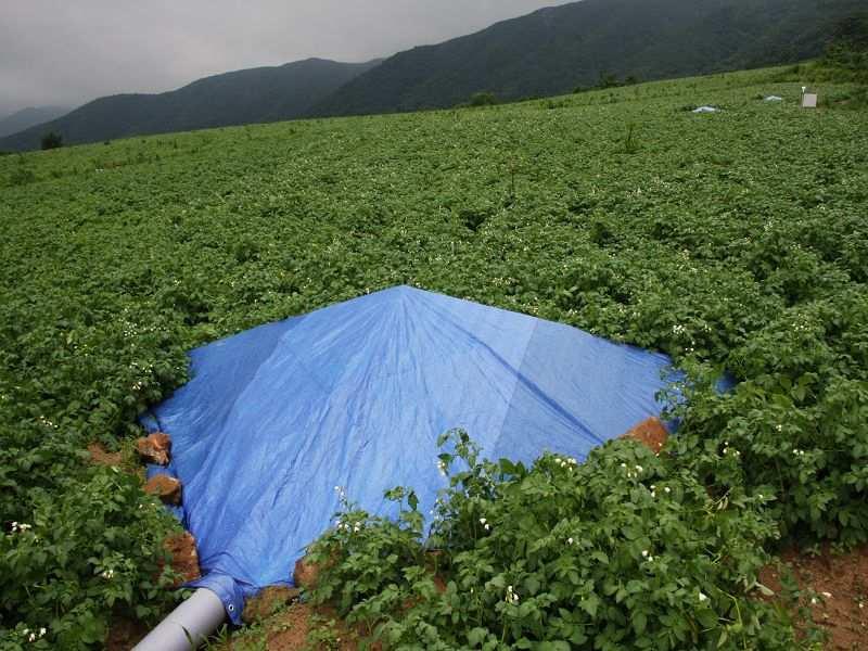
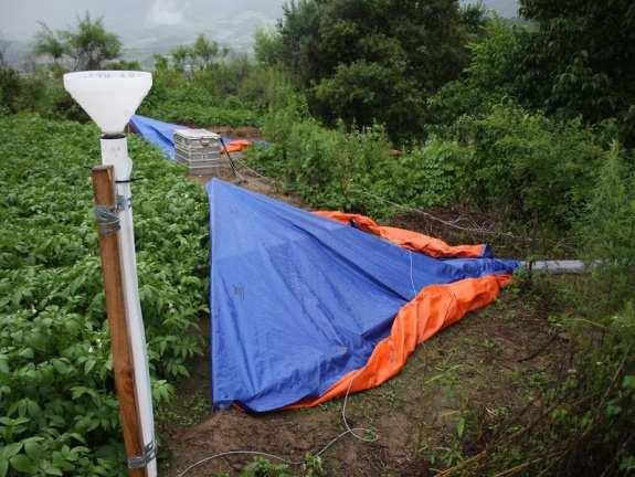
7 Runoff and Erosion Measurement Multislot Flow Divider Runoff Collector Buckets with Divider Crown Runoff Collector Design after Bonilla et al and Flow Divider Design after Pinson et al. 2004

 Field 2: Convex Shape (No")
8 Runoff and Erosion Measurement Typical Dryland Fields on Steep Slopes in the Haean Catchment: Field 1: Concave Shape (Depression in the Center) Field 2: Convex Shape (No Depression)


9 Runoff and Erosion Measurement Runoff Collectors and Flow Dividers on Field 1 and 2


10 Field Topography Analysis Soil Surface Measurement: Tachymeter Source: Bavarian Environmental Agency


11 Field Topography Analysis Field 1 Field 2

12 Runoff and Erosion Measurement Field 1 Total Erosion 3650 kg/ha Field 2 Total Erosion 630 kg/ha
13 Erosion Modeling EROSION 3D: Process-based Soil Erosion Model Simulate the Effect of Landscape Topography on Runoff and Erosion Input Data: Field Site DEMs, Soil and Surface Parameters, Recorded Rainfall Data Scenario Simulation: 1. Ridges with Plastic 2. Ridges without Cover 3. Plane Surface

14 Erosion Modeling Model Calibration: Infiltration Capacity and Soil Erodibility Observed vs. Simulated: Field 1 Field 2
15 Erosion Modeling Field 1 Total Erosion 4180 kg/ha 2470 kg/ha 1020 kg/ha Field 2 Total Erosion 550 kg/ha 370 kg/ha 470 kg/ha


16 Erosion Modeling Ridges with Plastic Rill Erosion Across Ridges on Field 1 Ridges without Cover Plane Surface


17 Erosion Modeling Ridges with Plastic Ridges without Cover Plane Surface
18 Conclusions Case Study: Only 2 Field Sites, Only 1 Month of the Korean Monsoon Limitation of Modeling at Field Scale: Rill Erosion Processes, Surface Development No Extrapolation and General Conclusions at this Point Importance of Landscape Topography: Landscape Topography Controls the Effect of Ridge Cultivation on Soil Erosion Topography is a Key Factor for Evaluating Management Strategies in Complex Terrain
 Korea Science and Engineering Foundation")
19 Acknowledgement: German Research Foundation (DFG) Korea Science and Engineering Foundation (KOSEF)

20 Thank You!!! Sebastian Arnhold Department of Soil Physics University of Bayreuth Universitaetsstrasse Bayreuth Germany sebastian.arnhold
Christopher L. Shope, Svenja Bartsch, Marianne Ruidisch, Sebastian Arnhold 6 August International SWAT Conference Ilsan, South Korea
 Tractors, Rice, and Mountains: Hydrogeochemistry in Monsoonal South Korea Christopher L. Shope, Svenja Bartsch, Marianne Ruidisch, Sebastian Arnhold 6 August 2010 2010 International SWAT Conference Ilsan,
Intra-Annual Variations in Temperature Lapse Rate Within a Mountainous Basin in Korea A Case Study of the Punch Bowl, Yanggu
 Intra-Annual Variations in Temperature Lapse Rate Within a Mountainous Basin in Korea A Case Study of the Punch Bowl, Yanggu Choi, Gwangyong (1); Lee, Bora (2); Tenhunen, John (2); Kang, Sinkyu (3) (1)
Watershed Processes and Modeling
 Watershed Processes and Modeling Pierre Y. Julien Hyeonsik Kim Department of Civil Engineering Colorado State University Fort Collins, Colorado Kuala Lumpur - May Objectives Brief overview of Watershed
DEM-based Ecological Rainfall-Runoff Modelling in. Mountainous Area of Hong Kong
 DEM-based Ecological Rainfall-Runoff Modelling in Mountainous Area of Hong Kong Qiming Zhou 1,2, Junyi Huang 1* 1 Department of Geography and Centre for Geo-computation Studies, Hong Kong Baptist University,
Potential Impacts of Climate Change on Soil Erosion Vulnerability Across the Conterminous U.S.
 Potential Impacts of Climate Change on Soil Erosion Vulnerability Across the Conterminous U.S. Catalina Segura 1, Ge Sun 2, Steve McNulty 2, and Yang Zhang 1 1 2 1 Soil Erosion Natural process by which
Organizing Inter- and Transdisciplinary Research in TERRECO TERRECO Seminar, Winter term 2009/10
 Organizing Inter- and Transdisciplinary Research in TERRECO TERRECO Seminar, Winter term 2009/10 Prof. Dr. Thomas Köllner Professorship of Ecological Services (PES), University of Bayreuth Goals 1. Learn
Soil Erosion Calculation using Remote Sensing and GIS in Río Grande de Arecibo Watershed, Puerto Rico
 Soil Erosion Calculation using Remote Sensing and GIS in Río Grande de Arecibo Watershed, Puerto Rico Alejandra M. Rojas González Department of Civil Engineering University of Puerto Rico at Mayaguez.
Regionalization Methods for Watershed Management - Hydrology and Soil Erosion from Point to Regional Scales
 This paper was peer-reviewed for scientific content. Pages 1062-1067. In: D.E. Stott, R.H. Mohtar and G.C. Steinhardt (eds). 2001. Sustaining the Global Farm. Selected papers from the 10th International
AN ASSESSMENT OF THE IMPACT OF RETENTION PONDS
 AN ASSESSMENT OF THE IMPACT OF RETENTION PONDS FOR SEDIMENT TRAPPING IN THE ADA CREEK AND LONGWOOD COVE USING REMOTELY SENSED DATA AND GIS ANALYSIS Sudhanshu Sekhar Panda Associate Professor, GIS/Env.
Geog Lecture 19
 Geog 1000 - Lecture 19 Fluvial Geomorphology and River Systems http://scholar.ulethbridge.ca/chasmer/classes/ Today s Lecture (Pgs 346 355) 1. What is Fluvial Geomorphology? 2. Hydrology and the Water
Drainage Basin Geomorphology. Nick Odoni s Slope Profile Model
 Drainage Basin Geomorphology Nick Odoni s Slope Profile Model Odoni s Slope Profile Model This model is based on solving the mass balance (sediment budget) equation for a hillslope profile This is achieved
CLIMATE RESILIENT ALTITUDINAL GRADIENTS (CRAGs)
") CLIMATE RESILIENT ALTITUDINAL GRADIENTS (CRAGs) BUILDING CLIMATE CHANGE RESILIENCE IN THE KIVU- RUSIZI WATERSHEDS Great Lake Conference Entebbe 2017 Chris Magero WHAT ARE CRAGs? Climate-Resilient Altitudinal
CLIMATE RESILIENT ALTITUDINAL GRADIENTS (CRAGs) BUILDING CLIMATE CHANGE RESILIENCE IN THE KIVU- RUSIZI WATERSHEDS Great Lake Conference Entebbe 2017 Chris Magero WHAT ARE CRAGs? Climate-Resilient Altitudinal
A Spatial Decision Support System for Agriculture and Natural Resources Management in China
 9 th APGEOSS Symposium Xiangzheng Deng A Spatial Decision Support System for Agriculture and Natural Resources Management in China Need to take decisions and make critical day-to-day and long-term planning
Fresh Water: Streams, Lakes Groundwater & Wetlands
 Fresh Water:, Lakes Groundwater & Wetlands Oct 27 Glaciers and Ice Ages Chp 13 Nov 3 Deserts and Wind and EXAM #3 Slope hydrologic cycle P = precip I = precip intercepted by veg ET = evapotranspiration
Gully erosion in winter crops: a case study from Bragança area, NE Portugal
 Gully erosion in winter crops: a case study from Bragança area, NE Portugal T. de Figueiredo Instituto Politécnico de Bragança (IPB/ESAB), CIMO Mountain Research Centre, Bragança, Portugal Foreword This
CHAPTER 2 LITERATURE REVIEW
 7 CHAPTER 2 LITERATURE REVIEW A broad understanding of various topics in environmental science and modeling technology was required to complete the studies presented in this thesis, and it is important
Data Collection and GIS Applications
 Data Collection and GIS Applications Governor s s Conference on the Management of the Illinois River System Jeff Jack of all Trades Boeckler, IDNR Introduction Collecting available GIS data sets Creating
LI Yong (1,2), FRIELINGHAUS Monika (1), BORK Hans-Rudolf (1), WU Shuxia (2), ZHU Yongyi (2)
, FRIELINGHAUS Monika (1), BORK Hans-Rudolf (1), WU Shuxia (2), ZHU Yongyi (2)") Scientific registration n : Symposium n : 31 Presentation : poster Spatial patterns of soil redistribution and sediment delivery in hilly landscapes of the Loess Plateau Motifs spaciaux de zones d'érosion
Scientific registration n : Symposium n : 31 Presentation : poster Spatial patterns of soil redistribution and sediment delivery in hilly landscapes of the Loess Plateau Motifs spaciaux de zones d'érosion
Hydrologic Modelling of the Upper Malaprabha Catchment using ArcView SWAT
 Hydrologic Modelling of the Upper Malaprabha Catchment using ArcView SWAT Technical briefs are short summaries of the models used in the project aimed at nontechnical readers. The aim of the PES India
SPECIFIC DEGRADATION AND RESERVOIR SEDIMENTATION. By Renee Vandermause & Chun-Yao Yang
 SPECIFIC DEGRADATION AND RESERVOIR SEDIMENTATION By Renee Vandermause & Chun-Yao Yang Outline Sediment Degradation - Erosion vs Sediment Yield - Sediment Yield - Methods for estimation - Defining Sediment
STUDY GUIDE FOR CONTENT MASTERY. Surface Water Movement
 Surface Water SECTION 9.1 Surface Water Movement In your textbook, read about surface water and the way in which it moves sediment. Complete each statement. 1. An excessive amount of water flowing downslope
Development of a GIS Interface for WEPP Model Application to Great Lakes Forested Watersheds
 Development of a GIS Interface for WEPP Model Application to Great Lakes Forested Watersheds J.R. Frankenberger 1, S. Dun 2, D.C. Flanagan 1, J.Q. Wu 2, W.J. Elliot 3 1 USDA-ARS, West Lafayette, IN 2 Washington
Erosion Surface Water. moving, transporting, and depositing sediment.
 + Erosion Surface Water moving, transporting, and depositing sediment. + Surface Water 2 Water from rainfall can hit Earth s surface and do a number of things: Slowly soak into the ground: Infiltration
Application of an Enhanced, Fine-Scale SWAT Model to Target Land Management Practices for Maximizing Pollutant Reduction and Conservation Benefits
 Application of an Enhanced, Fine-Scale SWAT Model to Target Land Management Practices for Maximizing Pollutant Reduction and Conservation Benefits Amanda Flynn, Todd Redder, Joe DePinto, Derek Schlea Brian
INTRODUCTION TO ARCGIS 10
 Department of Irrigation, Drainage and Landscape Engineering, Faculty of Civil Engineering, CTU Prague Institute of Hydraulics and Rural Water Management BOKU Vienna INTRODUCTION TO ARCGIS 10 MAIN WINDOW
Fluvial Systems Lab Environmental Geology Lab Dr. Johnson
 Fluvial Systems Lab Environmental Geology Lab Dr. Johnson *Introductory sections of this lab were adapted from Pidwirny, M. (2006). "Streamflow and Fluvial Processes". Fundamentals of Physical Geography,
Running Water Earth - Chapter 16 Stan Hatfield Southwestern Illinois College
 Running Water Earth - Chapter 16 Stan Hatfield Southwestern Illinois College Hydrologic Cycle The hydrologic cycle is a summary of the circulation of Earth s water supply. Processes involved in the hydrologic
Bachelor of Biosystems Technology Faculty of Technology South Eastern University of Sri Lanka
 Bachelor of Biosystems Technology Faculty of Technology South Eastern University of Sri Lanka BSE 11042 Principles of Irrigation Furrow Irrigation Running water in small channels (furrows) Water infiltration
Flood Inundation Analysis by Using RRI Model For Chindwin River Basin, Myanmar
 Flood Inundation Analysis by Using RRI Model For Chindwin River Basin, Myanmar Aye Aye Naing Supervisor : Dr. Miho Ohara MEE14625 Dr. Duminda Perera Dr. Yoshihiro Shibuo ABSTRACT Floods occur during the
Susanna Glaze, Bobby Creel, and Christopher Brown New Mexico State University AWRA Spring Specialty Conference 4-6 May 2009 Anchorage, Alaska
 Susanna Glaze, Bobby Creel, and Christopher Brown New Mexico State University 2009 AWRA Spring Specialty Conference 4-6 May 2009 Anchorage, Alaska Outline Introduction to general water resources issues
Review Using the Geographical Information System and Remote Sensing Techniques for Soil Erosion Assessment
 Polish J. of Environ. Stud. Vol. 19, No. 5 (2010), 881-886 Review Using the Geographical Information System and Remote Sensing Techniques for Soil Erosion Assessment Nuket Benzer* Landscape Architecture
Roger Andy Gaines, Research Civil Engineer, PhD, P.E.
 Roger Andy Gaines, Research Civil Engineer, PhD, P.E. Research Civil Engineer/Regional Technical Specialist Memphis District August 24, 2010 Objectives Where we have been (recap of situation and what s
Module/Unit: Landforms Grade Level: Fifth
 Module/Unit: Landforms Grade Level: Fifth PA Academic Standards for Science and Technology and Environment and Ecology: 3.1.7.B Describe the use of models as an application or scientific or technological
Application of SWAT Model to Estimate the Runoff and Sediment Load from the Right Bank Valleys of Mosul Dam Reservoir
 Application of SWAT Model to Estimate the Runoff and Sediment Load from the Right Bank Valleys of Mosul Dam Reservoir Dr Mohammad Ezeel Deen Prof. Nadhir Al-Ansari Prof Sven Knutsson Figure 1.Map of Iraq
HYDRAULIC MODELING OF SOIL ERORION
 18-21 August 28, Daejeon, Korea HYDRAULIC MODELING OF SOIL ERORION Liu Qing-quan Institute of Mechanics, Chinese Academy of Sciences, Beijing 18, China. Email: qqliu@imech.ac.cn ABSTRACT: The prediction
Soil Erosion and Sedimentation
 Soil Erosion and Sedimentation Geologic and accelerated erosion -- Erosion is a natural process : stream development, landscape lowering -- Geologic erosion rates vary with climate, but usually low (
Mountain Rivers. Gutta cavat lapidem. (Dripping water hollows out a stone) -Ovid, Epistulae Ex Ponto, Book 3, no. 10, 1. 5
 -Ovid, Epistulae Ex Ponto, Book 3, no. 10, 1. 5") Mountain Rivers Gutta cavat lapidem (Dripping water hollows out a stone) -Ovid, Epistulae Ex Ponto, Book 3, no. 10, 1. 5 Mountain Rivers Fixed channel boundaries (bedrock banks and bed) High transport
Mountain Rivers Gutta cavat lapidem (Dripping water hollows out a stone) -Ovid, Epistulae Ex Ponto, Book 3, no. 10, 1. 5 Mountain Rivers Fixed channel boundaries (bedrock banks and bed) High transport
SESSION 6: FLUVIAL LANDFORMS
 SESSION 6: FLUVIAL LANDFORMS KEY CONCEPTS: Fluvial Landforms Management of River Catchment Areas Slope Elements X-PLANATION: FLUVIAL LANDFORMS Rivers form landforms as they erode the landscape. These landforms
Sediment- yield estimation, by M-PSIAC method in a GIS environment, case study:jonaghn river sub basin(karun basin)
") Sediment- yield estimation, by M-PSIAC method in a GIS environment, case study:jonaghn river sub basin(karun basin) Yavari-shahla *,Khdabakhsh-Saeed,Mohseni-Hasan, Rezai- Khalil Corresponding author: a
Sediment- yield estimation, by M-PSIAC method in a GIS environment, case study:jonaghn river sub basin(karun basin) Yavari-shahla *,Khdabakhsh-Saeed,Mohseni-Hasan, Rezai- Khalil Corresponding author: a
A probabilistic approach to modeling postfire erosion after the 2009 Australian bushfires
 18 th World IMACS / MODSIM Congress, Cairns, Australia 13-17 July 2009 http://mssanz.org.au/modsim09 A probabilistic approach to modeling postfire erosion after the 2009 Australian bushfires P.R. Robichaud
EARTH S CHANGING SURFACE
 EARTH S CHANGING SURFACE Weathering Together, weathering and erosion work continuously to wear down the material on Earth s surface. weathering process that breaks down rock and other substances of Earth
Floodplain modeling. Ovidius University of Constanta (P4) Romania & Technological Educational Institute of Serres, Greece
 Romania & Technological Educational Institute of Serres, Greece") Floodplain modeling Ovidius University of Constanta (P4) Romania & Technological Educational Institute of Serres, Greece Scientific Staff: Dr Carmen Maftei, Professor, Civil Engineering Dept. Dr Konstantinos
Floodplain modeling Ovidius University of Constanta (P4) Romania & Technological Educational Institute of Serres, Greece Scientific Staff: Dr Carmen Maftei, Professor, Civil Engineering Dept. Dr Konstantinos
13 Watershed Delineation & Modeling
 Module 4 (L12 - L18): Watershed Modeling Standard modeling approaches and classifications, system concept for watershed modeling, overall description of different hydrologic processes, modeling of rainfall,
Hillslope Erosion Rates in the Oak Savannas of the Southwestern Borderlands Region
 Hillslope Erosion Rates in the Oak Savannas of the Southwestern Borderlands Region Item type Authors Publisher Journal Rights text; Proceedings Kauffman, Arron T.; Stropki, Cody L.; Ffolliott, Peter F.;
Assessment of solid load and siltation potential of dams reservoirs in the High Atlas of Marrakech (Moorcco) using SWAT Model
 using SWAT Model") Assessment of solid load and siltation potential of dams reservoirs in the High Atlas of Marrakech (Moorcco) using SWAT Model Amal Markhi: Phd Student Supervisor: Pr :N.Laftrouhi Contextualization Facing
Assessment of solid load and siltation potential of dams reservoirs in the High Atlas of Marrakech (Moorcco) using SWAT Model Amal Markhi: Phd Student Supervisor: Pr :N.Laftrouhi Contextualization Facing
Basin characteristics
 Basin characteristics From hydrological processes at the point scale to hydrological processes throughout the space continuum: point scale à river basin The watershed characteristics (shape, length, topography,
Modeling soil erosion by water on agricultural land in Cenei, Timiş County, Romania
 Modeling soil erosion by water on agricultural land in Cenei, Timiş County, Romania GEORGE NARCIS PELEA, IOANA ALINA COSTESCU, ERIKA BEILICCI, TEODOR EUGEN MAN, ROBERT BEILICCI Faculty of Civil Engineering,
Erosion and Sedimentation Basics
 Erosion and Sedimentation Basics Coastal San Luis Resource Conservation District G.W. Bates, PE, CPESC Outline: 1. Terms & Concepts 2. Causes of Erosion 3. The Erosion/Sedimentation Process 4. Erosion
Using 7Be to Trace Temporal Variation of Interrill and Rill Erosion on Slopes
 Available online at www.sciencedirect.com Procedia Environmental Sciences 11 (2011) 1220 1226 Using 7Be to Trace Temporal Variation of Interrill and Rill Erosion on Slopes Gang Liu 1, Qiong Zhang 3, Mingyi
Watershed Application of WEPP and Geospatial Interfaces. Dennis C. Flanagan
 Watershed Application of WEPP and Geospatial Interfaces Dennis C. Flanagan Research Agricultural Engineer USDA-Agricultural Research Service Adjunct Professor Purdue Univ., Dept. of Agric. & Biol. Eng.
EVALUATION OF MIGRATION OF HEAVY METAL CONTAINING SEDIMENT RESULTING FROM WATER EROSION USING A GEO- INFORMATION MODEL
 EVALUATION OF MIGRATION OF HEAVY METAL CONTAINING SEDIMENT RESULTING FROM WATER EROSION USING A GEO- INFORMATION MODEL János Tamás, Elza Kovács University of Debrecen, Centre of Agricultural Sciences Department
Use of SWAT to Scale Sediment Delivery from Field to Watershed in an Agricultural Landscape with Depressions
 Use of SWAT to Scale Sediment Delivery from Field to Watershed in an Agricultural Landscape with Depressions James E. Almendinger St. Croix Watershed Research Station, Science Museum of Minnesota Marylee
Module 4: Overview of the Fundamentals of Runoff and Erosion
 Module 4: Overview of the Fundamentals of Runoff and Erosion Module 4a Goal Once we can better understand the forces which cause erosion and runoff, only then can we begin to minimize the negative results.
Sediment loads and erosion in forest headwater streams of the Sierra Nevada, California
 Revisiting Experimental Catchment Studies in Forest Hydrology (Proceedings of a Workshop held during the XXV IUGG General Assembly in Melbourne, June July 2011) (IAHS Publ. 353, 2012). 195 Sediment loads
KINEROS2/AGWA. Fig. 1. Schematic view (Woolhiser et al., 1990).
.") KINEROS2/AGWA Introduction Kineros2 (KINematic runoff and EROSion) (K2) model was originated at the USDA-ARS in late 1960s and released until 1990 (Smith et al., 1995; Woolhiser et al., 1990). The spatial
KINEROS2/AGWA Introduction Kineros2 (KINematic runoff and EROSion) (K2) model was originated at the USDA-ARS in late 1960s and released until 1990 (Smith et al., 1995; Woolhiser et al., 1990). The spatial
A Systems-Approach Model for Conservation Planning of a Hilly Watershed
 A Systems-Approach Model for Conservation Planning of a Hilly Watershed J. Adinarayana 1. Abstract Centre of Studies in Resources Engineering Indian Institute of Technology, Bombay Powai, Mumbai - 400
What is a Glacier? Types of Glaciers
 Alpine & Continental Glaciers Glacial Mass Balance Glacial Ice Formation Glacial Movement & Erosion Erosional and Depositional Landforms The Pleistocene Epoch Geomorphology of SW Manitoba Chapter 17 1
Analysis on the Runoff and Sediment Yielding of 7.26 Rainstorm in 2017 in the Dali River Basin
 Analysis on the Runoff and Sediment Yielding of 7.26 Rainstorm in 217 in the Dali River Basin WenYong Gao, ShuangYan Jin and ShaoMeng Guo (Yellow River Institute of Hydrology and Water Resources, Zhengzhou
Earth Science Physical Setting Relationship Review Sketch all graphs in pencil For a uniform material. Density. Average Temperature
 except water Water For a uniform material Volume For a uniform material Volume (cm3) 0 4 10 Volume (cm3) ( C) 0 4 5 90 0 4 5 90 Distance Between Isolines Latitude ( N) Latitude ( N) Number of Isolines
Impact of Dam and Weirs on Cross-Sectional Characteristics of Urmodi Channel, Maharashtra: An Approach to Geoinformatics
 Impact of Dam and Weirs on Cross-Sectional Characteristics of Urmodi Channel, Maharashtra: An Approach to Geoinformatics Sarika B. Suryawanshi, Jagdish B. Sapkale, Vidya A. Chougule Abstract Dams and reservoirs
Building the Climate Change Resilience in the Lake Kivu and Rusizi River Catchments: CRAGs II project
 Building the Climate Change Resilience in the Lake Kivu and Rusizi River Catchments: CRAGs II project Project countries: Rwanda and Burundi Project Area: Sebeya and Ruhwa River Systems (Rwanda), Muhira
Date of Report: EPA agreement number: Center Name and Institution of Ctr. Director: Identifier used by Center for Project: Title of Project:
 Date of Report: March 31, 2003 EPA agreement number: R829515C003 Center Name and Institution of Ctr. Director: Rocky Mountain Regional Hazardous Substance Research Center, Colorado State University, Fort
Watershed Development Prioritization by Applying WERM Model and GIS Techniques in Takoli Watershed of District Tehri (Uttarakhand)
") Watershed Development Prioritization by Applying WERM Model and GIS Techniques in Takoli Watershed of District Tehri (Uttarakhand) Anju Panwar Uttarakhand Space Application Centre Dehradun, Uttarkhand
Watershed Development Prioritization by Applying WERM Model and GIS Techniques in Takoli Watershed of District Tehri (Uttarakhand) Anju Panwar Uttarakhand Space Application Centre Dehradun, Uttarkhand
Subject Name: SOIL AND WATER CONSERVATION ENGINEERING 3(2+1) COURSE OUTLINE
 COURSE OUTLINE") Subject Name: SOIL AND WATER CONSERVATION ENGINEERING 3(2+1) COURSE OUTLINE (Name of Course Developer: Prof. Ashok Mishra, AgFE Department, IIT Kharagpur, Kharagpur 721 302) Module 1: Introduction and
Subject Name: SOIL AND WATER CONSERVATION ENGINEERING 3(2+1) COURSE OUTLINE (Name of Course Developer: Prof. Ashok Mishra, AgFE Department, IIT Kharagpur, Kharagpur 721 302) Module 1: Introduction and
Estimation of sediment yield using Remote Sensing (RS) and Geographic Information System (GIS) technique
 and Geographic Information System (GIS) technique") Serials Publications Estimation of sediment yield using Remote Sensing (RS)... National Academy of Agricultural Science (NAAS) Rating : 3. 03 Estimation of sediment yield using Remote Sensing (RS) and
Serials Publications Estimation of sediment yield using Remote Sensing (RS)... National Academy of Agricultural Science (NAAS) Rating : 3. 03 Estimation of sediment yield using Remote Sensing (RS) and
SAVE. content packet
 SAVE content packet Erosion & Weathering key terms Deposition Sediment Soil Particulates Runoff Weathering Mechanical Weathering Chemical Weathering background information The Earth is constantly changing.
GIS model & modeling
 GIS model & modeling Model : a simplified representation of a phenomenon or a system. GIS modeling : the use of GIS in the process of building models with spatial data. Basic requirement in modeling :
The Importance of Snowmelt Runoff Modeling for Sustainable Development and Disaster Prevention
 The Importance of Snowmelt Runoff Modeling for Sustainable Development and Disaster Prevention Muzafar Malikov Space Research Centre Academy of Sciences Republic of Uzbekistan Water H 2 O Gas - Water Vapor
Track design and management
 1 Track design and management Peter Fogarty, Certified Professional Soil Scientist NSW Soil Knowledge Network Cooma, June 18, 2018 Acknowledgements Antia Brademann, Cooma Waterwatch, Organiser Jo Powells,
Sediment exports from French rivers. Magalie Delmas, Olivier Cerdan, Jean-Marie Mouchel*, Frédérique Eyrolles, Bruno Cheviron
 Sediment exports from French rivers Magalie Delmas, Olivier Cerdan, Jean-Marie Mouchel*, Frédérique Eyrolles, Bruno Cheviron Université Pierre et Marie Curie, Paris BRGM, Orléans ISRN, Cadarache Study
Linking local multimedia models in a spatially-distributed system
 Linking local multimedia models in a spatially-distributed system I. Miller, S. Knopf & R. Kossik The GoldSim Technology Group, USA Abstract The development of spatially-distributed multimedia models has
EROSION CONTROL FIELD GUIDE By Craig Sponholtz & Avery C. Anderson
 WORKING WITH NATURE TO HEAL EROSION Soil loss caused by flowing water diminishes the fertility, productivity and healing capacity of the land. This guide was created to empower landowners and managers
Watershed concepts for community environmental planning
 Purpose and Objectives Watershed concepts for community environmental planning Dale Bruns, Wilkes University USDA Rural GIS Consortium May 2007 Provide background on basic concepts in watershed, stream,
Each basin is surrounded & defined by a drainage divide (high point from which water flows away) Channel initiation
 Channel initiation") DRAINAGE BASINS A drainage basin or watershed is defined from a downstream point, working upstream, to include all of the hillslope & channel areas which drain to that point Each basin is surrounded &
DRAINAGE BASINS A drainage basin or watershed is defined from a downstream point, working upstream, to include all of the hillslope & channel areas which drain to that point Each basin is surrounded &
Michael Barton School of Human Evolution & Social Change Center for Social Dynamics & Complexity
 Michael Barton School of Human Evolution & Social Change Center for Social Dynamics & Complexity Social Systems are Complex Even simple social systems are complex Complexity has grown at increasing rate
Randy B. Foltz and William J. Elliot 1
 Measuring and Modeling Impacts of Tire Pressure on Road Erosion Randy B. Foltz and William J. Elliot 1 Abstract The sediment production from highway tire pressures, constant reduced tire pressures, and
Governing Rules of Water Movement
 Governing Rules of Water Movement Like all physical processes, the flow of water always occurs across some form of energy gradient from high to low e.g., a topographic (slope) gradient from high to low
Continuing Education Associated with Maintaining CPESC and CESSWI Certification
 Continuing Education Associated with Maintaining CPESC and CESSWI Certification Module 2: Stormwater Management Principles for Earth Disturbing Activities Sponsors: ODOTs Local Technical Assistance Program
Eagle Creek Post Fire Erosion Hazard Analysis Using the WEPP Model. John Rogers & Lauren McKinney
 Eagle Creek Post Fire Erosion Hazard Analysis Using the WEPP Model John Rogers & Lauren McKinney Columbia River Gorge at Risk: Using LiDAR and GIS-based predictive modeling for regional-scale erosion susceptibility
Creating Watersheds and Stream Networks. Steve Kopp
 Creating Watersheds and Stream Networks Steve Kopp Workshop Overview Demo Data Understanding the tools Elevation Data Types DEM : Digital Elevation Model bare Earth DSM : Digital Surface Model Data Structure
Using Morphometric models and Open Source Software to locate Flood prone areas A guide to pilot Implementation
 SciNetNatHaz Project Progress Meeting - 23-26 Oct 2014, Burgas, Bulgaria SciNetNatHaz Project Progress Meeting - 7-9 May 2015, Thessaloniki, Hellas Using Morphometric models and Open Source Software to
Dr. S.SURIYA. Assistant professor. Department of Civil Engineering. B. S. Abdur Rahman University. Chennai
 Hydrograph simulation for a rural watershed using SCS curve number and Geographic Information System Dr. S.SURIYA Assistant professor Department of Civil Engineering B. S. Abdur Rahman University Chennai
INTERNATIONAL JOURNAL OF GEOMATICS AND GEOSCIENCES Volume 4, No 2, 2013
 INTERNATIONAL JOURNAL OF GEOMATICS AND GEOSCIENCES Volume 4, No 2, 2013 Copyright 2010 All rights reserved Integrated Publishing services Research article ISSN 0976 4380 Evaluation of landuse / landcover
Gully Erosion Part 1 GULLY EROSION AND ITS CAUSES. Introduction. The mechanics of gully erosion
 Gully Erosion Part 1 GULLY EROSION AND ITS CAUSES Gully erosion A complex of processes whereby the removal of soil is characterised by incised channels in the landscape. NSW Soil Conservation Service,
arxiv: v2 [physics.geo-ph] 16 Jan 2017
![arxiv: v2 [physics.geo-ph] 16 Jan 2017](/thumbs/80/80699670.jpg "arxiv: v2 [physics.geo-ph] 16 Jan 2017") Commentary Commentary on Modified MMF (Morgan Morgan Finney) model for evaluating effects of crops and vegetation cover on soil erosion by Morgan and Duzant (2008) arxiv:62.08899v2 [physics.geo-ph] 6 Jan
Commentary Commentary on Modified MMF (Morgan Morgan Finney) model for evaluating effects of crops and vegetation cover on soil erosion by Morgan and Duzant (2008) arxiv:62.08899v2 [physics.geo-ph] 6 Jan
Conservation Planning evaluate land management alternatives to reduce soil erosion to acceptable levels. Resource Inventories estimate current and
 Conservation Planning evaluate land management alternatives to reduce soil erosion to acceptable levels. Resource Inventories estimate current and projected erosion levels and their impact on natural resource
mountain rivers fixed channel boundaries (bedrock banks and bed) high transport capacity low storage input output
 high transport capacity low storage input output") mountain rivers fixed channel boundaries (bedrock banks and bed) high transport capacity low storage input output strong interaction between streams & hillslopes Sediment Budgets for Mountain Rivers Little
mountain rivers fixed channel boundaries (bedrock banks and bed) high transport capacity low storage input output strong interaction between streams & hillslopes Sediment Budgets for Mountain Rivers Little
Relating Crop Yields to Physiographic Attributes in Ohio Through Principal Component Analysis
 This paper was peer-reviewed for scientific content. Pages 7-76. In: D.E. tott, R.H. Mohtar and G.. teinhardt (eds). 00. ustaining the Global Farm. elected papers from the 0th International oil onservation
MODULE 7 LECTURE NOTES 5 DRAINAGE PATTERN AND CATCHMENT AREA DELINEATION
 MODULE 7 LECTURE NOTES 5 DRAINAGE PATTERN AND CATCHMENT AREA DELINEATION 1. Introduction Topography of the river basin plays an important role in hydrologic modelling, by providing information on different
VILLAGE INFORMATION SYSTEM (V.I.S) FOR WATERSHED MANAGEMENT IN THE NORTH AHMADNAGAR DISTRICT, MAHARASHTRA
 FOR WATERSHED MANAGEMENT IN THE NORTH AHMADNAGAR DISTRICT, MAHARASHTRA") VILLAGE INFORMATION SYSTEM (V.I.S) FOR WATERSHED MANAGEMENT IN THE NORTH AHMADNAGAR DISTRICT, MAHARASHTRA Abstract: The drought prone zone in the Western Maharashtra is not in position to achieve the agricultural
VILLAGE INFORMATION SYSTEM (V.I.S) FOR WATERSHED MANAGEMENT IN THE NORTH AHMADNAGAR DISTRICT, MAHARASHTRA Abstract: The drought prone zone in the Western Maharashtra is not in position to achieve the agricultural
RANGE AND ANIMAL SCIENCES AND RESOURCES MANAGEMENT - Vol. II - Catchment Management A Framework for Managing Rangelands - Hugh Milner
 CATCHMENT MANAGEMENT A FRAMEWORK FOR MANAGING RANGELANDS Hugh Milner International Water Management Consultant, Australia Keywords: Rangeland management; catchments and watersheds; catchment management
Application of USLE Model & GIS in Estimation of Soil Erosion for Tandula Reservoir
 Application of USLE Model & GIS in Estimation of Soil Erosion for Tandula Reservoir Ishtiyaq Ahmad 1, Dr. M. K. Verma 2 1 Ph.D. Research Scholar, Dept. of Civil Engg. NIT Raipur (C.G.) - India 2 Prof.
AREAL MODELING OF EROSION FOR ENVIRONMENTAL NONPOINT APPLICATIONS (AMEENA)
") AREAL MODELING OF EROSION FOR ENVIRONMENTAL NONPOINT APPLICATIONS (AMEENA) Mohammad Ahmed Al-Smadi Dissertation submitted to the Faculty of Virginia Polytechnic Institute and State University in partial
AREAL MODELING OF EROSION FOR ENVIRONMENTAL NONPOINT APPLICATIONS (AMEENA) Mohammad Ahmed Al-Smadi Dissertation submitted to the Faculty of Virginia Polytechnic Institute and State University in partial
CHAPTER VII FULLY DISTRIBUTED RAINFALL-RUNOFF MODEL USING GIS
 80 CHAPTER VII FULLY DISTRIBUTED RAINFALL-RUNOFF MODEL USING GIS 7.1GENERAL This chapter is discussed in six parts. Introduction to Runoff estimation using fully Distributed model is discussed in first
***When doing the lab report write-up, be sure to follow the guidelines.***
 Topographic Maps Lab Vocabulary: topography - study of the shapes and features of the earth's surface elevation - height above sea level bench mark - a point that has been accurately measured for its position
PREDICTING BACKGROUND AND RISK-BASED SEDIMENTATION FOR FOREST WATERSHED TMDLS
 This is not a peer-reviewed article. Watershed Management to Meet Water Quality Standards and TMDLS (Total Maximum Daily Load) Proceedings of the Fourth Conference 10-14 March 2007 (San Antonio, Texas
Effects of forest cover and environmental variables on snow accumulation and melt
 Effects of forest cover and environmental variables on snow accumulation and melt Mariana Dobre, William J. Elliot, Joan Q. Wu, Timothy E. Link, Ina S. Miller Abstract The goal of this study was to assess
Modeling of a River Basin Using SWAT Model and SUFI-2
 Modeling of a River Basin Using SWAT Model and SUFI-2 NINA OMANI MASOUD TAJRISHY AHMAD ABRISHAMCHI Sharif University of Technology, Tehran, Iran Karkheh Dam, Iran 1 Area of Gharasu Sub-basin : 5793 km2
Erosion Risk Management Tool (ERMiT) User Manual
 User Manual") United States Department of Agriculture Forest Service Rocky Mountain Research Station General Technical Report RMRS-GTR-188 April 2007 Erosion Risk Management Tool (ERMiT) User Manual (version 2006.01.18)
United States Department of Agriculture Forest Service Rocky Mountain Research Station General Technical Report RMRS-GTR-188 April 2007 Erosion Risk Management Tool (ERMiT) User Manual (version 2006.01.18)
8 Current Issues and Research on Sediment Movement in the River Catchments of Japan
 8 Current Issues and Research on Sediment Movement in the River Catchments of Japan YUTAKA ICHIKAWA INTRODUCTION Prediction of sediment movement is one of the challenging tasks in water-related research.