Estimation of Seismic Hazard Using PSHA in and around National Capital Region (NCR) of India
|
|
|
- Jesse Bishop
- 6 years ago
- Views:
Transcription
1 Geosciences 2017, 7(4): DOI: /j.geo Estimation of Seismic Hazard Using PSHA in and around National Capital Region (NCR) of India S. Sarkar, D. Shanker * Department of Earthquake Engineering, Indian Institute of Technology Roorkee, Roorkee, India Abstract The National Capital Region (NCR) of India is situated on top of some active faults with moderate level of seismicity which makes it an earthquake prone city. Further the dense population and large number of engineering structures in the area, make it vulnerable to earthquake hazard. It is very imperative to design the buildings and other engineering structures in this region only after assessing the seismic hazard so that loss of life and property damage may reduce. For this, earthquake catalogue is prepared using different available earthquake reporting agencies for National Capital Region (NCR) region and then Probabilistic Seismic Hazard Assessment is carried out for NCR region using the CRISIS2007 software. Hazard maps are prepared for structures of different time period for both, fixed intensity and fixed return periods. Seismic Hazard Curves and Uniform Hazard Response Spectra are also prepared for various sites in and around the considered region, which will be helpful for earthquake resistant design, risk targeted design and fragility analysis of structures at these sites. Keywords Probabilistic seismic hazard analysis, Attenuation relationships, Seismic hazard curves, The National Capital Region (NCR) 1. Introduction Earthquake is one of the most complex phenomena which we are facing since the beginning of our civilization. Even now it is nearly impossible to predict an earthquake accurately. The much hype around this natural disaster is due to uncountable loss of lives and demolition of structures it has caused. Several statistical and probabilistic models are being developed to estimate the size, time and location of upcoming earthquakes. However, engineers do not care much about the magnitude of an earthquake, which is basically the amount of energy released at the focus, but the ground motion parameters (GMPs) like intensity, peak ground acceleration (PGA), spectral acceleration etc., also now as the hazard parameters. The response of a building, bridge, dam or any other engineering structure to an earthquake depends directly on these ground motion parameters. Several ground motion parameter equations or attenuation relationships are developed by seismologists to estimate the ground motions for a region or site based on several factors like hypo-central distance, site condition, seismicity of the nearby sources etc. Generally, Seismic hazard assessment is carried out for estimating the ground motion exceedance rate in a particular time period. Traditionally, two basic types of seismic hazard assessments * Corresponding author: dayasfeq@iitr.ernet.in (D. Shanker) Published online at Copyright 2017 Scientific & Academic Publishing. All Rights Reserved methodologies are followed: deterministic seismic hazard assessment (DSHA) and probabilistic seismic hazard assessment (PSHA). DSHA is a highly conservative method and is used for the design of structures which can cause severe hazard on collapse like dams, nuclear power plants etc. DSHA is mainly based on a single worst case scenario ground motion consideration. Whereas, PSHA incorporates all types of uncertainties associated with the earthquake location, occurrence, magnitude etc. and is considered economical and less conservative model. PSHA results are widely used for designing any type of structures. In this investigation probabilistic seismic hazard assessment has been carried out for the National Capital Region (NCR) of India. NCR is one of the most densely populated and highly industrialized regions in India. As per IS 1893 (Part: 1) : 2002, most part of NCR including capital region of New Delhi falls under zone IV in the seismic zoning map of India and rest parts in zone III, which makes it important for such types of studies due to its vulnerability to major earthquakes. 2. Study Area The area of study (Fig. 1) comprises of three states Uttar Pradesh, Haryana, Rajasthan and National Capital Territory (NCT) Delhi (Table 1) consists of 23 districts with a total area of around square km. The area is bounded by Karnal in the north, Bhiwani In the west, Bharatpur in the South and Bulandshahr in the east.

2 110 S. Sarkar et al.: Estimation of Seismic Hazard Using PSHA in and around National Capital Region (NCR) of India Table 1. Districts of NCR Districts Latitude ( N ) Longitude ( E) 1. Uttar Pradesh Meerut Muzaffarnagar Shamli Ghaziabad Gautam Budh Nagar Bulandshahr Baghpat Hapur Haryana Gurgaon Mahendragarh Bhiwani Nuh Rohtak Sonipat Rewari Jhajjar Panipat Palwal Jind Karnal Rajasthan Alwar Bharatpur NCT Delhi Seismotectonic Features of NCR The NCR is surrounded by many major lineaments, thrusts and faults. Out of which some are alive (active) and some are not. An active source or fault is one which has shown some movement or seismic activity in the past years. Active faults are more likely responsible to cause the next earthquake in the surrounding region. The NCT Delhi microzonation report published by Indian Meteorological Department in 2014 and a document published by SHARMA and WASON (2004) are utilized as base reference to distinguish and plot the major active sources in the area of study. Finally seven major seismic faults were identified out of which six have been modelled as line source, and one as area source are taken as input parameters for analysis in CRISIS2007. These seismic faults are Great Boundary Fault (GBF), Moradabad Fault, Mathura Fault, Sohna Fault, Delhi-Haridwar Ridge, Mahendragarh-Dehradun Fault (MDF) and the Frontal Folded Zone. Only the Frontal Folded Zone in the Himalayan region is modelled as an area source. Despite being away from the NCR region, the Frontal Folded zone has been considered, because the tremors/major earthquakes caused by this zone are frequently influence the NCR seismic activities, causing structural damage and strong shaking. The locations of the considered active faults are shown in Fig. 1. Figure 1. Seismotectonic map of NCR (containing only the active sources which are used for modeling in CRISIS2007) 4. Earthquake Catalogue The very first step to carry out a seismic hazard analysis of any region is to make suitable earthquake catalogue for that region. An earthquake catalogue gives us information about historical and recent earthquake magnitude, focus (focal depth) and time. Earthquake data for the study area has been extracted from several agencies like United State Geological Survey (USGS), International Seismological Center (ISC), India Meteorological Department (IMD) New Delhi and also several publications like IYENGAR et al., Figure 2. Plot illustrating the moment magnitude of earthquake occurred during in NCR includes main shock, foreshock and aftershock

3 Geosciences 2017, 7(4): While forming the catalogue it is very important that it should be homogeneous i.e. all the magnitude values taken from various sources have the same scale. If the data consists of different magnitude scale, then they are converted to same scale using conversion relationships. This process is known as homogenization of an earthquake catalogue. In this study, I have considered the moment magnitude scale for all computations Catalogue Declustering The earthquake catalogue that is shown in Fig. 2 contains foreshocks and aftershocks along with the main events. Now for seismic hazard analysis only main events are to be considered for any analysis. Hence the foreshocks and aftershocks are to be removed from the catalogue in order to carry any further analysis. Declustering has been done in space and time domain by using the algorithm of REASENBERG (1985); GARDNER and KNOPOFF (1974). Initially the catalogue consisted of 245 events for the time period But after declustering the number of events has reduced to 139 and these events are plotted and shown in (Fig 3). There were 42 foreshocks and 64 aftershocks. the tangent (1/ T) gives the degree of completeness. Figure 4 and Tables 2 & 3 described the results of data treatment for the completeness. Table 2. Number of reported earthquakes in different magnitude ranges in 5 year time period (for completeness analysis) Time M<4 4.1<M< <M<5 5.1<M<5.5 M>5.5 Total Total Table 3. Completeness of earthquake catalogue Figure 3. Seismicity of NCR ( ) after declustering 4.2. Completeness of Catalogue Due to lack of proper instruments and networking in earlier times, many earthquakes data were not recorded. If the degree of incompleteness is very high then the analysis carried out will not give accurate results. Hence it is important to know the degree of completeness of an earthquake catalogue before doing any further analysis. The most famous method to check the completeness of an earthquake catalogue is method described by STEPP (1972). For the considered region the whole dataset were divided into five groups: M<4, 4.1<M<4.5, 4.6<M<5, 5.1<M<5.5, M>5 for the time period i.e. 55 years. We have calculated the average number of events each year in each magnitude group formed above, and then the standard deviation of the mean rate (λ) are calculated for considered sample length. According to Stepp, the deviation of λ form Standard Deviation Magnitude range Complete intervals (years) M< <M< <M< <M< M> TIME (in years) M<4 4<M< <M<5 5.1<M<5.5 M>5.5 1/Sqrt(T) Figure 4. Variation of standard deviation of different magnitude range against time interval and the tangent line 1/ T
4 112 S. Sarkar et al.: Estimation of Seismic Hazard Using PSHA in and around National Capital Region (NCR) of India 5. Seismic Hazard Parameters of NCR Maximum magnitude (M max ), earthquake activity rate (λ) and the b-value (or the β-value) from the Gutenberg-Richter relationship are the three major seismic hazard parameters which are used to define the seismicity of an area or a source governing the earthquake scenario of given region. The most common frequency magnitude distribution proposed by GUTENBERG and RICHTER (1954). Poisson s distribution. This relationship is helpful only if the catalogue we are dealing with has 100% completeness and contains each and every earthquake data for a very large period of time. But this is not possible in actual practice. Hence after several efforts a method was established to deal with the incomplete data files by incorporating magnitude heterogeneity, utilizing the extreme and complete set of catalogue of various threshold magnitudes. Maximum likelihood estimation of the seismic hazard parameters by KIJKO and SELLEVOLL (1989) is commonly used. However, this method could not tell uncertainty in magnitude. KIJKO and SELLEVOLL (1992) again formulated a methodology incorporating the uncertainty of magnitude and a computer program was developed to calculate the hazard parameters. This methodology is widely accepted and used to find the seismic hazard parameters for many regions. In recent years, new approach is presented by MUSSON (2003) which estimates all the three hazard parameters (λ, β and M max ) simultaneously using Monte-Carlo simulation. This method assumes Poisson s model for earthquake occurrence and selects a set of values for the triplet (three hazard parameter) randomly and uses them to make a new synthetic earthquake catalogue using Monte Carlo simulation. This synthetic catalogue is then compared with the originally prepared catalogue for that region. This is an iterative method, goes on until the synthetic catalogue matches with the original catalogue. The seismicity of the Delhi region has been reported several times before, but only limited publications and reports. The Delhi microzonation report by Indian Meteorological Department (2016) has divided NCT Delhi into 4 seismic zones based on the presence of active faults and earthquake occurrences, while several other publications have divided the NCR region into 5 and 6 zones. In this study we have utilized some of the estimates as given in Table 4 (SHARMA and WASON; 2004). 6. Attenuation Relationships When engineers talk about earthquakes and hazards related to it, they don t mean the earthquake magnitude in Richter scale as it merely describes the amount of energy released at the focus but, the value of intensity, spectral acceleration or peak ground acceleration which actually causes the destruction. Hence it is very important to compute the ground motion while doing probabilistic seismic hazard analysis. However, in most of the cases strong ground motions data are not available or recorded. Several empirical equations were made to estimate the ground motions as a function of site conditions, magnitude source to site distance, tectonic features etc. These relationships which are used to compute the ground motion are known as ground motion prediction equation (GMPE). The sites characteristics of NCR can be classified into three major classes: class B, class C and class D. Class B is hard and firm rock where shear velocity ranges m/s. Class C is dense soil and soft rock where shear velocity is m/s. And class D is soft soil with shear velocity m/s. As reported by Indian Meteorological Department, most of the NCR sites are of sandy soil mixed with clay and silt i.e. of class D. Seismic source zone Great boundary fault zone Moradabad fault zone Mean value of activity rate (λ) Table 4. Seismic hazard parameters for NCR β value Variance of β Maximum magnitude (Mmax) Standard deviation of Mmax Threshold magitude MDF zone Mathura Fault zone Sohna Fault zone Delhi Haridwar ridge zone Himalayan zone
 for Peninsular India, SHARMA (1998) for")
 for interface fault location and soft soil site condition. 7.")

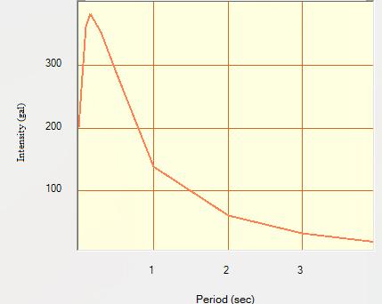
5 Geosciences 2017, 7(4): YOUNGS et al. (1997), ABRAHAMSON and SILVA (1997) and others are few important publications which deals with the attenuation relationships. In India, we do not have ground motion prediction equations for each and every sites but for few seismically active regions (IYENGAR and RAGHUKANTH; 2004) for Peninsular India, SHARMA (1998) for Himalayan region. But no GMPEs are available for NCR. In this study we have mainly used one built-in attenuation model from CRISIS2007, which is YOUNGS et al. (1997) for interface fault location and soft soil site condition. 7. PSHA Using CRISIS2007 Several computer softwares are available for probabilistic seismic hazard assessment like CRISIS2007, SEISRISK III, EQRM, FRISK88M, OpenSHA etc. In this study, the analysis is done using CRISIS2007 due to its flexibility and applicability. Firstly, the map of the study area (NCR) is prepared, along with the existing faults considered to be modelled for the analysis. In general, fault modelling is done as point source, line source or area source. In our case, out of seven faults, six are modelled as line source (Great boundary fault (GBF), Moradabad fault, Mahendragarh-Dehradun fault (MDF), Mathura fault, Sohna fault and Delhi-Haridwar ridge), and the Frontal Folded zone in the Himalaya has been modelled as an area source. The computed seismic hazard parameters for these sources/faults have been estimated and used as input parameters in CRISIS2007 built-in attenuation models assigned to each source/fault as per the site condition of NCR (i.e. soft soil/alluvium soil). Different Ranges of intensity measures (in this case PGA) have been assigned for different structural periods for which the software estimates the hazard values. In this software the intensity is measured in terms of gal unit (1 gal = 0.01m/sec 2 ; 981 gals = 1g or 1g = 9.81m/sec 2 ). Figure 5. Seismic hazard map for fixed return period of 475 years (Design Basis Earthquake) Figure 6. Seismic hazard map for fixed return period of 2475 years (Maximum Considered Earthquake) 8. Results Results obtained from the analysis are presented in three hazard maps prepared in the forms: i) Seismic hazard map for NCR for fixed return periods (475 years for Design basis Earthquake (DBE) as shown in Fig 5 and 2475 years for Maximum Considered Earthquake (MCE) shown in Fig 6. ii) Uniform hazard spectra (UHS) at various sites for a particular return period of 475 years for DBE (Figs 7, 9, 11, 13 and 15). iii) Hazard curve i.e. exceedance rate for intensity/pga for different sites (Figs 8, 10, 12, 14 and 16). Figure 7. UHS for return period 475 years at Connaught place, Delhi

 of India Figure 8.")


6 114 S. Sarkar et al.: Estimation of Seismic Hazard Using PSHA in and around National Capital Region (NCR) of India Figure 8. Hazard curve for intensity at 0 sec at Connaught place, Delhi Figure 11. UHS for return period 475 years at Bhiwani Figure 9. UHS for return period 475 years at Gurgaon Figure 12. Hazard curve for intensity at 0 sec at Bhiwani Figure 10. Hazard curve for intensity at 0 sec at Gurgaon Figure 13. UHS for return period 475 years at Alwar
 and seismic hazard curves (Figs 7-16) it is advocated that the eastern part of the National Capital Region (NCR) has the highest")


7 Geosciences 2017, 7(4): Figure 14. Hazard curve for intensity at 0 sec at Alwar 9. Conclusions From the results of the seismic hazard maps (Figs 5 & 6) and seismic hazard curves (Figs 7-16) it is advocated that the eastern part of the National Capital Region (NCR) has the highest value of seismic hazard. However, the ground motion parameters (PGA and spectral acceleration) decrease from south eastern region to western region. Spectral accelerations have maximum values for period ranging between sec. Hence while designing buildings or any engineering structure in the eastern zone which is the most vulnerable area, the designer should take care for the time period of the structure to minimize the damaging effect of earthquake. If the time periods of the structures match with the time periods of ground motion at that site, resonance will occur and structures will suffer maximum damage. Further, in construction industries, other design aspects like design lives of a structure are also be based on the rate of exceedance of PGA obtained for various sites. So, the Risk targeted design of structures can be utilized in this region where the range of earthquake moment magnitudes is 4 to 5. In this case, designer should do the fragility analysis of a structure based on the seismic hazard curves obtained from PSHA of that particular site. This design method will not only reduce the probability of hazard level but also proved economical. ACKNOWLEDGEMENTS Figure 15. UHS for return period 475 years at Bulandshahr This is a part of the M. Tech thesis work. First author is indebted to head, Department of Earthquake Engineering, Indian Institute of Technology Roorkee, Roorkee for providing excellent computational facilities. Financial support provided as studentship by MHRD during the completion of the thesis work is gratefully acknowledged. REFERENCES [1] Abrahamson, N.A. and W.J. Silva, 1997, Empirical response spectral attenuation relations for shallow crustal earthquakes, Seismological Research Letters, 68(1), [2] Gardner, J.K. and Knopoff, L., 1974, Is the sequence of earthquake in southern California, with aftershocks removed, Poissonian?, Bulletin of the Seismological Society of America, Vol. 64, no. 5, pp Figure 16. Hazard curve for intensity at 0 sec at Bulandshahr [3] Gutenberg, B. and Richter, C.F., 1954, Seismicity of the earth and the associated phenomena, Princeton University Press, New Jersey. [4] Indian Meteorological Department, 2016, A report on seismic hazard microzonation of NCT Delhi on 1:10000 scale, Ministry of Earth Sciences, Government of India pp 414.
8 116 S. Sarkar et al.: Estimation of Seismic Hazard Using PSHA in and around National Capital Region (NCR) of India [5] Iyengar, R.N., 1999, Earthquakes in ancient India, Current Science, Vol 77, pp [6] Iyengar, R.N. and Raghukanth, 2004, Attenuation of strong ground motion in Peninsular India, S.T.G. (2004), Seismological Research Letters, Vol. 75, No. 4, pp [7] Kijko A. and Sellevoll M.A., 1989, Estimation of earthquake hazard parameters from incomplete data file. Part I. Utilization of extreme and complete catalogs with different threshold magnitudes. Bull. Seism. Soc. Am., 79, [8] Kijko, A. and Sellevoll, M.A., 1992, Estimation of earthquake hazard parameters from incomplete data files, Part III Incorporation of magnitude heterogeneity, Bull. Seism. Soc. Am., 82, [9] Musson, R. M. W. (2003), Fatalities in British earthquakes. Astronomy & Geophysics, 44: doi: /j x. [11] Sharma, M.L. and Wason, H.R., Estimation of seismic hazard and seismic zonation at bed rock level for Delhi region, India, Paper no [12] Sharma, M.L., 1998, Attenuation relationship for estimation of peak ground horizontal acceleration using data from strong motion arrays in India, Bull. Seis. Soc. Am., Vol. 88, No [13] Stepp, J.C., 1972, Analysis of completeness of the earthquake sample in the Puget Sound Area and its effect on statistical estimates of earthquake hazard, Proceedings of the International Conference on Microzonation, Settle, U.S.A., Vol. 2, pp [14] Youngs, R.R., Chion, S.J., Silva, W.J. and Humphrey, J.R., 1997, trong ground motion Attenuation Relationships for Subduction zone earthquakes, Seismological Research Letters, Vol. 68, No. 1, [10] Reasenberg, P.A., 1985, Second-order moment of central California seismicity, , J. Geophys. Res. 90,
Estimation of Peak Ground Acceleration for Delhi Region using Finsim, a Finite Fault Simulation Technique
 215 Estimation of Peak Ground Acceleration for Delhi Region using Finsim, a Finite Fault Simulation Technique NEELIMA SATYAM. D* and K. S. RAO** * Earthquake Engineering Research Centre, International
IGC. 50 th INDIAN GEOTECHNICAL CONFERENCE PROBABILISTIC SEISMIC HAZARD ANALYSIS FOR WARANGAL CONSIDERING SINGLE SEISMOGENIC ZONING
 50 th IGC 50 th INDIAN GEOTECHNICAL CONFERENCE 17 th 19 th DECEMBER 2015, Pune, Maharashtra, India Venue: College of Engineering (Estd. 1854), Pune, India PROBABILISTIC SEISMIC HAZARD ANALYSIS FOR WARANGAL
Probabilistic Seismic Hazard Analysis of Nepal considering Uniform Density Model
 Proceedings of IOE Graduate Conference, 2016 pp. 115 122 Probabilistic Seismic Hazard Analysis of Nepal considering Uniform Density Model Sunita Ghimire 1, Hari Ram Parajuli 2 1 Department of Civil Engineering,
Synthetic Accelerograms due to Moderate/ Strong Earthquakes in National Capital (Delhi) Region
 Region") P-341 Synthetic Accelerograms due to Moderate/ Strong Earthquakes in National Capital (Delhi) Region S. S. Teotia, Manisha* and Dinesh Kumar Department of Geophysics, Kurukshetra Summary The National Capital
P-341 Synthetic Accelerograms due to Moderate/ Strong Earthquakes in National Capital (Delhi) Region S. S. Teotia, Manisha* and Dinesh Kumar Department of Geophysics, Kurukshetra Summary The National Capital
Earthquake maximum magnitude estimation considering regional seismotectonic parameters
 Southern Cross University epublications@scu 23rd Australasian Conference on the Mechanics of Structures and Materials 2014 Earthquake maximum magnitude estimation considering regional seismotectonic parameters
SEISMIC HAZARD ANALYSIS. Instructional Material Complementing FEMA 451, Design Examples Seismic Hazard Analysis 5a - 1
 SEISMIC HAZARD ANALYSIS Instructional Material Complementing FEMA 451, Design Examples Seismic Hazard Analysis 5a - 1 Seismic Hazard Analysis Deterministic procedures Probabilistic procedures USGS hazard
SEISMIC HAZARD CHARACTERIZATION AND RISK EVALUATION USING GUMBEL S METHOD OF EXTREMES (G1 AND G3) AND G-R FORMULA FOR IRAQ
 AND G-R FORMULA FOR IRAQ") 13 th World Conference on Earthquake Engineering Vancouver, B.C., Canada August 1-6, 2004 Paper No. 2898 SEISMIC HAZARD CHARACTERIZATION AND RISK EVALUATION USING GUMBEL S METHOD OF EXTREMES (G1 AND G3)
13 th World Conference on Earthquake Engineering Vancouver, B.C., Canada August 1-6, 2004 Paper No. 2898 SEISMIC HAZARD CHARACTERIZATION AND RISK EVALUATION USING GUMBEL S METHOD OF EXTREMES (G1 AND G3)
Seismic Hazard Assessment of Uttar Pradesh
 Seismic Hazard Assessment of Uttar Pradesh Shravan Kishor Gupta #1, Arvind Kumar #2, Amit Kumar Tomar #3 # M.tech 4 th sem Student, Department of Civil Engineering, Roorkee Institute of Technology, Roorkee
PROBABILISTIC SEISMIC HAZARD ANALYSIS AND ESTIMATION OF SPECTRAL STRONG GROUND MOTION ON BED ROCK IN NORTH EAST INDIA
 4th International Conference on Earthquake Engineering Taipei, Taiwan October 12-13, 2006 Paper No. 015 PROBABILISTIC SEISMIC HAZARD ANALYSIS AND ESTIMATION OF SPECTRAL STRONG GROUND MOTION ON BED ROCK
EARTHQUAKE HAZARD ASSESSMENT IN KAZAKHSTAN
 EARTHQUAKE HAZARD ASSESSMENT IN KAZAKHSTAN Dr Ilaria Mosca 1 and Dr Natalya Silacheva 2 1 British Geological Survey, Edinburgh (UK) imosca@nerc.ac.uk 2 Institute of Seismology, Almaty (Kazakhstan) silacheva_nat@mail.ru
CHAPTER 3 METHODOLOGY
 32 CHAPTER 3 METHODOLOGY 3.1 GENERAL In 1910, the seismological society of America identified the three groups of earthquake problems, the associated ground motions and the effect on structures. Indeed
Uniform Hazard Spectrum(UHS) for performance based seismic design
 for performance based seismic design") Uniform Hazard Spectrum(UHS) for performance based seismic design *Jun-Kyoung Kim 1), Soung-Hoon Wee 2) and Seong-Hwa Yoo 2) 1) Department of Fire Protection and Disaster Prevention, Semyoung University,
Uniform Hazard Spectrum(UHS) for performance based seismic design *Jun-Kyoung Kim 1), Soung-Hoon Wee 2) and Seong-Hwa Yoo 2) 1) Department of Fire Protection and Disaster Prevention, Semyoung University,
Figure 2.1: Constituent Area
 2 The Region 2.1 CONSTITUENT AREA The National Capital Region includes NCT-Delhi, nine districts of Haryana, six districts of Uttar Pradesh and one district of Rajasthan. Total area of the region is 34,144
Evaluation of Acceleration Time-Histories for Design of Nuclear Facilities at Kalpakkam (India)
") Evaluation of Acceleration Time-Histories for Design of Nuclear Facilities at Kalpakkam (India) L. Kanagarathinam, G. R. Dodagoudar & A. Boominathan Indian Institute of Technology Madras, Chennai SUMMARY:
Evaluation of Acceleration Time-Histories for Design of Nuclear Facilities at Kalpakkam (India) L. Kanagarathinam, G. R. Dodagoudar & A. Boominathan Indian Institute of Technology Madras, Chennai SUMMARY:
ESTIMATION AND SPATIAL MAPPING OF SEISMICITY PARAMETERS IN WESTERN HIMALAYA, CENTRAL HIMALAYA AND INDO-GANGETIC PLAIN
 ESTIMATION AND SPATIAL MAPPING OF SEISMICITY PARAMETERS IN WESTERN HIMALAYA, CENTRAL HIMALAYA AND INDO-GANGETIC PLAIN Monalisha Nayak * * Correspondent Author, Ph.D. Research Scholar, Department of Civil
Development of U. S. National Seismic Hazard Maps and Implementation in the International Building Code
 Development of U. S. National Seismic Hazard Maps and Implementation in the International Building Code Mark D. Petersen (U.S. Geological Survey) http://earthquake.usgs.gov/hazmaps/ Seismic hazard analysis
Ground Motion Studies for Critical Sites in North-West Bangladesh
 Science & Technology Conference 2011 Vienna, June 8-10, 2011 Ground Motion Studies for Critical Sites in North-West Bangladesh Dr. Tahmeed M. Al Hussaini Professor of Civil Engineering, Bangladesh University
EARTHQUAKE CLUSTERS, SMALL EARTHQUAKES
 EARTHQUAKE CLUSTERS, SMALL EARTHQUAKES AND THEIR TREATMENT FOR HAZARD ESTIMATION Gary Gibson and Amy Brown RMIT University, Melbourne Seismology Research Centre, Bundoora AUTHORS Gary Gibson wrote his
ACCOUNTING FOR SITE EFFECTS IN PROBABILISTIC SEISMIC HAZARD ANALYSIS: OVERVIEW OF THE SCEC PHASE III REPORT
 ACCOUNTING FOR SITE EFFECTS IN PROBABILISTIC SEISMIC HAZARD ANALYSIS: OVERVIEW OF THE SCEC PHASE III REPORT Edward H FIELD 1 And SCEC PHASE III WORKING GROUP 2 SUMMARY Probabilistic seismic hazard analysis
ATTENUATION FUNCTION RELATIONSHIP OF SUBDUCTION MECHANISM AND FAR FIELD EARTHQUAKE
 ATTENUATION FUNCTION RELATIONSHIP OF SUBDUCTION MECHANISM AND FAR FIELD EARTHQUAKE Rozaimi Mohd Noor 1, Saffuan Wan Ahmad 2, Azlan Adnan 1 and Ramli Nazir 1 1 Faculty of Civil Engineering, Universiti Teknologi
Estimation of hazard assessment by FINSIM for west coast and son narmada faults
 Estimation of hazard assessment by FINSIM for west coast and son narmada faults Shivamanth Angadi 1, Mayank Desai 2 1 Research Scholar, Dept. of Applied Mechanics, SVNIT, SURAT-39007, India 2 Assistant
SEISMIC INPUT FOR CHENNAI USING ADAPTIVE KERNEL DENSITY ESTIMATION TECHNIQUE
 SEISMIC INPUT FOR CHENNAI USING ADAPTIVE KERNEL DENSITY ESTIMATION TECHNIQUE G. R. Dodagoudar Associate Professor, Indian Institute of Technology Madras, Chennai - 600036, goudar@iitm.ac.in P. Ragunathan
Geotechnical Earthquake Engineering
 Geotechnical Earthquake Engineering by Dr. Deepankar Choudhury Humboldt Fellow, JSPS Fellow, BOYSCAST Fellow Professor Department of Civil Engineering IIT Bombay, Powai, Mumbai 400 076, India. Email: dc@civil.iitb.ac.in
Overview of Seismic PHSA Approaches with Emphasis on the Management of Uncertainties
 H4.SMR/1645-29 "2nd Workshop on Earthquake Engineering for Nuclear Facilities: Uncertainties in Seismic Hazard" 14-25 February 2005 Overview of Seismic PHSA Approaches with Emphasis on the Management of
International Journal of Modern Trends in Engineering and Research e-issn No.: , Date: April, 2016
 International Journal of Modern Trends in Engineering and Research www.ijmter.com e-issn No.:2349-9745, Date: 28-30 April, 2016 A REVIEW ON DEVELOPMENT OF SEISMIC HAZARD ANALYSIS OF INDIA Shivamanth A
Vertical to Horizontal (V/H) Ratios for Large Megathrust Subduction Zone Earthquakes
 Ratios for Large Megathrust Subduction Zone Earthquakes") Vertical to Horizontal (V/H) Ratios for Large Megathrust Subduction Zone Earthquakes N.J. Gregor Consultant, Oakland, California, USA N.A. Abrahamson University of California, Berkeley, USA K.O. Addo BC
Vertical to Horizontal (V/H) Ratios for Large Megathrust Subduction Zone Earthquakes N.J. Gregor Consultant, Oakland, California, USA N.A. Abrahamson University of California, Berkeley, USA K.O. Addo BC
PEAK GROUND HORIZONTAL ACCELERATION ATTENUATION RELATIONSHIP FOR LOW MAGNITUDES AT SHORT DISTANCES IN SOUTH INDIAN REGION
 PEAK GROUND HORIZONTAL ACCELERATION ATTENUATION RELATIONSHIP FOR LOW MAGNITUDES AT SHORT DISTANCES IN SOUTH INDIAN REGION C.Srinivasan 1, M.L.Sharma 2, J. Kotadia 2 and Y.A.Willy 1 1. National Institute
Codal provisions of seismic hazard in Northeast India
 Codal provisions of seismic hazard in Northeast India Sandip Das 1, Vinay K. Gupta 1, * and Ishwer D. Gupta 2 1 Department of Civil Engineering, Indian Institute of Technology, Kanpur 208 016, India 2
An Approach for Seismic Design in Malaysia following the Principles of Eurocode 8
 An Approach for Seismic Design in Malaysia following the Principles of Eurocode 8 by Dr J. W. Pappin, Ms. P. H. I. Yim and Mr. C. H. R. Koo 1. INTRODUCTION Eurocode 8 is a useful document providing systematic
Spatial variation of maximum considered and design basis earthquakes in peninsular India
 Spatial variation of maximum considered and design basis earthquakes in peninsular India Kishor Jaiswal and Ravi Sinha* Department of Civil Engineering, Indian Institute of Technology Bombay, Mumbai 400
Geotechnical Earthquake Engineering
 Geotechnical Earthquake Engineering by Dr. Deepankar Choudhury Humboldt Fellow, JSPS Fellow, BOYSCAST Fellow Professor Department of Civil Engineering IIT Bombay, Powai, Mumbai 400 076, India. Email: dc@civil.iitb.ac.in
THE EFFECT OF THE LATEST SUMATRA EARTHQUAKE TO MALAYSIAN PENINSULAR
 JURNAL KEJURUTERAAN AWAM (JOURNAL OF CIVIL ENGINEERING) Vol. 15 No. 2, 2002 THE EFFECT OF THE LATEST SUMATRA EARTHQUAKE TO MALAYSIAN PENINSULAR Assoc. Prof. Dr. Azlan Adnan Hendriyawan Structural Earthquake
SEISMIC HAZARD ANALYSIS
 SEISMIC HAZARD ANALYSIS Instructional Material Complementing FEMA 451, Design Examples Seismic Hazard Analysis 5a - 1 This topic addresses deterministic and probabilistic seismic hazard analysis, ground
Deterministic Seismic Hazard Assessment of Quetta, Pakistan
 Deterministic Seismic Hazard Assessment of Quetta, Pakistan M.A. Shah Micro Seismic Studies Programme, Islamabad, Pakistan Pakistan Institute of Engineering and Applied Sciences, Islamabad, Pakistan M.
Probabilistic Earthquake Risk Assessment of Newcastle and Lake Macquarie Part 1 Seismic Hazard.
 Probabilistic Earthquake Risk Assessment of Newcastle and Lake Macquarie Part 1 Seismic Hazard. T. Dhu, D. Robinson, C. Sinadinovski, T. Jones, A. Jones & J. Schneider Geoscience Australia, Canberra, Australia.
Site specific seismic hazard assessment a case study of Guanyin offshore wind farm 場址特定地震危害度評估 - 以觀音離岸風力發電廠為例
 Site specific seismic hazard assessment a case study of Guanyin offshore wind farm 場址特定地震危害度評估 - 以觀音離岸風力發電廠為例 Supervisor : Dr. Chyi-Tyi Lee and Dr. Kuo-Fong Ma Speaker : Jia-Cian Gao 2018/04/26 1 1. A
Eleventh U.S. National Conference on Earthquake Engineering Integrating Science, Engineering & Policy June 25-29, 2018 Los Angeles, California
 Eleventh U.S. National Conference on Earthquake Engineering Integrating Science, Engineering & Policy June 25-29, 2018 Los Angeles, California Site-Specific MCE R Response Spectra for Los Angeles Region
A hybrid probabilistic seismic hazard analysis of a low and moderate seismic region: Sri Lanka a case study
 Proceedings of the Tenth Pacific Conference on Earthquake Engineering Building an Earthquake-Resilient Pacific 6-8 November 2015, Sydney, Australia A hybrid probabilistic seismic hazard analysis of a low
Time-varying and long-term mean aftershock hazard in Wellington
 Time-varying and long-term mean aftershock hazard in Wellington A. Christophersen, D.A. Rhoades, R.J. Van Dissen, C. Müller, M.W. Stirling, G.H. McVerry & M.C. Gerstenberger GNS Science, Lower Hutt, New
PSHA Study Using EZ-Frisk Software Case Study Baychebaq Dam Site
 Current Research in Geosciences Original Research Paper PSHA Study Using EZ-Frisk Software Case Study Baychebaq Dam Site Hadi Jarahi Department of Geosciences, North Tehran Branch, Islamic Azad University
3. HYDROMETEROLOGY. 3.1 Introduction. 3.2 Hydro-meteorological Aspect. 3.3 Rain Gauge Stations
 3. HYDROMETEROLOGY 3.1 Introduction Hydrometeorology is a branch of meteorology and hydrology that studies the transfer of water and energy between the land surface and the lower atmosphere. Detailed hydrological
THE ECAT SOFTWARE PACKAGE TO ANALYZE EARTHQUAKE CATALOGUES
 THE ECAT SOFTWARE PACKAGE TO ANALYZE EARTHQUAKE CATALOGUES Tuba Eroğlu Azak Akdeniz University, Department of Civil Engineering, Antalya Turkey tubaeroglu@akdeniz.edu.tr Abstract: Earthquakes are one of
A NEW PROBABILISTIC SEISMIC HAZARD MODEL FOR NEW ZEALAND
 A NEW PROBABILISTIC SEISMIC HAZARD MODEL FOR NEW ZEALAND Mark W STIRLING 1 SUMMARY The Institute of Geological and Nuclear Sciences (GNS) has developed a new seismic hazard model for New Zealand that incorporates
Module 7 SEISMIC HAZARD ANALYSIS (Lectures 33 to 36)
") Lecture 34 Topics Module 7 SEISMIC HAZARD ANALYSIS (Lectures 33 to 36) 7.3 DETERMINISTIC SEISMIC HAZARD ANALYSIS 7.4 PROBABILISTIC SEISMIC HAZARD ANALYSIS 7.4.1 Earthquake Source Characterization 7.4.2
Lecture 34 Topics Module 7 SEISMIC HAZARD ANALYSIS (Lectures 33 to 36) 7.3 DETERMINISTIC SEISMIC HAZARD ANALYSIS 7.4 PROBABILISTIC SEISMIC HAZARD ANALYSIS 7.4.1 Earthquake Source Characterization 7.4.2
CROP COMBINATION REGION: A SPATIO-TEMPORAL ANALYSIS OF HARYANA: &
 212 CROP COMBINATION REGION: A SPATIO-TEMPORAL ANALYSIS OF HARYANA:1990-93&2009-12 Subhash chander 1 Abstract Agriculture being a basic activity plays a vital role in Indian economy. The studies of crop
Development of Probabilistic Seismic Hazard Analysis for International Sites, Challenges and Guidelines
 Development of Probabilistic Seismic Hazard Analysis for International Sites, Challenges and Guidelines ABSTRACT Dr. Antonio Fernandez Ares Paul C. Rizzo Associates, Inc. 500 Penn Center Boulevard, Suite
Preparation of a Comprehensive Earthquake Catalog for Northeast India and its completeness analysis
 IOSR Journal of Applied Geology and Geophysics (IOSR-JAGG) e-issn: 2321 0990, p-issn: 2321 0982.Volume 2, Issue 6 Ver. I (Nov-Dec. 2014), PP 22-26 Preparation of a Comprehensive Earthquake Catalog for
Regional Workshop on Essential Knowledge of Site Evaluation Report for Nuclear Power Plants.
 Regional Workshop on Essential Knowledge of Site Evaluation Report for Nuclear Power Plants. Development of seismotectonic models Ramon Secanell Kuala Lumpur, 26-30 August 2013 Overview of Presentation
SEISMIC HAZARD ANALYSIS FOR AHMEDABAD CITY
 Proceedings of Indian Geotechnical Conference December 22-24, 2013, Roorkee SEISMIC HAZARD ANALYSIS FOR AHMEDABAD CITY T. Bhandari, PG Student, Department of Civil Engineering, IIT Delhi, bhandaritushar1390@gmail.com
THE RESPONSE SPECTRUM
 (NBCC 25) Gail M. The Canadian Society for Civil Engineering, Vancouver Section THE RESPONSE SPECTRUM Seismic Hazard Analysis to obtain Uniform Hazard Response Spectrum (NBCC 25) Gail M. Department of
Accelerograms for building design for hard soil in Mexico City
 Earthquake Resistant Engineering Structures V 23 Accelerograms for building design for hard soil in Mexico City M. A. Jaimes Téllez, E. Reinoso Angulo & M. Ordaz Schroeder Engineering Institute, UNAM,
Ground motion relations for India
 Ground motion relations for India Abstract In this article, a study on attenuation of ground motion is undertaken for India. To derive the relations, India is divided into seven regions based on seismo-tectonic
Knowledge of in-slab earthquakes needed to improve seismic hazard estimates for southwestern British Columbia
 USGS OPEN FILE REPORT #: Intraslab Earthquakes 1 Knowledge of in-slab earthquakes needed to improve seismic hazard estimates for southwestern British Columbia John Adams and Stephen Halchuk Geological
SEISMIC HAZARD ANALYSIS AND SEISMIC INPUT TO TSUNAMI MODELING FOR MICROZONATION OF MEURAXA DISTRICT CITY OF BANDA ACEH
 SEISMIC HAZARD ANALYSIS AND SEISMIC INPUT TO TSUNAMI MODELING FOR MICROZONATION OF MEURAXA DISTRICT CITY OF BANDA ACEH I W. Sengara 1, Hendarto 1, P. Sumiartha 1, H. Latief 1, S.B. Kusuma 1 and Munirwansjah
PSHA results for the BSHAP region
 NATO Science for Peace and Security Programme CLOSING CONFERENCE OF THE NATO SfP 983054 (BSHAP) PROJECT Harmonization of Seismic Hazard Maps for the Western Balkan Countries October 23, 2011 Ankara, Turkey
Quantifying the effect of declustering on probabilistic seismic hazard
 Proceedings of the Ninth Pacific Conference on Earthquake Engineering Building an Earthquake-Resilient Society 14-16 April, 2011, Auckland, New Zealand Quantifying the effect of declustering on probabilistic
The investigation of the design parameters of the Iranian earthquake code of practice based on hazard analysis
 The investigation of the design parameters of the Iranian earthquake code of practice based on hazard analysis G. Ghodrati Arniri & H. Rabet Es-haghi Department of Civil Engineering, Iran University of
Investigation of Seismic Hazard in NW-Himalayas, Pakistan using Gumbel s First Asymptotic Distribution of Extreme Values
 Pakistan Journal of Meteorology Vol. 6, Issue 12 Investigation of Seismic Hazard in NW-Himalayas, Pakistan using Gumbel s First Asymptotic Distribution of Extreme Values Naseer Ahmed 1, Dr. Zulfiqar Ahmed
Occurrence of negative epsilon in seismic hazard analysis deaggregation, and its impact on target spectra computation
 Occurrence of negative epsilon in seismic hazard analysis deaggregation, and its impact on target spectra computation Lynne S. Burks 1 and Jack W. Baker Department of Civil and Environmental Engineering,
A Statistical Analysis of Completeness of Earthquake Data around Dehradun city and its Implications for Seismicity Evaluation
 A Statistical Analysis of Completeness of Earthquake Data around Dehradun city and its Implications for Seismicity Evaluation S. Gupta Risk Modeling and Insurance, RMSI, India S. Kumar ABES Engineering
A SPECTRAL ATTENUATION MODEL FOR JAPAN USING DIGITAL STRONG MOTION RECORDS OF JMA87 TYPE
 A SPECTRAL ATTENUATION MODEL FOR JAPAN USING DIGITAL STRONG MOTION RECORDS OF JMA87 TYPE Shuji KOBAYASHI 1, Tetsuichi TAKAHASHI 2, Shin'ichi MATSUZAKI 3, Masafumi MORI 4, Yoshimitsu FUKUSHIMA 5, John X
Seismic Hazard Assessment for Specified Area
 ESTIATION OF AXIU REGIONAL AGNITUDE m At present there is no generally accepted method for estimating the value of the imum regional magnitude m. The methods for evaluating m fall into two main categories:
Probabilistic seismic hazard assessment of Himachal Pradesh and adjoining regions
 Probabilistic seismic hazard assessment of Himachal Pradesh and adjoining regions Nilesh Shaligram Patil, Josodhir Das, Ashwani Kumar, Madan Mohan Rout and Ranjit Das Department of Earthquake Engineering,
Seismic Analysis of Structures Prof. T.K. Datta Department of Civil Engineering Indian Institute of Technology, Delhi. Lecture 03 Seismology (Contd.
 Seismic Analysis of Structures Prof. T.K. Datta Department of Civil Engineering Indian Institute of Technology, Delhi Lecture 03 Seismology (Contd.) In the previous lecture, we discussed about the earth
PROBABILISTIC HAZARD ASSESSMENT OF FAULT DISPLACEMENTS
 PROBABILISTIC HAZARD ASSESSMENT OF FAULT DISPLACEMENTS R. Sigbjörnsson, 1 J.Th. Snæbjörnsson, 2 S.M. Higgins, 3 S. Ólafsson 3 and B. Halldórsson 3 ABSTRACT: 1 Professor, EERC, School of Engineering and
Probabilistic seismic hazard maps for the Japanese islands
 Soil Dynamics and Earthquake Engineering 20 (2000) 485±491 www.elsevier.com/locate/soildyn Probabilistic seismic hazard maps for the Japanese islands A. Kijko a, A.O. OÈ ncel b, * a Council for Geoscience,
Assessment and Mitigation of Ground Motion Hazards from Induced Seismicity. Gail M. Atkinson
 Assessment and Mitigation of Ground Motion Hazards from Induced Seismicity Gail M. Atkinson (with acknowledgement to many collaborators, especially Ghofrani and Assatourians) NSERC/TransAlta/Nanometrics
AMPLIFICATION FROM ISOSEISMAL MAP AND SITE RESPONSE ANALYSIS
 Abstract No 117 AMPLIFICATION FROM ISOSEISMAL MAP AND SITE RESPONSE ANALYSIS Anbazhagan P Lecturer, Department of Civil Engineering /Indian Institute of Science, Bangalore 560012, Email: anbazhagan@civil.iisc.ernet.in
PROBABILISTIC SEISMIC HAZARD MAPS AT GROUND SURFACE IN JAPAN BASED ON SITE EFFECTS ESTIMATED FROM OBSERVED STRONG-MOTION RECORDS
 13 th World Conference on Earthquake Engineering Vancouver, B.C., Canada August 1-6, 2004 Paper No. 3488 PROBABILISTIC SEISMIC HAZARD MAPS AT GROUND SURFACE IN JAPAN BASED ON SITE EFFECTS ESTIMATED FROM
Peak Ground Acceleration on Bedrock and Uniform Seismic Hazard Spectra for Different Regions of Golpayegan, Iran
 International Journal of Innovative Technology and Exploring Engineering (IJITEE) ISSN: 2278-3075, Volume-4 Issue-5, October 2014 Peak Ground Acceleration on Bedrock and Uniform Seismic Hazard Spectra
VALIDATION AGAINST NGA EMPIRICAL MODEL OF SIMULATED MOTIONS FOR M7.8 RUPTURE OF SAN ANDREAS FAULT
 VALIDATION AGAINST NGA EMPIRICAL MODEL OF SIMULATED MOTIONS FOR M7.8 RUPTURE OF SAN ANDREAS FAULT L.M. Star 1, J. P. Stewart 1, R.W. Graves 2 and K.W. Hudnut 3 1 Department of Civil and Environmental Engineering,
Deterministic Seismic Hazard Analysis of GORAKHPUR Region
 IJSTE - International Journal of Science Technology & Engineering Volume 2 Issue 09 March 2016 ISSN (online): 2349-784X Deterministic Seismic Hazard Analysis of GORAKHPUR Region Sagar Tripathi Department
DIRECT HAZARD ANALYSIS OF INELASTIC RESPONSE SPECTRA
 DIRECT HAZARD ANALYSIS OF INELASTIC RESPONSE SPECTRA ABSTRACT Y. Bozorgnia, M. Hachem, and K.W. Campbell Associate Director, PEER, University of California, Berkeley, California, USA Senior Associate,
AN OVERVIEW AND GUIDELINES FOR PROBABILISTIC SEISMIC HAZARD MAPPING
 CO 2 TRACCS INTERNATIONAL WORKSHOP Bucharest, 2 September, 2012 AN OVERVIEW AND GUIDELINES FOR PROBABILISTIC SEISMIC HAZARD MAPPING M. Semih YÜCEMEN Department of Civil Engineering and Earthquake Studies
Temporal and spatial variations in the magnitude of completeness for homogenized moment magnitude catalogue for northeast India
 Temporal and spatial variations in the magnitude of completeness for homogenized moment magnitude catalogue for northeast India Ranjit Das, HRWason and M L Sharma Department of Earthquake Engineering,
Monte Carlo simulations for analysis and prediction of nonstationary magnitude-frequency distributions in probabilistic seismic hazard analysis
 Monte Carlo simulations for analysis and prediction of nonstationary magnitude-frequency distributions in probabilistic seismic hazard analysis Mauricio Reyes Canales and Mirko van der Baan Dept. of Physics,
A GLOBAL MODEL FOR AFTERSHOCK BEHAVIOUR
 A GLOBAL MODEL FOR AFTERSHOCK BEHAVIOUR Annemarie CHRISTOPHERSEN 1 And Euan G C SMITH 2 SUMMARY This paper considers the distribution of aftershocks in space, abundance, magnitude and time. Investigations
Site specific seismic study for a power plant site at Samalkot, Godavari rift basin in Peninsular India
 Site specific seismic study for a power plant site at Samalkot, Godavari rift basin in Peninsular India A. Boominathan, M.G.Vikshalakshie & RM.Subramanian Department of Civil Engineering, Indian Institute
5. Probabilistic Seismic Hazard Analysis
 Probabilistic Seismic Hazard Analysis (PSHA) proposed by C.A. Cornell (1968) used to determine the design earthquake for all locations in USA. PSHA gives a relative quantification i of the design earthquake,
Seismic Vulnerability Assessment of Wood-frame Buildings in Southwestern British Columbia
 Seismic Vulnerability Assessment of Wood-frame Buildings in Southwestern British Columbia K. Goda University of Bristol, United Kingdom G.M. Atkinson University of Western Ontario, Canada ABSTRACT: The
SEISMIC MICROZONATION OF DELHI REGION IN INDIA
 3 th World Conference on Earthquake Engineering Vancouver, B.C., Canada August -6, 2004 Paper No. 2043 SEISMIC MICROZONATION OF DELHI REGION IN INDIA Mukat Lal Sharma, J. P. Narayan and K.S. Rao SUMMARY
Review of The Canterbury Earthquake Sequence and Implications. for Seismic Design Levels dated July 2011
 SEI.ABR.0001.1 Review of The Canterbury Earthquake Sequence and Implications for Seismic Design Levels dated July 2011 Prepared by Norman Abrahamson* 152 Dracena Ave, Piedmont CA 94611 October 9, 2011
"Research Note" PROBABILISTIC SEISMIC HAZARD ANALYSIS OF QUETTA PAKISTAN * A. Q. BHATTI **
 IJST, Transactions of Civil Engineering, Vol. 37, No. C1, pp 157-162 Printed in The Islamic Republic of Iran, 2013 Shiraz University "Research Note" PROBABILISTIC SEISMIC HAZARD ANALYSIS OF QUETTA PAKISTAN
Project 17 Development of Next-Generation Seismic Design Value Maps
 Project 17 Development of Next-Generation Seismic Design Value Maps Geo Structures 2016 16 February 2016 R.O. Hamburger, SE, SECB www.sgh.com Some History Prior to 1988 - maps provided broad seismic zones
log 4 0.7m log m Seismic Analysis of Structures by TK Dutta, Civil Department, IIT Delhi, New Delhi. Module 1 Seismology Exercise Problems :
 Seismic Analysis of Structures by TK Dutta, Civil Department, IIT Delhi, New Delhi. Module Seismology Exercise Problems :.4. Estimate the probabilities of surface rupture length, rupture area and maximum
Preliminary probabilistic seismic hazard assessment for the Nuclear Power Plant Bohunice (Slovakia) site
 site") Preliminary probabilistic seismic hazard assessment for the Nuclear Power Plant Bohunice (Slovakia) site P. Labák, A. Bystrická & P. Moczo Geophysical Institute, Slovak Academy of Sciences, Dúbravská cesta
Preliminary probabilistic seismic hazard assessment for the Nuclear Power Plant Bohunice (Slovakia) site P. Labák, A. Bystrická & P. Moczo Geophysical Institute, Slovak Academy of Sciences, Dúbravská cesta
Unique Site Conditions and Response Analysis Challenges in the Central and Eastern U.S.
 Unique Site Conditions and Response Analysis Challenges in the Central and Eastern U.S. James R. Martin, C. Guney Olgun, & Morgan Eddy Civil and Environmental Engineering World Institute for Disaster Risk
Shaking Hazard Compatible Methodology for Probabilistic Assessment of Fault Displacement Hazard
 Surface Fault Displacement Hazard Workshop PEER, Berkeley, May 20-21, 2009 Shaking Hazard Compatible Methodology for Probabilistic Assessment of Fault Displacement Hazard Maria Todorovska Civil & Environmental
SEISMIC HAZARD AND SEISMIC DESIGN REQUIREMENTS FOR THE ARABIAN PENINSULA REGION
 SEISMIC HAZARD AND SEISMIC DESIGN REQUIREMENTS FOR THE ARABIAN PENINSULA REGION V. Pascucci 1, M.W. Free 2 and Z.A. Lubkowski 2 1 Seismic Engineer, Arup, London W1T 4BQ, UK 2 Associate Director, Arup,
Comment on Why Do Modern Probabilistic Seismic-Hazard Analyses Often Lead to Increased Hazard Estimates? by Julian J. Bommer and Norman A.
 Comment on Why Do Modern Probabilistic Seismic-Hazard Analyses Often Lead to Increased Hazard Estimates? by Julian J. Bommer and Norman A. Abrahamson Zhenming Wang Kentucky Geological Survey 8 Mining and
Comparison of response spectra from Australian earthquakes and North American attenuation models
 Comparison of response spectra from Australian earthquakes and North American attenuation models T. Dhu, T. Allen, P. Cummins, M. Leonard, D. Robinson and J. Schneider Geoscience Australia, Canberra, ACT,
FEASIBILITY STUDY ON EARTHQUAKE EARLY WARNING SYSTEM FOR THE CITY OF LIMA, PERU, USING A NEWLY DEPLOYED STRONG-MOTION NETWORK
 FEASIBILITY STUDY ON EARTHQUAKE EARLY WARNING SYSTEM FOR THE CITY OF LIMA, PERU, USING A NEWLY DEPLOYED STRONG-MOTION NETWORK Cinthia CALDERON MEE1771 Supervisor: Takumi HAYASHIDA Toshiaki YOKOI ABSTRACT
Modelling Strong Ground Motions for Subduction Events in the Wellington Region, New Zealand
 Proceedings of the Ninth Pacific Conference on Earthquake Engineering Building an Earthquake-Resilient Society 14-16 April, 2011, Auckland, New Zealand Modelling Strong Ground Motions for Subduction Events
Seismic hazard map around Taiwan through a catalog-based deterministic approach
 Seismic hazard map around Taiwan through a catalog-based deterministic approach Duruo Huang & Jui-Pin Wang The Hong Kong University of Science and Technology, Hong Kong SUMMARY: This study developed a
Damping Scaling of Response Spectra for Shallow CCCCCCCCCrustalstallPaper Crustal Earthquakes in Active Tectonic Title Line Regions 1 e 2
 Damping Scaling of Response Spectra for Shallow CCCCCCCCCrustalstallPaper Crustal Earthquakes in Active Tectonic Title Line Regions 1 e 2 S. Rezaeian U.S. Geological Survey, Golden, CO, USA Y. Bozorgnia
The 2003, M W 7.2 Fiordland Earthquake, and its nearsource aftershock strong motion data
 The 2003, M W 7.2 Fiordland Earthquake, and its nearsource aftershock strong motion data P. McGinty Institute of Geological & Nuclear Sciences, PO Box 30-368, Lower Hutt, New Zealand 2004 NZSEE Conference
Probabilistic seismic hazard assessment of NW and central Himalayas and the adjoining region
 Probabilistic seismic hazard assessment of NW and central Himalayas and the adjoining region Madan Mohan Rout, Josodhir Das, Kamal and Ranjit Das Department of Earthquake Engineering and CoEDMM, Indian
SCENARIO EARTHQUAKE FOR SPATIALLY DISTRIBUTED STRUCTURES
 ABSTRACT : SCENARIO EARTHQUAKE FOR SPATIALLY DISTRIBUTED STRUCTURES K. Goda 1 and H.P. Hong 2 1 Postdoctoral Fellow, Dept. of Earth Sciences, Univ. of Western Ontario, London, Canada 2 Professor, Dept.
2 Approaches To Developing Design Ground Motions
 2 Approaches To Developing Design Ground Motions There are two basic approaches to developing design ground motions that are commonly used in practice: deterministic and probabilistic. While both approaches
Seismic Hazard & Risk Assessment
 Seismic Hazard & Risk Assessment HAZARD ASSESSMENT INVENTORY OF ELEMENTS AT RISK VULNERABILITIES RISK ASSESSMENT METHODOLOGY AND SOFTWARE LOSS RESULTS Event Local Site Effects: Attenuation of Seismic Energy