Mesaverde Tight Gas Sandstone Sourcing from Underlying Mancos-Niobrara Shales*
|
|
|
- Joshua Ford
- 6 years ago
- Views:
Transcription
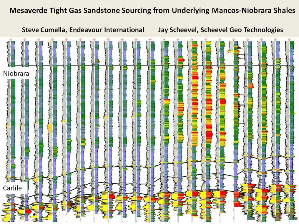
1 Mesaverde Tight Gas Sandstone Sourcing from Underlying Mancos-Niobrara Shales* Steve Cumella 1 and Jay Scheevel 2 Search and Discovery Article #10450 (2012)** Posted October 22, 2012 *Adapted from oral presentation given at AAPG Rocky Mountain Section Meeting, Grand Junction, Colorado, September 9-12, 2012 **AAPG 2012 Serial rights given by author. For all other rights contact author directly. 1 Endeavour International, Evergreen, Colorado (steve.cumella@endeavourcorp.com) 2 Scheevel Geo Technologies, grand Junction, Colorado (jay@scheevel.com) Abstract Recent drilling of Mancos-Niobrara shales in the Piceance Basin has identified a significant gas resource in the southern Piceance Basin, where numerous vertical and horizontal wells have encountered thick shale intervals with pervasive gas saturation that are locally highly pressured. Pressure data indicates Mancos-Niobrara pressure gradients near 1 psi/ft in some areas. Geological and geochemical data indicate that the Mancos-Niobrara has been a major source of gas for the overlying Mesaverde tight-gas accumulation. Vertical gas migration from thick, shaly Mancos-Niobrara to the Mesaverde may have occurred primarily along fault and fracture zones. The top of continuous gas saturation rises significantly adjacent to major structural features, such as the Rulison nose, the Crystal Creek anticline, and the Gibson Gulch graben. Mesaverde gas production is commonly enhanced in these areas. Very high capillary pressures are required to achieve the low water saturations that have been measured in Mesaverde sandstones that have microdarcy permeability. High capillary pressures could have been provided by vertical migration of highly pressured gas from the Mancos-Niobrara into the Mesaverde. Additionally, the highly pressured gas would have enhanced natural fracturing during migration and filling of the tight sandstone reservoirs, while significantly increasing reservoir permeability. References Cumella, S. P., and D.B. Ostby, 2003, Geology of the basin-centered gas accumulation, Piceance Basin, Colorado, in K.M. Peterson, T.M. Olson, and D.S. Anderson, (eds.), Piceance Basin Guidebook: RMAG, Denver, Colorado, p Cumella, S.P., and J. Scheevel, 2008, Stratigraphic and rock mechanics influence on Mesaverde gas distribution, Piceance Basin, Colorado, in S.P. Cumella, K.W. Shanley, and W.K. Camp, (eds.), Understanding, exploring, and developing tight gas sands: Hedberg Conference 2005, Vail, Colorado: AAPG Hedberg Series, no. 3, p Johnson, R.C., 1989, Geologic history and hydrocarbon potential of Late Cretaceous-Age, low permeability reservoirs, Piceance
2 Basin, western Colorado: U.S. Geological Survey Bulletin, 1787-E, 51 p. Ladd, J.H., 2001, An overview and development history of the Wattenberg field, in D.S. Anderson, J.W. Robinson, J.E. Estes-Jackson, and E.B. Coalson, (eds.), Gas in the Rockies: RMAG Special Publication, p Lillis, P.G., G.S. Ellis, M.P. Dempsey, S.P. Cumella, 2008, Origin of gas in Mamm Creek Field, Piceance Basin, Colorado: poster presentation, RMAG-COGA meeting, Denver, Colorado. Newsham, K.E., and J.A. Rushing, 2002, Laboratory and field observations of an apparent sub capillary-equilibrium water saturation distribution in a tight gas sand reservoir: 2002 Society of Petroleum Engineers Gas Technology Symposium, Calgary, Alberta, Canada, April 30-May 2, 2002, SPE Paper Passey, Q.R., K.M. Bohacs, W.L. Esch, R. Klimentidis, and S. Sinta, 2010, From oil- prone source rock to gas-producing reservoir geologic and petrophysical characterization of unconventional shale-gas reservoirs: SPE International Oil and Gas Conference and Exhibition in China, 8-10 June 2010, Beijing, China, SPE SPE Conference Proceedings, 29 p. doi: / MS. Yurewicz, D., 2005, Controls on gas and water distribution, Mesaverde basin center gas play, Piceance Basin, Colorado(abs.): AAPG Hedberg Conference, Understanding, Exploring, and Developing Tight Gas Sands, April 2005, Vail, Colorado.
3
4

5 Presenter s notes: The Piceance Basin is located in northwest Colorado. The outline of the basin is shown by the outcrop of the Mesaverde Group in green. The color-filled contours show the thickness of the continuously gas-saturated interval of the Williams Fork. The thickest gassaturated interval is located in the deepest part of the basin. The gas-saturated interval thins toward the basin margins. A thickness of about 1500 ft or more of gas-saturated interval is necessary for commercial Williams Fork production. The cross-section line for following cross sections is shown in red.

6 Presenter s notes: Seismic line across the southern part of the Piceance Basin. Inset map shows the location of the seismic line in blue.

7 Presenter s notes: Cross section showing the stratigraphy of the Mesaverde Group. The Iles Formation comprises the lower part of the Mesaverde. It contains three marine sandstone intervals, the Corcoran, Cozzette, and Rollins. The Williams Fork Formation extends from the top of the Rollins to the top of the Mesaverde. The lower part of the Williams Fork contains coals (shown in black), and is commonly referred to as the Cameo coal interval. Most of the sandstones in the Williams Fork are discontinuous fluvial sands. An exception is the middle and upper marine sandstones that are present in the southeast part of the Piceance Basin. Almost all production from the Piceance basin-centered gas accumulation is derived from the fluvial sandstones of the Williams Fork.
.")
8 Presenter s notes: This is the same cross section that was shown in the previous slide, but it is structurally datumed. The Williams Fork gassaturated interval extends from the top of the Rollins to the top of continuous gas saturation (shown in red). It is thickest in the deepest part of the basin, where thermal maturities are highest and the greatest amount of gas was generated.
9

10 Presenter s notes: Schematic cross section showing the Piceance basin-centered gas accumulation (BCGA) model. Gas-saturated sandstones are shown in red, water-saturated sandstones in blue. Coals in the lower Williams Fork, shown in black, are the main source of gas for the BCGA. Gas generation within a very low permeability setting resulted in overpressuring that caused a pervasive fracturing shown by small red arrows. In addition to the pervasive fracture system, vertical gas migration was aided by migration along major fault and fracture zones from the underlying thick marine shales of the Mancos-Niobrara interval.

11 Presenter s notes: In addition to providing a major source of gas, coals act as insulators to heat flow.
12
13

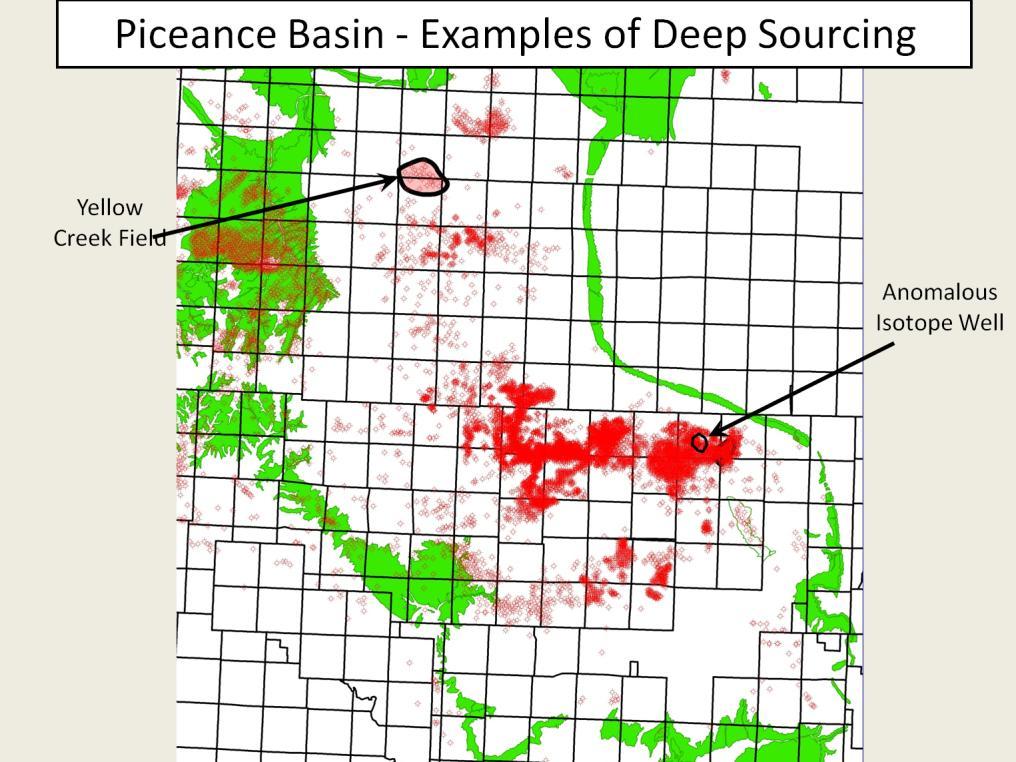
14 Presenter s notes: Yellow Creek Field is located on a plunging nose in the northern Piceance Basin. The thickness of the gas-saturated interval varies dramatically over relatively short distances. EURs are generally proportional to the thickness of the gas-saturated interval. In areas with thick intervals, EURS can be greater than 4 BCF; in area with thin intervals, EURs are about 0.5 BCF. Perhaps the best explanation for the dramatic variation in gas-saturated thickness is that most of the gas charge is a result of vertical migration along a major fault system that runs along the plunging nose. The primary gas source is the thick underlying Mancos-Niobrara marine-shale interval.

15 Presenter s notes: This cross section shows the dramatic variation in the thickness of the gas-saturated interval of the Williams Fork. The red arrows show the interpreted gas charge from underlying Mancos-Niobrara marine shales along a major fault system.

16 Presenter s notes: This cross section of numerous wells in Mamm Creek Field shows that, in contrast to the previous cross section across Yellow Creek Field, the gas-saturated interval is relatively constant. In Mamm Creek Field, abundant gas charge from the thick, thermally mature coals results in a relatively uniform gas-saturated interval.

17 Presenter s notes: Anomalous isotopic data from a well in Mamm Creek Field indicates a deep source for a well that has much heavier carbon isotopes, much higher methane content, and has an EUR that is three times better than the three other wells on the pad. All wells were drilled and completed in a similar manner at the same time and had a similar pay interval in terms of sand thickness.

18 Presenter s notes: Seismic data indicates that the well with the anomalous isotopic composition is located on a fault that might be a conduit for gas migration from the underlying Mancos-Niobrara interval. The interval for the horizon slice on the left is shown on the seismic section on the right.

19 Presenter s notes: The barrels of oil per MMCF changes dramatically across seismically defined fault zones in Mamm Creek Field.

20 Presenter s notes: Carbon isotopes in produced methane gas show significant changes across the same seismically defined fault zones shown in the previous map. The heavier isotopic values southwest of the fault zones indicate a more mature source.

21 Presenter s notes: This cross plot shows the data presented on the map in the previous slide. Two distinct populations of data are evident.

22 Presenter s notes: Geologic section to explain different gases produced from the Williams Fork in Mamm Creek Field. Thick, mature coals in the lower Williams Fork are an abundant source of gas that pervasively charges the Williams Fork throughout the field. This pervasive gas charge is indicated by the pink arrows. Additional gas charge is provided by vertical migration of Mancos-Niobrara gas along major fault zones (indicated by the red arrows). This gas is from an overmature source and has heavier carbon isotopes and higher methane content.

23 Presenter s notes: This cross plot of methane and ethane content from gas wells in Mamm Creek Field indicates a mixing line between Mancos wells that produce almost all methane and Williams Fork wells that produce much higher ethane. Some wells are completed in the Cozzette- Corcoran interval of the Iles Formation that immediately overlies the Mancos. These wells have compositions indicating a mix of Mancos and Mesaverde sources.

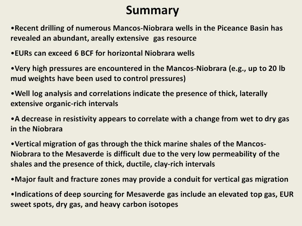
24 Presenter s notes: Numerous recent Mancos-Niobrara wells have demonstrated the presence of an abundant, laterally extensive gas resource.

25 Presenter s notes: Sonic logs and mudlogs from deep wells in the Uinta Basin indicate the presence of widespread organic-rich intervals. Organic-rich intervals have high gamma ray values, high mudlog gas and slow sonic velocities.

26 Presenter s notes: This map shows the location of the cross section in the following slide. Niobrara horizontal wells in Orchard Field have estimated EURs of 5-6 BCF.
, and color-filled delta-t is in track")
27 Presenter s notes: This cross section shows the stratigraphy of the Mancos-Niobrara interval in the southwestern Piceance Basin. Gamma ray is in track 1, resistivity and delta-t are cross-plotted in track 2 (red areas are intervals where resistivity is higher and sonic velocity is slower), and color-filled delta-t is in track 3. Organic-rich intervals tend to have high gamma-ray values, slow sonic velocities, and high resistivities.
. Niobrara resistivities are low in the shallow, relatively immature area on the left side of the map.")
28 Presenter s notes: Average Niobrara resistivities are shown by the color-filled contours (the legend for the resistivity values is shown in the lower left). Structure contours on top of the Rollins are shown in red (structure deepens to the northeast). Niobrara resistivities are low in the shallow, relatively immature area on the left side of the map. Resistivities increase with depth and increasing maturity toward the center of the map. There is an anomalous decrease in resistivity with even greater depth and higher maturity in the northeast part of the map. This anomalous resistivity reversal can be seen in the cross section in the following slide (cross section line shown in blue).

29 Presenter s notes: This cross section shows the change from low resistivity from the shallow area on the left to higher resistivities with depth. An anomalous decrease in resistivity occurs in the deepest, most mature wells on the left side of the cross section. The black arrow shows the interval targeted by many of the horizontal Niobrara wells. The interval on the well log in the following slide is shown by the red line on the second well from the right.

30 Presenter s notes: Log analysis by Chris Hansen of part of the Niobrara shown by the red line on the second well from the right in the previous slide.

31 Presenter s notes: A anomalous decrease in resistivity in the two deepest, most mature wells on the left side of the cross section is similar to the resistivity decrease shown on the Niobrara cross section in the southern Piceance.

32 Presenter s notes: Color-filled contours show maximum resistivities of the B bench of the Niobrara. The correlation of resistivity changes with fault trends indicates a possible structural control of resistivities. In general, resistivities increase with increasing thermal maturities. Indeed, resistivity mapping of the Niobrara has been a primary exploration tool for the Niobrara play in the DJ Basin. However, resistivities decrease in the most thermally mature area of Wattenberg. GORs increase with increasing thermal maturity, and the 20,000 GOR contour shown in red indicates the area with the highest thermal maturity.

33 Presenter s notes: The line for this cross section is shown in blue on the previous slide. The top of the Niobrara B Bench is shown by the MKR_3B on the cross section. The lower resistivities of the B Bench in the middle part of the cross section correspond to the low-resistivity area in the most thermally mature part of Wattenberg.

34 Presenter s notes: Passey (2010) noted that some shale-gas reservoirs at very high maturities can be significantly less than in the same formation at lower thermal maturities. However, the decrease in resistivity in the Niobrara maturity in the Piceance, Sand Wash, and DJ basins occurs approximately at the wet-gas-to-dry-gas transition (far below the Ro>>3 mentioned in the Passey paper). Passey (2010) suggests that a conductive precursor to graphite may be causing the reduction in resistivity.

35 Presenter s notes: A mechanism for removing water from organic-rich shales proposed by Newsham and Rushing (2002) may provide a possible explanation for the decrease in resistivity with increased maturation. They propose that the key element required to move water effectively is the process of vaporizing connate water into the gas phase. Laboratory data suggests that, at temperatures exceeding 280 o F to 300 o F, significant volumes of water vapor may be dissolved in the hydrocarbon gas. The water that is dissolved in the gas phase is very fresh, and as the fresh water dissolved in the hydrocarbon gas is expelled, the water remaining in the formation becomes increasingly saline. This increase in salinity would lower Rw, which would in turn lower formation resistivity.
36
Steve Cumella 1. Search and Discovery Article # (2009) Posted July 30, Abstract
 Posted July 30, Abstract") AV Geology of the Piceance Basin Mesaverde Gas Accumulation* Steve Cumella 1 Search and Discovery Article #110106 (2009) Posted July 30, 2009 *Adapted from oral presentation at AAPG Annual Convention,
AV Geology of the Piceance Basin Mesaverde Gas Accumulation* Steve Cumella 1 Search and Discovery Article #110106 (2009) Posted July 30, 2009 *Adapted from oral presentation at AAPG Annual Convention,
Demystifying Tight-gas Reservoirs using Multi-scale Seismic Data
 Demystifying Tight-gas Reservoirs using Multi-scale Seismic Data Overview Murray Roth* Transform Software and Services, Inc., Littleton, CO murray@transformsw.com Tom Davis Colorado School of Mines, Golden,
Sequence Stratigraphy of the Upper Cretaceous Niobrara Formation, A Bench, Wattenberg Field, Denver Julesburg Basin, Colorado*
 Sequence Stratigraphy of the Upper Cretaceous Niobrara Formation, A Bench, Wattenberg Field, Denver Julesburg Basin, Colorado* Lisa E. Remington LaChance 1 and Mark C. Robinson 1 Search and Discovery Article
RESERVOIR CATEGORIZATION OF TIGHT GAS SANDSTONES BY CORRELATING PETROPHYSICS WITH CORE-MEASURED CAPILLARY PRESSURE
 RESERVOIR CATEGORIZATION OF TIGHT GAS SANDSTONES BY CORRELATING PETROPHYSICS WITH CORE-MEASURED CAPILLARY PRESSURE Michael Holmes, Antony Holmes and Dominic Holmes, Digital Formation, Inc. Copyright 2004,
Mixed Reservoir Wetting in Unconventional Reservoirs and Interpretation of Porosity/Resistivity Cross Plots, Derived From Triple-combo Log Data
 Mixed Reservoir Wetting in Unconventional Reservoirs and Interpretation of Porosity/Resistivity Cross Plots, Derived From Triple-combo Log Data Michael Holmes DWLS November 14, 2017 Outline Introduction
2016 U.S. Geological Survey Assessment of Continuous Oil and Gas Resources in the Mancos Shale of the Piceance Basin
 2016 U.S. Geological Survey Assessment of Continuous Oil and Gas Resources in the Mancos Shale of the Piceance Basin U.S. Department of the Interior U.S. Geological Survey Uinta-Piceance Province Colorado
Basin and Petroleum System Modeling for Piceance Basin and Uncertainty Quan8fica8on
 Basin and Petroleum System Modeling for Piceance Basin and Uncertainty Quan8fica8on Yao Tong 1, Tapan Mukerji 1, Allegra Hosford Scheirer 1, Paul Weimer 2, Stephen Cumella 3, Kenneth Peters 4 1. Stanford
Search and Discovery Article #10532 (2013)** Posted October 21, Abstract
** Posted October 21, Abstract") Utilizing the Delta Log R Method for Determining Total Organic Carbon of the Niobrara Formation, B Bench, Denver-Julesburg Basin, Colorado and Wyoming* Madeline K. Beitz 1, Robert Cunningham 2, and Lisa
Utilizing the Delta Log R Method for Determining Total Organic Carbon of the Niobrara Formation, B Bench, Denver-Julesburg Basin, Colorado and Wyoming* Madeline K. Beitz 1, Robert Cunningham 2, and Lisa
Wattenberg Field Area, A Near Miss & Lessons Learned After 35 Years of Development History. Stephen A. Sonnenberg Robert J. Weimer
 Wattenberg Field Area, A Near Miss & Lessons Learned After 35 Years of Development History Stephen A. Sonnenberg Robert J. Weimer Front Wattenberg Field DJ Basin WYOMING Pay PIERRE SHALE Typical Depth
Overview of Selected Shale Plays in New Mexico*
 Overview of Selected Shale Plays in New Mexico* Ron Broadhead 1 Search and Discovery Article #10627 (2014)** Posted August 18, 2014 *Adapted from presentation at RMAG luncheon meeting, Denver, Colorado,
Atlantic Rim Coalbed Methane Play: The Newest SuccessfulCBM Play in the Rockies
 Atlantic Rim Coalbed Methane Play: The Newest SuccessfulCBM Play in the Rockies Robert A. Lamarre Lamarre Geological, Denver, Colorado Stephen K. Ruhl Anadarko Petroleum Corporation, The Woodlands, Texas
Enhanced Formation Evaluation of Shales Using NMR Secular Relaxation*
 Enhanced Formation Evaluation of Shales Using NMR Secular Relaxation* Hugh Daigle 1, Andrew Johnson 1, Jameson P. Gips 1, and Mukul Sharma 1 Search and Discovery Article #41411 (2014)** Posted August 11,
APPENDIX C GEOLOGICAL CHANCE OF SUCCESS RYDER SCOTT COMPANY PETROLEUM CONSULTANTS
 APPENDIX C GEOLOGICAL CHANCE OF SUCCESS Page 2 The Geological Chance of Success is intended to evaluate the probability that a functioning petroleum system is in place for each prospective reservoir. The
Recap and Integrated Rock Mechanics and Natural Fracture Study on the Bakken Formation, Williston Basin Abstract Figure 1:
 Recap and Integrated Rock Mechanics and Natural Fracture Study on the Bakken Formation, Williston Basin Cosima Theloy, Department of Geology & Geological Engineering Abstract The late Devonian to early
Bulletin of Earth Sciences of Thailand. Evaluation of the Petroleum Systems in the Lanta-Similan Area, Northern Pattani Basin, Gulf of Thailand
 Evaluation of the Petroleum Systems in the Lanta-Similan Area, Northern Pattani Basin, Gulf of Thailand Sirajum Munira Petroleum Geoscience Program, Department of Geology, Faculty of Science, Chulalongkorn
Trapping Mechanisms along North Similan and Lanta Trends, Pattani Basin, Gulf of Thailand
 Trapping Mechanisms along North Similan and Lanta Trends, Pattani Basin, Gulf of Thailand Piyaporn Aukkanit Petroleum Geoscience Program, Department of Geology, Faculty of Science, Chulalongkorn University,
Assessment of Shallow Biogenic Gas Resources In Montana
 Page No. 45-1 Assessment of Shallow Biogenic Gas Resources In Montana J.L. Ridgley *, T.C. Hester, S.M. Condon, T. Cook, L.O. Anna, P.G. Lillis, E.L. Rowan U.S. Geological Survey, Denver, CO 8225 ridgley@usgs.gov
Case Study of the Structural and Depositional-Evolution Interpretation from Seismic Data*
 Case Study of the Structural and Depositional-Evolution Interpretation from Seismic Data* Yun Ling 1, Xiangyu Guo 1, Jixiang Lin 1, and Desheng Sun 1 Search and Discovery Article #20143 (2012) Posted April
Envelope of Fracture Density
 Dragana Todorovic-Marinic* Veritas DGC Ltd., Calgary, Alberta, Canada dragant@veritasdgc.com Dave Gray, Ye Zheng Veritas DGC Ltd., Calgary, Alberta, Canada Glenn Larson and Jean Pelletier Devon Canada
Search and Discovery Article #20097 (2011) Posted January 31, 2011
 Posted January 31, 2011") Integrated Geological and Engineering Studies in Support of Producing Light Oil from a Frozen Reservoir: A Case Study from Umiat Oil Field, Northern Alaska* C. Hanks 1, J. Mongrain 2, A. Dandekar 2, P.
Integrated Geological and Engineering Studies in Support of Producing Light Oil from a Frozen Reservoir: A Case Study from Umiat Oil Field, Northern Alaska* C. Hanks 1, J. Mongrain 2, A. Dandekar 2, P.
The Niobrara Petroleum System, Rocky Mountain Region. Steve Sonnenberg & James Taylor Colorado School of Mines
 The Niobrara Petroleum System, Rocky Mountain Region Steve Sonnenberg & James Taylor Colorado School of Mines The Niobrara-Mancos Oil & Gas Play, Rocky Mountain Region Niobrara and Mancos Production, Rocky
An Analytic Approach to Sweetspot Mapping in the Eagle Ford Unconventional Play
 An Analytic Approach to Sweetspot Mapping in the Eagle Ford Unconventional Play Murray Roth*, Transform Software and Services, Denver, Colorado, Murray@transformsw.com Michael Roth, Transform Software
Geothermal Gradients and Geothermal Opportunities in the Piceance Basin, Colorado
 Geothermal Gradients and Geothermal Opportunities in the Piceance Basin, Colorado Paul Morgan, Colorado Geological Survey, 1313 Sherman Street, Room 715, Denver, CO 80203: morgan@mines.edu 1. Abstract
The Giant Continuous Oil Accumulation in the Bakken Petroleum System, Williston Basin
 The Giant Continuous Oil Accumulation in the Bakken Petroleum System, Williston Basin Stephen A. Sonnenberg Department of Geology and Geological Engineering Colorado School of Mines Williston Basin Conference
Thin Sweet Spots Identification in the Duvernay Formation of North Central Alberta*
 Thin Sweet Spots Identification in the Duvernay Formation of North Central Alberta* Ritesh K. Sharma 1 and Satinder Chopra 1 Search and Discovery Article #10902 (2017)** Posted January 16, 2017 *Adapted
Recap and Integrated Rock Mechanics and Natural Fracture Study in the Bakken Formation, Williston Basin
 Recap and Integrated Rock Mechanics and Natural Fracture Study in the Bakken Formation, Williston Basin EERC, 2011 Cosima Theloy PhD Candidate Department of Geology and Geological Engineering Colorado
Unconventional reservoir characterization using conventional tools
 Ritesh K. Sharma* and Satinder Chopra Arcis Seismic Solutions, TGS, Calgary, Canada Summary Shale resources characterization has gained attention in the last decade or so, after the Mississippian Barnett
Stephanie B. Gaswirth and Kristen R. Mara
 U.S. Geological Survey Assessment of Undiscovered Resources in the Bakken and Three Forks Formations, Williston Basin, North Dakota, Montana, and South Dakota, 2013 Stephanie B. Gaswirth and Kristen R.
OGIP Evaluation of Shale Gas and CBM with Basin Modeling and Gas Isotopes Interpretation*
 OGIP Evaluation of Shale Gas and CBM with Basin Modeling and Gas Isotopes Interpretation* Daniel Xia 1,2 and Yongchun Tang 1 Search and Discovery Article #40842 (2011) Posted November 30, 2011 *Adapted
Geologic influence on variations in oil and gas production from the Cardium Formation, Ferrier Oilfield, west-central Alberta, Canada
 Geologic influence on variations in oil and gas production from the Cardium Formation, Ferrier Oilfield, west-central Alberta, Canada Marco Venieri and Per Kent Pedersen Department of Geoscience, University
Assessing our untapped energy resources. Derek Reay Geological Survey of Northern Ireland
 Assessing our untapped energy resources Derek Reay Geological Survey of Northern Ireland Talk Outline Northern Ireland energy market Oil and Gas Exploration Description Exploration risks Application of
Petrophysical Charaterization of the Kwale Field Reservoir Sands (OML 60) from Wire-line Logs, Niger Delta, Nigeria. EKINE, A. S.
 from Wire-line Logs, Niger Delta, Nigeria. EKINE, A. S.") JASEM ISSN 1119-8362 All rights reserved Full-text Available Online at wwwbiolineorgbr/ja J Appl Sci Environ Manage December, 2009 Vol 13(4) 81-85 Petrophysical Charaterization of the Kwale Field Reservoir
JASEM ISSN 1119-8362 All rights reserved Full-text Available Online at wwwbiolineorgbr/ja J Appl Sci Environ Manage December, 2009 Vol 13(4) 81-85 Petrophysical Charaterization of the Kwale Field Reservoir
Petroleum Potential of the Application Area L12-4
 Petroleum Potential of the Application Area L12-4 The Application Area (L12-4) is underlain by the western Officer Basin, beneath the Gunbarrel Basin. The general basin architecture is outlined in Figure
Hydrocarbon Volumetric Analysis Using Seismic and Borehole Data over Umoru Field, Niger Delta-Nigeria
 International Journal of Geosciences, 2011, 2, 179-183 doi:10.4236/ijg.2011.22019 Published Online May 2011 (http://www.scirp.org/journal/ijg) Hydrocarbon Volumetric Analysis Using Seismic and Borehole
SAND DISTRIBUTION AND RESERVOIR CHARACTERISTICS NORTH JAMJUREE FIELD, PATTANI BASIN, GULF OF THAILAND
 SAND DISTRIBUTION AND RESERVOIR CHARACTERISTICS NORTH JAMJUREE FIELD, PATTANI BASIN, GULF OF THAILAND Benjawan KIinkaew Petroleum Geoscience Program, Department of Geology, Faculty of Science, Chulalongkorn
Calculating Total Organic Carbon (TOC) using the Passey Method
 using the Passey Method") Calculating Total Organic Carbon (TOC) using the Passey Method Chris Gent Overview 1. Passey method 2. Importance of TOC and maturity data. 3. Case Study: The Weald, UK. 1. The Passey Method A Practical
Calculating Total Organic Carbon (TOC) using the Passey Method Chris Gent Overview 1. Passey method 2. Importance of TOC and maturity data. 3. Case Study: The Weald, UK. 1. The Passey Method A Practical
Petroleum geology framework, West Coast offshore region
 Petroleum geology framework, West Coast offshore region James W. Haggart* Geological Survey of Canada, Vancouver, BC jhaggart@nrcan.gc.ca James R. Dietrich Geological Survey of Canada, Calgary, AB and
A Petrophysical Model to Quantify Pyrite Volumes and to Adjust Resistivity Response to Account for Pyrite Conductivity
 A Petrophysical Model to Quantify Pyrite Volumes and to Adjust Resistivity Response to Account for Pyrite Conductivity Presented at the 2013 AAPG ACE, Pittsburgh PA May 19-22 By Michael Holmes, Antony
Using Thermal Maturity to Identify the Most Productive Part of the Oil Window to Target in the Woodford Shale
 2 nd Annual Woodford Liquids-Rich January 28, 2015 Horizontal Targets Congress 2015 Using Thermal Maturity to Identify the Most Productive Part of the Oil Window to Target in the Woodford Shale Brian J.
Hydrocarbon Potential of the Marginal Fields in Niger Delta Oza Field, a case study*
 Hydrocarbon Potential of the Marginal Fields in Niger Delta Oza Field, a case study* J.N. Sahu 1, C.H.V. Satya Sai 1, V. Chintamani 1 and C. Vishnu Vardhan 1 Search and Discovery Article #20182 (2012)*
Debra K. Gomez 1 and David Brewster 2. Search and Discovery Article #10843 (2016)** Posted March 21, Abstract
** Posted March 21, Abstract") PS Petroleum Potential Onshore Southern Madagascar, Morandava Basin, Block 3114* Debra K. Gomez 1 and David Brewster 2 Search and Discovery Article #10843 (2016)** Posted March 21, 2016 *Adapted from poster
PS Petroleum Potential Onshore Southern Madagascar, Morandava Basin, Block 3114* Debra K. Gomez 1 and David Brewster 2 Search and Discovery Article #10843 (2016)** Posted March 21, 2016 *Adapted from poster
Verification of Archie Constants Using Special Core Analysis and Resistivity Porosity Cross Plot Using Picket Plot Method
 Int'l Journal of Computing, Communications & Instrumentation Engg. (IJCCIE) Vol. 4, Issue (207) ISSN 2349-469 EISSN 2349-477 Verification of Archie Constants Using Special Core Analysis and Resistivity
QUANTITATIVE ANALYSIS OF SEISMIC RESPONSE TO TOTAL-ORGANIC-CONTENT AND THERMAL MATURITY IN SHALE GAS PLAYS
 E: infoikonscience.com W: www.ikonscience.com QUANTITATIVE ANALYSIS OF SEISMIC RESPONSE TO TOTAL-ORGANIC-CONTENT AND THERMAL MATURITY IN SHALE GAS PLAYS Ebrahim Zadeh 12, Reza Rezaee 1, Michel Kemper 2
Osareni C. Ogiesoba 1. Search and Discovery Article #10601 (2014)** Posted May 31, 2014
** Posted May 31, 2014") Seismic Multiattribute Analysis for Shale Gas/Oil within the Austin Chalk and Eagle Ford Shale in a Submarine Volcanic Terrain, Maverick Basin, South Texas* Osareni C. Ogiesoba 1 Search and Discovery Article
Seismic Multiattribute Analysis for Shale Gas/Oil within the Austin Chalk and Eagle Ford Shale in a Submarine Volcanic Terrain, Maverick Basin, South Texas* Osareni C. Ogiesoba 1 Search and Discovery Article
Bulletin of Earth Sciences of Thailand
 Quantitative Seismic Geomorphology of Early Miocene to Pleistocene Fluvial System of Northern Songkhla Basin, Gulf of Thailand Oanh Thi Tran Petroleum Geoscience Program, Department of Geology, Faculty
B.C. s Offshore Oil and Gas: a Guide to the Geology and Resources.
 B.C. s Offshore Oil and Gas: a Guide to the Geology and Resources. Introduction Beneath the offshore regions of British Columbia are four moderately large, geologically young sedimentary basins (Figure
- logr separation method (the most widely used approach for estimating organic richness) - Clay Indicator-GR separation method
 - Clay Indicator-GR separation method") Total Organic Carbon estimates from wireline logs - Part #2 by Andrew Green A decisive factor for any producible shale resource system is the quantity of total organic carbon (TOC) present, as it provides
Total Organic Carbon estimates from wireline logs - Part #2 by Andrew Green A decisive factor for any producible shale resource system is the quantity of total organic carbon (TOC) present, as it provides
Hydrogen Index as a Maturity Proxy - Some Pitfalls and How to Overcome Them*
 Hydrogen Index as a Maturity Proxy - Some Pitfalls and How to Overcome Them* Mark H. Tobey 1 and Catherine E. Campbell 2 Search and Discovery Article #41964 (2016)** Posted December 12, 2016 *Adapted from
Conventional oil petroleum system of the Cenomanian - Turonian Blackstone Formation, Ferrier - Willesden Green - Gilby area, west-central Alberta
 Conventional oil petroleum system of the Cenomanian - Turonian Blackstone Formation, Ferrier - Willesden Green - Gilby area, west-central Alberta Kevin Greff, Department of Earth Sciences, Western University,
Characterization and 3D reservoir modelling of fluvial sandstones of the Williams Fork Formation, Rulison Field, Piceance Basin, Colorado, USA
 IOP PUBLISHING JOURNAL OF GEOPHYSICS AND ENGINEERING J. Geophys. Eng. 5 (2008) 158 172 doi:10.1088/1742-2132/5/2/003 Characterization and 3D reservoir modelling of fluvial sandstones of the Williams Fork
AAPG HEDBERG RESEARCH CONFERENCE
 AAPG HEDBERG RESEARCH CONFERENCE Reservoir Scale Deformation - Characterization and Prediction June 22-28, 1997, Bryce, Utah Stratigraphic Controls on Fracture Distribution in the Austin Chalk: An Example
Geology of the Louisiana Haynesville Shale Play
 Annual Institute on Mineral Law Volume 56 The 56th Annual Institute on Mineral Law Article 6 4-2-2009 Geology of the Louisiana Haynesville Shale Play Louis Gilbert Follow this and additional works at:
Migration Lag - What is it and how it affects Charge Risk and Fluid Properties*
 Migration Lag - What is it and how it affects Charge Risk and Fluid Properties* Zhiyong He 1 Search and Discovery Article #42014 (2017)** Posted February 20, 2017 *Adapted from oral presentation given
Geological Overview of the Niobrara Chalk Natural Gas Play
 Geological Overview of the Niobrara Chalk Natural Gas Play W. Lynn Watney Kansas Geological Survey KU Energy Research Center The University of Kansas Lawrence, KS Outline Geologic Setting Paleogeography
A 2-D Petroleum System Model for the Vallecitos Syncline, San Joaquin Basin, California *
 A 2-D Petroleum System Model for the Vallecitos Syncline, San Joaquin Basin, California * Meng He 1, Stephan Graham 1, J. Michael Moldowan 1, Kenneth E. Peters 1, Leslie B. Magoon 1, Carolyn Lampe 1, and
Sequence stratigraphy and coastal-plain channel architecture of the Cretaceous Blackhawk Formation, Wasatch Plateau, Utah
 Hiranya Sahoo Hiranya Sahoo is currently a Ph.D. candidate at the University of New Orleans. After receiving his M.S. degree in geology, he attended IIT, Bombay, receiving a Master in Technology degree
Structural Geology of the Mountains
 Structural Geology of the Mountains Clinton R. Tippett Shell Canada Limited, Calgary, Alberta clinton.tippett@shell.ca INTRODUCTION The Southern Rocky Mountains of Canada (Figure 1) are made up of several
Characteristics and accumulation mechanism of tight sandstone gas reservoirs in the Upper Paleozoic, northern Ordos Basin, China
 442 DOI 1.17/s12182-13-294-1 Characteristics and accumulation mechanism of tight sandstone gas reservoirs in the Upper Paleozoic, northern Ordos Basin, China Liu Guangdi 1 Shenghe 1, Sun Mingliang 1, Zhao
Characterizing Seal Bypass Systems at the Rock Springs Uplift, Southwest Wyoming, Using Seismic Attribute Analysis*
 Characterizing Seal Bypass Systems at the Rock Springs Uplift, Southwest Wyoming, Using Seismic Attribute Analysis* Yuri Ganshin 1 and Fred McLaughlin 1 Search and Discovery Article #80483 (2015)** Posted
Reservoir Engineering Aspects of Unconventional Reservoirs A Brief Introduction
 Reservoir Engineering Aspects of Unconventional Reservoirs A Brief Introduction Tom BLASINGAME Petroleum Engineering Texas A&M University College Station, TX 77843-3116 (USA) +1.979.255.8808 t-blasingame@tamu.edu
Search and Discovery Article #80542 (2016)** Posted August 8, 2016
** Posted August 8, 2016") Geomechanical Properties of the Upper Ordovician Macasty Shale and its Caprock, Anticosti Island: A Regional Evaluation for a Promising Tight Oil Play* Denis Lavoie 1 and Stephan Séjourné 2 Search and
Geomechanical Properties of the Upper Ordovician Macasty Shale and its Caprock, Anticosti Island: A Regional Evaluation for a Promising Tight Oil Play* Denis Lavoie 1 and Stephan Séjourné 2 Search and
Quantifying Bypassed Pay Through 4-D Post-Stack Inversion*
 Quantifying Bypassed Pay Through 4-D Post-Stack Inversion* Robert Woock 1, Sean Boerner 2 and James Gamble 1 Search and Discovery Article #40799 (2011) Posted August 12, 2011 *Adapted from oral presentation
SPE ATCE 2013 Special Session So We Frac'd the Well, Now What? Reservoir Engineering Aspects of Unconventional Reservoirs
 SPE ATCE 2013 Special Session So We Frac'd the Well, Now What? Reservoir Engineering Aspects of Unconventional Reservoirs Tom BLASINGAME Petroleum Engineering Texas A&M University College Station, TX 77843-3116
Shale Gas Potential in the Eastern Cordillera of Colombia*
 Shale Gas Potential in the Eastern Cordillera of Colombia* Mario Garcia-Gonzalez 1 Search and Discovery Article #10286 (2010) Posted December 17, 2010 *Adapted from oral presentation at AAPG International
PERMIAN BASIN RISING E&P ACTIVITY IN OFFSHORE TECHNOLOGY. Well completion advances What s new in expandable tubulars Deepwater risers go deeper
 JULY 2011 / DEFINING NG TECHNOLOGY OGY FOR EXPLORATION, DRILLING ING AND PRODUCTION ON / WorldOil.com RISING E&P ACTIVITY IN PERMIAN BASIN OFFSHORE TECHNOLOGY Seafloor seismic for congested fields Are
Key Elements of the Petroleum Systems of the Rockall and Slyne-Erris Basins
 Key Elements of the Petroleum Systems of the Rockall and Slyne-Erris Basins Bandon Corrib Dooish Atlantic Ireland Conference, Dublin, 1 st - 2 nd November 2016 Rockall and Slyne-Erris Basins Only 11 exploration
Outline 16: The Mesozoic World: Formation of Oil Deposits (with a side trip to the Devonian Marcellus Shale)
") Outline 16: The Mesozoic World: Formation of Oil Deposits (with a side trip to the Devonian Marcellus Shale) The first commercial oil well was drilled by Colonel Edwin Drake in Titusville, Pennsylvania,
Outline 16: The Mesozoic World: Formation of Oil Deposits (with a side trip to the Devonian Marcellus Shale) The first commercial oil well was drilled by Colonel Edwin Drake in Titusville, Pennsylvania,
Overview of Unconventional Energy Resources of Oklahoma
 Overview of Unconventional Energy Resources of Oklahoma By Brian J. Cardott (Oklahoma Geological Survey) Presented at OGS Conference on Unconventional Energy Resources in the Southern Midcontinent in Oklahoma
Devonian Petroleum Systems and Exploration Potential, Southern Alberta, Part 3 Core Conference
 Devonian Petroleum Systems and Exploration Potential, Southern Alberta, Part 3 Core Conference Andy Mort (1), Leonard Stevens (2), Richard Wierzbicki (2) Abstract Part 1: Devonian Petroleum Systems Dr.
Search and Discovery Article #10916 (2017)** Posted February 27, 2017
** Posted February 27, 2017") Unconventional Resource Play Potential of the Pennsylvanian Leo/Minnelusa Formations of the Powder River and Denver Basins: A Perspective via ntegrated Petroleum Systems Analysis* Michael Cheng 1, Tony
Unconventional Resource Play Potential of the Pennsylvanian Leo/Minnelusa Formations of the Powder River and Denver Basins: A Perspective via ntegrated Petroleum Systems Analysis* Michael Cheng 1, Tony
Seismic characterization of Montney shale formation using Passey s approach
 Seismic characterization of Montney shale formation using Passey s approach Ritesh Kumar Sharma*, Satinder Chopra and Amit Kumar Ray Arcis Seismic Solutions, Calgary Summary Seismic characterization of
MUHAMMAD S TAMANNAI, DOUGLAS WINSTONE, IAN DEIGHTON & PETER CONN, TGS Nopec Geological Products and Services, London, United Kingdom
 Geological and Geophysical Evaluation of Offshore Morondava Frontier Basin based on Satellite Gravity, Well and regional 2D Seismic Data Interpretation MUHAMMAD S TAMANNAI, DOUGLAS WINSTONE, IAN DEIGHTON
Maturity Modeling of Gomin and South Gomin fields Southern Pattani Basin, Gulf of Thailand
 Maturity Modeling of Gomin and South Gomin fields Southern Pattani Basin, Gulf of Thailand Patinya Jaithan Petroleum Geoscience Program, Department of Geology, Faculty of Science, Chulalongkorn University,
S. Mangal, G.L. Hansa, S. R. Savanur, P.H. Rao and S.P. Painuly Western Onshore Basin, ONGC, Baroda. INTRODUCTION
 5th Conference & Exposition on Petroleum Geophysics, Hyderabad-2004, India PP 782-787 Identification of Shallow Gas Prospects from DHI and Inversion Studies of 2D Seismic Data, Kosamba Oil field, South
Distribution of Overpressure and its Prediction in Saurashtra Dahanu Block, Western Offshore Basin, India*
 Distribution of Overpressure and its Prediction in Saurashtra Dahanu Block, Western Offshore Basin, India* Kanak R. Nambiar 1, B.K. Singh 2, R.N. Goswami 2, and K.R.K. Singh 2 Search and Discovery Article
Process, Zeit Bay Fields - Gulf of Suez, Egypt*
 PS Pressure Regime Evaluation, Role, and Contribution in Well Planning and Formation Evaluation Process, Zeit Bay Fields - Gulf of Suez, Egypt* Saber Moustafa Selim 1, Khaled Mohamed Abdallah 1, and Khalaf
EROMANGA BASIN SYMPOSIUM JOINTLY SPONSORED BY THE GEOLOGICAL SOCIETY OF AUSTRALIA AND THE PETROLEUM EXPLORATION SOCIETY OF AUSTRALIA (S.A.
 EROMANGA BASIN SYMPOSIUM JOINTLY SPONSORED BY THE GEOLOGICAL SOCIETY OF AUSTRALIA AND THE PETROLEUM EXPLORATION SOCIETY OF AUSTRALIA (S.A. BRANCHES) ABSTRACT VOLUME EDITED BY P.S. MOORE & T.J. MOUNT GEOLOGICAL
RPSEA Research Project Overview
 RPSEA Research Project Overview September 28, 2011 PTTC/DOE/RSPEA Gas Shales Workshop Charlotte Schroeder Secure Energy for America Secure Energy for America RPSEA A non profit corporation formed by a
Depositional History and Petroleum Potential of Ombilin Basin, West Sumatra - Indonesia, Based on Surface Geological Data*
 Depositional History and Petroleum Potential of Ombilin Basin, West Sumatra - Indonesia, Based on Surface Geological Data* Yahdi Zaim 1, Litto Habrianta 2, Chalid I. Abdullah 1, Aswan 1, Yan Rizal 1, Nurcahyo
Geological Classification of Seismic-Inversion Data in the Doba Basin of Chad*
 Geological Classification of Seismic-Inversion Data in the Doba Basin of Chad* Carl Reine 1, Chris Szelewski 2, and Chaminda Sandanayake 3 Search and Discovery Article #41899 (2016)** Posted September
EVALUATION OF KEY FACTORS AFFECTING SUCCESSFUL OIL PRODUCTION IN THE BAKKEN FORMATION, NORTH DAKOTA. Technology Status Assessment.
 EVALUATION OF KEY FACTORS AFFECTING SUCCESSFUL OIL PRODUCTION IN THE BAKKEN FORMATION, NORTH DAKOTA Technology Status Assessment Prepared by: James A. Sorensen Senior Research Manager Energy & Environmental
Unconventional Oil Plays Opportunity vs Risk
 Unconventional Oil Plays Opportunity vs Risk EnerCom s London Oil & Gas Conference 4 June 14, 2012 Sofitel London Danny D. Simmons 1000 BOPD - What a great well! 10,000 1,000 BOPD 100 10 12/2009 1/2010
Stratigraphy and Hydrocarbon Production from Pennsylvanian Age Granite Wash Reservoirs in the Western Anadarko Basin, Oklahoma and Texas
 Stratigraphy and Hydrocarbon Production from Pennsylvanian Age Granite Wash Reservoirs in the Western Anadarko Basin, Oklahoma and Texas John Mitchell, Managing Partner/Consulting Geologist Fall River
RWE Dea UK SNS Limited (50%, operator) Dana Petroleum (E&P) Limited (50%)
 Dana Petroleum (E&P) Limited (50%)") 1. Licence Information Licence Number P1726 Licence Round 25 th (2008) Licence Type Traditional Blocks 43/17a & 43/18a Licensees Work Programme RWE Dea UK SNS Limited (50%, operator) Dana Petroleum (E&P)
1. Licence Information Licence Number P1726 Licence Round 25 th (2008) Licence Type Traditional Blocks 43/17a & 43/18a Licensees Work Programme RWE Dea UK SNS Limited (50%, operator) Dana Petroleum (E&P)
Bulletin of Earth Sciences of Thailand. A study of Reservoir Connectivity in the Platong Field, Pattani Basin, Gulf of Thailand. Hathairat Roenthon
 A study of Reservoir Connectivity in the Platong Field, Pattani Basin, Gulf of Thailand Hathairat Roenthon Petroleum Geoscience Program, Department of Geology, Faculty of Science, Chulalongkorn University,
Figure 1 Extensional and Transform Fault Interaction, Influence on the Upper Cretaceous Hydrocarbon System, Equatorial Margin, West Africa.
 Figure 1 Extensional and Transform Fault Interaction, Influence on the Upper Cretaceous Hydrocarbon System, Equatorial Margin, West Africa. Presented to the 10th PESGB/HGS Conference on Africa E + P September
Licence P1368: Relinquishment Report (end of 2 nd term) Hurricane Exploration PLC
 Hurricane Exploration PLC") Licence P1368: Relinquishment Report (end of 2 nd term) Hurricane Exploration PLC March 2012 1. Header Licence Number: P1368 Licence Round: 23 rd Licence Type: Frontier Block Numbers: 202/4, 202/5, 204/30,
Licence P1368: Relinquishment Report (end of 2 nd term) Hurricane Exploration PLC March 2012 1. Header Licence Number: P1368 Licence Round: 23 rd Licence Type: Frontier Block Numbers: 202/4, 202/5, 204/30,
Abstract. 1. Introduction. Dan Kohlruss 1 and Kosta Stamatinos 2
 Preliminary Bulk Density Mapping of the Upper and Lower Bakken Member Shales of Southeastern Saskatchewan: A Potential Indicator for Oil Generation and Expulsion Dan Kohlruss 1 and Kosta Stamatinos 2 Kohlruss,
The Shale Spectrum: Interdisciplinary understanding across oil shale, oil-bearing shale and gas shale plays
 The Center for Oil Shale Technology & Research & The Colorado School of Mines 31sᵗOil Shale Symposium October 17-21, 2011 at the Cecil H. & Ida Green Center, Colorado School of Mines, Golden, Colorado
Bulletin of Earth Sciences of Thailand. Controls on Reservoir Geometry and Distribution, Tantawan Field, Gulf of Thailand.
 Controls on Reservoir Geometry and Distribution, Tantawan Field, Gulf of Thailand Atchara Praidee Petroleum Geoscience Program, Department of Geology, Faculty of Science, Chulalongkorn University, Bangkok
REGIONAL GEOLOGY IN KHMER BASIN
 CONTENTS 1-Khmere Basin 2-Regional Geology Khmer Basin 3-Regime Tectonic 4-Seismic Database -a/ Acquisition Data -b/ Prospect Angkor -C/ Cross Section Seismic 5-Play Type -a/ Play Schematic -b/ Structure
Delineating a sandstone reservoir at Pikes Peak, Saskatchewan using 3C seismic data and well logs
 Delineating a sandston reservoir at Pikes Peak Delineating a sandstone reservoir at Pikes Peak, Saskatchewan using 3C seismic data and well logs Natalia L. Soubotcheva and Robert R. Stewart ABSTRACT To
Relinquishment Report. Licence P2016 Block 205/4c
 Relinquishment Report Licence P2016 Block 205/4c September 2016 JX Nippon Exploration and Production (U.K.) Limited Idemitsu Petroleum UK Ltd. Table of Contents 1. Licence Information... 1 2. Licence Synopsis...
Origin and Evolution of Formation Waters in the West-Central Part of the Alberta Basin
 Page No. 004-1 Origin and Evolution of Formation Waters in the West-Central Part of the Alberta Basin Karsten Michael* University of Alberta, 1-26 ESB, Edmonton, AB T6G 2E3 karsten@ualberta.ca and Stefan
Core Technology for Evaluating the Bakken
 Core Technology for Evaluating the Bakken Fundamentals for Reservoir Quality Assessment and Completion Analysis John Kieschnick and Roberto Suarez-Rivera TerraTek 1 Topics Covered Core Technology Changes
MESOZOIC BASINS. North Carolina Geological Survey
 MESOZOIC BASINS North Carolina Geological Survey The 1823 organic act which created the North Carolina Geological Survey (NCGS) tasked us to examine, describe and map the geology, geologic hazards, and
Structural Deformation and Karst in the Devonian Waterways Formation: Examples from Outcrops along the Athabasca River*
 Structural Deformation and Karst in the Devonian Waterways Formation: Examples from Outcrops along the Athabasca River* Chris L. Schneider 1 and Matthias Grobe 2 Search and Discovery Article #51073 (2015)
For personal use only
 12 October 2012 Companies Announcement Office Australian Securities Exchange Limited 10th Floor, 20 Bond Street SYDNEY NSW 2000 ADVENT ENERGY LTD SHALE GAS DATA RELEASE MEC Resources Limited (ASX:MMR)
Evaluation of Neocomian Shale source rock In Komombo Basin, Upper Egypt
 Evaluation of Neocomian Shale source rock In Komombo Basin, Upper Egypt Abdelhady, A. 1, Darwish, M. 2, El Araby, A. 3 and Hassouba, A. 4 1 DEA Egypt, Cairo, Egypt 2 Geology Department, Faculty of Science,
Lower Skinner Valley Fill Sandstones: Attractive Exploration Targets on the Northeast Oklahoma Platform*
 Lower Skinner Valley Fill Sandstones: Attractive Exploration Targets on the Northeast Oklahoma Platform* By Jim Puckette 1 Search and Discovery Article #10050 (2003) *Adapted from presentation to Tulsa