P Forsmark site investigation. Collection of archive samples. Sara Nordén, Svensk Kärnbränslehantering AB. October 2007
|
|
|
- Victor Price
- 5 years ago
- Views:
Transcription
1 P Forsmark site investigation Collection of archive samples Sara Nordén, Svensk Kärnbränslehantering AB October 2007 Svensk Kärnbränslehantering AB Swedish Nuclear Fuel and Waste Management Co Box 5864 SE Stockholm Sweden Tel Fax
2 ISSN Tänd ett lager: SKB P P, R eller TR. Forsmark site investigation Collection of archive samples Sara Nordén, Svensk Kärnbränslehantering AB October 2007 Keywords: Peat, Lake sediment, Water moss, Aquatic biota, Fish, Bottom vegetation, Archive samples, AP PF This report concerns a study which was conducted for SKB. The conclusions Keywords: and viewpoints Kaka, presented Kakmonster, in the Mupparna, report are Kermit. those of the author and do not necessarily coincide with those of the client. This report concerns a study which was conducted for SKB. The conclusions and Data viewpoints in SKB s database presented can in the be changed report are for those different of the reasons. author(s) Minor and changes do not necessarily in SKB s database coincide will with not those necessarily of the client. result in a revised report. Data revisions may also be presented as supplements, available at A pdf version of this document can be downloaded from A pdf version of this document can be downloaded from
3 Abstract The site investigations at Forsmark were finished on June 30, The examination of the vast amount of acquired data will continue during some period to come, and questions or requests of complementing data may be asked by SKB s analysers as well as by authorities and other external examiners. It is essential that SKB is alerted to provide quick and relevant answers to such questions if and when they are asked. As a means to anticipate the work that may be necessary in order to address different types of questions within the discipline of ecosystems and to prepare answers to them, we have tried to foresee which archive samples that can be of use and then carried out a field sampling survey. In this report the collection of samples identified as important, but for different reasons previously not included in SKB archives, is described. It includes peat/sediment from a bog, lake sediments from three lakes, water moss from three locations in the area, and fish and bottom vegetation from the bay Asphällsfjärden. The report describes collection procedures, the character of the collected samples and data from the sampling. 3
4 Sammanfattning Platsundersökningarna i Forsmark avslutades den 30:e juni Granskningen av SKB:s arbete och de stora datamängder som insamlats kommer dock att pågå under en längre tid, och det är inte uteslutet att det kommer att ställas frågor eller att kompletterande data begärs av såväl SKB:s egen analyspersonal som av myndigheter och andra externa granskare. Det är väsentligt att SKB har hög beredskap för att snabbt ge relevanta svar på sådana frågor om och när de ställs. I syfte att förekomma och underlätta det arbete som kan bli nödvändigt för att förbereda svar på eventuella framtida frågor inom det ytekologiska ämnesområdet, har vi försökt förutse vilka arkivprover som kan vara av nytta för att smidigt kunna besvara framtida frågor och därefter genomfört en insamlingsinsats av dessa prover. I denna rapport beskrivs insamlingen av de prover som identifierats som viktiga men av olika anledningar tidigare inte inkluderats i SKB:s arkiv. Det gäller torv/sediment från en mosse, sjösediment från tre sjöar, bäckmossa från tre lokaler i området samt fisk och bottenvegetation från viken Asphällsfjärden. I rapporten beskrivs insamlingsteknik, de insamlade provens karaktär samt metadata från insamlingen. 4
5 Contents 1 Introduction 7 2 Objective and scope 9 3 Equipment Sediment and peat in wetland Sediment from lakes and marine environment Water moss from streams Aquatic biota from marine environment 12 4 Execution and results Sampling in wetland Sampling of lake sediment Collection of water moss from streams Sampling of marine biota Data and sample handling Nonconformities 19 References 21 Appendix 1 Samples from the wetland Rönningarna 23 Appendix 2 Samples from the lakes Bolundsfjärden, Eckarfjärden and Puttan 27 Appendix 3 Water moss samples from streams 37 5
6 1 Introduction This document reports the data gained by the activity Collection of archive samples, which is one of the activities performed within the site investigation at Forsmark. The work was carried out in accordance with activity plan AP PF In Table 1-1 controlling documents for performing this activity are listed. Activity plans are SKB s internal controlling documents. Original data from the reported activities are stored in the primary database Sicada. Data are traceable in Sicada by the Activity plan number (AP PF ). Only data in databases are accepted for further interpretation and modelling. The data presented in this report are regarded as copies of the original data. Data in the databases may be revised, if needed. Such revisions will not necessarily result in a revision of the P-report, although the normal procedure is that major revisions entail a revision of the P-report. Minor revisions are normally presented as supplements, available at Table 1 1. Controlling documents for performance of the activity. Activity plan Number Version Collection of archive samples AP PF
7 2 Objective and scope The site investigations at Forsmark were finished on June 30, 2007, but data analysis and modelling will continue during some period to come. It is possible, even probable, that different kinds of questions may be asked by SKB s analysers as well as by external examiners. It is important for SKB to be prepared to provide quick and relevant answers to such questions if and when they are brought up for discussion. As a means to anticipate the work that may be necessary in order to address different types of questions brought up for discussion within the discipline of ecosystems and to prepare answers to them, we have tried to foresee which archive samples that can be of use, and after that carried out a sampling survey in the field. In this report the collection of samples identified as important, but for different reasons previously not included in the SKB archives, is described together with the character of collected samples. The sampling was divided into four different parts: Sediment and peat in wetland. Sediment from lakes and marine environment. Moss from streams. Aquatic biota from marine environment. 9
, see Figure 3-")
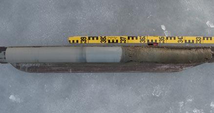
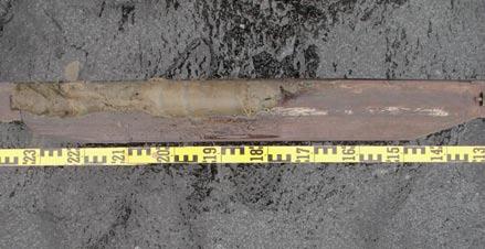
8 3 Equipment The equipments used when collecting all samples are described in the text below. 3.1 Sediment and peat in wetland The sampling of sediment and peat was conducted with a Russian peat corer (length 1 m and width 5 cm), see Figure Sediment from lakes and marine environment In order to obtain undisturbed samples of the whole sediment profile, two different samplers were used. The uppermost sediment was sampled using a freeze corer, see Figure 3-2, whereas the deeper samples were collected using a Russian peat corer described in the section above. The freeze corer consists of a thermos connected to a rather thin freeze wedge. The latter is made of stainless steel sheeting. It is filled with 95% ethanol. The thermos is made of stainless steel and double walled with insulation of polyurethane. Dry ice is filled in the thermos through a lid in the top onto which a gas-outlet is mounted. In an extension at the bottom of the thermos a trapdoor is assembled. This keeps the dry ice in the thermos until coring is initiated. The trapdoor is connected to the messenger-operated opening mechanism on the top of the thermos by a thin steel rod that runs inside the thermos. When the dry ice comes in contact with the alcohol an endothermic reaction occurs and the sediment freezes on the freeze wedge. The freezing process takes about minutes. Figure 3-1. Russian peat corer. 11

9 Figure 3-2. Freeze corer, before use (left), with sample (right). Two stabilizers with fins are used to make sure that the corer is not rotating when the bottom tip of the freeze wedge penetrates the sediment surface during descent. The equipment is designed for coring from ice. To melt loose the sample hot water is filled into the freeze wedge when the sampler has been pulled out of the water, see Figure 3-3. For more details about the freeze corer the reader is directed to /Renberg and Hansson in manus/. 3.3 Water moss from streams Water moss was hand sampled using plastic gloves. 3.4 Aquatic biota from marine environment For sampling of fish benthic multi-mesh gillnets of Nordic type were used. They are made of uncoloured nylon, and composed of 12 different mesh-sizes ranging between 5 55 mm. Each gillnet was 30 m long and 1.5 m wide, and each mesh panel was 2.5 m wide. The diameter of the thread varied between 0.10 mm for the 5 mm mesh to 0.23 for the 55 mm mesh. Sampling of submerged vegetation was performed using a rake. 12
 Poring hot water into the freezing wedge (left), 2) lifting out")
10 Figure 3-3. Detaching of the sediment sample. 1) Poring hot water into the freezing wedge (left), 2) lifting out the wedge (right). 13

11 4 Execution and results The sampling was performed by different staff and at different locations. The sampling and the result of the sampling are described in the following text. The sampling locations are shown on the maps presented in Figure 4-1 and Sampling in wetland The aim of the sampling was to obtain two additional parallel cores of the complete clay/gyttja/ peat succession from the wetland at Rönningarna. Previous investigations had indicated depths to till of approximately 3 m /Lokrantz and Hedenström 2006/. Glacial clay is overlain by a patchy sand cover which in turn is overlain by clayey gyttja, algae gyttja, reed peat and sphagnum peat. The sampling was performed by Joachim Albrecht from SGU and Annika Berntsson from University of Stockholm on March 28, The cores collected were shorter than expected and therefore a new sampling was performed on April 2. At that occasion somewhat longer cores were collected, although not as long as 3 m. Attempts were made at seven different locations in the wetland; however, none of them reached glacial clay due to refusal in the sand/gravel layer at approximately 2 m depth. The samples from both sampling occasions have been stored. Figure 4-1. Locations for sampling of water moss, sediment and peat, respectively. 15
, 5 to 10 cm reed peat, 30 to 40 cm gyttja (algal gyttja with Carex and Phragmites remains), 20 cm clayey gyttja and")
12 Figure 4-2. Locations for sampling of submerged vegetation and fish, in the sea bay Asphällsfjärden. The recovered stratigraphical succession includes (generalised, from top to bottom): more than 1.5 m poorly humified Sphagnum peat with increasing amount of reed (Phragmites), 5 to 10 cm reed peat, 30 to 40 cm gyttja (algal gyttja with Carex and Phragmites remains), 20 cm clayey gyttja and finally sand and gravel, which was not penetrated. The coring spots were marked with wooden poles and their locations estimated with a hand-held GPS receiver. The positions are shown on the map in Figure 4-1. Three of the parallel cores (PFM006026, PFM and PFM006029) have been stored cooled (c 5 C), while the last one (PFM006028) has been sliced into 2 cm thick samples which were freeze dried and thereafter stored dry and dark in small plastic jars. Some of the samples were weighed before and after the freeze drying in order to register the water content. Freeze drying took place at the University of Stockholm. The cool cores are stored in 1 m long plastic half-tubes and wrapped in plastic to prevent contamination. Photos of the sampled cores are presented in Appendix 1 together with other important information (stratigraphy, water content). 4.2 Sampling of lake sediment The sampling was performed by Mårten Strömgren and Fredrik Lindgren from University of Umeå between March 7 and 12, As described earlier two different sampling equipments were used for the uppermost and the deeper sediments, respectively. The collected samples were collected ensuring overlap. Sediment was collected from the lakes Bolundsfjärden, Eckarfjärden and Puttan, see Figure 4-1. Attempts to find collectable sediment was also performed in the lake Norra bassängen but without success. 16
13 The weather conditions were very harsh and therefore only two parallel samples could be collected from Puttan (two freeze sample cores and two Russian peat corer sequences). From Eckarfjärden three parallel cores were sampled whereas four freeze samples and three Russian peat corer samples were collected in Bolundsfjärden. At the sampling occasion in March no ice was present on the bay Asphällsfjärden and therefore no attempts were performed to sample sediment there. Earlier mapping of Quaternary deposits on the sea floor of the bay Asphällsfjärden /Ising 2005/ revealed few areas with soft sediment. No such area was found when sampling biological samples (see section 4.4). One of each parallel cores (PFM007371, PFM007372, PFM007377, PFM007380, PFM007387, PFM007390) has been sliced into 2 cm thick samples which were freeze dried and thereafter stored dry and dark in small plastic jars. The other samples collected with the freeze corer (PFM007373, PFM007375, PFM007379, PFM007381, PFM007382, PFM007386, PFM007388) are aimed to be stored frozen whereas the other Russian peat corer sequences (PFM007374, PFM007376, PFM007378, PFM007383, PFM007389, PFM007391) are aimed to be stored cooled (c 5 C). Some of the samples were weighted before and after the freeze drying in order to register the water content. Freeze drying took place at the University of Stockholm. The cool cores are stored on wooden deals in specially designed wooden boxes. The same kinds of boxes was also used for storage of the frozen sediment samples. Photos of the sampled cores are presented in Appendix 2 together with other important information (stratigraphy, water content, water depth). 4.3 Collection of water moss from streams The sampling of water moss (Fontinalis sp.) was performed by Sara Nordén, SKB, on May 21, The samples were collected at three different stream locations in the area, see Figure 4-1. The moss was sampled by hand using plastic gloves. At each location water moss from an area of approximately 5 m of the stream stretch was collected. Other species, as well as small stones and debris entangled in the moss, were removed and the moss was gently rinsed in the stream water. At one of the locations (South of Lake Stocksjön) the water level was very low and it was hard to rinse the moss. The water moss was put in a plastic bag and these were weighed on a balance with 0.2 g accuracy (see Table 4-1). The samples were thereafter stored in a freezer. Photographs from the sampling sites are presented in Appendix 3. Table 4-1. Weight of the sampled water moss. Idcode Sampling site Weight (g) PFM Gunnarsbo PFM South of Lake Stocksjön PFM Inlet to Lake Bolundsfjärden
14 4.4 Sampling of marine biota Sampling of marine biota was performed in the sea bay Asphällsfjärden between September 5 and 6, The sampling was performed by Sara Nordén, Niklas Heneryd and Björn Söderbäck at SKB. Bottom vegetation was sampled at three different locations, see map in Figure 4-2. At two of the locations Eurasian water milfoil (sw. Axslinga), Myriophyllum spicatum, was sampled and at the third location the species collected was Fennel Pondweed (sw. Borstnate), Potamogeton pectinatus. The samples were washed in the sea water and placed in plastic bags. They were later weighed and frozen. The weights of the samples are presented in Table 4-2. Four fishing nets were fastened to each other two and two so that two c 60 m long nets were gained. Each long net was placed in the bay Asphällsfjärden, see map in Figure 4-2, at the afternoon on September 5 and fetched the following morning. A list of all species caught can be seen in Table 4-3. A selection of the catch was weighed, put into plastic bags and then frozen. The table shows weight information for the archived specimens. The aim was to collect samples from the following functional groups; Zooplanktivorous fish (Z), Benthivorous fish (B) and Piscivorous fish (P). However, no piscivorous species were caught in the net fishing. Table 4-2. Bottom vegetation sampled in Asphällsfjärden on September 5, Idcode Species English name Species Latin name Species Swedish name Weight (g) PFM Eurasian water milfoil Potamogeton pectinatus Borstnate 170 PFM Fennel Pondweed Myriophyllum spicatum Axslinga 185 PFM Fennel Pondweed Myriophyllum spicatum Axslinga 200 Table 4-3. Fish species caught during the net fishing in the bay Asphällsfjärden during September 5 6, The fishes selected for freezing were weighed and their individual weights are given in gram. Species for which the weights are written on the same line have been placed together in one plastic bag. Idcode Species English namn Species Latin name Species Swedish name Weight (g) and functional group LFM Ide Leuciscus idus Id Perch Perca fluviatilis Abborre Roach Rutilus rutilus Mört Ruffe Gymnocephalus cernuus Gärs Bream Abramis brama Braxen Baltic herring Clupea harengus Strömming (Z) LFM Perch Perca fluviatilis Abborre (1) (B) Perch Perca fluviatilis Abborre (2) (B) Baltic herring Clupea harengus Strömming (Z) Roach Rutilus rutilus Mört Bream Abramis brama Braxen 121 (B) Bullhead Cottus sp. Simpa Ruffe Gymnocephalus cernuus Gärs (1) (B) Ruffe Gymnocephalus cernuus Gärs (2) (B) Bleak Alburnus alburnus Benlöja 18
 are stored at different locations in Oskarshamn.")
15 Figure 4-3. Fish caught during the net fishing in Asphällsfjärden. Above perch and below herring. 4.5 Data and sample handling Data for the collected archive samples have been stored in the database Sicada. Photos have been stored in the file archive of Sicada. The physical samples (sediment, plant material and fish) are stored at different locations in Oskarshamn. SKB has a special database, the Max database, where the location of all samples is registered. 4.6 Nonconformities At the sampling of peat and sediment from the bog Rönningarna the cores collected were shorter than expected and therefore a new sampling was performed. At that occasion somewhat longer cores were collected, although not 3 m as expected. Attempts were made at seven different locations in the wetland; however, none of them reached glacial clay due to refusal in the sand/gravel layer at approximately 2 m depth. No soft sediment which could be sampled by the equipment used was found in the lake Norra bassängen. Archive samples from this lake are therefore missing. At the sampling occasion in March 2007 no ice was present on the bay Asphällsfjärden, which prevented sampling. Therefore archive sediment samples from this bay are missing. According to the plan mussels should have been sampled in the bay Asphällsfjärden. During the sampling campaign in September 2007 attempts were performed with an Ekman grab sampler, but no mussels were found. Archive samples of marine mussels are therefore missing. No piscivorous fish species were caught in the net fishing in Asphällsfjärden so this kind of sample is also missing. 19
16 References Ising J, Forsmark site investigation. Mapping of Quaternary deposits on the bottoms of shallow bays outside Forsmark. SKB P Svensk Kärnbränslehantering AB. Lokrantz H, Hedenström A, Forsmark site investigation. Description, sampling and analyses if Quaternary deposits in connection with groundwater monitoring wells, pumping wells and BAT filter tips. SKB P Svensk Kärnbränslehantering AB. Renberg I, Hansson H. Department of Ecology and Environmental Science, Umeå University, Sweden. In manus. 21
17 Appendix 1 Samples from the wetland Rönningarna Table A1-1. Stratigraphy of the peat samples. The sample state at storage are given as C = cooled or FD = freeze-dried. Idcode From length To length Layer no Content State at storage Comments 23 PFM mossetorv C soil and vegetation PFM mossetorv C yellow-brownlow-humified Sphagnum peat, hiatus between 0.78 and 0.86 due to compactionduring coring PFM kärrtorv C yellow brown Phragmites peat PFM alggyttja C red brown algal gyttja, rich in coarse detritus PFM lergyttja-gyttjelera C greenish brown clayey gyttja with some detritus PFM lergyttja-gyttjelera C greenish grey clayey gyttja with sparse detritus PFM mossetorv C PFM mossetorv C dark brown Sphagnum peat PFM mossetorv C as above but darker PFM mossetorv C yellow brown low-humified Sphagnum peat, single herb roots, hiatus between 0.83 and 1.00 due to compaction during coring PFM mossetorv C yellow reddish brown low-humified Sphagnum peat, single Carex roots, Phragmites detritus, wet PFM kärrtorv C yellow brown Phragmites peat PFM alggyttja C red brown algal gyttja, rich in coarse detritus PFM gyttja C red brown gyttja with some detritus PFM lergyttja-gyttjelera C greenish grey clayey gyttja PFM mossetorv FD Soil and vegetation PFM mossetorv FD Dark brow Sphagnum peat PFM mossetorv FD Yellow brown low-humified Sphagnum peat, single herb roots, hiatus between 0.94 and 1.00 due to compaction during coring PFM mossetorv FD Yellow reddish brown low-humified Sphagnum peat, single Carex roots, wet PFM mossetorv FD Reddish brown low-humified Sphagnum peat, Carex roots, hiatus between 1.55 and 1.58
18 Idcode From length To length Layer no Content State at storage Comments 24 PFM kärrtorv FD Yellow brown Phragmites peat PFM alggyttja FD Red brown algae gyttja, rich in coarse detritus (Phragmites) PFM lergyttja-gyttjelera FD Greenish brown clayey gyttja with some detritus (Phragmites) PFM lergyttja-gyttjelera FD Greenish grey clayey gyttja with sparse detritus (Phragmites) PFM ishavs-/issjösediment FD Grey coarse sand PFM mossetorv C Soil and vegetation PFM mossetorv C Dark brown Sphagnum peat PFM mossetorv C Yellow brown low-humified Sphagnum peat, single herb roots, hiatus between 0.87 and 0.97 due to compaction during coring PFM mossetorv C Brown low-humified Sphagnum peat, single Phragmites roots and leaves PFM kärrtorv C Yellow brown Phragmites peat PFM alggyttja C Red brown algae gyttja, rich in coarse detritus (Phragmites) PFM lergyttja-gyttjelera C Greenish brown clayey gyttja with some detritus (Phragmites) PFM lergyttja-gyttjelera C Greenish grey clayey gyttja PFM ishavs-/issjösediment C Grey coarse sand
19 Table A2-2. Water content of peat samples. Idcode From length To length Water quotient (water loss per dry sample) Water content (water loss per wet sample) Comment 25 PFM From peat core PFM006028:1 PFM From peat core PFM006028:1 PFM From peat core PFM006028:1 PFM From peat core PFM006028:1 PFM From peat core PFM006028:1 PFM From peat core PFM006028:1 PFM From peat core PFM006028:1 PFM From peat core PFM006028:1 PFM From peat core PFM006028:1 PFM From peat core PFM006028:2 PFM From peat core PFM006028:2 PFM From peat core PFM006028:2 PFM From peat core PFM006028:2 PFM From peat core PFM006028:2 PFM From peat core PFM006028:2 PFM From peat core PFM006028:2 PFM From peat core PFM006028:2 PFM From peat core PFM006028:2 PFM From peat core PFM006028:3 PFM From peat core PFM006028:3


20 Figure A1-1. Part of the core from PFM Figure A1-2. Part of the core from PFM Figure A1-3. Part of the core from PFM
21 Appendix 2 Samples from the lakes Bolundsfjärden, Eckarfjärden and Puttan Table A2-1. Stratigraphy of the lake sediment samples. The sample state at storage are given as C = cooled, F = frozen or FD = freeze-dried. Lake Idcode From length To length Layer no Sampling equipment Content State at storage Comments 27 Eckarfjärden PFM water PFM Freeze corer gyttja FD Eckarfjärden PFM water PFM Russian peat corer gyttja FD PFM007372:1 PFM Russian peat corer gyttja FD PFM007372:3 PFM Russian peat corer sand/gravel FD PFM007372:2 PFM Russian peat corer gyttja FD PFM007372:3 PFM Russian peat corer sand/gravel FD PFM007372:3 PFM Russian peat corer clay FD Completely rigid to underlying till. Observe that the Russian peat corer has a 15 cm long tip. As a result c 15 cm of the clay have not been included in the sediment core. PFM007372:3 Eckarfjärden PFM water PFM Freeze corer gyttja F Eckarfjärden PFM water PFM Russian peat corer gyttja C PFM007374:1 PFM Russian peat corer gyttja C PFM007374:2 PFM Russian peat corer sand/gravel C PFM007374:2 PFM Russian peat corer clay C PFM007374:2 PFM Russian peat corer gyttja C PFM007374:3 PFM Russian peat corer sand/gravel C PFM007374:3 PFM Russian peat corer clay C Completely rigid to underlying till. Observe that the Russian peat corer has a 15 cm long tip. As a result c 15 cm of the clay have not been included in the sediment core. PFM007374:3
22 Lake Idcode From length To length Layer no Sampling equipment Content State at storage Comments 28 Eckarfjärden PFM water PFM Freeze corer gyttja F Eckarfjärden PFM water PFM Russian peat corer gyttja C PFM007376:1 PFM Russian peat corer gyttja C PFM007376:2 PFM Russian peat corer sand/gravel C PFM007376:2 PFM Russian peat corer clay C PFM007376:2 PFM Russian peat corer gyttja C PFM007376:3 PFM Russian peat corer sand/gravel C PFM007376:3 PFM Russian peat corer clay C Completely rigid to underlying till. Observe that the Russian peat corer has a 15 cm long tip. As a result c 15 cm of the clay have not been included in the sediment core. PFM007376:3 Bolundsfjärden PFM water PFM Freeze corer gyttja FD Bolundsfjärden PFM water PFM Russian peat corer gyttja C Bolundsfjärden PFM water PFM Freeze corer gyttja F Bolundsfjärden PFM water PFM Russian peat corer gyttja FD PFM Russian peat corer sand/gravel Completely rigid to underlying till. The 15 cm tip of the Russian peat corer also penetrated a shallow layer of sand/gravel. Nothing of that layer has been collected in the sediment core though. Bolundsfjärden PFM water PFM Freeze corer gyttja F Bolundsfjärden PFM water PFM Freeze corer gyttja F Bolundsfjärden PFM water PFM Russian peat corer gyttja C
23 Lake Idcode From length To length Layer no Sampling equipment Content State at storage Comments 29 Puttan PFM water PFM Freeze corer gyttja F Puttan PFM water PFM Russian peat corer gyttja FD PFM007387:1 PFM Russian peat corer gyttja FD Completely rigid to underlying till. The 15 cm tip of the Russian peat corer also penetrated a shallow layer of sand/gravel. Nothing of that layer has been collected in the sediment core though. PFM007387:2 Puttan PFM water PFM Freeze corer gyttja F Puttan PFM water PFM Russian peat corer gyttja C PFM007389:1 PFM Russian peat corer gyttja C Completely rigid to underlying till. The 15 cm tip of the Russian peat corer also penetrated a shallow layer of sand/gravel. Nothing of that layer has been collected in the sediment core though. PFM007389:2 Puttan PFM water PFM Freeze corer gyttja FD Puttan PFM water PFM Russian peat corer gyttja C PFM007391:1 PFM Russian peat corer gyttja C Completely rigid to underlying till. The 15 cm tip of the Russian peat corer also penetrated a shallow layer of sand/gravel. Nothing of that layer has been collected in the sediment core though. PFM007391:2
24 Table A2-2. Water content of lake sediment samples. Lake Idcode From length To length Water quotient (water loss per dry sample) Water content (water loss per wet sample) Comment Eckarfjärden PFM Eckarfjärden PFM Eckarfjärden PFM Eckarfjärden PFM From sediment core PFM007372:1 Eckarfjärden PFM From sediment core PFM007372:1 Eckarfjärden PFM From sediment core PFM007372:1 Eckarfjärden PFM From sediment core PFM007372:1 Eckarfjärden PFM From sediment core PFM007372:1 30 Eckarfjärden PFM From sediment core PFM007372:1 Eckarfjärden PFM From sediment core PFM007372:1 Eckarfjärden PFM From sediment core PFM007372:1 Eckarfjärden PFM From sediment core PFM007372:2 Eckarfjärden PFM From sediment core PFM007372:2 Eckarfjärden PFM From sediment core PFM007372:2 Eckarfjärden PFM From sediment core PFM007372:2 Eckarfjärden PFM From sediment core PFM007372:2 Eckarfjärden PFM From sediment core PFM007372:2 Eckarfjärden PFM From sediment core PFM007372:2 Eckarfjärden PFM From sediment core PFM007372:2 Eckarfjärden PFM From sediment core PFM007372:3 Eckarfjärden PFM From sediment core PFM007372:3
25 Lake Idcode From length To length Water quotient (water loss per dry sample) Water content (water loss per wet sample) Comment Eckarfjärden PFM From sediment core PFM007372:3 Eckarfjärden PFM From sediment core PFM007372:3 Eckarfjärden PFM From sediment core PFM007372:3 Eckarfjärden PFM From sediment core PFM007372:3 Bolundsfjärden PFM Bolundsfjärden PFM Bolundsfjärden PFM Bolundsfjärden PFM Bolundsfjärden PFM Bolundsfjärden PFM Bolundsfjärden PFM Bolundsfjärden PFM Bolundsfjärden PFM Bolundsfjärden PFM Bolundsfjärden PFM Bolundsfjärden PFM Bolundsfjärden PFM Bolundsfjärden PFM Bolundsfjärden PFM Puttan PFM From sediment core PFM007387:1 Puttan PFM From sediment core PFM007387:1 Puttan PFM From sediment core PFM007387:1 Puttan PFM From sediment core PFM007387:1 Puttan PFM From sediment core PFM007387:1
26 Lake Idcode From length To length Water quotient (water loss per dry sample) Water content (water loss per wet sample) Comment Puttan PFM From sediment core PFM007387:1 Puttan PFM From sediment core PFM007387:2 Puttan PFM From sediment core PFM007387:2 Puttan PFM From sediment core PFM007387:2 Puttan PFM From sediment core PFM007387:2 Puttan PFM From sediment core PFM007387:2 Puttan PFM From sediment core PFM007387:2 Puttan PFM From sediment core PFM007387:2 Puttan PFM From sediment core PFM007387:2 Puttan PFM Puttan PFM Puttan PFM Puttan PFM Puttan PFM Puttan PFM Puttan PFM


27 Photos of the lake sediment samples PFM (Eckarfjärden) PFM007372_1 (Eckarfjärden) PFM007372_2 (Eckarfjärden) PFM007372_3 (Eckarfjärden) PFM (Eckarfjärden) PFM007374_1 (Eckarfjärden) PFM007374_2 (Eckarfjärden) PFM007374_3 (Eckarfjärden) PFM (Eckarfjärden) PFM007376_1 (Eckarfjärden) 33


28 PFM007376_2 (Eckarfjärden) PFM007376_3 (Eckarfjärden) PFM (Bolundsfjärden) PFM (Bolundsfjärden) PFM (Bolundsfjärden) PFM (Bolundsfjärden) PFM (Bolundsfjärden) PFM (Bolundsfjärden) PFM (Bolundsfjärden) PFM (Puttan) 34


29 PFM007387_1 (Puttan) PFM007387_2 (Puttan) PFM (Puttan) PFM007389_1 (Puttan) PFM007389_2 (Puttan) PFM (Puttan) PFM007391_1 (Puttan) PFM007391_2 (Puttan) 35


30 Appendix 3 Water moss samples from streams Photos of the sampling sites. Figure A3-1. The water moss sampling site PFM (Gunnarsbo). Figure A3-2. The water moss sampling site PFM (South of Lake Stocksjön). 37

31 Figure A3-3. The water moss sampling site PFM (inlet to Lake Bolundsfjärden). 38
P Forsmark site investigation. Soil stratigraphy based on samples and protocols in the Forsmark area
 P-07-0 Forsmark site investigation Soil stratigraphy based on samples and protocols in the Forsmark area Joachim Albrecht, Sveriges Geologiska Undersökning January 007 Svensk Kärnbränslehantering AB Swedish
P Swedish National Seismic Network (SNSN) A short report on recorded earthquakes during the second quarter of the year 2007
 A short report on recorded earthquakes during the second quarter of the year 2007") P-07-163 Swedish National Seismic Network (SNSN) A short report on recorded earthquakes during the second quarter of the year 2007 Reynir Böðvarsson Uppsala University, Department of Earth Sciences July
P-07-163 Swedish National Seismic Network (SNSN) A short report on recorded earthquakes during the second quarter of the year 2007 Reynir Böðvarsson Uppsala University, Department of Earth Sciences July
P Oskarshamn site investigation. Boreholes KLX07A, KLX10, KLX05 and KLX12A
 P-07-63 Oskarshamn site investigation Boreholes KLX07A, KLX10, KLX05 and KLX12A Extensometer measurement of the coefficient of thermal expansion of rock Urban Åkesson SP, Technical Research Institute of
P Forsmark site investigation. Snow depth, ground frost and ice cover during the winter 2004/2005
 P-05-134 Forsmark site investigation Snow, ground frost and ice cover during the winter 2004/2005 Niklas Heneryd, Svensk Kärnbränslehantering AB June 2005 Svensk Kärnbränslehantering AB Swedish Nuclear
P Oskarshamn site investigation. Rock matrix permeability measurements on core samples from borehole KLX03
 P-07-204 Oskarshamn site investigation Rock matrix permeability measurements on core samples from borehole KLX03 Peter Vilks, Atomic Energy of Canada Ltd December 2007 Svensk Kärnbränslehantering AB Swedish
P Swedish National Seismic Network (SNSN) A short report on recorded earthquakes during the second quarter of the year 2011
 A short report on recorded earthquakes during the second quarter of the year 2011") P-11-35 Swedish National Seismic Network (SNSN) A short report on recorded earthquakes during the second quarter of the year 2011 Reynir Böðvarsson Uppsala University, Department of Earth Sciences July
P-11-35 Swedish National Seismic Network (SNSN) A short report on recorded earthquakes during the second quarter of the year 2011 Reynir Böðvarsson Uppsala University, Department of Earth Sciences July
P Forsmark site investigation. Ground penetrating radar and resistivity measurements for overburden investigations
 P-03-43 Forsmark site investigation Ground penetrating radar and resistivity measurements for overburden investigations Johan Nissen, Malå Geoscience AB April 2003 Svensk Kärnbränslehantering AB Swedish
P Swedish National Seismic Network (SNSN) A short report on recorded earthquakes during the third quarter of the year 2009
 A short report on recorded earthquakes during the third quarter of the year 2009") P-09-61 Swedish National Seismic Network (SNSN) A short report on recorded earthquakes during the third quarter of the year 2009 Reynir Böðvarsson Uppsala University, Department of Earth Sciences October
P-09-61 Swedish National Seismic Network (SNSN) A short report on recorded earthquakes during the third quarter of the year 2009 Reynir Böðvarsson Uppsala University, Department of Earth Sciences October
P Oskarshamn site investigation. Drillhole KSH01A. Extensometer measurement of the coefficient of thermal expansion of rock (SINTEF)
") P-05-59 Oskarshamn site investigation Drillhole KSH01A Extensometer measurement of the coefficient of thermal expansion of rock (SINTEF) Lisbeth Alnæs, SINTEF Civil and Environmental Engineering, Rock
P-05-59 Oskarshamn site investigation Drillhole KSH01A Extensometer measurement of the coefficient of thermal expansion of rock (SINTEF) Lisbeth Alnæs, SINTEF Civil and Environmental Engineering, Rock
P Swedish National Seismic Network (SNSN) A short report on recorded earthquakes during the third quarter of the year 2006
 A short report on recorded earthquakes during the third quarter of the year 2006") P-06-235 Swedish National Seismic Network (SNSN) A short report on recorded earthquakes during the third quarter of the year 2006 Reynir Böðvarsson Uppsala University, Department of Earth Sciences October
P-06-235 Swedish National Seismic Network (SNSN) A short report on recorded earthquakes during the third quarter of the year 2006 Reynir Böðvarsson Uppsala University, Department of Earth Sciences October
P Forsmark site investigation. Borehole: KFM01A Results of tilt testing. Panayiotis Chryssanthakis Norwegian Geotechnical Institute, Oslo
 P-03-108 Forsmark site investigation Borehole: KFM01A Results of tilt testing Panayiotis Chryssanthakis Norwegian Geotechnical Institute, Oslo June 2003 Svensk Kärnbränslehantering AB Swedish Nuclear Fuel
P Forsmark site investigation. Searching for evidence of late- or post-glacial faulting in the Forsmark region.
 P-03-76 Forsmark site investigation Searching for evidence of late- or post-glacial faulting in the Forsmark region Results from 2002 Robert Lagerbäck, Martin Sundh Geological Survey of Sweden (SGU) July
P Forsmark site investigation. Electric soundings supporting inversion of helicopterborne EM-data. Hans Thunehed, Timo Pitkänen GeoVista AB
 P-03-44 Forsmark site investigation Electric soundings supporting inversion of helicopterborne EM-data Hans Thunehed, Timo Pitkänen GeoVista AB January 2003 Svensk Kärnbränslehantering AB Swedish Nuclear
P Forsmark site investigation. Petrographic analysis of gravel and boulders in the Forsmark candidate area
 P-06-87 Forsmark site investigation Petrographic analysis of gravel and boulders in the Forsmark candidate area Torbjörn Bergman, Anna Hedenström Geological Survey of Sweden January 2006 Svensk Kärnbränslehantering
TR Technical Report. Buffer homogenisation, status report. Ann Dueck, Reza Goudarzi, Lennart Börgesson Clay Technology AB.
 Technical Report TR-12-2 Buffer homogenisation, status report Ann Dueck, Reza Goudarzi, Lennart Börgesson Clay Technology AB October 211 Svensk Kärnbränslehantering AB Swedish Nuclear Fuel and Waste Management
P Oskarshamn site investigation. Drill hole: KSH02. Extensometer measurement of the coefficient of thermal expansion of rock
 P-04-60 Oskarshamn site investigation Drill hole: KSH02 Extensometer measurement of the coefficient of thermal expansion of rock Urban Åkesson Swedish National Testing and Research Institute March 2004
P Oskarshamn site investigation. Borehole KLX04A Determination of P-wave velocity, transverse borehole core
 P-04-266 Oskarshamn site investigation Borehole KLX04A Determination of P-wave velocity, transverse borehole core Panayiotis Chryssanthakis, Lloyd Tunbridge Norwegian Geotechnical Institute October 2004
P Oskarshamn site investigation. Refraction seismic measurements in Laxemar spring Gustaf Lindqvist, MRM Konsult AB.
 P-06-49 Oskarshamn site investigation Refraction seismic measurements in Laxemar spring 2006 Gustaf Lindqvist, MRM Konsult AB June 2006 Svensk Kärnbränslehantering AB Swedish Nuclear Fuel and Waste Management
P Swedish National Seismic Network (SNSN) A short report on recorded earthquakes during the second quarter of the year 2003
 A short report on recorded earthquakes during the second quarter of the year 2003") P-03-79 Swedish National Seismic Network (SNSN) A short report on recorded earthquakes during the second quarter of the year 2003 Reynir Böðvarsson Uppsala University, Department of Earth Sciences August
P-03-79 Swedish National Seismic Network (SNSN) A short report on recorded earthquakes during the second quarter of the year 2003 Reynir Böðvarsson Uppsala University, Department of Earth Sciences August
P Oskarshamn site investigation. Borehole KLX12A. Determination of P-wave velocity, transverse borehole core
 P-06-70 Oskarshamn site investigation Borehole KLX12A Determination of P-wave velocity, transverse borehole core Panayiotis Chryssanthakis, Lloyd Tunbridge Norwegian Geotechnical Institute, Oslo October
P Oskarshamn site investigation. Modal analyses on rock mechanical specimens
 P-07-03 Oskarshamn site investigation Modal analyses on rock mechanical specimens Specimens from borehole KLX03, KLX04, KQ0064G, KQ0065G, KF0066A and KF0069A Thomas Janson, Björn Ljunggren Tyréns AB Torbjörn
P Swedish National Seismic Network (SNSN) A short report on recorded earthquakes during the first quarter of the year 2003
 A short report on recorded earthquakes during the first quarter of the year 2003") P-03-37 Swedish National Seismic Network (SNSN) A short report on recorded earthquakes during the first quarter of the year 2003 Reynir Böðvarsson Uppsala University, Department of Earth Sciences May 2003
P-03-37 Swedish National Seismic Network (SNSN) A short report on recorded earthquakes during the first quarter of the year 2003 Reynir Böðvarsson Uppsala University, Department of Earth Sciences May 2003
TR Technical Report. A coupled regolith-lake development model applied to the Forsmark site. Lars Brydsten, Mårten Strömgren Umeå University
 Technical Report TR-10-56 A coupled regolith-lake development model applied to the Forsmark site Lars Brydsten, Mårten Strömgren Umeå University November 2010 Svensk Kärnbränslehantering AB Swedish Nuclear
P Forsmark site investigation. Quantitative mapping of fracture minerals in Forsmark. Stefan Eklund, Karl-Johan Mattsson Geosigma AB
 P-08-47 Forsmark site investigation Quantitative mapping of fracture minerals in Forsmark Stefan Eklund, Karl-Johan Mattsson Geosigma AB December 2009 Svensk Kärnbränslehantering AB Swedish Nuclear Fuel
P Oskarshamn site investigation. Drill hole KAV01
 P-04-55 Oskarshamn site investigation Drill hole KAV01 Thermal properties: heat conductivity and heat capacity determined using the TPS method and Mineralogical composition by modal analysis Bijan Adl-Zarrabi
P Oskarshamn site investigation. Hydrochemical logging in KLX11A. Results from isotope determinations ( 3 H, δ 2 H and δ 18 O)
") P-07-37 Oskarshamn site investigation Hydrochemical logging in KLX11A Results from isotope determinations ( 3 H, δ 2 H and δ 18 O) Anna Lindquist, Geosigma AB February 2007 Svensk Kärnbränslehantering
P-07-37 Oskarshamn site investigation Hydrochemical logging in KLX11A Results from isotope determinations ( 3 H, δ 2 H and δ 18 O) Anna Lindquist, Geosigma AB February 2007 Svensk Kärnbränslehantering
P Forsmark site investigation. Data report from the laboratory investigations of the transport properties of the rock.
 P-06-186 Forsmark site investigation Data report from the laboratory investigations of the transport properties of the rock. Data delivery for data freeze Forsmark 2.2 Eva Gustavsson, Geosigma AB September
P Oskarshamn site investigation. Refraction seismic measurements in the water outside Simpevarp and Ävrö and on land on Ävrö
 P-04-201 Oskarshamn site investigation Refraction seismic measurements in the water outside Simpevarp and Ävrö and on land on Ävrö Gustaf Lindqvist, MRM Konsult AB April 2004 Svensk Kärnbränslehantering
Sediment Sampling Protocols
 Sediment Sampling Protocols February 2017 Sampler Training Workshop Thomas Seal, ES III Watershed Monitoring Section (WMS) Water Quality Assessment Program DEAR Tallahassee Sediment Sampling in Large and
Sediment Sampling Methods & Considerations. MSC-210 Marine Environmental Sampling & Analysis Lecture 7
 Sediment Sampling Methods & Considerations EQUIPMENT, DECONTAMINATION, PRESERVATION, STORAGE, & TRANSPORTATION MSC-210 Marine Environmental Sampling & Analysis Lecture 7 Purpose of Sediment Collection
Development of methodology for flow path analysis in the surface system Numerical modelling in MIKE SHE for Laxemar
 Report R-19-04 January 2019 Development of methodology for flow path analysis in the surface system Numerical modelling in MIKE SHE for Laxemar A report for the safety evaluation SE-SFL SVENSK KÄRNBRÄNSLEHANTERING
School of Chemistry Hazardous Waste Management Plan
 School of Chemistry Hazardous Waste Management Plan SOPs for the disposal of hazardous waste generated in the School of Chemistry Revision 2016.3.2 Page 1 Contents: Overview... Page 3 SOPs: Non-halogenated
7.1 PROTOCOL FOR SEDIMENT MONITORING FOR NUTRIENTS, METALS AND PHYSICAL CHARACTERISTICS
 7.1 PROTOCOL FOR SEDIMENT MONITORING FOR NUTRIENTS, METALS AND PHYSICAL CHARACTERISTICS Overview Sediments can be collected using either a grab or core sampler. Core samplers are tube-like devices that
P Oskarshamn site investigation. Hydrochemical logging in KLX09. Results from isotope determinations ( 3 H, δ 2 H and δ 18 O)
") P-06-311 Oskarshamn site investigation Hydrochemical logging in KLX09 Results from isotope determinations ( 3 H, δ 2 H and δ 18 O) Kersti Nilsson, Geosigma AB December 2006 Svensk Kärnbränslehantering
P-06-311 Oskarshamn site investigation Hydrochemical logging in KLX09 Results from isotope determinations ( 3 H, δ 2 H and δ 18 O) Kersti Nilsson, Geosigma AB December 2006 Svensk Kärnbränslehantering
Development and Testing of Bed Sediment Samplers Nazirah Apandi 1,a, Zulkiflee Ibrahim 1,b
 Development and Testing of Bed Sediment Samplers Nazirah Apandi 1,a, Zulkiflee Ibrahim 1,b 1 Faculty of Civil Engineering, Universiti Teknologi Malaysia, Malaysia a nazeera_jb@yahoo.com, b zulkfe@utm.my
Coring and sediment sampling
 Coring and sampling Principle: In order to ground-truth geophysical data, it is necessary to obtain a sample of the seabed. There are two main techniques available for sampling unconsolidated s : (1) seabed
Ms. A. Mormando's Class *
 8 th Grade Science Essential Standard: 8.E.1.1 Explain the structure of the hydrosphere including: Water distribution on Earth; Local river basin and water availability Stream - A stream is a body of water
P Results from Marine geological investigations outside Forsmark. Johan Nyberg, Anders Elhammer, Gustav Sohlenius Bernt Kjellin, Pär Nordgren
 P-11-39 Results from Marine geological investigations outside Forsmark Johan Nyberg, Anders Elhammer, Gustav Sohlenius Bernt Kjellin, Pär Nordgren Geological Survey of Sweden August 2011 Svensk Kärnbränslehantering
FINMARINET: Inventories and Planning for the Marine Natura 2000 Network in Finland. A.2 Geological inventories of the seafloor Final Report
 LIFE07 NAT/FIN/000151 FINMARINET: Inventories and Planning for the Marine Natura 2000 Network in Finland A.2 Geological inventories of the seafloor Final Report Geological Survey of Finland, GTK 1. Introduction
A pump freeze corer for recent sediments
 Notes 1317 Lmnol. Oceanogr., 38(6), 1993, 1317-1321 0 1993, by the American Society of Limnology and Oceanography, Inc. A pump freeze corer for recent sediments Abstract-A new freeze corer consists of
P Forsmark site investigation. Borehole KFM04A
 P-06-285 Forsmark site investigation Borehole KFM04A Thermal properties Anisotropic thermal conductivity and thermal diffusivity determined using the Hot Disk thermal constants analyser (the TPS technique)
Aquatic Plants of Eastman Pond, Eastman
 Aquatic Plants of Eastman Pond, Eastman State Contact: Amy P. Smagula Limnologist/Exotic Aquatic Plant Program Coordinator 603-271 271-22482248 or asmagula@des.state.nh.us Current status of exotic plant
P Forsmark site investigation
 P-3-14 Forsmark site investigation A ground geophysical survey prior to the siting of borehole KFM5A and KFM6A and control of the character of two SW-NE oriented lineaments Timo Pitkänen, Hans Thunehed,
Lower 8.3 Miles of the Lower Passaic River Operable Unit 2 Presentation to The Passaic River Community Advisory Group. September 14, 2017
 Lower 8.3 Miles of the Lower Passaic River Operable Unit 2 Presentation to The Passaic River Community Advisory Group September 14, 2017 Agenda Pre-Design Investigation (PDI) Status Geophysical, Bathymetric,
MCMURDO DRY VALLEYS ANTARCTICA
 POLAR WEEKEND MCMURDO DRY VALLEYS ANTARCTICA TOPIC: The McMurdo Dry Valleys, An Ecosystem of microbial life PROJECT PERSONNEL: Dr. Andrew G. Fountain, Geologist, Portland State University, Portland Oregon
P Oskarshamn site investigation. Petrographic analysis of gravel and boulders in till from the Laxemar area
 P-07-30 Oskarshamn site investigation Petrographic analysis of gravel and boulders in till from the Laxemar area Torbjörn Bergman, Gustav Sohlenius Geological Survey of Sweden March 2007 Svensk Kärnbränslehantering
HERZLIA MIDDLE SCHOOL
 NAME TEACHER S COMMENT TEACHER CLASS PARENT S COMMENT MARK PERCENTAGE PARENT SIGNATURE HERZLIA MIDDLE SCHOOL NATURAL SCIENCES GRADE 7 MID YEAR EXAMINATION 7 JUNE 2016 TIME: 90 Minutes MARKS: 145 1 Grade
The more common classification systems are enlisted below:
 A number of systems of classification have been evolved for categorizing various types of soil. Some of these have been developed specifically in connection with ascertaining the suitability of soil for
TR Technical Report. Input data report for the safety assessment SR-PSU. Svensk Kärnbränslehantering AB. December 2014
 Technical Report TR-14-12 Input data report for the safety assessment SR-PSU Svensk Kärnbränslehantering AB December 2014 Svensk Kärnbränslehantering AB Swedish Nuclear Fuel and Waste Management Co Box
Internet Interactive Rock Cycle
 Internet Interactive Rock Cycle Directions: Go to the website http://www.uky.edu/as/geology/howell/goodies/elearning/module05swf.swf and answer the questions below. Part I: Igneous Rocks (click on Igneous
Materials. Use materials meeting the following.
 208.01 Section 208. SOIL EROSION AND SEDIMENTATION CONTROL 208.01 Description. Install and maintain erosion and sedimentation controls to minimize soil erosion and to control sedimentation from affecting
Hydro One (Sept 2014) Hydro One (Sept 2014) Hydro One (Sept 2014)
 Hydro One (Sept 2014) Hydro One (Sept 2014)") TABLE 1 WELL CONSTRUCTION DETAILS MOE WWR No Well ID Location Installation Date Status Easting Coordinates Northing Source Elevation Screened Interval Screened Material Borehole Well Stick-up Ground Top
TABLE 1 WELL CONSTRUCTION DETAILS MOE WWR No Well ID Location Installation Date Status Easting Coordinates Northing Source Elevation Screened Interval Screened Material Borehole Well Stick-up Ground Top
UAS Student Residence
 General Notes, Abbreviations and Symbols C100 MATCH LINE - SEE SHEET L6 Existing Site Topographic Conditions C101 MATCH LINE - SEE SHEET L5 Existing Site Topographic Conditions C102 DEPTH(FT.) 5 FROZEN
GEOTECHNICAL REPORT. Matanuska-Susitna Borough. Parks Highway Connections Museum Drive. Matanuska-Susitna Borough, Alaska.
 Matanuska-Susitna Borough GEOTECHNICAL REPORT Parks Highway Connections Museum Drive Matanuska-Susitna Borough, Alaska March 2, 20 Prepared By: John Thornley, PE Geotechnical Engineer 333 Arctic Blvd.,
R Radio-nuclide particle transport, sedimentation and resuspension in the Forsmark and Laxemar coastal regions
 R-07-43 Radio-nuclide particle transport, sedimentation and resuspension in the Forsmark and Laxemar coastal regions Hanna Kling, Kristofer Döös Department of Meteorology, Stockholm University December
Site 3: Park Road, Katikati: field logs, stratigraphic description, and site description
 Appendix 4.2 Site 3: Park Road, Katikati: field logs, stratigraphic description, and site description Criteria suitability The third site selected was at Park Road Reserve, Katikati (Figure 1). This site
ESC102. Sedimentary Rocks. Our keys to the past. Monday, February 11, 13
 ESC102 Sedimentary Rocks Our keys to the past Sedimentary Rocks Sedimentary rocks are rocks that form through the accumulation of sediment and the process of lithification. Lithification occurs after deposition
APPENDIX C HYDROGEOLOGIC INVESTIGATION
 Figure B-5.7 Figure B-5.8 Preliminary Geotechnical and Environmental Report Appendix C Hydrogeologic Investigation APPENDIX C HYDROGEOLOGIC INVESTIGATION December 21, 2011 WESTSIDE SUBWAY EXTENSION PROJECT
Citizen Science Actions AIS Shoreline Survey Blocking Zebra Mussels Ice in, Ice off. Janet Andersen
 Citizen Science Actions AIS Shoreline Survey Blocking Zebra Mussels Ice in, Ice off Janet Andersen Shoreline search for new Aquatic Invasive Plants NYS DEC NYSFOLA Janet Andersen Shoreline Search Topics
P Oskarshamn site investigation. Borehole KLX16A. Uniaxial compression test of intact rock
 P-07-143 Oskarshamn site investigation Borehole KLX16A Uniaxial compression test of intact rock Lars Jacobsson SP Swedish National Testing and Research Institute June 2007 Svensk Kärnbränslehantering AB
P Oskarshamn site investigation. Sampling and analysis of precipitation at Simpevarp Ulf Ericsson, Alf Engdahl Medins Biologi AB
 P-06-324 Oskarshamn site investigation Sampling and analysis of precipitation at Simpevarp 2005 Ulf Ericsson, Alf Engdahl Medins Biologi AB December 2007 Svensk Kärnbränslehantering AB Swedish Nuclear
Environmental Science
 Environmental Science A Study of Interrelationships Cui Jiansheng Hebei University of Science and Technology CH06 Kinds of Ecosystems and Communities Chapter Objectives After reading this chapter, you
ADVENTURES IN WATER DEVELOPED BY LOUISVILLE WATER COMPANY
 ADVENTURES IN WATER DEVELOPED BY LOUISVILLE WATER COMPANY Tunneling for Water explains the science behind a first-of-its-kind project in the world! Louisville Water Company is the first water utility
5. Which surface soil type has the slowest permeability rate and is most likely to produce flooding? A) pebbles B) sand C) silt D) clay A) B) C) D)
 pebbles B) sand C) silt D) clay A) B) C) D)") 1. During a heavy rainstorm, soil samples A and B both became saturated with water. However, 10 minutes after the storm ended, the soils appeared as shown below. Which statement best explains the observed
1. During a heavy rainstorm, soil samples A and B both became saturated with water. However, 10 minutes after the storm ended, the soils appeared as shown below. Which statement best explains the observed
LEGEND BUSINESS ZONE NORTH OF AGRESEARCH BOREHOLE CPT SEISMIC CPT AUGER SCALE. Powells Road TEST PIT AGRESEARCH INNOVATION PARK. Hamilton Ring Road
 LEGEND ra R aku Ru BUSINESS ZONE NORTH OF Powells Road oad AGRESEARCH BOREHOLE CPT SEISMIC CPT AUGER SCALE 3 mm TEST PIT AS121 SCPT12 TP18 BH13 TP15 2 AS125 AS126 TP14 BH12 AGRESEARCH CPT13 TP17 INNOVATION
The role of macrophytes in Ladoga Lake ecosystems
 Russian State Hydrometeorological University Department of Applied Ecology The role of macrophytes in Ladoga Lake ecosystems Dr. Nadezhda Zuyeva Valaam 2010 One of the most important components of the
Landslides and Ground Water Permeability with Respect to the. Contact Point of Glacial Lake Vermont and the Champlain Sea
 Landslides and Ground Water Permeability with Respect to the Contact Point of Glacial Lake Vermont and the Champlain Sea Sediments at Town Line Brook, Winooski, VT Michala Peabody Lara Vowles Abstract:
Trace metal contamination of soils and sediments in the Port Kembla area, New South Wales, Australia
 University of Wollongong Thesis Collections University of Wollongong Thesis Collection University of Wollongong Year 2009 Trace metal contamination of soils and sediments in the Port Kembla area, New South
Sediment characteristics of Beaver Lake and implications for remediation; A Pilot Project.
 Sediment characteristics of Beaver Lake and implications for remediation; A Pilot Project. Delphine Faugeraux Leah Bendell A report to the Stanley Park Ecological Society. September 15 th 2011. Abstract
P Oskarshamn site investigation. Quantitative mapping of fracture minerals in Laxemar. Stefan Eklund, Karl-Johan Mattsson Geosigma AB
 P-08-38 Oskarshamn site investigation Quantitative mapping of fracture minerals in Laxemar Stefan Eklund, Karl-Johan Mattsson Geosigma AB January 2008 Svensk Kärnbränslehantering AB Swedish Nuclear Fuel
TR Technical Report. AFM study of montmorillonite
 Technical Report TR-1-27 AFM study of montmorillonite Torbjörn Pettersson, Esben Thormann, Per Claesson Department of Chemistry, Surface Chemistry Royal Institute of Technology February 21 Svensk Kärnbränslehantering
R Depth and stratigraphy of regolith at Forsmark. SR-PSU Biosphere. Gustav Sohlenius, Geological Survey of Sweden
 R-13-22 Depth and stratigraphy of regolith at Forsmark SR-PSU Biosphere Gustav Sohlenius, Geological Survey of Sweden Mårten Strömgren, Umeå University Fredrik Hartz, Hartz Technology AB December 2013
Aquatic Plants of Canaan Street Lake, Canaan
 Aquatic Plants of Canaan Street Lake, Canaan State Contact: Amy P. Smagula Limnologist/Exotic Aquatic Plant Program Coordinator 603-271-2248 or Amy.Smagula@des.nh.gov Current status of exotic plant infestations
Recommendations by Experts on the Required Parameters for Microplastics Monitoring in the Ocean As of 12 June 2018
 Recommendations by Experts on the Required Parameters for Microplastics Monitoring in the Ocean As of 12 June 2018 The following table shows recommendations on procedures for monitoring microplastics in
Ardaman & Associates, Inc. Geotechnical, Environmental and Materials Consultants
 SUBSURFACE SOIL EXPLORATION 42-INCH FORCE MAIN REPLACEMENT CHIQUITA BOULEVARD S AND SW 34 TH STREET CAPE CORAL, LEE COUNTY, FLORIDA Ardaman & Associates, Inc. Geotechnical, Environmental and Materials
Dry Muliwai Sample Location Map
 DMM2 DMM1 P:\AthruR\K838-Makua\GIS\Layouts\Dry Muliwai.mxd.mxd - 3/26/3 - JC DMM3 5 Dry Muliwai Sample Location Map Figure 2-4 P:\AthruR\K838-Makua\GIS\Layouts\orth Background Muliwai.mxd.mxd - 3/26/3
Background. 1 of 6 3/3/2011 4:16 PM
 1 of 6 3/3/2011 4:16 PM Modified with permission from Global Climates - Past, Present, and Future, S. Henderson, S. Holman, and L. Mortensen (Eds.). EPA Report No. EPA/600/R-93/126, U.S. Environmental
SOIL AND AGGREGATE FUNDAMENTALS STUDENT GUIDE AMRC April, 2006 AREA MANAGER ROADS CERTIFICATION PROGRAM FOR EDUCATIONAL PURPOSES ONLY
 AREA MANAGER ROADS CERTIFICATION PROGRAM AMRC 2011 SOIL AND AGGREGATE FUNDAMENTALS STUDENT GUIDE FOR EDUCATIONAL PURPOSES ONLY April, 2006 WPC #28013 07/09 2009 by British Columbia Institute of Technology
This document downloaded from vulcanhammer.net vulcanhammer.info Chet Aero Marine
 This document downloaded from vulcanhammer.net vulcanhammer.info Chet Aero Marine Don t forget to visit our companion site http://www.vulcanhammer.org Use subject to the terms and conditions of the respective
PRELIMINARY GEOTECHNICAL ENGINEERING REPORT. Proposed Re-Development 44 Old Worcester Road Charlton, Massachusetts. Prepared For:
 PRELIMINARY GEOTECHNICAL ENGINEERING REPORT Proposed Re-Development 44 Old Worcester Road Charlton, Massachusetts Prepared For: Meridian Associates, Inc. 500 Cummings Center, Suite 5950 Beverly, Massachusetts
Project: Vibration Damping
 Mekanik GK för I (FMEA10) 2018 Project: Vibration Damping Project team: Name: Personal id-number: Mekanik www.mek.lth.se. 1 Project: Vibration damping Project Specification 1. Introduction In this project
Surface Water Short Study Guide
 Name: Class: Date: Surface Water Short Study Guide Multiple Choice Identify the letter of the choice that best completes the statement or answers the question. 1. The three ways in which a stream carries
P Oskarshamn site investigation. Hydrochemical logging in KLX16A. Anna Lindquist, Geosigma AB. November 2007
 P-07-126 Oskarshamn site investigation Hydrochemical logging in KLX16A Anna Lindquist, Geosigma AB November 2007 Svensk Kärnbränslehantering AB Swedish Nuclear Fuel and Waste Management Co Box 250, SE-101
Weathering, Erosion and Deposition
 Weathering, Erosion and Deposition Shaping the Earth s Surface Weathering the process of breaking down rocks into smaller fragments Erosion the transport of rock fragments from one location to another
DELTA Test Report. DANAK TEST Reg. no Measurement of Sound Absorption Coefficient for Kvadrat Soft Cells Wall Panel Type Time
 We help ideas meet the real world DELTA Test Report DANAK TEST Reg. no. 100 Measurement of Sound Absorption Coefficient for Kvadrat Soft Cells Wall Panel Type Time Client: Kvadrat Soft Cells A/S Page 1
,Baynes Lake. TO...?&.?...A 2...KO.?'!!&... Sr. *logical Engineer
 > i evernment OF BRITISH COLUMBIA a TO...?&.?...A 2....KO.?'!!&... Sr. *logical Engineer... Grou,,water. Section Hydrology Division Wat.er... In~.~s.tiga.ti.On.s..Branck.... 5 u BJECT...C;.roun.dw.ater...Snve
The Use of Expanded Shale, Clay and Slate Lightweight Aggregates in Granular Geotechnical Fills
 Information Sheet 6660.0 January 2017 The Use of Expanded Shale, Clay and Slate Lightweight Aggregates in Granular Geotechnical Fills For over 50 years Rotary Kiln produced Expanded Shale, Clay & Slate
Changes to Land 5.7B. landforms: features on the surface of Earth such as mountains, hills, dunes, oceans and rivers
 All the landforms on Earth have changed over time and continue to change. Many of the changes were caused by wind, moving water, and moving ice. Mountains have grown and shrunk. Rivers have cut away land
EXTREMELY FAST IP USED TO DELINEATE BURIED LANDFILLS. Norman R. Carlson, Cris Mauldin Mayerle, and Kenneth L. Zonge
 EXTREMELY FAST IP USED TO DELINEATE BURIED LANDFILLS Norman R. Carlson, Cris Mauldin Mayerle, and Kenneth L. Zonge Zonge Engineering and Research Organization, Inc. 3322 East Fort Lowell Road Tucson, Arizona,
FORENSIC GEOLOGY A CIVIL ACTION
 NAME 89.215 - FORENSIC GEOLOGY A CIVIL ACTION I. Introduction In 1982 a lawsuit was filed on behalf of eight Woburn families by Jan Schlictmann. The suit alleged that serious health effects (childhood
Study of Scrubland Ecosystem
 Study of Scrubland Ecosystem INTRODUCTION In Hong Kong, scrubland is defined as land with fairly continuous cover of shrubs and bushes of 0.3 m to 2.9 m in height. Scrubland is a transitional stage between
Think about the landforms where you live. How do you think they have changed over time? How do you think they will change in the future?
 reflect All the landforms on Earth have changed over time and continue to change. Many of the changes were caused by wind, moving water, and moving ice. Mountains have grown and shrunk. Rivers have cut
Boreholes. Implementation. Boring. Boreholes may be excavated by one of these methods: 1. Auger Boring 2. Wash Boring 3.
 Implementation Boreholes 1. Auger Boring 2. Wash Boring 3. Rotary Drilling Boring Boreholes may be excavated by one of these methods: 4. Percussion Drilling The right choice of method depends on: Ground
Igneous Rocks. How Do Igneous Rocks Form? Liquid to Solid
 Igneous Rocks Answering the Big Question The activities in this lesson will help students answer the Big Question by modeling the result of different cooling rates of magma and lava and by learning how
FINAL STREAM. Prepared For: Discharge. Draft Stream. Level Hay Street, Subiaco WA Indiana Street. Golden, CO USA
 Draft Stream Discharge and Water Supply Estimates S F FINAL STREAM DISCHARGE AND WATER SUPPLYS ESTIMATES CITRONEN FJORD F DEVELOPMENT PROJECT Prepared For: Ironbark Zinc Limited Level 1 350 Hay Street,
Eelgrass biomass and production
 Eelgrass biomass and production Objectives To introduce methods for assessing basic parameters fundamental to many seagrass studies such as shoot size and stand structure expressed as biomass and shoot
Soil Sample Preparation Protocol (Modified from Faegri and Iversen 1 ; Moore and Webb 2 protocols)
") Soil Sample Preparation Protocol (Modified from Faegri and Iversen 1 ; Moore and Webb 2 protocols) Materials Sediment samples Volumetric sampler Metal spatula Permanent marker 15 ml Conical centrifuge
Soil Sample Preparation Protocol (Modified from Faegri and Iversen 1 ; Moore and Webb 2 protocols) Materials Sediment samples Volumetric sampler Metal spatula Permanent marker 15 ml Conical centrifuge
WM2014 Conference, March 2 6, 2014, Phoenix, Arizona, USA
 Experimental Comparison between High Purity Germanium and Scintillator Detectors for Determining Burnup, Cooling Time and Decay Heat of Used Nuclear Fuel - 14488 Peter Jansson *, Sophie Grape *, Stephen
Appendix E. Phase 2A Geotechnical Data
 Appendix E Phase 2A Geotechnical Data Appendix E1 Geotechnical Testing of Sediment ApPENDIX El. GEOTECHNICAL TESTING OF SEDIMENT (Modified from Exponent, 20Q1c) E.I Introduction This appendix presents
EARTH S CHANGING SURFACE
 EARTH S CHANGING SURFACE Weathering Together, weathering and erosion work continuously to wear down the material on Earth s surface. weathering process that breaks down rock and other substances of Earth