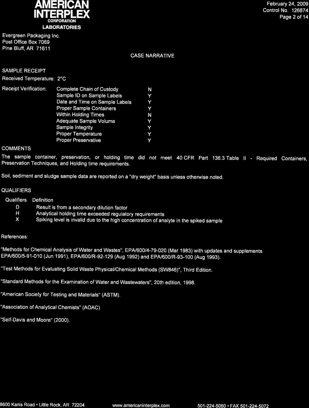
Evergreen Packaging, Inc. Waste Management Plan
|
|
|
- Penelope Laurel Barton
- 5 years ago
- Views:
Transcription

1 Evergreen Packaging, Inc. Waste Management Plan June 29, 2012
2 Waste Management Plan Prepared for: Evergreen Packaging, Inc. Pine Bluff Mill 5201 Fairfield Road Pine Bluff, AR Prepared by: GBM c & Associates 219 Brown Lane Bryant, AR June 29, 2012
3 CONTENTS 1.0 INTRODUCTION WASTE GENERATING PROCESS AND ANNUAL PRODUCTION WASTE STORAGE PRACTICES WASTE TRANSPORTATION AND APPLICATION METHODS SLUDGE CHARACTERISTICS LOCATION MAPS SITE MANAGEMENT PLAN Waste Application Rate Calculations Soil Analysis Application Area Map Information FIGURES Figure 1. Schematic diagram of wastewater treatment Figure 2. Topographic View of Evergreen Facility Figure 3. Aerial View of Evergreen facility Figure 4. Six application fields (Fields A-F) utilized by Evergreen Figure 5. Flood Insurance Map TABLES Table 1. Sludge storage practices and location Table 2. Sludge Waste Analytical Data Average concentration values of Evergreen s sludge sources from 2008 to Table 3. Sludge Analysis - Total plant available nitrogen (PAN), dry basis Table 4. Calculated sludge application rates Table 5. Total acres required per sludge product Table 6. Average soil characteristics for fields A, D, and E June 29, 2012 i
4 APPENDICES Appendix A Arkansas Permit No WR-4 Appendix B Land Application Soil Information Appendix C Soil and Waste Analysis Summary ( ) Appendix D Historical Analytical Data ( ) June 29, 2012 ii
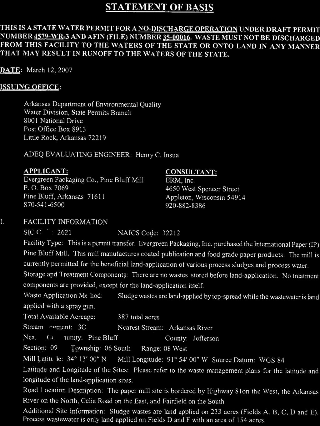
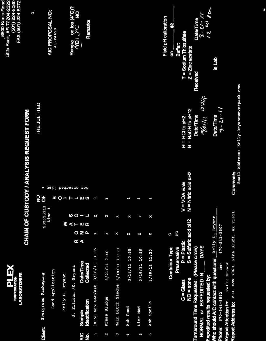
5 1.0 INTRODUCTION Evergreen Packaging, Inc (Evergreen) in Pine Bluff, Arkansas, manufactures coated publication and food grade paper products and is currently permitted (State Permit No WR-4) to operate and maintain a waste disposal system for the land application of sludge wastes and process water. A copy of this permit is located in Appendix A. The sludge waste land applied include; Ash Pond Solids, Lime Mud Solids, Main Ditch Sludge, Aeration Basin Spoils, Green Liquor Dreg/Ash (50:50 mixture), and Brownstock Pulping Knots. Other sludge sources are generated by the Evergreen manufacturing process and may include unclaimed raw materials, byproducts, and waste material typically associated with the production of paper. Figure 1 shows a schematic diagram of the wastewater treatment. The sludge management plan (Plan) covers the land application of the sludge waste, manufacturing byproducts. The Plan also documents the characteristics of the applied sludge, soil characteristics of the land application sites, and methods utilized in the application process. Evergreen s waste disposal system is operated and maintained in accordance with this Plan. June 29,
6 Figure 1. Schematic diagram of wastewater treatment. June 29,
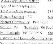
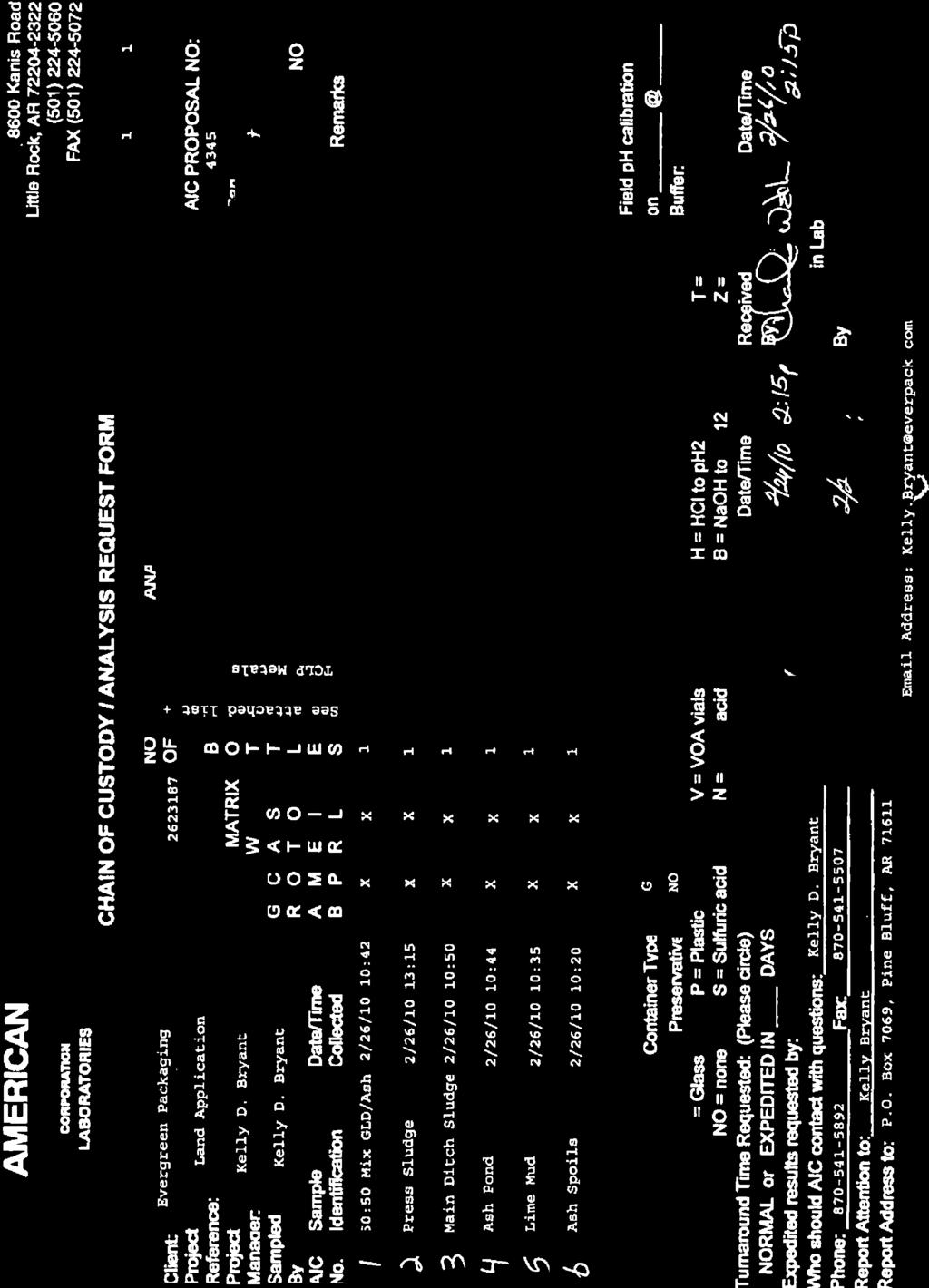
7 2.0 WASTE GENERATING PROCESS AND ANNUAL PRODUCTION Sludge from the facility is generated from two sources: 1) the wastewater treatment system, and 2) the manufacturing process. The sludges generated from the wastewater treatment system are solids dredged from the ASB and the Main Ditch. Other sludge sources may include unclaimed raw materials, byproducts, and waste material. Annual sludge production quantities are recorded by Evergreen on monthly summary land application spreadsheets. Since 2008, Evergreen has averaged approximately 91,260 cubic yards/year land applied. Sources applied since 2008 have included a mixture of Green Liquor Dreg (GLD) and Ash, ASB Spoils, Ash Pond, and Lime Mud. Recent sludge application volumes are as follows: 2008: 91,660 cubic yards with an average consistency of 30% solids, was land applied. 2009: 99,016 cubic yards with an average consistency of 32% solids, was land applied. 2010: 83,100 cubic yards with an average consistency of 55% solids, was land applied. Evergreen s permit was modified in August 2006 to include process wastewater; however, process wastewater has not been land applied since its permit date. The permit renewal in removed the inclusion of process wastewater land application. 3.0 WASTE STORAGE PRACTICES Table 1 below explains the storage practices and locations of sludge waste generated at the Evergreen facility. June 29,
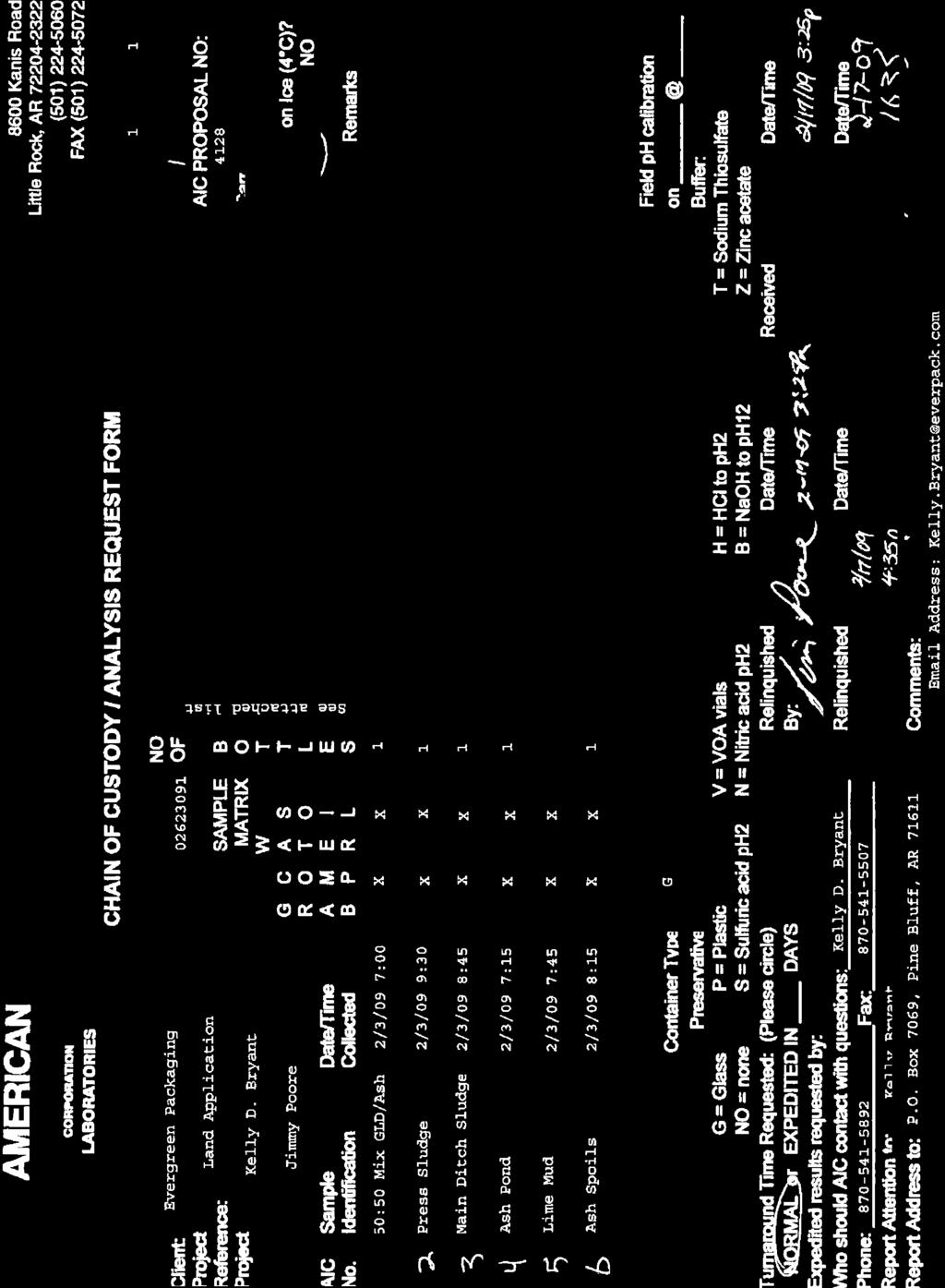
8 Table 1. Sludge storage practices and location. Ash Source Lime Mud Main Ditch ASB Spoils Green Liquor Dreg (GLD) Knots Storage Practice and Location Typically stored in one of 2 concrete lined ponds located west of the Main Ditch (Ash Ponds). Excess water decanted and returned to Main Ditch. Typically stored in one of 2 concrete lined ponds located west of the Main Ditch (Ash Ponds). Excess water decanted and returned to Main Ditch. Stockpiled along both sides of the Main Ditch. Stockpiled within Mill Facility. Typically stored on either a concrete pad surrounding the lined ponds or in a section of the ponds. Stored on the solid waste fuel pad. 4.0 WASTE TRANSPORTATION AND APPLICATION METHODS Evergreen is permitted to land apply sludge to six areas surrounding the facility. Figures 2 through 4 provide topographic and aerial views of the Evergreen facility location and show the locations of the six application fields (Fields A-F). An independent farmer under Evergreen s guidance farms the land application areas. The individual sludge sources are not combined prior to land application. The sludges are loaded in a dump truck or spreader equipment at their respective storage locations and moved directly to the land application areas. During transfer, none of the sludge is carried over public roads or on property that does not belong to Evergreen. Spreading equipment at the application areas distributes the sludge as evenly as possible. As stated in Section 2.0, each sludge source has a relatively high percent solid, minimizing runoff potential. However, runoff from the application of sludge is contained through the use of berms constructed during the application process. Berms are constructed so that runoff is not allowed to leave the application area. Each field is isolated by the installation of a perimeter berm. A minimum fifty-foot buffer zone is maintained between land application areas and land not owned by Evergreen. A one hundred-foot buffer is maintained between application areas and any creek or ponding water. Sludge is not applied during periods of standing water or during a time when rainfall is occurring or expected. After the sludge and soil has dried, the land is disked to mix the sludge and soil. June 29,

9 Figure 2. Topographic View of Evergreen Facility. June 29,

10 Figure 3. Aerial View of Evergreen facility. June 29,
")
11 Figure 4. Six application fields (Fields A-F) utilized by Evergreen. June 29,
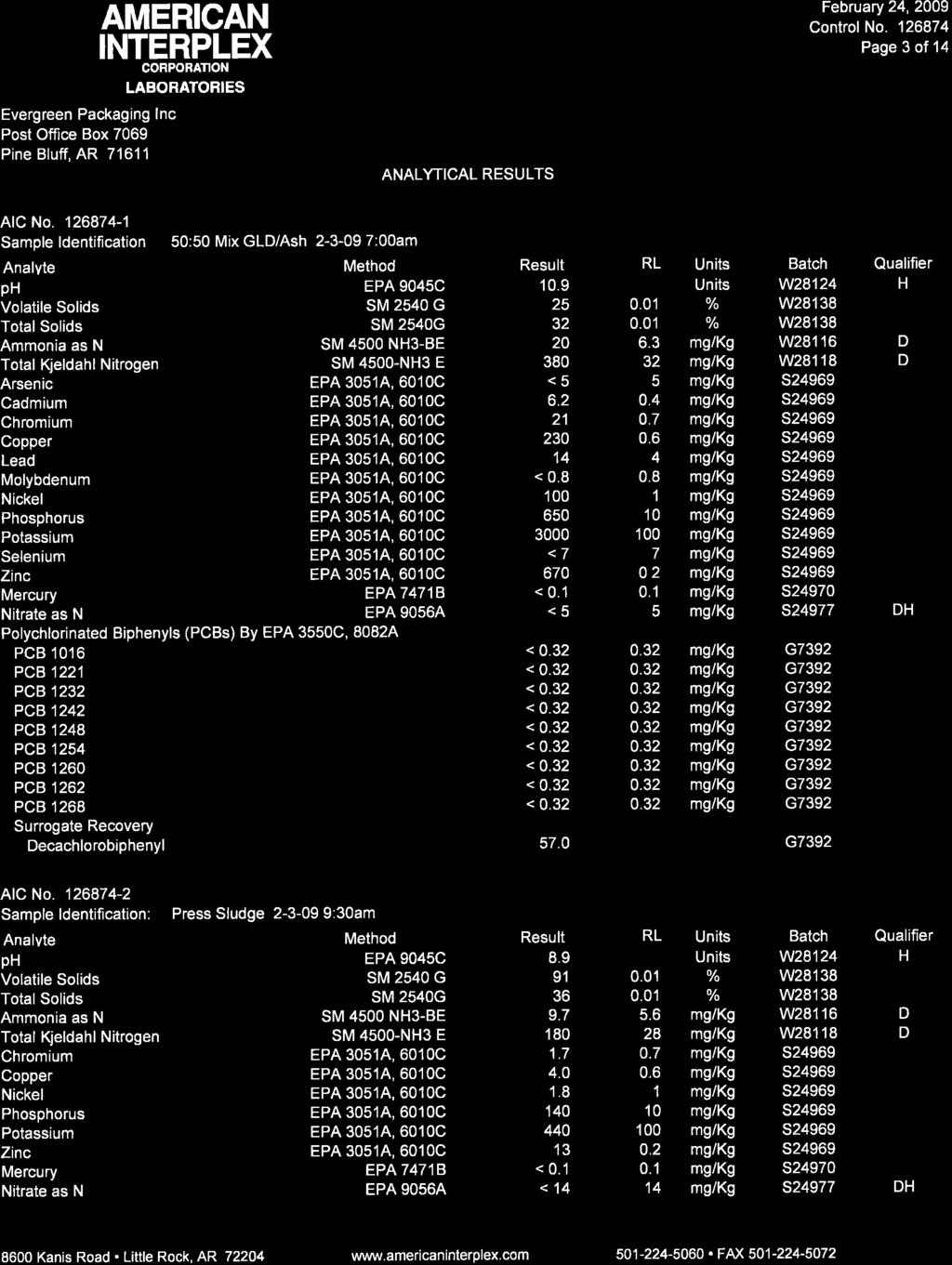
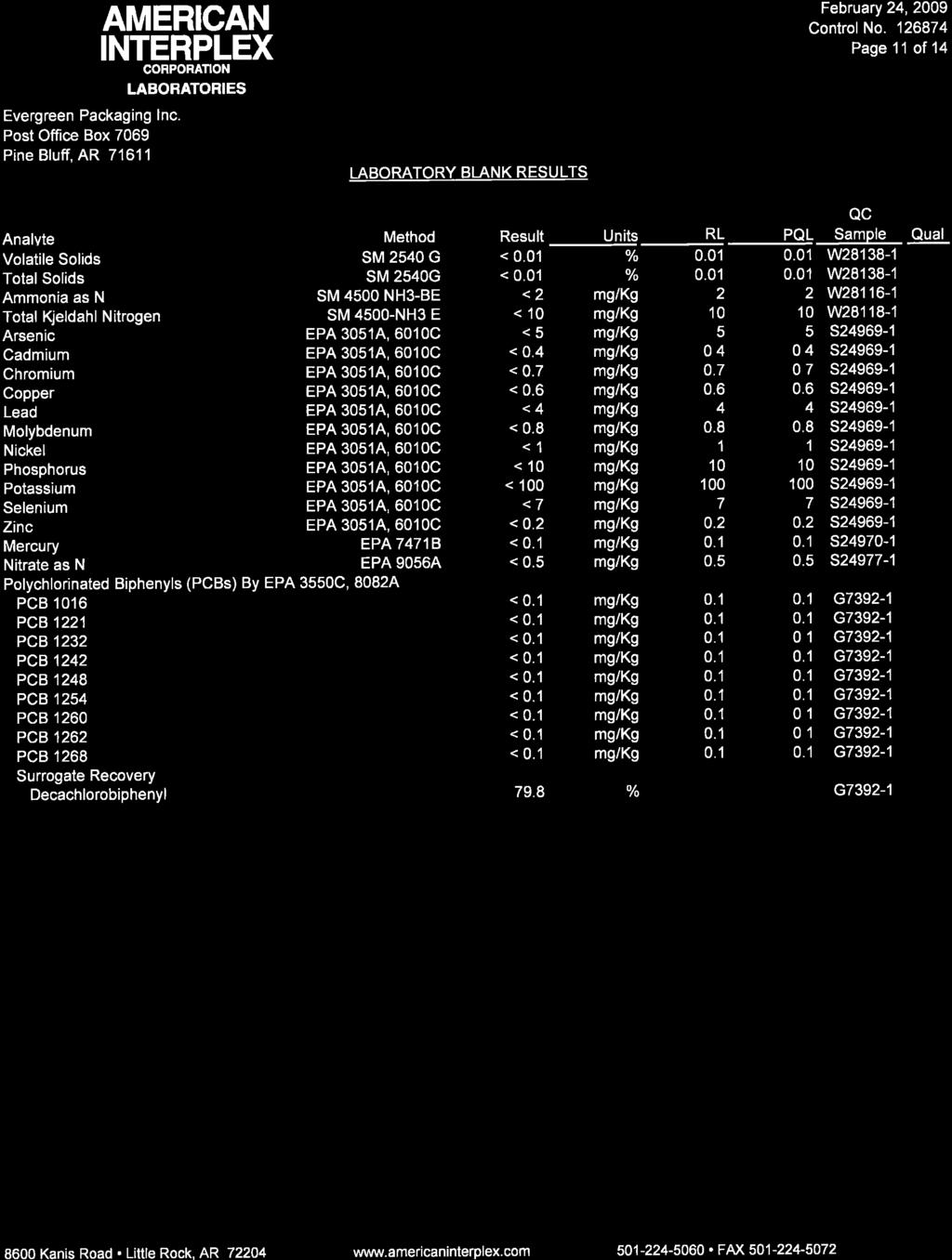
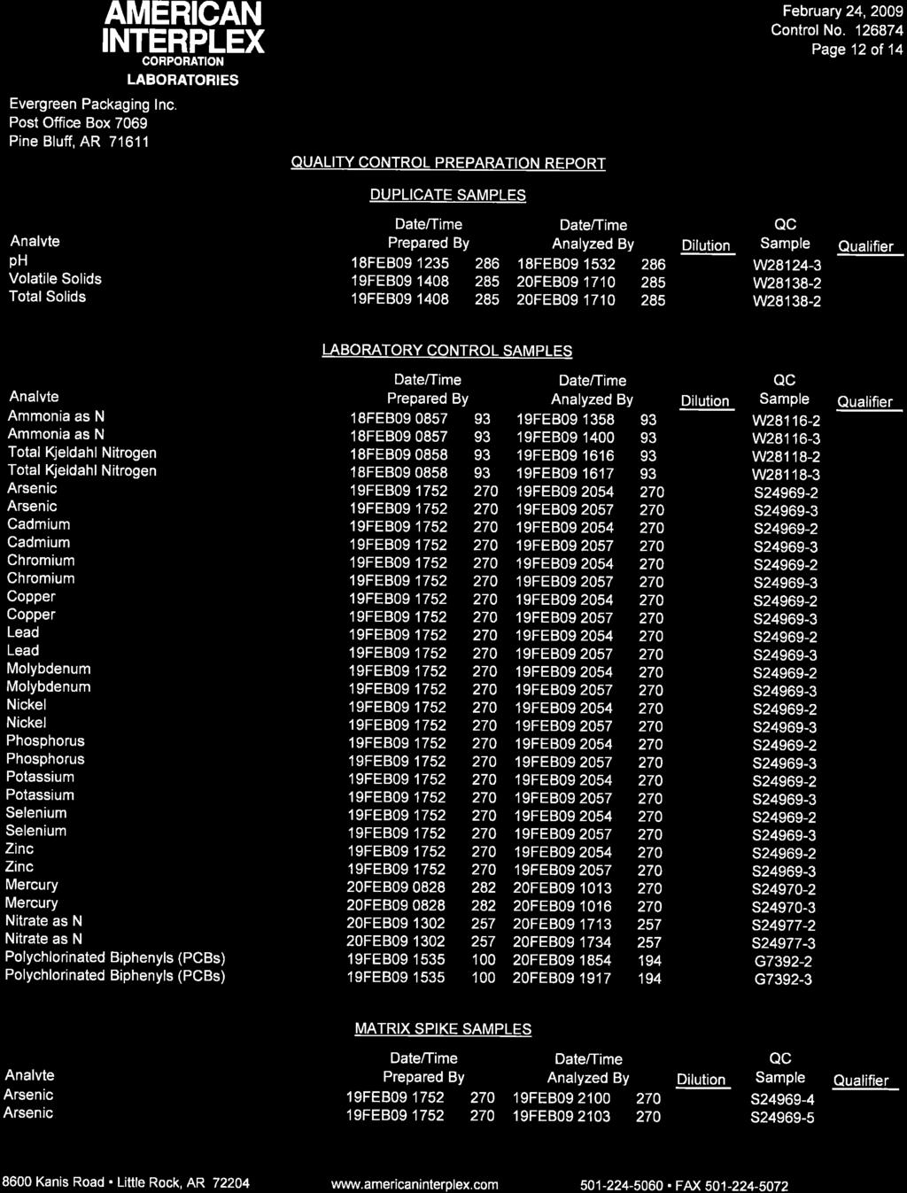
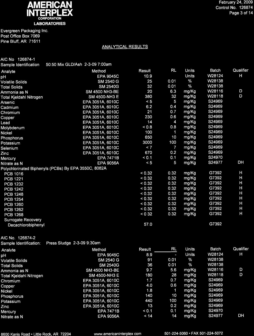
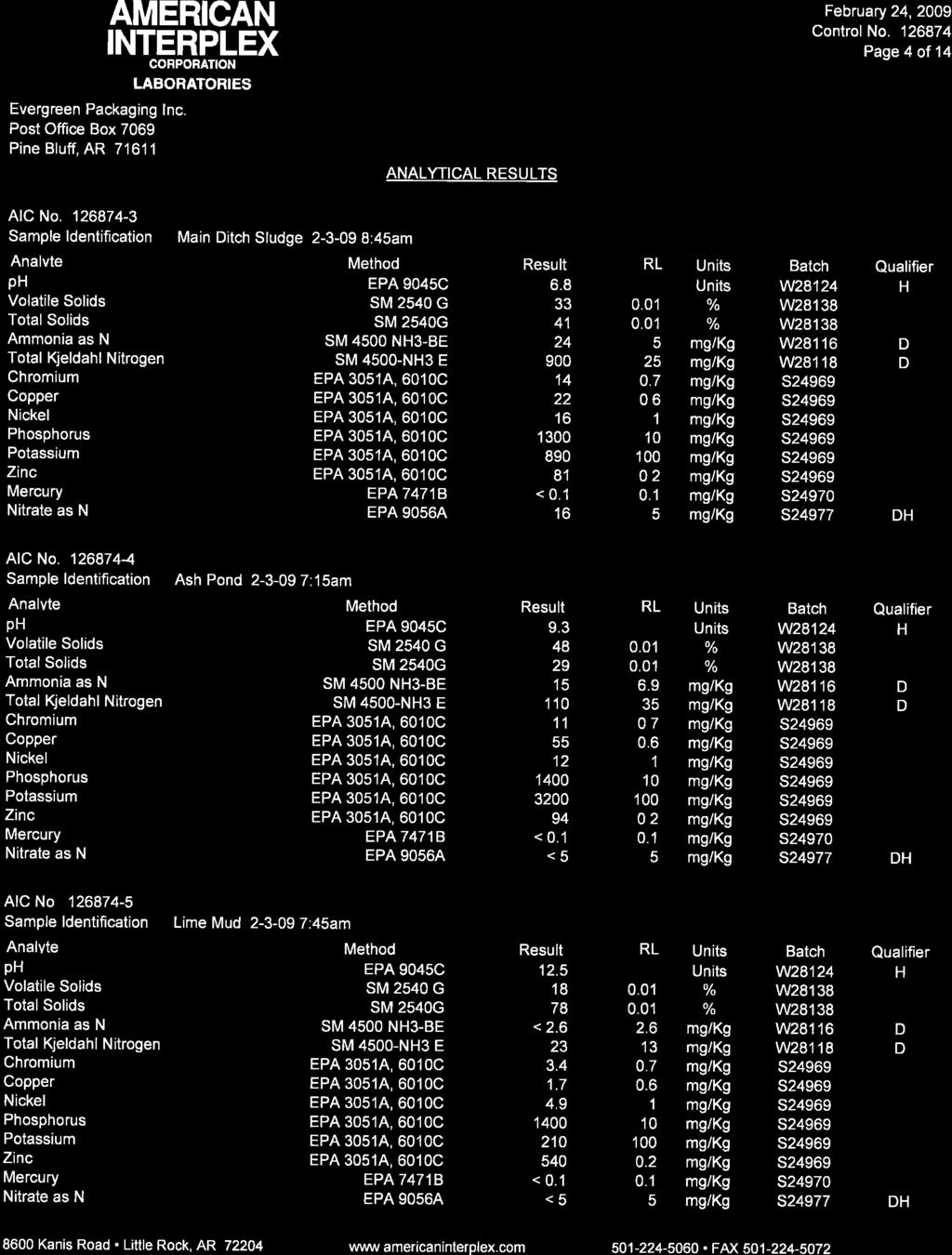
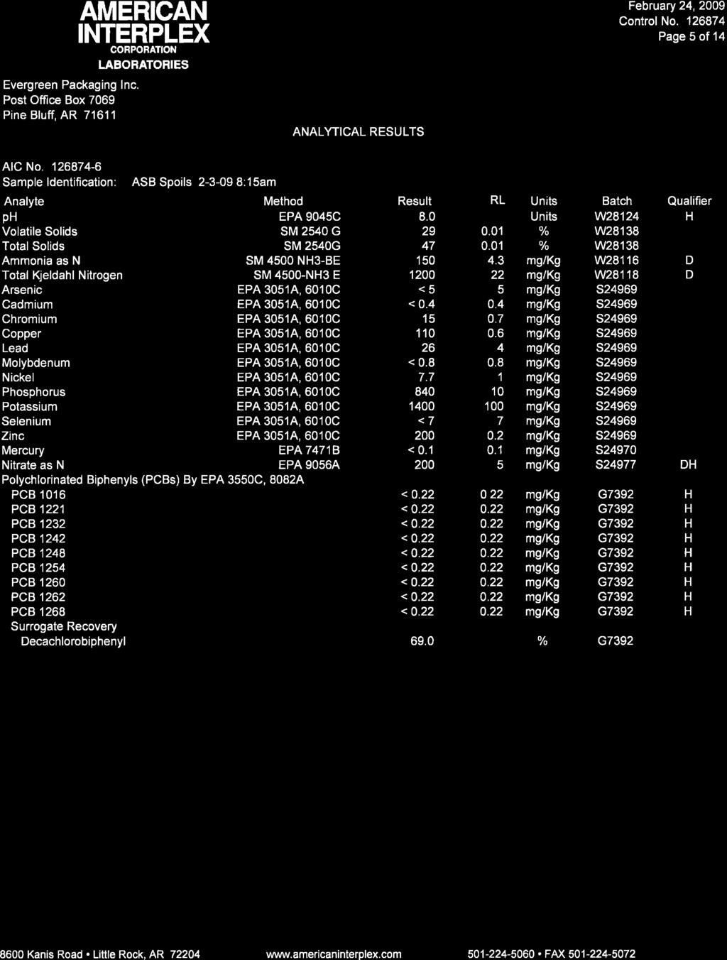
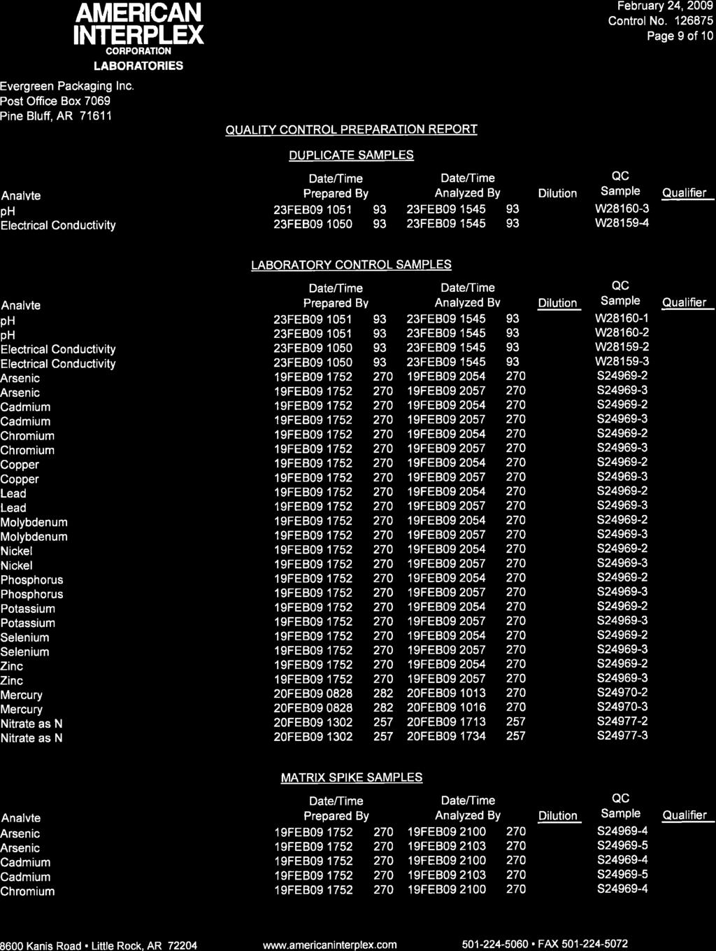
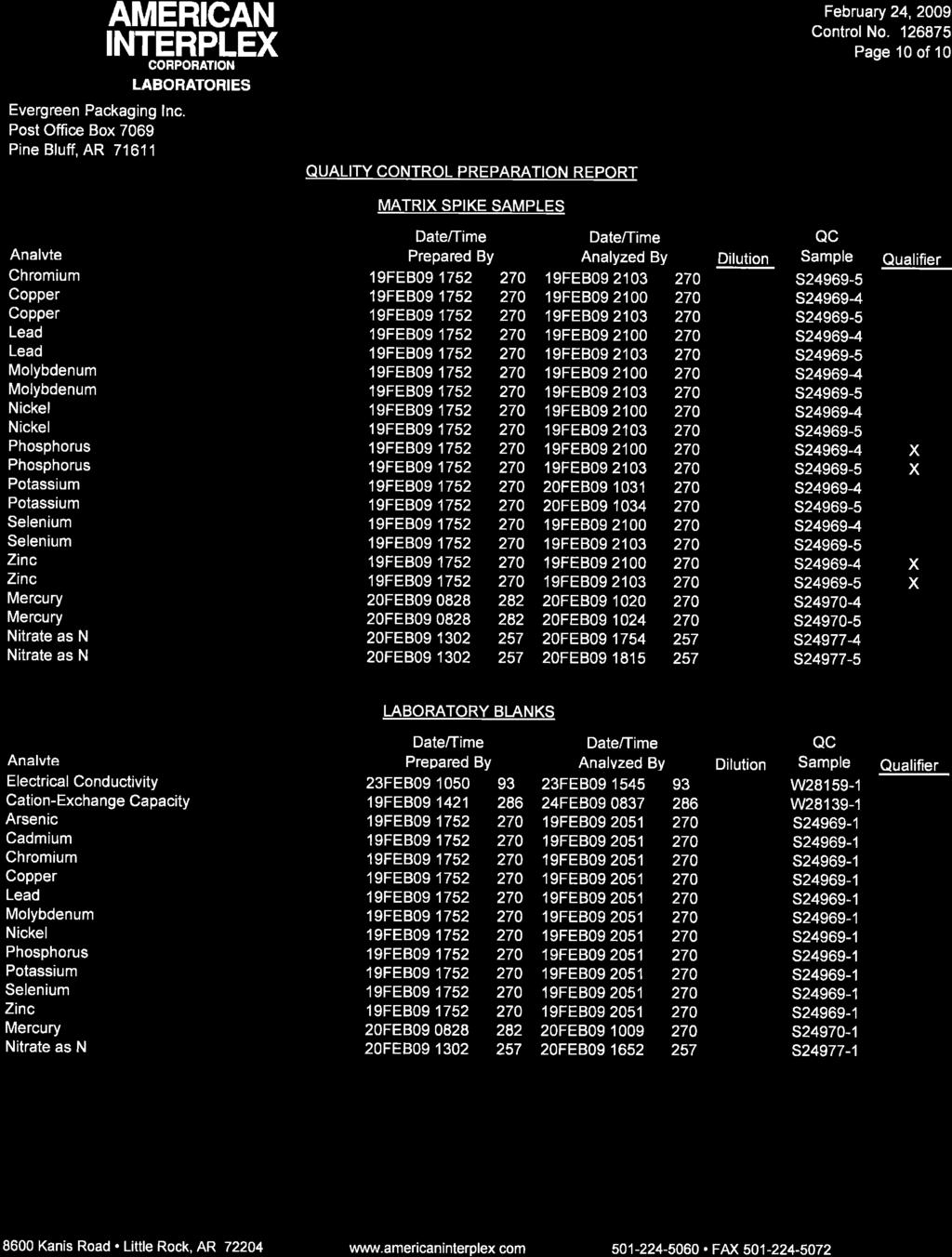
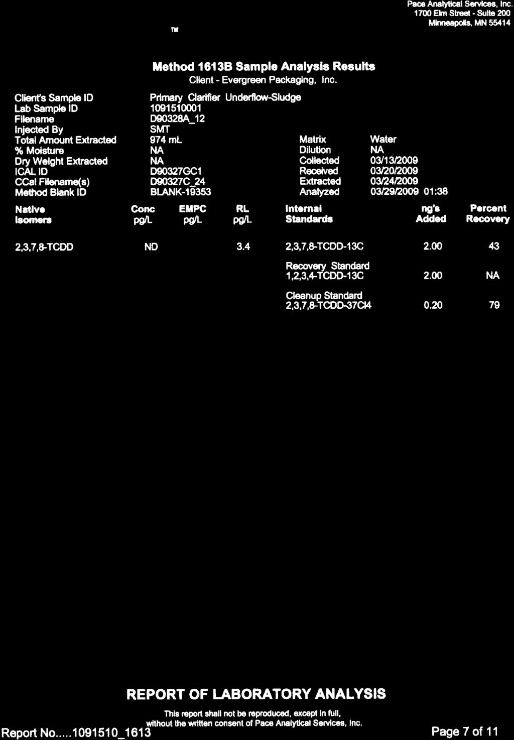
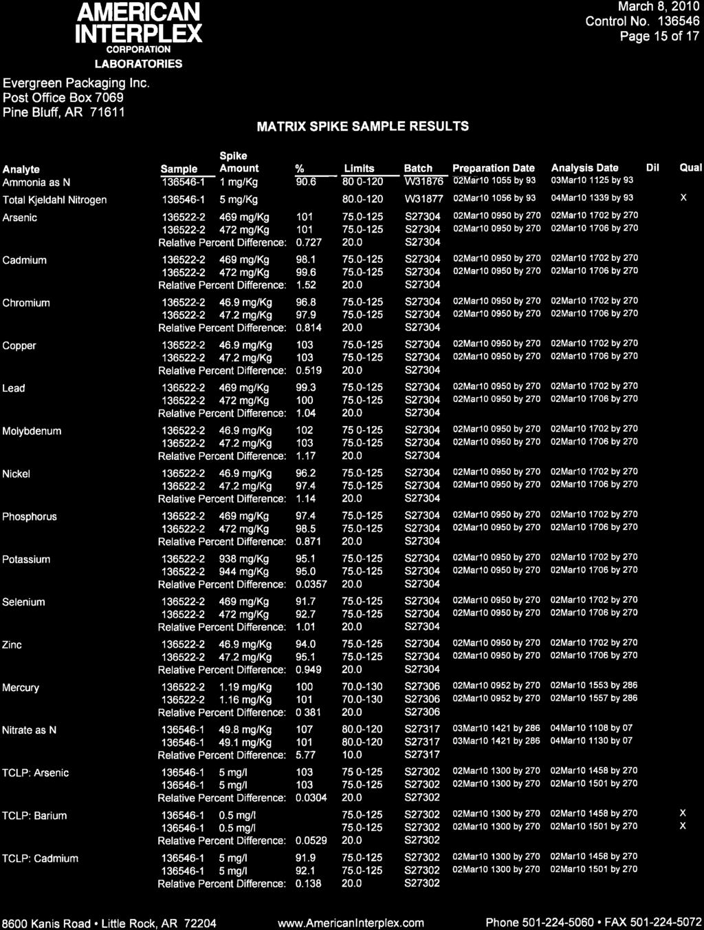
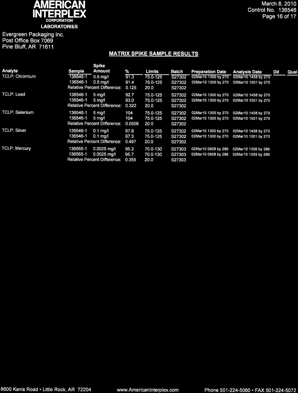
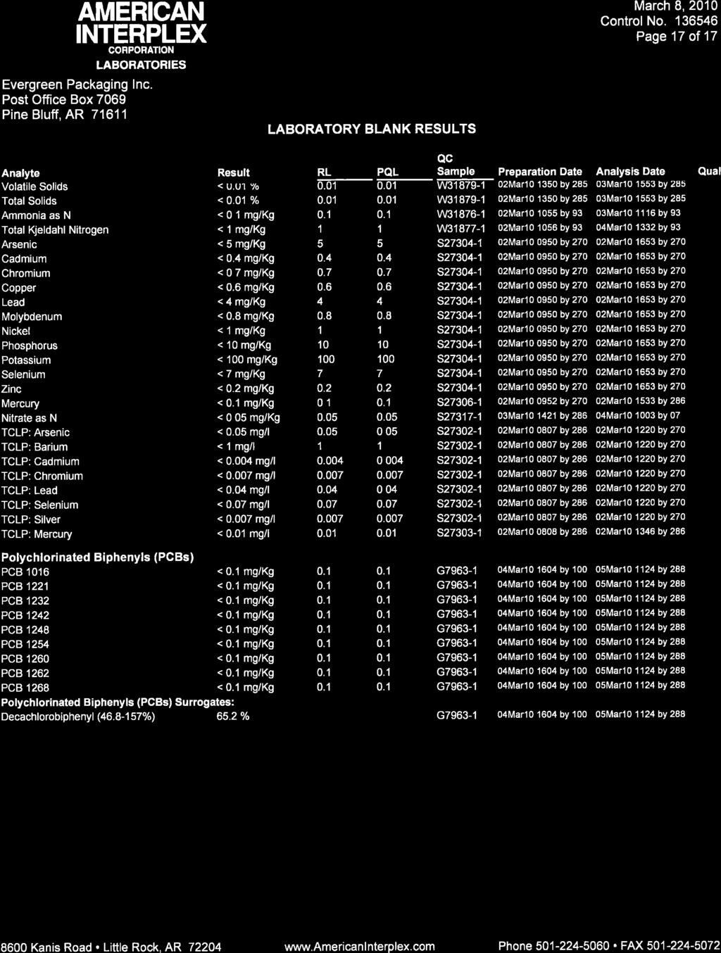
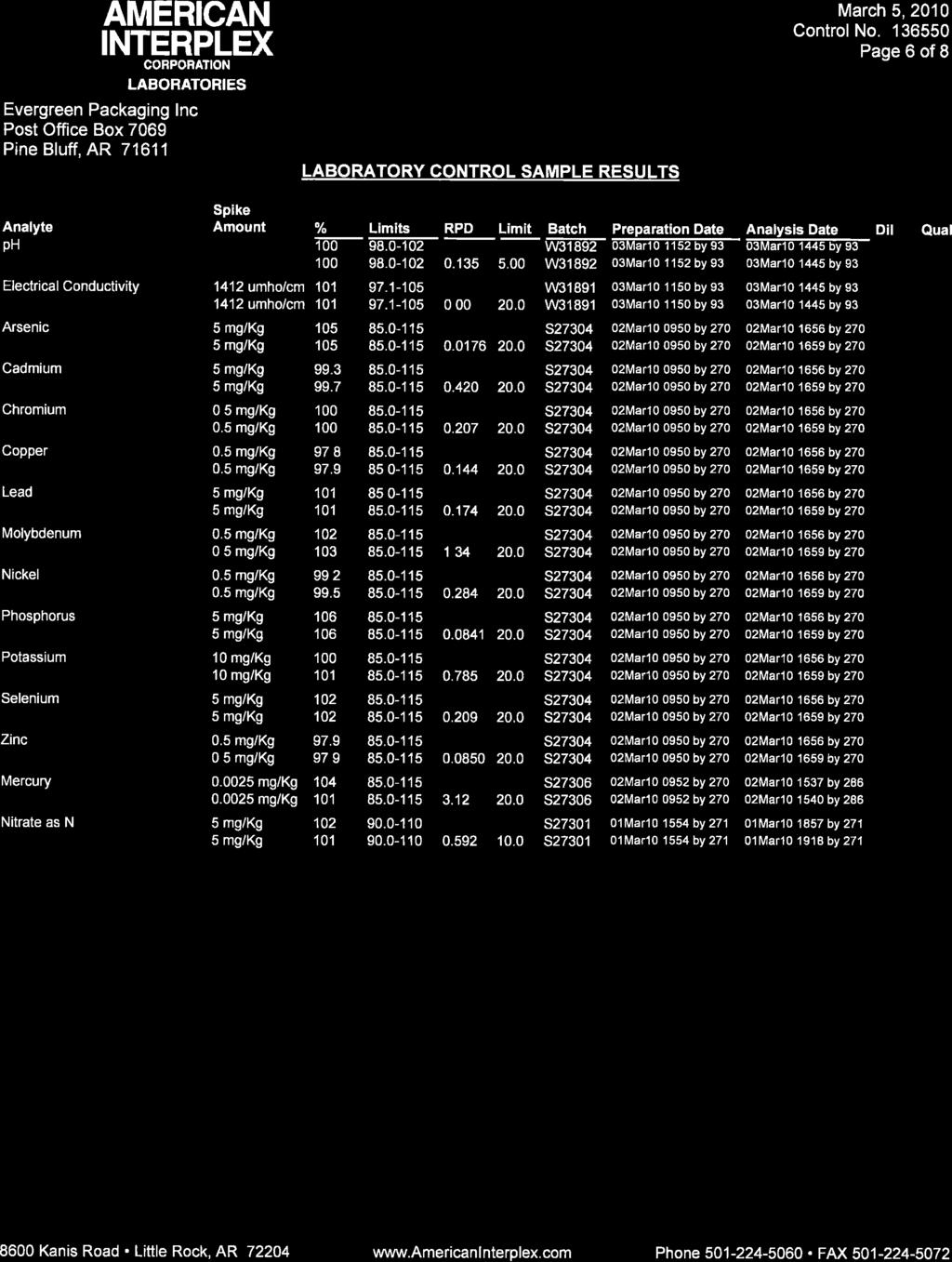
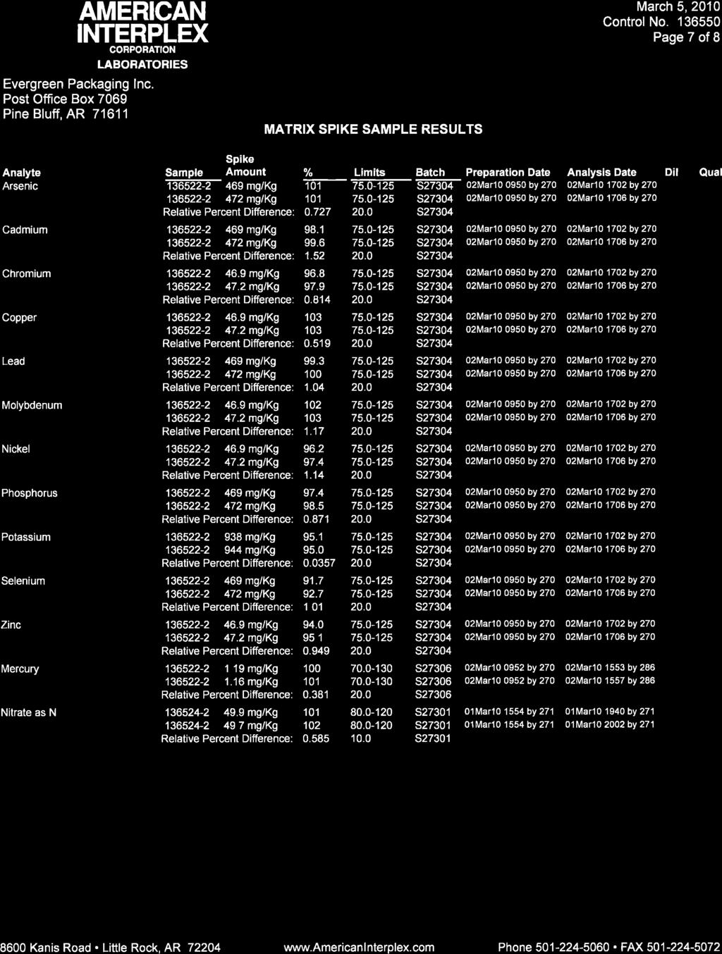
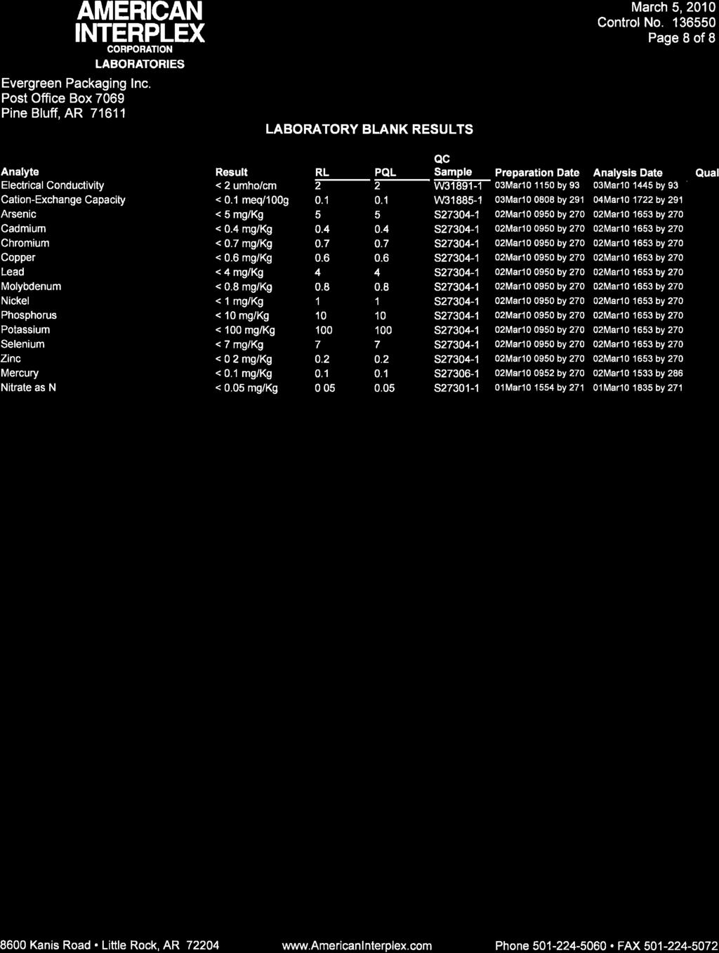
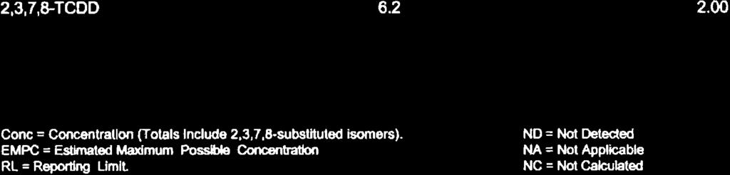
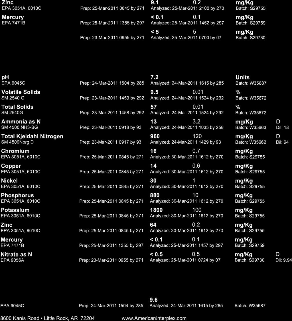
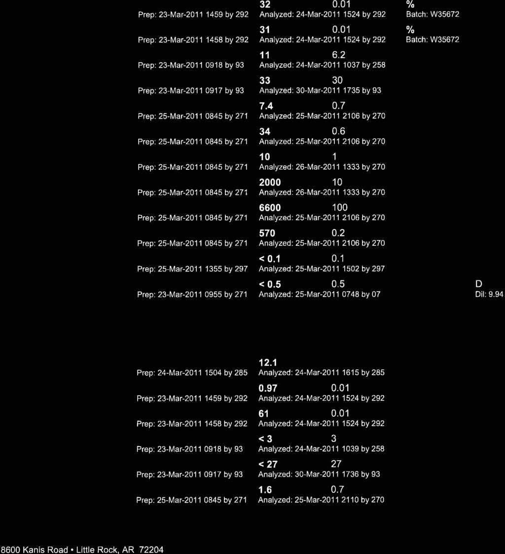
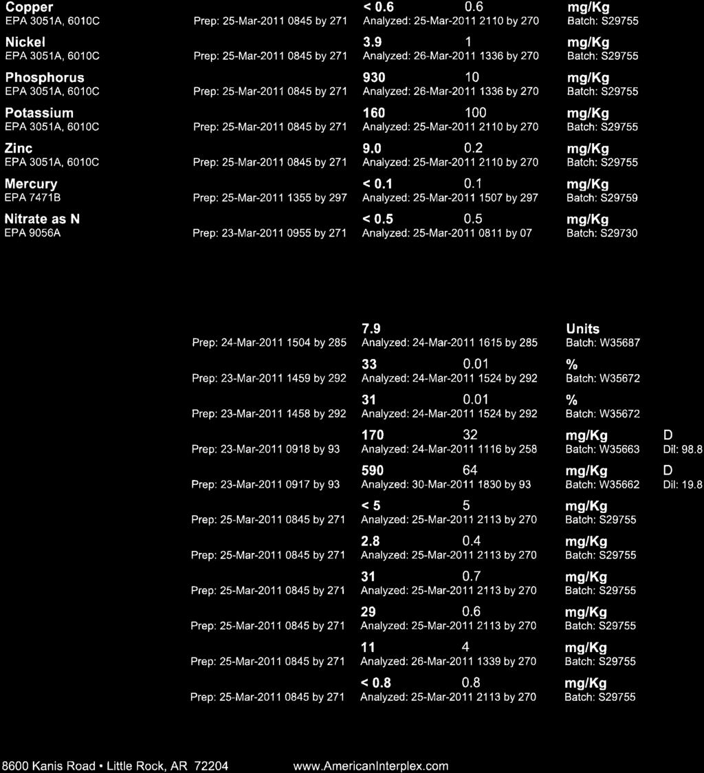
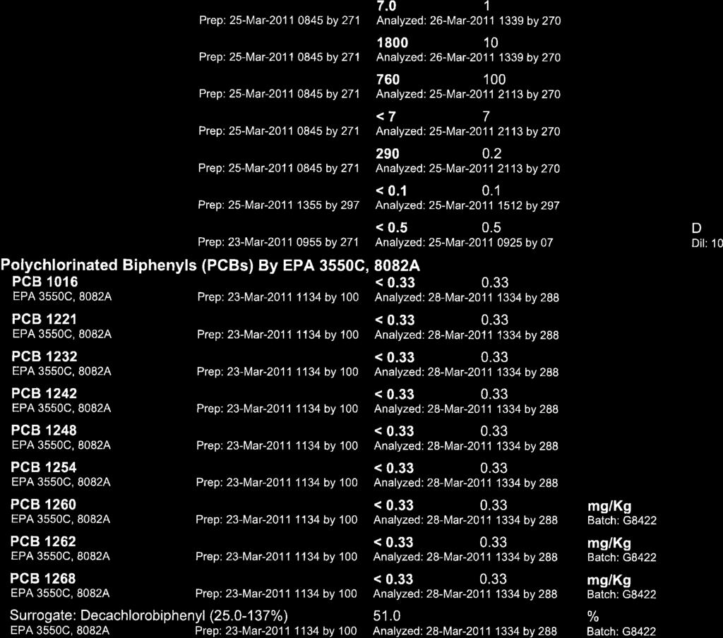
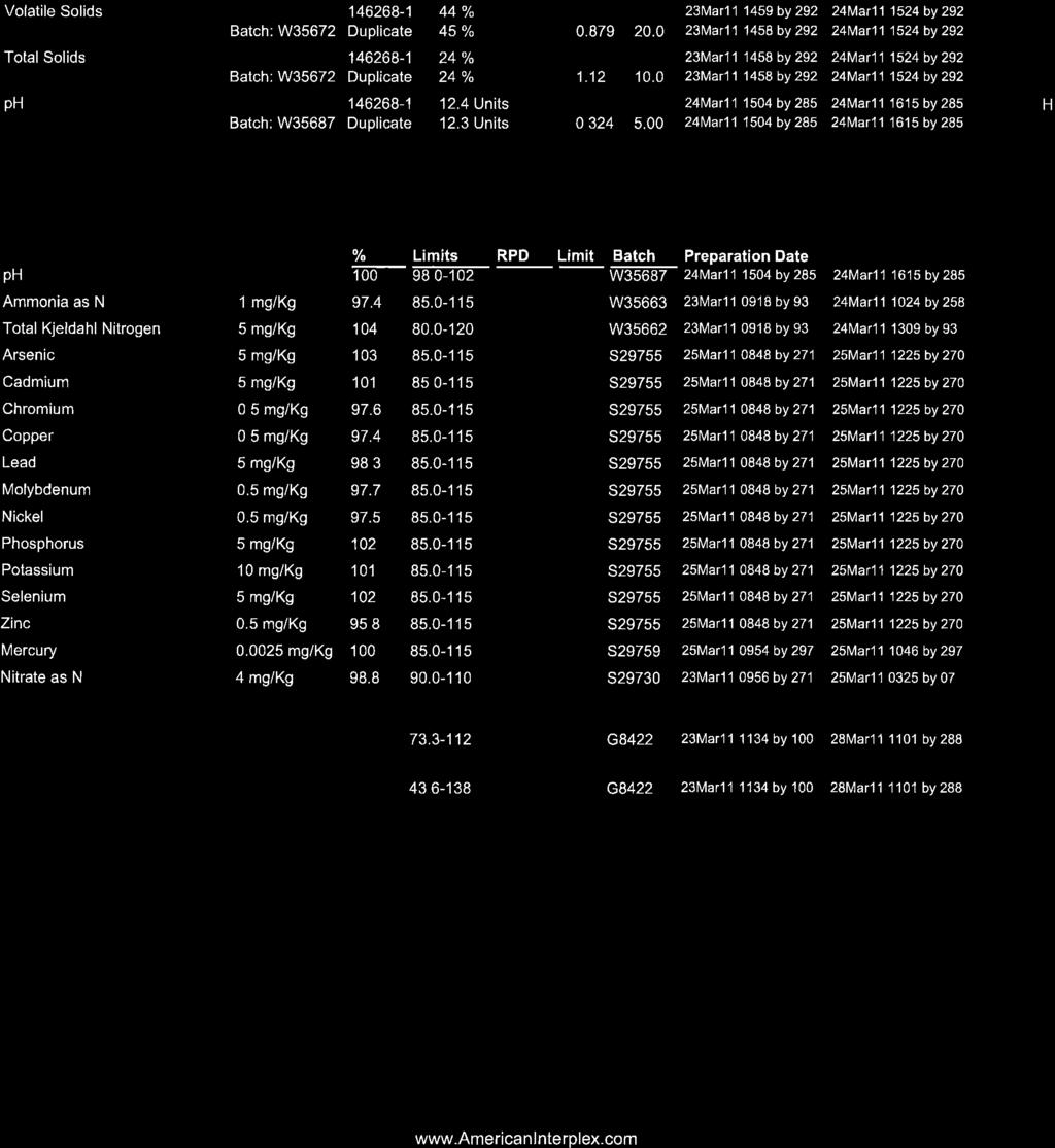
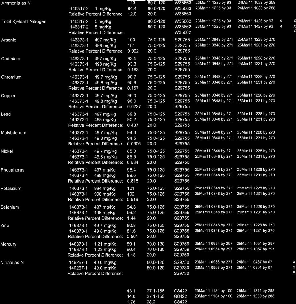
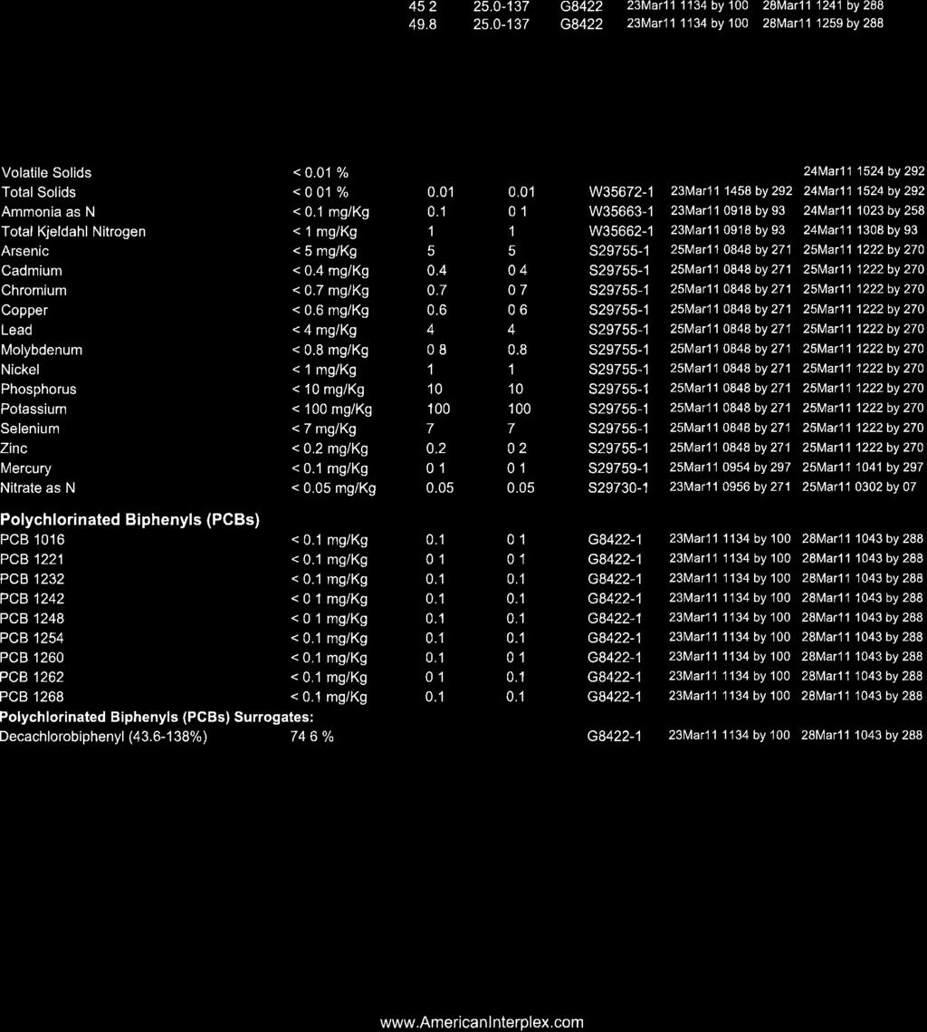
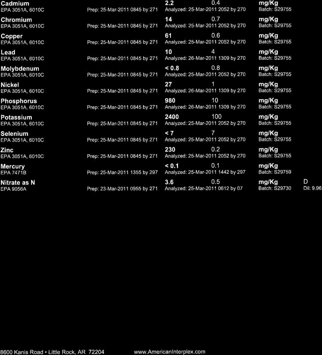
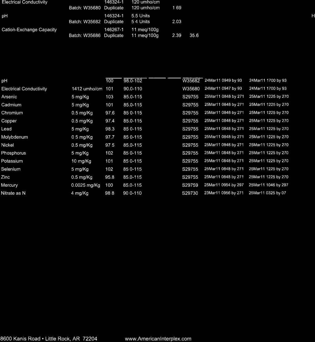
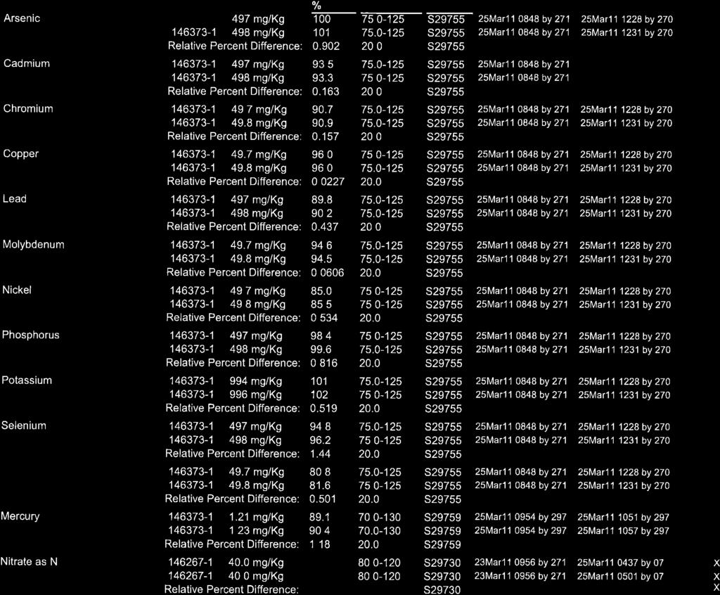
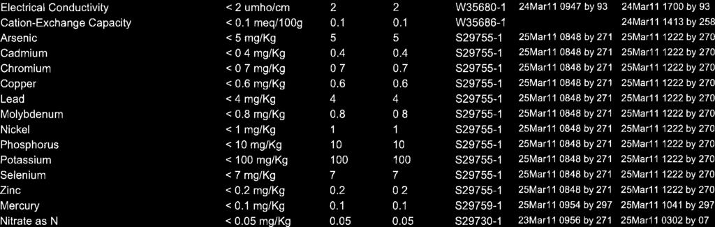
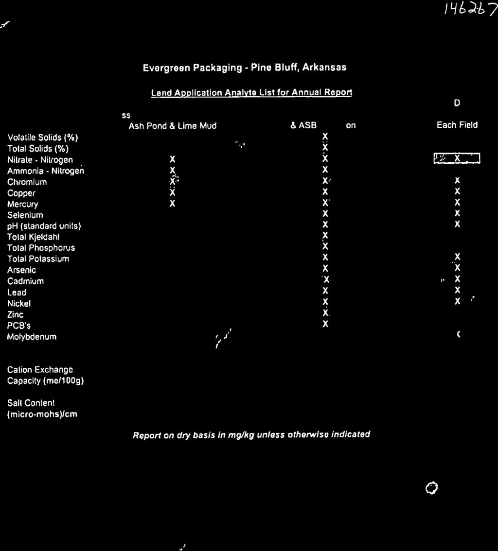
12 5.0 SLUDGE CHARACTERISTICS Table 2 shows a tabulation of the six existing sources that is to be land applied and the average concentration values of analyzed parameters from 2008 to The laboratory data sheets that were used to compile this data have been included in Appendix D of the application. Table 3 provides an estimate of the total sludge PAN based on the data provided in Table 2. These calculations were derived from equations provided in the Guidelines for Land Application of Municipal Sewage Sludge. In accordance with Permit 4579-WR-4 all sludge results are summarized and submitted to ADEQ as part of the annual report. Sludge metals analysis results are evaluated annually for ceiling concentrations and cumulative loading. A comparison is made of the metals concentrations with the ceiling concentrations listed in Table 1 of 40 CFR as required by Permit No WR-4. Additionally, metals are evaluated along with previously land applied sludge analysis results to estimate whether cumulative loading rates are exceeded as required by Permit No WR-4. Should it be determined that either ceiling concentrations or cumulative loading rates are exceeded, land application for the acreage in question will cease. In addition to the parameters listed in Table 2, Evergreen monitors dioxin from the primary clarifier sludge for 2,3,7,8 TCDD. Results of dioxin analysis are summarized and submitted to ADEQ as part of the annual reporting requirements of permit 4579-WR-4. June 29,
13 Table 2. Sludge Waste Analytical Data Average concentration values of Evergreen s sludge sources from 2008 to Parameters Ash Pond Dry Weight Basis Lime Mud Dry Weight Basis Main Ditch Dry Weight Basis ASB Spoils Dry Weight Basis 50:50 GLD/Ash Dry Weight Basis Press Sludge Dry Weight Basis Arsenic, mg/kg Cadmium, mg/kg Chromium mg/kg Copper, mg/kg Lead, mg/kg Mercury, mg/kg Molybdenum, mg/kg Nickel, mg/kg Zinc, mg/kg Selenium, mg/kg TKN, mg/kg Phosphorus, mg/kg Potassium, mg/kg Nitrate-N, mg/kg Ammonia-N, mg/kg % Solids % Volatile Solids ph (su) PCB's mg/kg * Where values were less than the Detection Limit (DL), ½ the detection value was used for calculations. June 29,
14 Table 3. Sludge Analysis - Total plant available nitrogen (PAN), dry basis. Source TKN mg/l Ammonia Nitrogen Total (mg/l) Available (mg/l) Organic Nitrogen Total (mg/l) Available (mg/l) Available Nitrate Nitrogen (mg/l) Total PAN* (lb/mm Gal) Ash Pond Lime Mud Main Ditch ASB Spoils GLD/Ash Press Sludge * PAN = ((0.3 x (TKN - Ammonia)) + (0.5 x Ammonia N) + Nitrite N + Nitrate N)/ LOCATION MAPS A USGS 7.5 minute series topographic map of the Ladd quadrangle and an aerial map of the facility are provided as Figure 2 and Figure 3. The maps display information such as the facility location, approximate facility boundary, adjacent land use, and nearby receiving streams. Figures 3 and 4 also depict application area information such as legal descriptions, field locations, and boundaries. 7.0 SITE MANAGEMENT PLAN The following sections discuss Evergreen s site management for each sludge waste and application areas. Site management information includes soil characteristics of the applied fields, waste application rates, suitable crops for planting, crop requirements, and total acres required for applications. Land application area information is also included in Section 7.3. In addition, sludge loadings are limited in the permit by the following: 1) plant available nitrogen (PAN) of the sludge, which cannot exceed the expected nitrogen uptake of the proposed crop that will be planted, 2) ceiling concentration limits for metals, and 3) cumulative loading rates for metals. June 29,
15 7.1 Waste Application Rate Calculations Several crops are suitable for use in Evergreen s land application areas. Each potential crop was evaluated for sludge application rates using nutrient uptake information (crop nitrogen requirement, CNR) from Table 4-11 of the Process Design Manual for Land Treatment of Municipal Wastewater, USEPA, October Table 4 shows a tabulation of the resulting sludge application rates and the amount of acreage necessary for the various crops based on the PAN calculated in Table 3. Table 5 shows the total acres required for potential crops. These calculations are derived from averaged sludge waste percent solids and average tons applied of each sludge waste from 2008 to Evergreen may elect to apply sludge to fields on a rotating basis. During any non-farm years, natural grasses will be allowed to grow on the soil that is not receiving sludge. Since sludge will not be applied during years the fields are not farmed, the uptake of natural grasses has not been considered in the nutrient uptake calculations for determining acreage requirements. Table 4. Calculated sludge application rates. Crop Crop Nitrogen Requirement (lb/ac-yr) Sludge Application Rate (tons/acre-year) = Crop Nitrogen Requirement (CNR) in (lb/yr) divided by Plant Available Nitrogen (PAN) in (lbs/ton of sludge) 50:50 Ash Lime Mud Main Ditch ASB Spoils Press Sludge GLD/Ash Cotton Bermuda Grass 300 1,505 1, ,046 1,037 Soybeans 223 1,118 1, Sorghum Ryegrass Fescue Corn Wheat June 29,
16 Table 5. Total acres required per sludge product Crop Ash Lime Mud Main Ditch 2,009 Dry Tons/Year Sludge Application Rate 3,962 Dry Tons/Year Sludge Application Rate 2,551 Dry Tons/Year Sludge Application Rate ASB Spoils 3,320 Dry Tons/Year Sludge Application Rate 50:50 GLD/Ash 15,746 Dry Tons/Year Sludge Application Rate Acres Required (Existing Sources) Cotton Bermuda Grass Soybeans Sorghum Ryegrass Fescue Corn Wheat * Press Sludge has not been Land Applied. 7.2 Soil Analysis In accordance with Permit 4579-WR-4 all soil results are summarized and submitted to ADEQ as part of the annual report. Table 6 shows the averaged results of the soils analysis from samples collected from 2008 to 2011 for fields A, D, and E. The remaining fields (B, C, and F) have not been applied to over the past five years and soil data is not available. Soil samples are taken from several locations across a land application field. These soil samples are then mixed and composited to make a single sample for each acre area. The portion of field E located south of the railroad track is not being utilized due to its position in the 100-year flood plain. The remaining five fields contain approximately 459 acres with about 85% (390 acres) of this amount being available for sludge waste application. Current land application areas are located outside the 100-year flood plain according to the Flood Insurance maps (Figure 5) for this area (FEMA Community Panel Number 05069C0325D dated March 16, 2009). June 29,
17 Table 6. Average soil characteristics for fields A, D, and E. Parameters Field A Field D Field E Dry Weight Basis Dry Weight Basis Dry Weight Basis Arsenic, mg/kg Cadmium, mg/kg Chromium mg/kg Copper, mg/kg Lead, mg/kg Mercury, mg/kg < Molybdenum, mg/kg Nickel, mg/kg Nitrate as N, mg/kg Phosphorus, mg/kg Potassium, mg/kg Selenium, mg/kg Sodium mg/kg Zinc, mg/kg CEC, mg-eq/100g Specific Conductance (µs/cm) ph (su) June 29,

18 Figure 5. Flood Insurance Map. June 29,
19 7.3 Application Area Map Information Figure 3 and Figure 4 depict fields A, B, C, D, E, and F locations, boundaries, and legal descriptions. All land application sites are located in Jefferson County. Dominant surrounding land use consists of pasture and crop land. The Arkansas River is the nearest receiving stream. The Arkansas River levee system borders the facility to the northwest. State highway 63 borders the facility to the west and Fairfield Road borders the facility to the south. Pine Bluff, Arkansas is the nearest community and is located approximately 3.5 miles west of the facility. Soil series boundaries, soil map unit names, and soil ratings are for the application areas are provided in the Web Soil Survey figures provided in Appendix B. June 29,
20 Appendix A Arkansas Permit No WR-4
21
22
23
24
25
26
27
28
29
30
31 Appendix B Land Application Soil Information
32 Map Unit Name Jefferson and Lincoln Counties, Arkansas (Evergreen Packaging Field A) 34 14' 21'' 34 14' 7'' ' 28'' 91 54' 28'' Map Scale: 1:3,160 if printed on A size (8.5" x 11") sheet Meters Feet ' 2'' 91 54' 2'' ' 21'' 34 14' 7'' Natural Resources Conservation Service Web Soil Survey National Cooperative Soil Survey 9/28/2011 Page 1 of 3
33 Map Unit Name Jefferson and Lincoln Counties, Arkansas (Evergreen Packaging Field A) MAP LEGEND Area of Interest (AOI) Soils Soil Ratings Political Features Area of Interest (AOI) Soil Map Units Oklared fine sandy loam, occasionally flooded Roxana silt loam, occasionally flooded Not rated or not available Cities Water Features Transportation Streams and Canals Rails Interstate Highways US Routes Major Roads Local Roads MAP INFORMATION Map Scale: 1:3,160 if printed on A size (8.5" 11") sheet. The soil surveys that comprise your AOI were mapped at 1:20,000. Warning: Soil Map may not be valid at this scale. Enlargement of maps beyond the scale of mapping can cause misunderstanding of the detail of mapping and accuracy of soil line placement. The maps do not show the small areas of contrasting soils that could have been shown at a more detailed scale. Please rely on the bar scale on each map sheet for accurate map measurements. Source of Map: Natural Resources Conservation Service Web Soil Survey URL: Coordinate System: UTM Zone 15N NAD83 This product is generated from the USDA-NRCS certified data as of the version date(s) listed below. Soil Survey Area: Jefferson and Lincoln Counties, Arkansas Survey Area Data: Version 8, Dec 2, 2008 Date(s) aerial images were photographed: Data not available. The orthophoto or other base map on which the soil lines were compiled and digitized probably differs from the background imagery displayed on these maps. As a result, some minor shifting of map unit boundaries may be evident. Natural Resources Conservation Service Web Soil Survey National Cooperative Soil Survey 9/28/2011 Page 2 of 3
34 Map Unit Name Jefferson and Lincoln Counties, Arkansas Evergreen Packaging Field A Map Unit Name Map Unit Name Summary by Map Unit Jefferson and Lincoln Counties, Arkansas (AR660) Map unit symbol Map unit name Rating Acres in AOI Percent of AOI 24 Oklared fine sandy loam, occasionally flooded 36 Roxana silt loam, occasionally flooded Oklared fine sandy loam, occasionally flooded Roxana silt loam, occasionally flooded % % Totals for Area of Interest % Description A soil map unit is a collection of soil areas or nonsoil areas (miscellaneous areas) delineated in a soil survey. Each map unit is given a name that uniquely identifies the unit in a particular soil survey area. Rating Options Aggregation Method: No Aggregation Necessary Tie-break Rule: Lower Natural Resources Conservation Service Web Soil Survey National Cooperative Soil Survey 9/28/2011 Page 3 of 3
35 Map Unit Name Jefferson and Lincoln Counties, Arkansas (Evergreen Packaging Field B) 34 14' 49'' 34 14' 26'' ' 57'' 91 55' 57'' Map Scale: 1:3,420 if printed on A size (8.5" x 11") sheet Meters Feet ' 36'' 91 55' 36'' ' 49'' 34 14' 25'' Natural Resources Conservation Service Web Soil Survey National Cooperative Soil Survey 10/14/2011 Page 1 of 3
36 Map Unit Name Jefferson and Lincoln Counties, Arkansas (Evergreen Packaging Field B) MAP LEGEND Area of Interest (AOI) Area of Interest (AOI) Soils Soil Map Units Soil Ratings Coushatta silt loam McGehee silt loam Portland clay Roxana silt loam Yorktown silty clay Not rated or not available Political Features Cities Water Features Streams and Canals Transportation Rails Interstate Highways US Routes Major Roads MAP INFORMATION Map Scale: 1:3,420 if printed on A size (8.5" 11") sheet. The soil surveys that comprise your AOI were mapped at 1:20,000. Warning: Soil Map may not be valid at this scale. Enlargement of maps beyond the scale of mapping can cause misunderstanding of the detail of mapping and accuracy of soil line placement. The maps do not show the small areas of contrasting soils that could have been shown at a more detailed scale. Please rely on the bar scale on each map sheet for accurate map measurements. Source of Map: Natural Resources Conservation Service Web Soil Survey URL: Coordinate System: UTM Zone 15N NAD83 This product is generated from the USDA-NRCS certified data as of the version date(s) listed below. Soil Survey Area: Jefferson and Lincoln Counties, Arkansas Survey Area Data: Version 8, Dec 2, 2008 Date(s) aerial images were photographed: Data not available. The orthophoto or other base map on which the soil lines were compiled and digitized probably differs from the background imagery displayed on these maps. As a result, some minor shifting of map unit boundaries may be evident. Local Roads Natural Resources Conservation Service Web Soil Survey National Cooperative Soil Survey 10/14/2011 Page 2 of 3
37 Map Unit Name Jefferson and Lincoln Counties, Arkansas Evergreen Packaging Field B Map Unit Name Map Unit Name Summary by Map Unit Jefferson and Lincoln Counties, Arkansas (AR660) Map unit symbol Map unit name Rating Acres in AOI Percent of AOI 8 Coushatta silt loam Coushatta silt loam % 22 McGehee silt loam McGehee silt loam % 30 Portland clay Portland clay % 35 Roxana silt loam Roxana silt loam % 51 Yorktown silty clay Yorktown silty clay % Totals for Area of Interest % Description A soil map unit is a collection of soil areas or nonsoil areas (miscellaneous areas) delineated in a soil survey. Each map unit is given a name that uniquely identifies the unit in a particular soil survey area. Rating Options Aggregation Method: No Aggregation Necessary Tie-break Rule: Lower Natural Resources Conservation Service Web Soil Survey National Cooperative Soil Survey 10/14/2011 Page 3 of 3
38 Map Unit Name Jefferson and Lincoln Counties, Arkansas (Evergreen Packaging Field C) 34 13' 37'' 34 13' 8'' ' 51'' 91 55' 50'' Okeefe Rd Map Scale: 1:6,440 if printed on A size (8.5" x 11") sheet. Meters Paper Mill Rd ,400 2,100 Feet Fairfield Rd ' 57'' 91 54' 58'' ' 36'' 34 13' 7'' Natural Resources Conservation Service Web Soil Survey National Cooperative Soil Survey 10/14/2011 Page 1 of 3
39 Map Unit Name Jefferson and Lincoln Counties, Arkansas (Evergreen Packaging Field C) MAP LEGEND Area of Interest (AOI) Soils Soil Ratings Political Features Area of Interest (AOI) Soil Map Units Hebert silt loam Rilla silt loam, 0 to 1 percent slopes Roxana silt loam Not rated or not available Cities Water Features Transportation Streams and Canals Rails Interstate Highways US Routes Major Roads Local Roads MAP INFORMATION Map Scale: 1:6,440 if printed on A size (8.5" 11") sheet. The soil surveys that comprise your AOI were mapped at 1:20,000. Warning: Soil Map may not be valid at this scale. Enlargement of maps beyond the scale of mapping can cause misunderstanding of the detail of mapping and accuracy of soil line placement. The maps do not show the small areas of contrasting soils that could have been shown at a more detailed scale. Please rely on the bar scale on each map sheet for accurate map measurements. Source of Map: Natural Resources Conservation Service Web Soil Survey URL: Coordinate System: UTM Zone 15N NAD83 This product is generated from the USDA-NRCS certified data as of the version date(s) listed below. Soil Survey Area: Jefferson and Lincoln Counties, Arkansas Survey Area Data: Version 8, Dec 2, 2008 Date(s) aerial images were photographed: Data not available. The orthophoto or other base map on which the soil lines were compiled and digitized probably differs from the background imagery displayed on these maps. As a result, some minor shifting of map unit boundaries may be evident. Natural Resources Conservation Service Web Soil Survey National Cooperative Soil Survey 10/14/2011 Page 2 of 3
40 Map Unit Name Jefferson and Lincoln Counties, Arkansas Evergreen Packaging Field C Map Unit Name Map Unit Name Summary by Map Unit Jefferson and Lincoln Counties, Arkansas (AR660) Map unit symbol Map unit name Rating Acres in AOI Percent of AOI 19 Hebert silt loam Hebert silt loam % 33 Rilla silt loam, 0 to 1 percent slopes Rilla silt loam, 0 to 1 percent slopes % 35 Roxana silt loam Roxana silt loam % Totals for Area of Interest % Description A soil map unit is a collection of soil areas or nonsoil areas (miscellaneous areas) delineated in a soil survey. Each map unit is given a name that uniquely identifies the unit in a particular soil survey area. Rating Options Aggregation Method: No Aggregation Necessary Tie-break Rule: Lower Natural Resources Conservation Service Web Soil Survey National Cooperative Soil Survey 10/14/2011 Page 3 of 3
41 Map Unit Name Jefferson and Lincoln Counties, Arkansas (Evergreen Packaging Field D) 34 14' 9'' 34 13' 22'' ' 18'' 91 56' 18'' Paper Mill Rd Map Scale: 1:10,300 if printed on A size (8.5" x 11") sheet Paper Mill Rd Meters Andrews Rd Okeefe Rd ,000 2,000 3,000 Feet ' 54'' 91 54' 53'' ' 8'' 34 13' 21'' Natural Resources Conservation Service Web Soil Survey National Cooperative Soil Survey 10/14/2011 Page 1 of 3
42 Map Unit Name Jefferson and Lincoln Counties, Arkansas (Evergreen Packaging Field D) MAP LEGEND Area of Interest (AOI) Area of Interest (AOI) Soils Soil Map Units Soil Ratings Coushatta silt loam Hebert silt loam Perry clay Portland clay Roxana silt loam Not rated or not available Political Features Cities Water Features Streams and Canals MAP INFORMATION Map Scale: 1:10,300 if printed on A size (8.5" 11") sheet. The soil surveys that comprise your AOI were mapped at 1:20,000. Please rely on the bar scale on each map sheet for accurate map measurements. Source of Map: Natural Resources Conservation Service Web Soil Survey URL: Coordinate System: UTM Zone 15N NAD83 This product is generated from the USDA-NRCS certified data as of the version date(s) listed below. Soil Survey Area: Jefferson and Lincoln Counties, Arkansas Survey Area Data: Version 8, Dec 2, 2008 Date(s) aerial images were photographed: Data not available. The orthophoto or other base map on which the soil lines were compiled and digitized probably differs from the background imagery displayed on these maps. As a result, some minor shifting of map unit boundaries may be evident. Transportation Rails Interstate Highways US Routes Major Roads Local Roads Natural Resources Conservation Service Web Soil Survey National Cooperative Soil Survey 10/14/2011 Page 2 of 3
43 Map Unit Name Jefferson and Lincoln Counties, Arkansas Evergreen Packaging Field D Map Unit Name Map Unit Name Summary by Map Unit Jefferson and Lincoln Counties, Arkansas (AR660) Map unit symbol Map unit name Rating Acres in AOI Percent of AOI 8 Coushatta silt loam Coushatta silt loam % 19 Hebert silt loam Hebert silt loam % 26 Perry clay Perry clay % 30 Portland clay Portland clay % 35 Roxana silt loam Roxana silt loam % Totals for Area of Interest % Description A soil map unit is a collection of soil areas or nonsoil areas (miscellaneous areas) delineated in a soil survey. Each map unit is given a name that uniquely identifies the unit in a particular soil survey area. Rating Options Aggregation Method: No Aggregation Necessary Tie-break Rule: Lower Natural Resources Conservation Service Web Soil Survey National Cooperative Soil Survey 10/14/2011 Page 3 of 3
 sheet.")
44 Celia Rd Map Unit Name Jefferson and Lincoln Counties, Arkansas (Evergreen Packaging Field E) 34 13' 20'' 34 12' 48'' ' 10'' 91 54' 10'' Fairfield Rd Map Scale: 1:4,770 if printed on A size (8.5" x 11") sheet. Meters Feet ' 41'' 91 53' 41'' ' 20'' 34 12' 47'' Natural Resources Conservation Service Web Soil Survey National Cooperative Soil Survey 9/28/2011 Page 1 of 3
45 Map Unit Name Jefferson and Lincoln Counties, Arkansas (Evergreen Packaging Field E) MAP LEGEND Area of Interest (AOI) Soils Soil Ratings Political Features Area of Interest (AOI) Soil Map Units Portland clay Rilla silt loam, 0 to 1 percent slopes Roxana silt loam Wabbaseka-Latanier complex, undulating Not rated or not available Cities Water Features Transportation Streams and Canals Rails Interstate Highways US Routes Major Roads MAP INFORMATION Map Scale: 1:4,770 if printed on A size (8.5" 11") sheet. The soil surveys that comprise your AOI were mapped at 1:20,000. Warning: Soil Map may not be valid at this scale. Enlargement of maps beyond the scale of mapping can cause misunderstanding of the detail of mapping and accuracy of soil line placement. The maps do not show the small areas of contrasting soils that could have been shown at a more detailed scale. Please rely on the bar scale on each map sheet for accurate map measurements. Source of Map: Natural Resources Conservation Service Web Soil Survey URL: Coordinate System: UTM Zone 15N NAD83 This product is generated from the USDA-NRCS certified data as of the version date(s) listed below. Soil Survey Area: Jefferson and Lincoln Counties, Arkansas Survey Area Data: Version 8, Dec 2, 2008 Date(s) aerial images were photographed: Data not available. The orthophoto or other base map on which the soil lines were compiled and digitized probably differs from the background imagery displayed on these maps. As a result, some minor shifting of map unit boundaries may be evident. Local Roads Natural Resources Conservation Service Web Soil Survey National Cooperative Soil Survey 9/28/2011 Page 2 of 3
46 Map Unit Name Jefferson and Lincoln Counties, Arkansas Evergreen Packaging Field E Map Unit Name Map Unit Name Summary by Map Unit Jefferson and Lincoln Counties, Arkansas (AR660) Map unit symbol Map unit name Rating Acres in AOI Percent of AOI 30 Portland clay Portland clay % 33 Rilla silt loam, 0 to 1 percent slopes Rilla silt loam, 0 to 1 percent slopes % 35 Roxana silt loam Roxana silt loam % 49 Wabbaseka-Latanier complex, undulating Wabbaseka-Latanier complex, undulating % Totals for Area of Interest % Description A soil map unit is a collection of soil areas or nonsoil areas (miscellaneous areas) delineated in a soil survey. Each map unit is given a name that uniquely identifies the unit in a particular soil survey area. Rating Options Aggregation Method: No Aggregation Necessary Tie-break Rule: Lower Natural Resources Conservation Service Web Soil Survey National Cooperative Soil Survey 9/28/2011 Page 3 of 3
 sheet.")
47 Map Unit Name Jefferson and Lincoln Counties, Arkansas (Evergreen Packaging Field F) 34 13' 56'' 34 13' 32'' ' 22'' 91 55' 22'' Paper Mill Rd Map Scale: 1:5,260 if printed on A size (8.5" x 11") sheet Meters ,000 1, Feet ' 38'' ' 39'' ' 56'' 34 13' 32'' Natural Resources Conservation Service Web Soil Survey National Cooperative Soil Survey 10/14/2011 Page 1 of 3
48 Map Unit Name Jefferson and Lincoln Counties, Arkansas (Evergreen Packaging Field F) MAP LEGEND Area of Interest (AOI) Area of Interest (AOI) Soils Soil Map Units Soil Ratings Coushatta silt loam Roxana silt loam Water Not rated or not available Political Features Cities Water Features Streams and Canals Transportation Rails Interstate Highways US Routes Major Roads Local Roads MAP INFORMATION Map Scale: 1:5,260 if printed on A size (8.5" 11") sheet. The soil surveys that comprise your AOI were mapped at 1:20,000. Warning: Soil Map may not be valid at this scale. Enlargement of maps beyond the scale of mapping can cause misunderstanding of the detail of mapping and accuracy of soil line placement. The maps do not show the small areas of contrasting soils that could have been shown at a more detailed scale. Please rely on the bar scale on each map sheet for accurate map measurements. Source of Map: Natural Resources Conservation Service Web Soil Survey URL: Coordinate System: UTM Zone 15N NAD83 This product is generated from the USDA-NRCS certified data as of the version date(s) listed below. Soil Survey Area: Jefferson and Lincoln Counties, Arkansas Survey Area Data: Version 8, Dec 2, 2008 Date(s) aerial images were photographed: Data not available. The orthophoto or other base map on which the soil lines were compiled and digitized probably differs from the background imagery displayed on these maps. As a result, some minor shifting of map unit boundaries may be evident. Natural Resources Conservation Service Web Soil Survey National Cooperative Soil Survey 10/14/2011 Page 2 of 3
49 Map Unit Name Jefferson and Lincoln Counties, Arkansas Evergreen Packaging Field F Map Unit Name Map Unit Name Summary by Map Unit Jefferson and Lincoln Counties, Arkansas (AR660) Map unit symbol Map unit name Rating Acres in AOI Percent of AOI 8 Coushatta silt loam Coushatta silt loam % 35 Roxana silt loam Roxana silt loam % 52 Water Water % Totals for Area of Interest % Description A soil map unit is a collection of soil areas or nonsoil areas (miscellaneous areas) delineated in a soil survey. Each map unit is given a name that uniquely identifies the unit in a particular soil survey area. Rating Options Aggregation Method: No Aggregation Necessary Tie-break Rule: Lower Natural Resources Conservation Service Web Soil Survey National Cooperative Soil Survey 10/14/2011 Page 3 of 3
50 Appendix C Soil and Waste Analysis Summary ( )
51 Average Soil Characteristics for Fields A-F Parameter Concentration (mg/kg) Concentration (lb/ton) Fields A (44 acres) Arsenic, mg/kg Cadmium, mg/kg Chromium mg/kg Copper, mg/kg Lead, mg/kg Mercury, mg/kg < 0.10 < Molybdenum, mg/kg Nickel, mg/kg Nitrate-N, mg/kg Phosphorus, mg/kg Potassium, mg/kg 1, Selenium, mg/kg Sodium mg/kg Zinc, mg/kg CEC, mg-eq/100g Specific Conductance (µs/cm) 1, ph (su) Fields D (118 acres) Arsenic, mg/kg Cadmium, mg/kg Chromium mg/kg Copper, mg/kg Lead, mg/kg Mercury, mg/kg < 0.10 < Molybdenum, mg/kg Nickel, mg/kg Nitrate-N, mg/kg Phosphorus, mg/kg Potassium, mg/kg 1, Selenium, mg/kg Sodium mg/kg Zinc, mg/kg CEC, mg-eq/100g Specific Conductance (µs/cm) ph (su) Fields E (64 acres) Arsenic, mg/kg Cadmium, mg/kg Chromium mg/kg Copper, mg/kg Lead, mg/kg Mercury, mg/kg 0.1 < Molybdenum, mg/kg Nickel, mg/kg Nitrate-N, mg/kg Phosphorus, mg/kg Potassium, mg/kg Selenium, mg/kg Sodium mg/kg Zinc, mg/kg CEC, mg-eq/100g Specific Conductance (µs/cm) ph (su)
52 Evergreen Packaging Inc Field Data Summary (Soils) Parameter Field A Field B Field C Field D Field E Field F Dry Weight Basis Dry Weight Basis Dry Weight Basis Dry Weight Basis Dry Weight Basis Dry Weight Basis Arsenic, mg/kg 1.1 Did not apply Cadmium, mg/kg Chromium mg/kg Copper, mg/kg Lead, mg/kg Mercury, mg/kg < < < Molybdenum, mg/kg < < < Nickel, mg/kg *Nitrate as N, mg/kg Phosphorus, mg/kg Potassium, mg/kg Selenium, mg/kg Sodium, mmhos/cm Zinc, mg/kg CEC, mg-eq/100g % Solids Specific Conductance (µs/cm) ph (su) *reported as Nitrates Did not apply Field Data Summary (Soils) Parameter Field A Field B Field C Field D Field E Field F Dry Weight Basis Dry Weight Basis Dry Weight Basis Dry Weight Basis Dry Weight Basis Dry Weight Basis Arsenic, mg/kg <5 2.5 Did not apply <5 2.5 <5 2.5 Did not apply Cadmium, mg/kg < < < Chromium mg/kg Copper, mg/kg Lead, mg/kg <4 2.0 < Mercury, mg/kg < < < Molybdenum, mg/kg < < < Nickel, mg/kg Nitrate as N, mg/kg Phosphorus, mg/kg Potassium, mg/kg Selenium, mg/kg < < < Sodium, mmhos/cm Zinc, mg/kg CEC, mg-eq/100g % Solids Specific Conductance (µs/cm) ph (su)
53 Field Data Summary (Soils) Parameter Field A Field B Field C Field D Field E Field F Dry Weight Basis Dry Weight Basis Dry Weight Basis Dry Weight Basis Dry Weight Basis Dry Weight Basis Arsenic, mg/kg <5 2.5 Did not apply <5 2.5 <5 2.5 Did not apply Cadmium, mg/kg < < < Chromium mg/kg Copper, mg/kg Lead, mg/kg Mercury, mg/kg < < < Molybdenum, mg/kg < < < Nickel, mg/kg Nitrate as N, mg/kg 8.5 < Phosphorus, mg/kg Potassium, mg/kg Selenium, mg/kg < < < Zinc, mg/kg CEC, mg-eq/100g ph Specific Conductance (µs/cm) Field Data Summary (Soils) Parameter Field A Field B Field C Field D Field E Field F Dry Weight Basis Dry Weight Basis Dry Weight Basis Dry Weight Basis Dry Weight Basis Dry Weight Basis Arsenic, mg/kg < Did not apply < < Did not apply Cadmium, mg/kg Chromium mg/kg Copper, mg/kg Lead, mg/kg < Mercury, mg/kg < < < Molybdenum, mg/kg < < < Nickel, mg/kg Nitrate as N, mg/kg < < Phosphorus, mg/kg Potassium, mg/kg Selenium, mg/kg < < < Zinc, mg/kg CEC, mg-eq/100g ph Specific Conductance (µs/cm)
54 Waste Analysis Data Summary Parameters Ash Pond Lime Mud Main Ditch ASB Spoils GLD/Ash Press Sludge Dry Weight Basis Dry Weight Basis Dry Weight Basis Dry Weight Basis Dry Weight Basis Dry Weight Basis Arsenic, mg/kg Cadmium, mg/kg Chromium mg/kg Copper, mg/kg Lead, mg/kg Mercury, mg/kg Molybdenum, mg/kg Nickel, mg/kg Zinc, mg/kg Selenium, mg/kg TKN, mg/kg Phosphorus, mg/kg Potassium, mg/kg Nitrate-N, mg/kg Ammonia-N, mg/kg % Solids % Volatile Solids ph (su) PCB's mg/kg Waste Analysis Data Summary Parameters Ash Pond Lime Mud Main Ditch ASB Spoils GLD/Ash Press Sludge Dry Weight Basis Dry Weight Basis Dry Weight Basis Dry Weight Basis Dry Weight Basis Dry Weight Basis Arsenic, mg/kg Cadmium, mg/kg Chromium mg/kg Copper, mg/kg Lead, mg/kg Mercury, mg/kg Molybdenum, mg/kg Nickel, mg/kg Zinc, mg/kg Selenium, mg/kg TKN, mg/kg Phosphorus, mg/kg Potassium, mg/kg Nitrate-N, mg/kg Ammonia-N, mg/kg % Solids % Volatile Solids ph (su) PCB's mg/kg
55 Waste Analysis Data Summary Parameters Ash Pond Lime Mud Main Ditch ASB Spoils GLD/Ash Press Sludge Dry Weight Basis Dry Weight Basis Dry Weight Basis Dry Weight Basis Dry Weight Basis Dry Weight Basis Arsenic, mg/kg Cadmium, mg/kg Chromium mg/kg Copper, mg/kg Lead, mg/kg Mercury, mg/kg Molybdenum, mg/kg Nickel, mg/kg Zinc, mg/kg Selenium, mg/kg TKN, mg/kg Phosphorus, mg/kg Potassium, mg/kg Nitrate-N, mg/kg Ammonia-N, mg/kg % Solids % Volatile Solids ph (su) PCB's mg/kg Waste Analysis Data Summary Parameters Ash Pond Lime Mud Main Ditch ASB Spoils GLD/Ash Press Sludge Dry Weight Basis Dry Weight Basis Dry Weight Basis Dry Weight Basis Dry Weight Basis Dry Weight Basis Arsenic, mg/kg Cadmium, mg/kg Chromium mg/kg Copper, mg/kg Lead, mg/kg Mercury, mg/kg Molybdenum, mg/kg Nickel, mg/kg Zinc, mg/kg Selenium, mg/kg TKN, mg/kg Phosphorus, mg/kg Potassium, mg/kg Nitrate-N, mg/kg Ammonia-N, mg/kg % Solids % Volatile Solids ph (su) PCB's mg/kg
56 Evergreen Packaging Cubic Yards per Year (wet) Data Pulled from Land App - BeneficialUse.xls in each year's Annual Report Folder Year CY (Cubic Yards) Applied* Ash Lime Main Ditch ASB GLD/Ash ,472 2,628 31, , ,880 5,880 13,300 41,080 Average 5,880 5,880 5,472 7,964 45,532 Average (tons) 5,994 5,994 5,578 8,118 46,414 * Used CY = Tons * Location % Solids CY/yr (wet) Ton/yr (wet) Gallon/yr (wet) CY/yr (dry) Tons/yr (dry) Ash 33.5% 5,880 5,994 1,187,760 1,971 2,009 Lime Mud 66.1% 5,880 5,994 1,187,760 3,887 3,962 Main Ditch 45.7% 5,472 5,578 1,105,344 2,502 2,551 ASB Spoils 40.9% 7,964 8,118 1,608,728 3,257 3,320 GLD/Ash 33.9% 45,532 46,414 9,197,397 15,447 15,746
57 Appendix D Historical Analytical Data ( )
58
59
60
61
62
63
64
65
66
67
68
69
70
71
72
73
74
75
76
77
78
79
80
81
82
83
84
85
86
87
88
89
90
91
92
93
94
95
96
97
98
99
100
101
102
103
104
105
106
107
108
109
110
111
112
113
114
115
116
117
118
119
120
121
122
123

124

125
126
127
128
129
130
131
132
133
134
135
136
137
138
139
140
141
142
143
144
145
146
147
148

149
150
151

152
153
154
155
156
157
158
159
160
161
162
163
164
165

166
167
168

169
170
171
172 Blevins, Terri From: Sent: To: Subject: Attachments: Ungerank, Ralph Tuesday, July 03, :11 AM Blevins, Terri 4579-WR-5 Revised WMP Revised_WMP_ pdf Can you put this on the web? Colby Ungerank Engineer ADEQ, Water Division 5301 Northshore Drive North Little Rock, AR
Hydric Rating by Map Unit Harrison County, Mississippi 30 27' 27'' 30 26' 57''
 Hydric Rating by Map Unit Harrison County, Mississippi 30 27' 27'' 30 26' 57'' 3370400 3370500 3370600 3370700 3370800 3370900 3371000 3371100 3371200 89 2' 40'' 89 2' 41'' 303700 303700 303800 303800
Web Soil Survey National Cooperative Soil Survey
 121 52' 18'' W Irrigated Capability Class Sutter County, California () 121 51' 49'' W 597600 597700 597800 597900 598000 598100 598200 39 6' 27'' N 39 6' 27'' N 39 5' 57'' N 4328400 4328500 4328600 4328700
Web Soil Survey National Cooperative Soil Survey
 122 14' 27'' W () 122 13' 37'' W 40 8' 40'' N 564700 564800 564900 565000 565100 565200 565300 565400 565500 565600 565700 565800 40 8' 40'' N 4443400 4443500 4443600 4443700 4443800 4443900 4444000 4443400
Hydric Rating by Map Unit Harrison County, Mississippi
 89 6' 12'' W 89 5' 54'' W 30 28' 47'' N 30 28' 26'' N 3373210 3373290 3373370 3373450 3373530 3373610 3373690 3373770 3373850 298080 298160 298240 298320 298400 298480 298560 30 28' 47'' N Soil Map may
Custom Soil Resource Report Soil Map
 78 10' 44'' W Custom Soil Resource Report Soil Map 78 9' 40'' W 40 37' 18'' N 738700 738800 738900 739000 739100 739200 739300 739400 739500 739600 739700 739800 739900 740000 740100 40 37' 18'' N 4499700
Hydric Rating by Map Unit Harrison County, Mississippi. Web Soil Survey National Cooperative Soil Survey
 89 9' 7'' W 89 8' 38'' W 30 34' 13'' N 30 33' 57'' N 3383480 3383560 3383640 3383720 3383800 3383880 3383960 293640 293720 293800 293880 293960 294040 294120 294200 294280 294360 3383480 3383560 3383640
Web Soil Survey National Cooperative Soil Survey
 252500 252600 252700 252800 252900 253000 253100 83 47' 15'' W 83 47' 49'' W Nonirrigated Capability Class Jackson and Owsley Counties, Kentucky (Peggy Wilson Booneville Property - ) 253200 253300 37 25'
Soil Map Boulder County Area, Colorado (Planet Blue Grass) Web Soil Survey National Cooperative Soil Survey
 Web Soil Survey National Cooperative Soil Survey") 475910 476000 476090 476180 476270 476360 105 16' 21'' W 476450 476540 476630 476720 476810 4453350 4453440 4453260 4453350 4453170 4453260 4453080 4453170 4453080 475820 475910 4452990 476000 476090 476180
475910 476000 476090 476180 476270 476360 105 16' 21'' W 476450 476540 476630 476720 476810 4453350 4453440 4453260 4453350 4453170 4453260 4453080 4453170 4453080 475820 475910 4452990 476000 476090 476180
T his map is for illus trative purpos es only and does not repres ent a s urvey. I t is provided 'as is ' without warranty or any repres entation of
 http://montgomerytx.mygisonline.com/print/?extent=2988061.71355584,14087737.6935746,299... 3/2/2017 10:41 AM 20 Montgomery CAD, TX Date Printed: 3 /2 /2017 T his map is for illus trative purpos es only
Custom Soil Resource Report. Soil Map. Map projection: Web Mercator Corner coordinates: WGS84 Edge tics: UTM Zone 14N WGS84. Feet.
 Custom Soil Resource Report Soil Map 3188500 3188700 3188900 3189100 3189300 3189500 3189700 96 43' 30'' W 3188500 3188700 3188900 3189100 3189300 3189500 3189700 96 42' 11'' W 28 48' 59'' N 28 48' 59''
CALIFORNIA AGRICULTURAL PR OPERTIES, IN C. GALE RANCH
 CALIFORNIA AGRICULTURAL PR OPERTIES, IN C. GALE RANCH LOCATION: The Ranch is located 6 Yi miles west of the City of Davis on the northwest corner of County Roads 29A and 92E in Yolo County. SIZE: 368.64
Hydric Rating by Map Unit Ocean County, New Jersey (Larsen & N New Prospect Jackson Twp., NJ)
") 74 16' 14'' W Hydric Rating by Map Unit Ocean County, New Jersey ( ) 74 15' 50'' W 40 9' 17'' N 40 8' 53'' N 4444460 4444550 4444640 4444730 4444820 4444910 4445000 4445090 4445180 562120 562210 562300
74 16' 14'' W Hydric Rating by Map Unit Ocean County, New Jersey ( ) 74 15' 50'' W 40 9' 17'' N 40 8' 53'' N 4444460 4444550 4444640 4444730 4444820 4444910 4445000 4445090 4445180 562120 562210 562300
Producing Chandler Walnut Orchard
 AG-LAND Investment Brokers 275 Sale Lane Red Bluff, CA 96080 530-529-4400 Fax 530-527-5042 Producing Chandler Walnut Orchard West Sacramento Avenue - Chico, CA AG-LAND INVESTMENT BROKERS 275 Sale Lane
Cripps Ranch 76+/- Acres Orchard Development Opportunity Dixon, CA. Presented By:
 Cripps Ranch 76+/- Acres Orchard Development Opportunity Dixon, CA Presented By: Cripps Ranch 76+/- Acres Orchard Development Opportunity Dixon, CA Location: This property is located at 5663 Dally Road
Custom Soil Resource Report for Victoria County, Texas
 United States Department of Agriculture Natural Resources Conservation Service A product of the National Cooperative Soil Survey, a joint effort of the United States Department of Agriculture and other
² 2015 Program Year. Farm Tract McLeod County, Minnesota 1:4, NHEL NHEL
 United States Department of Agriculture McLeod County, Minnesota Farm 5125 #* 2 3.65 NHEL Tract 2762 1 33.19 NHEL ² 2015 Program Year Map Created November 06, 2014 Common Land Unit Cropland Non-cropland
Wright County, MN. Overview. Legend
 Wright County, MN Overview 461 ft Legend Roads CSAHCL CTYCL MUNICL PRIVATECL TWPCL Highways Interstate State Hwy US Hwy City/Township Limits c t Subdivisions Parcels Water 2' Contours 842; 844; 846; 848;
Appendix 2b. NRCS Soil Survey
 Appendix 2b NRCS Soil Survey 118 19' 25'' W Nonirrigated Capability Class Antelope Valley Area, California (Del Sur Solar Site) 118 17' 28'' W 378900 379200 379500 379800 380100 380400 380700 381000 381300
CRUM RANCH AREA MAP YOLO COUNTY, California, AC +/-
 CRUM RANCH AREA MAP YOLO COUNTY, California, 235.59 AC +/- Map data 2016 Google Imagery 2016, CAPCOG, DigitalGlobe, Texas Orthoimagery Program, U.S. Geological Survey, USDA Farm Service Agency Boundary
BUNCOMBE COUNTY NORTH CAROLINA
 PROJECT SITE ² 0 0. 75 1. 5 LOCATION MAP MARCH 2018 2. 25 3 Mil es AID: PROJECT # 2018-01122 18.05301 Sheet 1 of 7 Sources: Esri, HERE, DeLorme, USGS, Intermap, INCREMENT P, NRCan, Esri Japan, METI, Esri
Soil Map Polk County, Florida
 Soil Map Polk County, Florida 28 9' 21'' 28 8' 23'' 3113000 3113200 3113400 3113600 3113800 3114000 3114200 3114400 3114600 81 51' 19'' 81 51' 19'' 416000 416000 ± 416200 416200 68 416400 68 416400 7 13
Web Soil Survey National Cooperative Soil Survey
 95 40' 40'' W 95 40' 0'' W 38 44' 27'' N 4290200 4290300 4290400 4290500 4290600 4290700 4290800 4290900 4291000 4291100 4291200 4291300 4291400 267300 267400 267500 267600 267700 267800 267900 268000
Soil Taxonomy Classification Osage County, Kansas. Web Soil Survey National Cooperative Soil Survey
 95 45' 5'' W Soil Taxonomy Classification Osage County, Kansas 95 44' 3'' W 260300 260400 260500 260600 260700 260800 260900 261000 261100 261200 261300 261400 261500 261600 261700 38 33' 4'' N 38 32'
Web Soil Survey National Cooperative Soil Survey
 95 30' 19'' W Soil Taxonomy Classification Franklin County, Kansas 95 29' 28'' W 38 33' 8'' N 281700 281800 281900 282000 282100 282200 282300 282400 282500 282600 282700 282800 282900 38 33' 8'' N 4269300
Web Soil Survey National Cooperative Soil Survey
 95 27' 24'' W Soil Taxonomy Classification Franklin County, Kansas 95 26' 23'' W 285800 285900 286000 286100 286200 286300 286400 286500 286600 286700 286800 286900 287000 287100 287200 38 29' 34'' N 38
Custom Soil Resource Report Soil Map
 121 3' 56'' W Custom Soil Resource Report Soil Map 121 2' 49'' W 45 16' 39'' N 5013800 5014000 5014200 5014400 5014600 5014800 5015000 5015200 5015400 5015600 651800 652000 652200 652400 652600 652800
Exhibit RMP-4. Foote Creek Geology and Topography
 Exhibit RMP-4 Foote Creek Geology and Topography Memorandum To: From: CC: Travis Brown, PacifiCorp Daria Drago, P.E., PMP Dr. Deb Luchsinger Date: January 9, 2019 Re: Foote Creek Rim 1 - Geologic Conditions
FOR SALE. Features Rives Road Petersburg, Virginia Chris Jenkins
 FOR SALE 3513 Rives Road Petersburg, Virginia 23805 Chris Jenkins T 804-228-4928 E cjenkins@ commonwealthcommercial.com Bill Barnett T 804-433-1821 E bbarnett@ commonwealthcommercial.com Features 142±
Custom Soil Resource Report for Forrest County, Mississippi
 United States Department of Agriculture Natural Resources Conservation Service A product of the National Cooperative Soil Survey, a joint effort of the United States Department of Agriculture and other
RANCHO de DOS PALMAS DAVIS, California, AC +/-
 RANCHO de DOS PALMAS DAVIS, California, 507.28 AC +/- Boundary Transmission Line Pond / Tank Well SCOTT STONE P: (530) 662-4094 sastone57@gmail.com 37874 County Road 28, Woodland, Ca. 95695 The information
Soil Taxonomy Classification Jackson County, Florida (Chipola River) Web Soil Survey National Cooperative Soil Survey
 Web Soil Survey National Cooperative Soil Survey") 85 10' 20'' W Soil Taxonomy Classification Jackson County, Florida () 85 9' 8'' W 30 37' 42'' N 30 37' 42'' N 30 37' 2'' N 30 37' 2'' N 85 10' 20'' W N Map Scale: 1:8,740 if printed on A landscape (11"
85 10' 20'' W Soil Taxonomy Classification Jackson County, Florida () 85 9' 8'' W 30 37' 42'' N 30 37' 42'' N 30 37' 2'' N 30 37' 2'' N 85 10' 20'' W N Map Scale: 1:8,740 if printed on A landscape (11"
Carrick Road $798,000
 1955-2020 Carrick Road 165.76± acres Fayette/Scott Counties $798,000 Offered Exclusively By: Zach Davis Principal Broker +1.859.576.8195 www.kirkfarms.com zach@kirkfarms.com Measuring an appx. 165+/- acres,
Soil Taxonomy Classification Washington County, Florida (Pine Log 631A)
") 85 54' 36'' W Soil Taxonomy Classification Washington County, Florida () 85 53' 22'' W 30 25' 42'' N 30 25' 42'' N 30 24' 17'' N 30 24' 17'' N 85 54' 36'' W N Map Scale: 1:12,700 if printed on A portrait
85 54' 36'' W Soil Taxonomy Classification Washington County, Florida () 85 53' 22'' W 30 25' 42'' N 30 25' 42'' N 30 24' 17'' N 30 24' 17'' N 85 54' 36'' W N Map Scale: 1:12,700 if printed on A portrait
Hartmann Ranch. potential vineyard ground acres +/
 Hartmann Ranch potential vineyard ground 95.403 acres +/ Location: Description: Water: Improvements: Crop history This ranch is located on Jefferson Blvd just South of North Courtland Road a few miles
Prairie Wings One of America s Trophy Waterfowl Hunting Properties.
 Print by artist: David Drinkard offered for sale Prairie Wings One of America s Trophy Waterfowl Hunting Properties. 1,650 (+/-) total acres Jefferson County, Arkansas represented by DISCLOSURE STATEMENT
TRACT 7: ±252 Acres Irrigated Farmland Grassland
 TRACT 7: ±252 Acres Irrigated Farmland Grassland 1880 FM 2013, Friona, Texas 79035 ±252 acres of irrigated farmland and grassland. This farmland is currently being leased and farmed. The lease agreement
Soil Taxonomy Classification Gadsden County, Florida (Imperial Nursery)
") 84 35' 33'' W 84 38' 3'' W Soil Taxonomy Classification Gadsden County, Florida () 30 32' 17'' N 30 32' 17'' N Map Scale: 1:25,700 if printed on A portrait (8.5" x 11") sheet. N 0 350 700 0 1000 2000 4000
84 35' 33'' W 84 38' 3'' W Soil Taxonomy Classification Gadsden County, Florida () 30 32' 17'' N 30 32' 17'' N Map Scale: 1:25,700 if printed on A portrait (8.5" x 11") sheet. N 0 350 700 0 1000 2000 4000
CALIFORNIA AGRICULTURAL PR OPERTIES, IN C. BOWLSBEY 320 LIBERTY ISLAND ROAD BUYER: RASSMUSSEN TRUST
 CALIFORNIA AGRICULTURAL PR OPERTIES, IN C. BOWLSBEY 320 LIBERTY ISLAND ROAD SELLER: BOWLSBEY TRUST BUYER: RASSMUSSEN TRUST LOCATION: The Bowlsbey 320 is located ten (10) miles southeast of the City of
Custom Soil Resource Report for Valley County, Montana
 United States Department of Agriculture Natural Resources Conservation Service A product of the National Cooperative Soil Survey, a joint effort of the United States Department of Agriculture and other
Custom Soil Resource Report for Clackamas County Area, Oregon
 United States Department of Agriculture Natural Resources Conservation Service A product of the National Cooperative Soil Survey, a joint effort of the United States Department of Agriculture and other
Using the Web Soil Survey Resilience and Resistance Score Sheet Soils Report
 Using the Resilience and Resistance Score Sheet Soils Report 1. Go to http://websoilsurvey.nrcs.usda.gov/app/ and click on the Start WSS button. 2. Create an Area of Interest (AOI) using any of the available
Custom Soil Resource Report for Multnomah County Area, Oregon
 United States Department of Agriculture Natural Resources Conservation Service A product of the National Cooperative Soil Survey, a joint effort of the United States Department of Agriculture and other
Custom Soil Resource Report for Clackamas County Area, Oregon, and Marion County Area, Oregon
 United States Department of Agriculture Natural Resources Conservation Service A product of the National Cooperative Soil Survey, a joint effort of the United States Department of Agriculture and other
Custom Soil Resource Report for Polk County, Oregon
 United States Department of Agriculture Natural Resources Conservation Service A product of the National Cooperative Soil Survey, a joint effort of the United States Department of Agriculture and other
Custom Soil Resource Report for Clackamas County Area, Oregon
 United States Department of Agriculture Natural Resources Conservation Service A product of the National Cooperative Soil Survey, a joint effort of the United States Department of Agriculture and other
Custom Soil Resource Report for Columbus County, North Carolina
 United States Department of Agriculture Natural Resources Conservation Service A product of the National Cooperative Soil Survey, a joint effort of the United States Department of Agriculture and other
Chittenden Road Prune Orchard Corning, California
 AG-LAND INVESTMENT BROKERS 275 Sale Lane / P. O. Box 896 Red Bluff, CA 96080 530.529.4400 office / 530.527.5042 fax Chittenden Road Prune Orchard Corning, California Property: 40.00 acres planted to producing
Custom Soil Resource Report for Polk County, Oregon
 United States Department of Agriculture Natural Resources Conservation Service A product of the National Cooperative Soil Survey, a joint effort of the United States Department of Agriculture and other
Sacramento River Farmland Anderson, California
 AG-LAND INVESTMENT BROKERS 275 Sale Lane / P. O. Box 896 Red Bluff, CA 96080 530.529.4400 office / 530.527.5042 fax Sacramento River Farmland Anderson, California Property: 45 +/- acres of farmland with
Custom Soil Resource Report for Kern County, California, Northwestern Part
 United States Department of Agriculture Natural Resources Conservation Service A product of the National Cooperative Soil Survey, a joint effort of the United States Department of Agriculture and other
Custom Soil Resource Report for Solano County, California
 United States Department of Agriculture Natural Resources Conservation Service A product of the National Cooperative Soil Survey, a joint effort of the United States Department of Agriculture and other
PARADIGM ODP FORT COLLINS, CO 80525
 DRAINAGE REPORT PARADIGM ODP FORT COLLINS, CO 80525 Prepared For: Paradigm Properties, LLC 2186 Knoll Drive Ventura, CA 93003 Prepared By Coffey Engineering & Surveying 4045 St. Cloud Drive, Suite 180
ATTACHMENT A WEAVER BOTTOMS SEDIMENT BASIN MAINTENANCE PROJECT PROJECT REPORT SUMMARY (APRIL 7, 2014)
") ATTACHMENT A WEAVER BOTTOMS SEDIMENT BASIN MAINTENANCE PROJECT PROJECT REPORT SUMMARY (APRIL 7, 2014) PRE-PROJECT DREDGE MATERIAL SEDIMENT CORE AND BASELINE CONTAMINANT ANALYSIS PREPARED BY BRAUN INTERTEC
ATTACHMENT A WEAVER BOTTOMS SEDIMENT BASIN MAINTENANCE PROJECT PROJECT REPORT SUMMARY (APRIL 7, 2014) PRE-PROJECT DREDGE MATERIAL SEDIMENT CORE AND BASELINE CONTAMINANT ANALYSIS PREPARED BY BRAUN INTERTEC
Custom Soil Resource Report for Clark County, Washington
 United States Department of Agriculture Natural Resources Conservation Service A product of the National Cooperative Soil Survey, a joint effort of the United States Department of Agriculture and other
J.H. Campbell Generating Facility Pond A - Location Restriction Certification Report
 J.H. Campbell Generating Facility Pond A - Location Restriction Certification Report Pursuant to: 40 CFR 257.60 40 CFR 257.61 40 CFR 257.62 40 CFR 257.63 40 CFR 257.64 Submitted to: Consumers Energy Company
2.a.. Physical Factors General Map
 2.a.. Physical Factors General Map General Map: Provide map showing proposed site location within the State and County, depicting road(s) accessing the site. i. Provide information depicting the location
Custom Soil Resource Report for Garfield County, Oklahoma
 United States Department of Agriculture Natural Resources Conservation Service A product of the National Cooperative Soil Survey, a joint effort of the United States Department of Agriculture and other
Custom Soil Resource Report for Clackamas County Area, Oregon
 United States Department of Agriculture Natural Resources Conservation Service A product of the National Cooperative Soil Survey, a joint effort of the United States Department of Agriculture and other
Fall River Valley Irrigated Farmland
 AG-LAND Investment Brokers 275 Sale Lane Red Bluff, CA 96080 530-529-4400 Fax 530-527-5042 Fall River Valley Irrigated Farmland Tehama McArthur, County, California 2015 well, 16 inch casing, 150 HP, 2,000
Custom Soil Resource Report for Missoula County Area, Montana
 United States Department of Agriculture Natural Resources Conservation Service A product of the National Cooperative Soil Survey, a joint effort of the United States Department of Agriculture and other
Custom Soil Resource Report for Palo Verde Area, California
 United States Department of Agriculture Natural Resources Conservation Service A product of the National Cooperative Soil Survey, a joint effort of the United States Department of Agriculture and other
Custom Soil Resource Report for Bell County, Texas
 United States Department of Agriculture Natural Resources Conservation Service A product of the National Cooperative Soil Survey, a joint effort of the United States Department of Agriculture and other
ENGINEER S CERTIFICATION OF FAULT AREA DEMONSTRATION (40 CFR )
") PLATTE RIVER POWER AUTHORITY RAWHIDE ENERGY STATION BOTTOM ASH TRANSFER (BAT) IMPOUNDMENTS LARIMER COUNTY, CO ENGINEER S CERTIFICATION OF FAULT AREA DEMONSTRATION (40 CFR 257.62) FOR COAL COMBUSTION RESIDUALS
PLATTE RIVER POWER AUTHORITY RAWHIDE ENERGY STATION BOTTOM ASH TRANSFER (BAT) IMPOUNDMENTS LARIMER COUNTY, CO ENGINEER S CERTIFICATION OF FAULT AREA DEMONSTRATION (40 CFR 257.62) FOR COAL COMBUSTION RESIDUALS
Old Thomasson Range, Chico, CA
 AG-LAND INVESTMENT BROKERS 275 Sale Lane, Suite 2 / P. O. Box 896 Red Bluff, CA 96080 530.529.4400 office / 530.527.5042 fax Old Thomasson Range, Chico, CA Property: Approximately 5,270 acres bordered
Custom Soil Resource Report for St. Lucie County, Florida
 United States Department of Agriculture Natural Resources Conservation Service A product of the National Cooperative Soil Survey, a joint effort of the United States Department of Agriculture and other
Custom Soil Resource Report for Santa Fe Area, New Mexico, Santa Fe County and Part of Rio Arriba County; and Santa Fe County Area, New Mexico
 United States Department of Agriculture Natural Resources Conservation Service A product of the National Cooperative Soil Survey, a joint effort of the United States Department of Agriculture and other
Custom Soil Resource Report for Island County, Washington
 United States Department of Agriculture Natural Resources Conservation Service A product of the National Cooperative Soil Survey, a joint effort of the United States Department of Agriculture and other
HISTORY OF CONSTRUCTION FOR EXISTING CCR SURFACE IMPOUNDMENT PLANT GASTON ASH POND 40 CFR (c)(1)(i) (xii)
(1)(i) (xii)") HISTORY OF CONSTRUCTION FOR EXISTING CCR SURFACE IMPOUNDMENT PLANT GASTON ASH POND 40 CFR 257.73(c)(1)(i) (xii) (i) Site Name and Ownership Information: Site Name: E.C. Gaston Steam Plant Site Location:
HISTORY OF CONSTRUCTION FOR EXISTING CCR SURFACE IMPOUNDMENT PLANT GASTON ASH POND 40 CFR 257.73(c)(1)(i) (xii) (i) Site Name and Ownership Information: Site Name: E.C. Gaston Steam Plant Site Location:
Custom Soil Resource Report for Fresno County, California, Western Part
 United States Department of Agriculture Natural Resources Conservation Service A product of the National Cooperative Soil Survey, a joint effort of the United States Department of Agriculture and other
Alliance Ag Services, LLC
 United States Department of Agriculture Natural Resources Conservation Service Alliance Ag Services, LLC A product of the National Cooperative Soil Survey, a joint effort of the United States Department
O\.OLSSON \ ASSOC I ATES
 O\.OLSSON \ ASSOC I ATES NRCS Soils Report Larry D. Knox Juniper Hills Private Landing Strip ) OAProject No. 012-1776 760 Horizon Drive, Suite 1021 Grand Junction, CO 815061 TEL 970.263.7800 I FAX 970.263.7456
Objectives: After completing this assignment, you should be able to:
 Data Analysis Assignment #1 Evaluating the effects of watershed land use on storm runoff Assignment due: 21 February 2013, 5 pm Objectives: After completing this assignment, you should be able to: 1) Calculate
Custom Soil Resource Report for Cuyahoga County, Ohio
 United States Department of Agriculture Natural Resources Conservation Service A product of the National Cooperative Soil Survey, a joint effort of the United States Department of Agriculture and other
Custom Soil Resource Report for Kern County, California, Southwest Part
 United States Department of Agriculture Natural Resources Conservation Service A product of the National Cooperative Soil Survey, a joint effort of the United States Department of Agriculture and other
Custom Soil Resource Report for San Luis Obispo County, California, Paso Robles Area
 United States Department of Agriculture Natural Resources Conservation Service A product of the National Cooperative Soil Survey, a joint effort of the United States Department of Agriculture and other
Custom Soil Resource Report for Stevens County, Washington
 United States Department of Agriculture Natural Resources Conservation Service A product of the National Cooperative Soil Survey, a joint effort of the United States Department of Agriculture and other
THE MINISTRY OF ENERGY AND ENERGY INDUSTRIES MINERALS DIVISION MINE DESIGN TEMPLATE OPERATOR NAME: OPERATOR ADDRESS: PHONE NUMBER: FACSIMILE:
 THE MINISTRY OF ENERGY AND ENERGY INDUSTRIES MINERALS DIVISION MINE DESIGN TEMPLATE 1.0 GENERAL INFORMATION OPERATOR NAME: OPERATOR ADDRESS: PHONE NUMBER: FACSIMILE: NAME OF CONTACT: CELLULAR PHONE: EMAIL
Custom Soil Resource Report for Atlantic County, New Jersey
 United States Department of Agriculture Natural Resources Conservation Service A product of the National Cooperative Soil Survey, a joint effort of the United States Department of Agriculture and other
Location Restriction Demonstration
 Location Restriction Demonstration R.M. Heskett Station Coal Ash Landfill Prepared for Montana-Dakota Utilities Company October 2018 Minneapolis, MN, Bismarck, ND Location Restrictions Demonstration October
Soil Sampling Results Former Truck Maintenance Garage
 Soil Sampling Results Former Truck Maintenance Garage Maine Yankee Decommissioning Project Corrective Measures Study May 2004 Prepared for: Maine Yankee 321 Old Ferry Road, Bailey Point Wiscasset, ME 04578
Appendix E Guidance for Shallow Flooding Analyses and Mapping
 Appendix E Guidance for Shallow Flooding Analyses and Mapping E.1 Introduction Different types of shallow flooding commonly occur throughout the United States. Types of flows that result in shallow flooding
MVP WMS, George Schorr
 APPROVED JURISDICTIONAL DETERMINATION FORM U.S. Army Corps of Engineers This form should be completed by following the instructions provided in Section IV of the JD Form Instructional Guidebook. SECTION
Custom Soil Resource Report for Montgomery County, Pennsylvania
 United States Department of Agriculture Natural Resources Conservation Service A product of the National Cooperative Soil Survey, a joint effort of the United States Department of Agriculture and other
MILLS COUNTY, IOWA FARMLAND FOR SALE PRICE REDUCED
 MILLS COUNTY, IOWA FARMLAND FOR SALE PRICE REDUCED Owners: Riverdale Farm Corp. Acres: 302.59 Legal Description: Location: Description: See Attached From I-29/Highway 370 exit, 1 ¾ Miles west on Highway
Custom Soil Resource Report for Potter County, Texas
 United States Department of Agriculture Natural Resources Conservation Service A product of the National Cooperative Soil Survey, a joint effort of the United States Department of Agriculture and other
ADDENDA #1 CONTRACT # C May 3, 2013 Page 1 of 1
 State of California Natural Resources Agency Edmund G. Brown Jr., Governor DEPARTMENT OF PARKS AND RECREATION Major General Anthony L. Jackson, USMC (Ret), Director ADDENDA #1 CONTRACT # C1247040 May 3,
Custom Soil Resource Report for Multnomah County Area, Oregon
 United States Department of Agriculture Natural Resources Conservation Service A product of the National Cooperative Soil Survey, a joint effort of the United States Department of Agriculture and other
 United States Department of Agriculture Natural Resources Conservation Service A product of the National Cooperative Soil Survey, a joint effort of the United States Department of Agriculture and other
Input Costs Trends for Arkansas Field Crops, AG -1291
 Input Costs Trends for Arkansas Field Crops, 2007-2013 AG -1291 Input Costs Trends for Arkansas Field Crops, 2007-2013 October 2013 AG-1291 Archie Flanders Department of Agricultural Economics and Agribusiness
April 9, Phosphate Mining and Reclamation Overview
 April 9, 2012 Phosphate Mining and Reclamation Overview Business & Mission Mosaic produces the majority of the phosphate used by American farmers Employs approximately 7,000 people worldwide, 3,000 in
Custom Soil Resource Report for Pinal County, Arizona, Western Part
 United States Department of Agriculture Natural Resources Conservation Service A product of the National Cooperative Soil Survey, a joint effort of the United States Department of Agriculture and other
LOMR SUBMITTAL LOWER NEHALEM RIVER TILLAMOOK COUNTY, OREGON
 LOMR SUBMITTAL LOWER NEHALEM RIVER TILLAMOOK COUNTY, OREGON Prepared for: TILLAMOOK COUNTY DEPARTMENT OF COMMUNITY DEVELOPMENT 1510-B THIRD STREET TILLAMOOK, OR 97141 Prepared by: 10300 SW GREENBURG ROAD,
Custom Soil Resource Report for San Juan Area, Puerto Rico
 United States Department of Agriculture Natural Resources Conservation Service A product of the National Cooperative Soil Survey, a joint effort of the United States Department of Agriculture and other
Custom Soil Resource Report for Okeechobee County, Florida
 United States Department of Agriculture Natural Resources Conservation Service A product of the National Cooperative Soil Survey, a joint effort of the United States Department of Agriculture and other
Custom Soil Resource Report for Livingston Parish, Louisiana
 United States Department of Agriculture Natural Resources Conservation Service A product of the National Cooperative Soil Survey, a joint effort of the United States Department of Agriculture and other
Custom Soil Resource Report for Falls County, Texas
 United States Department of Agriculture Natural Resources Conservation Service A product of the National Cooperative Soil Survey, a joint effort of the United States Department of Agriculture and other
Lecture 9: Reference Maps & Aerial Photography
 Lecture 9: Reference Maps & Aerial Photography I. Overview of Reference and Topographic Maps There are two basic types of maps? Reference Maps - General purpose maps & Thematic Maps - maps made for a specific
Highland Lake Bathymetric Survey
 Highland Lake Bathymetric Survey Final Report, Prepared For: The Town of Highland Lake 612 Lakeshore Drive Oneonta, AL 35121 Prepared By: Tetra Tech 2110 Powers Ferry Road SE Suite 202 Atlanta, GA 30339
Custom Soil Resource Report for Franklin County, Missouri
 United States Department of Agriculture Natural Resources Conservation Service A product of the National Cooperative Soil Survey, a joint effort of the United States Department of Agriculture and other
Custom Soil Resource Report for Gillespie County, Texas
 United States Department of Agriculture Natural Resources Conservation Service A product of the National Cooperative Soil Survey, a joint effort of the United States Department of Agriculture and other