Alfons Koller Thinking spatially a new mainstream in teaching geography?! IGU-Herodot-Conference in London on 11 th April 2007
|
|
|
- Randell Day
- 6 years ago
- Views:
Transcription


1 Alfons Koller Thinking spatially a new mainstream in teaching geography?! IGU-Herodot-Conference in London on 11 th April 2007
2 Learning to think spatially - Overview special view from the German speaking countries (Germany, Austria, Switzerland) web-gis-services some examples how they allow us to change geography in school how they open an innovitative approach
3 Learning to think spatially - Overview Which software-tools are we able to use in geography lessons? 1. classical GIS like the ESRI-family 2. digital globes like Google Earth 3. web-gis-services
4 ESRI-family Arc GIS, Arc View, Arc Info Arc Explorer rich tools for analysing and mapping è Germany: Diercke-GIS problems in getting data-services, in use only once a year è no mainstream!
5 Google Earth (since July 2005) revolutionizing GI-world in schools usually used as a tool for virtual fligths, looking at urban and rural landscapes, finding addresses and points-of-interest opens more opportunies
6 Google Earth (since July 2005)... as a tool for answering questions of personal needs, the exchange of learning ressources the co-operation among pupils and students inside a class-community and over the border of classrooms and schools


7 Thomas Jekel (Salzburg, 2007)


8 doris.ooe.gv.at and Google Earth
9 Austrian web-gis-services Austrian Map: Galpis: Örok: Geoland:

10


11

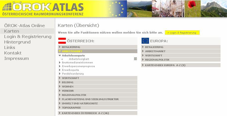
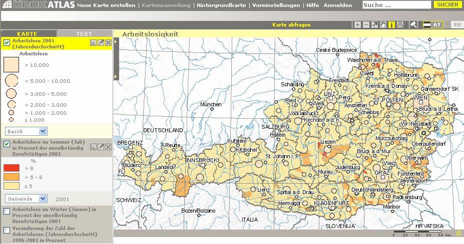

12


13 Geoland
14 Web-GIS - Advantages central stored information easy to use thematic information located on homogenous basemaps with aerials and satellite images easy to orientate no installation pubic-domain e-government-strategy
15 Web-GIS - limits in school All computers have online-access. broadband access to internet A video-projector in each classroom. Users are dependent on the availibility. limited number of functions

16 Jens Joachim Education Highway Sachsen, Germany


17 Swiss Federal Statistic Office


18 Tyrol -Atlas

19 Web-GIS integrated in textbooks Lothar Püschel (Rheinland-Pfalz, Germany)


20 Web-GIS German journals Lothar Püschel (Rheinland-Pfalz, Germany)


21 Web-GIS Austrian journal Alfons Koller published quaterly

22 Methodogical concepts 1 Gregor Falk, Yvonne Schleicher (Weingarten, Germany)
23 Methodogical concepts 2 Lothar Püschel (Rheinland-Pfalz, Germany) 1. Localisation and orientation 2. Analysing information 3. Interpretation and Evaluation 4.Production Identifying one s position, everyday localities, the position in a spatial context Reading maps, analysing with GIS-tools Reflecting the content, connecting it to one s own knowledge Developing one s own maps, using GIS-tools during projects

24 Meetings and conferences Working group Web-GIS at Lehrer-online, the German web-service for schools

25 Meetings and conferences AGIT GI_Forum Salzburg 4 th /5 th July 2007 Emphasis: Learning with Geoinformation in the German speaking branch


26 Dissemination-Events Annual GIS-Day Geo-Games
27 Thinking spatially a mainstream? Not at the moment! Data-services and functionalities have already been provided. Initiatives to incorporate into lessons are set. (textbooks, methodogical concepts)
28 Thinking spatially a mainstream?! the teachers turn school authorities: support and necessary equipment didactical research for monitoring Thinking spatially has the potential to become a mainstream in near future
29 Alfons Koller Thinking spatially a new mainstream in teaching geography?! Pedagogical University of the Diocese Linz kol@ph-linz.at L3Zentrum.ph-linz.at
30 Sarah Bednarz (2001, o.j.) IGU-CGE Conference in Stockholm on 6-10th August thinking with space is a powerful strategy in problem solving, learning, and communicating... thinking in / about / with space. Which tools are we able to use?
31 Google Earth and local data serviceproviders Austria doris.ooe.gv.at choose a name of a municipality or an address like post-code/street/number get aerial presented on Google Earth get links to data of local information service providers
GIS in Schools: Experiences and Progress in Germany
 Dirk Schaefer GIS in Schools: Experiences and Progress in Germany Since the 1990s geographic information systems (GIS) in Germany have become an important part of daily life; their significance in schools,
Techniques for Science Teachers: Using GIS in Science Classrooms.
 Techniques for Science Teachers: Using GIS in Science Classrooms. After ESRI, 2008 GIS A Geographic Information System A collection of computer hardware, software, and geographic data used together for
USING GIS TO SUPPORT PROCESS BASED GEOGRAPHY EDUCATION IN TURKEY: A CASE STUDY
 USING GIS TO SUPPORT PROCESS BASED GEOGRAPHY EDUCATION IN TURKEY: A CASE STUDY Eyüp Artvinli Eskişehir Osmangazi University Faculty of Education TURKEY ====================================== LEARNING WITH
Looking at Communities: Comparing Urban and Rural Neighborhoods
 Looking at Communities: Comparing Urban and Rural Neighborhoods OVERVIEW & OBJECTIVES Our urban areas have become so dominant that frequently the children we teach have no connection with and very few
GIS in German Schools Past Experiences and Future Outlooks
 GIS in German Schools Past Experiences and Future Outlooks Daniel Schober GIS macht Schule ESRI Geoinformatik GmbH Abstract The German educational system is organized by the federal states individually,
GED 554 IT & GIS. Lecture 6 Exercise 5. May 10, 2013
 GED 554 IT & GIS Lecture 6 Exercise 5 May 10, 2013 Free GIS data sources ******************* Mapping numerical data & Symbolization ******************* Exercise: Making maps for presentation GIS DATA SOFTWARE
An Introduction to Using Geographic Information Systems (GIS) in the Classroom
 in the Classroom") Georgia Southern University Digital Commons@Georgia Southern Interdisciplinary STEM Teaching & Learning Conference Mar 24th, 10:00 AM - 11:30 AM An Introduction to Using Geographic Information Systems
Georgia Southern University Digital Commons@Georgia Southern Interdisciplinary STEM Teaching & Learning Conference Mar 24th, 10:00 AM - 11:30 AM An Introduction to Using Geographic Information Systems
Esri and GIS Education
 Esri and GIS Education Organizations Esri Users 1,200 National Government Agencies 11,500 States & Regional Agencies 30,800 Cities & Local Governments 32,000 Businesses 8,500 Utilities 12,600 NGOs 11,000
My Map Activity MINNESOTA SOCIAL STUDIES STANDARDS & BENCHMARKS
 My Map Activity OVERVIEW & OBJECTIVES Students will learn the basics of Google Maps while using geospatial data to create their neighborhood map with the places they spend time. They will also collect
Conceptual Aspects of 3D Map Integration in Interactive School Atlases
 Conceptual Aspects of 3D Map Integration in Interactive School Atlases Christian Haeberling Hans Rudolf Baer Institute of Cartography ETH Zurich 8093 Zurich, Switzerland E-Mail: haeberling@karto.baug.ethz.ch
Map Collections and the Internet: Some Ideas about Various Online Map Services, Based on the ETH Map Collection in Zürich
 LIBER QUARTERLY, ISSN 1435-5205 LIBER 2000. All rights reserved K.G. Saur, Munich. Printed in Germany Map Collections and the Internet: Some Ideas about Various Online Map Services, Based on the ETH Map
The use of modern sources of information in shaping the geographic literacy of Russian school students
 Journal of Subject Didactics, 2017 Vol. 2, No. 2, 67-71, DOI: 10.5281/zenodo.1239720 Short Review The use of modern sources of information in shaping the geographic literacy of Russian school students
GIS Applications on Environmental Education in Taiwan
 GIS Applications on Environmental Education in Taiwan Track: Education Authors: Yu-Chen Lai, Mei-Ling Yeh, Tien-Yin Chou Abstract GIS is a perfect vehicle to deliver environmental knowledge and spatial
ST AMBROSE CATHOLIC PRIMARY SCHOOL Geography Policy
 ST AMBROSE CATHOLIC PRIMARY SCHOOL Geography Policy 2017-2018 Our school policy is developed in accordance with the National Curriculum for Geography and Foundation Stage Curriculum for Understanding of
CAWa Central Asian Water. Training Course Geographical Information Systems in Hydrology
 CAWa Central Asian Water Training Course Geographical Information Systems in Hydrology 1 Place & Time Place to hold the workshop: Helmholtz Centre Potsdam GFZ German Research Center for Geosciences, Germany
Better Topographic Map Production Using ArcGIS. A Comprehensive Solution for Mapping Organizations
 Better Topographic Map Production Using ArcGIS A Comprehensive Solution for Mapping Organizations The World Is Always Changing As a member of a national mapping organization, you know this is true. You
Advanced Algorithms for Geographic Information Systems CPSC 695
 Advanced Algorithms for Geographic Information Systems CPSC 695 Think about Geography What is Geography The 3 W s of Geography What is where Why is it there Why do I care Data - Data - Data We all got
The GIS Path Forward Saskatchewan s Geomatics Strategic Plan
 The GIS Path Forward Saskatchewan s Geomatics Strategic Plan John Potter, SK Ministry of Central Services Office of Geomatics Coordination Sept.17/13 Table of Contents 1. 2011-2016, Geomatics Strategic
AAG Partnerships for. Sustainable Development in Africa: Geospatial Science & Technology for. Partnerships and Applications
 AAG Partnerships for Sustainable Development in Africa Geospatial Science & Technology for Sustainable Development in Africa: Partnerships and Applications Harvard University John F. Kennedy School of
National Geographic World English 2 Workbook Answers
 We have made it easy for you to find a PDF Ebooks without any digging. And by having access to our ebooks online or by storing it on your computer, you have convenient answers with national geographic
Research of analog and digital data sources for landscape development analysis. Sebastian Kahlert, May 3 rd 2007 FIT 2005 UASE
 Research of analog and digital data sources for landscape development analysis Sebastian Kahlert, May 3 rd 2007 FIT 2005 UASE Agenda Objective of Research Project Material and Methodology Historic Maps
St. James C of E Primary School
 St. James C of E Primary School Geography Policy St. James C of E Primary School Geography Policy Written by: Lisa Harford Written: April 2016 Reviewed: April 2018 1. Introduction Geography is concerned
Your web browser (Safari 7) is out of date. For more security, comfort and. the best experience on this site: Update your browser Ignore
 is out of date. For more security, comfort and. the best experience on this site: Update your browser Ignore") Your web browser (Safari 7) is out of date. For more security, comfort and Activityengage the best experience on this site: Update your browser Ignore Introduction to GIS What is a geographic information
Your web browser (Safari 7) is out of date. For more security, comfort and Activityengage the best experience on this site: Update your browser Ignore Introduction to GIS What is a geographic information
An Alternate Career Choice for the Geography Major: Map, GIS, or Geographic Information Librarianship
 An Alternate Career Choice for the Geography Major: Map, GIS, or Geographic Information Librarianship Katherine H. Weimer Texas A&M University Libraries SWAAG 2007 - Bryan, Texas Overview of today s talk
The determinants of transport modal choice in Bodensee-Alpenrhein region
 The determinants of transport modal choice in Bodensee-Alpenrhein region Seyedeh Ashrafi University of Vienna Energie Innovation, February 2018 Modal choice is a decision process to choose between different
VIDEO: The World In A Box: Geographic Information Systems
 Geographic Information Systems VIDEO: The World In A Box: Geographic Information Systems Adapted from: The World In A Box: Geographic Information Systems. A Public Television Documentary, Opticus Corporation:
Bridging Geo technology Competence Gaps among Kenyan Undergraduate Students: An Interdisciplinary GIS Training Model at Chuka University
 International Journal of Education, Culture and Society 2016; 1(3): 70-74 http://www.sciencepublishinggroup.com/j/ijecs doi: 10.11648/j.ijecs.20160103.11 Bridging Geo technology Competence Gaps among Kenyan
DOWNLOAD OR READ : WORLD STUDIES GEOGRAPHY ASIA OCEANIA AFRICA GEOGRAPHY HISTORY CULTURETHE HISTORY OF ALEXANDER PDF EBOOK EPUB MOBI
 DOWNLOAD OR READ : WORLD STUDIES GEOGRAPHY ASIA OCEANIA AFRICA GEOGRAPHY HISTORY CULTURETHE HISTORY OF ALEXANDER PDF EBOOK EPUB MOBI Page 1 Page 2 alexander world studies geography asia pdf alexander Social
Minnesota K-12 Academic Standards in Social Studies. Grade 4: Geography of North America
 Minnesota K-12 Academic s in Social Studies Grade 4: Geography of North America 4 Describe how people take 1. Democratic government action to influence a depends on informed and decision on a specific
St Joseph s R.C. Primary School. Policy for Geography
 St Joseph s R.C. Primary School Policy for Geography 2016-2017 This policy is written with consideration to our school commitment to the Rights of the Child and our achievement of becoming a Rights Respecting
25. A Strategy for Integrating GIS
 25. A Strategy for Integrating GIS Richard P. Greene Introduction The teaching modules enabled middle and high school teachers in the Rockford public schools to explore the local community with geographic
CENSUS MAPPING WITH GIS IN NAMIBIA. BY Mrs. Ottilie Mwazi Central Bureau of Statistics Tel: October 2007
 CENSUS MAPPING WITH GIS IN NAMIBIA BY Mrs. Ottilie Mwazi Central Bureau of Statistics E-mail: omwazi@npc.gov.na Tel: + 264 61 283 4060 October 2007 Content of Presentation HISTORICAL BACKGROUND OF CENSUS
Spotlight on Population Resources for Geography Teachers. Pat Beeson, Education Services, Australian Bureau of Statistics
 Spotlight on Population Resources for Geography Teachers Pat Beeson, Education Services, Australian Bureau of Statistics Population Population size Distribution Age Structure Ethnic composition Gender
Sample assessment task. Task details. Content description. Year level 7
 Sample assessment task Year level 7 Learning area Subject Title of task Task details Description of task Type of assessment Purpose of assessment Assessment strategy Evidence to be collected Suggested
Lecture 11. Data Standards and Quality & New Developments in GIS
 Lecture 11 Data Standards and Quality & New Developments in GIS Lecture 11: Outline I. Data Standards and Quality 1. Types of Spatial Data Standards 2. Data Accuracy II. New Developments/The Future of
Your web browser (Safari 7) is out of date. For more security, comfort and. the best experience on this site: Update your browser Ignore
 is out of date. For more security, comfort and. the best experience on this site: Update your browser Ignore") Your web browser (Safari 7) is out of date. For more security, comfort and Activitydevelop the best experience on this site: Update your browser Ignore Introduction to Population Density How can you figure
Your web browser (Safari 7) is out of date. For more security, comfort and Activitydevelop the best experience on this site: Update your browser Ignore Introduction to Population Density How can you figure
Touring Around the Islands of Atlantic Canada
 Lesson Overview Touring Around the Islands of Atlantic Canada In this lesson, students will examine the history and heritage of the islands of Atlantic Canada and examine their similarities and differences.
Combining Geospatial and Statistical Data for Analysis & Dissemination
 Combining Geospatial and Statistical Data for Analysis & Dissemination (with Special Reference to Qatar Census 2010) Presentation by Mansoor Al Malki, Director of IT Department Qatar Statistics Authority
NR402 GIS Applications in Natural Resources
 NR402 GIS Applications in Natural Resources Lesson 1 Introduction to GIS Eva Strand, University of Idaho Map of the Pacific Northwest from http://www.or.blm.gov/gis/ Welcome to NR402 GIS Applications in
Digital Map of Mexico Platform and MxSIG. March 2017
 Digital Map of Mexico Platform and MxSIG March 2017 1 I. Digital Map of Mexico Platform Concept Evolution II. Digital Map of Mexico online Concept Capabilities Information available Other state units information
THE GIS LEARNING ENVIRONMENTS AT THE INSITUTE OF TERRESTRIAL ECOSYSTEMS OF THE ETH ZÜRICH
 Austro2007/FORMEC 07: Meeting the Needs of Tomorrows Forests New Developments in Forest Engineering, October 7 11, 2007, Vienna and Heiligenkreuz Austria THE GIS LEARNING ENVIRONMENTS AT THE INSITUTE OF
National Geographic Geography Bee Study Guide
 We have made it easy for you to find a PDF Ebooks without any digging. And by having access to our ebooks online or by storing it on your computer, you have convenient answers with national geographic
PaikkaOppi - a Virtual Learning Environment on Geographic Information for Upper Secondary School
 PaikkaOppi - a Virtual Learning Environment on Geographic Information for Upper Secondary School Jaakko Kähkönen*, Lassi Lehto*, Juha Riihelä** * Finnish Geodetic Institute, PO Box 15, FI-02431 Masala,
Rural GIS Applications Geospatial Technology Awareness
 Rural GIS Applications Geospatial Technology Awareness Mike Rudibaugh, Ph.D. Co-PI NSF GeoTech Center Geography/GIS Instructor Lake Land College mrudibau@lakeland.cc.il.us 217-234-5244 What is the GeoTech
Spatial Information Management in the Context of Organizational Development the Approach in North-Rhine Westphalia, Germany
 Spatial Information Management in the Context of Organizational Development the Approach in North-Rhine Westphalia, Germany Dr. Jens Riecken DVW Vice President c/o Ministry of the Interior North-Rhine
Geography. Programme of study for key stage 3 and attainment target (This is an extract from The National Curriculum 2007)
") Geography Programme of study for key stage 3 and attainment target (This is an extract from The National Curriculum 2007) Crown copyright 2007 Qualifications and Curriculum Authority 2007 Curriculum aims
Geography Programme of study for key stage 3 and attainment target (This is an extract from The National Curriculum 2007) Crown copyright 2007 Qualifications and Curriculum Authority 2007 Curriculum aims
Lecture 12. Data Standards and Quality & New Developments in GIS
 Lecture 12 Data Standards and Quality & New Developments in GIS Lecture 12: Outline I. Data Standards and Quality 1. Types of Spatial Data Standards 2. Data Accuracy 3. III. Documenting Spatial Data Accuracy
Creating Basemaps to Manage Buildings and Facilities
 Esri International User Conference San Diego, California Technical Workshops July 26, 2012 Creating Basemaps to Manage Buildings and Facilities Mark Stewart and Tamara Yoder Topics for this Session Overview
Session Objectives. Learn how to: Bring georeferenced aerial imagery into Civil 3D. Connect to and import GIS data using various tools and techniques.
 GIS into Civil 3D Data 70th Annual Wisconsin Society of Land Surveyors' Institute January 24, 2019 1 Learn how to: Session Objectives Bring georeferenced aerial imagery into Civil 3D. Connect to and import
Enrichment Materials
 Enrichment Materials Resources for deeper inquiry and advanced students The following third-party resources are recommended as enrichment materials for gifted or advanced students. World Geography Videos
2015 Copyright Board of Studies, Teaching and Educational Standards NSW for and on behalf of the Crown in right of the State of New South Wales.
 2015 Copyright Board of Studies, Teaching and Educational Standards NSW for and on behalf of the Crown in right of the State of New South Wales. This document contains Material prepared by the Board of
ArcGIS Online Tools and Water-Related Web Services You Can Use Every Day of Your Life!
 ArcGIS Online Tools and Water-Related Web Services You Can Use Every Day of Your Life! Brian Rowley, PE, CFM FMA 2014 Annual Conference 1 Gold Rush (49ers) John Sutter Sutter s Mill South fork of American
GIS Boot Camp for Education June th, 2011 Day 1. Instructor: Sabah Jabbouri Phone: (253) x 4854 Office: TC 136
 x 4854 Office: TC 136") GIS Boot Camp for Education June 27-30 th, 2011 Day 1 Instructor: Sabah Jabbouri Phone: (253) 833-9111 x 4854 Office: TC 136 Email: sjabbouri@greenriver.edu http://www.instruction.greenriver.edu/gis/ Summer
GIS Boot Camp for Education June 27-30 th, 2011 Day 1 Instructor: Sabah Jabbouri Phone: (253) 833-9111 x 4854 Office: TC 136 Email: sjabbouri@greenriver.edu http://www.instruction.greenriver.edu/gis/ Summer
3/4/2010. ESRI Education Community. CommunityWeb Mapping Tools
 Sketch-A-Map Reading, Writing and Math from a Different Perspective Education Community at ESRI Web Mapping Tools ESRI Education Community http://edcommunity.esri.com CommunityWeb Mapping Tools http://edcommunity.esri.com/maps/index.cfm
GIST 4302/5302: Spatial Analysis and Modeling Lecture 1: Overview
 GIST 4302/5302: Spatial Analysis and Modeling Lecture 1: Overview Guofeng Cao www.myweb.ttu.edu/gucao Department of Geosciences Texas Tech University guofeng.cao@ttu.edu Fall 2017 Texas Tech GIS Graduate
Grade 4 Benchmarks. Benchmark Concepts Skills Essential Question(s)
") **Be aware of the use of and & or in the benchmark language related to Canada and Mexico; sometimes students may look at the US and one of our neighboring countries and other times students need to study
**Be aware of the use of and & or in the benchmark language related to Canada and Mexico; sometimes students may look at the US and one of our neighboring countries and other times students need to study
Local Spatial Data Infrastructure, a Solid Base for Sustainable Land Management in Germany
 Local Spatial Data Infrastructure, a Solid Base for Sustainable Land Management in Germany FIG Commission 3 Workshop and Commission 3 Annual Meeting The Empowerment of Local Authorities: Spatial Information
Grant Agreement No. EIE/07/595/SI BEn
 Biomass energy register for sustainable site development for European regions Grant Agreement No. EIE/07/595/SI2.499697 BEn Biomass energy register for sustainable site development for European regions
Republic of Korea in Czech atlases and geography textbooks. Jan Ptacek, Kartografie Praha
 Republic of Korea in Czech atlases and geography textbooks Jan Ptacek, Kartografie Praha Schools in the Czech republic Primary schools 9 years (age 6 15) Geography from the age of 11, only one year of
Incorporating ArcGIS Pro in your Curriculum
 AAG, Boston 2017 April 5, 2017 Incorporating ArcGIS Pro in your Curriculum Geri Miller Agenda Concerns Acknowledged Learning curve ArcGIS Pro does not have all the tools (perception) Licensing and offline
COURSE INTRODUCTION & COURSE OVERVIEW
 week 1 COURSE INTRODUCTION & COURSE OVERVIEW topics of the week Instructor introduction Students introductions Course logistics Course objectives Definition of GIS The story of GIS introductions Who am
Austrian Wind Atlas and Wind Potential Analysis
 Austrian Wind Atlas and Wind Potential Analysis A. Krenn 1, H. Winkelmeier 1, R. Cattin 2, S. Müller 2, Truhetz 3, M. Biberacher 4, T. Eder 4 1. Energiewerkstatt, Friedburg, Austria 2. Meteotest, Bern,
netw rks Guided Reading Activity Essential Question: How does geography influence the way people live? What Is Geography?
 Guided Reading Activity What Is Geography? Lesson 1 Thinking Like a Geographer Essential Question: How does geography influence the way people live? Directions: Read the lesson and use your textbook to
Special Issue: Geospatial Technologies in Teacher Education
 Langran, E., & Baker, T. R. (2016). Geospatial technologies in teacher education: A brief overview. Contemporary Issues in Technology & Teacher Education, 16(3), 373-379. Special Issue: Geospatial Technologies
Topic: Fundamentals of Topographic Map (Cartographic Technique) Honors
 Honors") SN Kansagra School Master lesson Plan : Geography Subject Teacher :- Sanjay Nath Topic: Fundamentals of Topographic Map (Cartographic Technique) Honors Materials (Teaching Aids): White board, Audio visual
SN Kansagra School Master lesson Plan : Geography Subject Teacher :- Sanjay Nath Topic: Fundamentals of Topographic Map (Cartographic Technique) Honors Materials (Teaching Aids): White board, Audio visual
ArcGIS Earth for Enterprises DARRON PUSTAM ARCGIS EARTH CHRIS ANDREWS 3D
 ArcGIS Earth for Enterprises DARRON PUSTAM ARCGIS EARTH CHRIS ANDREWS 3D ArcGIS Earth is ArcGIS Earth is a lightweight globe desktop application that helps you explore any part of the world and investigate
European geography and what it can do for the future: the case of a bi-communal project in divided Cyprus
 European geography and what it can do for the future: the case of a bi-communal project in divided Cyprus Stavroula Philippou Assistant Professor (Curriculum & Instruction) Department of Education Sciences
Geo Business Gis In The Digital Organization
 We have made it easy for you to find a PDF Ebooks without any digging. And by having access to our ebooks online or by storing it on your computer, you have convenient answers with geo business gis in
Map Services Are We Getting It?
 Map Services Are We Getting It? Rich Herrmann VP Global Platforms & Technology, IHS James Sanders Senior Product Manager, IHS April 19, 2011 Houston, TX USA Overview The Challenge Keith Fraley s 2010 PUG
STAG LANE JUNIOR SCHOOL GEOGRAPHY POLICY
 Status-Recommended Prepared by: Megha Visavadia Date written January 2017 Shared with staff: Spring 2017 STAG LANE JUNIOR SCHOOL GEOGRAPHY POLICY Shared with governors: Spring 2018 Date for review: July
ESRI Delivering geographic information systems to millions of users
 Using Web GIS to Track Government Spending and Performance Eric Floss - ESRI April 12, 2010 ESRI Delivering geographic information systems to millions of users GIS Is Changing Everything How We Reason
Change in Globeville
 Change in Globeville Presented by: Benjamin Zank & Sylvia Brady, University of Denver - Department of Geography Project by: Nashwa Bolling, Sylvia Brady, Graham Emde, Michael King, Joseph Posten, Allison
TMBSS Geography Key Stage 3 Curriculum. Topics studied at Key Stage 3. TMBSS Geography Department Our Geography Curriculum Key Stage 3
 TMBSS Geography Department Our Geography Curriculum Key Stage 3 TMBSS Geography Department Key Stage 3 Curriculum for Geography Purpose of study: A high-quality geography education should inspire in pupils
Course Outline. School Name: Keewaytinook Internet High School. Department Name: Canadian and World Studies. Ministry of Education Course Title:
 School Name: Keewaytinook Internet High School Department Name: Canadian and World Studies Course Outline Ministry of Education Course Title: Travel and Tourism: A Geographic Perspective Grade Level: 11
GIS Education in Finnish Upper Secondary Schools
 GIS Education in Finnish Upper Secondary Schools Simo Tolvanen, MA Geography and Biology lecturer Kauhajoki Upper Secondary School Finland simo.tolvanen@kauhajoki.fi Photo: Simo Tolvanen Finland in Brief
Who are we? Use of German State s Rhineland-Palatinate Spatial Data Infrastructure for e-government INSPIRE. Topics of Presentation INSPIRE
 Who are we? University of Applied Sciences, Mainz, Germany Institute for Spatial Information and Surveying Technology Use of German State s Rhineland-Palatinate Spatial Data Infrastructure for e-government
ESRI educational site license in Bahir Dar University. Tegegn Molla Abebe Mengaw Geospatial Data and Technology Center, BDU
 ESRI educational site license in Bahir Dar University Tegegn Molla Abebe Mengaw Geospatial Data and Technology Center, BDU September, 2016 Mission, Vision Purpose and Values of the GDTC Mission of GDTC
Saskatchewan s Early Trade Routes: The Impact of Geography on Trade
 Saskatchewan s Early Trade Routes: The Impact of Geography on Trade Lesson Overview In this lesson, students will compare and contrast prehistoric First Nations trade routes and trade goods with the routes
Lessons Learned from the production of Gridded Population of the World Version 4 (GPW4) Columbia University, CIESIN, USA EFGS October 2014
 Columbia University, CIESIN, USA EFGS October 2014") Lessons Learned from the production of Gridded Population of the World Version 4 (GPW4) Columbia University, CIESIN, USA EFGS October 2014 Gridded Population of the World Gridded (raster) data product
Lessons Learned from the production of Gridded Population of the World Version 4 (GPW4) Columbia University, CIESIN, USA EFGS October 2014 Gridded Population of the World Gridded (raster) data product
An interactive tool for teaching map projections
 An interactive tool for teaching map projections Map projections are one of the fundamental concepts of geographic information science and cartography. An understanding of the different variants and properties
Enhancing Spatial Thinking in High-School Education: An Evaluation of Geography Textbooks in Taiwan
 Enhancing Thinking in High-School Education: An Evaluation of Geography Textbooks in Taiwan Jinn-Guey Lay 1, Chih-Ying Wu 2, Chia-Jung Wu 3, Chung-An Wang 4 1 National Taiwan University, No. 1, Sec. 4,
Lesson Plan 3 Land Cover Changes Over Time. An Introduction to Land Cover Changes over Time
 An Introduction to Land Cover Changes over Time This lesson plan builds on the lesson plan on Understanding Land Use and Land Cover Using Google Earth. Please refer to it in terms of definitions on land
The Purpose of the Charter on Geographical Education
 2016 International Charter on Geographical Education Contents Purpose of the Charter on Geographical Education... 1 The Contribution of Geography to Education 3 Research in Geographical Education... 3
2016 International Charter on. Geographical Education
 2016 International Charter on Geographical Education IGU UGI Commission on CGE Geographical Education Contents 1 The Proclamation 4 Affirmations 4 The Contribution of Geography to Education 5 Research
Geospatial Services in Special Libraries: A Needs Assessment Perspective
 Purdue University Purdue e-pubs Libraries Faculty and Staff Scholarship and Research Purdue Libraries 5-17-2013 Geospatial Services in Special Libraries: A Needs Assessment Perspective Ilana R. Barnes
USING GIS TO UPDATE A FIELD SERVICES PRICING MODEL & LEVERAGING GIS TO SUPPORT FIELD DATA COLLECTION AND PUBLIC EDUCATION.
 USING GIS TO UPDATE A FIELD SERVICES PRICING MODEL & LEVERAGING GIS TO SUPPORT FIELD DATA COLLECTION AND PUBLIC EDUCATION John May, GISP THE CHALLENGE Since 1992 TxDOT has had to comply with NPDES requirements
HIGH RESOLUTION BASE MAP: A CASE STUDY OF JNTUH-HYDERABAD CAMPUS
 HIGH RESOLUTION BASE MAP: A CASE STUDY OF JNTUH-HYDERABAD CAMPUS K.Manjula Vani, Abhinay Reddy, J. Venkatesh, Ballu Harish and R.S. Dwivedi ABSTRACT The proposed work High Resolution Base map: A Case study
ArcGIS Earth an Intro
 ArcGIS Earth an Intro Chris Andrews Product Manager, 3D and ArcGIS Earth Brian Sims 3D Content Lead 3D across the Esri product family ArcGIS Pro 3D Analyst CityEngine ArcGIS for Server ArcGIS Online ArcGIS
K- 5 Academic Standards in. Social Studies. June 2013
 K- 5 Academic s in Social Studies June 2013 Word Tables of s ONLY This Word version of the 2.17.12 social studies standards (DRAFT for Rulemaking 2.17.12) document contains the standards ONLY; no explanatory
Funding systems used in Mexico to support institutional arrangements: INEGI case
 Funding systems used in Mexico to support institutional arrangements: INEGI case Sistemas de financiamiento usados en México, para soportar arreglos institucionales: Caso INEGI United Nations Committee
St John s Catholic Primary School. Geography Policy. Mission Statement
 St John s Catholic Primary School Geography Policy Mission Statement We at St John s strive for excellence in education by providing a safe, secure and caring family environment where individuals are valued
Overview of CityGML. Dave Capstick, Ordnance Survey Research Department
 Overview of CityGML Dave Capstick, Ordnance Survey Research Department Introduction Why is citygml necessary CityGML development who is responsible? Ordnance Surveys interest 3D modelling basic concepts
Urban Planning Internet Geographic Information Systems Fall 2010
 Urban Planning - 794 Internet Geographic Information Systems Fall 2010 Instructor: Professor Huxhold (hux@uwm.edu) Lecturer: Melissa Mann (mmann@uwm.edu) Manager: Kurt Meingast (kurtm@uwm.edu) Schedule:
Cartographic and Geospatial Futures
 Cartographic and Geospatial Futures 1. Web Cartography, WebGIS, & Virtual Globes--New Roles for Maps, GIS, and GIS professionals 2. Map Mashups, the Neo Neo-geography Movement, & Crowd-sourcing Geospatial
Discovering Math Concepts in Advanced Algebra Teacher s Guide
 Discovering Math Concepts in Advanced Algebra Teacher s Guide Grade Level: 10 12 Curriculum Focus: Mathematics Lesson Duration: Three class periods Program Description Concepts in Advanced Algebra Calculate
Walworth Primary School
 Walworth Primary School Date: April 2016 Revision Due: April 2017 Ref: L.Smith Geography Policy 1 Geography Policy Introduction A high quality geography education should inspire in pupils a curiosity and
Planets Clues. Webaddress for this activity is:
 Planets Clues Webaddress for this activity is: COLLABORATIVE LEARNING PROJECT Project Director: Stuart Scott We support a network of teaching professionals throughout the European Union to promote inclusive
Introduction to Coastal GIS
 Introduction to Coastal GIS Event was held on Tues, 1/8/13 - Thurs, 1/10/13 Time: 9:00 am to 5:00 pm Location: Roger Williams University, Bristol, RI Audience: The intended audiences for this course are
Brazil Paper for the. Second Preparatory Meeting of the Proposed United Nations Committee of Experts on Global Geographic Information Management
 Brazil Paper for the Second Preparatory Meeting of the Proposed United Nations Committee of Experts on Global Geographic Information Management on Data Integration Introduction The quick development of
Lesson Plan 2 - Middle and High School Land Use and Land Cover Introduction. Understanding Land Use and Land Cover using Google Earth
 Understanding Land Use and Land Cover using Google Earth Image an image is a representation of reality. It can be a sketch, a painting, a photograph, or some other graphic representation such as satellite