The International Society for Photogrammetry and Remote Sensing Study on the Status of Mapping on the World
|
|
|
- Logan Augustine Mills
- 6 years ago
- Views:
Transcription
1 Joint ISPRS Project with the United Nations Committee of Experts on Geospatial Information Management UN GGIM Secretariat, New York The International Society for Photogrammetry and Remote Sensing Study on the Status of Mapping on the World Paper and presentation prepared by Gottfried Konecny, Emeritus Prof., Leibniz University Hannover, Germany
2 1. History of ISPRS UNGGIM Project Studies by the UN Secretariat in 1968, 1974, 1980, 1987 on the Status of Mapping in the World 1.2. Report on the Studies by A. Brandenberger, Laval University, Quebec, Canada at UNRCC AP 1987 in Bangkok, published in World Cartography XX, 1990 (status of data 1986) 1.3. Resolutions at UNRRCC AP and recently at UNRRCC AM 2009 with mandate to the Secretariat for a new study 1.4. Decision of ISPRS Council in November 2011 to offer cooperation to UNGGIM, approved by Dr. Cheung in Dec 2011
3 2. Status of Topographic Mapping , , ,9 96,2 87,5 90, : green, 1: yellow 1: violet, 1: red 77,7 99,2 84, ,1 21,7 15,2 66,4 18,3 24,3 54,4 45,1 37, ,9 0 Africa Asia Australia and Oceania Europe Former USSR 1: /3; 1: /2; 1: nearly complete North America South America
4 South America North America Europe Australia and Oceania Asia Africa World ,1 0,4 0,5 0,8 0,8 0,7 1,2 2 1,8 2,5 2,1 3,1 2,2 2,2 3,3 4 4, Map Updating ,8 5 6,4 6,3 7 7,5 8,3 World av. age of maps: 1: years years
5 3. Intermediate Results of the Study after the mailing of the questionnaire on April 27, 2012 by the GGIM Secretariat to UN Member Countries, 90 anwers were received by January 17, an analysis was made, after the design of a MS Access data base for the 27 questions 3.3. this analysis is presented to the UNGGIM Forum in Qatar, Feb 4 to 6, the analysis needs to be verified, this process will be assisted by the ISPRS Working Group IV 2. A meeting has been held April in Novosibirsk 3.5. a final UNGGIM publication and presentation is planned after the Meeting of Experts in Cambridge in July 2013
6 Returned Questionnaires from 90 Countries plus Northern Ireland out of 193 UN Member Countries Europe complete Americas o.k. Africa mixed Asia difficult this is considered a success, even though 100% completion for answers for coverage and age of maps is globally required
7 ISPRS Members not having answered in red ISPRS member country approach to complete the coverage of answers during the ISPRS Congress in Melbourne in August 2012 also did not help in most cases


8 International Map or Geodata Vendors can help to fill in the Missing answers for questions 1 and 2 East View Geospatial Minneapolis, MN, USA Internationales Landkartenhaus Stuttgart, Germany Example: Example: Supply of North Korean Maps Catalogue with map coverages of Guam
9 Question 1: Map Coverage from Questionnaire in green civilian maps from vendors in yellow military maps from vendors in blue But map vendors can supply a world coverage
10 Scales of Nationally Produced Maps from Vendors dark green 1:10 000, light green 1:25 000, yellow 1:50 000, brown 1: , red 1:
11 Scales of US produced Military Maps from Vendors green 1:10 000, yellow 1:50 000, brown 1: , red 1:
12 Scales of Russian Produced Military Maps from Vendors green 1:25 000, yellow 1:50 000, brown 1: , red 1:
13 Question 2: Map age combined from Questionnaires and fromvendors dark green <10 yrs, light green < 20yrs, orange < 30yrs, red > 30yrs, grey age not given
14 Question 4 : Web distribution of maps green = yes ; red = no
15 Question 4: Map Availability blue = free of charge ; green = for sale
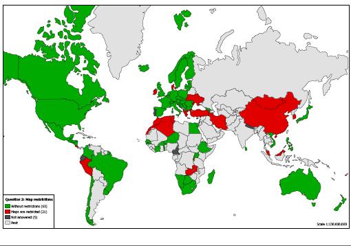
16 Map restrictions

17 Question 7 : Inhouse or Outsourcing green = inhouse, blue = outsourcing, brown = both
18 Question 9 : Use of Satellite Imagery for Mapping green = yes, red = no
19 Question 10 : Use of Lidar or Radar green = yes ; red = no
20 Question 12 : Orthophotos used in national mapping green = yes; red = no
21 Question 13 : Existence of National Digital Elevation Model
22 Question 14: NMA Interest in 3D Products green = yes; red = no
23 Question 16 : National Coverage of Cadastral Maps green = yes ; red = no
24 Question 16 : NMA responsibility for Cadastral Mapping green = yes ; red = no
25
26 Question 22 : Government Funding of Mapping green = yes ; red = no
27 Question 27 : Use of Servers for Archival of National Data Sets green = yes, red = no
28 4. Discussion: 4.1. how to still increase the number of returned questionnaires? Options: ISPRS WG IV 2, regional approaches, discussions with map vendors 4.2. how to address the efforts of industry? Options: activity by GGIM or by ISPRS
 Satellite Image")


29 4.2. Industrial Efforts (all data courtesy of Scanex, Russian Federation) Satellite Image Providers GeoEye1 GSD 50cm coverage 2011 Satellite Imagery for the by Scanex for Russian Federation Rosreestr 17M km2 61% coverage by GeoEye1 & World View 2 by Scanex 2012 Ikonos 0.8m GSD coverage for Scanex and Yandex in 2011

30 Google Earth, Google Maps, Google Streetmap, Google Ground Truth


31 4.2. Industrial Efforts Microsoft Bingmaps GSD 30cm Ultracam Imagery 2012 Microsoft Bingmaps GSD 15cm Google Earth and Google Maps aerial imagery locally bought or from satellite imagery providers
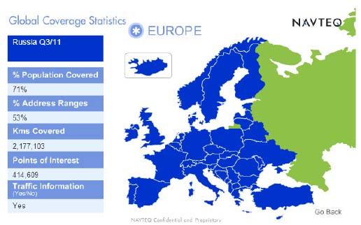
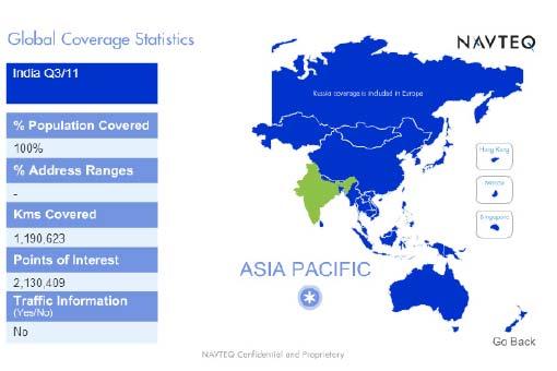
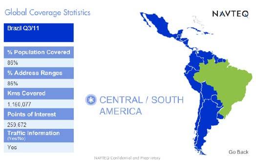
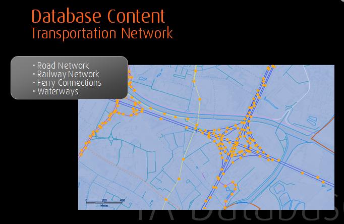
32 Navteq


33 Tele Atlas

34 TomTom Road Navigation Coverage

35 Crowd Sourcing in emergency situations
36 Conclusion: 1.UN GGIM needs to have the requested information 2.The member countries can help to provide and improve it 3.ISPRS will try its best to obtain it in sustainable cooperation with the help of the member countries and the UN GGIM Secretariat 4. it can invite industry to supplement missing governmental information 5. it hopes to make the information status sustainable despite of legal, political and human obstacles
37 the next opportunity to do this? 1.Through the Knowledge Base of the UNGGIM Website, where questionnaire forms in English, Spanish and French are still available, and which would be an asset to the effort by the UN Member States 2. ISPRS WG Meeting at Scanex Conference in Moscow, October 1 3, 2013 concentrating on imagery 3. The ISPRS Commission IV Symposium 2014 in Suzhou, May 14 16, 2014
The International Society for Photogrammetry and Remote Sensing Study on the Status of Mapping on the World
 Joint ISPRS Project with the United Nations Committee of Experts on Geospatial Information Management UN-GGIM Secretariat, New York The International Society for Photogrammetry and Remote Sensing Study
THE STATUS OF TOPOGRAPHIC MAPPING IN THE WORLD A UNGGIM - ISPRS PROJECT
 THE STATUS OF TOPOGRAPHIC MAPPING IN THE WORLD A UNGGIM - ISPRS PROJECT 2012-2015 G. Konecny, U. Breitkopf, A. Radtke Institute of Photogrammetry and GeoInformation, Leibniz Universität Hannover, Germany
THE CURRENT STATUS OF MAPPING IN THE WORLD - SPOTLIGHT ON PACIFIC ISLANDS
 THE CURRENT STATUS OF MAPPING IN THE WORLD - SPOTLIGHT ON PACIFIC ISLANDS John C. Trinder School of Civil and Environmental Engineering, UNSW SYDNEY NSW 2052, Australia (j.trinder@unsw.edu.au) Commission
Proceedings. GLOBAL GEOSPATIAL INFORMATION 25 April 2013 Novosibirsk, Russian Federation. Official support: Official sponsor: General sponsor:
 THE IX INTERNATIONAL EXHIBITION AND SCIENTIFIC CONGRESS INTEREXPO GEO-SIBERIA - 2013 25 April 2013, Novosibirsk, Russian Federation INTERNATIONAL SOCIETY FOR PHOTOGRAMMETRY AND REMOTE SENSING (ISPRS) SIBERIAN
Economic and Social Council 2 July 2015
 ADVANCE UNEDITED VERSION UNITED NATIONS E/C.20/2015/11/Add.1 Economic and Social Council 2 July 2015 Committee of Experts on Global Geospatial Information Management Fifth session New York, 5-7 August
QUESTIONNAIRE THE CURRENT STATUS OF MAPPING IN THE WORLD
 QUESTIONNAIRE ON THE CURRENT STATUS OF MAPPING IN THE WORLD The questionnaire is intended to take stock of the current status of mapping in the world. The information collected will eventually be used
Background Document: Report of the Regional Committee of United Nations Global Geospatial Information Management for Asia and the Pacific
 Background Document: Report of the Regional Committee of United Nations Global Geospatial Information Management for Asia and the Pacific 1. Summary 1. This report highlights the activities carried out
ECONOMIC AND SOCIAL COUNCIL
 UNITED NATIONS E/CONF.102/3 ECONOMIC AND SOCIAL COUNCIL Nineteenth United Nations Regional Cartographic Conference for Asia and the Pacific Bangkok, 29 October 1 November 2012 Item 4 of the provisional
Report of the Regional Committee of UN-GGIM for Asia and the Pacific (UN-GGIM-AP)
") Report of the Regional Committee of UN-GGIM for Asia and the Pacific (UN-GGIM-AP) At the Eighth Session of UN-GGIM UN Headquarters, New York, 1 3 August 2018 About UN-GGIM-AP One of the five regional committees
Report of the Regional Committee of UN-GGIM for Asia and the Pacific (UN-GGIM-AP) At the Eighth Session of UN-GGIM UN Headquarters, New York, 1 3 August 2018 About UN-GGIM-AP One of the five regional committees
Inventory of United Nations Resolutions on Cartography Coordination, Geographic Information and SDI 1
 Inventory of United Nations Resolutions on Cartography Coordination, Geographic Information and SDI I. Resolutions on Cartography Coordination and Establishment of United Nations Regional Cartographic
Economic and Social Council
 United Nations Economic and Social Council Distr.: General 18 July 2016 Original: English Committee of Experts on Global Geospatial Information Management Sixth session New York, 3-5 August 2016 Item 2
8 th Arctic Regional Hydrographic Commission Meeting September 2018, Longyearbyen, Svalbard Norway
 8 th Arctic Regional Hydrographic Commission Meeting 11-13 September 2018, Longyearbyen, Svalbard Norway Status Report of the Arctic Regional Marine Spatial Data Infrastructures Working Group (ARMSDIWG)
From PCGIAP to UN GGIM AP: A Regional Perspective on GGIM
 Regional Committee of United Nations Global Geospatial Information Management for Asia and the Pacific (UN-GGIM-AP) Established by a United Nations Resolution From PCGIAP to UN GGIM AP: A Regional Perspective
Bengt Kjellson Chair of the Executive Committee UN-GGIM: Europe. 2 nd Joint UN-GGIM: Europe ESS Meeting 11 th March 2016, Luxembourg
 Bengt Kjellson Chair of the Executive Committee UN-GGIM: Europe 2 nd Joint UN-GGIM: Europe ESS Meeting 11 th March 2016, Luxembourg A global geospatial mandate At its 47th plenary in July 2011, ECOSOC,
Chris Rizos (IAG), Chair William Cartwright (ICA), immediate past Chair
, Chair William Cartwright (ICA), immediate past Chair") Chris Rizos (IAG), Chair William Cartwright (ICA), immediate past Chair Global Spatial Data Infrastructure (GSDI) Association IEEE Geoscience & Remote Sensing Society (IEEE-GRSS) International Association
Chris Rizos (IAG), Chair William Cartwright (ICA), immediate past Chair Global Spatial Data Infrastructure (GSDI) Association IEEE Geoscience & Remote Sensing Society (IEEE-GRSS) International Association
Working Group 3 on Regional SDI. Activity Report. for. The 5th UN-GGIM-AP Plenary Meeting
 Regional Committee of United Nations Global Geospatial Information Management for Asia and the Pacific (UN-GGIM-AP) Working Group 3 on Regional SDI Activity Report for The 5th UN-GGIM-AP Plenary Meeting
Spanish national plan for land observation: new collaborative production system in Europe
 ADVANCE UNEDITED VERSION UNITED NATIONS E/CONF.103/5/Add.1 Economic and Social Affairs 9 July 2013 Tenth United Nations Regional Cartographic Conference for the Americas New York, 19-23, August 2013 Item
Report of the Working Group 2 Data Sharing and Integration for Disaster Management *
 UNITED NATIONS E/CONF.104/6 ECONOMIC AND SOCIAL COUNCIL Twentieth United Nations Regional Cartographic Conference for Asia and the Pacific Jeju, 6-9 October 2015 Item 5 of the provisional agenda Report
REGIONAL SDI DEVELOPMENT
 REGIONAL SDI DEVELOPMENT Abbas Rajabifard 1 and Ian P. Williamson 2 1 Deputy Director and Senior Research Fellow Email: abbas.r@unimelb.edu.au 2 Director, Professor of Surveying and Land Information, Email:
Working Group 1. Geodetic Reference Frame. Activity Report. for. The UN-GGIM-AP Plenary Meeting
 Regional Committee of United Nations Global Geospatial Information Management for Asia and the Pacific (UN-GGIM-AP) Established by a United Nations Resolution Working Group 1 Geodetic Reference Frame Activity
Manitoba s Elevation (LiDAR) & Imagery Datasets. Acquisition Plans & Opportunities for Collaboration
 & Imagery Datasets. Acquisition Plans & Opportunities for Collaboration") Manitoba s Elevation (LiDAR) & Imagery Datasets Acquisition Plans & Opportunities for Collaboration Manitoba Planning Conference May 2017 Presentation Outline Manitoba s Elevation (LiDAR) and Imagery Datasets
Manitoba s Elevation (LiDAR) & Imagery Datasets Acquisition Plans & Opportunities for Collaboration Manitoba Planning Conference May 2017 Presentation Outline Manitoba s Elevation (LiDAR) and Imagery Datasets
The Arctic SDI - A circumpolar initiative -
 Arctic The Arctic - A circumpolar initiative - ULI, Uppsala October 4, 2011 www. arctic-sdi.org Owe Palmér Martin Skedsmo Project Management Group Lantmäteriet Norwegian Mapping Authority October 2011
Data Origin. How to obtain geodata? Ron van Lammeren CGI-GIRS 0910
 Data Origin How to obtain geodata? Ron van Lammeren CGI-GIRS 0910 Spatial Data interest Improvement of policy making. ± 90% of all information used by government has spatial characteristics SPATIAL INFORMATION
Report on the Actions Taken on Resolutions of the Eighteenth United Nations Regional Cartographic Conference for Asia and the Pacific
 UNITED NATIONS E/CONF.102/7 ECONOMIC AND SOCIAL COUNCIL Nineteenth United Nations Regional Cartographic Conference for Asia and the Pacific Bangkok, 29 October 1 November 2012 Item 4 of the provisional
The Geospatial Information Management (GIM) INSPIRE Data Specification and COPERNICUS In situ data
 INSPIRE Data Specification and COPERNICUS In situ data") INSPIRE conference Barcelona 29 September 2016 INSPIRing a sustainable environment The Geospatial Information Management (GIM) INSPIRE Data Specification and COPERNICUS In situ data Antonio Arozarena,
INSPIRE conference Barcelona 29 September 2016 INSPIRing a sustainable environment The Geospatial Information Management (GIM) INSPIRE Data Specification and COPERNICUS In situ data Antonio Arozarena,
Arctic Spatial Data Infrastructure (SDI) - Pan-Arctic Cooperation among Ten Mapping Agencies (Skedsmo, Palmer, Taylor, Gudmundsson)
 - Pan-Arctic Cooperation among Ten Mapping Agencies (Skedsmo, Palmer, Taylor, Gudmundsson)") Arctic Arctic Spatial Data Infrastructure () - Pan-Arctic Cooperation among Ten Mapping Agencies (Skedsmo, Palmer, Taylor, Gudmundsson) G 13 2012, Quebec, Canada May 14, 2012 www. arctic-sdi.org Owe Bengt
Arctic Arctic Spatial Data Infrastructure () - Pan-Arctic Cooperation among Ten Mapping Agencies (Skedsmo, Palmer, Taylor, Gudmundsson) G 13 2012, Quebec, Canada May 14, 2012 www. arctic-sdi.org Owe Bengt
E/CONF.105/158/CRP.158
 E/CONF.105/158/CRP.158 14 July 2017 Original: English Eleventh United Nations Conference on the Standardization of Geographical Names New York, 8-17 August 2017 Item 8 of the provisional agenda* Measures
2018/1 The integration of statistical and geospatial information. The Regional Committee of UN-GGIM: Americas:
 The following are the conclusions and recommendations of the Regional Committee of the United Nations on Global Geospatial Information Management for the Americas, during its Fifth Session, Thursday 8
Data Origin. Ron van Lammeren CGI-GIRS 0910
 Data Origin Ron van Lammeren CGI-GIRS 0910 How to obtain geodata? Geo data initiative Executive Order 12906, "Coordinating Geographic Data Acquisition and Access: The National Spatial Data Infrastructure,"
UN GGIM and National SDI Strategy
 MSDI Open Forum on 26 th January 2016 Contributing to the successful delivery of MSDI UN GGIM and National SDI Strategy Hiroshi Murakami Deputy Administrator Geospatial Information Authority of Japan Geospatial
The Efforts of Building GIS Infrastructure in a Newly Independent State: The case of Timor Leste *
 UNITED NATIONS E/CONF.100/IP.12 ECONOMIC AND SOCIAL COUNCIL Eighteenth United Nations Regional Cartographic Conference for Asia and the Pacific Bangkok, 26-29 October 2009 Item 7(b) of the provisional
The future of SDIs. Ian Masser
 The future of SDIs Ian Masser Presentation Considers two questions relating to the future development of SDIs throughout the world Where have we got to now? Where should we go from here? Identifies four
Earth Observations as a Tool To Achieve Sustainable Development Goals
 The image part with relationship ID rid3 was not found in the file. 16/10/2017 Earth Observations as a Tool To Achieve Sustainable Development Goals LI Jing, China GEO On behalf of the Group on Earth Observations
Vanuatu Country Map By Hema By Hema Maps
 Vanuatu Country Map By Hema By Hema Maps If searched for a book by Hema Maps Vanuatu Country Map by Hema in pdf format, then you have come on to right website. We present the full release of this ebook
GEOMATICS. Shaping our world. A company of
 GEOMATICS Shaping our world A company of OUR EXPERTISE Geomatics Geomatics plays a mayor role in hydropower, land and water resources, urban development, transport & mobility, renewable energy, and infrastructure
EuroSDR (European Spatial Data Research)
") EuroSDR (European Spatial Data Research) ROLLING RESEARCH PLAN 2015-2018 EuroSDR Secretariat Public Governance Institute KU Leuven Parkstraat 45 bus 3609 3000 Leuven Belgium Tel.: +32 16 32 31 80 Fax:
EuroSDR (European Spatial Data Research) ROLLING RESEARCH PLAN 2015-2018 EuroSDR Secretariat Public Governance Institute KU Leuven Parkstraat 45 bus 3609 3000 Leuven Belgium Tel.: +32 16 32 31 80 Fax:
UN-GGIM: An Overview Stefan Schweinfest, Director (UNSD) Bangkok, 27 March 2015
 Bangkok, 27 March 2015") UN-GGIM: An Overview Stefan Schweinfest, Director (UNSD) Bangkok, 27 March 2015 ggim.un.org UN-GGIM: A global initiative Formal inter-governmental UN Committee of Experts to: Discuss, enhance and coordinate
UN-GGIM: An Overview Stefan Schweinfest, Director (UNSD) Bangkok, 27 March 2015 ggim.un.org UN-GGIM: A global initiative Formal inter-governmental UN Committee of Experts to: Discuss, enhance and coordinate
Challenges and Potentials of Place Based Information Management in Nepal"
 Nineteenth United Nations Regional Cartographic Conference for Asia and the Pacific, Bangkok, Thailand, 29 October 1 November 2012 Challenges and Potentials of Place Based Information Management in Nepal"
European Spatial Data Research. EuroSDR. Prof. Dr. Ir. Joep Crompvoets. General Assembly CLGE Tirana 18 March
 EuroSDR Prof. Dr. Ir. Joep Crompvoets General Assembly CLGE - 2016 Tirana 18 March 2016 INTRODUCTORY QUESTIONS Who knows what is EuroSDR? Who does NOT know what is EuroSDR? Who is employed at mapping agencies?
SDG s and the role of Earth Observation
 SDG s and the role of Earth Observation Christian Heipke IPI - Institute for Photogrammetry and GeoInformation Leibniz Universität Hannover Germany Secretary General, ISPRS 1. No Poverty 2. Zero Hunger
Fundamental Geospatial Data Themes
 Fundamental Geospatial Data Themes April 2016 Workshop Agenda Background why and how What is our objective? Fundamental data what are they? What are the candidate themes? Breakout Session Conclusion Background
IAEG SDGs WG GI, , Mexico City
 IAEG SDGs WG GI, 12-14.12.2016, Mexico City UN-GGIM:Europe s perspective and activities to support better integration of geospatial information and statistics and the UN SDG monitoring Pier-Giorgio Zaccheddu,
Fundamental Geospatial Data Themes. Panel Discussion
 Fundamental Geospatial Data Themes Panel Discussion April 2016 Background GGIM5 discussed fundamental geospatial data themes Agreed there is an urgent need for a set of global fundamental geospatial data
PAN AMERICAN INSTITUTE OF GEOGRAPHY AND HISTORY Specialized Organization of the OAS
 PAN AMERICAN INSTITUTE OF GEOGRAPHY AND HISTORY Specialized Organization of the OAS 10 th UNRCC Americas United Nations, New York, 20 August 2013 PAIGH, SIRGAS, PC-IDEA and GeoSUR 2013-2015 Joint Action
IAEG-SDGs WGGI Task Team Dec. 7, 2017, New York
 IAEG-SDGs WGGI Task Team Dec. 7, 2017, New York Contents What are G/A data? Role of G/A data Utilization Recommendations Outlook National Geospatial Data for SDGs Official data products generated by authoritative
Economic and Social Council
 United Nations Economic and Social Council Distr.: General 2 July 2012 E/C.20/2012/10/Add.1 Original: English Committee of Experts on Global Geospatial Information Management Second session New York, 13-15
United Nations Group Of Experts On Geographical Names
 Rudolph MATINDAS, Indonesia or William WATT, Australia Key words: place names, UNGEGN SUMMARY UNGEGN Discussing the strategic aims of UNGEGN and its divisional structure, future direction, and the benefits
Spatial Data Infrastructure Concepts and Components. Douglas Nebert U.S. Federal Geographic Data Committee Secretariat
 Spatial Data Infrastructure Concepts and Components Douglas Nebert U.S. Federal Geographic Data Committee Secretariat August 2009 What is a Spatial Data Infrastructure (SDI)? The SDI provides a basis for
Geospatial Policy Development and Institutional Arrangements *
 HIGH LEVEL FORUM ON GLOBAL GEOSPATIAL MANAGEMENT INFORMATION WORKING PAPER No. 13 First Forum Seoul, Republic of Korea, 24-26 October 2011 Geospatial Policy Development and Institutional Arrangements *
UN-GGIM: Europe GRF-Europe. Markku Poutanen
 UN-GGIM: Europe GRF-Europe Markku Poutanen Global Geodetic Reference Frame GGRF The UN Committee of Experts on Global Geospatial Information Management (UN-GGIM) decided in July 2013 to formulate and facilitate
Economic and Social Council
 United Nation E/C.20/2012/4/Add.1 Economic and Social Council Distr.: General 2 July 2012 Original: English Committee of Experts on Global Geospatial Information Management Second session New York, 13-15
World Status of National Spatial Data Clearinghouses
 World Status of National Spatial Data Clearinghouses Joep Crompvoets and Arnold Bregt Abstract: In December 2001, a survey of the World Wide Web was carried out to assess systematically the state-of-the-art
Second Administrative Level Boundaries (SALB) initiative & geographic names in cartography. Geospatial Information Section
 initiative & geographic names in cartography. Geospatial Information Section") Second Administrative Level Boundaries (SALB) initiative & geographic names in cartography Geospatial Information Section Introduction Goals Global agenda How does SALB work? Latest News on geographic
Second Administrative Level Boundaries (SALB) initiative & geographic names in cartography Geospatial Information Section Introduction Goals Global agenda How does SALB work? Latest News on geographic
Qatar s Nation-Wide GIS Cooperation on Local and Regional Levels
 Qatar s Nation-Wide GIS Cooperation on Local and Regional Levels Dr. Mohammad Abd El-Wahab Hamouda GIS Consultant & Chairman of GIS Coordinators Group The Center for GIS State of Qatar Second High Level
Report on the establishment of UN GGIM: Europe Item 14. 4th session of the Committee of Experts on UN-GGIM
 Report on the establishment of UN GGIM: Europe Item 14 1 Why regional European committees of UN GGIM? In the ECOSOC resolution 2011/24 on the UN GGIM: Emphasizes the importance of promoting national, regional
What is the PCGIAP? Overview on PCGIAP Activities and the Asia/Pacific Region. Membership. Background. Aims. Asia-Pacific SDI
 3rd FIG Regional Conference for Asia and the Pacific Jakarta, Indonesia, 3-7th October 2004 Overview on PCGIAP Activities and the Asia/Pacific Region What is the PCGIAP? Haji Matusin Matasan Surveyor General,
Use of the ISO Quality standards at the NMCAs Results from questionnaires taken in 2004 and 2011
 Use of the ISO 19100 Quality standards at the NMCAs Results from questionnaires taken in 2004 and 2011 Eurogeographics Quality Knowledge Exchange Network Reference: History Version Author Date Comments
Coordination of United Nations Activities related to Geospatial Information Management
 Coordination of United Nations Activities related to Geospatial Information Management UNGIWG UNITED NATIONS GEOGRAPHIC INFORMATION WORKING GROUP THE UNITED NATIONS COMMITTEE OF EXPERTS ON GLOBAL GEOSPATIAL
Activities relating to the Working Group on Toponymic Data Files and Gazetteers*
 UNITED NATIONS WORKING PAPER GROUP OF EXPERTS NO. 10 ON GEOGRAPHICAL NAMES Twenty-seventh session 30 July and 10 August 2012, New York Item 3 of the Provisional Agenda Reports of the working groups Activities
E/CONF.105/64/CRP.64. The International Map Year
 E/CONF.105/64/CRP.64 30 June 2017 Original: English Eleventh United Nations Conference on the Standardization of Geographical Names New York, 8-17 August 2017 Item 7 of the provisional agenda* National
Implementing the Sustainable Development Goals: The Role of Geospatial Technology and Innovation
 Fifth High Level Forum on UN Global Geospatial Information Management Implementing the Sustainable Development Goals: The Role of Geospatial Technology and Innovation 28-30 November 2017 Sheraton Maria
The UN discusses Global Geospatial Information Management
 The UN discusses Global Geospatial Information Management Just like statistics, every country must have authoritative, trusted, maintained, definitive mapping data Professor Paul Cheung, Director, United
Geographical Names Activities in Africa The Gaborone Action Plan
 United Nations Group of Experts on Geographical Names Geographical Names Activities in Africa The Gaborone Action Plan 6 th Meeting of the Committee of Director -Generals of National Statistics Offices
East View Geospatial Products and Services
 East View Geospatial Products and Services Sevastopol, Ukraine 1:100,000 vector data Map Sourcing East View Geospatial (EVG) delivers a comprehensive suite of map sourcing and services at various scales
Web 2.0, map production & publishing and geospatial information dissemenation
 Web 2.0, map production & publishing and geospatial information dissemenation Professor William Cartwright President, International Cartographic Association William Cartwright 18th UNRCC for Asia and the
1) United Nations Committee of Experts on Global Geospatial Information Management (UN-GGIM)
 United Nations Committee of Experts on Global Geospatial Information Management (UN-GGIM)") International Workshop on Legal and Policy Frameworks for Geospatial Information Management Licensing of Geospatial Information 7 9 November 2017 Tianjin Zhengxie Club Hotel Tianjin, China Outline of presentation
International Workshop on Legal and Policy Frameworks for Geospatial Information Management Licensing of Geospatial Information 7 9 November 2017 Tianjin Zhengxie Club Hotel Tianjin, China Outline of presentation
USING GIS CARTOGRAPHIC MODELING TO ANALYSIS SPATIAL DISTRIBUTION OF LANDSLIDE SENSITIVE AREAS IN YANGMINGSHAN NATIONAL PARK, TAIWAN
 CO-145 USING GIS CARTOGRAPHIC MODELING TO ANALYSIS SPATIAL DISTRIBUTION OF LANDSLIDE SENSITIVE AREAS IN YANGMINGSHAN NATIONAL PARK, TAIWAN DING Y.C. Chinese Culture University., TAIPEI, TAIWAN, PROVINCE
Challenges in Geospatial Policy Formulation and Programme Management
 Challenges in Geospatial Policy Formulation and Programme Management Luiz Paulo Souto Fortes, PhD An Exchange with the Geospatial Industry for UN-GGIM Seoul, October 23, 2011 BRAZIL Land area 8,514,876.599
GSDI Global Spatial Data Infrastructure. Convergences between Geo Spatial Communities: key decision for decision making
 GSDI Global Spatial Data Infrastructure Convergences between Geo Spatial Communities: key decision for decision making April 14 th 2010 Bas Kok GSDI Past-President Director of International Affairs, Dutch
Cooperation is the key, FIG can facilitate
 Cooperation is the key, FIG can facilitate Mikael Lilje Vice President 2017-2020 Head, Geodetic infrastructure, Swedish mapping, cadastral and land registration authority Presented at the GIS/RS Conference
Analysis of Regional Fundamental Datasets Questionnaire
 Permanent Committee on GIS Infrastructure for Asia and the Pacific Working Group 2 Regional Fundamental Data Summary Report on Analysis of Regional Fundamental Datasets Questionnaire ABBAS RAJABIFARD and
UN Resolution on GGRF ( and its implementation in Europe)
") Presented at the FIG Working Week 2017, UN Resolution on GGRF ( and its implementation in Europe) May 29 - June 2, 2017 in Helsinki, Finland Markku Poutanen, FGI Contents Global Geodetic Reference Frame
Presented at the FIG Working Week 2017, UN Resolution on GGRF ( and its implementation in Europe) May 29 - June 2, 2017 in Helsinki, Finland Markku Poutanen, FGI Contents Global Geodetic Reference Frame
GEOGRAPHIC INFORMATION SYSTEMS Session 8
 GEOGRAPHIC INFORMATION SYSTEMS Session 8 Introduction Geography underpins all activities associated with a census Census geography is essential to plan and manage fieldwork as well as to report results
State GIS Officer/GIS Data
 State GIS Officer/GIS Data This Act creates the position of state Geographic Information Systems (GIS) officer. The Act: requires the state GIS officer to adopt or veto the GIS data standards and a statewide
Global Geodetic Reference Frame GGRF & Implications for GNSS
 Global Geodetic Reference Frame GGRF & Implications for GNSS On behalf of Gary Johnston Chair GIAC, Ruth Neilan Vice Chair, Global Geodetic Observing System ICG-9 Prague, 10 November 2014 UN GGRF Working
Turkey National Report
 UNITED NATIONS Working Paper GROUP OF EXPERTS ON No. 26 GEOGRAPHICAL NAMES Twenty-third Session Vienna, 28 March 4 April 2006 Item 5 of the Provisional Agenda: Reports of the division Turkey National Report
Funding models for institutional arrangements in the context of a national SDI: the case of Chile
 Funding models for institutional arrangements in the context of a national SDI: the case of Chile Alvaro Monett Hernández Executive Secretary SNIT Chile Vice-President UN-GGIM Américas Fifth Meeting of
Global Mapping: A Tool for Disaster Mitigation
 Global Mapping: A Tool for Disaster Mitigation D. R. Fraser Taylor Chair, International Steering Committee for Global Mapping (ISCGM) fraser_taylor@carleton.ca www. United Nations Regional Cartographic
Committee of Experts on Background document 1. Critical issues relating to the integration of land and marine geospatial information
 Committee of Experts on Background document 1 Global Geospatial Information Management Available in English only Third session Cambridge, United Kingdom of Great Britain and Northern Ireland 24-26 July
African requirements for SDI standardization Antony Cooper Operating Unit Fellow Built Environment CSIR PO Box 395, Pretoria, 0001, South Africa
 ISO/TC 211 workshop on spatial data infrastructures (SDIs) African requirements for SDI standardization Antony Cooper Operating Unit Fellow Built Environment CSIR PO Box 395, Pretoria, 0001, South Africa
East View Cartographic
 New Developments in Access to Russian Military Mapping 1 + affiliate of East View Publications (est. 1989) + EVP is by far the largest supplier of vernacular-language open-source information from Russia/CIS
United Nations Environment Programme
 UNITED NATIONS United Nations Environment Programme Distr. GENERAL 13 April 2016 EP ORIGINAL: ENGLISH EXECUTIVE COMMITTEE OF THE MULTILATERAL FUND FOR THE IMPLEMENTATION OF THE MONTREAL PROTOCOL Seventy-sixth
Terrain Analysis Of Afghanistan By East View Cartographic READ ONLINE
 Terrain Analysis Of Afghanistan By East View Cartographic READ ONLINE If searching for the book Terrain Analysis of Afghanistan by East View Cartographic in pdf form, in that case you come on to the faithful
Economic and Social Council
 United Nations Economic and Social Council Distr.: General 30 August 2012 Original: English Economic Commission for Europe Inland Transport Committee Working Party on Rail Transport Sixty-sixth session
Development of Global Map for GEOSS SBAs US-09-03a
 Development of Global Map for GEOSS SBAs US-09-03a UIC User Engagement Session 2 November, 2010 Yoshikazu FUKUSHIMA Secretariat General of International Steering Committee for Global Mapping Geospatial
Sustainable Development Goals UN-GGIM Task Team
 Sustainable Development Goals UN-GGIM Task Team Executive Committee Meeting, 1. June 2016 Kristian Møller Copyright 2013 EuroGeographics Developments Creation of the One pager and matrix Reviewed by UN-GGIM:
Geospatial Information Management in the Americas: Lessons for the Post-2015 development agenda
 Geospatial Information Management in the Americas: Lessons for the Post-2015 development agenda Rolando Ocampo President, UN-GGIM: Americas October 2014 The integration of statistical and geographical
Geospatial Big Data. Greg Scott Inter-Regional Advisor Global Geospatial Information Management United Nations Statistics Division. ggim.un.
 Geospatial Big Data Greg Scott Inter-Regional Advisor Global Geospatial Information Management United Nations Statistics Division Positioning geospatial information to address global challenges ggim.un.org
SDI Development in Georgia. Mari Khardziani Head of International Relations Unit National Agency of Public Registry
 SDI Development in Georgia Mari Khardziani Head of International Relations Unit National Agency of Public Registry Kehl, Germany September 5, 2017 2 National Agency of Public Registry Legal Entity of Public
Progress of UN-GGIM: Europe Working Group A on Core Data
 PolicyKEN Budapest 29 November 2016 Progress of UN-GGIM: Europe Working Group A on Core Data François Chirié, Dominique Laurent, IGNF Core data context Background and purpose Aim of Work Group A to propose
GEOMATICS AND DISASTER MANAGEMENT: Early Impact assessment in Haiti
 GEOMATICS AND DISASTER MANAGEMENT: Early Impact assessment in Haiti We will talk about... Post-disaster response: the main questions to be answered Post-disaster rapid mapping: the role of Geomatics The
Upgrade the Datasets in NSDI for Smarter Services with the Cases of China
 Upgrade the Datasets in NSDI for Smarter Services with the Cases of China By Dr. JIANG Jie Dept of GeoInformaiton Service Platform National Geomatics Center of China October 7, 2015 Jeju, Republic of Korea
Spatially Enabled Society
 International Seminar on Land Administration Trends and Issues in Asia and the Pacific Region Spatially Enabled Society Abbas Rajabifard Vice Chair PCGIAP-WG3 Vice-President (President Elect), GSDI Association
A/AC.105/C.1/2012/CRP.10
 A/AC.105/C.1/2012/CRP.10 1 February 2012 English only Committee on the Peaceful Uses of Outer Space Scientific and Technical Subcommittee Forty-ninth session Vienna, 6-17 February 2012 Item 6 of the provisional
VERY HIGH RESOLUTION SATELLITE DATA FOR CADASTRAL MAPPING
 132 Romuald Kaczynski, Michal Kedzierski Military University of Technology, Warsaw, Poland VERY HIGH RESOLUTION SATELLITE DATA FOR CADASTRAL MAPPING Kaczynski Romuald, Kedzierski Michal, 2013 В статье
EUREF 2014 Resolutions. Z. Altamimi, C. Bruyninx, R. Dach, M. Lidberg, M. Poutanen, W. Sohne, J. Torres, M. Greaves
 EUREF 2014 Resolutions Z. Altamimi, C. Bruyninx, R. Dach, M. Lidberg, M. Poutanen, W. Sohne, J. Torres, M. Greaves Resolution 1 considering the United Nations Committee of Experts on Global Geospatial
United Nations Environment Programme
 UNITED NATIONS United Nations Environment Programme Distr. GENERAL UNEP/OzL.Pro/ExCom/80/3 26 October 2017 EP ORIGINAL: ENGLISH EXECUTIVE COMMITTEE OF THE MULTILATERAL FUND FOR THE IMPLEMENTATION OF THE
Strategic Framework on Geospatial Information and Services for Disasters Relevance for the Americas Region
 Strategic Framework on Geospatial Information and Services for Disasters Relevance for the Americas Region Seventh Session of the Committee of Experts on UN-GGIM Side Event --- UN Headquarters, New York
United Nations, UNGEGN, and support for national geographical names standardization programmes
 Philippines, 2018 United Nations, UNGEGN, and support for national geographical names standardization programmes Helen Kerfoot, UNGEGN Cecille Blake, UNGEGN Secretariat What is important to know? Background
Sources of Imagery and GIS Data Layers (Last updated October 2005)
") Sources of Imagery and GIS Data Layers (Last updated October 2005) The question of where to find data is one often asked by beginners in precision agriculture and other geospatial projects. The following
Sources of Imagery and GIS Data Layers (Last updated October 2005) The question of where to find data is one often asked by beginners in precision agriculture and other geospatial projects. The following