The need for realistic visualizations in participatory spatial planning. Tessa Hoogerwerf, Ron van Lammeren
|
|
|
- Juliana King
- 6 years ago
- Views:
Transcription

1 The need for realistic visualizations in participatory spatial planning Tessa Hoogerwerf, Ron van Lammeren
2 The need for realistic visualizations in participatory spatial planning three dimensional visual representation of data that has a geographic reference
3 The need for realistic visualizations in participatory spatial planning stakeholders are invited participate in the spatial planning process
4 Outline Introduction Objectives Theory Survey Study Area Methodology and Material Data Analysis Results Discussion Conclusion Recommendations
5 Introduction Why are (3D) visualizations used in participatory spatial planning? To convey spatial information To visualize spatial transformation (over time) To visualize spatial scenarios Close representation of reality Involvement of third dimension in spatial transformations
6 Introduction Why is realism of visualizations important in participatory spatial planning? Advantages Little interpretation needed to understand the information Detailed information about spatial transformations Disadvantages Unfocussed design discussions Undeserved expectations
7 Objective To study people s need for realism in visualizations during different participation levels Methodology Participation theory Web based survey 3D visualizations types
8 Theory Arnstein (1969) Citizen control Delegated power Partnership Placation Consultation Informing Therapy Manipulation Kalk (1996) Citizen as Decision maker Partly responsible Agenda maker Co producer Deliverer of ideas Conversation partner Customer
9 Decrease participation Increase number actors Increase participation Decrease number actors Edelenbos and Monnikhof (1998) Co decide Co produce Advise Consult Inform Theory 5. co decide 4. co produce 3. advise 2. Consult 1. inform
10 Survey Study Area
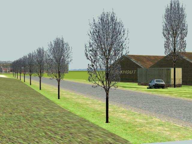
11 Survey Methodology & Material Data Dutch National topographic data Conceptual landscape design of Meerstad Digital photographs Visualizations Abstract 3D Analyst Extension of ArcView (ESRI) Semi realistic 3D StudioMax (Discreet) Realistic PixMaker Pro (PixAround)


12 Survey Methodology & Material
13 Survey Methodology & Material Survey Available as web application Results stored in database Respondents Dienst Landelijk Gebied (DLG) Wageningen University Alterra Spinlab Students Spatial Planning and Design People related to Project Meerstad
14 Survey Data Analysis Response Response Range: respondents Average Response: 31% Population Respondents with visualization experience Respondents without visualization experience Statistical Analysis Percentages of frequencies for each question
15 Survey Edelenbos and Monnikhof (1998) Inform Fifth part of the survey: case situations formulated based on participation levels visualization type selected for each case situation predefined reasons valued with importance (least important most important) Consult Advise Co produce Co decide
16 Survey Results Abstract Semi-realistic Realistic Percentage respondents Inform Consult Advise Co-produce Co-decide Participation levels
17 Survey Results Inform Recognition of the area (both semi realistic and realistic) Readability of the image (realistic) Consult Recognition of the area (both semi realistic and realistic) Readability of the image (semi realistic) Advise Recognition of the area (realistic)
18 Survey Results Co produce Ability to visualize essence of the area (both semi realistic and realistic) Readability of the image (realistic) Co decide Recognition of the area (semi realistic)
19 Survey Results Abstract Semi-realistic Realistic 5 4 Suitability inventory analysis design presentation Planning activities
20 Survey Results Abstract and Semi Realistic visualization types Advantages Less level of detail Ability to visualize spatial problem areas Ability to develop spatial scenarios (current future situation) Disadvantages Interpretation geometric objects
21 Survey Results Realistic visualization type Advantages Recognition of the area Readability of the visualization Ability to make spatial transformation visible (current future situation) Disadvantages Interaction in the visualization (orientation and navigation)
22 Discussion Number of questions too high The Internet as medium to distribute questionnaire not optimal Size of visualization files too large for regular computers Interaction methods still limited to navigation and orientation Inability to directly put feedback into the 3D visualizations Conversion data not optimal
23 Conclusions Survey results indicate that professionals have a varying need for realism during different participation levels Need for semi realistic visualization in levels of inform, advise and co produce Need for realistic visualizations in levels of consult and co decide Professionals consider realistic visualization type suitable for inventory and presentation activities
24 Recommendations Same research with more respondents Same research with other participants in planning process Research on other requirements of visualizations Research on visualizations with another degree of realism
25 Research Questions?
WAGENINGEN. Centre for Geo-Information. Thesis Report GIRS Panorama Meerstad DWK The use of virtual reality in spatial planning
 Centre for Geo-Information Thesis Report GIRS-2003-34 Panorama Meerstad DWK-358-230180 The use of virtual reality in spatial planning A study on realism requirements in the levels of public participation
Welcome to NR502 GIS Applications in Natural Resources. You can take this course for 1 or 2 credits. There is also an option for 3 credits.
 Welcome to NR502 GIS Applications in Natural Resources. You can take this course for 1 or 2 credits. There is also an option for 3 credits. The 1st credit consists of a series of readings, demonstration,
ArcGIS Urban: An Introduction. Lisa Staehli ArcGIS Urban Team Product Development Brooks Patrick ArcGIS Urban Team Business Development
 ArcGIS Urban: An Introduction Lisa Staehli ArcGIS Urban Team Product Development Brooks Patrick ArcGIS Urban Team Business Development Our Cities Are Facing Massive Challenges Our Cities Are Facing Massive
Lecture 2. Introduction to ESRI s ArcGIS Desktop and ArcMap
 Lecture 2 Introduction to ESRI s ArcGIS Desktop and ArcMap Outline ESRI What is ArcGIS? ArcGIS Desktop ArcMap Overview Views Layers Attribute Tables Help! Scale Tips and Tricks ESRI Environmental Systems
Transportation and Logistics Planning and Development Mapping Tool
 Transportation and Logistics Planning and Development Mapping Tool Doreen Gonzales-Gaboyan Business Development and Outreach Center for Innovation through Visualization and Simulation (CIVS) Purdue University
A Preliminary Model of Community-based Integrated Information System for Urban Spatial Development
 A Preliminary Model of Community-based Integrated Information System for Urban Spatial Development Bauni HAMID 1, Devin DEFRIZA 2 1 2 CAITAD (Center of Applied Information Technology in Planning and Design),
A Two-Way Workflow for Integrating CAD, 3D Visualization and Spatial Analysis in a GIS Environment
 A Two-Way Workflow for Integrating CAD, 3D Visualization and Spatial Analysis in a GIS Environment Dirk TIEDE and Thomas BLASCHKE 1 Introduction 3D visualization in spatial planning and especially in landscape
Large Scale Mapping Policy for the Province of Nova Scotia
 Large Scale Mapping Policy for the Province of Nova Scotia December, 2005 Version 1.0 TABLE OF CONTENTS PAGE BACKGROUND...3 POLICY...5 Policy 1.0 Large Scale Mapping Program...5 Policy 2.0 Service Offering...5
Identifying Audit, Evidence Methodology and Audit Design Matrix (ADM)
") 11 Identifying Audit, Evidence Methodology and Audit Design Matrix (ADM) 27/10/2012 Exercise XXX 2 LEARNING OBJECTIVES At the end of this session participants will be able to: 1. Identify types and sources
11 Identifying Audit, Evidence Methodology and Audit Design Matrix (ADM) 27/10/2012 Exercise XXX 2 LEARNING OBJECTIVES At the end of this session participants will be able to: 1. Identify types and sources
New Methods for GeoDesign with ArcGIS and CityEngine. Dr. Özgür Ertac, Prof. Dr. Jörg Schaller, Cristina Mattos Tech. Uni. Munich, Esri Germany
 New Methods for GeoDesign with ArcGIS and CityEngine Dr. Özgür Ertac, Prof. Dr. Jörg Schaller, Cristina Mattos Tech. Uni. Munich, Esri Germany Agenda Evolution in 3D Introduction 3D Across the ArcGIS Platform
GEOGRAPHIC INFORMATION SYSTEM ANALYST I GEOGRAPHIC INFORMATION SYSTEM ANALYST II
 CITY OF ROSEVILLE GEOGRAPHIC INFORMATION SYSTEM ANALYST I GEOGRAPHIC INFORMATION SYSTEM ANALYST II DEFINITION To perform professional level work in Geographic Information Systems (GIS) management and analysis;
GIS Needs Assessment. for. The City of East Lansing
 GIS Needs Assessment for The City of East Lansing Prepared by: Jessica Moy and Richard Groop Center for Remote Sensing and GIS, Michigan State University February 24, 2000 Executive Summary At the request
D.T2.2.2 Methodological model for an integrated monitoring system D.T METHODOLOGICAL MODEL FOR AN INTEGRATED MONITORING SYSTEM
 D.T.2.2.2. METHODOLOGICAL MODEL FOR AN INTEGRATED MONITORING SYSTEM PP7 SPECTRA 04 2018 1 1.1 1.2 1.3 INDEX FOREWORD p.7 CHAPTER 1 FIRST STAGE p.13 CHAPTER 2 DATA COLLECTING 2.1 Selection of the monitored
Brazil Paper for the. Second Preparatory Meeting of the Proposed United Nations Committee of Experts on Global Geographic Information Management
 Brazil Paper for the Second Preparatory Meeting of the Proposed United Nations Committee of Experts on Global Geographic Information Management on Data Integration Introduction The quick development of
Data Origin. Ron van Lammeren CGI-GIRS 0910
 Data Origin Ron van Lammeren CGI-GIRS 0910 How to obtain geodata? Geo data initiative Executive Order 12906, "Coordinating Geographic Data Acquisition and Access: The National Spatial Data Infrastructure,"
Data Origin. How to obtain geodata? Ron van Lammeren CGI-GIRS 0910
 Data Origin How to obtain geodata? Ron van Lammeren CGI-GIRS 0910 Spatial Data interest Improvement of policy making. ± 90% of all information used by government has spatial characteristics SPATIAL INFORMATION
Master Syllabus Department of Geography GEOG 448: Geographic Information System Design Course Description
 Master Syllabus Department of Geography GEOG 448: Geographic Information System Design Course Description Geographic information technologies continue to drive the representation and management of complex
Diffusion of GIS in Public Policy Doctoral Program
 Diffusion of GIS in Public Policy Doctoral Program By Fulbert Namwamba PhD Southern University This presentation demonstrate how GIS was introduced in the Public Policy Doctoral Program at Southern University,
Developing and Applying a User-friendly Web-based GIS for Participative Environmental Assessment
 Developing and Applying a User-friendly Web-based GIS for Participative Environmental Assessment A. Gonzalez, A. Gilmer, R. Foley, J. Sweeney & J. Fry Department of Environment & Planning, Dublin Institute
Scenario development for reaching urban and environmental planning integration in the context of climate change*.
 Scenario development for reaching urban and environmental planning integration in the context of climate change*. PhD (cand) Verónica Zagare (TUDelft, ) Dr. Diego Sepúlveda Carmona (TUDelft) September
Pierce Cedar Creek Institute GIS Development Final Report. Grand Valley State University
 Pierce Cedar Creek Institute GIS Development Final Report Grand Valley State University Major Goals of Project The two primary goals of the project were to provide Matt VanPortfliet, GVSU student, the
Innovative Geographic Visualization for Improved Understanding and Effective Public Participation in Environmental Policy Making and Implementation.
 COMMENTARY Innovative Geographic Visualization for Improved Understanding and Effective Public Participation in Environmental Policy Making and Implementation. Arun Kumar. A 1 *, Tanvi Gaur 2, Sujata Upgupta
4. GIS Implementation of the TxDOT Hydrology Extensions
 4. GIS Implementation of the TxDOT Hydrology Extensions A Geographic Information System (GIS) is a computer-assisted system for the capture, storage, retrieval, analysis and display of spatial data. It
GIS PLANNING FOR MILITARY OPERATIONS
 International Conference for ESRI Users 2015 July 20 24, 2015 San Diego, California. USA GIS PLANNING FOR MILITARY OPERATIONS JOSE LUIS PAYARES VARELA ANDRES CARVAJAL DÍAZ FERNANDO AFANADOR FRANCO DEPARTMENT
Implementing the Sustainable Development Goals: The Role of Geospatial Technology and Innovation
 Fifth High Level Forum on UN Global Geospatial Information Management Implementing the Sustainable Development Goals: The Role of Geospatial Technology and Innovation 28-30 November 2017 Sheraton Maria
An Internet-based Agricultural Land Use Trends Visualization System (AgLuT)
") An Internet-based Agricultural Land Use Trends Visualization System (AgLuT) Prepared for Missouri Department of Natural Resources Missouri Department of Conservation 07-01-2000-12-31-2001 Submitted by
An Internet-based Agricultural Land Use Trends Visualization System (AgLuT) Prepared for Missouri Department of Natural Resources Missouri Department of Conservation 07-01-2000-12-31-2001 Submitted by
Sistema de Informacion Geografica Peninsular de Yucatan (SIGPY): WORK PLAN for the UQROO- URI GIS Development Project
: WORK PLAN for the UQROO- URI GIS Development Project") Sistema de Informacion Geografica Peninsular de Yucatan (SIGPY): WORK PLAN for the UQROO- URI GIS Development Project Eddie Ellis, UQROO 2001 Citation: Quintana Roo, Mexico: Universidad de Quintana Roo
Sistema de Informacion Geografica Peninsular de Yucatan (SIGPY): WORK PLAN for the UQROO- URI GIS Development Project Eddie Ellis, UQROO 2001 Citation: Quintana Roo, Mexico: Universidad de Quintana Roo
EBA Engineering Consultants Ltd. Creating and Delivering Better Solutions
 EBA Engineering Consultants Ltd. Creating and Delivering Better Solutions ENHANCING THE CAPABILITY OF ECOSYSTEM MAPPING TO SUPPORT ADAPTIVE FOREST MANAGEMENT Prepared by: EBA ENGINEERING CONSULTANTS LTD.
Smart Cities and Urban Governance. The urbanapi Project: Bologna Case Study David C. Ludlow, Maria Paola Mauri, Chiara Caranti
 1 ABSTRACT Smart Cities and Urban Governance. The urbanapi Project: Bologna Case Study David C. Ludlow, Maria Paola Mauri, Chiara Caranti (David C. Ludlow, UWE University of the West of England, Bristol-
Geostatistics and Spatial Scales
 Geostatistics and Spatial Scales Semivariance & semi-variograms Scale dependence & independence Ranges of spatial scales Variable dependent Fractal dimension GIS implications Spatial Modeling Spatial Analysis
Geo-identification and pedestrian navigation with geo-mobile applications: how do users proceed?
 TU Vienna presentation 17 th July 2008 Geo-identification and pedestrian navigation with geo-mobile applications: how do users proceed? Ioannis Delikostidis Corné van Elzakker INTERNATIONAL INSTITUTE FOR
NR402 GIS Applications in Natural Resources
 NR402 GIS Applications in Natural Resources Lesson 1 Introduction to GIS Eva Strand, University of Idaho Map of the Pacific Northwest from http://www.or.blm.gov/gis/ Welcome to NR402 GIS Applications in
INTRODUCTION TO GIS. Dr. Ori Gudes
 INTRODUCTION TO GIS Dr. Ori Gudes Outline of the Presentation What is GIS? What s the rational for using GIS, and how GIS can be used to solve problems? Explore a GIS map and get information about map
Open Cities Project. The World Bank, South Asia Region. Background
 Open Cities Project The World Bank, South Asia Region Opencitiesproject.com Background The World Bank s South Asia Region (SAR) is proud to announce its new Open Cities Project. The goal of this project
ZFL, Center of Remote Sensing of Land Surfaces, University of Bonn, Germany. Geographical Institute, University of Bonn, Germany
 Communication of Research Results The IMPETUS Atlas H.-P. Thamm 1, M. Judex 1, O.Schultz 2, S.Krüger 1 & M. Christoph 3 1 ZFL, Center of Remote Sensing of Land Surfaces, University of Bonn, Germany 2 Geographical
GEOG 508 GEOGRAPHIC INFORMATION SYSTEMS I KANSAS STATE UNIVERSITY DEPARTMENT OF GEOGRAPHY FALL SEMESTER, 2002
 GEOG 508 GEOGRAPHIC INFORMATION SYSTEMS I KANSAS STATE UNIVERSITY DEPARTMENT OF GEOGRAPHY FALL SEMESTER, 2002 Course Reference #: 13210 Meeting Time: TU 2:05pm - 3:20 pm Meeting Place: Ackert 221 Remote
LRS Task Force June 13, REVISION HISTORY
 North Carolina Department of Transportation Geographic Information Systems (GIS) Unit LINEAR REFERENCING SYSTEM (LRS) PROJECT DEFINITION Version 1.0 REVISION HISTORY Date Document Manager Revision Purpose
2018/1 The integration of statistical and geospatial information. The Regional Committee of UN-GGIM: Americas:
 The following are the conclusions and recommendations of the Regional Committee of the United Nations on Global Geospatial Information Management for the Americas, during its Fifth Session, Thursday 8
THE USE OF GIS IN VISUAL LANDSCAPE MANAGEMENT AND VISUAL IMPACT ASSESSMENT OF A QUARRY IN PORTUGAL
 Ramos, B. and Panagopoulos, T. 2004. The use of GIS in visual landscape management and visual impact assessment of a quarry in Portugal. Proceedings of the 8 th International conference on Environment
DP Project Development Pvt. Ltd.
 Dear Sir/Madam, Greetings!!! Thanks for contacting DP Project Development for your training requirement. DP Project Development is leading professional training provider in GIS technologies and GIS application
Construction in my Neighborhood - Communication with Stakeholder and Public -
 Construction in my Neighborhood - Communication with Stakeholder and Public - Presented by: Navneet Virk East Bay Municipal Utility District, Oakland, CA 0 Mission at EBMUD To manage the natural resources
7 GEOMATICS BUSINESS SOLUTIONS - ANNUAL REPORT 2006
 7 GEOMATICS BUSINESS SOLUTIONS - ANNUAL REPORT 2006 The Planning and Economic Development Committee recommends the adoption of the recommendation contained in the following report November 30, 2006, from
Putting the U.S. Geospatial Services Industry On the Map
 Putting the U.S. Geospatial Services Industry On the Map December 2012 Definition of geospatial services and the focus of this economic study Geospatial services Geospatial services industry Allow consumers,
GeoHealth Applications Platform ESRI Health GIS Conference 2013
 GeoHealth Applications Platform ESRI Health GIS Conference 2013 Authors Thomas A. Horan, Ph.D. Professor, CISAT Director April Moreno Health GeoInformatics Ph.D. Student Brian N. Hilton, Ph.D. Clinical
Popular Mechanics, 1954
 Introduction to GIS Popular Mechanics, 1954 1986 $2,599 1 MB of RAM 2017, $750, 128 GB memory, 2 GB of RAM Computing power has increased exponentially over the past 30 years, Allowing the existence of
Features and Benefits
 Autodesk LandXplorer Features and Benefits Use the Autodesk LandXplorer software family to help improve decision making, lower costs, view and share changes, and avoid the expense of creating physical
Variation of geospatial thinking in answering geography questions based on topographic maps
 Variation of geospatial thinking in answering geography questions based on topographic maps Yoshiki Wakabayashi*, Yuri Matsui** * Tokyo Metropolitan University ** Itabashi-ku, Tokyo Abstract. This study
ArcGIS for Desktop. ArcGIS for Desktop is the primary authoring tool for the ArcGIS platform.
 ArcGIS for Desktop ArcGIS for Desktop ArcGIS for Desktop is the primary authoring tool for the ArcGIS platform. Beyond showing your data as points on a map, ArcGIS for Desktop gives you the power to manage
No. of Days. Building 3D cities Using Esri City Engine ,859. Creating & Analyzing Surfaces Using ArcGIS Spatial Analyst 1 7 3,139
 Q3 What s New? Creating and Editing Data with ArcGIS Pro Editing and Maintaining Parcels Using ArcGIS Spatial Analysis Using ArcGIS Pro User Workflows for ArcGIS Online Organizations Q3-2018 ArcGIS Desktop
Interactive Visualization Tool (InViTo)
") Interactive Visualization Tool (InViTo) Stefano Pensa To cite this report: Stefano Pensa (2012) Interactive Visualization Tool (InViTo), in Angela Hull, Cecília Silva and Luca Bertolini (Eds.) Accessibility
Interactive Visualization Tool (InViTo) Stefano Pensa To cite this report: Stefano Pensa (2012) Interactive Visualization Tool (InViTo), in Angela Hull, Cecília Silva and Luca Bertolini (Eds.) Accessibility
State and National Standard Correlations NGS, NCGIA, ESRI, MCHE
 GEOGRAPHIC INFORMATION SYSTEMS (GIS) COURSE DESCRIPTION SS000044 (1 st or 2 nd Sem.) GEOGRAPHIC INFORMATION SYSTEMS (11, 12) ½ Unit Prerequisite: None This course is an introduction to Geographic Information
NRS 509 Applications of GIS for Environmental Spatial Data Analysis Project. Fall 2005
 NRS 509 Applications of GIS for Environmental Spatial Data Analysis Project. Fall 2005 GIS in Urban and Regional Transportation Planning Alolade Campbell Department of Civil and Environmental Engineering
RGIS. The city of Roslyn, along with other communities in the central valleys of. Innovator. Breaking Down Barr iers.
 January 2006 RGIS Land Bulletin of the National Consortium for Rural Geospatial Innovations Innovator RGIS Pacific Northwest Central Washington University Breaking Down Barr iers Geospatial decision-support
Urban Climate Resilience
 Urban Climate Resilience in Southeast Asia Partnership Project Introduction Planning for climate change is a daunting challenge for governments in the Mekong Region. Limited capacity at the municipal level,
Finding Common Ground Through GIS
 Finding Common Ground Through GIS Matthew Stone, MPH Special Unit for Technical Assistance Chronic Disease and Injury Control California Department of Public Health ESRI Health GIS Conference Scottsdale,
Spatial Analysis Unit
 SESA Social i a and Economicc Spatial Analysis Unit A Genuine Approach to Using Geographic Information for More Effective Government Recipient of: 2005 Newfoundland and Labrador Public Service Award of
Lecture 3 GIS outputs. Dr. Zhang Spring, 2017
 Lecture 3 GIS outputs Dr. Zhang Spring, 2017 Model of the course Using and making maps Navigating GIS maps Map design Working with spatial data Geoprocessing Spatial data infrastructure Digitizing File
SRJC Applied Technology 54A Introduction to GIS
 SRJC Applied Technology 54A Introduction to GIS Overview Lecture of Geographic Information Systems Fall 2004 Santa Rosa Junior College Presented By: Tim Pudoff, GIS Coordinator, County of Sonoma, Information
GIS and Community Health. GIS and Community Health. Institutional Context and Interests in GIS Development. GIS and Community Health
 GIS and Community Health GIS and Community Health Some critiques of GIS emphasize the potentially harmful social consequences of the diffusion of GIS technology, including reinforcing the power of state
A Framework for Implementing Volunteered Geographic Information Systems
 A Framework for Implementing Volunteered Geographic Information Systems Claus Rinner, Victoria Fast Department of Geography, Ryerson University, Toronto, ON; crinner@ryerson.ca Abstract In an effort to
GIS-Based Sediment Quality Database for the St. Louis River Area of Concern (AOC): Overview Presentations and Demonstration
: Overview Presentations and Demonstration") GIS-Based Sediment Quality Database for the St. Louis River Area of Concern (AOC): Overview Presentations and Demonstration Judy L. Crane 1 and Dawn E. Smorong 2 1 Minnesota Pollution Control Agency, St.
GIS-Based Sediment Quality Database for the St. Louis River Area of Concern (AOC): Overview Presentations and Demonstration Judy L. Crane 1 and Dawn E. Smorong 2 1 Minnesota Pollution Control Agency, St.
GLOBAL GEOPARKS NETWORK
 GLOBAL GEOPARKS NETWORK International Association on Geoparks CELEBRATING EARTH HERITAGE SUSTAINING LOCAL COMMUNITIES REQUEST FOR PROPOSALS Communication & Marketing Strategy FOR UNESCO Global Geoparks
An Internet-Based Integrated Resource Management System (IRMS)
") An Internet-Based Integrated Resource Management System (IRMS) Third Quarter Report, Year II 4/1/2000 6/30/2000 Prepared for Missouri Department of Natural Resources Missouri Department of Conservation
An Internet-Based Integrated Resource Management System (IRMS) Third Quarter Report, Year II 4/1/2000 6/30/2000 Prepared for Missouri Department of Natural Resources Missouri Department of Conservation
esri.com/apps Copyright 2017 Esri. All rights reserved.
 ArcGIS Apps esri.com/apps Copyright 2017 Esri. All rights reserved. 159913 G79379 ArcGIS Apps Survey123 for ArcGIS Included with ArcGIS Survey123 for ArcGIS Create survey style forms to capture accurate
CS 350 A Computing Perspective on GIS
 CS 350 A Computing Perspective on GIS What is GIS? Definitions A powerful set of tools for collecting, storing, retrieving at will, transforming and displaying spatial data from the real world (Burrough,
Quality of Information collected with the help of Map-Based Questionnaires
 Quality of Information collected with the help of Map-Based Questionnaires Contents 1. Introduction 2. Case Studie: The Switch Project in Wilhelmsburg 3. The Web Platform 1. Technical Architecture 2. Interactive
What are the five components of a GIS? A typically GIS consists of five elements: - Hardware, Software, Data, People and Procedures (Work Flows)
") LECTURE 1 - INTRODUCTION TO GIS Section I - GIS versus GPS What is a geographic information system (GIS)? GIS can be defined as a computerized application that combines an interactive map with a database
LECTURE 1 - INTRODUCTION TO GIS Section I - GIS versus GPS What is a geographic information system (GIS)? GIS can be defined as a computerized application that combines an interactive map with a database
GEO-VISUALIZATION TOOLS IN CULTURAL HERITAGE MANAGEMENT
 GEO-VISUALIZATION TOOLS IN CULTURAL HERITAGE MANAGEMENT Elias Grammatikogiannis School of Rural and Surveying Engineering, National Technical University of Athens, 9, Iroon Polytechniou str., 15773 Athens,
Spatial Data Availability Energizes Florida s Citizens
 NASCIO 2016 Recognition Awards Nomination Spatial Data Availability Energizes Florida s Citizens State of Florida Agency for State Technology & Department of Environmental Protection Category: ICT Innovations
Lesson 16: Technology Trends and Research
 http://www.esri.com/library/whitepapers/pdfs/integrated-geoenabled-soa.pdf GEOG DL582 : GIS Data Management Lesson 16: Technology Trends and Research Overview Learning Objective Questions: 1. Why is integration
VGIscience Summer School Interpretation, Visualisation and Social Computing of Volunteered Geographic Information (VGI)
") VGIscience Summer School Interpretation, Visualisation and Social Computing of Volunteered Geographic Information (VGI) TU Dresden, 11.-15. September 2017 Welcome PhD students working on research topics
VGIscience Summer School Interpretation, Visualisation and Social Computing of Volunteered Geographic Information (VGI) TU Dresden, 11.-15. September 2017 Welcome PhD students working on research topics
GIS for the Beginner on a Budget
 GIS for the Beginner on a Budget Andre C. Bally, RLA, GIS Coordinator, Harris County Public Infrastructure Department Engineering Division This presentation, GIS for Beginners on a Budget. will briefly
Your web browser (Safari 7) is out of date. For more security, comfort and. the best experience on this site: Update your browser Ignore
 is out of date. For more security, comfort and. the best experience on this site: Update your browser Ignore") Your web browser (Safari 7) is out of date. For more security, comfort and Activityengage the best experience on this site: Update your browser Ignore Introduction to GIS What is a geographic information
Your web browser (Safari 7) is out of date. For more security, comfort and Activityengage the best experience on this site: Update your browser Ignore Introduction to GIS What is a geographic information
USGIF Essential Body of Knowledge Competency Areas
 GEOINT Job/Practice Analysis USGIF, in consultation with psychometric consultants and the GEOINT community, executed a job/practice analysis to identify common competencies within the GEOINT profession.
about GCC
 about GCC Bldg 234, Flat 11, Al Barakat Street, Hail Al Janaubiyah P.O Box: 94, Postal Code: 123, Al Khaudh, Sultante of Oman Fax : +968 24543188 Mobile :+968 96666445 info@gcc-oman.com www.gcc-oman.com
Chapter 1. GIS Fundamentals
 1. GIS Overview Chapter 1. GIS Fundamentals GIS refers to three integrated parts. Geographic: Of the real world; the spatial realities, the geography. Information: Data and information; their meaning and
Charlene Nielsen, MSc.
 GIS Project Issues Charlene Nielsen, MSc charlene.nielsen@ualberta.ca 492-93979397 B414 BioSci Building www.biology.ualberta.ca/facilities/gis Introduction to GIS in Ecology What a GIS is not What is a
GIS (GEOGRAPHIC INFORMATION SYSTEMS)
") GIS (GEOGRAPHIC INFORMATION SYSTEMS) 1 1. DEFINITION SYSTEM Any organised assembly of resources and procedures united and regulated by interaction or interdependence to complete a set of specific functions.
GIS (GEOGRAPHIC INFORMATION SYSTEMS) 1 1. DEFINITION SYSTEM Any organised assembly of resources and procedures united and regulated by interaction or interdependence to complete a set of specific functions.
Spatial Concepts: Data Models 2
 Spatial Concepts: Data Models 2 2009/2010 CGI GIRS 2/31 Data modeling in 4 steps 1. Geographical perception Continuous phenomenon Discrete phenomena Virtual boundaries Tangible boundaries altitude, EM
A GIS Tool for Modelling and Visualizing Sustainability Indicators Across Three Regions of Ireland
 International Conference on Whole Life Urban Sustainability and its Assessment M. Horner, C. Hardcastle, A. Price, J. Bebbington (Eds) Glasgow, 2007 A GIS Tool for Modelling and Visualizing Sustainability
Spatially Enabled Society
 International Seminar on Land Administration Trends and Issues in Asia and the Pacific Region Spatially Enabled Society Abbas Rajabifard Vice Chair PCGIAP-WG3 Vice-President (President Elect), GSDI Association
THE three-dimensional computer environment is an innovative
 Evaluating Conservation Practices Using GIS and Virtual Reality Modeling Language Troy J. Lively* and George F. Czapar ABSTRACT In order for conservation practices to be installed most effectively, watershed
Web georeference of historical maps
 Vassilios Tsioukas Web georeference of historical maps Keywords: Historical maps, Georeference, Cartography, Cartographic Heritage Summary The creation of an application to perform the geo-referencing
An introduction to ArcGIS Maps for Office. Scott Ball & Mike Flanagan
 An introduction to ArcGIS Maps for Office Scott Ball & Mike Flanagan Main takeaways for today Adding the where to your analysis You can learn a lot when you unlock the power of geography in your analytics
KUNMING FORUM ON UNITED NATIONS GLOBAL GEOSPATIAL INFORMATION MANAGEMENT CITIES OF THE FUTURE: SMART, RESILIENT
 KUNMING FORUM ON UNITED NATIONS GLOBAL GEOSPATIAL INFORMATION MANAGEMENT CITIES OF THE FUTURE: SMART, RESILIENT and SUSTAINABLE Yunnan Zhenzhuang Guest House, Kunming, China 10 12 May 2017 BACKGROUND CONCEPT
ARCHAVE : A Virtual Reality Interface for Archaeological 3D GIS. Master s Thesis Proposal by Daniel Acevedo Feliz
 ARCHAVE : A Virtual Reality Interface for Archaeological 3D GIS Master s Thesis Proposal by Daniel Acevedo Feliz Brown University February 4, 2000 Presentation Outline 1.- Motivation and definitions. Motivation
Public Participatory GIS (ppgis), training & webgis in Mare Nostrum. Anna Spiteri, IRMCo Haifa, Israel, 5th March 2013
, training & webgis in Mare Nostrum. Anna Spiteri, IRMCo Haifa, Israel, 5th March 2013") Public Participatory GIS (ppgis), training & webgis in Mare Nostrum Anna Spiteri, IRMCo Haifa, Israel, 5th March 2013 What is ppgis? Why do we need it? Who participates? Where do we do it? When do we do
Public Participatory GIS (ppgis), training & webgis in Mare Nostrum Anna Spiteri, IRMCo Haifa, Israel, 5th March 2013 What is ppgis? Why do we need it? Who participates? Where do we do it? When do we do
No. of Days. ArcGIS 3: Performing Analysis ,431. Building 3D cities Using Esri City Engine ,859
 What s New? Creating Story Maps with ArcGIS Field Data Collection and Management Using ArcGIS Get Started with Insights for ArcGIS Introduction to GIS Using ArcGIS & ArcGIS Pro: Essential Workflow Migrating
No. of Days. ArcGIS Pro for GIS Professionals ,431. Building 3D cities Using Esri City Engine ,859
 What s New? Creating Story Maps with ArcGIS Field Data Collection and Management Using ArcGIS Get Started with Insights for ArcGIS Introduction to GIS Using ArcGIS & ArcGIS Pro: Essential Workflow Migrating
Esri Training by Microcenter Prepare to Innovate. Microcenter Course Catalog
 Esri Training by Microcenter Prepare to Innovate 2015 Instructor-Led Courses Microcenter Course Catalog ArcGIS Foundational Courses Designed to meet the learning needs of professionals whose GIS experience
Mitsuhiko Kawakami and Zhenjiang Shen Department of Civil Engineering Faculty of Engineering Kanazawa University Japan ABSTRACT
 ABSTRACT Formulation of an Urban and Regional Planning System Based on a Geographical Information System and its Application - A Case Study of the Ishikawa Prefecture Area of Japan - Mitsuhiko Kawakami
Geographic information strategy
 Department for Environment, Food and Rural Affairs Geographic information strategy Methodology JULY 2011 2 Geographic information strategy Methodology This document provides a detailed description of the
Economic and Social Council
 United Nations Economic and Social Council Distr.: General 2 July 2012 E/C.20/2012/10/Add.1 Original: English Committee of Experts on Global Geospatial Information Management Second session New York, 13-15
Sasko Martinovski 1* Abstract. 1. Introduction. Review paper UDC 007:004]:528}:613/614
![Sasko Martinovski 1* Abstract. 1. Introduction. Review paper UDC 007:004]:528}:613/614](/thumbs/90/101776932.jpg "Sasko Martinovski 1* Abstract. 1. Introduction. Review paper UDC 007:004]:528}:613/614") Review paper UDC 007:004]:528}:613/614 DEVELOPING SYSTEMS FOR STRATEGIC PLANNING IN THE HEALTH AND NUTRITION SECTOR BY USING THE GEOGRAPHIC INFORMATION SYSTEM AND ITS APPLICATION IN THE REPUBLIC OF MACEDONIA
Review paper UDC 007:004]:528}:613/614 DEVELOPING SYSTEMS FOR STRATEGIC PLANNING IN THE HEALTH AND NUTRITION SECTOR BY USING THE GEOGRAPHIC INFORMATION SYSTEM AND ITS APPLICATION IN THE REPUBLIC OF MACEDONIA
GIS FOR PLANNING. Course Overview. Schedule. Instructor. Prerequisites. Urban Planning 792 Thursday s 5:30-8:10pm SARUP 158
 GIS FOR PLANNING Urban Planning 792 Thursday s 5:30-8:10pm SARUP 158 Schedule Class/Lab - SARUP 158 Thursdays 5:30pm - 8:10pm Office Hours - By Appointment Project Ideas - Week 4 Final - 5/10/2018 Instructor
An Introduction to Geographic Information System
 An Introduction to Geographic Information System PROF. Dr. Yuji MURAYAMA Khun Kyaw Aung Hein 1 July 21,2010 GIS: A Formal Definition A system for capturing, storing, checking, Integrating, manipulating,
Participatory GIS (PGIS)
") Participatory GIS (PGIS) Join public opinions as an information source into environmental decision-making ESRM 250. May, 29 th, 2012 Mu-Ning Wang wang0209@uw.edu GIS is... A Mapping Tool An Analysis Tool
Participatory GIS (PGIS) Join public opinions as an information source into environmental decision-making ESRM 250. May, 29 th, 2012 Mu-Ning Wang wang0209@uw.edu GIS is... A Mapping Tool An Analysis Tool
Introducing the. a partnership of
 Introducing the a partnership of Background Need for online atlas identified by managers and researchers to make coastal data available Shoreline data Ocean and coastal resources Sea-level rise potential
Course overview. Grading and Evaluation. Final project. Where and When? Welcome to REM402 Applied Spatial Analysis in Natural Resources.
 Welcome to REM402 Applied Spatial Analysis in Natural Resources Eva Strand, University of Idaho Map of the Pacific Northwest from http://www.or.blm.gov/gis/ Where and When? Lectures Monday & Wednesday
Maritime Spatial Planning
 Maritime Spatial Planning The Dutch experience Kopenhagen 28 november 2012 Lodewijk.Abspoel@minienm.nl North Sea 2 Outline History of MSP in the Netherlands Spatial Plan for the Dutch EEZ, principles and