JOINT PUBLIC NOTICE. News Release. Application Number: SPA ABQ Date: March 23, 2018 Comments Due: April 23, 2018
|
|
|
- Beverley Newman
- 5 years ago
- Views:
Transcription

 and the U.S.")
1 JOINT PUBLIC NOTICE Application Number: SPA ABQ Date: March 23, 2018 Comments Due: April 23, 2018 SUBJECT: The U.S. Army Corps of Engineers, Albuquerque District (Corps) and the U.S. Environmental Protection Agency (EPA) are evaluating a permit application from American Gypsum LLC (American Gypsum) to expand its existing operation and continue to extract gypsum from the White Mesa deposit on Pueblo of Zia land. The proposed project would result in impacts to approximately 0.7 acres of waters of the United States and/or navigable waters of the United States (WoUS). This notice is to inform interested parties of the proposed activity and to solicit comments. AUTHORITY: This permit and water quality certification application is being evaluated under Sections 404 and 401 of the Clean Water Act for the discharge of dredged or fill material in WoUS and for compliance with applicable water quality standards. APPLICANT: AGENT: Mr. Ray Dabria American Gypsum Company 4600 Paseo Del Norte Albuquerque, New Mexico ray.dabria@americangypsum.com Mr. Richard Frechette Knight Piesold and Company 1999 Broadway, Suite 600 Denver, CO Phone: (303) rfrechette@knightpiesold.com LOCATION: The Phase III Expansion lies within the 1040-acre Pueblo of Zia Mining Lease held by American Gypsum Company LLC. The lease lies on White Mesa, 2.5 miles southwest of the village of San Ysidro and near the junction of U.S. Highway 550 and State Hwy 4, Sandoval County, New Mexico (latitude , longitude ). News Release
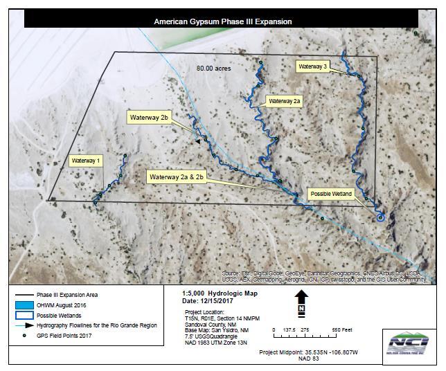
2 PROJECT PURPOSE: Based on the available information, the basic project purpose is mineral resource extraction. The overall project purpose is to continue to extract gypsum from the White Mesa deposit on Pueblo of Zia land. The applicant s stated project purpose is to expand the existing mine to provide gypsum to meet the current local and regional needs for both residential and commercial markets. PROJECT DESCRIPTION: The proposed expansion is contiguous to the current mining operation and would be operated using the existing mining infrastructure. The rate of mining would depend upon demand for gypsum ore, equipment, weather, and other variables. Approximately 1,000 to 3,000 tons per day would be mined from the entire site. No new facilities or equipment are proposed. Expanded mining operations will progress to the south from existing facilities and utilize a Wirtgen Surface Miner (Model 2200SM). The gypsum formation has a natural slope of 3 to 4 percent in the southerly direction; and the actual mine slope will be about 5 to 6 percent. The surface miner has a 7.2 foot-long (2.2-meter) cutting-drum that creates a 6- inch-deep cut on each pass. A front-end loader is then used to push the gypsum into long rows 6 to 7 feet high. The stockpiled gypsum is loaded into haul trucks for transport to either of American Gypsum s two wallboard-manufacturing plants, one in Albuquerque and one in Bernalillo, New Mexico. The trucks haul approximately 30 tons per trip. Water is used for dust control on haul roads and for pre-wetting the mining surface. As the mining surface advances south the upper reaches of four unnamed arroyos will be intersected and filled. These four drainages have been designated as Waterway 1, Waterway 2a, Waterway 2b, and Waterway 3 (see attached maps). Waterway 1 extends approximately 564 linear feet (lf) across the project area, for a total of acres (ac) below the ordinary high water mark (OHWM). Waterway 2a flows into Waterway 2b in the southeast quadrant of the proposed project area. Waterway 2a extends 1,259 lf within the project area before its confluence with Waterway 2b, and the latter extends approximately 1,836 lf prior to their confluence. Waterway 2a encompasses ac below the OHWM and Waterway 2b consists of ac below the OHWM upstream of their confluence. Downstream of their confluence the channel extends another 425 lf prior to exiting the project area, which includes another ac below the OWHM. Waterway 3 extends for 1,752 ac within the mine expansion area, for a total of ac below the OHWM. The impact to these arroyos is the subject of the proposed Clean Water Act 404/401 action. The extraction of gypsum will occur into and below the bottoms of these arroyos. Once the gypseous soil and sand (overburden) have been removed, gypsum, either mined or ripped, will be used to backfill the arroyos so as to provide a relatively level surface for the mining machine. Eventually, the gypsum will be mined within the arroyos to redirect flows to the north and into a collection area. The mining plan of operations is designed to contain all flows within the lease area. ALTERNATIVES: The applicant is required to provide information concerning project alternatives. The Corps will consider all reasonable project alternatives, in particular those which may be less damaging to the aquatic environment. The applicant has considered three onsite alternatives and one off-site alternative, which will be evaluated in addition to the no action alternative. News Release
3 PROPOSED MITIGATION: The Corps requires that applicants consider and use all reasonable and practical measures to avoid and minimize impacts to aquatic resources. If the applicant is unable to avoid or minimize impacts, the Corps may require compensatory mitigation. Compensatory mitigation projects provided to offset losses of aquatic resources must comply with the applicable provisions of 33 CFR Part 332. The applicant has provided a proposal to compensate for direct adverse impacts to WoUS. This compensatory mitigation plan is currently being reviewed by the Corps and the Pueblo of Zia. EVALUATION FACTORS: Regarding the overall Phase III Expansion project, the Bureau of Indian Affairs (BIA) Southern Pueblo Agency is the administrator for the surface and leasing of the mineral trust estate for the Pueblo of Zia. The Bureau of Land Management Rio Puerco Field Office (BLM-RPFO) has oversight for the mining operations. As such, the BIA, BLM, and the Pueblo of Zia will determine if there are any significant environmental impacts associated with the proposed action. It should also be noted that approval for trust minerals are subject to BLM New Mexico State Director Review and the BLM s appeal procedures. The decision whether to issue a 404 permit and 401 certification will be based on an evaluation of the probable environmental impacts, including cumulative impacts, of the described activity on the public interest. That decision will reflect the national concern for both protection and utilization of important resources. The benefit, which reasonably may be expected to accrue from the described activity, must be balanced against its reasonably foreseeable detriments. All factors which may be relevant to the described activity will be considered, including the cumulative effects thereof; among those are conservation, economics, aesthetics, general environmental concerns, wetlands, historic properties, fish and wildlife values, flood hazards, floodplain values, land use, navigation, shoreline erosion and accretion, recreation, water supply and conservation, water quality, energy needs, safety, food and fiber production, mineral needs, consideration of property ownership and, in general, the needs and welfare of the people. The activity's impact on the public interest will include application of the Clean Water Act Section 404(b) (1) guidelines (40 CFR Part 230). HISTORIC PROPERTIES: The project area has been inventoried for cultural resources toward compliance with the National Historic Preservation Act (NHPA). The findings of this investigation are currently being reviewed by the BIA, BLM, Corps, and the Pueblo of Zia s Tribal Historic Preservation Office. ENDANGERED SPECIES: The U.S. Fish and Wildlife Service lists six Threatened, Endangered or Candidate Species with the potential to occur within the project area. However, based on field surveys recently conducted, the project area does not contain potential habitat or Designated Critical Habitat for federallylisted species. FLOODPLAIN MANAGEMENT: The Corps is sending a copy of this public notice to the local floodplain administrator. In accordance with 44 CFR part 60 News Release
4 (Flood Plain Management Regulations Criteria for Land Management and Use), the floodplain administrators of participating communities are required to review all proposed development to determine if a floodplain development permit is required and maintain records of such review. WATER QUALITY CERTIFICATION: The applicant is required to obtain water quality certification, under Section 401 of the Clean Water Act, from the EPA Region 6, Dallas, Texas. Section 401 requires that any applicant for an individual Section 404 permit provide proof of water quality certification to the Corps prior to permit issuance. For any proposed activity on Tribal land that is subject to Section 404 jurisdiction, where the tribe does not have water quality certifying authority, the applicant will be required to obtain water quality certification from the EPA. COMMENT SUBMITTAL AND DEADLINES: The Corps and the EPA are soliciting comments from the public, Federal, State, and local agencies and officials and other interested parties in order to consider and evaluate the impacts of this proposed activity. Any comments received will be considered to determine whether to issue, modify, condition, or deny a permit for this proposal. To make this decision, comments are used to assess impacts on endangered species, historic properties, water quality, general environmental effects, and other public interest factors listed above. Submittal of Section 404 Permit Comments: All comments regarding the 404 permit for the above-described project must be received on or before April 23, 2018, which is the close of the comment period. Extensions of the comment period may be granted for valid reasons provided a written request is received before the date the public comment period ends. If no comments are received by that date, it will be considered that there are no objections. Anyone may request, in writing, that a public hearing be held to consider this application. Requests shall specifically state, with particularity, the reason(s) for holding a public hearing. If the Corps determines that the information received in response to this notice is inadequate for thorough evaluation, a public hearing may be warranted. If a public hearing is warranted, interested parties will be notified of the time, date, and location. Comments on the 404 permit and hearing requests should be submitted to: Chris Parrish Regulatory Project Manager US Army Corps of Engineers, Albuquerque District 4101 Jefferson Plaza NE Albuquerque, NM christopher.m.parrish@usace.army.mil Submittal of Section 401 Water Quality Certification Comments: This document serves to notify the public that EPA will consider issuing a certification under Section 401 of the Clean Water Act. EPA will accept and consider written comments regarding News Release
5 the certification received during the public comment period. Comments may be submitted electronically or by hard copy to: Tom Nystrom Wetlands Enforcement Coordinator U.S. Environmental Protection Agency Region Ross Avenue, Ste 1200 Dallas, TX Nystrom.Thomas@epa.gov Please note that names and addresses of those who submit comments in response to this public notice may be made publicly available through the Freedom of Information Act. DISTRICT ENGINEER ALBUQUERQUE DISTRICT CORPS OF ENGINEERS DIRECTOR WATER QUALITY PROTECTION DIVISION U.S. EPA REGION 6 News Release


6 EXISTING MINE ACTIVITY PROJECT LOCATION PROPOSED PHASE III EXPANSION AREA 2017 DigitalGlobe CNES (2017) Distribution Airbus DS 2017 Microsoft C REFERENCE: AERIAL IMAGE TAKEN FROM BING MAPS. WHITE MESA PROJECT LOCATION REFERENCE: STATE OF NEW MEXICO MAP TAKEN FROM GOOGLE MAPS. STATE OF NEW MEXICO NTS NTS CBEANLAND G:\102\ \CAD\CAD Dept\Figures\Application\Fig1-SiteLocation.dwg 12/12/ :27 AM LAST SAVED BY: DRAWING PATH: PRINTED BY: CHAD BEANLAND, PRINT TIME: PROJECT TITLE CLIENT DESIGNED BY DRAWN BY ACTIVITY CODE CS CB N/A WHITE MESA ACOE 404 PERMIT PHASE III EXPANSION SITE LOCATION MAP AMERICAN GYPSUM COMPANY LOCATION DV102 XREF NUMBER C O N S U L T I N G N/A PROJECT NUMBER FIGURE NUMBER 1 REVISION 0
7 E 1,479,000 E 1,477,500 E 1,476,000 E 1,474,500 E 1,473,000 E 1,471,500 LEGEND: 3777 EXISTING GROUND CONTOUR AND EL, FEET LEASE BOUNDARY ORDINARY HIGH WATER MARK 11 PROPOSED EXPANSION AREA SECTION LINE N 1,651,500 SECTION NUMBER EXISTING MINE ACTIVITY PROPOSED PHASE III EXPANSION AREA N 1,650, N 1,648, NOTES: SCALE BAR MEASURES 3" ON A FULL SIZE PLOT (ANSI-D) AND 1.5" ON A HALF SIZE PLOT (ANSI-B) LAST SAVED BY: CSCHUMACHER DRAWING PATH: G:\102\ \CAD\CAD Dept\Figures\Application\Fig2-GeneralArrangement.dwg PRINTED BY:CATHERINE SCHUMACHER, PRINT TIME:12/18/ :56 AM N 1,647, WHITE MESA ACOE 404 PERMIT PHASE III EXPANSION PROJECT TITLE REFERENCE: EXISTING TOPOGRAPHY WAS RECEIVED FROM AMERICAN GYPSUM ON MARCH 24, ORDINARY HIGH WATER MARK WAS RECEIVED FROM AMERICAN GYPSUM ON FEBRUARY 20, 2017 LEASE BOUNDARY WAS RECEIVED FROM AMERICAN GYPSUM ON MARCH 17, 2017 GENERAL ARRANGEMENT OF EXISTING AND PROPOSED MINE AREAS 800 FEET CLIENT 1"=400' AT FULL SIZE (ANSI D) 1"=800' AT HALF SIZE (ANSI B) AMERICAN GYPSUM COMPANY CONSULTING DESIGNED BY CS LOCATION DRAWN BY CB DV102 ACTIVITY CODE N/A XREF NUMBER PROJECT NUMBER N/A FIGURE NUMBER 2 REVISION 0
8 11


9 PHASE III SOURCE: FEBRURAY 2016, MINING AND RECLAMTION PLAN FOR 86-AC EXPANSION OF THE WHITE MESA GYPSUM MINE CLIENT PROJECT AMERICAN GYPSUM COMPANY WHITE MESA ACOE 404 PERMIT APPLICATION TITLE LAND OWNERSHIP DESIGNED BY DRAWN BY CS CS LOCATION PROJECT NUMBER FIGURE NUMBER REVISION DV / G:\102\ \Deliverables\Reports Specs\404Permit\RevA\Figures\Executables\[Fig3_LandOwnership.xlsx] ACTIVITY CODE N/A XREF NUMBER N/A


10 PHOTOGRAPHIC RECORD WHITE MESA GYPSUM MINE- PHASE III EXPANSION ACOE 404 PERMIT APPLICATION Photo No. 1. Date: May 2017 Description: Wirtgen Surface Miner Photo No. 2. Date: Unknown Description: Mined gypsum stockpiles G:\102\ \Deliverables\Reports Specs\404Permit\RevA\Appendices\Photos.docx Page 1

11 PHOTOGRAPHIC RECORD WHITE MESA GYPSUM MINE- PHASE III EXPANSION ACOE 404 PERMIT APPLICATION Photo No. 3. Date: May 2017 Description: Steep walled arroyo G:\102\ \Deliverables\Reports Specs\404Permit\RevA\Appendices\Photos.docx Page 2
 3933600 3934200 3933000 3933600 3932400 3933000 3931800 3932400 3931200 3931800 3931200 35 30' 36'' N 334600 335200 335800 336400 337000 Map Scale: 1:26,600 if")
12 ' 6'' W ' 57'' W Soil Map Sandoval County Area, New Mexico, Parts of Los Alamos, Sandoval, and Rio Arriba Counties (American Gypsum - White Mesa) ' 36'' N Map Scale: 1:26,600 if printed on A landscape (11" x 8.5") sheet. N Meters 2100 Feet Map projection: Web Mercator Corner coordinates: WGS84 Edge tics: UTM Zone 13N WGS Natural Resources Conservation Service Web Soil Survey National Cooperative Soil Survey ' 6'' W ' 57'' W 35 30' 36'' N 35 32' 38'' N ' 38'' N 9/22/2017 Page 1 of 3
13 Soil Map Sandoval County Area, New Mexico, Parts of Los Alamos, Sandoval, and Rio Arriba Counties (American Gypsum - White Mesa) MAP LEGEND MAP INFORMATION Area of Interest (AOI) Area of Interest (AOI) Soils Soil Map Unit Polygons Soil Map Unit Lines Soil Map Unit Points Special Point Features Blowout Borrow Pit Clay Spot Closed Depression Gravel Pit Gravelly Spot Landfill Lava Flow Marsh or swamp Mine or Quarry Miscellaneous Water Perennial Water Rock Outcrop Saline Spot Sandy Spot Severely Eroded Spot Sinkhole Slide or Slip Sodic Spot Spoil Area Stony Spot Very Stony Spot Wet Spot Other Special Line Features Water Features Streams and Canals Transportation Rails Interstate Highways US Routes Major Roads Local Roads Background Aerial Photography The soil surveys that comprise your AOI were mapped at 1:24,000. Please rely on the bar scale on each map sheet for map measurements. Source of Map: Natural Resources Conservation Service Web Soil Survey URL: Coordinate System: Web Mercator (EPSG:3857) Maps from the Web Soil Survey are based on the Web Mercator projection, which preserves direction and shape but distorts distance and area. A projection that preserves area, such as the Albers equal-area conic projection, should be used if more accurate calculations of distance or area are required. This product is generated from the USDA-NRCS certified data as of the version date(s) listed below. Soil Survey Area: Sandoval County Area, New Mexico, Parts of Los Alamos, Sandoval, and Rio Arriba Counties Survey Area Data: Version 10, Sep 30, 2016 Soil map units are labeled (as space allows) for map scales 1:50,000 or larger. Date(s) aerial images were photographed: Nov 2, 2010 Mar 9, 2017 The orthophoto or other base map on which the soil lines were compiled and digitized probably differs from the background imagery displayed on these maps. As a result, some minor shifting of map unit boundaries may be evident. Natural Resources Conservation Service Web Soil Survey National Cooperative Soil Survey 9/22/2017 Page 2 of 3
14 Soil Map Sandoval County Area, New Mexico, Parts of Los Alamos, Sandoval, and Rio Arriba Counties American Gypsum - White Mesa Map Unit Legend Sandoval County Area, New Mexico, Parts of Los Alamos, Sandoval, and Rio Arriba Counties (NM656) Map Unit Symbol Map Unit Name Acres in AOI Percent of AOI 110 Rock outcrop-saido complex, 5 to 40 percent slopes 111 Rock outcrop-zia complex, 8 to 25 percent slopes 120 Pinavetes loamy sand, 3 to 5 percent slopes 130 Pinavetes-Galisteo, moderately saline, sodic, association, 0 to 5 percent slopes 170 San Mateo loam, 0 to 3 percent slopes 831 Trail loamy sand, 1 to 3 percent slopes, unprotected 1, % % % % % % Totals for Area of Interest 3, % Natural Resources Conservation Service Web Soil Survey National Cooperative Soil Survey 9/22/2017 Page 3 of 3

15 106 50' 35'' W Custom Soil Resource Report Map Hydrologic Soil Group ' 51'' W 35 32' 49'' N 35 30' 19'' N ' 49'' N 35 30' 19'' N ' 35'' W N Map Scale: 1:32,700 if printed on A landscape (11" x 8.5") sheet. Meters Feet Map projection: Web Mercator Corner coordinates: WGS84 Edge tics: UTM Zone 13N WGS ' 51'' W
16 Custom Soil Resource Report MAP LEGEND MAP INFORMATION Area of Interest (AOI) Area of Interest (AOI) Soils Soil Rating Polygons A A/D B B/D C C/D D Not rated or not available Soil Rating Lines A A/D B B/D C C/D D Not rated or not available Soil Rating Points A A/D B B/D C C/D D Not rated or not available Water Features Streams and Canals Transportation Rails Interstate Highways US Routes Major Roads Local Roads Background Aerial Photography The soil surveys that comprise your AOI were mapped at 1:24,000. Please rely on the bar scale on each map sheet for map measurements. Source of Map: Natural Resources Conservation Service Web Soil Survey URL: Coordinate System: Web Mercator (EPSG:3857) Maps from the Web Soil Survey are based on the Web Mercator projection, which preserves direction and shape but distorts distance and area. A projection that preserves area, such as the Albers equal-area conic projection, should be used if more accurate calculations of distance or area are required. This product is generated from the USDA-NRCS certified data as of the version date(s) listed below. Soil Survey Area: Sandoval County Area, New Mexico, Parts of Los Alamos, Sandoval, and Rio Arriba Counties Survey Area Data: Version 11, Sep 6, 2017 Soil map units are labeled (as space allows) for map scales 1:50,000 or larger. Date(s) aerial images were photographed: Nov 2, 2010 Mar 9, 2017 The orthophoto or other base map on which the soil lines were compiled and digitized probably differs from the background imagery displayed on these maps. As a result, some minor shifting of map unit boundaries may be evident. 8
Custom Soil Resource Report for Victoria County, Texas
 United States Department of Agriculture Natural Resources Conservation Service A product of the National Cooperative Soil Survey, a joint effort of the United States Department of Agriculture and other
Custom Soil Resource Report. Soil Map. Map projection: Web Mercator Corner coordinates: WGS84 Edge tics: UTM Zone 14N WGS84. Feet.
 Custom Soil Resource Report Soil Map 3188500 3188700 3188900 3189100 3189300 3189500 3189700 96 43' 30'' W 3188500 3188700 3188900 3189100 3189300 3189500 3189700 96 42' 11'' W 28 48' 59'' N 28 48' 59''
T his map is for illus trative purpos es only and does not repres ent a s urvey. I t is provided 'as is ' without warranty or any repres entation of
 http://montgomerytx.mygisonline.com/print/?extent=2988061.71355584,14087737.6935746,299... 3/2/2017 10:41 AM 20 Montgomery CAD, TX Date Printed: 3 /2 /2017 T his map is for illus trative purpos es only
CRUM RANCH AREA MAP YOLO COUNTY, California, AC +/-
 CRUM RANCH AREA MAP YOLO COUNTY, California, 235.59 AC +/- Map data 2016 Google Imagery 2016, CAPCOG, DigitalGlobe, Texas Orthoimagery Program, U.S. Geological Survey, USDA Farm Service Agency Boundary
CALIFORNIA AGRICULTURAL PR OPERTIES, IN C. GALE RANCH
 CALIFORNIA AGRICULTURAL PR OPERTIES, IN C. GALE RANCH LOCATION: The Ranch is located 6 Yi miles west of the City of Davis on the northwest corner of County Roads 29A and 92E in Yolo County. SIZE: 368.64
RANCHO de DOS PALMAS DAVIS, California, AC +/-
 RANCHO de DOS PALMAS DAVIS, California, 507.28 AC +/- Boundary Transmission Line Pond / Tank Well SCOTT STONE P: (530) 662-4094 sastone57@gmail.com 37874 County Road 28, Woodland, Ca. 95695 The information
Custom Soil Resource Report Soil Map
 78 10' 44'' W Custom Soil Resource Report Soil Map 78 9' 40'' W 40 37' 18'' N 738700 738800 738900 739000 739100 739200 739300 739400 739500 739600 739700 739800 739900 740000 740100 40 37' 18'' N 4499700
FOR SALE. Features Rives Road Petersburg, Virginia Chris Jenkins
 FOR SALE 3513 Rives Road Petersburg, Virginia 23805 Chris Jenkins T 804-228-4928 E cjenkins@ commonwealthcommercial.com Bill Barnett T 804-433-1821 E bbarnett@ commonwealthcommercial.com Features 142±
BUNCOMBE COUNTY NORTH CAROLINA
 PROJECT SITE ² 0 0. 75 1. 5 LOCATION MAP MARCH 2018 2. 25 3 Mil es AID: PROJECT # 2018-01122 18.05301 Sheet 1 of 7 Sources: Esri, HERE, DeLorme, USGS, Intermap, INCREMENT P, NRCan, Esri Japan, METI, Esri
Exhibit RMP-4. Foote Creek Geology and Topography
 Exhibit RMP-4 Foote Creek Geology and Topography Memorandum To: From: CC: Travis Brown, PacifiCorp Daria Drago, P.E., PMP Dr. Deb Luchsinger Date: January 9, 2019 Re: Foote Creek Rim 1 - Geologic Conditions
Soil Map Boulder County Area, Colorado (Planet Blue Grass) Web Soil Survey National Cooperative Soil Survey
 Web Soil Survey National Cooperative Soil Survey") 475910 476000 476090 476180 476270 476360 105 16' 21'' W 476450 476540 476630 476720 476810 4453350 4453440 4453260 4453350 4453170 4453260 4453080 4453170 4453080 475820 475910 4452990 476000 476090 476180
475910 476000 476090 476180 476270 476360 105 16' 21'' W 476450 476540 476630 476720 476810 4453350 4453440 4453260 4453350 4453170 4453260 4453080 4453170 4453080 475820 475910 4452990 476000 476090 476180
Custom Soil Resource Report for Forrest County, Mississippi
 United States Department of Agriculture Natural Resources Conservation Service A product of the National Cooperative Soil Survey, a joint effort of the United States Department of Agriculture and other
CALIFORNIA AGRICULTURAL PR OPERTIES, IN C. BOWLSBEY 320 LIBERTY ISLAND ROAD BUYER: RASSMUSSEN TRUST
 CALIFORNIA AGRICULTURAL PR OPERTIES, IN C. BOWLSBEY 320 LIBERTY ISLAND ROAD SELLER: BOWLSBEY TRUST BUYER: RASSMUSSEN TRUST LOCATION: The Bowlsbey 320 is located ten (10) miles southeast of the City of
Custom Soil Resource Report Soil Map
 121 3' 56'' W Custom Soil Resource Report Soil Map 121 2' 49'' W 45 16' 39'' N 5013800 5014000 5014200 5014400 5014600 5014800 5015000 5015200 5015400 5015600 651800 652000 652200 652400 652600 652800
Web Soil Survey National Cooperative Soil Survey
 121 52' 18'' W Irrigated Capability Class Sutter County, California () 121 51' 49'' W 597600 597700 597800 597900 598000 598100 598200 39 6' 27'' N 39 6' 27'' N 39 5' 57'' N 4328400 4328500 4328600 4328700
Hartmann Ranch. potential vineyard ground acres +/
 Hartmann Ranch potential vineyard ground 95.403 acres +/ Location: Description: Water: Improvements: Crop history This ranch is located on Jefferson Blvd just South of North Courtland Road a few miles
Web Soil Survey National Cooperative Soil Survey
 122 14' 27'' W () 122 13' 37'' W 40 8' 40'' N 564700 564800 564900 565000 565100 565200 565300 565400 565500 565600 565700 565800 40 8' 40'' N 4443400 4443500 4443600 4443700 4443800 4443900 4444000 4443400
TRACT 7: ±252 Acres Irrigated Farmland Grassland
 TRACT 7: ±252 Acres Irrigated Farmland Grassland 1880 FM 2013, Friona, Texas 79035 ±252 acres of irrigated farmland and grassland. This farmland is currently being leased and farmed. The lease agreement
Web Soil Survey National Cooperative Soil Survey
 252500 252600 252700 252800 252900 253000 253100 83 47' 15'' W 83 47' 49'' W Nonirrigated Capability Class Jackson and Owsley Counties, Kentucky (Peggy Wilson Booneville Property - ) 253200 253300 37 25'
Cripps Ranch 76+/- Acres Orchard Development Opportunity Dixon, CA. Presented By:
 Cripps Ranch 76+/- Acres Orchard Development Opportunity Dixon, CA Presented By: Cripps Ranch 76+/- Acres Orchard Development Opportunity Dixon, CA Location: This property is located at 5663 Dally Road
Using the Web Soil Survey Resilience and Resistance Score Sheet Soils Report
 Using the Resilience and Resistance Score Sheet Soils Report 1. Go to http://websoilsurvey.nrcs.usda.gov/app/ and click on the Start WSS button. 2. Create an Area of Interest (AOI) using any of the available
Appendix 2b. NRCS Soil Survey
 Appendix 2b NRCS Soil Survey 118 19' 25'' W Nonirrigated Capability Class Antelope Valley Area, California (Del Sur Solar Site) 118 17' 28'' W 378900 379200 379500 379800 380100 380400 380700 381000 381300
Custom Soil Resource Report for Valley County, Montana
 United States Department of Agriculture Natural Resources Conservation Service A product of the National Cooperative Soil Survey, a joint effort of the United States Department of Agriculture and other
NEWS RELEASE UNDER SECTION 404 OF THE CLEAN WATER ACT (33 USC 1344) ACTION NUMBER SPA ABQ
 ACTION NUMBER SPA ABQ") PUBLIC NOTICE Public Notice Issue Date: //6/07 Albuquerque District Comments due: /6/08 NEWS RELEASE UNDER SECTION 0 OF THE CLEAN WATER ACT ( USC ) ACTION NUMBER SPA-06-00-ABQ BANK STABILIZATION ALONG
PUBLIC NOTICE Public Notice Issue Date: //6/07 Albuquerque District Comments due: /6/08 NEWS RELEASE UNDER SECTION 0 OF THE CLEAN WATER ACT ( USC ) ACTION NUMBER SPA-06-00-ABQ BANK STABILIZATION ALONG
Hydric Rating by Map Unit Harrison County, Mississippi. Web Soil Survey National Cooperative Soil Survey
 89 9' 7'' W 89 8' 38'' W 30 34' 13'' N 30 33' 57'' N 3383480 3383560 3383640 3383720 3383800 3383880 3383960 293640 293720 293800 293880 293960 294040 294120 294200 294280 294360 3383480 3383560 3383640
Custom Soil Resource Report for Multnomah County Area, Oregon
 United States Department of Agriculture Natural Resources Conservation Service A product of the National Cooperative Soil Survey, a joint effort of the United States Department of Agriculture and other
Custom Soil Resource Report for Clackamas County Area, Oregon
 United States Department of Agriculture Natural Resources Conservation Service A product of the National Cooperative Soil Survey, a joint effort of the United States Department of Agriculture and other
Hydric Rating by Map Unit Ocean County, New Jersey (Larsen & N New Prospect Jackson Twp., NJ)
") 74 16' 14'' W Hydric Rating by Map Unit Ocean County, New Jersey ( ) 74 15' 50'' W 40 9' 17'' N 40 8' 53'' N 4444460 4444550 4444640 4444730 4444820 4444910 4445000 4445090 4445180 562120 562210 562300
74 16' 14'' W Hydric Rating by Map Unit Ocean County, New Jersey ( ) 74 15' 50'' W 40 9' 17'' N 40 8' 53'' N 4444460 4444550 4444640 4444730 4444820 4444910 4445000 4445090 4445180 562120 562210 562300
Soil Map Polk County, Florida
 Soil Map Polk County, Florida 28 9' 21'' 28 8' 23'' 3113000 3113200 3113400 3113600 3113800 3114000 3114200 3114400 3114600 81 51' 19'' 81 51' 19'' 416000 416000 ± 416200 416200 68 416400 68 416400 7 13
Custom Soil Resource Report for Clackamas County Area, Oregon
 United States Department of Agriculture Natural Resources Conservation Service A product of the National Cooperative Soil Survey, a joint effort of the United States Department of Agriculture and other
Hydric Rating by Map Unit Harrison County, Mississippi
 89 6' 12'' W 89 5' 54'' W 30 28' 47'' N 30 28' 26'' N 3373210 3373290 3373370 3373450 3373530 3373610 3373690 3373770 3373850 298080 298160 298240 298320 298400 298480 298560 30 28' 47'' N Soil Map may
² 2015 Program Year. Farm Tract McLeod County, Minnesota 1:4, NHEL NHEL
 United States Department of Agriculture McLeod County, Minnesota Farm 5125 #* 2 3.65 NHEL Tract 2762 1 33.19 NHEL ² 2015 Program Year Map Created November 06, 2014 Common Land Unit Cropland Non-cropland
Producing Chandler Walnut Orchard
 AG-LAND Investment Brokers 275 Sale Lane Red Bluff, CA 96080 530-529-4400 Fax 530-527-5042 Producing Chandler Walnut Orchard West Sacramento Avenue - Chico, CA AG-LAND INVESTMENT BROKERS 275 Sale Lane
Web Soil Survey National Cooperative Soil Survey
 95 30' 19'' W Soil Taxonomy Classification Franklin County, Kansas 95 29' 28'' W 38 33' 8'' N 281700 281800 281900 282000 282100 282200 282300 282400 282500 282600 282700 282800 282900 38 33' 8'' N 4269300
Wright County, MN. Overview. Legend
 Wright County, MN Overview 461 ft Legend Roads CSAHCL CTYCL MUNICL PRIVATECL TWPCL Highways Interstate State Hwy US Hwy City/Township Limits c t Subdivisions Parcels Water 2' Contours 842; 844; 846; 848;
Web Soil Survey National Cooperative Soil Survey
 95 27' 24'' W Soil Taxonomy Classification Franklin County, Kansas 95 26' 23'' W 285800 285900 286000 286100 286200 286300 286400 286500 286600 286700 286800 286900 287000 287100 287200 38 29' 34'' N 38
Soil Taxonomy Classification Osage County, Kansas. Web Soil Survey National Cooperative Soil Survey
 95 45' 5'' W Soil Taxonomy Classification Osage County, Kansas 95 44' 3'' W 260300 260400 260500 260600 260700 260800 260900 261000 261100 261200 261300 261400 261500 261600 261700 38 33' 4'' N 38 32'
PARADIGM ODP FORT COLLINS, CO 80525
 DRAINAGE REPORT PARADIGM ODP FORT COLLINS, CO 80525 Prepared For: Paradigm Properties, LLC 2186 Knoll Drive Ventura, CA 93003 Prepared By Coffey Engineering & Surveying 4045 St. Cloud Drive, Suite 180
O\.OLSSON \ ASSOC I ATES
 O\.OLSSON \ ASSOC I ATES NRCS Soils Report Larry D. Knox Juniper Hills Private Landing Strip ) OAProject No. 012-1776 760 Horizon Drive, Suite 1021 Grand Junction, CO 815061 TEL 970.263.7800 I FAX 970.263.7456
Carrick Road $798,000
 1955-2020 Carrick Road 165.76± acres Fayette/Scott Counties $798,000 Offered Exclusively By: Zach Davis Principal Broker +1.859.576.8195 www.kirkfarms.com zach@kirkfarms.com Measuring an appx. 165+/- acres,
Custom Soil Resource Report for St. Lucie County, Florida
 United States Department of Agriculture Natural Resources Conservation Service A product of the National Cooperative Soil Survey, a joint effort of the United States Department of Agriculture and other
Web Soil Survey National Cooperative Soil Survey
 95 40' 40'' W 95 40' 0'' W 38 44' 27'' N 4290200 4290300 4290400 4290500 4290600 4290700 4290800 4290900 4291000 4291100 4291200 4291300 4291400 267300 267400 267500 267600 267700 267800 267900 268000
Soil Taxonomy Classification Jackson County, Florida (Chipola River) Web Soil Survey National Cooperative Soil Survey
 Web Soil Survey National Cooperative Soil Survey") 85 10' 20'' W Soil Taxonomy Classification Jackson County, Florida () 85 9' 8'' W 30 37' 42'' N 30 37' 42'' N 30 37' 2'' N 30 37' 2'' N 85 10' 20'' W N Map Scale: 1:8,740 if printed on A landscape (11"
85 10' 20'' W Soil Taxonomy Classification Jackson County, Florida () 85 9' 8'' W 30 37' 42'' N 30 37' 42'' N 30 37' 2'' N 30 37' 2'' N 85 10' 20'' W N Map Scale: 1:8,740 if printed on A landscape (11"
Soil Taxonomy Classification Washington County, Florida (Pine Log 631A)
") 85 54' 36'' W Soil Taxonomy Classification Washington County, Florida () 85 53' 22'' W 30 25' 42'' N 30 25' 42'' N 30 24' 17'' N 30 24' 17'' N 85 54' 36'' W N Map Scale: 1:12,700 if printed on A portrait
85 54' 36'' W Soil Taxonomy Classification Washington County, Florida () 85 53' 22'' W 30 25' 42'' N 30 25' 42'' N 30 24' 17'' N 30 24' 17'' N 85 54' 36'' W N Map Scale: 1:12,700 if printed on A portrait
Custom Soil Resource Report for Bell County, Texas
 United States Department of Agriculture Natural Resources Conservation Service A product of the National Cooperative Soil Survey, a joint effort of the United States Department of Agriculture and other
Custom Soil Resource Report for Santa Fe Area, New Mexico, Santa Fe County and Part of Rio Arriba County; and Santa Fe County Area, New Mexico
 United States Department of Agriculture Natural Resources Conservation Service A product of the National Cooperative Soil Survey, a joint effort of the United States Department of Agriculture and other
Wetland Delineation. Proposed CVS Pharmacy 9th Street and US Highway 98 (Avenue E) Apalachicola, Franklin County, Florida
 Apalachicola, Franklin County, Florida") Wetland Delineation Proposed CVS Pharmacy 9th Street and US Highway 98 (Avenue E) Apalachicola, Franklin County, Florida August 11, 2016 Terracon Project No. 49167572 Prepared for: Halstead Montgomery,
Wetland Delineation Proposed CVS Pharmacy 9th Street and US Highway 98 (Avenue E) Apalachicola, Franklin County, Florida August 11, 2016 Terracon Project No. 49167572 Prepared for: Halstead Montgomery,
Soil Taxonomy Classification Gadsden County, Florida (Imperial Nursery)
") 84 35' 33'' W 84 38' 3'' W Soil Taxonomy Classification Gadsden County, Florida () 30 32' 17'' N 30 32' 17'' N Map Scale: 1:25,700 if printed on A portrait (8.5" x 11") sheet. N 0 350 700 0 1000 2000 4000
84 35' 33'' W 84 38' 3'' W Soil Taxonomy Classification Gadsden County, Florida () 30 32' 17'' N 30 32' 17'' N Map Scale: 1:25,700 if printed on A portrait (8.5" x 11") sheet. N 0 350 700 0 1000 2000 4000
Custom Soil Resource Report for Clark County, Washington
 United States Department of Agriculture Natural Resources Conservation Service A product of the National Cooperative Soil Survey, a joint effort of the United States Department of Agriculture and other
Custom Soil Resource Report for Potter County, Texas
 United States Department of Agriculture Natural Resources Conservation Service A product of the National Cooperative Soil Survey, a joint effort of the United States Department of Agriculture and other
Hydric Rating by Map Unit Harrison County, Mississippi 30 27' 27'' 30 26' 57''
 Hydric Rating by Map Unit Harrison County, Mississippi 30 27' 27'' 30 26' 57'' 3370400 3370500 3370600 3370700 3370800 3370900 3371000 3371100 3371200 89 2' 40'' 89 2' 41'' 303700 303700 303800 303800
Custom Soil Resource Report for Kern County, California, Northwestern Part
 United States Department of Agriculture Natural Resources Conservation Service A product of the National Cooperative Soil Survey, a joint effort of the United States Department of Agriculture and other
Aperio Property Consultants, llc E. Grand Ave. Aurora, CO Phone (303) Contact: Aaron Thompson
 Contact: Aaron Thompson") Preliminary Development Plan PD Land Suitability Analysis YOUR STORAGE CENTER AT CASTLE ROCK Castle Rock, Colorado PREPARED FOR: YOUR STORAGE CENTER CASTLE ROCK, LLC 2407 Morningview Trail. Castle Rock,
Preliminary Development Plan PD Land Suitability Analysis YOUR STORAGE CENTER AT CASTLE ROCK Castle Rock, Colorado PREPARED FOR: YOUR STORAGE CENTER CASTLE ROCK, LLC 2407 Morningview Trail. Castle Rock,
Custom Soil Resource Report for Solano County, California
 United States Department of Agriculture Natural Resources Conservation Service A product of the National Cooperative Soil Survey, a joint effort of the United States Department of Agriculture and other
Alliance Ag Services, LLC
 United States Department of Agriculture Natural Resources Conservation Service Alliance Ag Services, LLC A product of the National Cooperative Soil Survey, a joint effort of the United States Department
Custom Soil Resource Report for Missoula County Area, Montana
 United States Department of Agriculture Natural Resources Conservation Service A product of the National Cooperative Soil Survey, a joint effort of the United States Department of Agriculture and other
Custom Soil Resource Report for Stevens County, Washington
 United States Department of Agriculture Natural Resources Conservation Service A product of the National Cooperative Soil Survey, a joint effort of the United States Department of Agriculture and other
Custom Soil Resource Report for Fresno County, California, Western Part
 United States Department of Agriculture Natural Resources Conservation Service A product of the National Cooperative Soil Survey, a joint effort of the United States Department of Agriculture and other
Chittenden Road Prune Orchard Corning, California
 AG-LAND INVESTMENT BROKERS 275 Sale Lane / P. O. Box 896 Red Bluff, CA 96080 530.529.4400 office / 530.527.5042 fax Chittenden Road Prune Orchard Corning, California Property: 40.00 acres planted to producing
Custom Soil Resource Report for Polk County, Oregon
 United States Department of Agriculture Natural Resources Conservation Service A product of the National Cooperative Soil Survey, a joint effort of the United States Department of Agriculture and other
Custom Soil Resource Report for Coryell County, Texas
 United States Department of Agriculture Natural Resources Conservation Service A product of the National Cooperative Soil Survey, a joint effort of the United States Department of Agriculture and other
Custom Soil Resource Report for Atlantic County, New Jersey
 United States Department of Agriculture Natural Resources Conservation Service A product of the National Cooperative Soil Survey, a joint effort of the United States Department of Agriculture and other
Aqua Dome Express Car Wash
 Aqua Dome Express Car Wash Stormwater Design Calculations Prepared by: 6997 Professional Parkway East, Suite B Lakewood Ranch, Florida 34240 (941) 444-6644 www.morrisengineering.net Prepared for: Florida
Custom Soil Resource Report for Palo Verde Area, California
 United States Department of Agriculture Natural Resources Conservation Service A product of the National Cooperative Soil Survey, a joint effort of the United States Department of Agriculture and other
Minimum Standards for Wetland Delineations
 Minimum Standards for Wetland Delineations Jason Gipson Chief, Utah/Nevada Regulatory Branch Sacramento District Regulatory Program Workshop 16 Mar 2016 US Army Corps of Engineers Delineation Report Minimum
Custom Soil Resource Report for Southampton County, Virginia
 United States Department of Agriculture Natural Resources Conservation Service A product of the National Cooperative Soil Survey, a joint effort of the United States Department of Agriculture and other
APPROVED JURISDICTIONAL DETERMINATION FORM U.S. Army Corps of Engineers
 APPROVED JURISDICTIONAL DETERMINATION FORM U.S. Army Corps of Engineers This form should be completed by following the instructions provided in Section IV of the JD Form Instructional Guidebook. SECTION
Custom Soil Resource Report for Island County, Washington
 United States Department of Agriculture Natural Resources Conservation Service A product of the National Cooperative Soil Survey, a joint effort of the United States Department of Agriculture and other
Custom Soil Resource Report for Livingston Parish, Louisiana
 United States Department of Agriculture Natural Resources Conservation Service A product of the National Cooperative Soil Survey, a joint effort of the United States Department of Agriculture and other
MVP WMS, George Schorr
 APPROVED JURISDICTIONAL DETERMINATION FORM U.S. Army Corps of Engineers This form should be completed by following the instructions provided in Section IV of the JD Form Instructional Guidebook. SECTION
Custom Soil Resource Report for Clackamas County Area, Oregon
 United States Department of Agriculture Natural Resources Conservation Service A product of the National Cooperative Soil Survey, a joint effort of the United States Department of Agriculture and other
Custom Soil Resource Report for San Luis Obispo County, California, Paso Robles Area
 United States Department of Agriculture Natural Resources Conservation Service A product of the National Cooperative Soil Survey, a joint effort of the United States Department of Agriculture and other
Public Notice. Latitude: Longitude: Minute Quad: Covington, KY
 Public Notice US Army Corps of Engineers Louisville District Public Notice No. LRL-2018-642-cat Date: 9 Aug 2018 Closing Date: 10 Sep 2018 Please address all comments and inquiries to: U.S. Army Corps
 United States Department of Agriculture Natural Resources Conservation Service A product of the National Cooperative Soil Survey, a joint effort of the United States Department of Agriculture and other
Custom Soil Resource Report for Cuyahoga County, Ohio
 United States Department of Agriculture Natural Resources Conservation Service A product of the National Cooperative Soil Survey, a joint effort of the United States Department of Agriculture and other
APPROVED JURISDICTIONAL DETERMINATION FORM U.S. Army Corps of Engineers
 APPROVED JURISDICTIONAL DETERMINATION FORM U.S. Army Corps of Engineers This form should be completed by following the instructions provided in Section IV of the JD Form Instructional Guidebook. SECTION
APPROVED JURISDICTIONAL DETERMINATION FORM U.S. Army Corps of Engineers
 APPROVED JURISDICTIONAL DETERMINATION FORM U.S. Army Corps of Engineers This form should be completed by following the instructions provided in Section IV of the JD Form Instructional Guidebook. SECTION
Custom Soil Resource Report for San Juan Area, Puerto Rico
 United States Department of Agriculture Natural Resources Conservation Service A product of the National Cooperative Soil Survey, a joint effort of the United States Department of Agriculture and other
Custom Soil Resource Report for Clackamas County Area, Oregon
 United States Department of Agriculture Natural Resources Conservation Service A product of the National Cooperative Soil Survey, a joint effort of the United States Department of Agriculture and other
Custom Soil Resource Report for Hamilton County, Texas
 United States Department of Agriculture Natural Resources Conservation Service A product of the National Cooperative Soil Survey, a joint effort of the United States Department of Agriculture and other
Custom Soil Resource Report for Clackamas County Area, Oregon, and Marion County Area, Oregon
 United States Department of Agriculture Natural Resources Conservation Service A product of the National Cooperative Soil Survey, a joint effort of the United States Department of Agriculture and other
SAN FRANCISCO DISTRICT INFORMATION REQUESTED FOR VERIFICATION OF CORPS JURISDICTION
 DEPARTMENT OF THE ARMY SAN FRANCISCO DISTRICT, U.S. ARMY CORPS OF ENGINEERS 1455 MARKET STREET SAN FRANCISCO, CALIFORNIA 94103-1398 SAN FRANCISCO DISTRICT INFORMATION REQUESTED FOR VERIFICATION OF CORPS
Custom Soil Resource Report for Kern County, California, Southwest Part
 United States Department of Agriculture Natural Resources Conservation Service A product of the National Cooperative Soil Survey, a joint effort of the United States Department of Agriculture and other
APPROVED JURISDICTIONAL DETERMINATION FORM U.S. Army Corps of Engineers
 APPROVED JURISDICTIONAL DETERMINATION FORM U.S. Army Corps of Engineers This form should be completed by following the instructions provided in Section IV of the JD Form Instructional Guidebook. SECTION
Sacramento River Farmland Anderson, California
 AG-LAND INVESTMENT BROKERS 275 Sale Lane / P. O. Box 896 Red Bluff, CA 96080 530.529.4400 office / 530.527.5042 fax Sacramento River Farmland Anderson, California Property: 45 +/- acres of farmland with
Custom Soil Resource Report for Wright County, Minnesota
 United States Department of Agriculture Natural Resources Conservation Service A product of the National Cooperative Soil Survey, a joint effort of the United States Department of Agriculture and other
Custom Soil Resource Report for Wasco County, Oregon, Northern Part
 United States Department of Agriculture Natural Resources Conservation Service A product of the National Cooperative Soil Survey, a joint effort of the United States Department of Agriculture and other
Custom Soil Resource Report for Columbus County, North Carolina
 United States Department of Agriculture Natural Resources Conservation Service A product of the National Cooperative Soil Survey, a joint effort of the United States Department of Agriculture and other
Custom Soil Resource Report for Gem County Area, Idaho
 United States Department of Agriculture Natural Resources Conservation Service A product of the National Cooperative Soil Survey, a joint effort of the United States Department of Agriculture and other
APPROVED JURISDICTIONAL DETERMINATION FORM U.S. Army Corps of Engineers
 APPROVED JURISDICTIONAL DETERMINATION FORM U.S. Army Corps of Engineers This form should be completed by following the instructions provided in Section IV of the JD Form Instructional Guidebook. SECTION
APPROVED JURISDICTIONAL DETERMINATION FORM U.S. Army Corps of Engineers
 APPROVED JURISDICTIONAL DETERMINATION FORM U.S. Army Corps of Engineers This form should be completed by following the instructions provided in Section IV of the JD Form Instructional Guidebook. SECTION
Custom Soil Resource Report for Coryell County, Texas
 United States Department of Agriculture Natural Resources Conservation Service A product of the National Cooperative Soil Survey, a joint effort of the United States Department of Agriculture and other
Custom Soil Resource Report for Pinal County, Arizona, Western Part
 United States Department of Agriculture Natural Resources Conservation Service A product of the National Cooperative Soil Survey, a joint effort of the United States Department of Agriculture and other
BEFORE THE HEARING EXAMINER IN AND FOR THE COUNTY OF THURSTON
 BEFORE THE HEARING EXAMINER IN AND FOR THE COUNTY OF THURSTON In the Matter of the Application of FILE NO. SSDP 020135 AAPL 020135 Confederated Tribes of the Chehalis Reservation For a Shoreline Substantial
Connecticut Coastal Management Program
 Connecticut Coastal Management Program Fact Sheet for SHORELINE FLOOD AND EROSION CONTROL STRUCTURES What are Shoreline Flood and Erosion Control Structures? The Connecticut General Statutes (CGS) define
APPROVED JURISDICTIONAL DETERMINATION FORM U.S. Army Corps of Engineers
 APPROVED JURISDICTIONAL DETERMINATION FORM U.S. Army Corps of Engineers This form should be completed by following the instructions provided in Section IV of the JD Form Instructional Guidebook. SECTION
Custom Soil Resource Report for Cumberland County, New Jersey
 United States Department of Agriculture Natural Resources Conservation Service A product of the National Cooperative Soil Survey, a joint effort of the United States Department of Agriculture and other
Custom Soil Resource Report for Polk County, Oregon
 United States Department of Agriculture Natural Resources Conservation Service A product of the National Cooperative Soil Survey, a joint effort of the United States Department of Agriculture and other
EAGLES NEST AND PIASA ISLANDS
 EAGLES NEST AND PIASA ISLANDS HABITAT REHABILITATION AND ENHANCEMENT PROJECT MADISON AND JERSEY COUNTIES, ILLINOIS ENVIRONMENTAL MANAGEMENT PROGRAM ST. LOUIS DISTRICT FACT SHEET I. LOCATION The proposed
Location Restrictions Certification Report NIPSCO Michigan City Generating Station Boiler Slag Pond
 Location Restrictions Certification Report NIPSCO Michigan City Generating Station Boiler Slag Pond Pursuant to: 40 CFR 257.60 40 CFR 257.61 40 CFR 257.62 40 CFR 257.63 40 CFR 257.64 Submitted to: Northern