e-soter Regional pilot platform as EU contribution to a Global Soil Observing System
|
|
|
- Preston Warren
- 5 years ago
- Views:
Transcription
1 e-soter Regional pilot platform as EU contribution to a Global Soil Observing System Enhancing the terrain component in SOTER database Joanna Zawadzka
2 Overview Overview of tested methods for terrain analysis Benchmark datasets New methods Physical entities (hill shed analysis) Homogenous segments (object-based segmentation) Assessment Cramer s V statistic Bayesian Networks Recommendations for e-soter 2
 One of Hammond the ways (Dikau to overcome et al.")

3 Benchmark datasets Methods found in literature SOTER Soter Cook Book (Dobos et al. 2005) One of Hammond the ways (Dikau to overcome et al., the 1992) limitations of grid based Iwahashi methods and is Pike incorporation (2007) of objects into methodology of landform classification Common features: Grid based Search windows of fixed sizes Limitations: Sensitive to grid size Sensitive to window size Scale of the landscape may not be represented by the combination of the two factors 3

4 Physical entities Peak sheds Genrated by hill shed analysis (MacMillan, 2003) Analysis of water flow in the inverted elevation Represent scale of processes in the landscape Hill slope analysis Associated with hill shed analysis Provides polygons representing up to 6 major slope breaks Polygons can be aggregated to target 1: mapping scale Peak sheds Peak sheds + slope breaks 4


5 Homogenous objects Generated from SRTM elevation values using ecognition Developer ESP tool (Dragut et al., 2010) was used to segment elevation values into homogenous objects at 3 levels reflecting various scales of terrain features Level 1 Level 2 Level 3 5
6 Concept of object based approach Dissection of landscape into objects physical entities homogenous objects Basic statistics for each object Elevation, slope K-means analysis higher level of landforms K-means analysis lower level of landforms Refinement to target mapping scale Post-processing Hammond classification scheme 6


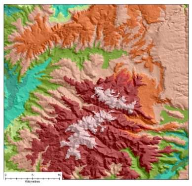
7 Cluster maps based on physical entities Hungarian pilot Chemnitz pilot UK window Moroccan pilot 7


8 Cluster maps based on homogenous objects 8
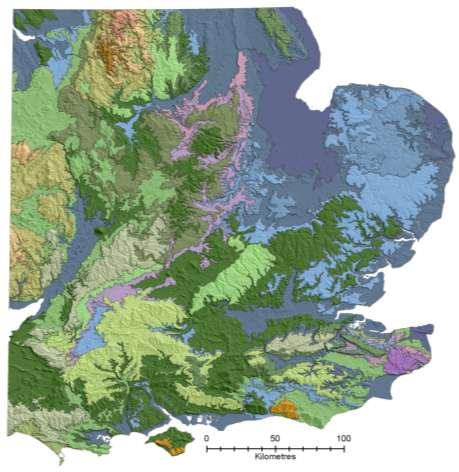
9 Application of Hammond classification scheme Hammond classifiers: Slope occurrence of slope <8% Local relief Profile type occurrence of lowlands Each cluster was characterised with the values of the three classifiers extracted within: peak sheds object-oriented segmentation Three-character code applied to ranges of Hammond classifiers (Dikau et al., 1991) landform subclass Landform class and type assigned to each subclass 9


")
 SOIL")


10 Assessment Validation datasets NATMAP 1:250k (255) SGDBE 1:1mln (64) FAO Soil Map (22) SOIL SOILSCAPE/ LANDSCAPE NATMAP soilscapes 1:250k (27) RCP regions 1:? (76) National Character Areas 1:? (106) 1
11 Assessment Cramer s V Similarity measure between maps of different legends and different Scatterplot 3D number of classes (Rees, 2008) Final Configuration Dimension 1 vs. Dimension 2 vs. Dimension 3 Calculated from contingency tables as: V 2 N (min( n, m) 1) where N n m O ij = observed value NATMAPslscps i E ij = expected value in ith row and jth column Dimension ESM FAOSOIL NTMP 2 ( O E ) / Calculated for pairs of landform datasets and validation datasets LCA Multidimensional scaling of V between a landform dataset and all validation datasets 3 dimension graphs visualising similarity or dissimilarity List of distances in all dimensions Dimension RCP regions Dimension 1 n i j m j O ij ij ij E ij 11
12 Assessment Bayesian Networks Bayesian Belief Networks set to predict validation datasets with the use of various landform maps obtained in the project Sensitivity to findings lists for each validation dataset ordering according to the value of entropy reduction Indication of importance of each landform map Based on a sub-sample of regular points (~300k observations) 12
13 Discussion of validation results Both methods give different but not dissimilar results Bayesian Networks favour approaches based on homogenous objects Cramer s V statistic finds more value in approaches based on physical entities. 13

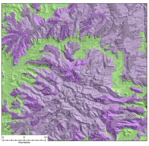
14 Recommended datasets Based on homogenous objects Based on physical entities 14

15 References: Dikau, R., Brabb E. E., Mark R. M., Landform classification of New Mexico by Computer, U.S. Geological Survey Open File Report , Dobos E., Daroussin J., Montanarella L., An SRTM-based procedure to delineate SOTER Terrain Units on 1:1 and 1:5 million scales, EUR EN, 55pp. Office for Official Publications of the European Communities, Luxembourg, Dragut, L., Tiede, D. and Levick, S., ESP: a tool to estimate scale parameters for multiresolution image segmentation of remotely sensed data, International Journal of Geographical Information Science Iwahashi J., Pike R.J., Automated classifications of topography from DEMs by an unsupervised nested-means algorithm and a three-part geometric signature, Geomorphology, 86, , 2007 MacMillan, R. A LandMapR Software Toolkit- C++ Version: Users manual. LandMapper Environmental Solutions Inc., Edmonton, AB. 110 pp. Thank you! 15
e-soter at scale 1: for the Danube Basin Vincent van Engelen
 e-soter at scale 1:250 000 for the Danube Basin Vincent van Engelen Underlying the SOTER methodology is the identification of areas of land with a distinctive, often repetitive, pattern of landform, lithology,
A Comparison of Methods to Incorporate Scale in Geomorphometry
 A Comparison of Methods to Incorporate Scale in Geomorphometry Lucian Drăguţ 1,2, Clemens Eisank 1, Thomas Strasser 1, Thomas Blaschke 1 1 Department of Geography and Geology, University of Salzburg, Hellbrunnerstraße
Refining an Automated Model for Basic Landform Classification
 Refining an Automated Model for Basic Landform Classification An ArcGIS and Python Approach By Josh Moss Patrick Kennelly Academic Advisor What are Landforms? Landforms are categories of structure that
Detecting Characteristic Scales of Slope Gradient
 Detecting Characteristic Scales of Slope Gradient Clemens EISANK and Lucian DRĂGUŢ Abstract Very high resolution (VHR) DEMs such as obtained from LiDAR (Light Detection And Ranging) often present too much
Geomorphology (2012) Contents lists available at SciVerse ScienceDirect. Geomorphology
 Contents lists available at SciVerse ScienceDirect. Geomorphology") Geomorphology 141-142 (2012) 21 33 Contents lists available at SciVerse ScienceDirect Geomorphology journal homepage: www.elsevier.com/locate/geomorph Automated object-based classification of topography
Geomorphology 141-142 (2012) 21 33 Contents lists available at SciVerse ScienceDirect Geomorphology journal homepage: www.elsevier.com/locate/geomorph Automated object-based classification of topography
Using Topography Position Index for Landform Classification (Case study: Grain Mountain)
") Bulletin of Environment, Pharmacology and Life Sciences Bull. Env. Pharmacol. Life Sci., Vol 3 [11] October 2014: 33-39 2014 Academy for Environment and Life Sciences, India Online ISSN 2277-1808 Journal
Bulletin of Environment, Pharmacology and Life Sciences Bull. Env. Pharmacol. Life Sci., Vol 3 [11] October 2014: 33-39 2014 Academy for Environment and Life Sciences, India Online ISSN 2277-1808 Journal
New Digital Soil Survey Products to Quantify Soil Variability Over Multiple Scales
 2006-2011 Mission Kearney Foundation of Soil Science: Understanding and Managing Soil-Ecosystem Functions Across Spatial and Temporal Scales Progress Report: 2006021, 1/1/2007-12/31/2007 New Digital Soil
Global Survey of Organized Landforms: Recognizing Linear Sand Dunes
 Global Survey of Organized Landforms: Recognizing Linear Sand Dunes P. L. Guth 1 1 Department of Oceanography, US Naval Academy 572C Holloway Rd, Annapolis MD 21402 USA Telephone: 00-1-410-293-6560 Fax:
Landform classification using topography position index (case study: salt dome of Korsia-Darab plain, Iran)
") Model. Earth Syst. Environ. (2015) 1:40 DOI 10.1007/s40808-015-0055-9 ORIGINAL ARTICLE Landform classification using topography position index (case study: salt dome of Korsia-Darab plain, Iran) Marzieh
Model. Earth Syst. Environ. (2015) 1:40 DOI 10.1007/s40808-015-0055-9 ORIGINAL ARTICLE Landform classification using topography position index (case study: salt dome of Korsia-Darab plain, Iran) Marzieh
EU-level landslide susceptibility assessment
 in the context t of the Soil Thematic Strategy t Andreas Günther 1, Miet Van Den Eeckhaut 2, Paola Reichenbach h 3, Javier Hervás 2 & Jean-Philippe Malet 4 1 Federal Institute for Geosciences and Natural
Fatmagül Batuk, Ozan Emem Department of Geodesy and Photogrammetry Engineering Tolga Görüm, Erkan Gökaan Natural Sciences Research Center
 Fatmagül Batuk, Ozan Emem Department of Geodesy and Photogrammetry Engineering Tolga Görüm, Erkan Gökaan Natural Sciences Research Center Landforms Landform term as used to denote a portion of the earth
Large Scale Landform Mapping Using Lidar DEM
 ISPRS Int. J. Geo-Inf. 2015, 4, 1336-1345; doi:10.3390/ijgi4031336 Article Large Scale Landform Mapping Using Lidar DEM Türkay Gökgöz * and Moustafa Khalil M. Baker ISPRS International Journal of Geo-Information
GIS APPLICATIONS IN SOIL SURVEY UPDATES
 GIS APPLICATIONS IN SOIL SURVEY UPDATES ABSTRACT Recent computer hardware and GIS software developments provide new methods that can be used to update existing digital soil surveys. Multi-perspective visualization
Preparation of LULC map from GE images for GIS based Urban Hydrological Modeling
 International Conference on Modeling Tools for Sustainable Water Resources Management Department of Civil Engineering, Indian Institute of Technology Hyderabad: 28-29 December 2014 Abstract Preparation
Introduction to GIS I
 Introduction to GIS Introduction How to answer geographical questions such as follows: What is the population of a particular city? What are the characteristics of the soils in a particular land parcel?
AUTOMATIC EXTRACTION OF ALUVIAL FANS FROM ASTER L1 SATELLITE DATA AND A DIGITAL ELEVATION MODEL USING OBJECT-ORIENTED IMAGE ANALYSIS
 AUTOMATIC EXTRACTION OF ALUVIAL FANS FROM ASTER L1 SATELLITE DATA AND A DIGITAL ELEVATION MODEL USING OBJECT-ORIENTED IMAGE ANALYSIS Demetre P. Argialas, Angelos Tzotsos Laboratory of Remote Sensing, Department
INTEGRATION OF GIS AND OBJECT-BASED IMAGE ANALYSIS TO MODEL AND VISUALIZE LANDSCAPES
 INTEGRATION OF GIS AND OBJECT-BASED IMAGE ANALYSIS TO MODEL AND VISUALIZE LANDSCAPES Thomas Blaschke*, Lucian Dragut** * Department of Geography and Geoinformatics, University of Salzburg, Austria, thomas.blaschke@sbg.ac.at
Geography 38/42:376 GIS II. Topic 1: Spatial Data Representation and an Introduction to Geodatabases. The Nature of Geographic Data
 Geography 38/42:376 GIS II Topic 1: Spatial Data Representation and an Introduction to Geodatabases Chapters 3 & 4: Chang (Chapter 4: DeMers) The Nature of Geographic Data Features or phenomena occur as
Comparing Flickr tags to a geomorphometric classification. Christian Gschwend and Ross S. Purves
 Comparing Flickr tags to a geomorphometric classification Christian Gschwend and Ross S. Purves 1 Department of Geography, University of Zurich, Winterthurerstrasse 190, CH 8057 Zurich christian.gschwend@geo.uzh.ch,
STRUCTURAL KNOWLEDGE TO SUPPORT THE GENERALIZATION OF A COASTLINE
 POSTER SESSIONS 279 STRUCTURAL KNOWLEDGE TO SUPPORT THE GENERALIZATION OF A COASTLINE Abstract Sven Arve Saga Statens kartverk (Norwegian Mapping Authority) N-3500 H nefoss, NORWAY e-mail: sven-arve.saga@skripost.md.telemax.no
GeoWEPP Tutorial Appendix
 GeoWEPP Tutorial Appendix Chris S. Renschler University at Buffalo - The State University of New York Department of Geography, 116 Wilkeson Quad Buffalo, New York 14261, USA Prepared for use at the WEPP/GeoWEPP
Object Oriented Classification Using High-Resolution Satellite Images for HNV Farmland Identification. Shafique Matin and Stuart Green
 Object Oriented Classification Using High-Resolution Satellite Images for HNV Farmland Identification Shafique Matin and Stuart Green REDP, Teagasc Ashtown, Dublin, Ireland Correspondence: shafique.matin@teagasc.ie
Digitization in a Census
 Topics Connectivity of Geographic Data Sketch Maps Data Organization and Geodatabases Managing a Digitization Project Quality and Control Topology Metadata 1 Topics (continued) Interactive Selection Snapping
Great Basin. Location: latitude to 42 N, longitude to W Grid size: 925 m. highest elevation)
") The Global Digital Elevation Model (GTOPO30) of Great Basin Location: latitude 38 15 to 42 N, longitude 118 30 to 115 30 W Grid size: 925 m Elevation range: 1,005 3,651 m (rescaled to the interval of 0
The Global Digital Elevation Model (GTOPO30) of Great Basin Location: latitude 38 15 to 42 N, longitude 118 30 to 115 30 W Grid size: 925 m Elevation range: 1,005 3,651 m (rescaled to the interval of 0
ASTER DEM Based Studies for Geological and Geomorphological Investigation in and around Gola block, Ramgarh District, Jharkhand, India
 International Journal of Scientific & Engineering Research, Volume 3, Issue 2, February-2012 1 ASTER DEM Based Studies for Geological and Geomorphological Investigation in and around Gola block, Ramgarh
International Journal of Advance Engineering and Research Development
 Scientific Journal of Impact Factor (SJIF): 4.72 International Journal of Advance Engineering and Research Development Volume 4, Issue 5, May -2017 Watershed Delineation of Purna River using Geographical
An Automated Object-Oriented Satellite Image Classification Method Integrating the FAO Land Cover Classification System (LCCS).
.") An Automated Object-Oriented Satellite Image Classification Method Integrating the FAO Land Cover Classification System (LCCS). Ruvimbo Gamanya Sibanda Prof. Dr. Philippe De Maeyer Prof. Dr. Morgan De
An Automated Object-Oriented Satellite Image Classification Method Integrating the FAO Land Cover Classification System (LCCS). Ruvimbo Gamanya Sibanda Prof. Dr. Philippe De Maeyer Prof. Dr. Morgan De
![)UDQFR54XHQWLQ(DQG'tD]'HOJDGR&](/thumbs/95/125846872.jpg ")UDQFR54XHQWLQ(DQG'tD]'HOJDGR&") &21&(37,21$1',03/(0(17$7,212)$1+
&21&(37,21$1',03/(0(17$7,212)$1+ Automatic mapping of lunar landforms using DEM-derived geomorphometric parameters
 J. Geogr. Sci. 2017, 27(11): 1413-1427 DOI: 10.1007/s11442-017-1443-z 2017 Science Press Springer-Verlag Automatic mapping of lunar landforms using DEM-derived geomorphometric parameters WANG Jiao 1,2,
PROANA A USEFUL SOFTWARE FOR TERRAIN ANALYSIS AND GEOENVIRONMENTAL APPLICATIONS STUDY CASE ON THE GEODYNAMIC EVOLUTION OF ARGOLIS PENINSULA, GREECE.
 PROANA A USEFUL SOFTWARE FOR TERRAIN ANALYSIS AND GEOENVIRONMENTAL APPLICATIONS STUDY CASE ON THE GEODYNAMIC EVOLUTION OF ARGOLIS PENINSULA, GREECE. Spyridoula Vassilopoulou * Institute of Cartography
A novel approach for validating raster datasets with categorical data
 A novel approach for validating raster datasets with categorical data E. Dobos, P. Vadnai, D. Bertóti, & K. Kovács University of Miskolc, Geography Institute, Miskolc-Egyetemváros, 3515. Hungary E. Micheli,
Watershed Delineation
 Watershed Delineation Jessica L. Watkins, University of Georgia 2 April 2009 Updated by KC Love February 25, 2011 PURPOSE For this project, I delineated watersheds for the Coweeta synoptic sampling area
38, Tripoleos Str., Athens , Greece, 23, Velvedou Str., Athens , Greece,
 A Feature Based Accuracy Evaluation of GTOPO30 Miliaresis, G. Ch 1 & Paraschou, C. V. E. 2 Remote Sensing Laboratory, National Technical University of Athens, 1 38, Tripoleos Str., Athens 104-42, Greece,
A Temporal Hydrologic Database for Rapidly Changing Landscapes
 A Temporal Hydrologic Database for Rapidly Changing Landscapes Using Mt. St. Helens in Washington as a Pilot Site Adam Mosbrucker Geog 575 BACKGROUND: Client / User U.S. Geological Survey Cascades Volcano
WERENSKIOLD GLACIER (SW SPITSBERGEN) MORPHOMETRIC CHARACTERISTICS
 MORPHOMETRIC CHARACTERISTICS") WERENSKIOLD GLACIER (SW SPITSBERGEN) MORPHOMETRIC CHARACTERISTICS Abstract Małgorzata Wieczorek Instytut Geografii I Rozwoju Regionalnego Uniwersytet Wrocławski pl. Uniwersytecki 1 50-137 Wrocław POLAND
WERENSKIOLD GLACIER (SW SPITSBERGEN) MORPHOMETRIC CHARACTERISTICS Abstract Małgorzata Wieczorek Instytut Geografii I Rozwoju Regionalnego Uniwersytet Wrocławski pl. Uniwersytecki 1 50-137 Wrocław POLAND
Harmonised approaches for landslide susceptibility mapping in Europe
 Harmonised approaches for landslide susceptibility mapping in Europe J. Hervás Institute for Environment and Sustainability, Joint Research Centre (JRC), European Commission, Ispra, Italy A. Günther Federal
ESTIMATION OF LANDFORM CLASSIFICATION BASED ON LAND USE AND ITS CHANGE - Use of Object-based Classification and Altitude Data -
 ESTIMATION OF LANDFORM CLASSIFICATION BASED ON LAND USE AND ITS CHANGE - Use of Object-based Classification and Altitude Data - Shoichi NAKAI 1 and Jaegyu BAE 2 1 Professor, Chiba University, Chiba, Japan.
Implementation of GIS for Landforms of Southern Marmara
 Fatmagul BATUK, Ozan EMEM, Tolga GORUM and Erkan GOKASAN, Turkey Key Words: Landform Classification, DEM, GIS, North Anatolian Fault Zone (NAFZ), Southern Marmara SUMMARY In this paper; it is aimed to
PAIRING SEMANTICS AND OBJECT-BASED IMAGE ANALYSIS FOR NATIONAL TERRAIN MAPPING - A FIRST-CASE SCENARIO OF CIRQUES
 PAIRING SEMANTICS AND OBJECT-BASED IMAGE ANALYSIS FOR NATIONAL TERRAIN MAPPING - A FIRST-CASE SCENARIO OF CIRQUES S. T. Arundel a a Center of Excellence in Geographic Information Science, U.S. Geological
PRELIMINARY STUDIES ON CONTOUR TREE-BASED TOPOGRAPHIC DATA MINING
 PRELIMINARY STUDIES ON CONTOUR TREE-BASED TOPOGRAPHIC DATA MINING C. F. Qiao a, J. Chen b, R. L. Zhao b, Y. H. Chen a,*, J. Li a a College of Resources Science and Technology, Beijing Normal University,
EMERGENCY PLANNING IN NORTHERN ALGERIA BASED ON REMOTE SENSING DATA IN RESPECT TO TSUNAMI HAZARD PREPAREDNESS
 EMERGENCY PLANNING IN NORTHERN ALGERIA BASED ON REMOTE SENSING DATA IN RESPECT TO TSUNAMI HAZARD PREPAREDNESS Barbara Theilen-Willige Technical University of Berlin, Institute of Applied Geosciences Department
Measuring topographic similarity of toponyms
 Measuring topographic similarity of toponyms Curdin Derungs Department of Geography University of Zürich Winterthurerstr. 190 8057 Zürich, Switzerland curdin.derungs@geo.uzh.ch Ross S. Purves Department
Development of Nationwide Vs30 Map and Calibrated Conversion Table for Indonesia using Automated Topographical Classification
 J. Eng. Technol. Sci., Vol. 49, No. 4, 2017, 457-471 457 Development of Nationwide Vs30 Map and Calibrated Conversion Table for Indonesia using Automated Topographical Classification Masyhur Irsyam 1,2,*,
GeoSUR SRTM 30-m / TPS
 GeoSUR SRTM 30-m / TPS Wm Matthew Cushing (USGS) 16 May 2013 U.S. Department of the Interior U.S. Geological Survey SRTM Mission Shuttle Radar Topography Mission (SRTM) Space Shuttle Endeavour during the
Identification of Very Shallow Groundwater Regions in the EU to Support Monitoring
 Identification of Very Shallow Groundwater Regions in the EU to Support Monitoring Timothy Negley Paul Sweeney Lucy Fish Paul Hendley Andrew Newcombe ARCADIS Syngenta Ltd. Syngenta Ltd. Phasera Ltd. ARCADIS
The Geodatabase Working with Spatial Analyst. Calculating Elevation and Slope Values for Forested Roads, Streams, and Stands.
 GIS LAB 7 The Geodatabase Working with Spatial Analyst. Calculating Elevation and Slope Values for Forested Roads, Streams, and Stands. This lab will ask you to work with the Spatial Analyst extension.
New method of landscape typology in the Czech Republic
 Klasyfikacja krajobrazu. Teoria i praktyka. Problemy Ekologii Krajobrazu. 2008, t. XX. 315-320. New method of landscape typology in the Czech Republic Dušan Romportl, Tomáš Chuman, Zdeněk Lipský Department
Methodological Chain for Hydrological Management with Web-GIS Applications
 Advances in Geosciences Konstantinos Perakis & Athanasios Moysiadis, Editors EARSeL, 2012 Methodological Chain for Hydrological Management with Web-GIS Applications Alexandros Konstantinidis 1, Eleni Tzanou
International Journal of Remote Sensing & Geoscience (IJRSG) ASTER DEM BASED GEOLOGICAL AND GEOMOR-
 ASTER DEM BASED GEOLOGICAL AND GEOMOR-") ASTER DEM BASED GEOLOGICAL AND GEOMOR- PHOLOGICAL INVESTIGATION USING GIS TECHNOLOGY IN KOLLI HILL, SOUTH INDIA Gurugnanam.B, Centre for Applied Geology, Gandhigram Rural Institute-Deemed University, Tamilnadu,
ASTER DEM BASED GEOLOGICAL AND GEOMOR- PHOLOGICAL INVESTIGATION USING GIS TECHNOLOGY IN KOLLI HILL, SOUTH INDIA Gurugnanam.B, Centre for Applied Geology, Gandhigram Rural Institute-Deemed University, Tamilnadu,
KINEROS2/AGWA. Fig. 1. Schematic view (Woolhiser et al., 1990).
.") KINEROS2/AGWA Introduction Kineros2 (KINematic runoff and EROSion) (K2) model was originated at the USDA-ARS in late 1960s and released until 1990 (Smith et al., 1995; Woolhiser et al., 1990). The spatial
KINEROS2/AGWA Introduction Kineros2 (KINematic runoff and EROSion) (K2) model was originated at the USDA-ARS in late 1960s and released until 1990 (Smith et al., 1995; Woolhiser et al., 1990). The spatial
Description of Simandou Archaeological Potential Model. 12A.1 Overview
 12A Description of Simandou Archaeological Potential Model 12A.1 Overview The most accurate and reliable way of establishing archaeological baseline conditions in an area is by conventional methods of
Geo-spatial Analysis for Prediction of River Floods
 Geo-spatial Analysis for Prediction of River Floods Abstract. Due to the serious climate change, severe weather conditions constantly change the environment s phenomena. Floods turned out to be one of
Free Open Source Software for Geoinformatics (FOSS4G) A Practical Example System for Automated Geoscientific Analyses (SAGA)
 A Practical Example System for Automated Geoscientific Analyses (SAGA)") Free Open Source Software for Geoinformatics (FOSS4G) A Practical Example System for Automated Geoscientific Analyses (SAGA) Zlatko Horvat, MSc DGU Područni ured za katastar Čakovec My Motivation Give
Free Open Source Software for Geoinformatics (FOSS4G) A Practical Example System for Automated Geoscientific Analyses (SAGA) Zlatko Horvat, MSc DGU Područni ured za katastar Čakovec My Motivation Give
A landform classification method with G.I.S. for landscape visual analysis purposes
 Sustainable Development and Planning II, Vol. 2 825 A landform classification method with G.I.S. for landscape visual analysis purposes A. Tsouchlaraki Hellenic Open University, Greece Abstract The relief
Land cover classification methods
 Land cover classification methods This document provides an overview of land cover classification using remotely sensed data. We will describe different options for conducting land cover classification
KAAF- GE_Notes GIS APPLICATIONS LECTURE 3
 GIS APPLICATIONS LECTURE 3 SPATIAL AUTOCORRELATION. First law of geography: everything is related to everything else, but near things are more related than distant things Waldo Tobler Check who is sitting
Geometric and Landcover Signatures of Local Authorities in Peloponnesus
 Geometric and Landcover Signatures of Local Authorities in Peloponnesus GEORGE CH. MILIARESIS Department of Geology University of Patras Geology Department, University of Patras, Rion 265-04 GREECE gmiliar@upatras.gr
Basic principals of the manual of procedures (Version 1.1) for the georeferenced soil database of Europe
 for the georeferenced soil database of Europe") Basic principals of the manual of procedures (Version 1.1) for the georeferenced soil database of Europe Finke P., Montanarella L. in Zdruli P. (ed.), Steduto P. (ed.), Lacirignola C. (ed.), Montanarella
Basic principals of the manual of procedures (Version 1.1) for the georeferenced soil database of Europe Finke P., Montanarella L. in Zdruli P. (ed.), Steduto P. (ed.), Lacirignola C. (ed.), Montanarella
Soil parent material delineation using MODIS and SRTM data
 Hungarian Geographical Bulletin 62 (2) (2013) 133 156. Soil parent material delineation using MODIS and SRTM data Endre DOBOS 1, Anna SERES 1, Péter VADNAI 1, Erika MICHÉLI 2, Márta FUCHS 2, Vince LÁNG
ARCGIS PRO COURSE, APPLIED TO ENVIROMENTAL MANAGEMENT GIS. Course. Training. .com
 ARC PRO COURSE, APPLIED TO ENVIROMENTAL MANAGEMENT TYC Training Course.com TRAINING OVERVIEW This Arc Pro online course will provide a great deal of information about the link between earth s ecosystems
Multi scale and multi criteria mapping of mountain peaks as fuzzy entities
 International Journal of Geographical Information Science ISSN: 1365-8816 (Print) 1362-3087 (Online) Journal homepage: http://www.tandfonline.com/loi/tgis20 Multi scale and multi criteria mapping of mountain
A quantitative morphometric comparison of cockpit and doline karst landforms
 J. Geogr. Sci. 2014, 24(6): 1069-1082 DOI: 10.1007/s11442-014-1139-6 2014 Science Press Springer-Verlag A quantitative morphometric comparison of cockpit and doline karst landforms LIANG Fuyuan 1, * DU
Refinement of the OECD regional typology: Economic Performance of Remote Rural Regions
 [Preliminary draft April 2010] Refinement of the OECD regional typology: Economic Performance of Remote Rural Regions by Lewis Dijkstra* and Vicente Ruiz** Abstract To account for differences among rural
Directorate E: Sectoral and regional statistics Unit E-4: Regional statistics and geographical information LUCAS 2018.
 EUROPEAN COMMISSION EUROSTAT Directorate E: Sectoral and regional statistics Unit E-4: Regional statistics and geographical information Doc. WG/LCU 52 LUCAS 2018 Eurostat Unit E4 Working Group for Land
4. GIS Implementation of the TxDOT Hydrology Extensions
 4. GIS Implementation of the TxDOT Hydrology Extensions A Geographic Information System (GIS) is a computer-assisted system for the capture, storage, retrieval, analysis and display of spatial data. It
Watershed Delineation in GIS Environment Rasheed Saleem Abed Lecturer, Remote Sensing Centre, University of Mosul, Iraq
 Watershed Delineation in GIS Environment Rasheed Saleem Abed Lecturer, Remote Sensing Centre, University of Mosul, Iraq Abstract: The management and protection of watershed areas is a major issue for human
Landslide Hazard Assessment Methodologies in Romania
 A Scientific Network for Earthquake, Landslide and Flood Hazard Prevention SciNet NatHazPrev Landslide Hazard Assessment Methodologies in Romania In the literature the terms of susceptibility and landslide
A Help Guide for Using gssurgo to Find Potential Wetland Soil Landscapes
 A Help Guide for Using gssurgo to Find Potential Wetland Soil Landscapes Wetland Mapping Consortium Webinar September 17, 2014 Dr. John M. Galbraith Crop & Soil Environmental Sciences Virginia Tech Wetland
Louisiana Transportation Engineering Conference. Monday, February 12, 2007
 Louisiana Transportation Engineering Conference Monday, February 12, 2007 Agenda Project Background Goal of EIS Why Use GIS? What is GIS? How used on this Project Other site selection tools I-69 Corridor
INTRODUCTION TO GIS. Dr. Ori Gudes
 INTRODUCTION TO GIS Dr. Ori Gudes Outline of the Presentation What is GIS? What s the rational for using GIS, and how GIS can be used to solve problems? Explore a GIS map and get information about map
INSPIRE in the context of EC Directive 2002/49/EC on Environmental Noise
 INSPIRE in the context of EC Directive 2002/49/EC on Environmental Noise Simon Shilton Acustica Ltd, United Kingdom Nigel Jones Extrium Ltd, United Kingdom About the Authors www.acustica.co.uk Acoustics
Landslide Classification: An Object-Based Approach Bryan Zhou Geog 342: Final Project
 Landslide Classification: An Object-Based Approach Bryan Zhou Geog 342: Final Project Introduction One type of natural hazard that people are familiar with is landslide. Landslide is a laymen term use
Digital Elevation Models (DEM)
") Digital Elevation Models (DEM) Digital representation of the terrain surface enable 2.5 / 3D views Rule #1: they are models, not reality Rule #2: they always include some errors (subject to scale and data
Digital Elevation Models (DEM) Digital representation of the terrain surface enable 2.5 / 3D views Rule #1: they are models, not reality Rule #2: they always include some errors (subject to scale and data
MODULE 7 LECTURE NOTES 5 DRAINAGE PATTERN AND CATCHMENT AREA DELINEATION
 MODULE 7 LECTURE NOTES 5 DRAINAGE PATTERN AND CATCHMENT AREA DELINEATION 1. Introduction Topography of the river basin plays an important role in hydrologic modelling, by providing information on different
Landslide susceptibility assessment over Europe according to the Tier 1 approach: Experiment and perspectives
 Landslide susceptibility assessment over Europe according to the Tier 1 approach: Experiment and perspectives Andreas Günther 1 & Paola Reichenbach 2 1 Bundesanstalt für Geowissenschaften und Rohstoffe
USING GIS CARTOGRAPHIC MODELING TO ANALYSIS SPATIAL DISTRIBUTION OF LANDSLIDE SENSITIVE AREAS IN YANGMINGSHAN NATIONAL PARK, TAIWAN
 CO-145 USING GIS CARTOGRAPHIC MODELING TO ANALYSIS SPATIAL DISTRIBUTION OF LANDSLIDE SENSITIVE AREAS IN YANGMINGSHAN NATIONAL PARK, TAIWAN DING Y.C. Chinese Culture University., TAIPEI, TAIWAN, PROVINCE
Model Integration - How WEPP inputs are calculated from GIS data. ( ArcGIS,TOPAZ, Topwepp)
") Model Integration - How WEPP inputs are calculated from GIS data. ( ArcGIS,TOPAZ, Topwepp) ArcGIS 9.1-9.3 Allows user to locate area of interest, assemble grids, visualize outputs. TOPAZ Performs DEM
Model Integration - How WEPP inputs are calculated from GIS data. ( ArcGIS,TOPAZ, Topwepp) ArcGIS 9.1-9.3 Allows user to locate area of interest, assemble grids, visualize outputs. TOPAZ Performs DEM
Landform Classification in Raster Geo-images
 Landform Classification in Raster Geo-images Marco Moreno, Serguei Levachkine, Miguel Torres, and Rolando Quintero Geoprocessing Laboratory-Centre for Computing Research-National Polytechnic Institute,
Criteria for identification of areas at risk of landslides in Europe: the Tier 1 approach
 Criteria for identification of areas at risk of landslides in Europe: the Tier 1 approach Andreas Günther 1, Paola Reichenbach 2, Fausto Guzzetti 2, Andreas Richter 1 1 Bundesanstalt für Geowissenschaften
USE OF RADIOMETRICS IN SOIL SURVEY
 USE OF RADIOMETRICS IN SOIL SURVEY Brian Tunstall 2003 Abstract The objectives and requirements with soil mapping are summarised. The capacities for different methods to address these objectives and requirements
The Evolution of NWI Mapping and How It Has Changed Since Inception
 The Evolution of NWI Mapping and How It Has Changed Since Inception Some Basic NWI Facts: Established in 1974 Goal to create database on characteristics and extent of U.S. wetlands Maps & Statistics In
Global and National Soils and Terrain Digital Databases (SOTER)
") Global and National Soils and Terrain Digital Databases (SOTER) Procedures Manual Version 2.0 DRAFT FOR COMMENTS ISRIC Report 2012/04 ISRIC World Soil Information has a mandate to serve the international
Global and National Soils and Terrain Digital Databases (SOTER) Procedures Manual Version 2.0 DRAFT FOR COMMENTS ISRIC Report 2012/04 ISRIC World Soil Information has a mandate to serve the international
Version 1.1 GIS Syllabus
 GEOGRAPHIC INFORMATION SYSTEMS CERTIFICATION Version 1.1 GIS Syllabus Endorsed 1 Version 1 January 2007 GIS Certification Programme 1. Target The GIS certification is aimed at: Those who wish to demonstrate
Reassessing the conservation status of the giant panda using remote sensing
 SUPPLEMENTARY Brief Communication INFORMATION DOI: 10.1038/s41559-017-0317-1 In the format provided by the authors and unedited. Reassessing the conservation status of the giant panda using remote sensing
An Introduction to Geographic Information System
 An Introduction to Geographic Information System PROF. Dr. Yuji MURAYAMA Khun Kyaw Aung Hein 1 July 21,2010 GIS: A Formal Definition A system for capturing, storing, checking, Integrating, manipulating,
Module 2.1 Monitoring activity data for forests using remote sensing
 Module 2.1 Monitoring activity data for forests using remote sensing Module developers: Frédéric Achard, European Commission (EC) Joint Research Centre (JRC) Jukka Miettinen, EC JRC Brice Mora, Wageningen
These modules are covered with a brief information and practical in ArcGIS Software and open source software also like QGIS, ILWIS.
 Online GIS Training and training modules covered are: 1. ArcGIS, Analysis, Fundamentals and Implementation 2. ArcGIS Web Data Sharing 3. ArcGIS for Desktop 4. ArcGIS for Server These modules are covered
MODELING DEM UNCERTAINTY IN GEOMORPHOMETRIC APPLICATIONS WITH MONTE CARLO-SIMULATION
 MODELING DEM UNCERTAINTY IN GEOMORPHOMETRIC APPLICATIONS WITH MONTE CARLO-SIMULATION Juha Oksanen and Tapani Sarjakoski Finnish Geodetic Institute Department of Geoinformatics and Cartography P.O. Box
NWT Open Report Delineation of Watersheds in the Mackenzie Mountains
 NWT Open Report 2015-007 Delineation of Watersheds in the Mackenzie Mountains K.L. Pierce and H. Falck Recommended Citation: Pierce, K.L. and Falck, H., 2015. Delineation of watersheds in the Mackenzie
Placer Potential Map. Dawson L and U se P lan. Jeffrey Bond. Yukon Geological Survey
 Placer Potential Map Dawson L and U se P lan By Jeffrey Bond Yukon Geological Survey Dawson Land Use Plan Placer Potential Map 1.0 Introduction Placer mining has been an important economic driver within
GIS Viewshed Analysis to Identify Zones of Potential Visual Impact on Protected Landscapes
 GIS Viewshed Analysis to Identify Zones of Potential Visual Impact on Protected Landscapes Background Natural England is consulted by local planning authorities on increasing numbers of development proposals,
Land Surface Processes and Land Use Change. Lex Comber
 Land Surface Processes and Land Use Change Lex Comber ajc36@le.ac.uk Land Surface Processes and Land Use Change Geographic objects in GIS databases Detecting land use change using multitemporal imaging
Landform of Alicante province by using GIS
 International conference on Innovative Methods in Product Design June 15 th 17 th, 2011, Venice, Italy Landform of Alicante province by using GIS Ana Pou Merina (a), Cruz Calleja Perucho (a), Maria Angeles
Compact guides GISCO. Geographic information system of the Commission
 Compact guides GISCO Geographic information system of the Commission What is GISCO? GISCO, the Geographic Information System of the COmmission, is a permanent service of Eurostat that fulfils the requirements
COMBINING ENUMERATION AREA MAPS AND SATELITE IMAGES (LAND COVER) FOR THE DEVELOPMENT OF AREA FRAME (MULTIPLE FRAMES) IN AN AFRICAN COUNTRY:
 FOR THE DEVELOPMENT OF AREA FRAME (MULTIPLE FRAMES) IN AN AFRICAN COUNTRY:") COMBINING ENUMERATION AREA MAPS AND SATELITE IMAGES (LAND COVER) FOR THE DEVELOPMENT OF AREA FRAME (MULTIPLE FRAMES) IN AN AFRICAN COUNTRY: PRELIMINARY LESSONS FROM THE EXPERIENCE OF ETHIOPIA BY ABERASH
COMBINING ENUMERATION AREA MAPS AND SATELITE IMAGES (LAND COVER) FOR THE DEVELOPMENT OF AREA FRAME (MULTIPLE FRAMES) IN AN AFRICAN COUNTRY: PRELIMINARY LESSONS FROM THE EXPERIENCE OF ETHIOPIA BY ABERASH
3 SHORELINE CLASSIFICATION METHODOLOGY
 3 SHORELINE CLASSIFICATION METHODOLOGY Introduction The ESI scale, as described in Section 2, categorizes coastal habitats in terms of their susceptibility to spilled oil, taking into consideration a number
METHODS FOR NATURAL LAND MAPPING UNITS DELINEATION FOR AGRICULTURAL LAND EVALUATION
 Universitatea de Ştiinţe Agricole şi Medicină Veterinară Iaşi METHODS FOR NATURAL LAND MAPPING UNITS DELINEATION FOR AGRICULTURAL LAND EVALUATION Iuliana Cornelia NICULIȚĂ 1, Mihai NICULIȚĂ 1 E-mail: iuliananiculita@geomorphologyonline.com
Characterisation of valleys from DEMs
 18 th World IMACS / MODSIM Congress, Cairns, Australia 13-17 July 2009 http://mssanz.org.au/modsim09 Characterisation of valleys from DEMs Wang, D. 1,2 and Laffan, S.W. 1 1. School of Biological, Earth
INTERNATIONAL JOURNAL OF ENVIRONMENTAL SCIENCES Volume 5, No 1, Copyright by the authors - Licensee IPA- Under Creative Commons license 3.
 INTERNATIONAL JOURNAL OF ENVIRONMENTAL SCIENCES Volume 5, No 1, 2014 Copyright by the authors - Licensee IPA- Under Creative Commons license 3.0 Research article ISSN 0976 4402 Manual and automated delineation
Digital Elevation Models. Using elevation data in raster format in a GIS
 Digital Elevation Models Using elevation data in raster format in a GIS What is a Digital Elevation Model (DEM)? Digital representation of topography Model based on scale of original data Commonly a raster