2015 Hurricane Season BE Ready Brief
|
|
|
- Harold Cook
- 5 years ago
- Views:
Transcription


1 2015 Hurricane Season BE Ready Brief HOMESTEAD ARB OFFICE OF EMERGENCY MANAGEMENT

2 2015 Hurricane Season Outlook Hurricane Season: Atlantic Coast 1 June- 30 November Peak Months are August and September
3 2015 Hurricane Outlook The NOAA forecasts a Below Average Hurricane Season with: 6-11 Named Storms 3-6 Hurricanes 0-2 Major Hurricanes Note: An average hurricane season features about: 7 named storms with 4 of those Cat 1 thru Cat 3 hurricanes With 2 of those becoming major hurricanes Information provided by National Oceanic and Atmospheric Administration (NOAA)
4 2015 Hurricane Season Names Ana Bill Claudette Danny Erika Fred Grace Henri Ida Joaquin Kate Larry Mindy Nicholas Odette Peter Rose Sam Teresa Victor Wanda

5


6 Hurricane Preparations Determine safe evacuation routes inland. Learn locations of official shelters. Before the Hurricane Season Check emergency equipment, such as flashlights, and battery-powered equipment such as cell phones and your Weather Radio All Hazards receiver. Buy plywood or other material to protect your home if you don t already have it. Trim trees and shrubbery so branches don t fly into your home. Clear clogged rain gutters and downspouts. Find pet-friendly hotels on your evacuation route. Stocking extra water at least 1-2 gallons daily per person for 3 days Get a First Aid Kit for the house Stock Non-Perishable Foods Have cash saved and available Highly Recommended to: Get a Land Line Telephone Get a generator Get a grill or a small propane burner
 continuously")


7 Ways to Stay Informed NOAA Weather Radio All Hazards The National Weather Service (NWS) continuously broadcasts warning, watches, forecasts and non-weather related hazard information on NOAA Weather Radio All Hazards (NWR). The average range of the NWR transmitters is 40 miles, depending on topography. For the best performing NWR receivers, NWS suggests you look at devices certified to Public Alert standards. These radios meet specific technical standards and come with many features such as Specific Area Message Encoding (SAME), a battery backup, both audio and visual alarms, selective programming for the types of hazards you want to be warned for, and the ability to activate external alarm devices for people with disabilities. Similar to a smoke detector, an NWR can wake you up in the middle of the night to alert you of a dangerous situation.


8 Ways to Stay Informed Online Current Storm Information National Weather Service: National Hurricane Center: Historical Storm Information National Climatic Data Center: NOAA Coastal Services Center: Emergency/Preparedness Information American Red Cross: FEMA: Other Information NHC advisory s: National Weather Service advisory s: Audio Podcasts: Geographic Information System Data: NOAA Weather Radio All Hazards: Hurricane Tracking Charts: Mobile NHC and NWS Information Mobile NHC website in basic HTML: Mobile NHC website in WAP format: Mobile NWS website in basic HTML: Mobile NWS website in WAP format: Homestead ARB
 415-7777 Command Post: (786) 415-7023")


9 Important Numbers Fire Department / Security Desk: (786) Command Post: (786) Installation Status Line: (786) The installation status line will provide you with the current status of the base and instructions on what to do (i.e. base evacuations, base closure, when to return back to base, and etc.)

10 AFPASS Open to USAF military, civilians, contractors AND family members Reports Accountability Provides life saving information Provides Location information Call to get Family needs such as: Water Food Shelter information Medical

11 Relatives/Friends Hotel/Motel Local County Shelters PLAN NOW!!! Find your Evacuation Sites
. Prepare to cover all windows and doors with shutters or other shielding materials.")
12 Hurricane Preparations When in a Watch Area Frequently listen to radio, TV or NOAA Weather Radio All Hazards for official bulletins of the storm s progress. Fuel and service family vehicles. Ensure you have extra cash on hand (ATMs may not work). Prepare to cover all windows and doors with shutters or other shielding materials. Check batteries and stock up on canned food, first aid supplies, drinking water and medications. Bring in light-weight objects such as garbage cans, garden tools, toys and lawn furniture. Plan to Leave if You... Prior to the Storm Live in a mobile home. They are unsafe in high winds no matter how well fastened to the ground. When in a Warning Area Closely monitor radio, TV or NOAA Weather Radio All Hazards for official bulletins. Close storm shutters. Live in a high rise building. Hurricane winds are stronger at higher elevations. Live on the coastline, an offshore island or near a river or a flood plain. Follow instructions issued by local officials. Leave immediately if ordered! DO NOT stay in a mobile or manufactured home. Notify neighbors and a family member outside of the warned area of your evacuation plans. Take pets with you if possible. NOTE: Most public shelters do not allow pets other than certified Service Animals.


 Battery-powered radio Cell Phone (with")


13 Hurricane Preparations What to Bring to a Shelter Personal First-aid kit Medication (Prescription) Baby food and diapers Games, books, music players with headphones Toiletries (toothbrush, feminine items, razor, etc.) Battery-powered radio Cell Phone (with charger) Flashlight(s) Extra batteries A blanket or sleeping bag for each person Identification Copies of key papers such as insurance policies Cash, credit card REMINDER: If you are told to leave your home, do so immediately!
 Turn off utilities if told to do so by authorities. Turn off propane tanks. Unplug small appliances.")
14 Hurricane Preparations During the Storm If Staying in a Home... Turn refrigerator to maximum cold and keep it closed. (Turns Fridge into a cooler in case of power outage) Turn off utilities if told to do so by authorities. Turn off propane tanks. Unplug small appliances. Fill bathtub and large (CLEAN) containers with water in case clean tap water is unavailable. Use water in bathtubs for cleaning and flushing only. Do NOT drink it. If Winds Become Strong... Stay away from windows and doors, even if they are covered. Take refuge in a small interior room, closet or hallway. Close all interior doors. Secure and brace external doors. If you are in a two-story house, go to an interior first floor room. If you are in a multi-story building and away from water, go to the 1st or 2nd floor and stay in the halls or other interior rooms away from windows. Lie on the floor under a table or other sturdy object. (To protect from debris) Be Alert For... Tornadoes they are often spawned by hurricanes. The calm eye of the storm it may seem like the storm is over, but after the eye passes, the winds will change direction and quickly return to hurricane force.
15

 If")


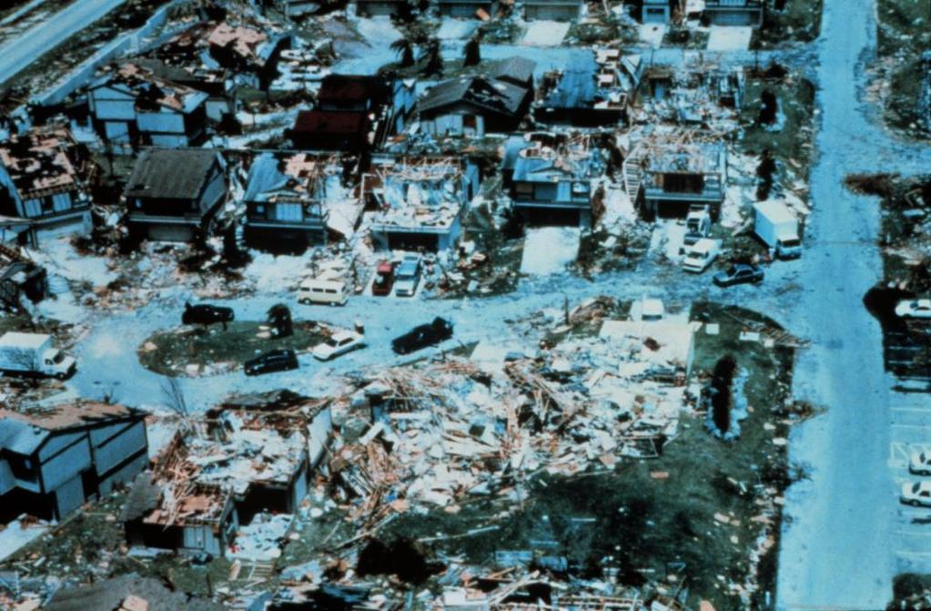
16 AFTER THE STORM After the Storm Call your supervisor and subordinates and let them know of your status Keep listening to radio, TV or NOAA Weather Radio All Hazards. Wait until an area is declared safe before entering. Watch for closed roads. If you come upon a barricade or a flooded road, TURN AROUND Stay on firm, dry ground. Moving water only 6 inches deep can sweep you off your feet (it can take less than an inch to drown if unconscious) If using a generator, avoid carbon monoxide poisoning by following the manufacturer s instructions. Avoid weakened bridges and washed out roads. Once home, check gas, water and electrical and appliances for damage/leaks. Use a flashlight to inspect damage. Never use candles and other open flames indoors. Wear proper shoes to prevent cutting feet on sharp debris. Do not drink or prepare food with tap water until officials say it is safe. Avoid electrocution by not walking in areas with downed power lines. BEFORE AFTER

17 After the Storm More people get injured and die after the storm than during the storm Flood related hazards Wreckage related hazards Downed power-lines They can be hidden under water and debris
18 Hurricane Terminology STORM NOTIFICATIONS Storm and hurricane forecasts and warnings are issued by NOAA s Advisory: Weather advisory messages are issued for tropical storms and hurricanes. An advisory states the location, intensity, direction of travel, and speed of a tropical storm or hurricane. Tropical Strom Watch: An announcement that tropical storm conditions (sustained winds of 39 to 73 mph) are possible within the specified coastal area within 48 hours Tropical Storm Warning: An announcement that tropical storm conditions (sustained winds of 39 to 73 mph) are expected somewhere within the specified coastal area within 36 hours. Storm Warning: A warning of winds within the range of mph (48-63 knots) either predicted or occurring, and not directly associated with a tropical cyclone. Hurricane Watch: An announcement that hurricane conditions (sustained winds of 74 mph or higher) are possible somewhere within the specified coastal area. Because hurricane preparedness activities become difficult once winds reach tropical storm force, the hurricane watch is issued 48 hours in advance of the anticipated onset of tropical-storm-force winds. Hurricane Warning: An announcement that hurricane conditions (sustained winds of 74 mph or higher) are expected somewhere within the specified coastal area. Because hurricane preparedness activities become difficult once winds reach tropical storm force, the hurricane warning issued 36 hours in advance of the anticipated onset of tropical-storm-force winds
19 Hurricane Conditions HURCON. 5 General Hurricane Season, 1 June to 30 November 4 Indicates surface winds in excess of 58 mph (50 knots) could arrive within 96 hours. 3 Indicates surface winds in excess of 58 mph could arrive within 72 hours. Mandatory evacuation likely at this time! 2 Indicates surface winds in excess of 58 mph could arrive within 48 hours. Mandatory evacuation at this time. 1 Indicates surface winds in excess of 58 mph could arrive within 24 hours. Mandatory evacuation at this time / Installation will be closed. 1E Indicates surface winds in excess of 58 mph are occurring and other dangerous conditions associated with the storm are present. All outside activity is strictly prohibited. Installation will be closed. 1R Indicates life-threatening storm hazards have passed but damage may persist and only emergency responders and damage assessment personnel are released to move about.


20 Hurricane Hazards Storm Surge/Tide Storm surge and large waves produced by hurricanes pose the greatest threat to life and property along the coast. STORM SURGE is an abnormal rise of water generated by a storm s winds. Storm surge can reach heights well over 20 feet and can span hundreds of miles of coastline. In the northern hemisphere, the highest surge values typically occur in the right front quadrant of a hurricane coincident with onshore flow; in the southern hemisphere, the left front quadrant. More intense and larger hurricanes produce higher surge. In addition, shallower offshore waters contribute to higher storm surge inundation. Storm surge is by far the greatest threat to life and property along the immediate coast. STORM TIDE is the water level rise during a storm due to the combination of storm surge and the astronomical tide. For example, if a hurricane moves ashore at a high tide of 2 feet, a 15 foot surge would be added to the high tide, creating a storm tide of 17 feet. The combination of high winds and storm tide topped with battering waves can be deadly and cause tremendous property damage along an area of coastline hundreds of miles wide.
. The orange circle denotes the current position of the tropical cyclone.")
21 Tropical Cyclone Graphical Products Track Forecast Cone and Watches/Warning This graphic shows coastal areas under a hurricane warning (red), hurricane watch (pink), tropical storm warning (blue), and a tropical storm watch (yellow). The orange circle denotes the current position of the tropical cyclone. The black dots indicate the forecast positions and cyclone classification over the next 5 days. Track Forecast Cone and Watches/Warnings Forecast errors and uncertainty of the future tropical cyclone center location are accounted for by the track forecast cone. The solid white area denotes the uncertainty for days 1-3. The white stippled area shows the uncertainty for days 4 and 5. On average, the center of the tropical cyclone will remain inside the cone 60% 70% of the time. It is important to remember that a tropical cyclone is not a point and that the associated hazards can extend well outside of the track forecast cone.

22 Tropical Cyclone Graphical Products Graphical Tropical Weather Outlook This graphic highlights areas of disturbed weather in the tropics and subtropics and assesses the potential for these systems to become tropical cyclones over the next 48 hours. Each disturbance is circled and numbered with an accompanying text description. You also can view the text description by moving your mouse over the circled area. The color of the circles reflect the probability that the system will become a tropical cyclone over the next 48 hours: Yellow: low chance, <30% Orange: medium chance, 30% 50% Red: high chance, >50% Active tropical cyclones are depicted on the graphic as an L for tropical depressions, a tropical storm symbol, or a hurricane symbol. Graphical Tropical Weather Outlook
 sustained winds.")
23 Tropical Cyclone Graphical Products Tropical Cyclone Surface Wind Speed Probabilities This graphic indicates the chance of locations experiencing at least tropical storm (39 mph or greater) sustained winds over the following 5 days. The graphic is also available at thresholds of 58 mph and 74 mph (hurricane force) sustained winds. The product is unique in that it takes into account uncertainty in the track, peak winds and size of the storm. This graphic also highlights the fact that tropical cyclone winds can extend well away from the storm s center. It is important to realize that probabilities that seem relatively low may still be quite significant. For example, if a location has a 10% chance of experiencing hurricane force sustained winds, you should prepare for an extreme event. A 1 in 10 chance is too high to ignore. Tropical Cyclone Surface Wind Speed Probabilities
 Have a battery powered commercial radio Pack non-perishables and")

415-7824 DSN: (312)535-7824 482ces.")
24 Choose an evacuation site Are You Ready? Assemble a supply kit ( Have a battery powered commercial radio Pack non-perishables and drinking water Plastic for doors, windows and vents for chosen room if evacuation is not possible First aid kit Sanitation supplies including soap, water and bleach For More information Contact us at: 482 MSG/CEX Westover St Homestead ARB, FL Commercial: (786) DSN: (312) ces.em@us.af.mil
Where Do Hurricanes Occur?
 Where Do Hurricanes Occur? How Often Do Hurricanes Hit the U.S.? Hurricane Return Periods Hurricane return periods are the frequency at which a certain intensity of hurricane can be expected within a
FEMA Hurricane Fact Sheet
 PIA Doc. No. 90191 FEMA Hurricane Fact Sheet The information contained within this Resource kit is provided by the Federal Emergency Management Agency and is provided as a PIA member service. To contact
St. Pete Beach enews. The Official Electronic Newsletter of St. Pete Beach. June 9, 2016
 St. Pete Beach enews The Official Electronic Newsletter of St. Pete Beach June 9, 2016 POOL INFORMATION Water temp. always 82! POOL HOURS May 15th August 7th Adult Lap Swim Mon-Fri: 7a-10a Mon-Thu: 11a-4p
Marc Ferguson Calcasieu Parish Office of Homeland Security & Emergency Preparedness
 HURRICANE PREPAREDNESS Marc Ferguson Calcasieu Parish Office of Homeland Security & Emergency Preparedness 2015 Colorado Terms To Know State University Hurricane Outlook Tropical Depression Tropical Storm
Tropical Cyclones. A PREPAREDNESS GUIDE U.S. DEPARTMENT OF COMMERCE National Oceanic and Atmospheric Administration National Weather Service
 Tropical Cyclones Hurricane Earl, September 1, 2010/NOAA A PREPAREDNESS GUIDE U.S. DEPARTMENT OF COMMERCE National Oceanic and Atmospheric Administration National Weather Service Revised March 2012 What
HURRICANE PREPAREDNESS GUIDE
 HURRICANE PREPAREDNESS GUIDE BE PREPARED! TABLE OF CONTENTS Basic Preparedness Tips... 3 Preparing Your Home... 4 What To Do... 5 Make a Hurricane Plan... 6 Important Information... 7 pacu.com 800.433.7228
Hurricanes ARE YOU READY? 33 FEDERAL EMERGENCY MANAGEMENT AGENCY
 ARE YOU READY? 33 Hurricanes A hurricane is a type of tropical cyclone, the generic term for a low pressure system that generally forms in the tropics. The ingredients for a hurricane include a pre-existing
Identify levees and dams in your area and determine whether they pose a hazard to you.
 Courtesy of The Insurance Exchange Hurricanes are capable of producing winds in excess of 155 miles per hour and causing catastrophic damage to coastlines and several hundred miles inland. Additionally,
New Pig Corporation newpig.com HOT-HOGS Page 1 of 10
 Develop a Disaster Preparedness Plan Assess your risks of natural and manmade disasters Purchase adequate insurance and ensure that you have the types of coverage you may need Keep employee contact information
The FirstService Residential Hurricane Guide
 HURRICANE GUIDE Hurricane Season runs June 1 through November 30, bringing the possibility of strong and potentially damaging winds and storm surges to the hurricane-prone east and Gulf coasts. If you
Key Takeaways: - Rain: Coastal NC: ; isolated totals to 40 Central, Western, & Northeastern NC: 5-10 ; isolated totals to 20
 Key Takeaways: - Life-Threatening Impacts Will Extend Far From The Storm s Center: Despite the southward shift in track, widespread and extreme impacts from heavy rain, storm surge, and wind are still
HURRICANE PREPAREDNESS PLAN PROTECT YOUR CAST AND CREW & LOWER THE COST OF HURRICANE PRODUCTION INSURANCE
 HURRICANE PREPAREDNESS PLAN PROTECT YOUR CAST AND CREW & LOWER THE COST OF HURRICANE PRODUCTION INSURANCE Our office is regularly asked if the cost of production insurance during hurricane season can be
COLORING & ACTIVITY BOOK
 COLORING & ACTIVITY BOOK Here are some important tips for hurricane season. Broward County wants you and your family to be during hurricane season June 1st through November 30th. Let s get started! 2 Hurricane
Hurricane Preparedness
 Hurricane Preparedness Hurricanes can be dangerous killers. A hurricane is a tropical storm with winds that have reached a constant speed of 74 mph or more. Hurricane winds blow in a large spiral around
Asia. Africa. Antarctica. Europe. North America. AdventureHomeschool.com. South America. Australia
 North America Europe Asia Africa South America Australia Antarctica AdventureHomeschool.com Use the map on the 1 st page to determine the answers Storms that are 75 200 mph which form in the Atlantic Ocean
HURRICANE PREPAREDNESS PLAN
 Florida Film, Television, and Entertainment HURRICANE PREPAREDNESS PLAN PROTECT YOUR CAST AND CREW & LOWER THE COST OF HURRICANE PRODUCTION INSURANCE Our office is regularly asked if the cost of production
Hurricane Preparedness and Awareness!
 Hurricane Preparedness and Awareness! Check these out Time to begin executing the evacuation plan What kind of damage are we talking about here? What Exactly Is a Hurricane? A hurricane can best be described
Hurricane Awareness 2017
 Hurricane Awareness 2017 Hurricane Isabel from the International Space Station NASCC Emergency Management Department When will a Hurricane hit Corpus Christi? Port Lavaca Rockport Corpus Christi Kingsville
Marine Corps Base. Disaster Preparedness Activity Book
 Marine Corps Base Disaster Preparedness Activity Book Dear Parents and Educators News stories of disaster regularly make headlines around the globe. As you ve watched others deal with these emergencies,
Safety Issue: Types of weather emergencies and natural. Weather Emergencies
 Overview Safety Issue: Rapid and effective response to weather emergencies and other natural disasters whether during or after work hours takes forethought and careful planning. Types of weather emergencies
Typhoon Preparation Tips
 Typhoon Preparation Tips The Pacific Ocean can generate some of the most intense storms in the world, and Guam s location makes it a target for typhoons. Here are some ways you can make yourself typhoon-ready.
2015 Plymouth Rock Assurance New Jersey Hurricane Preparedness Study
 2015 Plymouth Rock Assurance New Jersey Hurricane Preparedness Study About This Study Tropical storms and hurricanes directly and indirectly impact New Jersey and its 130 miles of Atlantic coastline. Although
Tornado. Extreme Heat. Flooding. Fire. Thunderstorm. Hazardous Materials. Blizzard
 Tornado Extreme Heat Fire Flooding Thunderstorm Hazardous Materials Blizzard Where do you think you two are going? A Tornado Watch has been issued until 7 pm. Hey, let s go out and play! Every house should
Hurricanes and coastal storms pose a risk because powerful winds and storm surges can:
 HURRICANES A hurricane is a violent area of low pressure forming in the tropical Atlantic Ocean from June to November. August and September are peak months. (Similar Western Pacific Ocean storms are called
Hurricanes. Environmental Geology Mr. Paul Lowrey. Stacey Singleton, Cassandra Combs, Dwight Stephenson, Matt Smithyman
 Environmental Geology Mr. Paul Lowrey Stacey Singleton, Cassandra Combs, Dwight Stephenson, Matt Smithyman Hurricanes EMPACTS Project, Spring 2017 Northwest Arkansas Community College, Bentonville, AR
TORNADO PREPAREDNESS AND INFORMATION MANUAL
 TORNADO PREPAREDNESS AND INFORMATION MANUAL What is a Tornado? A tornado is defined as a violently rotating column of air extending from a thunderstorm to the ground. The most violent tornadoes are capable
BROWARD COLLEGE HURRICANE SAFETY ACTION GUIDE 2018
 BROWARD COLLEGE HURRICANE SAFETY ACTION GUIDE BROWARD COLLEGE HURRICANE SAFETY ACTION GUIDE 2018 1 P age 2018 QUICK REFERENCE HURRICANE GUIDE TABLE OF CONTENTS 2018 BROWARD COLLEGE HURRICANE SAFETY ACTION
READY WRIGLEY PREPARES FOR HURRICANES
 READY WRIGLEY PREPARES FOR HURRICANES NAME: Note to Parents, Guardians, and Teachers The Centers for Disease Control and Prevention has created Ready Wrigley to provide parents, guardians, teachers, and
Altus AFB Emergency Management. Emergency Preparedness. Building a Disaster Supply Kit
 Emergency Communication Plan When a disaster strikes, there is a chance that your family is not together. It is important to think about some of the following situations and make a plan just in case. Here
Emergency Management: A Guide for Personal & Family Preparedness. COMFLEACT Yokosuka Emergency Management Office
 Emergency Management: A Guide for Personal & Family Preparedness COMFLEACT Yokosuka Emergency Management Office Computer Desktop Notification System (CDNS) GET NOTIFIED!!! Computer Desktop Notification
HURRICANE SURVIVAL KIT
 HURRICANE SURVIVAL KIT DEFINITION-A hurricane is a very vast and powerful storm that originates in the tropics of the Atlantic Ocean. They become hurricanes when the sustained winds associated with it
City of Punta Gorda Community Emergency Management Plan 2013
 City of Punta Gorda Community Emergency Management Plan 2013 Hurricane Andrew- August 24, 1992 Category 5 hurricane. The second-most-destructive hurricane in U.S. history. The first named storm of the
Hurricane Guide 2016
 Hurricane Guide 2016 2015 was a very active year for natural disasters in the State of Texas. The Memorial Day Floods on the Blanco River and in Houston were some of the most devastating flooding in the
Hurricane Matthew Threats and Impacts Briefing for Eastern NC
 Hurricane Matthew Threats and Impacts Briefing for Eastern NC October 6 th, 2016 Date/Time Created: 10/6/2016, Noon EDT National Weather Service Newport/Morehead City, NC Hurricane Matthew Key Points Changes
Hurricanes and Coastal Storms
 Hurricanes and Coastal Storms Hurricanes and Coastal Storms Display Slide Hu-0 What is the difference between a hurricane and a coastal storm? Allow the participants time to respond before displaying the
TORNADO SAFETY From the Michigan Committee on Severe Weather Awareness
 Tornado Terminology Tornadoes can happen abruptly, especially during Michigan s late spring and early summer seasons. Learn the terms to understand and know what do before, during and after a tornado.
2013 Tornado and Severe Weather Awareness Drill
 2013 Tornado and Severe Weather Awareness Drill Scheduled for Thursday April 18, 2013 The 2013 Tornado Drill will consist of a mock tornado watch and a mock tornado warning for all of Wisconsin. This is
Catastrophic: Most buildings destroyed. Vegetation destroyed. Major roads cut off. Homes flooded.
 HURRICANE PREPAREDNESS INFORMATION PROVIDED BY THE GULF COAST CENTER 2007 HURRICANE SEASON Hurricane A hurricane is a type of tropical cyclone, the generic term for a low pressure system that generally
While all thunderstorms are dangerous, the National Weather Service (NWS) defines a severe thunderstorm as one that:
 defines a severe thunderstorm as one that:") While all thunderstorms are dangerous, the National Weather Service (NWS) defines a severe thunderstorm as one that: Produces hail at least three-quarters of an inch in diameter. Has winds of 58 miles
While all thunderstorms are dangerous, the National Weather Service (NWS) defines a severe thunderstorm as one that: Produces hail at least three-quarters of an inch in diameter. Has winds of 58 miles
HURRICANE PREPAREDNESS. Information and Preparedness Guide for Students
 HURRICANE PREPAREDNESS Information and Preparedness Guide for Students Students at the Medical University of South Carolina are encouraged to use the following guide to prepare for hurricane season. It
2017 GUIDE TO Hurricane Readiness
 2017 GUIDE TO Hurricane Readiness Hurricane Season June 1 November 30 Table of Contents Gather Information...2 Make a Plan...3 Prepare Your Home...4 Evacuate or Stay at Home?...5 Resources...6 CALL NOW
 STATE OF WISCONSIN/ DEPARTMENT OF MILITARY AFFAIRS WISCONSIN EMERGENCY MANAGEMENT 2400 WRIGHT STREET P.O. BOX 7865 MADISON, WISCONSIN 53707-7865 608-242-3232 February 22, 2007 Re: Tornado and Severe Weather
Risk Assessment and Mitigation. Hurricane Checklist
 Risk Assessment and Mitigation Hurricane Checklist Hurricane Checklist Hurricanes are severe tropical storms with sustained winds of at least 74 miles per hour. Hurricane winds can reach 160 miles per
City of Tarpon Springs Emergency Management. Hurricane Season 2017
 City of Tarpon Springs Emergency Management Hurricane Season 2017 September 1, 2016- We came close Hurricane Hermine First Hurricane to make landfall in Florida since 2005 Are you Ready? Prepare your Home
COMMUNITY EMERGENCY RESPONSE TEAM FLOODS INTRODUCTION
 INTRODUCTION Floods are one of the most common hazards in the United States. A flood occurs any time a body of water rises to cover what is usually dry land. Flood effects can be local, impacting a neighborhood
COMMUNITY EMERGENCY RESPONSE TEAM TORNADOES
 Tornadoes are powerful, circular windstorms that may be accompanied by winds in excess of 200 miles per hour. Tornadoes typically develop during severe thunderstorms and may range in width from several
Tornadoes pose a high risk because the low atmospheric pressure, combined with high wind velocity, can:
 Tornadoes are powerful, circular windstorms that may be accompanied by winds in excess of 200 miles per hour. Tornadoes typically develop during severe thunderstorms and may range in width from several
LOS ANGELES UNIFIED SCHOOL DISTRICT REFERENCE GUIDE
 TITLE: NUMBER: ISSUER: School Procedures During Inclement Weather Conditions REF-5706.2 Earl R. Perkins, Assistant Superintendent School Operations Thelma Meléndez de Santa Ana, Ph.D. Chief Executive Officer
Key to the Emergency. Preparedness Prince. Preparedness. Princess. Pre-K - 2nd Grade
 Key to the Emergency Preparedness Castle Preparedness Prince & Preparedness Princess Pre-K - 2nd Grade PREPAREDNESS PRINCE & Preparedness Princess HERE TO TEACH YOU ALL ABOUT EMERGENCY PREPAREDNESS The
Policy and Procedure for Emergency Planning
 Viera Children s Academy 3395 Viera Boulevard Viera, Florida 32940 (321) 4332330 (321) 4332331 fax Policy and Procedure for Emergency Planning Director Signature Date Purpose: To ensure that in the event
Hurricane Preparedness
 TAKING THE WIND OUT OF HURRICANE DAMAGE National Oceanic and Atmospheric Administration is predicting another near or above average season in 2018, expecting up to 16 storms and nine hurricanes, several
Frank Revitte National Weather Service. Weather Forecast Office New Orleans/Baton Rouge
 Frank Revitte National Weather Service Weather Forecast Office New Orleans/Baton Rouge Above normal activity 17 Total Named Storms 7 Tropical Storms 4 Hurricanes 6 Major Hurricanes Not the most active,
TORNADOES. DISPLAY VISUAL A Tornado Is... Tornadoes can: Rip trees apart. Destroy buildings. Uproot structures and objects.
 TORNADOES Introduce tornadoes by explaining what a tornado is. DISPLAY VISUAL A Tornado Is... A powerful, circular windstorm that may be accompanied by winds in excess of 250 miles per hour. Tell the participants
3 Severe Weather. Critical Thinking
 CHAPTER 2 3 Severe Weather SECTION Understanding Weather BEFORE YOU READ After you read this section, you should be able to answer these questions: What are some types of severe weather? How can you stay
Tornado Preparedness. Monthly Safety Meeting
 Tornado Preparedness Monthly Safety Meeting Introduction Tornadoes can occur anywhere and at any time during the year. In an average year, 800 tornadoes are reported throughout the nation. The most violent
**Copies of this hurricane manual are available in the Lake Emerald office** (Lake Emerald Owner s Association, Inc.)
") **Copies of this hurricane manual are available in the Lake Emerald office** (Lake Emerald Owner s Association, Inc.) HURRICANE PROCEDURES 2013 Dear Residents, Hurricane season begins June 1 and ends on
**Copies of this hurricane manual are available in the Lake Emerald office** (Lake Emerald Owner s Association, Inc.) HURRICANE PROCEDURES 2013 Dear Residents, Hurricane season begins June 1 and ends on
Severe Weather Hazards Are Real
 Severe Weather Hazards Are Real In the past 10 years, more than 40 people have died and dozens more injured as a result of weatherrelated events in Minnesota (not including motor vehicles.) The top severe
Disaster Timeline Messages
 Disaster Timeline Messages Each disaster is unique and messaging should reflect the specific circumstances of the incident. The grid below can help guide key messages before, during and after disasters.
UNIVERSITY OF WISCONSIN-PARKSIDE TORNADO WARNINGS AND ALERT POLICY ADMINISTRATIVE POLICY NUMBER 39 TABLE OF CONTENTS
 UNIVERSITY OF WISCONSIN-PARKSIDE TORNADO WARNINGS AND ALERT POLICY ADMINISTRATIVE POLICY NUMBER 39 TABLE OF CONTENTS Page 1. PURPOSE 2 2. DEFINITIONS 2 3. GENERAL OVERVIEW 2 4. SPECIFIC PROCEDURES 3 4.1
State Of Wisconsin Department of Military Affairs
 State Of Wisconsin Department of Military Affairs Division of Emergency Management Brian M. Satula Administrator Scott Walker Governor For more information contact: Tod Pritchard Office: 608-242-3324 Cell:
Chancellor s Memorandum CM-64 Tornado Policy
 Chancellor s Memorandum CM-64 Tornado Policy To: Vice Chancellors, Deans, Administrative Staff, and Department Heads. From: LSU Health Sciences Center New Orleans Chancellor July 11, 2017 Revised on September
Inclement Weather Preparedness. Tornadoes and Severe Thunderstorms
 Inclement Weather Preparedness Tornadoes and Severe Thunderstorms Let s find out How do we prepare ahead of time? What is the difference between a watch and a warning? What are the severe weather communications
HURRICANE PROCEDURES For Lagoon Landing
 HURRICANE PROCEDURES For Lagoon Landing The President or his/her designee will issue all necessary directives and instructions concerning the implementation of these procedures and the resumption of classes.
TORNADO/high winds *
 TORNADO/high winds * WATCH Bring people inside. Secure outside objects. Clear window ledges & wall hangings Close drapes Protect windows Assemble and check supplies Call in applicable staff Pre-Storm:
Hurricane Basics and Preparedness. Jim Weyman Director, Central Pacific Hurricane Center Phone Office:
 Hurricane Basics and Preparedness Jim Weyman Director, Central Pacific Hurricane Center Phone Office: 973-5270 james.weyman@noaa.gov United States Hurricane/Typhoon Centers National Hurricane Center, Miami
Tornadoes. Tornadoes COMMUNITY EMERGENCY RESPONSE TEAM TORNADOES
 Tornadoes Tornadoes Tell the participants that tornadoes are powerful, circular windstorms that may be accompanied by winds in excess of 200 miles per hour. Tornadoes typically develop during severe thunderstorms
0 1 8 STORM SEASON GUIDE
 2 0 1 8 STORM SEASON GUIDE HURRICANE PREPAREDNESS 101 When it comes to hurricanes, there s no such thing as being too prepared. The key to weathering any storm is to have the right tools. This includes
Preparedness Safety Tips
 Preparedness Safety Tips Timely preparation can avert heavy personal, business and government expenditures. Experts agree that the following measures can be effective in dealing with the challenges of
Hurricane Preparedness
 Hurricane Preparedness The official Hurricane Season runs from June 1st until November 30th. Today, the National Hurricane Center is able to predict severe weather patterns with sufficient time for us
CHI! CHIRRPA! CHA! CHIRPA! CHI! CHI! GETTING READY FOR HURRICANE SEASON?
 CHIRPA! GETTING READY FOR HURRICANE SEASON? WHAT IS A HURRICANE?A hurricane is a large tropical weather system with winds of 74 mph or faster that rotate around the center of the storm. A hurricane forms
Annex B Natural No-Notice Event
 Annex B Natural No-Notice Event Version: 1.0 Effective: 10/01/2015 Revision Date: 10/01/2015 Approved By: John Pitcher Purpose The purpose of Natural No-Notice Event Annex is to ensure the safety of BHCC
Common Core Reading Passage
 Directions: Please read the following Common Core Reading passage and answer the questions that follow. Common Core Reading Passage Forecasting Severe Weather to Communities Helps Them Prepare By Alissa
2017 Hurricane Season and Beyond
 2017 Hurricane Season and Beyond Ken Graham National Hurricane Center Building a Weather-Ready Nation Much of U.S. Coast Saw Tropical Wind Watches or Warnings 2017 Hurricane Season Facts and Figures 7th
UNIVERSITY OF SOUTH FLORIDA SYSTEM HURRICANE GUIDE
 UNIVERSITY OF SOUTH FLORIDA SYSTEM HURRICANE GUIDE usf.edu/em Important Sources of Information All official information regarding campus closings, class cancellation, evacuation, and re-population for
Are You Ready For Hurricane Season? 2018 Hurricane Talk B Y : S T O R M T E A M 8 M E T E O R O L O G I S T J U L I E P H I L L I P S
 Are You Ready For Hurricane Season? 2018 Hurricane Talk B Y : S T O R M T E A M 8 M E T E O R O L O G I S T J U L I E P H I L L I P S About Me I am Currently a Weekday Meteorologist at WFLA Channel 8.
Compare and Contrast
 Read the two passages about hurricanes. Think about similarities and differences between the two passages. How and Where Hurricanes Form Hurricanes are very powerful storms that are capable of causing
Floods. Floods COMMUNITY EMERGENCY RESPONSE TEAM FLOODS CONTENT INSTRUCTOR GUIDANCE
 Floods Floods Introduce this topic by explaining that floods are one of the most common hazards in the United States. A flood occurs any time a body of water rises to cover what is usually dry land. Display
How Power is Restored After a Severe Storm. Presented by Stacy Shaw, Safety Director & Nolan Hartzler, GIS Mapping Technician
 How Power is Restored After a Severe Storm Presented by Stacy Shaw, Safety Director & Nolan Hartzler, GIS Mapping Technician Hurricanes, ice storms, tornadoes One inch of ice on a single span of electric
IN VEHICLES: Do not try to outrun a tornado. Abandon your vehicle and hide in a nearby ditch or depression and cover your head.
 TORNADO SAFETY TORNADO! The very word strikes fear in many people. While a tornado is perhaps nature's most destructive storm, deaths and injuries can be prevented. By following Tornado Safety Rules, lives
Are you prepared? HURRICANE GUIDE UNIVERSITY OF SOUTH FLORIDA SYSTEM. The 2017 Hurricane Season was one of the worst in history
 Are you prepared? UNIVERSITY OF SOUTH FLORIDA SYSTEM HURRICANE GUIDE usf.edu/em The 2017 Hurricane Season was one of the worst in history 10 named storms Hundreds of fatalities Over $282 billion in damage
State Of Wisconsin. Department of Military Affairs. Division of Emergency Management
 State Of Wisconsin Department of Military Affairs Division of Emergency Management Brian M. Satula Administrator Scott Walker Governor For more information contact: Tod Pritchard Office: 608-242-3324 Cell:
Tornado. damage. thunderstorms and can cause a lot of. Tornadoes usually happen during. reaches from the sky to the ground.
 A strong rotating tunnel of air that reaches from the sky to the ground. Tornadoes usually happen during thunderstorms and can cause a lot of damage. Identify and prepare a wind safe room. or shelter (basement/cellar
Severe Thunderstorms
 Severe Thunderstorms Severe Thunderstorms Explain that, while all thunderstorms are dangerous, the National Weather Service (NWS) defines a severe thunderstorm as one that: Display Slide Th-0 Produces
Hurricanes. Check The Weather Channel Education online glossary (http://www.weatherclassroom.com) for the meanings of these weather terms.
 for the meanings of these weather terms.") Age Range: This unit has been designed specifically for students in grades 5-8. It can easily be adapted for younger or older students. Teaching Note: Depending on your time frame and student abilities
Age Range: This unit has been designed specifically for students in grades 5-8. It can easily be adapted for younger or older students. Teaching Note: Depending on your time frame and student abilities
PLANNING FOR HURRICANE AND TROPICAL STORMS FOR THE DIOCESE OF CORPUS CHRISTI
 PLANNING FOR HURRICANE AND TROPICAL STORMS FOR THE DIOCESE OF CORPUS CHRISTI SECTION ONE Hurricanes and Tropical Storms SECTION KEY Disaster Definitions Planning for a Hurricane Levels of Activation Checklists
Major Hurricane Matthew Briefing Situation Overview
 Major Hurricane Matthew Briefing Situation Overview THIS IS NOW A WORST CASE STORM SURGE SCENARIO Catastrophic Damage is Anticipated for Coastal Areas. Major Hurricane Matthew is still expected to move
GC Briefing. Weather Sentinel Hurricane Florence. Status at 5 PM EDT (21 UTC) Today (NHC) Discussion. September 13, 2018
 Today (NHC) Discussion. September 13, 2018") GC Briefing September 13, 2018 Weather Sentinel Hurricane Florence Tropical storm conditions have been reported for areas of North Carolina and will continue to spread inland to the west and south. Hurricane
GC Briefing September 13, 2018 Weather Sentinel Hurricane Florence Tropical storm conditions have been reported for areas of North Carolina and will continue to spread inland to the west and south. Hurricane
Guided Notes Weather. Part 2: Meteorology Air Masses Fronts Weather Maps Storms Storm Preparation
 Guided Notes Weather Part 2: Meteorology Air Masses Fronts Weather Maps Storms Storm Preparation The map below shows North America and its surrounding bodies of water. Country borders are shown. On the
SEVERE WEATHER EMERGENCY RESPONSE PROCEDURE
 SEVERE WEATHER EMERGENCY RESPONSE PROCEDURE SEVERE WEATHER EMERGENCY RESPONSE PROCEDURE ALGORITHM Staff Member becomes aware of Severe Weather Assess Threat Imminent Tornado Strike NO Notify Supervisor
EMERGENCY PREPAREDNESS PLAN
 EMERGENCY PREPAREDNESS PLAN CONTENTS OVERVIEW WILDFIRE EARTHQUAKE HURRICANE FLOOD TORNADO 2 3 5 7 8 10 BE PREPARED. OVERVIEW No matter the type of weather emergency, you should make a family communication
The Wind Hazard: Messaging the Wind Threat & Corresponding Potential Impacts
 The Wind Hazard: Messaging the Wind Threat & Corresponding Potential Impacts Scott Spratt Warning Coordination Meteorologist NWS Melbourne, FL David Sharp Science & Operations Officer NWS Melbourne, FL
Protecting Your Business This Winter Weather Season
 Protecting Your Business This Winter Weather Season Fred Schmude, StormWatch Manager, ImpactWeather Mark Norton, Senior Continuity Manager, Agility Recovery Today s session will be recorded. Links to the
ready get QUEENSLAND PREPARE YOUR EMERGENCY PLAN OUR LOCAL EMERGENCY CONTACTS
 STORM CYCLONE TSUNAMI FLOOD PREPARE YOUR EMERGENCY PLAN get ready QUEENSLAND www.qld.gov.au/getready Don t wait for a disaster to happen before you think about how you and your family are going to survive
Welcome to our Emergency Preparedness Activity Book!
 Welcome to our Emergency Preparedness Activity Book! Having children understand the importance of emergency preparedness and coping with emergencies is a key element of emergency preparedness for families.
GC Briefing. Weather Sentinel Tropical Storm Michael. Status at 8 AM EDT (12 UTC) Today (NHC) Discussion. October 11, 2018
 Today (NHC) Discussion. October 11, 2018") GC Briefing Weather Sentinel Tropical Storm Michael October 11, 2018 After making landfall as a high-end category-4 hurricane on the Florida Panhandle, Michael weakened to tropical storm status early this
GC Briefing Weather Sentinel Tropical Storm Michael October 11, 2018 After making landfall as a high-end category-4 hurricane on the Florida Panhandle, Michael weakened to tropical storm status early this
TOWN OF ST. JAMES Residential Emergency Information/Critical Communication Links Emergency Preparation and Survival Guide February 2018
 TOWN OF ST. JAMES Residential Emergency Information/Critical Communication Links Emergency Preparation and Survival Guide February 2018 The Emergency Management (EM) Team is part of the volunteer staff
Tropical Update. 12 PM EDT Friday, October 7, 2016 Hurricane Matthew & Tropical Storm Nicole
 Tropical Update 12 PM EDT Friday, October 7, 2016 Hurricane Matthew & Tropical Storm Nicole This update is intended for government and emergency response officials, and is provided for informational and
UH Severe Weather Response Planning Kit
 UH Public Safety Department Office: (713) 743-1635 Fire Marshal s Office FAX: (713) 743-5169 UH Severe Weather Response Planning Kit This UH Severe Weather Response Planning Kit contains the following
Hurricane Season 2010 & NOAA s Deepwater Response
 Hurricane Season 2010 & NOAA s Deepwater Response What s Happened? What Will 2010 Bring? Possible Shoreline Effects Darin Figurskey Meteorologist-in-Charge NOAA s NWS Raleigh, NC NOAA s National Weather