Radar rain gauges new alternative for urban measurement networks. Copyright OTT Hydromet 2018
|
|
|
- Shannon Bond
- 5 years ago
- Views:
Transcription


1 Radar rain gauges new alternative for urban measurement networks

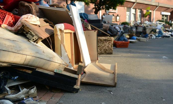
2 Stormwater event in the city of Münster July 28 th Ernst Mennerich
3 Stormwater event in the city of Münster July 28 th Ernst Mennerich

4 6 Di.,

5 City of Wuppertal 28. July Di., Foto: Privat

6 City of Wuppertal 28. July

7 City of Wuppertal 28. July Mo., Foto: Matthias Ahlke

8 City of Wuppertal 28. July

9 Micro retention! 11 Di., Foto: mfk
10 12
11 Stormwater event in the city of Münster July 28 th 2014 ~150 mm/12hrs ~292 mm Online-Calibration 13

12 Stormwater event in the city of Münster July 28 th ,53 mm within 8 hrs Pluvio² L 14
13 Stormwater event in the city of Münster July 28 th 2014 ~150 mm/12hrs 292,53 mm Online-Calibration Offline-Calibration 15


14 Overview of Different Measurement Principles Tipping Bucket Weighing Gauge Radar Disdrometer 16 Confidential and Proprietary


15 Tipping bucket Pro s: Con s: Standard in many applications Low price Medium accuracy High Maintenance required!!! Lower accuracy in low and high ranges Even more inaccurate during winter operation 17
 Most accurate measurement of liquid")


16 OTT Pluvio² - Weighing system Pro s Con s No moving parts Low maintenance (1 2 per year) Most accurate measurement of liquid and solid precipitation due to weighing principle Proven in WMO intercomparison test 15,000 units deployed in countries of Northern Hemisphere Higher investment necessary Sometimes form factor Pluvio² L Bucket 1500 mm Highly accurate weighing system 18

17 OTT Parsivel² - Laser-based optical system Laser-based optical system Parsivel² for simultaneous measurement of Particle Size and Velocity in precipitation The sensor's transmitter unit generates a flat, horizontal beam of light, which the receiver unit converts into an electric signal. This signal changes whenever a particle falls through the beam anywhere within the measurement area The degree of dimming is a measure of the particles size, and together with duration of the signal, the fall velocity can be derived. 19


18 OTT Parsivel² - Laser-based optical system Drop Spectrum 20


19 OTT Parsivel² Weather Radar Drop size distribution data Radar reflectivity Z/R Real-time Disdrometer solution 21
20 OTT Parsivel² - Laser-based optical system Pro s Con s Not only intensity, but type of precipitation High accuracy (type of precipitation) Delivers parameter for weather radar optimization Less accurate than a Pluvio (intensity of precipitation) Parsivel² 22

21 New Precipitation sensor WS100 WS100 24GHz Doppler Radar precipitation sensor with disdrometer functionality 23


22 Overview - WS100-UMB Measuring Principle 24 GHz Microwave Doppler Radar works with the radar reflection method and measures the precipitation quantity or precipitation intensity by means of the correlation of drop size and velocity. Drop Size distribution matrix to calculate intensity of precipitation and to determine type of precipitation according fundamental meteorological relationships Rain Snow WS100 24
 Dome heating available Cost efficient Con s: Lower Accuracy liquid: +/- 10 % Solid: +/- 30 % WS100")
23 Overview - WS100-UMB Measuring Principle Pro s: Maintenance-free operation Precipitation type detection (rain, snow, sleet, freezing rain, hail) Extremely fast measurement (first drop detected) Dome heating available Cost efficient Con s: Lower Accuracy liquid: +/- 10 % Solid: +/- 30 % WS100 28


24 When to use what? Tipping bucket if man power for maintenance is available Weighing principle if highest accuracy (intensitiy) and low maintenance is required for statistical analysis Disdrometer if type of precipitation is required for improvement of weather radars Radar if no maintenance is required if consolidation of network is required if accuracy is not so important 31

25 Thank you very much for your attention! 32
Sensor Guide WS100 Radar Precipitation Sensor
 Abbeon Cal, Inc., 1363 Donlon Street Unit 1, Ventura, CA 93003-8387 - 800-922-0977 www.abbeon.com - E-mail: abbeoncal@abbeon.com Sensor Guide WS100 Radar Precipitation Sensor October 2017 Sensor Guide:
OTT PARSIVEL - ENHANCED PRECIPITATION IDENTIFIER AND NEW GENERATION
 OTT PARSIEL - ENHANCED PRECIPITATION IDENTIFIER AND NEW GENERATION OF PRESENT WEATHER SENSOR BY OTT MESSTECHNIK, GERMANY Authors: (1) Kurt Nemeth OTT Messtechnik GmbH & Co. KG Ludwigstrasse 16 87437 Kempten
Non catchment type instruments for snowfall measurement: General considerations and
 Non catchment type instruments for snowfall measurement: General considerations and issues encountered during the WMO CIMO SPICE experiment, and derived recommendations Authors : Yves Alain Roulet (1),
THE INTERNATIONAL REVIEW OF WEATHER, CLIMATE AND HYDROLOGY TECHNOLOGIES AND SERVICES
 THE INTERNATIONAL REVIEW OF WEATHER, CLIMATE AND HYDROLOGY TECHNOLOGIES AND SERVICES Meteorological T E C H N O L O G Y I N T E R N A T I O N A L THE GREATEST SHOW YET! FULL METEOROLOGICAL TECHNOLOGY WORLD
PRECIPITATION TYPE AND RAINFALL INTENSITY FROM THE PLUDIX DISDROMETER DURING THE WASSERKUPPE CAMPAIGN
 PRECIPITATION TYPE AND RAINFALL INTENSITY FROM THE PLUDIX DISDROMETER DURING THE WASSERKUPPE CAMPAIGN Clelia Caracciolo1, Franco Prodi1,2, Leo Pio D Adderio2 and Eckhard Lanzinger4 1 University of Ferrara,
Raindrops. Precipitation Rate. Precipitation Rate. Precipitation Measurements. Methods of Precipitation Measurement. are shaped liked hamburger buns!
 Precipitation Measurements Raindrops are shaped liked hamburger buns! (Smaller drops are more spherical) Dr. Christopher M. Godfrey University of North Carolina at Asheville Methods of Precipitation Measurement
Precipitation type from the Thies disdrometer
 Precipitation type from the Thies disdrometer Hannelore I. Bloemink 1, Eckhard Lanzinger 2 1 Royal Netherlands Meteorological Institute (KNMI) Instrumentation Division P.O. Box 201, 3730 AE De Bilt, The
A FIELD STUDY TO CHARACTERISE THE MEASUREMENT OF PRECIPITATION USING DIFFERENT TYPES OF SENSOR. Judith Agnew 1 and Mike Brettle 2
 A FIELD STUDY TO CHARACTERISE THE MEASUREMENT OF PRECIPITATION USING DIFFERENT TYPES OF SENSOR Judith Agnew 1 and Mike Brettle 2 1 STFC Rutherford Appleton Laboratory, Harwell Oxford, Didcot, Oxfordshire,
Potential solution for rain erosion of wind turbine blades
 Downloaded from orbit.dtu.dk on: Jun 28, 2018 Potential solution for rain erosion of wind turbine blades Hasager, Charlotte Bay; Bech, Jakob Ilsted; Kusano, Yukihiro; Sjöholm, Mikael; Mikkelsen, Torben
Metrological requirements for a laboratory rainfall simulator. M. Colli* 1,2, M. Stagnaro 1,2, L. Lanza 1,2, P. La Barbera 1
 Metrological requirements for a laboratory rainfall simulator M. Colli* 1,2, M. Stagnaro 1,2, L. Lanza 1,2, P. La Barbera 1 Rainfall in Urban and Natural Systems 1 University of Genova, Dep. of Civil,
Remote and Autonomous Measurements of Precipitation in Antarctica
 Remote and Autonomous Measurements of Precipitation in Antarctica Mark W. Seefeldt 1 Scott D. Landolt 2 and Andrew J. Monaghan 2 1 Cooperative Institute for Research in Environmental Sciences (CIRES) University
Intercomparision of snowfall measured by weighing and tipping bucket precipitation gauges at Jumla Airport, Nepal
 Intercomparision of snowfall measured by weighing and tipping bucket precipitation gauges at Jumla Airport, Nepal Department of Hydrology and Meteorology, Nepal Ministry of Environment, Science and Technology
A TEST OF THE PRECIPITATION AMOUNT AND INTENSITY MEASUREMENTS WITH THE OTT PLUVIO
 A TEST OF THE PRECIPITATION AMOUNT AND INTENSITY MEASUREMENTS WITH THE OTT PLUVIO Wiel M.F. Wauben, Instrumental Department, Royal Netherlands Meteorological Institute (KNMI) P.O. Box 201, 3730 AE De Bilt,
WEIGHING GAUGES MEASUREMENT ERRORS AND THE DESIGN RAINFALL FOR URBAN SCALE APPLICATIONS
 WEIGHING GAUGES MEASUREMENT ERRORS AND THE DESIGN RAINFALL FOR URBAN SCALE APPLICATIONS by M. Colli (1), L.G. Lanza (1),(2) and P. La Barbera (1) (1) University of Genova, Dep. of Construction, Chemical
MTO s Road Weather Information System (RWIS)
") MTO s Road Weather Information System (RWIS) Ontario Good Roads Association Managing Winter Operations Workshop October 19, 2017 Overview of MTO s Road Weather Information Station (RWIS) RWIS for Winter
MTO s Road Weather Information System (RWIS) Ontario Good Roads Association Managing Winter Operations Workshop October 19, 2017 Overview of MTO s Road Weather Information Station (RWIS) RWIS for Winter
Quality assurance for sensors at the Deutscher Wetterdienst (DWD)
") Quality assurance for sensors at the Deutscher Wetterdienst (DWD) Quality assurance / maintenance / calibration Holger Dörschel, Dr Tilman Holfelder WMO International Conference on Automatic Weather Stations
Quality assurance for sensors at the Deutscher Wetterdienst (DWD) Quality assurance / maintenance / calibration Holger Dörschel, Dr Tilman Holfelder WMO International Conference on Automatic Weather Stations
Inter-comparison of Raingauges on Rainfall Amount and Intensity Measurements in a Tropical Environment
 Inter-comparison of Raingauges on Rainfall Amount and Intensity Measurements in a Tropical Environment CHAN Ying-wa, Yu Choi-loi and TAM Kwong-hung Hong Kong Observatory 134A Nathan Road, Tsim Sha Tsui,
Measuring solid precipitation using heated tipping bucket gauges: an overview of performance and recommendations from WMO SPICE
 Measuring solid precipitation using heated tipping bucket gauges: an overview of performance and recommendations from WMO SPICE Michael Earle 1, Kai Wong 2, Samuel Buisan 3, Rodica Nitu 2, Audrey Reverdin
REPORTS ON THE PROGRESS IN ADDRESSING THE WORK PLAN OF THE EXPERT TEAM. Standardization in instrumentation and observations
 WORLD METEOROLOGICAL ORGANIZATION COMMISSION FOR INSTRUMENTS AND METHODS OF OBSERVATION OPAG SURFACE EXPERT TEAM ON SURFACE TECHNOLOGY AND MEASUREMENT TECHNIQUES Second Session CIMO/OPAG SURFACE/ ET ST&MT
CIE4491 Lecture. How to quantify stormwater flow urban rainfall data and resolution Marie-claire ten Veldhuis
 CIE4491 Lecture. How to quantify stormwater flow urban rainfall data and resolution Marie-claire ten Veldhuis 18-9-2013 Delft University of Technology Challenge the future Coping with heavy rainfall -
Snowfall Measurement Challenges WMO SPICE Solid Precipitation Intercomparison Experiment
 WMO World Meteorological Organization Working together in weather, climate and water Snowfall Measurement Challenges WMO SPICE Solid Precipitation Intercomparison Experiment Global Cryosphere Watch Snow
Precipitation Processes. Precipitation Processes 2/24/11. Two Mechanisms that produce raindrops:
 Precipitation is any form of water that falls from a cloud and reaches the ground. How do cloud drops grow? Chapter 7 When air is saturated with respect to a flat surface it is unsaturated with respect
Windcube TM Pulsed lidar wind profiler Overview of more than 2 years of field experience J.P.Cariou, R. Parmentier, M. Boquet, L.
 Windcube TM Pulsed lidar wind profiler Overview of more than 2 years of field experience J.P.Cariou, R. Parmentier, M. Boquet, L.Sauvage 15 th Coherent Laser Radar Conference Toulouse, France 25/06/2009
WMO SPICE. World Meteorological Organization. Solid Precipitation Intercomparison Experiment - Overall results and recommendations
 WMO World Meteorological Organization Working together in weather, climate and water WMO SPICE Solid Precipitation Intercomparison Experiment - Overall results and recommendations CIMO-XVII Amsterdam,
CLOUDS, PRECIPITATION, AND WEATHER RADAR
 CHAPTER 7 CLOUDS, PRECIPITATION, AND WEATHER RADAR MULTIPLE CHOICE QUESTIONS 1. The activation temperature of most ice-forming nuclei is 0 C. a. above b. about c. well below 2. Hygroscopic nuclei water
The Hydrologic Cycle: How Do River Forecast Centers Measure the Parts?
 The Hydrologic Cycle: How Do River Forecast Centers Measure the Parts? Greg Story Meteorologist National Weather Service Fort Worth, TX Overview n Introduction What is the mission of an RFC? n The Hydrologic
Planning and Situation of the Meteorological Observation in The Republic of Korea
 Republic of Korea JMA/WMO Workshop on Quality Management in Surface, Climate and Upper-air Observations in RA II (Asia) Tokyo, Japan 27-30 July 2010 Doc. Country (.VII.2010) Planning and Situation of the
+SOI Neutral SOI -SOI. Melt+ Melt- Melt+ Melt- Melt+ Melt- +SAM 1 (0.76) 6 (3.02) 1 (1.13) 5 (4.92) 1 (2.27) 0 (1.89) 14
 6 (3.02) 1 (1.13) 5 (4.92) 1 (2.27) 0 (1.89) 14") Supplementary Table 1. Contingency table tallying the respective counts of positive and negative surface melt index anomalies in the Ross sector as a function of the signs of the Southern Annular Mode
Supplementary Table 1. Contingency table tallying the respective counts of positive and negative surface melt index anomalies in the Ross sector as a function of the signs of the Southern Annular Mode
Meteorology. I. The Atmosphere - the thin envelope of gas that surrounds the earth.
 Meteorology I. The Atmosphere - the thin envelope of gas that surrounds the earth. A. Atmospheric Structure - the atmosphere is divided into five distinct layers that are based on their unique characteristics.
Comparative analysis of data collected by installed automated meteorological stations and manual data in Central Asia.
 Comparative analysis of data collected by installed automated meteorological stations and manual data in Central Asia. Merkushkin Aleksandr Uzhydromet 71 K. Makhsumov str., 100052 Tashkent, Uzbekistan
2.6 HOW MUCH RAIN REACHES THE SURFACE? LESSONS LEARNED FROM VERY HIGH RESOLUTION OBSERVATIONS IN THE GOODWIN CREEK WATERSHED
 2.6 HOW MUCH RAIN REACHES THE SURFACE? LESSONS LEARNED FROM VERY HIGH RESOLUTION OBSERVATIONS IN THE GOODWIN CREEK WATERSHED Matthias Steiner and James A. Smith Princeton University, Princeton, NJ Lisa
Polarization Diversity for the National Weather Service (NWS), WSR-88D radars
, WSR-88D radars") Polarization Diversity for the National Weather Service (NWS), WSR-88D radars Dusan S. Zrnic National Severe Storm Laboratory Norman, OK 73069, USA In the early eighties the NOAA s National Severe Storms
Polarization Diversity for the National Weather Service (NWS), WSR-88D radars Dusan S. Zrnic National Severe Storm Laboratory Norman, OK 73069, USA In the early eighties the NOAA s National Severe Storms
Applications. Remote Weather Station with Telephone Communications. Tripod Tower Weather Station with 4-20 ma Outputs
 Tripod Tower Weather Station with 4-20 ma Outputs Remote Weather Station with Telephone Communications NEMA-4X Enclosure with Two Translator Boards and Analog Barometer Typical Analog Output Evaporation
Estimation of Z-R relationship and comparative analysis of precipitation data from colocated rain-gauge, vertical radar and disdrometer
 Estimation of Z-R relationship and comparative analysis of precipitation data from colocated rain-gauge, vertical radar and disdrometer Isabel Cyr Civil and Environmental Engineering (2 year) Submission
A real-time procedure for adjusting radar data using raingauge information II: Initial performance of the PMM procedure
 A real-time procedure for adjusting radar data using raingauge information II: Initial performance of the PMM procedure C. G. Collier 1, J. Black 1,2, J. Powell 2, R. Mason 2 l National Centre for Atmospheric
SPATIAL AND TEMPORAL VARIABILITY OF DROP SIZE DISTRIBUTION FROM VERTICALLY POINTING MICRO RAIN RADAR (MRR)
") SPATIAL AND TEMPORAL VARIABILITY OF DROP SIZE DISTRIBUTION FROM VERTICALLY POINTING MICRO RAIN RADAR (MRR) Malte Diederich, Clemens Simmer and Alessandro Battaglia Meteorological Institute of the University
SPATIAL AND TEMPORAL VARIABILITY OF DROP SIZE DISTRIBUTION FROM VERTICALLY POINTING MICRO RAIN RADAR (MRR) Malte Diederich, Clemens Simmer and Alessandro Battaglia Meteorological Institute of the University
EROSION. D1.1 Disdrometers in EROSION. Sagsnr B. Deliverable: D1.1 (Public) Authors: Charlotte Hasager (DTU) and Flemming Vejen (DMI)
 Authors: Charlotte Hasager (DTU) and Flemming Vejen (DMI)") EROSION D1.1 Disdrometers in EROSION Deliverable: D1.1 (Public) Authors: Charlotte Hasager (DTU) and Flemming Vejen (DMI) Publication: September, 2017 1 D1.1 Disdrometers in EROSION Copyright: Forsidefoto:
EROSION D1.1 Disdrometers in EROSION Deliverable: D1.1 (Public) Authors: Charlotte Hasager (DTU) and Flemming Vejen (DMI) Publication: September, 2017 1 D1.1 Disdrometers in EROSION Copyright: Forsidefoto:
Ed Tomlinson, PhD Bill Kappel Applied Weather Associates LLC. Tye Parzybok Metstat Inc. Bryan Rappolt Genesis Weather Solutions LLC
 Use of NEXRAD Weather Radar Data with the Storm Precipitation Analysis System (SPAS) to Provide High Spatial Resolution Hourly Rainfall Analyses for Runoff Model Calibration and Validation Ed Tomlinson,
Weather radar rainfall for hydrological hazard risk management
 Weather radar rainfall for hydrological hazard risk management Dawei Han 韩大卫 Department of Civil Engineering University of Bristol, UK Hydrological hazards related to rainfall Floods Droughts Debris flows
Exploring the role of new technologies in quantifying precipitation levels and urban flooding
 Exploring the role of new technologies in quantifying precipitation levels and urban flooding Jörg Rieckermann Urban Water Management Eawag, Swiss Federal Institute of Aquatic Science and Technology Motivation
A Weather Monitoring System For The Study Of Precipitation Fields, Weather, And Climate In An Urban Area
 City University of New York (CUNY) CUNY Academic Works International Conference on Hydroinformatics 8-1-2014 A Weather Monitoring System For The Study Of Precipitation Fields, Weather, And Climate In An
Learning Goals By the end of this lab, you should be able to: Method Part 1 Measurements and calculations using a tipping bucket rain gauge
 UBC ATSC 303 2016W Lab 7 Precipitation (/50) Learning Goals By the end of this lab, you should be able to: 1. Be confident in your handling of the physical sensors and software covered in this lab. 2.
P3.16 DEVELOPMENT OF A TRANSFER FUNCTION FOR THE ASOS ALL-WEATHER PRECIPITATION ACCUMULATION GAUGE
 P3.16 DEVELOPMENT OF A TRANSFER FUNCTION FOR THE ASOS ALL-WEATHER PRECIPITATION ACCUMULATION GAUGE *Jennifer M. Dover Science Applications International Corporation Sterling, VA 20166 1. INTRODUCTION The
Why Cloud Droplets Don t Fall
 Introduction to Climatology GEOGRAPHY 300 Tom Giambelluca University of Hawai i at Mānoa Precipitation Processes Why Cloud Droplets Don t Fall Cloud droplets are too small to fall to the ground: Low terminal
REGIONAL INSTRUMENT CENTER (RIC) MANILA Philippines (Regional Association V)
 MANILA Philippines (Regional Association V)") REGIONAL INSTRUMENT CENTER (RIC) MANILA Philippines (Regional Association V) Ferdinand Barcenas Contact Person, RIC Manila fybarce8@yahoo.com, ferdie@pagasa.dost.gov.ph PAGASA STRUCTURE PAGASA STRUCTURE
REGIONAL INSTRUMENT CENTER (RIC) MANILA Philippines (Regional Association V) Ferdinand Barcenas Contact Person, RIC Manila fybarce8@yahoo.com, ferdie@pagasa.dost.gov.ph PAGASA STRUCTURE PAGASA STRUCTURE
Temperature (T) degrees Celsius ( o C) arbitrary scale from 0 o C at melting point of ice to 100 o C at boiling point of water Also (Kelvin, K) = o C
 degrees Celsius ( o C) arbitrary scale from 0 o C at melting point of ice to 100 o C at boiling point of water Also (Kelvin, K) = o C") 1 2 3 4 Temperature (T) degrees Celsius ( o C) arbitrary scale from 0 o C at melting point of ice to 100 o C at boiling point of water Also (Kelvin, K) = o C plus 273.15 0 K is absolute zero, the minimum
1 2 3 4 Temperature (T) degrees Celsius ( o C) arbitrary scale from 0 o C at melting point of ice to 100 o C at boiling point of water Also (Kelvin, K) = o C plus 273.15 0 K is absolute zero, the minimum
A real-time procedure for adjusting radar data using raingauge information I: System description
 A real-time procedure for adjusting radar data using raingauge information I: System description J. Black 1,2, C. G. Collier 3, J. Powell 2, R. Mason 2 1 National Centre for Atmospheric Science, School
Disdrometric data analysis and related microphysical processes
 Author: Garcia Facultat de Física, Universitat de Barcelona, Diagonal 645, 08028 Barcelona, Spain. Advisor: Joan Bech Rustullet Abstract: The present paper consists in the analysis of Rain Drop Size Distribution
Disdromètres et mesure de pluie
 Cours Mesures Environnementales : isdromètres et mesure de pluie Auguste Gires (auguste.gires@leesu.enpc.fr) Chair Hydrology for Resilient Cities (sponsored by Veolia) (EU Climate KIC) (EU INTER-REG NWE)
Climate & Earth System Science. Introduction to Meteorology & Climate. Chapter 05 SOME OBSERVING INSTRUMENTS. Instrument Enclosure.
 Climate & Earth System Science Introduction to Meteorology & Climate MAPH 10050 Peter Lynch Peter Lynch Meteorology & Climate Centre School of Mathematical Sciences University College Dublin Meteorology
Severe Weather Watches, Advisories & Warnings
 Severe Weather Watches, Advisories & Warnings Tornado Watch Issued by the Storm Prediction Center when conditions are favorable for the development of severe thunderstorms and tornadoes over a larger-scale
New applications using real-time observations and ECMWF model data
 New applications using real-time observations and ECMWF model data 12 th Workshop on Meteorological Operational Systems Wim van den Berg [senior meteorological researcher, project coordinator] Overview
Validation of MÉRA total precipitation at Stornoway (Scotland) with a 24 GHz micro rain radar: A Preliminary Investigation
 with a 24 GHz micro rain radar: A Preliminary Investigation") Validation of MÉRA total precipitation at Stornoway (Scotland) with a 24 GHz micro rain radar: A Preliminary Investigation Dr. Edward Graham 1 and Dr. Chris Kidd 2 1 University of the Highlands and Islands,
Validation of MÉRA total precipitation at Stornoway (Scotland) with a 24 GHz micro rain radar: A Preliminary Investigation Dr. Edward Graham 1 and Dr. Chris Kidd 2 1 University of the Highlands and Islands,
JMA/WMO Workshop on Quality Management of Surface Observations RA II WIGOS Project Tokyo, Japan, March 2018
 Tokyo, 22 March 2018 JMA/WMO Workshop on Quality Management of Surface Observations RA II WIGOS Project Tokyo, Japan, 19-23 March 2018 Accuracy of precipitation measurements, instrument calibration and
Quality assurance for sensors at the Deutscher Wetterdienst (DWD)
") Paper submitted to ICAWS 2017: Topic 3 Sustainability of the measurements: Calibration, intercomparisons, laboratory and field performance tests, quality assurance and control assessment for traceable
Paper submitted to ICAWS 2017: Topic 3 Sustainability of the measurements: Calibration, intercomparisons, laboratory and field performance tests, quality assurance and control assessment for traceable
STUDY OF THE EFFECTIVENESS OF COMMONLY USED RAINFALL MEASURING INSTRUMENTS IN MEASURING RAINFALL INTENSITY IN MALAYSIA
 JABATAN METEOROLOGI MALAYSIA JALAN SULTAN, 46667 PETALING JAYA SELANGOR DARUL EHSAN MALAYSIAN METEOROLOGICAL DEPARTMENT (MMD) MINISTRY OF SCIENCE, TECHNOLOGY AND INNOVATION (MOSTI) STUDY OF THE EFFECTIVENESS
Precipitation type detection Present Weather Sensor
 Precipitation type detection Present Weather Sensor Project no. 1289 Final report February 24 H. Bloemink MI/INSA/IO Contents 1 Introduction...3 2 Present weather determination...3 3 Experiment...4 3.1
Improved Precipitation Measurement in Wintertime Snowstorms. Focus Category: WQN, CP, HYDROL. Keywords: Snow Process Research.
 Improved Precipitation Measurement in Wintertime Snowstorms Focus Category: WQN, CP, HYDROL Keywords: Snow Process Research Final Report Start Date: 03/01/2011 End Date: 02/28/2013 Principal Investigator:
New laser technology to determine present weather parameters
 Loughborough University Institutional Repository New laser technology to determine present weather parameters This item was submitted to Loughborough University's Institutional Repository by the/an author.
Atmospheric Influences on New Snowfall Density in the Southern Appalachian Mountains, USA
 65 th EASTERN SNOW CONFERENCE Fairlee (Lake Morey), Vermont, USA 2008 Atmospheric Influences on New Snowfall Density in the Southern Appalachian Mountains, USA L. BAKER PERRY, 1 DOUGLAS K. MILLER, 2 SANDRA
The Montague Doppler Radar, An Overview
 ISSUE PAPER SERIES The Montague Doppler Radar, An Overview June 2018 NEW YORK STATE TUG HILL COMMISSION DULLES STATE OFFICE BUILDING 317 WASHINGTON STREET WATERTOWN, NY 13601 (315) 785-2380 WWW.TUGHILL.ORG
Lab: Using Correlation Coefficient During Winter Events
 Lab: Using Correlation Coefficient During Winter Events Objective: In this lab exercise we will investigate a couple winter weather events from late 2013 to see how the correlation coefficient radar product
How to Effectively Use Weather Radar. Presented by: Robert Reale Company:
 How to Effectively Use Weather Radar Presented by: Robert Reale Company: Who Am I? What is WeatherWorks? WeatherWorks Private weather consulting firm located in Hackettstown, NJ Over 30 years in the snow
ERAD THE SIXTH EUROPEAN CONFERENCE ON RADAR IN METEOROLOGY AND HYDROLOGY
 Real-time adjustment of radar data for water management systems using a PDF technique: The City RainNet Project Chris. G. Collier 1, Rod Hawnt 2 and John Powell 2 1. National Centre for Atmospheric Science,
Measuring Hail and Wind Ground-Truth to Facilitate Rapid Response
 Measuring Hail and Wind Ground-Truth to Facilitate Rapid Response Alex Kubicek CEO and Co founder Understory Weather alex.kubicek@understoryweather.com Overview Introduction to Understory Understory technology
9/22/14. Chapter 5: Forms of Condensation and Precipitation. The Atmosphere: An Introduction to Meteorology, 12 th.
 Chapter 5: Forms of Condensation and Precipitation The Atmosphere: An Introduction to Meteorology, 12 th Lutgens Tarbuck Lectures by: Heather Gallacher, Cleveland State University! A cloud is a visible
Cloud Observations at UFS Schneefernerhaus Towards the Evaluation of Satellite Observations and Numerical Weather Prediction
 Cloud Observations at UFS Schneefernerhaus Towards the Evaluation of Satellite Observations and Numerical Weather Prediction Martin Hagen 1, Tobias Zinner 2, Bernhard Mayer 2, Axel Häring 1,2 1 Institut
Vertical structure and precipitation properties in typhoon rainbands
 The 4 th THORPEX-Asia Science workshop, Kunming, China on 31 Oct.-2 Nov. 2012 Vertical structure and precipitation properties in typhoon rainbands Dong-Kyun Kim, Yeon-Hee Kim, Kwan-Young Chung Forecast
Remote Sensing of Precipitation
 Lecture Notes Prepared by Prof. J. Francis Spring 2003 Remote Sensing of Precipitation Primary reference: Chapter 9 of KVH I. Motivation -- why do we need to measure precipitation with remote sensing instruments?
Retrieval of precipitation from Meteosat-SEVIRI geostationary satellite observations
 Retrieval of precipitation from Meteosat-SEVIRI geostationary satellite observations Jan Fokke Meirink, Hidde Leijnse (KNMI) Rob Roebeling (EUMETSAT) Overview Introduction Algorithm description Validation
Nazario D. Ramírez-Beltrán*, E. J. Suarez-Vázquez and S. Cruz-Pol University of Puerto Rico, Mayagüez, Puerto Rico
 P1.22 EFFECTS OF DROP SIZE DISTRIBUTION ON NEXRAD RAIN RATE ESTIMATION Nazario D. Ramírez-Beltrán*, E. J. Suarez-Vázquez and S. Cruz-Pol University of Puerto Rico, Mayagüez, Puerto Rico 1. Introduction
Complete Weather Intelligence for Public Safety from DTN
 Complete Weather Intelligence for Public Safety from DTN September 2017 White Paper www.dtn.com / 1.800.610.0777 From flooding to tornados to severe winter storms, the threats to public safety from weather-related
MODERN TECHNOLOGIES IN HYDRO-METEOROLOGICAL INFORMATION SYSTEMS
 MODERN TECHNOLOGIES IN HYDRO-METEOROLOGICAL INFORMATION SYSTEMS MARK HEGGLI, INNOVATIVE HYDROLOGY CONSULTING METEOROLOGIST/HYDROLOGIST TO THE WORLD BANK AREAS OF TECHNOLOGY ADVANCEMENT RECENT TECHNOLOGY
Fundamentals of Radar Display. Atmospheric Instrumentation
 Fundamentals of Radar Display Outline Fundamentals of Radar Display Scanning Strategies Basic Geometric Varieties WSR-88D Volume Coverage Patterns Classic Radar Displays and Signatures Precipitation Non-weather
Preliminary assessment of LAWR performance in tropical regions with high intensity convective rainfall
 Preliary assessment of LAWR performance in tropical regions with high intensity convective rainfall Chris Nielsen: DHI Water and Environment (Malaysia), Fanny Dugelay, Universitéde Nice Sophia Antipolis,
Reference measurements for WMO/CIMO SPICE and on-going projects at the Formigal- Sarrios field site
 Reference measurements for WMO/CIMO SPICE and on-going projects at the Formigal- Sarrios field site Samuel T. Buisán 1, Javier Alastrué 1, José Luís Collado 1, Ismael San Ambrosio Beirán 1, Rafael Requena
UWM Field Station meteorological data
 University of Wisconsin Milwaukee UWM Digital Commons Field Station Bulletins UWM Field Station Spring 992 UWM Field Station meteorological data James W. Popp University of Wisconsin - Milwaukee Follow
Wali Ullah Khan Pakistan Meteorological Department
 An overview of Weather Observation practices over Pakistan By Wali Ullah Khan Pakistan Meteorological Department JMA/WMO TRAINING WORKSHOP ON CALIBRATION AND MAINTENANCE OF METEOROLOGICAL INSTRUMENTS IN
ARG100 Rainfall Intensity Adjustments
 ARG100 Rainfall Adjustments 1.0 Introduction This document provides users of the ARG100 tipping bucket rain gauge (Figure 1) with a method of correcting for the error introduced by the finite time it takes
Spaceborne and Ground-based Global and Regional Precipitation Estimation: Multi-Sensor Synergy
 Hydrometeorology and Remote Sensing Lab (hydro.ou.edu) at The University of Oklahoma Spaceborne and Ground-based Global and Regional Precipitation Estimation: Multi-Sensor Synergy Presented by: 温逸馨 (Berry)
Acta Geophysica. Precipitation Type Specific Radar Reflectivity-rain Rate Relationships for Warsaw, Poland. Pawe LICZNAR 1 and Witold F.
 Acta Geophysica vol. 64, no. 5, Oct. 2016, pp. 1840-1857 DOI: 10.1515/acgeo-2016-0071 Precipitation Type Specific Radar Reflectivity-rain Rate Relationships for Warsaw, Poland Pawe LICZNAR 1 and Witold
HIGH RESOLUTION MEASUREMENT OF PRECIPITATION IN THE SIERRA
 HIGH RESOLUTION MEASUREMENT OF PRECIPITATION IN THE SIERRA Dr. John Hallett, Ice Physics Laboratory Desert Research Institute, Reno, NV Measurement of precipitation, particularly in any highly irregular
Module 1. Lecture 2: Weather and hydrologic cycle (contd.)
") Lecture 2: Weather and hydrologic cycle (contd.) Hydrology Hydor + logos (Both are Greek words) Hydor means water and logos means study. Hydrology is a science which deals with the occurrence, circulation
Lecture 2: Weather and hydrologic cycle (contd.) Hydrology Hydor + logos (Both are Greek words) Hydor means water and logos means study. Hydrology is a science which deals with the occurrence, circulation
Winter Maintenance Report
 98.4 Official State Snowfall 150 Truck Stations 1,813 Full-time and Backup Snowfighters 840 Plow trucks - includes 47 reserve plows 30,585 Lane Miles 85% Frequency Achieving Bare Lanes 2017-18 Winter Maintenance
Quality Assurance and Quality Control
 Quality Assurance and Quality Control of Surface Observations in JMA Japan Meteorological Agency Hakaru MIZUNO "Guide to Meteorological Instruments and Methods of Observation", WMO-No.8, 7th ed., 2008.
On the use of radar rainfall estimates and nowcasts in an operational heavy rainfall warning service
 On the use of radar rainfall estimates and nowcasts in an operational heavy rainfall warning service Alan Seed, Ross Bunn, Aurora Bell Bureau of Meteorology Australia The Centre for Australian Weather
3 Measurements of light rain, drizzle and heavy fog
 3 Measurements of light rain, drizzle and heavy fog Ismail Gultepe Cloud Physics and Severe Weather Research Section Meteorological Research Division, Toronto, Environment Canada, Ontario M3H 5T4, Canada
AWRA 2010 SUMMER SPECIALTY CONFERENCE San Juan, Puerto Rico CALIBRATION AND VALIDATION OF CASA RADAR RAINFALL ESTIMATION
 AWRA 2010 SUMMER SPECIALTY CONFERENCE San Juan, Puerto Rico August 30 September 1, 2010 Copyright 2010 AWRA CALIBRATION AND VALIDATION OF CASA RADAR RAINFALL ESTIMATION Sionel A. Arocho-Meaux, Ariel Mercado-Vargas,
Mr. P s Science Test!
 WEATHER- 2017 Mr. P s Science Test! # Name Date 1. Draw and label a weather station model. (10 pts) 2. The is the layer of the atmosphere with our weather. 3. Meteorologists classify clouds in about different
Thermodynamic Profiling during the Winter Olympics
 Thermodynamic Profiling during the Winter Olympics CMOS 2010 Congress Scientific Session: Vancouver 2010 Olympic and Paralympic Winter Games 4 June 2010 R. Ware 1, N. Cimini 2, G. Giuliani 2, E. Westwater
Chapter 8 - Precipitation. Rain Drops, Cloud Droplets, and CCN
 Chapter 8 - Precipitation Rain Drops, Cloud Droplets, and CCN Recall the relative sizes of rain drops, cloud drops, and CCN: raindrops - 2000 μ m = 2 mm fall at a speed of 4-5 ms -1 cloud drops - 20 μ
Utilization of Dual-pol data
 WMO/ASEAN Training Workshop on Weather Radar Data Quality and Standardization Utilization of Dual-pol data 8 February 2018 Hiroshi Yamauchi Observation Department Japan Meteorological Agency Japan Meteorological
Radar-raingauge data combination techniques: A revision and analysis of their suitability for urban hydrology
 9th International Conference on Urban Drainage Modelling Belgrade 2012 Radar-raingauge data combination techniques: A revision and analysis of their suitability for urban hydrology L. Wang, S. Ochoa, N.
Remote Sensing in Meteorology: Satellites and Radar. AT 351 Lab 10 April 2, Remote Sensing
 Remote Sensing in Meteorology: Satellites and Radar AT 351 Lab 10 April 2, 2008 Remote Sensing Remote sensing is gathering information about something without being in physical contact with it typically
REQUIREMENTS FOR WEATHER RADAR DATA. Review of the current and likely future hydrological requirements for Weather Radar data
 WORLD METEOROLOGICAL ORGANIZATION COMMISSION FOR BASIC SYSTEMS OPEN PROGRAMME AREA GROUP ON INTEGRATED OBSERVING SYSTEMS WORKSHOP ON RADAR DATA EXCHANGE EXETER, UK, 24-26 APRIL 2013 CBS/OPAG-IOS/WxR_EXCHANGE/2.3
Assessment of QPE results from 4 kw X-band Local Area Weather Radar (LAWR) evaluated with S-band radar data
 evaluated with S-band radar data") Assessment of QPE results from 4 kw X-band Local Area Weather Radar (LAWR) evaluated with S-band radar data Lisbeth Pedersen 1+3, Isztar. Zawadzki 2, Niels Einar Jensen 1 and Henrik Madsen 3, (1) DHI,
Assessment of QPE results from 4 kw X-band Local Area Weather Radar (LAWR) evaluated with S-band radar data Lisbeth Pedersen 1+3, Isztar. Zawadzki 2, Niels Einar Jensen 1 and Henrik Madsen 3, (1) DHI,
What is precipitation?
 WEATHER ; - What is precipitation? ; precipitation [prih-sip-uh-tay-shun]: water that falls io the earth from the atmosphere rain gauge instrument used to measure precipitation c? - c? t[gayj]: 'j r r
Winter Precipitation Measured with a new Heated Tipping Bucket Gauge. John Kochendorfer 1 Mark Hall 1 Timothy Wilson 1
 Winter Precipitation Measured with a new Heated Tipping Bucket Gauge John Kochendorfer 1 Mark Hall 1 Timothy Wilson 1 1 Atmospheric Turbulence and Diffusion Division, NOAA, P.O. Box 2456, Oak Ridge, TN
Intensity-Duration-Frequency (IDF) Curves Example
 Curves Example") Intensity-Duration-Frequency (IDF) Curves Example Intensity-Duration-Frequency (IDF) curves describe the relationship between rainfall intensity, rainfall duration, and return period (or its inverse, probability
Intensity-Duration-Frequency (IDF) Curves Example Intensity-Duration-Frequency (IDF) curves describe the relationship between rainfall intensity, rainfall duration, and return period (or its inverse, probability
Weather Maps. Name:& & &&&&&Advisory:& & 1.! A&weather&map&is:& & & & 2.! Weather&fronts&are:& & & & & &
 Name: Advisory: Weather Maps 1. Aweathermapis: 2. Weatherfrontsare: a. Labelthefrontsbelow: 1. 2. 3. 4. 3. Clovercoversymbols 4. Precipitationsymbols 5. 6. 7. 8. 5. RadarEchoIntensityshows 6. Isobarsare