Flood Forecasting with Radar
|
|
|
- Leon Payne
- 6 years ago
- Views:
Transcription


1 Flood Forecasting with Radar Miguel Angel Rico-Ramirez Encuentro Internacional de Manejo del Riesgo por Inundaciones, UNAM, 22 th Jan 2013

2
3 Talk Outline Rainfall estimation with radars (QPE) Radar-based precipitation forecasting (QPF) Uncertainty in QPE & QPF Hydrological apps
4 Real-Time Flood Forecasting Rainfall (measured & forecasted) Hydrological Model Simulated/ Forecasted Flow Water level Flow, Water level
5 Real-Time Flood Forecasting


6 Rainfall measurement Radar Raingauge <1km 2 <5min ~200cm 2 integration in time (0.2mm tips)
7 Radar Rainfall Estimation Z h = ar b Z h = Radar Reflectivity R = Rainfall a, b = coefficients that depend on precipitation type and drop size distribution 3.6 Z D 6 N( D) dd R D N( D) dd UK Z 200R Harrison et al (2001) Met Apps 1.6 US Z 300R 1.4 Fulton et al (1998) Weather & Forecasting

8 H-polarization H and V-polarization Visual of conventional and dual-pol radar polarization states From NEXRAD Radar Operations Center
9 Radar Rainfall Estimation Z h = ar b Z h = Reflectivity R = Rainfall a, b = coefficients that depend on precipitation type and drop size distribution Polarimetric radar: Z h Z ZDR Z h v Magnitude measurements: Size of raindrops Z h Zv ZDR LDR hv Z v Phase measurements: dp Kdp Doppler measurements: V W Raindrops falling to the ground are distorted into oblate spheroids due to aerodynamic forces, being in average their larger dimensions horizontally oriented

10 Sources of uncertainty in radar rainfall Dry Moist
 Bright band")
 Range Z R Raindrops")
11 Height (km) Vertical Profile of Reflectivity (VPR) Bright band (melting ice) Snowflakes (above the bright band) Range Z R Raindrops (below the bright band)

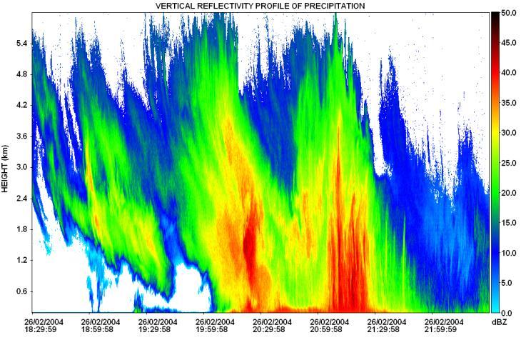


12 Vertical Profile of Reflectivity Rico-Ramirez et al (2007), Met Apps
 Rico-Ramirez et al (2005), Atmos")
13 Real-time bright band correction Kitchen et al (1994) Rico-Ramirez et al (2005), Atmos Letters
14 Clutter signals in weather radars Clutter are those unwanted echoes on weather radar scans: Fixed ground echoes (predictable) Anomalous propagation echoes (unpredictable) Sea echoes (unpredictable) Birds, airplanes, ships (unpredictable) Wind Farms

15 Clutter and Anomalous Propagation

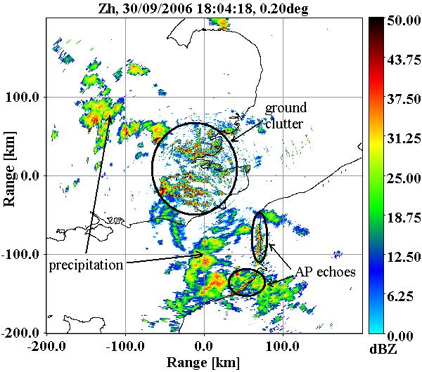
16 Precipitation and clutter
17 Normalised PDFs to classify clutter (ground & anaprop echoes) and precipitation clutter precipitation Radar measurement ),..., ( ) ( ) ( ),..., ( n n i i n x x P c x P c P x x c P Rico-Ramirez and Cluckie (2008), IEEE TGRS.
 = 78% (Zh), 93% (Zh, V), 98% (polarimetric radar) Rico-Ramirez and Cluckie (2008), IEEE")
18 Clutter removal using a Bayes classifier Raw reflectivity Clutter Corrected Reflectivity Classification performance (CSI) = 78% (Zh), 93% (Zh, V), 98% (polarimetric radar) Rico-Ramirez and Cluckie (2008), IEEE TGRS.


19 Extreme Events severe attenuation Chenies radar Thurnham radar 20th July 2007
 20 mm/h Uniform rain rate of 20 mm/h 10")
20 5 db (10 GHz) (5.5 GHz) 1 db PIA=0.1 db (3 GHz) 20 mm/h Uniform rain rate of 20 mm/h 10 km path Bringi et al

21 Attenuation Correction: 20 th July 2007 Raw reflectivity Attenuation-corrected reflectivity A h K dp
22 Attenuation correction Rico-Ramirez (2012) IEEE TGRS.
23 Attenuation correction results Errors: Rico-Ramirez (2012) IEEE TGRS.
24 Composite rainfall estimation R az Eq.1 b R a' Eq.2 b K dp ' R Eq.3 Z Z n dr Bringi et al (2011), J. of Hydrometeorology

25 Summer 2007 floods Total radar rain accumulation July 2007
26 Representativeness errors Fabry et al. (1994)
27 Variance between radar and gauges R r Radar rainfall (Att-uncorr) (Att-corr) 1.6 Z 200R var R r R g R g Gauge rainfall R a True Areal Rainfall var R g R a Bringi (2011), J. of Hydrometeorology
28 Areas where polarimetry can help Identification of non-meteorological echoes (Clutter & anomalous propagation) Attenuation correction Radar auto calibration Rainfall estimation (Zh, ZDR, KDP) Hydrometeor classification
29 Quantifying Radar Residual Errors However, despite significant progress to correct and adjust radar rainfall estimates, residual errors remain So, what can we do about it? We need to move towards a probabilistic approach: Evaluation of individual sources of error Computation of error covariance
30 Error Covariance E k xk ˆ 10log t, xk G t, xk / Rt, xk T C LL How to generate the perturbations? Finally, the perturbations are generated using: δ Ckk Var xk C, μ Ly kl t i t, i xk Cov, y N 0, I Taking into account the temporal correlation of the error: δ ' t, i Ly t, i a 1 δ ' t 1, i a2 δ ' t 2, i δ t, i μ v δ' t, i t, i Φ t, i 10log Rt, i t, i 10log δ xl Germann et al. (2009), QJRMS
31 Study Area >200 tbr EA raingauges UKMO 1km/5min Urban area: 15 flow monitors, 7 depth monitors 4-6 raingauges Additional raingauges from Bradford CC Data sets:
 in")
32 Mear error (G/R) in db


33 Mear error (G/R) in db
34 Temporal correlation of the error


35 Example of perturbations ( t,i ) t t+1 t
 t t+1 t+2... 1... 2")
36 Example of radar ensembles ( t,i ) t t+1 t
37 How many ensembles?

38 Urban catchment model
39 Urban catchment, schematic Liguori et al (2012), Atmospheric Research
40 Ensemble flow simulations Average rain 10.8mm
41 Ensemble flow simulations Average rain 10.1mm

42 Ensemble flow simulations Average rain 53.3mm * Additional uncertainties are coming from the hydraulic model
43 Precipitation Forecasting Radar advection-based methods are known as radar nowcasts. They start with high initial skill, which decreases with forecasting lead time as growth/decays processes are not resolved. Numerical Weather Models (NWP) take into account growth/decay processes, but they have a lower skill at the beginning of the forecast. However, the skill remains more or less constant with forecasting lead time.
44 Forecast skill vs forecasting time Austin, et al., (1987) Golding, (1998) Lin et al., (2005)
45 Radar Scans T-2 T-1 T How to calculate: T+1, T+2,, T+24?
46 Radar Extrapolation Forecasting Methods Use of correlation techniques Tracking radar echoes by correlation (Rinehart & Garvey, (1995)) Tracking of centroids of rain cells Use of NWP advection techniques Spectral decomposition & optical flow (Bowler et al, 2004, J. Hydrology) Merged techniques (Nowcast+NWPs): STEPS (Short-term ensemble prediction system) (Bowler et al, 2006, QJRMS)

")
47 Nowcasting (Spectral decomposition & optical flow) RADAR RADAR FORECASTS
 Radar Radar")
48 Nowcasting (Spectral decomposition & optical flow) Radar Radar Forecasts
49 Uncertainties in nowcasting Uncertainty in radar rainfall estimations Uncertainty in the nowcasting model: Tracking Growths & decays processes not taken into account
50 Probabilistic Nowcasts (example T+3h) DET E1 E2 E3 E4 E5
51 Numerical Weather Prediction Models RADAR NWP Forecasts Additional uncertainties come from NWP forecasts
52 Nowcasts+NWP Merging (e.g. STEPS) MERGED FORECAST
53 NOWCASTING MERGED Predictability of radar nowcasting & merged forecasts Forecast lead time Liguori & Rico-Ramirez (2012), Hydrological Processes


54 Probabilistic Flood Forecasting Source: EA Liguori & Rico-Ramirez (2013), Hydrological Processes
55 Concluding comments (QPE) Radar is the only way to estimate rainfall over a large area and in real-time Radar rainfall error increases with distance from the radar location, and in hilly areas Polarimetry can help to improve data quality (e.g. discriminate non-meteorological echoes, attenuation correction, rainfall estimation), but VPR will remain one of the largest sources of errors. Improving radar coverage & use of high-resolution radars can help. Real-time radar/gauge merging might help to reduce errors Radar rainfall errors can be modelled by using the error covariance matrix, but this has to be recomputed if new radar corrections are used.
56 Concluding comments (QPF) Forecast skill is a function of spatial scales (i.e. the smallest scales are less predictable) Forecast skill is a function of rainfall intensity (i.e. the most intensive rain cells are less predictable) There is more work to do to model uncertainties in nowcasting models by incorporating more meteorological knowledge There is more work to do to use ensemble radar rainfall forecasts in urban flood forecasting. The future is data assimilation.
57 Acknowledgements The Engineering and Physical Sciences Research Council, grant EP/I012222/1 UK Met Office, Environment Agency, Yorkshire Water Services LTD, Bradford City Council, British Atmospheric Data Centre National Centre for Atmospheric Research Thanks!
Weather radar rainfall for hydrological hazard risk management
 Weather radar rainfall for hydrological hazard risk management Dawei Han 韩大卫 Department of Civil Engineering University of Bristol, UK Hydrological hazards related to rainfall Floods Droughts Debris flows
Radars, Hydrology and Uncertainty
 Radars, Hydrology and Uncertainty Francesca Cecinati University of Bristol, Department of Civil Engineering francesca.cecinati@bristol.ac.uk Supervisor: Miguel A. Rico-Ramirez Research objectives Study
Comparing two different methods to describe radar precipitation uncertainty
 Comparing two different methods to describe radar precipitation uncertainty Francesca Cecinati, Miguel A. Rico-Ramirez, Dawei Han, University of Bristol, Department of Civil Engineering Corresponding author:
Utilization of Dual-pol data
 WMO/ASEAN Training Workshop on Weather Radar Data Quality and Standardization Utilization of Dual-pol data 8 February 2018 Hiroshi Yamauchi Observation Department Japan Meteorological Agency Japan Meteorological
1. Introduction. 2. The data. P13.15 The effect of a wet radome on dualpol data quality
 P3.5 The effect of a wet radome on dualpol data quality Michael Frech Deutscher Wetterdienst Hohenpeissenberg Meteorological Observatory, Germany. Introduction Operational radar systems typically are equipped
Recent progress in radar-based rainfall observations over Belgium. PLURISK Final Symposium Brussels, 4 October 2017
 Recent progress in radar-based rainfall observations over Belgium Laurent Delobbe Royal Meteorological Institute of Belgium with contributions from Lesley De Cruz, Loris Foresti, Edouard Goudenhoofdt,
and hydrological applications
 Overview of QPE/QPF techniques and hydrological applications Siriluk Chumchean Department of Civil Engineering Mahanakorn University of Technology Typhoon Committee Roving Seminar 2011, Malaysia (20-23
Radar-based pluvial flood forecasting over urban areas: Redbridge case study
 Weather Radar and Hydrology (Proceedings of a symposium held in Exeter, UK, April 2) (IAHS Publ. 3XX, 2). Radar-based pluvial flood forecasting over urban areas: Redbridge case study L. WANG, N. SIMÕES,
Aurora Bell*, Alan Seed, Ross Bunn, Bureau of Meteorology, Melbourne, Australia
 15B.1 RADAR RAINFALL ESTIMATES AND NOWCASTS: THE CHALLENGING ROAD FROM RESEARCH TO WARNINGS Aurora Bell*, Alan Seed, Ross Bunn, Bureau of Meteorology, Melbourne, Australia 1. Introduction Warnings are
Quantitative Flood Forecasts using Short-term Radar Nowcasting
 Quantitative Flood Forecasts using Short-term Radar Nowcasting Enrique R. Vivoni *, Dara Entekhabi *, Rafael L. Bras *, Matthew P. Van Horne *, Valeri Y. Ivanov *, Chris Grassotti + and Ross Hoffman +
Polarization Diversity for the National Weather Service (NWS), WSR-88D radars
, WSR-88D radars") Polarization Diversity for the National Weather Service (NWS), WSR-88D radars Dusan S. Zrnic National Severe Storm Laboratory Norman, OK 73069, USA In the early eighties the NOAA s National Severe Storms
Polarization Diversity for the National Weather Service (NWS), WSR-88D radars Dusan S. Zrnic National Severe Storm Laboratory Norman, OK 73069, USA In the early eighties the NOAA s National Severe Storms
Assimilation of Doppler radar observations for high-resolution numerical weather prediction
 Assimilation of Doppler radar observations for high-resolution numerical weather prediction Susan Rennie, Peter Steinle, Mark Curtis, Yi Xiao, Alan Seed Introduction Numerical Weather Prediction (NWP)
Huw W. Lewis *, Dawn L. Harrison and Malcolm Kitchen Met Office, United Kingdom
 2.6 LOCAL VERTICAL PROFILE CORRECTIONS USING DATA FROM MULTIPLE SCAN ELEVATIONS Huw W. Lewis *, Dawn L. Harrison and Malcolm Kitchen Met Office, United Kingdom 1. INTRODUCTION The variation of reflectivity
Convective Structures in Clear-Air Echoes seen by a Weather Radar
 Convective Structures in Clear-Air Echoes seen by a Weather Radar Martin Hagen Deutsches Zentrum für Luft- und Raumfahrt Oberpfaffenhofen, Germany Weather Radar Weather radar are normally used to locate
Tropical Rainfall Rate Relations Assessments from Dual Polarized X-band Weather Radars
 Tropical Rainfall Rate Relations Assessments from Dual Polarized X-band Weather Radars Carlos R. Wah González, José G. Colom Ustáriz, Leyda V. León Colón Department of Electrical and Computer Engineering
118 RECONSTRUCTION OF RADAR RFLECTIVITY IN CLUTTER AREAS
 8 RECONSTRUCTION OF RADAR RFLECTIVITY IN CLUTTER AREAS Shinju Park, Marc Berenguer Centre de Recerca Aplicada en Hidrometeorologia, Universitat Politècnica de Catalunya (BarcelonaTech), Barcelona, Spain..
Radar-raingauge data combination techniques: A revision and analysis of their suitability for urban hydrology
 9th International Conference on Urban Drainage Modelling Belgrade 2012 Radar-raingauge data combination techniques: A revision and analysis of their suitability for urban hydrology L. Wang, S. Ochoa, N.
On the use of radar rainfall estimates and nowcasts in an operational heavy rainfall warning service
 On the use of radar rainfall estimates and nowcasts in an operational heavy rainfall warning service Alan Seed, Ross Bunn, Aurora Bell Bureau of Meteorology Australia The Centre for Australian Weather
REQUIREMENTS FOR WEATHER RADAR DATA. Review of the current and likely future hydrological requirements for Weather Radar data
 WORLD METEOROLOGICAL ORGANIZATION COMMISSION FOR BASIC SYSTEMS OPEN PROGRAMME AREA GROUP ON INTEGRATED OBSERVING SYSTEMS WORKSHOP ON RADAR DATA EXCHANGE EXETER, UK, 24-26 APRIL 2013 CBS/OPAG-IOS/WxR_EXCHANGE/2.3
Evaluation and correction of uncertainty due to Gaussian approximation in radar rain gauge merging using kriging with external drift
 Evaluation and correction of uncertainty due to Gaussian approximation in radar rain gauge merging using kriging with external drift F. Cecinati* 1, O. Wani 2,3, M. A. Rico-Ramirez 1 1 University of Bristol,
Snow Microphysical Retrieval Based on Ground Radar Measurements
 Snow Microphysical Retrieval Based on Ground Radar Measurements V. Chandrasekar Colorado State University June 27, 2007 1 Outline Role of inter comparing ground and space borne radar Class of measurements
Study on the rainfall dependence structure using radar and rain gauge data
 International Workshop Advances in Statistical hydrology, May 23-25 2010, Taormina, Italy Study on the rainfall dependence structure using radar and rain gauge data V. Montesarchio, F. Russo, F. Napolitano
The Radar Quality Control and Quantitative Precipitation Estimation Intercomparison Project. RQQI (pronounced Rickey)
") The Radar Quality Control and Quantitative Precipitation Estimation Intercomparison Project RQQI (pronounced Rickey) Paul Joe and Alan Seed Environment Canada Centre for Australian Weather and Climate
The Radar Quality Control and Quantitative Precipitation Estimation Intercomparison Project RQQI (pronounced Rickey) Paul Joe and Alan Seed Environment Canada Centre for Australian Weather and Climate
Uncertainty in merged radar - rain gauge rainfall products
 Uncertainty in merged radar - rain gauge rainfall products Francesca Cecinati University of Bristol francesca.cecinati@bristol.ac.uk Supervisor: Miguel A. Rico-Ramirez This project has received funding
A new mesoscale NWP system for Australia
 A new mesoscale NWP system for Australia www.cawcr.gov.au Peter Steinle on behalf of : Earth System Modelling (ESM) and Weather&Environmental Prediction (WEP) Research Programs, CAWCR Data Assimilation
Lei Feng Ben Jong-Dao Jou * T. D. Keenan
 P2.4 CONSIDER THE WIND DRIFT EFFECTS IN THE RADAR-RAINGAUGE COMPARISONS Lei Feng Ben Jong-Dao Jou * T. D. Keenan National Science and Technology Center for Disaster Reduction, Taipei County, R.O.C National
Measurements of a network of mobile radars during the experimental campaign of the HydroRad project
 ERAD 2012 - THE SEVENTH EUROPEAN CONFERENCE ON RADAR IN METEOROLOGY AND HYDROLOGY Measurements of a network of mobile radars during the experimental campaign of the HydroRad project Kalogiros J. 1, Anagnostou
A real-time procedure for adjusting radar data using raingauge information II: Initial performance of the PMM procedure
 A real-time procedure for adjusting radar data using raingauge information II: Initial performance of the PMM procedure C. G. Collier 1, J. Black 1,2, J. Powell 2, R. Mason 2 l National Centre for Atmospheric
A high-resolution radar experiment on the island of Jersey
 METEOROLOGICAL APPLICATIONS Meteorol. Appl. 14: 117 19 (7) Published online in Wiley InterScience (www.interscience.wiley.com) DOI: 1.1/met.13 A high-resolution radar experiment on the island of Jersey
ERAD THE SIXTH EUROPEAN CONFERENCE ON RADAR IN METEOROLOGY AND HYDROLOGY
 Real-time adjustment of radar data for water management systems using a PDF technique: The City RainNet Project Chris. G. Collier 1, Rod Hawnt 2 and John Powell 2 1. National Centre for Atmospheric Science,
What s New in the NWS? Georgia Association of Floodplain Management. Lans P. Rothfusz Meteorologist in Charge Peachtree City, GA 27 March 2012
 What s New in the NWS? Georgia Association of Floodplain Management Lans P. Rothfusz Meteorologist in Charge Peachtree City, GA 27 March 2012 Overview Summer Outlook Radar future is here! CoCoRAHS Appeal
Probabilistic forecasting for urban water management: A case study
 9th International Conference on Urban Drainage Modelling Belgrade 212 Probabilistic forecasting for urban water management: A case study Jeanne-Rose Rene' 1, Henrik Madsen 2, Ole Mark 3 1 DHI, Denmark,
Error Propagation from Radar Rainfall Nowcasting Fields to a Fully-Distributed Flood Forecasting Model
 Error Propagation from Radar Rainfall Nowcasting Fields to a Fully-Distributed Flood Forecasting Model Enrique R. Vivoni 1, Dara Entekhabi 2 and Ross N. Hoffman 3 1. Department of Earth and Environmental
The impact of wet radome on the quality of polarimetric measurements. January 5, 2010
 The impact of wet radome on the quality of polarimetric measurements 1. Introduction January 5, 2010 It is well known that wet radome causes attenuation of microwave radiation. Such a transmission loss
FLORA: FLood estimation and forecast in complex Orographic areas for Risk mitigation in the Alpine space
 Natural Risk Management in a changing climate: Experiences in Adaptation Strategies from some European Projekts Milano - December 14 th, 2011 FLORA: FLood estimation and forecast in complex Orographic
A ZDR Calibration Check using Hydrometeors in the Ice Phase. Abstract
 A ZDR Calibration Check using Hydrometeors in the Ice Phase Michael J. Dixon, J. C. Hubbert, S. Ellis National Center for Atmospheric Research (NCAR), Boulder, Colorado 23B.5 AMS 38 th Conference on Radar
Observation strategies for severe rain in The Netherlands
 Observation strategies for severe rain in The Netherlands Herman Russchenberg Delft University of Technology Challenge the future Our Earth is slowly warming The world population is moving into the cities
QPE and QPF in the Bureau of Meteorology
 QPE and QPF in the Bureau of Meteorology Current and future real-time rainfall products Carlos Velasco (BoM) Alan Seed (BoM) and Luigi Renzullo (CSIRO) OzEWEX 2016, 14-15 December 2016, Canberra Why do
an experiment to assess the hydrological value of a portable X-band radar
 ERAD 12 - THE SEVENTH EUROPEAN CONFERENCE ON RADAR IN METEOROLOGY AND HYDROLOGY RAINSCANNER@Barcelona: an experiment to assess the hydrological value of a portable X-band radar Marc Berenguer1, Shinju
WP2: Fine-scale rainfall data acquisition and prediction:
 WP1 WP2: Fine-scale rainfall data acquisition and prediction: Objective: develop and implement a system for estimation and forecasting of fine-scale (100m, minutes) rainfall Rainfall estimation: combining
Chapter 2: Polarimetric Radar
 Chapter 2: Polarimetric Radar 2.1 Polarimetric radar vs. conventional radar Conventional weather radars transmit and receive linear electromagnetic radiation whose electric field is parallel to the local
Representing radar rainfall uncertainty with ensembles based on a time-variant geostatistical error modelling approach
 Representing radar rainfall uncertainty with ensembles based on a time-variant geostatistical error modelling approach Bristol, 4 th March 2016 Francesca Cecinati Background M.Eng. Environmental and Water
Nowcasting for New Zealand
 ATMOSPHERIC SCIENCE LETTERS Atmos. Sci. Let. 6: 35 39 (2005) Published online in Wiley InterScience (www.interscience.wiley.com). DOI: 10.1002/asl.88 Nowcasting for New Zealand Warren Gray, 1 * Howard
TESTS OF QUANTITATIVE PRECIPITATION ESTIMATES USING NATIONAL WEATHER SERVICE DUAL-POLARIZATION RADAR IN MISSOURI
 TESTS OF QUANTITATIVE PRECIPITATION ESTIMATES USING NATIONAL WEATHER SERVICE DUAL-POLARIZATION RADAR IN MISSOURI A Thesis Presented to the Faculty of the Graduate School at the University of Missouri In
Fundamentals of Radar Display. Atmospheric Instrumentation
 Fundamentals of Radar Display Outline Fundamentals of Radar Display Scanning Strategies Basic Geometric Varieties WSR-88D Volume Coverage Patterns Classic Radar Displays and Signatures Precipitation Non-weather
Progress in Operational Quantitative Precipitation Estimation in the Czech Republic
 Progress in Operational Quantitative Precipitation Estimation in the Czech Republic Petr Novák 1 and Hana Kyznarová 1 1 Czech Hydrometeorological Institute,Na Sabatce 17, 143 06 Praha, Czech Republic (Dated:
DETECTION AND FORECASTING - THE CZECH EXPERIENCE
 1 STORM RAINFALL DETECTION AND FORECASTING - THE CZECH EXPERIENCE J. Danhelka * Czech Hydrometeorological Institute, Prague, Czech Republic Abstract Contribution presents the state of the art of operational
Radar precipitation measurement in the Alps big improvements triggered by MAP
 Radar precipitation measurement in the Alps big improvements triggered by MAP Urs Germann, Gianmario Galli, Marco Boscacci MeteoSwiss, Locarno-Monti MeteoSwiss radar Monte Lema, 1625m Can we measure precipitation
Assessment of QPE results from 4 kw X-band Local Area Weather Radar (LAWR) evaluated with S-band radar data
 evaluated with S-band radar data") Assessment of QPE results from 4 kw X-band Local Area Weather Radar (LAWR) evaluated with S-band radar data Lisbeth Pedersen 1+3, Isztar. Zawadzki 2, Niels Einar Jensen 1 and Henrik Madsen 3, (1) DHI,
Assessment of QPE results from 4 kw X-band Local Area Weather Radar (LAWR) evaluated with S-band radar data Lisbeth Pedersen 1+3, Isztar. Zawadzki 2, Niels Einar Jensen 1 and Henrik Madsen 3, (1) DHI,
Heavier summer downpours with climate change revealed by weather forecast resolution model
 SUPPLEMENTARY INFORMATION DOI: 10.1038/NCLIMATE2258 Heavier summer downpours with climate change revealed by weather forecast resolution model Number of files = 1 File #1 filename: kendon14supp.pdf File
Radar Network for Urban Flood and Severe Weather Monitoring
 Radar Network for Urban Flood and Severe Weather Monitoring V. Chandrasekar 1 and Brenda Philips 2 Colorado State University, United States University of Massachusetts, United States And the full DFW team
Improved radar QPE with temporal interpolation using an advection scheme
 Improved radar QPE with temporal interpolation using an advection scheme Alrun Jasper-Tönnies 1 and Markus Jessen 1 1 hydro & meteo GmbH & Co, KG, Breite Str. 6-8, 23552 Lübeck, Germany (Dated: 18 July
Rainfall estimation in mountainous regions using X-band polarimetric weather radar
 Rainfall estimation in mountainous regions using X-band polarimetric weather radar Shakti P.C. 1,2, M. Maki 1,2, S. Shimizu 2, T. Maesaka 2, D.-S. Kim 2, D.-I. Lee 3 and H. Iida 4 1 Graduate School of
Rainfall-runoff modelling using merged rainfall from radar and raingauge measurements
 Rainfall-runoff modelling using merged rainfall from radar and raingauge measurements Nergui Nanding, Miguel Angel Rico-Ramirez and Dawei Han Department of Civil Engineering, University of Bristol Queens
Improving precipitation estimates from weather radar using quality control and correction techniques
 Meteorol. Appl. 6, 135 144 (2000) Improving precipitation estimates from weather radar using quality control and correction techniques D L Harrison, S J Driscoll and M Kitchen, The Meteorological Office,
Observation Based Products Technical Report No. 13
 Observation Based Products Technical Report No. 13 Improving precipitation estimates from weather radar using quality control and correction techniques by D L Harrison, S J Driscoll & M Kitchen October
Quality control of weather radar data by using dual-polarization
 WMO/ASEAN Training Workshop on Weather Radar Data Quality and Standardization Quality control of weather radar data by using dual-polarization 7 February 2018 Hiroshi Yamauchi Observation Department Japan
STEPS-BE: an ensemble radar rainfall nowcasting system for urban hydrology in Belgium
 STEPS-BE: an ensemble radar rainfall nowcasting system for urban hydrology in Belgium Loris Foresti 1,2, Maarten Reyniers 2, Lesley De Cruz 2, Alan Seed 3 and Laurent Delobbe 2 with contributions from
ERAD THE EIGHTH EUROPEAN CONFERENCE ON RADAR IN METEOROLOGY AND HYDROLOGY
 ERAD 2014 - THE EIGHTH EUROPEAN CONFERENCE ON RADAR IN METEOROLOGY AND HYDROLOGY Microphysical interpretation of coincident simultaneous and fast alternating horizontal and vertical polarization transmit
Testing a Polarimetric Rainfall Algorithm and Comparison with a Dense Network of Rain Gauges.
 Testing a Polarimetric Rainfall Algorithm and Comparison with a Dense Network of Rain Gauges. Alexander Ryzhkov (1,2), Terry Schuur (1,2), Dusan Zrnic (1) 1 National Severe Storms Laboratory, 1313 Halley
Estimation of high spatial resolution precipitation fields using merged rain gauge - radar data. Antonio Manuel Moreno Ródenas
 Estimation of high spatial resolution precipitation fields using merged rain gauge - radar data. 0- Index 1. 2. Methods 3. Case study 4. Results and discussion 5. Conclusions. 1.- 1.- Fuentes Methods de
Radar-derived Quantitative Precipitation Estimation Using a Hybrid Rate Estimator Based On Hydrometeor Type
 Radar-derived Quantitative Precipitation Estimation Using a Hybrid Rate Estimator Based On Hydrometeor Type Michael J. Dixon, S. M. Ellis, T. M. Weckwerth and J. W. Wilson National Center for Atmospheric
HydroClass TM. Separating meteorological and non-meteorological targets in Vaisala radar systems. Laura C. Alku 8th July 2014
 HydroClass TM Separating meteorological and non-meteorological targets in Vaisala radar systems 8th July 2014 HydroClass Software for hydrometeor classification Uses dual polarization observations Utilizes
The development of a Kriging based Gauge and Radar merged product for real-time rainfall accumulation estimation
 The development of a Kriging based Gauge and Radar merged product for real-time rainfall accumulation estimation Sharon Jewell and Katie Norman Met Office, FitzRoy Road, Exeter, UK (Dated: 16th July 2014)
CIE4491 Lecture. How to quantify stormwater flow urban rainfall data and resolution Marie-claire ten Veldhuis
 CIE4491 Lecture. How to quantify stormwater flow urban rainfall data and resolution Marie-claire ten Veldhuis 18-9-2013 Delft University of Technology Challenge the future Coping with heavy rainfall -
Danish experiences with short term forecasting in urban drainage applications
 Danish experiences with short term forecasting in urban drainage applications RainGain workshop on fine-scale rainfall nowcasting 31 March 214, Antwerp Associate Professor Søren Thorndahl Department of
Estimation of Z-R relationship and comparative analysis of precipitation data from colocated rain-gauge, vertical radar and disdrometer
 Estimation of Z-R relationship and comparative analysis of precipitation data from colocated rain-gauge, vertical radar and disdrometer Isabel Cyr Civil and Environmental Engineering (2 year) Submission
A real-time procedure for adjusting radar data using raingauge information I: System description
 A real-time procedure for adjusting radar data using raingauge information I: System description J. Black 1,2, C. G. Collier 3, J. Powell 2, R. Mason 2 1 National Centre for Atmospheric Science, School
Improved rainfall estimates and forecasts for urban hydrological applications
 Improved rainfall estimates and forecasts for urban hydrological applications Innovyze User Days - Drainage and Flooding User Group Wallingford, 20 th June 2013 Contents 1. Context 2. Radar rainfall processing
P.083 SEVERE WEATHER EVENTS DETECTED BY PUERTO RICO S TROPINET DUAL-POLARIZED DOPPLER X-BAND RADARS NETWORK
 P.083 SEVERE WEATHER EVENTS DETECTED BY PUERTO RICO S TROPINET DUAL-POLARIZED DOPPLER X-BAND RADARS NETWORK Leyda León, José Colom, Carlos Wah University of Puerto Rico, Mayagüez Campus, Mayagüez, PR 1.
Lab 6 Radar Imagery Interpretation
 Lab 6 Radar Imagery Interpretation Background Weather radar (radio detection and ranging) is another very useful remote sensing tool used in meteorological forecasting. Microwave radar was developed in
TIME EVOLUTION OF A STORM FROM X-POL IN SÃO PAULO: 225 A ZH-ZDR AND TITAN METRICS COMPARISON
 TIME EVOLUTION OF A STORM FROM X-POL IN SÃO PAULO: 225 A ZH-ZDR AND TITAN METRICS COMPARISON * Roberto V Calheiros 1 ; Ana M Gomes 2 ; Maria A Lima 1 ; Carlos F de Angelis 3 ; Jojhy Sakuragi 4 (1) Voluntary
Predicting rainfall using ensemble forecasts
 Predicting rainfall using ensemble forecasts Nigel Roberts Met Office @ Reading MOGREPS-UK Convection-permitting 2.2 km ensemble now running routinely Embedded within MOGREPS-R ensemble members (18 km)
Development and verification of a real-time stochastic precipitation nowcasting system for urban hydrology in Belgium
 doi:10.5194/hess-20-505-2016 Author(s) 2016. CC Attribution 3.0 License. Development and verification of a real-time stochastic precipitation nowcasting system for urban hydrology in Belgium L. Foresti
A Study of the Error Covariance Matrix of Radar Rainfall Estimates in Stratiform Rain
 DECEMBER 2008 B E R E N G U E R A N D Z A W A D Z K I 1085 A Study of the Error Covariance Matrix of Radar Rainfall Estimates in Stratiform Rain MARC BERENGUER AND ISZTAR ZAWADZKI J. S. Marshall Radar
Rainfall estimation for the first operational S-band polarimetric radar in Korea
 Rainfall estimation for the first operational S-band polarimetric radar in Korea Cheol-Hwan You 1, Dong-In Lee 2, Mi-Young Kang 2 and Young-Su Bang 2 1 Atmospheric Environmental Research Institute, Pukyong
Challenges in providing effective flood forecasts and warnings
 Challenges in providing effective flood forecasts and warnings National Centre for Flood Research Inaugural Symposium Justin Robinson Bureau of Meteorology October 2018 Zero Lives Lost A key responsibility
Dual-Polarimetric Analysis of Raindrop Size Distribution Parameters for the Boulder Flooding Event of September 2013
 University of Alabama in Huntsville ATS690 Final Project Dual-Polarimetric Analysis of Raindrop Size Distribution Parameters for the Boulder Flooding Event of 11-12 September 2013 Author: Brian Freitag
Precipitation estimate of a heavy rain event using a C-band solid-state polarimetric radar
 Precipitation estimate of a heavy rain event using a C-band solid-state polarimetric radar Hiroshi Yamauchi 1, Ahoro Adachi 1, Osamu Suzuki 2, Takahisa Kobayashi 3 1 Meteorological Research Institute,
Quantitative Precipitation Estimation from C-band Dual-polarized radar for the July 08 th 2013 Flood in Toronto, Canada.
 Quantitative Precipitation Estimation from C-band Dual-polarized radar for the July 08 th 2013 Flood in Toronto, Canada. Sudesh Boodoo 1, David Hudak 1, Alexander Ryzhkov 2, Pengfei Zhang 2, Norman Donaldson
UP-TO-DATE RADAR-BASED PRODUCTS FOR POTENTIAL OPERATIONAL APPLICATION
 UP-TO-DATE RADAR-BASED PRODUCTS FOR POTENTIAL OPERATIONAL APPLICATION Heikki Pohjola and Uta Gjertsen OPERA work package 1.6 OPERA_2006_04 Final report, 31 st of October, 2006 Contents 1 Introduction 3
Improvement of quantitative precipitation estimates in Belgium
 Improvement of quantitative precipitation estimates in Belgium L. Delobbe, E. Goudenhoofdt, and B. Mohymont Royal Meteorological Institute of Belgium 1. Introduction In this paper we describe the recent
Advances in weather modelling
 Advances in weather modelling www.cawcr.gov.au Robert Fawcett - speaking on behalf of CAWCR Earth-System Modelling and CAWCR Weather and Environmental Prediction May 2013 The Centre for Australian Weather
Investigating synergies between weather radar data and mesoscale model output
 Department of Meteorology University of Reading Investigating synergies between weather radar data and mesoscale model output Marion Petra Mittermaier A thesis submitted for the degree of Doctor of Philosophy
Hydraulic Modelling for Real Time Flood Forecast Applications
 BHS/CIWEM SW Branch Meeting Hydraulic Modelling for Real Time Flood Forecast Applications Yiping Chen 20 June 2007 Introduction Hydraulic River Modelling: Washland (Floodplain) Modelling Techniques Integrated
Skill in nowcasting high-impact heavy precipitation events
 Skill in nowcasting high-impact heavy precipitation events Joan Bech 1 and Marc Berenguer 2 1 Departament d'astronomia i Meteorologia,Facultat de Física. Universitat de Barcelona. Marti i Franqués 1, Barcelona
DATA FUSION NOWCASTING AND NWP
 DATA FUSION NOWCASTING AND NWP Brovelli Pascal 1, Ludovic Auger 2, Olivier Dupont 1, Jean-Marc Moisselin 1, Isabelle Bernard-Bouissières 1, Philippe Cau 1, Adrien Anquez 1 1 Météo-France Forecasting Department
Probabilistic Quantitative Precipitation Forecasts for Tropical Cyclone Rainfall
 Probabilistic Quantitative Precipitation Forecasts for Tropical Cyclone Rainfall WOO WANG CHUN HONG KONG OBSERVATORY IWTCLP-III, JEJU 10, DEC 2014 Scales of Atmospheric Systems Advection-Based Nowcasting
Vertical Variability of the Raindrop Size Distribution and Its Effects on Dual-polarimetric Radar QPE
 Vertical Variability of the Raindrop Size Distribution and Its Effects on Dual-polarimetric Radar QPE Patrick N. Gatlin University of Alabama Huntsville June 12, 2015 Overview Weather radar is a more economical
Comparison of polarimetric techniques for precipitation estimation in Serbia
 Comparison of polarimetric techniques for precipitation estimation in Serbia Zoran Vucinic 1 and Julijana Nadj 2 1 Republic Hydrometeorological Service of Serbia, Kneza Viseslava 66, 11030 Belgrade, Serbia
Improving Operational Use of Scanning Rain Radar Estimates with Vertically Pointing Radar
 Improving Operational Use of Scanning Rain Radar Estimates with Vertically Pointing Radar Luke Sutherland-Stacey Weather Radar NZ www.weatherradar.co.nz Tom Joseph Mott MacDonald Geoff Austin Weather Radar
B.W.Golding * Met Office, Exeter, UK
 7.35 A NEW APPROACH TO NOWCASTING AT THE MET OFFICE B.W.Golding * Met Office, Exeter, UK 1. BACKGROUND * The Nimrod system was introduced into operational use in the Met Office in 1996 (Golding, 1998).
Sensor networks and urban pluvial flood modelling in an urban catchment
 Environmental virtual observatories: managing catchments with wellies, sensors and smartphones Sensor networks and urban pluvial flood modelling in an urban catchment 28 th February 2013 Contents 1. Context
Hail nowcast exploiting radar and satellite observations
 Federal Department of Home Affairs FDHA Federal Office of Meteorology and Climatology MeteoSwiss Hail nowcast exploiting radar and satellite observations Ulrich Hamann, Elena Leonarduzzi, Kristopher Bedka,
A FIELD STUDY TO CHARACTERISE THE MEASUREMENT OF PRECIPITATION USING DIFFERENT TYPES OF SENSOR. Judith Agnew 1 and Mike Brettle 2
 A FIELD STUDY TO CHARACTERISE THE MEASUREMENT OF PRECIPITATION USING DIFFERENT TYPES OF SENSOR Judith Agnew 1 and Mike Brettle 2 1 STFC Rutherford Appleton Laboratory, Harwell Oxford, Didcot, Oxfordshire,
DSD characteristics of a cool-season tornadic storm using C-band polarimetric radar and two 2D-video disdrometers
 DSD characteristics of a cool-season tornadic storm using C-band polarimetric radar and two 2D-video disdrometers M. Thurai 1, W. A. Petersen 2, and L. D. Carey 3 1 Colorado State University, Fort Collins,
Application of Radar QPE. Jack McKee December 3, 2014
 Application of Radar QPE Jack McKee December 3, 2014 Topics Context Precipitation Estimation Techniques Study Methodology Preliminary Results Future Work Questions Introduction Accurate precipitation data
Heavy precipitation events over Liguria (Italy): high-resolution hydro-meteorological forecasting and rainfall data assimilation
: high-resolution hydro-meteorological forecasting and rainfall data assimilation") Dublin, 08 September 2017 Heavy precipitation events over Liguria (Italy): high-resolution hydro-meteorological forecasting and rainfall data assimilation Silvio Davolio 1, Francesco Silvestro 2, Thomas
Dublin, 08 September 2017 Heavy precipitation events over Liguria (Italy): high-resolution hydro-meteorological forecasting and rainfall data assimilation Silvio Davolio 1, Francesco Silvestro 2, Thomas
NOTES AND CORRESPONDENCE. A Comparison of Radar Reflectivity Estimates of Rainfall from Collocated Radars
 1264 JOURNAL OF ATMOSPHERIC AND OCEANIC TECHNOLOGY VOLUME 16 NOTES AND CORRESPONDENCE A Comparison of Radar Reflectivity Estimates of Rainfall from Collocated Radars EDWARD A. BRANDES, J.VIVEKANANDAN,
Simulation of polarimetric radar variables in rain at S-, C- and X-band wavelengths
 Adv. Geosci., 16, 27 32, 28 www.adv-geosci.net/16/27/28/ Author(s) 28. This work is distributed under the Creative Commons Attribution 3. License. Advances in Geosciences Simulation of polarimetric radar