STORM SURGE EVACUATION GUIDE
|
|
|
- Katrina Goodwin
- 6 years ago
- Views:
Transcription


1 STORM SURGE EVACUATION GUIDE STORM TIDE EVACUATION MAPS


2 Living in a cyclone prone region triggers a need for a heightened level of awareness in our community... All threats outlined in the Hinchinbrook Shire Local Disaster Management Plan have the potential to, at some time, warrant an evacuation of certain areas within our community. A copy of the Hinchinbrook Shire Local Disaster Management Plan can be found on the Hinchinbrook Shire Council website. It is the nature of our location, that we could become threatened by tropical cyclones and storm tide inundation, which emphasises the fact that we must be prepared for the cyclone season. In the event of a cyclone approaching our coastline, an evacuation will only be ordered if it is identified that a storm tide surge is likely to occur in developed areas. For this reason it is important that you familiarise yourself with this guide so you are aware of your zone, if you are required to evacuate in the event of a storm surge. STORM SURGE...what is it? A storm surge is a rise above the normal ocean level as a result of onshore winds and/or reduced atmospheric pressure. Storm surges accompany a tropical cyclone as it comes ashore. They may also be formed by intense low-pressure systems in non-tropical areas. The combination of storm surge and normal (astronomical) tide is known as a storm tide. The most vulnerable time a storm surge can arrive is on top of a high tide, which can inundate areas which could otherwise be safe. HOW HIGH WILL THE STORM SURGE BE? The height of the storm surge varies depending on several factors being: The intensity of the cyclone stronger winds allow for increase in wave height and the sea water is piled on top of this The movement of the cyclone the faster the cyclone crosses the coast, the quicker the surge will build up and create a more powerful impact when it hits the coastline The angle the cyclone crosses the coast a direct hit will encourage a larger surge, but other angles can lead to local zones of enhanced surge in areas such as narrow inlets and bays The profile of the sea floor - a shallow coastline allows the surge to increase strength, whereas steep slopes or fringing reefs can allow the surge to be less Topography of the area islands, bays, and headlands can amplify the storm surge Disaster Management QLD Disaster Management QLD WHAT IF I AM IN A STORM SURGE AREA? Make arrangements with friends or family who live in a safe place No friends in a safe place...evacuate to your nearest community evacuation centre In the event of an evacuation, emergency service workers may doorknock your street to direct you to a safer place Ensure all electrical/gas appliances are turned off before you leave Remember your emergency kit when you leave 2 I Storm Tide Evacuation Guide

3 CYCLONES A tropical cyclone is defined as a non-frontal low pressure system of synoptic scale developing over warm waters having organised convection and a maximum mean wind speed of 34 knots or greater extending more than half-way around near the centre and persisting for at least six hours. The severity of a tropical cyclone is described in terms of categories ranging from 1 (weakest) to 5 (strongest) related to the maximum mean wind speed as shown in this table: Category Maximum Mean Wind (km/h) Typical Strongest Gust (km/h) Central Pressure (hpa) Typical Effects < 125 > 985 Negligible house damage Damage to some crops, trees and caravans Craft may drag moorings Minor house damage Significant damage to signs, trees and caravans Heavy damage to some crops Risk of power failure Small craft may break moorings Some roof and structural damage Some caravans destroyed Power failures likely (e.g. Winifred) Significant roofing loss and structural damage Many caravans destroyed and blown away Dangerous airborne debris Widespread power failures (e.g. Tracy, Olivia) 5 > 200 > 279 < 930 Extremely dangerous with widespread destruction (e.g. Vance) Storm Tide Evacuation Guide I 3

 Wet weather clothing eg.")

4 BE PREPARED CHECKLIST FOR EVACUATION Do you know the evacuation zone in your area? What is your zone colour? Is your zone currently under threat? Do you know your emergency evacuation route? Have you heard any official advice to evacuate? Have you packed your emergency evacuation kit? Is your vehicle full of fuel? PREPARE YOUR EMERGENCY KIT Portable radio with fresh spare batteries Torch, fuel lamp, candles and matches Non-perishable food, (three days supply) plus can opener, self contained cooking gear, plates and utensils Clean water in sealed containers and spare water containers (10L per person is recommended to last three days) Wet weather clothing eg. waterproof jacket, hat and spare clothes Medical supplies to last at least 14 days First aid kit Knife, whistle, duct/masking tape, and plastic (garbage) bags Tarpaulin and blankets Pet food, water bowls and other pet needs DURING A NATURAL DISASTER ALERT Listen to your portable radio constantly Close up the house - secure doors, board or tape windows and secure outdoor furniture Disconnect electrical appliances Secure your pets in a safe place Fill water containers Fuel car and place under cover Remain indoors with your emergency kit Be prepared to leave your house in the event of a storm tide evacuation IMPORTANT CONTACTS Life Threatening Emergencies Police, Ambulance, Fire 000 SES Assistance Road Information Hinchinbrook Shire Council Emergency Queensland/SES Bureau of Meteorology Traffic Management Centre Hinchinbrook Shire Council 4 I Storm Tide Evacuation Guide

5 EVACUATION MAPS The following evacuation maps are used to inform residents of predicted storm time flooding associated with a tropical cyclone, and to identify areas that may require evacuation. Three evacuation zones have been identified in the Hinchinbrook region Red, Orange and Yellow. In the event of a storm tide, authorities will issue an evacuation for the required zones. Evacuation zones were developed using results from Council s Storm Surge Study of the coastal communities located within the Hinchinbrook Shire Council including Lucinda, Dungeness, Taylors Beach, Forrest Beach and Cassady Beach. Any properties on the coastline, but outside of these areas may still be vulnerable to a storm tide. Residents outside of the study area should consider their individual situation and what actions they may need to take in the event of a storm tide. It is important that prior and during the disaster you stay tuned to local ABC or commercial radio and TV stations for updates. EVACUATION ZONE If an evacuation order is announced for a Red, Orange or Yellow zone, affected residents should move out of the area using the most direct evacuation route. RED ZONE: These properties face the highest risk of coastal flooding from a storm tide. They may experience flooding in areas located up to 2 and 3 metres above AHD. ORANGE ZONE: These properties face a high risk of coastal flooding from a storm tide. They may experience flooding in areas located between 3 and 4 metres above AHD. YELLOW ZONE: These properties face a moderate risk of coastal flooding form a storm tide. They may experience flooding in areas located between 4 and 6 metres above AHD. Australian Height Datum (AHD): is the term used to describe the reference level for defining ground levels in Australia. The level of 0.0m AHD is approximately sea level. IF YOU LIVE IN A COASTAL COMMUNITY A STORM TIDE EVACUATION STICKER IDENTIFYING YOUR ZONE SHOULD BE LOCATED INSIDE YOUR ELECTRICAL METER BOX HOW TO USE THE STORM TIDE EVACUATION MAPS Identify your property on the Storm Tide Evacuation Map or locate the evacuation sticker in your electrical meter box Remember and record the colour of your zone, so you are aware during a storm tide event If your property is not coloured it means you are not in a nominated evacuation zone Identify the primary and/or alternative route so you are prepared in the event of an evacuation DISCLAIMER Storm Tide Evacuation Zones are based upon geographical data from the National Storm Tide Mapping program. Evacuation Zones are designed to provide an easy to understand method for the public to identify coastal areas that may be affected by storm tides caused by tropical cyclones or severe east coast storms. Every effort has been made to ensure that the information contained with this Storm Tide Evacuation Guide and Public Information Maps is accurate. However, Hinchinbrook Shire Council does not give any warranty or accept any liability in relation to the content of these maps. Storm Tide Evacuation Guide I 5
6 HINCHINBROOK SHIRE COUNCIL LEGEND Key Plan DCDB Feb 2011 Water Map 1 LUCINDA Map 2 TAYLORS BEACH Map 3 Map 4 FORREST BEACH Map ,500 3,000 4,500 6,000 Meters Data Sources & Acknowledgements Storm Tide Evacuation Zones are based upon geographical data from the National Storm Tide Mapping program. Evacuation Zones are designed to provide an easy to understand method for the public to identify coastal areas that may be affected by storm tides caused by tropical cyclones or severe east coast storms. Every effort has been made to ensure that the information contained within these Public Information Maps is accurate. However, Hinchinbrook Shire Council does not give any warranty or accept any liability in relation to the content of these maps. Cadastral Information sourced from Department of Environment and Resource Management is current to February 2011 and is accurate 1:50,000. Copyright Department of Environment and Resource Management 2011 STORM TIDE EVACUATION ZONES - KEY PLAN O
7 HINCHINBROOK SHIRE COUNCIL Dungeness Road LEGEND Evacuation Routes Road Names Street Numbering DCDB Storm Tide Evacuation Zones Evacuation Zone Red Zone Orange Zone Yellow Zone Keast Street Patterson Parade Patterson Parade Lucinda Point Road Meters Data Sources & Acknowledgements Storm Tide Evacuation Zones are based upon geographical data from the National Storm Tide Mapping program. Evacuation Zones are designed to provide an easy to understand method for the public to identify coastal areas that may be affected by storm tides caused by tropical cyclones or severe east coast storms. Every effort has been made to ensure that the information contained within these Public Information Maps is accurate. However, Hinchinbrook Shire Council does not give any warranty or accept any liability in relation to the content of these maps. Cadastral Information sourced from Department of Environment and Resource Management is current to February 2011 and is accurate 1:50,000. Copyright Department of Environment and Resource Management 2011 STORM TIDE EVACUATION ZONES - LUCINDA MAP 1 O
8 Taylors Beach Road HINCHINBROOK SHIRE COUNCIL LEGEND Evacuation Routes DCDB Feb 2011 Storm Tide Evacuation Zones Evacuation Zone Red Zone Orange Zone Yellow Zone Barramundi Street Trevally Street Bream Street John Dory Street Meters Data Sources & Acknowledgements Storm Tide Evacuation Zones are based upon geographical data from the National Storm Tide Mapping program. Evacuation Zones are designed to provide an easy to understand method for the public to identify coastal areas that may be affected by storm tides caused by tropical cyclones or severe east coast storms. Every effort has been made to ensure that the information contained within these Public Information Maps is accurate. However, Hinchinbrook Shire Council does not give any warranty or accept any liability in relation to the content of these maps. Cadastral Information sourced from Department of Environment and Resource Management is current to February 2011 and is accurate 1:50,000. Copyright Department of Environment and Resource Management 2011 STORM TIDE EVACUATION ZONES - TAYLORS BEACH MAP 2 O

9 HINCHINBROOK SHIRE COUNCIL Forrest Drive Bill Johnson Drive LEGEND Coral Tree Court Evacuation Routes DCDB Feb 2011 Street Numbers Storm Tide Evacuation Zones Evacuation Zone Red Zone Orange Zone Yellow Zone Bellbird Close Mango Tree Court Meters Data Sources & Acknowledgements Storm Tide Evacuation Zones are based upon geographical data from the National Storm Tide Mapping program. Evacuation Zones are designed to provide an easy to understand method for the public to identify coastal areas that may be affected by storm tides caused by tropical cyclones or severe east coast storms. Every effort has been made to ensure that the information contained within these Public Information Maps is accurate. However, Hinchinbrook Shire Council does not give any warranty or accept any liability in relation to the content of these maps. Cadastral Information sourced from Department of Environment and Resource Management is current to February 2011 and is accurate 1:50,000. Copyright Department of Environment and Resource Management 2011 STORM TIDE EVACUATION ZONES - FORREST BEACH MAP 1 OF 3 MAP 3 O
10 Morton Bay Street HINCHINBROOK SHIRE COUNCIL Rosella Street Banksia Street Mistletoe Street Forrest Beach Road Allamanda Avenue Blackbean Street Bottlebrush Street Pandanus Street Willow Street Fern Street LEGEND Evacuation Routes DCDB Storm Tide Evacuation Zones Evacuation Zone Red Zone Orange Zone Yellow Zone Meters Data Sources & Acknowledgements Storm Tide Evacuation Zones are based upon geographical data from the National Storm Tide Mapping program. Evacuation Zones are designed to provide an easy to understand method for the public to identify coastal areas that may be affected by storm tides caused by tropical cyclones or severe east coast storms. Every effort has been made to ensure that the information contained within these Public Information Maps is accurate. However, Hinchinbrook Shire Council does not give any warranty or accept any liability in relation to the content of these maps. Cadastral Information sourced from Department of Environment and Resource Management is current to February 2011 and is accurate 1:50,000. Copyright Department of Environment and Resource Management 2011 STORM TIDE EVACUATION ZONES - FORREST BEACH MAP 2 OF 3 MAP 4 O
11 HINCHINBROOK SHIRE COUNCIL Acacia Street Cassady Beach Road LEGEND Evacuation Routes DCDB Storm Tide Evacuation Zones Evacuation Zone Red Zone Orange Zone Yellow Zone Meters Data Sources & Acknowledgements Storm Tide Evacuation Zones are based upon geographical data from the National Storm Tide Mapping program. Evacuation Zones are designed to provide an easy to understand method for the public to identify coastal areas that may be affected by storm tides caused by tropical cyclones or severe east coast storms. Every effort has been made to ensure that the information contained within these Public Information Maps is accurate. However, Hinchinbrook Shire Council does not give any warranty or accept any liability in relation to the content of these maps. Cadastral Information sourced from Department of Environment and Resource Management is current to February 2011 and is accurate 1:50,000. Copyright Department of Environment and Resource Management 2011 STORM TIDE EVACUATION ZONES - FORREST BEACH MAP 3 OF 3 MAP 5 O


12 25 Lannercost Street Ingham, Queensland, Australia 4850 Telephone: Facsimile: Funding for this project was provided by the Community Development Engagement Initiative Program which has been jointly funded by the Australian and Queensland Governments and Hinchinbrook Shire Council under the Natural Disaster Relief and Recovery Arrangements.
CYCLONE POLICY & PROCEDURE
 CYCLONE POLICY & PROCEDURE Last updated Oct 2016 Rationale St Mary s Catholic Primary School is committed to providing a safe and healthy working environment for all persons who could be at risk in the
Weather and Climate Basics
 Weather and Climate Basics Laura Boekel Forecaster at Bureau of Meteorology Aims of this presentation To describe what I do as a forecaster at the Bureau of Meteorology To provide an interesting introduction
Weather and Climate Basics
 Aims of this presentation Weather and Climate Basics To describe what I do as a forecaster at the Bureau of Meteorology Laura Boekel Forecaster at Bureau of Meteorology To provide an interesting introduction
Residents Emergency Response Checklist
 COMMUNITY RESILIENCE PLAN Residents Emergency Response Checklist A helpful guide in the event of extreme weather or bushfire events. < PREVIOUS I NEXT > 02 Purchasing an existing property or building a
CAIRNS AIRPORT CYCLONE PLAN
 CAIRNS AIRPORT CYCLONE PLAN Reference No: 2046 SO Version 5 25 th October 2017 2046_SO_CairnsAirportCyclonePlan_V5_Effectivedate_25/10/2017_Reviewdate_25/10/2018 Page 1 of 10 Document Control Reference
CAIRNS AIRPORT CYCLONE PLAN
 CAIRNS AIRPORT CYCLONE PLAN Reference No: 2046 SO Version 5.1 6 th February 2018 2046_SO_CairnsCyclonePlan_V5.1_Effectivedate_06/02/2018_Reviewdate_06/02/2019 Page 1 of 10 Document Control Reference No
The FirstService Residential Hurricane Guide
 HURRICANE GUIDE Hurricane Season runs June 1 through November 30, bringing the possibility of strong and potentially damaging winds and storm surges to the hurricane-prone east and Gulf coasts. If you
HURRICANE PREPAREDNESS GUIDE
 HURRICANE PREPAREDNESS GUIDE BE PREPARED! TABLE OF CONTENTS Basic Preparedness Tips... 3 Preparing Your Home... 4 What To Do... 5 Make a Hurricane Plan... 6 Important Information... 7 pacu.com 800.433.7228
Where Do Hurricanes Occur?
 Where Do Hurricanes Occur? How Often Do Hurricanes Hit the U.S.? Hurricane Return Periods Hurricane return periods are the frequency at which a certain intensity of hurricane can be expected within a
ready get QUEENSLAND PREPARE YOUR EMERGENCY PLAN OUR LOCAL EMERGENCY CONTACTS
 STORM CYCLONE TSUNAMI FLOOD PREPARE YOUR EMERGENCY PLAN get ready QUEENSLAND www.qld.gov.au/getready Don t wait for a disaster to happen before you think about how you and your family are going to survive
Hurricanes. Environmental Geology Mr. Paul Lowrey. Stacey Singleton, Cassandra Combs, Dwight Stephenson, Matt Smithyman
 Environmental Geology Mr. Paul Lowrey Stacey Singleton, Cassandra Combs, Dwight Stephenson, Matt Smithyman Hurricanes EMPACTS Project, Spring 2017 Northwest Arkansas Community College, Bentonville, AR
Hurricanes. Cause: a low pressure storm system over warm ocean water. Effect: potential massive widespread destruction and flooding.
 Hurricanes Hurricanes Cause: a low pressure storm system over warm ocean water. Effect: potential massive widespread destruction and flooding. Hurricanes also known as: cyclone (Indian Ocean) or typhoon
Asia. Africa. Antarctica. Europe. North America. AdventureHomeschool.com. South America. Australia
 North America Europe Asia Africa South America Australia Antarctica AdventureHomeschool.com Use the map on the 1 st page to determine the answers Storms that are 75 200 mph which form in the Atlantic Ocean
Hurricanes and coastal storms pose a risk because powerful winds and storm surges can:
 HURRICANES A hurricane is a violent area of low pressure forming in the tropical Atlantic Ocean from June to November. August and September are peak months. (Similar Western Pacific Ocean storms are called
Hurricane Preparedness and Awareness!
 Hurricane Preparedness and Awareness! Check these out Time to begin executing the evacuation plan What kind of damage are we talking about here? What Exactly Is a Hurricane? A hurricane can best be described
Hurricane Awareness 2017
 Hurricane Awareness 2017 Hurricane Isabel from the International Space Station NASCC Emergency Management Department When will a Hurricane hit Corpus Christi? Port Lavaca Rockport Corpus Christi Kingsville
Key Takeaways: - Rain: Coastal NC: ; isolated totals to 40 Central, Western, & Northeastern NC: 5-10 ; isolated totals to 20
 Key Takeaways: - Life-Threatening Impacts Will Extend Far From The Storm s Center: Despite the southward shift in track, widespread and extreme impacts from heavy rain, storm surge, and wind are still
Hurricanes and Coastal Storms
 Hurricanes and Coastal Storms Hurricanes and Coastal Storms Display Slide Hu-0 What is the difference between a hurricane and a coastal storm? Allow the participants time to respond before displaying the
Great state. Great opportunity. STEP 1 - PREPARE YOUR EMERGENCY PLAN
 get ready QUEENSLAND qld.gov.au/getready STORM CYCLONE TSUNAMI FLOOD More information for people with special needs, children and other languages is available at www.disaster.qld.gov.au PREPARE YOUR EMERGENCY
Hurricanes 1. Thunderclouds. cool, dry air falls. warm, moist air rises
 Hurricanes 1 Hurricanes are gigantic tropical storms that can be hundreds of kilometres wide. They bring along very strong winds and a lot of rainfall. They often cause flooding near the coasts and sea
Cyclone lesson plan ITEMS. Teachers lesson plan. Student assignments. About cyclones. Real life stories. Cyclones: Be prepared.
 Cyclone lesson plan The cyclone lesson plan provides teachers and students with an opportunity to investigate cyclones through individual or classroom activities. ITEMS Teachers lesson plan Student assignments
Hurricane Preparedness
 Hurricane Preparedness Hurricanes can be dangerous killers. A hurricane is a tropical storm with winds that have reached a constant speed of 74 mph or more. Hurricane winds blow in a large spiral around
Welcome to our Emergency Preparedness Activity Book!
 Welcome to our Emergency Preparedness Activity Book! Having children understand the importance of emergency preparedness and coping with emergencies is a key element of emergency preparedness for families.
READY WRIGLEY PREPARES FOR HURRICANES
 READY WRIGLEY PREPARES FOR HURRICANES NAME: Note to Parents, Guardians, and Teachers The Centers for Disease Control and Prevention has created Ready Wrigley to provide parents, guardians, teachers, and
Safety Issue: Types of weather emergencies and natural. Weather Emergencies
 Overview Safety Issue: Rapid and effective response to weather emergencies and other natural disasters whether during or after work hours takes forethought and careful planning. Types of weather emergencies
FEMA Hurricane Fact Sheet
 PIA Doc. No. 90191 FEMA Hurricane Fact Sheet The information contained within this Resource kit is provided by the Federal Emergency Management Agency and is provided as a PIA member service. To contact
DISASTER PROCEDURES th AVE NE, Suite 100 Bellevue WA, Tel: (425)
") DISASTER PROCEDURES 2281 116 th AVE NE, Suite 100 Bellevue WA, 98004 Tel: (425)247-7495 Disaster Procedures Updated September, 2013 TABLE of CONTENTS 1. Power Outage 2. Terrorism 3. Tornado 4. Missing
DISASTER PROCEDURES 2281 116 th AVE NE, Suite 100 Bellevue WA, 98004 Tel: (425)247-7495 Disaster Procedures Updated September, 2013 TABLE of CONTENTS 1. Power Outage 2. Terrorism 3. Tornado 4. Missing
Catastrophic: Most buildings destroyed. Vegetation destroyed. Major roads cut off. Homes flooded.
 HURRICANE PREPAREDNESS INFORMATION PROVIDED BY THE GULF COAST CENTER 2007 HURRICANE SEASON Hurricane A hurricane is a type of tropical cyclone, the generic term for a low pressure system that generally
2015 Plymouth Rock Assurance New Jersey Hurricane Preparedness Study
 2015 Plymouth Rock Assurance New Jersey Hurricane Preparedness Study About This Study Tropical storms and hurricanes directly and indirectly impact New Jersey and its 130 miles of Atlantic coastline. Although
0 1 8 STORM SEASON GUIDE
 2 0 1 8 STORM SEASON GUIDE HURRICANE PREPAREDNESS 101 When it comes to hurricanes, there s no such thing as being too prepared. The key to weathering any storm is to have the right tools. This includes
Hurricane Matthew Threats and Impacts Briefing for Eastern NC
 Hurricane Matthew Threats and Impacts Briefing for Eastern NC October 6 th, 2016 Date/Time Created: 10/6/2016, Noon EDT National Weather Service Newport/Morehead City, NC Hurricane Matthew Key Points Changes
Identify levees and dams in your area and determine whether they pose a hazard to you.
 Courtesy of The Insurance Exchange Hurricanes are capable of producing winds in excess of 155 miles per hour and causing catastrophic damage to coastlines and several hundred miles inland. Additionally,
Typhoon Preparation Tips
 Typhoon Preparation Tips The Pacific Ocean can generate some of the most intense storms in the world, and Guam s location makes it a target for typhoons. Here are some ways you can make yourself typhoon-ready.
2013/2014 TROPICAL CYCLONE SEASON SUMMARY OF ALERTS AND WARNINGS PROCEDURES FOR FIJI
 11 Government of Fiji FIJI METEOROLOGICAL SERVICE PRIVATE MAIL BAG (NAP 0351) NADI AIRPORT, FIJI 2013/2014 TROPICAL CYCLONE SEASON Ref : 36/2 Date : 14 October 2013 SUMMARY OF ALERTS AND WARNINGS PROCEDURES
Weather Middle School Teacher Instructions and Activity
 Weather Middle School Teacher Instructions and Activity Based on the guidelines of the Saffir-Simpson Scale for hurricane severity and the Fujita Scale for tornado damage, students will write a brief synopsis
Name Earth Science Pd. Hurricanes. Directions: Read the information, view diagrams and answer the questions in the worksheet.
 Hurricanes Directions: Read the information, view diagrams and answer the questions in the worksheet. Hurricane Basics The ingredients for a hurricane include a pre-existing weather disturbance, warm tropical
Managing Severe Weather Events Policy
 Managing Severe Weather Events Policy Description Domain Corporate Policy number COR002 TRIM folder number 10/2456 Owner/responsible area CEO Date originally adopted 31/12/2008 Author Garry Lambert, Executive
BROWARD COLLEGE HURRICANE SAFETY ACTION GUIDE 2018
 BROWARD COLLEGE HURRICANE SAFETY ACTION GUIDE BROWARD COLLEGE HURRICANE SAFETY ACTION GUIDE 2018 1 P age 2018 QUICK REFERENCE HURRICANE GUIDE TABLE OF CONTENTS 2018 BROWARD COLLEGE HURRICANE SAFETY ACTION
COLORING & ACTIVITY BOOK
 COLORING & ACTIVITY BOOK Here are some important tips for hurricane season. Broward County wants you and your family to be during hurricane season June 1st through November 30th. Let s get started! 2 Hurricane
Key Concept Weather results from the movement of air masses that differ in temperature and humidity.
 Section 2 Fronts and Weather Key Concept Weather results from the movement of air masses that differ in temperature and humidity. What You Will Learn Differences in pressure, temperature, air movement,
CHI! CHIRRPA! CHA! CHIRPA! CHI! CHI! GETTING READY FOR HURRICANE SEASON?
 CHIRPA! GETTING READY FOR HURRICANE SEASON? WHAT IS A HURRICANE?A hurricane is a large tropical weather system with winds of 74 mph or faster that rotate around the center of the storm. A hurricane forms
While all thunderstorms are dangerous, the National Weather Service (NWS) defines a severe thunderstorm as one that:
 defines a severe thunderstorm as one that:") While all thunderstorms are dangerous, the National Weather Service (NWS) defines a severe thunderstorm as one that: Produces hail at least three-quarters of an inch in diameter. Has winds of 58 miles
While all thunderstorms are dangerous, the National Weather Service (NWS) defines a severe thunderstorm as one that: Produces hail at least three-quarters of an inch in diameter. Has winds of 58 miles
2015 Hurricane Season BY: STORM TEAM 8 METEOROLOGIST JULIE PHILLIPS
 2015 Hurricane Season BY: STORM TEAM 8 METEOROLOGIST JULIE PHILLIPS FORECAST COLORADO STATE UNIVERSITY FORECAST IS CALLING FOR ONE OF THE LEAST ACTIVE SEASONS SINCE THE MID 20 TH CENTURY! THE OFFICIAL
Guided Notes Weather. Part 2: Meteorology Air Masses Fronts Weather Maps Storms Storm Preparation
 Guided Notes Weather Part 2: Meteorology Air Masses Fronts Weather Maps Storms Storm Preparation The map below shows North America and its surrounding bodies of water. Country borders are shown. On the
IN VEHICLES: Do not try to outrun a tornado. Abandon your vehicle and hide in a nearby ditch or depression and cover your head.
 TORNADO SAFETY TORNADO! The very word strikes fear in many people. While a tornado is perhaps nature's most destructive storm, deaths and injuries can be prevented. By following Tornado Safety Rules, lives
Hurricanes ARE YOU READY? 33 FEDERAL EMERGENCY MANAGEMENT AGENCY
 ARE YOU READY? 33 Hurricanes A hurricane is a type of tropical cyclone, the generic term for a low pressure system that generally forms in the tropics. The ingredients for a hurricane include a pre-existing
Risk Assessment and Mitigation. Hurricane Checklist
 Risk Assessment and Mitigation Hurricane Checklist Hurricane Checklist Hurricanes are severe tropical storms with sustained winds of at least 74 miles per hour. Hurricane winds can reach 160 miles per
City of Punta Gorda Community Emergency Management Plan 2013
 City of Punta Gorda Community Emergency Management Plan 2013 Hurricane Andrew- August 24, 1992 Category 5 hurricane. The second-most-destructive hurricane in U.S. history. The first named storm of the
HURRICANE SURVIVAL KIT
 HURRICANE SURVIVAL KIT DEFINITION-A hurricane is a very vast and powerful storm that originates in the tropics of the Atlantic Ocean. They become hurricanes when the sustained winds associated with it
Altus AFB Emergency Management. Emergency Preparedness. Building a Disaster Supply Kit
 Emergency Communication Plan When a disaster strikes, there is a chance that your family is not together. It is important to think about some of the following situations and make a plan just in case. Here
SEVERE WEATHER EMERGENCY RESPONSE PROCEDURE
 SEVERE WEATHER EMERGENCY RESPONSE PROCEDURE SEVERE WEATHER EMERGENCY RESPONSE PROCEDURE ALGORITHM Staff Member becomes aware of Severe Weather Assess Threat Imminent Tornado Strike NO Notify Supervisor
Advisory #35 Briefing 630 PM EDT Thursday October 06, 2016
 Advisory #35 Briefing 630 PM EDT Thursday October 06, 2016 Disclaimer: The information contained within this briefing is time-sensitive, do not use beyond 6 hours after the issuance Next Webinar Update:
LAND USE PLANNING AND RISK: LESSONS FROM THREE AUSTRALIAN PORT CITIES
 LAND USE PLANNING AND RISK: LESSONS FROM THREE AUSTRALIAN PORT CITIES Ken Granger Disaster Risk Scientist Slide No. 1 Land use planning is the single most important mitigation measure for limiting future
FACULTY OF ENGINEERING, HEALTH, SCIENCE & THE ENVIRONMENT CYCLONE ACTION PLAN
 FACULTY OF ENGINEERING, HEALTH, SCIENCE & THE ENVIRONMENT CYCLONE ACTION PLAN PURPOSE This Plan outlines how staff in the Faculty of Engineering, Health, Science & the Environment will prepare for cyclone
Emergency Management: A Guide for Personal & Family Preparedness. COMFLEACT Yokosuka Emergency Management Office
 Emergency Management: A Guide for Personal & Family Preparedness COMFLEACT Yokosuka Emergency Management Office Computer Desktop Notification System (CDNS) GET NOTIFIED!!! Computer Desktop Notification
Hurricanes A 5 Day Unit Plan. Kristy Scott EDUC 651 October 30, nd grade
 Hurricanes A 5 Day Unit Plan Kristy Scott EDUC 651 October 30, 2006 2 nd grade Unit Overview Unit Description: The focus of this unit is to combine the students experiences of Hurricane Katrina with the
教育啓蒙への利活用を考慮した防災技術情報アーカイブシステムの開発 (2013)
") Title Program 1 : Preparedness Program fo Impact Author(s) SOE, Aye Aye Citation 教育啓蒙への利活用を考慮した防災技術情報アーカイブシステムの開発 (2013) Issue Date 2013-06 URL http://hdl.handle.net/2433/175523 Right Type Article Textversion
Title Program 1 : Preparedness Program fo Impact Author(s) SOE, Aye Aye Citation 教育啓蒙への利活用を考慮した防災技術情報アーカイブシステムの開発 (2013) Issue Date 2013-06 URL http://hdl.handle.net/2433/175523 Right Type Article Textversion
Hurricane Preparedness
 Hurricane Preparedness The official Hurricane Season runs from June 1st until November 30th. Today, the National Hurricane Center is able to predict severe weather patterns with sufficient time for us
PERSONAL DISASTER PREPAREDNESS
 PERSONAL DISASTER PREPAREDNESS WHY PREPARE? Saves Lives Protects Property Speeds Recovery Preparedness Minimizes Panic and Confusion Prepares for Recovery Earthquakes If you re prepared for Earthquakes,
Integrating Hydrologic and Storm Surge Models for Improved Flood Warning
 Integ Hydrologic and Storm Surge Models for Improved Flood Warning Leahy, C.P, Entel, M, Sooriyakumaran, S, and Warren, G Flood Warning Program Office, Bureau of Meteorology, Docklands, Victoria National
EMERGENCY PREPAREDNESS AND RESPONSE PROTOCOL: EARTHQUAKES
 EMERGENCY PREPAREDNESS AND RESPONSE PROTOCOL: EARTHQUAKES Because the potential for seismic activity exists in the area, the Office of International Programs (OPI) at Universidad San Francisco de Quito
Wildfire Preparedness
 Wildfire Preparedness Wildfires are common disasters that can spread quickly, especially during dry conditions. More than 100,000 wildfires clear 4-5 million acres of land in the US every year. Wildfires
Severe Thunderstorms
 Severe Thunderstorms Severe Thunderstorms Explain that, while all thunderstorms are dangerous, the National Weather Service (NWS) defines a severe thunderstorm as one that: Display Slide Th-0 Produces
Santos Alvarado Juanita Casanova Ana Cavazos Gayle Robinson Lupita Sanchez 1900 Galveston Hurricane ESS Analysis
 1900 Galveston Hurricane ESS Analysis Problem Statement: Hurricanes are natural disasters that are presented every year; they cause catastrophic disaster to the area they approach. The problem is that
Major Hurricane Matthew Briefing Situation Overview
 Major Hurricane Matthew Briefing Situation Overview THIS IS NOW A WORST CASE STORM SURGE SCENARIO Catastrophic Damage is Anticipated for Coastal Areas. Major Hurricane Matthew is still expected to move
Hurricane Matthew. National Weather Service Wilmington NC. Steven Pfaff, WCM.
 Hurricane Matthew Threat Assessment for northeast South Carolina & southeast North Carolina National Weather Service Wilmington NC 730 AM EDT Tuesday October 4, 2016 Steven Pfaff, WCM Steven.Pfaff@noaa.gov
Winter guide for HGV drivers
 Winter guide for HGV drivers How to keep safe during the winter period Know your responsibilities, be informed and be prepared: As a professional driver, it is your responsibility to make allowance for
INCLEMENT WEATHER POLICY
 INCLEMENT WEATHER POLICY School Board Policy Number Seventeen School Board Policy Number: Seventeen Endorsed : Review : Signed: Signed: (Chairperson) (Principal) Philosophical Basis St Brigid s Catholic
Diagnosing the Large Swell Event Associated with the Extratropical Transition of Hurricane Florence
 Diagnosing the Large Swell Event Associated with the Extratropical Transition of Hurricane Florence Mark Willis National Hurricane Center Tropical Analysis and Forecast Branch (TAFB) Thanks to: Jack Beven,
New Pig Corporation newpig.com HOT-HOGS Page 1 of 10
 Develop a Disaster Preparedness Plan Assess your risks of natural and manmade disasters Purchase adequate insurance and ensure that you have the types of coverage you may need Keep employee contact information
Are You Ready For Hurricane Season? 2018 Hurricane Talk B Y : S T O R M T E A M 8 M E T E O R O L O G I S T J U L I E P H I L L I P S
 Are You Ready For Hurricane Season? 2018 Hurricane Talk B Y : S T O R M T E A M 8 M E T E O R O L O G I S T J U L I E P H I L L I P S About Me I am Currently a Weekday Meteorologist at WFLA Channel 8.
Hurricane Preparedness
 TAKING THE WIND OUT OF HURRICANE DAMAGE National Oceanic and Atmospheric Administration is predicting another near or above average season in 2018, expecting up to 16 storms and nine hurricanes, several
Contingency & Emergency Plan
 Petticoat-Schmitt Civil Contractors Inc. Contingency & Emergency Plan The existing contingency and emergency plan is designed to provide emergency contacts and resources in the event of disaster situations.
TORNADO/high winds *
 TORNADO/high winds * WATCH Bring people inside. Secure outside objects. Clear window ledges & wall hangings Close drapes Protect windows Assemble and check supplies Call in applicable staff Pre-Storm:
Common Core Reading Passage
 Directions: Please read the following Common Core Reading passage and answer the questions that follow. Common Core Reading Passage Forecasting Severe Weather to Communities Helps Them Prepare By Alissa
What Are Disasters? The Rescue Kids Trio!
 The Rescue Kids Trio! What Are Disasters? This manual was made possible through funding by the Council of Local Authorities for International Relations. Disasters and emergency preparedness Emergency preparedness
JARA DISASTER PREPAREDNESS PLAN
 JARA DISASTER PREPAREDNESS PLAN INTRODUCTION Throughout history, natural and man made disasters have inflicted heavy cost on human, material and physical resources, this represent a potentially significant
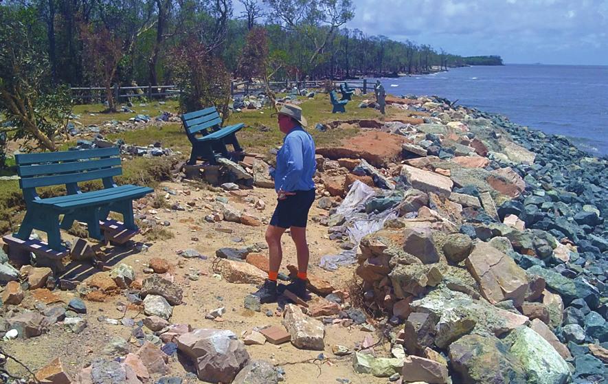
Tropical Cyclone Oswald Coastal Monitoring
 Tropical Cyclone Oswald Coastal Monitoring Kieran Harper and John Maher Coastal Impacts Unit, Queensland Department of Science, Information Technology, Innovation and the Arts (DSITIA). 27 Quinlan St Deagon,
EMERGENCY PREPAREDNESS PLAN
 EMERGENCY PREPAREDNESS PLAN CONTENTS OVERVIEW WILDFIRE EARTHQUAKE HURRICANE FLOOD TORNADO 2 3 5 7 8 10 BE PREPARED. OVERVIEW No matter the type of weather emergency, you should make a family communication
Hurricanes: Nature's Wildest Storms
 Name: Hurricanes: Nature's Wildest Storms by Erin Ryan You may already know that hurricanes are major tropical storms that can cause devastating waves, wind, and rain. They happen during Hurricane Season,
Preparedness Safety Tips
 Preparedness Safety Tips Timely preparation can avert heavy personal, business and government expenditures. Experts agree that the following measures can be effective in dealing with the challenges of
DRAFT - Tsunami Response Plan Playbook Santa Cruz Harbor Maritime Community
 DRAFT - Tsunami Response Plan Playbook Santa Cruz Harbor Maritime Community Page 1 Best to display on 11X17 paper Purpose and Use of this Real-time Tsunami Response Plan Playbook PURPOSE: This product
Bayview Marina. Cyclone Response Plan
 Bayview Marina Cyclone Response Plan November 2015 1 Cyclone Emergency Response Plan Purpose Being prepared to handle an event be it Cyclonic, Marine Accident or Oil Spill is the major factor in ensuring
Disaster Timeline Messages
 Disaster Timeline Messages Each disaster is unique and messaging should reflect the specific circumstances of the incident. The grid below can help guide key messages before, during and after disasters.
ALL TENANTS BRENNER REAL ESTATE GROUP
 TO: FROM: ALL TENANTS BRENNER REAL ESTATE GROUP RE: EMERGENCY NATURAL DISASTER PROCEDURES & PREP Brenner Real Estate Group, in an effort to better prepare it s properties and tenants, has compiled this
The Philippines modified its Tropical Cyclone Warning System
 The Philippines modified its Tropical Cyclone Warning System Historical Background As an archipelago in Western North Pacific, the Philippines is exposed to tropical cyclones of varying intensity and impacts
What is a tsunami? Capital Regional District Tsunami Frequently Asked Questions (FAQ s) Tsunami (soo-nah-mee)
 Tsunami (soo-nah-mee)") Tsunami (soo-nah-mee) Tsunamis (Japanese translation harbour wave ) are waves with a great distance between crests, and are caused by any widespread, sudden movement of large volumes of water. The tsunami
Tsunami (soo-nah-mee) Tsunamis (Japanese translation harbour wave ) are waves with a great distance between crests, and are caused by any widespread, sudden movement of large volumes of water. The tsunami
Analysis of fatalities attributed to Hurricane Florence in the US.
 Analysis of fatalities attributed to Hurricane Florence in the US. Jonathan van Leeuwen Hurricane Florence impacted the US East Coast in September 2018 resulting in dangerous surf conditions, strong winds,
PLANNING FOR HURRICANE AND TROPICAL STORMS FOR THE DIOCESE OF CORPUS CHRISTI
 PLANNING FOR HURRICANE AND TROPICAL STORMS FOR THE DIOCESE OF CORPUS CHRISTI SECTION ONE Hurricanes and Tropical Storms SECTION KEY Disaster Definitions Planning for a Hurricane Levels of Activation Checklists
Disclaimer. This report was compiled by an ADRC visiting researcher (VR) from ADRC member countries.
 from ADRC member countries.") Disclaimer This report was compiled by an ADRC visiting researcher (VR) from ADRC member countries. The views expressed in the report do not necessarily reflect the views of the ADRC. The boundaries and
Disclaimer This report was compiled by an ADRC visiting researcher (VR) from ADRC member countries. The views expressed in the report do not necessarily reflect the views of the ADRC. The boundaries and
Severe storm lesson plan
 Severe storm lesson plan The severe storm lesson plan provides teachers and students with an opportunity to investigate how storms occur and how to stay safe during a storm through individual or classroom
TORNADO SAFETY From the Michigan Committee on Severe Weather Awareness
 Tornado Terminology Tornadoes can happen abruptly, especially during Michigan s late spring and early summer seasons. Learn the terms to understand and know what do before, during and after a tornado.
Hurricane Basics and Preparedness. Jim Weyman Director, Central Pacific Hurricane Center Phone Office:
 Hurricane Basics and Preparedness Jim Weyman Director, Central Pacific Hurricane Center Phone Office: 973-5270 james.weyman@noaa.gov United States Hurricane/Typhoon Centers National Hurricane Center, Miami
Tornado Safety: 2013 Practical Steps for Weather-Related Emergencies
 Tornado Safety: 2013 Practical Steps for Weather-Related Emergencies Campbell County Public Safety One County, One Mission, One Call Away Tornado Preparedness Day March 12, 2013 As 62 tornadoes struck
Hurricanes form over warm ocean water.
 KEY CONCEPT Low-pressure systems can become storms. BEFORE, you learned Moving air masses cause changes in weather A low-pressure system brings stormy weather NOW, you will learn How hurricanes develop
Meeting the New Queensland Coastal Plan Storm Surge Requirements for Redland City Council. Queensland Coastal Conference 2011
 Meeting the New Queensland Coastal Plan Storm Surge Requirements for Redland City Council Ancient Knowledge Contemporary Innovation The Pullman Reef Hotel, Cairns Daniel Niven 1 and David Taylor 2 1 Cardno
Very Dangerous Coastal Storm Sandy October 28 th 31 st 2012
 Very Dangerous Coastal Storm Sandy October 28 th 31 st 2012 Prepared 600 PM EDT Monday October 29, 2012 Gary Szatkowski NOAA s NJ Forecast Office Weather.gov/phi Purpose of Briefing Briefing #11 for event
TSUNAMI EVACUATION ROUTE
 TSUNAMI EVACUATION ROUTE for the Eastern Bay of Plenty Contents What is a tsunami? 3 How will I know if a tsunami has been generated? 3 How will I know when to evacuate? 4 What can I do to protect myself
COMMUNITY EMERGENCY RESPONSE TEAM FLOODS INTRODUCTION
 INTRODUCTION Floods are one of the most common hazards in the United States. A flood occurs any time a body of water rises to cover what is usually dry land. Flood effects can be local, impacting a neighborhood
What's ACTIVITY BOOK. the Plan Stan?
 What's ACTIVITY BOOK the Plan Stan? What's the Plan Stan? THIS BOOKLET BELONGS TO: ACTIVITY AND COLOURING BOOKLET Meet the Impact Team Moana Can't get home Moana is ready to gather everyone together. She's