April 16, Tornado Damage Survey
|
|
|
- Lionel Shaw
- 5 years ago
- Views:
Transcription

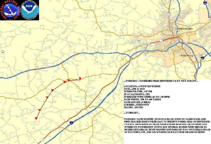
1 April 16, Tornado Damage Survey Below is information on the storm damage surveys conducted by the National Weather Service in Wakefield, VA. Appreciation is extended to county officials and property owners who allowed us onto their properties to document and photograph the damage they experienced. Confirmed Tornadoes: EF:1 Dinwidde County, VA, EF:3-Bertie County, NC, EF-2 Isle of Wight, EF-1 Currituck County, NC, EF-3 Gloucester County[storm track includes Surry Co, crosses James&York Rivers and ends Mathews County], EF-2 Middlesex County, EF-1 Western Middlesex, EF-1 Lunenburg County VA, EF-1 Southampton County VA, EF-1 Northampton County, NC, EF-1 Southampton County, VA Tornado #1- Dinwiddie County, VA
2

3

4 Picture 1- WWBT-TV Tornado #2 & #3 - Bertie County, NC

5
6 Tornado #2...BERTIE COUNTY NC TORNADO SURVEY RESULTS... LOCATION...1 MILE SOUTH OF ASKEWVILLE NC NORTHEAST TO ABOUT 3 MILES EAST OF HARRELLSVILLE DATE...APRIL ESTIMATED TIME PM EF-SCALE RATING...EF3 /PRELIMINARY...PENDING FURTHER ANALYSIS/ ESTIMATED WIND SPEED TO 165 MPH PATH WIDTH...1/2 TO 3/4 MILE PATH LENGTH MILES INJURIES...50 /ESTIMATED/ DEATHS...12 /CONFIRMED/...SUMMARY... TORNADO FIRST TOUCHED DOWN ABOUT 1 MILE SOUTH OF ASKEWVILLE NC...DOING MINOR TREE AND BUILDING DAMAGE. THE TORNADO THEN TRACKED CONTINUOUSLY FOR NEARLY 19 MILES...FINALLY LIFTING EAST OF HARRELLSVILLE. FOR MUCH OF THE TORNADO`S LIFE...THE PATH WIDTH WAS ONE HALF TO NEARLY 3/4 MILES WIDE. EF2 AND EF3 DAMAGE WAS WIDESPREAD FROM JUST WEST OF ASKEWVILLE...NORTHEAST TO JUST WEST OF COLERAIN...THEN GRADUALLY DECREASING AS THE TORNADO CROSSED INTO HERTFORD COUNTY. NUMEROUS HOMES WERE DESTROYED...AND MANY OTHERS SUFFERED VARYING DEGREES OF DAMAGE. IN ADDITION...THERE WAS EXTENSIVE DAMAGE TO TREES AND WOODED AREAS IN THE PATH OF THE TORNADO. A SPLIT IN THE TORNADO DAMAGE PATHS JUST NORTH OF COLERAIN SUGGESTS THAT THE TORNADO UNDERWENT A CYCLIC RE-DEVELOPMENT...WITH 2 TORNADOES ON THE GROUND SIMULTANEOUSLY FOR A PERIOD OF ABOUT 5 MILES. THE SECOND TORNADO...WITH A DAMAGE PATH JUST TO THE EAST OF THE ORIGINAL...STRONGER TORNADO...IS DETAILED BELOW. && Tornado # 3 LOCATION...1 MILE NW OF COLERAIN NORTHEAST TO ABOUT 4 MILES EAST OF
7 HARRELLSVILLE DATE...APRIL ESTIMATED TIME PM EF-SCALE RATING...EF2 ESTIMATED WIND SPEED TO 135 MPH PATH WIDTH TO 500 YARDS PATH LENGTH MILES INJURIES...UNKNOWN DEATHS...NONE...SUMMARY... A DISTINCT SEPARATION IN THE DAMAGE PATHS NW OF COLERAIN SUGGESTS THAT A SECOND TORNADO FORMED JUST NW OF COLERAIN...AND TRACKED NORTHEAST NEARLY PARALLEL TO THE ORIGINAL TORNADO. NORTH OF COLERAIN...THE TORNADO TRACKED PARALLEL RT. 45 FOR ABOUT 1 MILE...THEN CONTINUED NORTHEAST IN SOUTHEAST HERTFORD COUNTY...JUST WEST OF THE CHOWAN RIVER. THE TORNADO CROSSED THE CHOWAN RIVER WHILE CONTINUING TO WEAKEN. THE FINAL VERY MINOR DAMAGE WAS NOTED A COUPLE MILES NORTHEAST OF HOBBSVILLE TO THE WEST OF ROUTE 32. IN THE BERTIE COUNTY PORTION OF THE SECOND TORNADO...SEVERAL HOMES AND OTHER BUILDINGS WERE DAMAGED. POULTRY HOUSES AND OTHER FARM EQUIPMENT WERE ALSO DAMAGED. MANY TREES DOWN OR SNAPPED OFF. MOST OF THE DAMAGE IN GATES COUNTY WAS TO TREES. NUMEROUS TREES WERE DOWNED...WITH MANY OTHERS SNAPPED AT THE TOP. A MOBILE HOME ROOF WAS BLOWN OFF...AND THERE WAS MINOR DAMAGE TO SOME FARM EQUIPMENT...AND A COUPLE OTHER HOMES. THE DAMAGE IN GATES COUNTY WAS EF0 AND EF1...WITH THE SEVERITY OF THE DAMAGE DECREASING AS THE TORNADO MOVED NORTHEAST. Bertie County, NC Tornado Pictures - Taken by NWS Wakefield, VA


8 This is the view from KAKQ Radar at 6:57pm EDT The corresponding 6:57 EDT SRM Imagery from KAKQ Radar (Wakefield)

9
10 Tornado #4 Isle of Wight County, VA 0727 PM 04/16/2011 TORNADO 1 SW ISLE OF WIGHT ISLE OF WIGHT VA 36.90N 76.72W NWS STORM SURVEY NWS STORM SURVEY DETERMINED DAMAGE CONSISTENT WITH AN EF-2 TORNADO IN ISLE OF WIGHT COUNTY. THE TORNADO DAMAGE WAS ALONG A NEARLY CONTINUOUS 20 MILE DAMAGE PATH FROM EAST OF WALTERS TO JUST SOUTHWEST OF SMITHFIELD. MANY TREES WERE DOWNED...SHEARED OFF OR TOPPED. MORE THAN 2 DOZEN HOMES WERE DAMAGED...A FEW SUSTAINING SIGNIFICANT DAMAGE. SEVERAL FARMS WERE IMPACTED...WITH FARM EQUIPMENT PICKED UP AND TOSSED AROUND. photo by Aaron Graham Tornado #5 Currituck County, NC...TORNADO CONFIRMED IN SOUTHERN CURRITUCK COUNTY... LOCATION...NEAR HARBINGER DATE...APR ESTIMATED TIME PM EF-SCALE RATING...EF1
11 ESTIMATED WIND SPEED...86 TO 110 MPH PATH WIDTH TO 200 YARDS PATH LENGTH MILES INJURIES...NONE DEATHS...NONE...SUMMARY... TORNADO APPARENTLY MOVED INLAND OFF THE ALBEMARLE SOUND AND CONTINUED EAST-NORTHEAST ACROSS RT AND THEN TOWARD CURRITUCK SOUND. NUMEROUS TREES DOWN OR SNAPPED OFF. DAMAGE TO SEVERAL COMMERCIAL BUILDINGS AND A FEW HOMES. VEHICLES WERE OVERTURNED...AND SEVERAL BOATS WERE LIFTED ACROSS RT. 158.

12
13 Tornado #6 Surry County to Mathews County...including Gloucester County, VA

14
15 photos above by VA State Police Download Google Earth kmz file of tornado track here...surry JAMES CITY YORK GLOUCESTER AND MATHEWS COUNTIES SURVEY RESULTS... LOCATION...FROM JUST SOUTH OF THE SURRY NUCLEAR POWER PLANT TO NORTHEAST OF ROUTE 14 IN MATHEWS COUNTY DATE...APR ESTIMATED TIME PM TO 720 PM EF-SCALE RATING...EF3 /PRELIMINARY...PENDING FURTHER ANALYSIS... ESTIMATED WIND SPEED TO 165 MPH PATH WIDTH...FROM 200 YARDS TO A HALF MILE PATH LENGTH...APPROX. 30 MILES INJURIES...24 DEATHS SUMMARY... NWS STORM SURVEY DETERMINED THE DAMAGE WAS CONSISTENT WITH AN EF3 TORNADO. THE TORNADO DEVELOPED JUST SOUTH OF THE SURRY NUCLEAR POWER PLANT AND THEN CONTINUED ACROSS THE JAMES RIVER AND THROUGH THE KINGSMILL SECTION OF JAMES CITY COUNTY. THE TORNADO THEN MOVED NORTHEAST ACROSS THE YORK RIVER INTO SOUTHERN GLOUCESTER COUNTY. THE WORST DAMAGE CONSISTENT WITH AN EF3 RATING WAS NEAR CLOPTON IN GLOUCESTER COUNTY. THE TORNADO THEN EVENTUALLY LIFTED IN SOUTHWESTERN MATHEWS COUNTY. THE TORNADO HAD A NEARLY CONTINUOUS DAMAGE PATH RANGING IN WIDTH FROM AROUND 200 YARDS TO AS MUCH AS A HALF MILE WIDE IN GLOUCESTER COUNTY. OVER 200 HOMES WERE DAMAGED WITH MANY OF THESE HOMES SEVERELY DAMAGED. NUMEROUS TREES WERE DOWNED OR SHEARED OFF. Pictures - Taken by NWS Wakefield, VA
16 Tornado #7 Middlesex County, VA

17
18 ...MIDDLESEX COUNTY SURVEY RESULTS... LOCATION...FROM FISHING BAY SOUTH OF DELTAVILLE TO THE RAPPAHANNOCK RIVER DATE...APR ESTIMATED TIME PM TO 740 PM EF-SCALE RATING...EF2 ESTIMATED WIND SPEED TO 135 MPH PATH WIDTH...A QUARTER MILE PATH LENGTH...3 MILES INJURIES...0 DEATHS SUMMARY... NWS STORM SURVEY DETERMINED THE DAMAGE WAS CONSISTENT WITH AN EF2 TORNADO. THE TORNADO DEVELOPED IN SOUTHEASTERN MIDDLESEX COUNTY ALONG THE PLANKATANK RIVER MOVING NORTHEAST THROUGH DELTAVILLE THEN OFF THE LAND AND DISSIPATING OVER THE RAPPAHANNOCK RIVER. 95 HOMES WERE DAMAGED IN DELTAVILLE WITH MANY BEING SEVERELY DAMAGED. NUMEROUS TREES WERE DOWNED AND MANY SHEARED OFF. THE TORNADO HAD A PATH WIDTH AROUND A QUARTER MILE ALONG ITS CONTINUOUS DAMAGE PATH. Tornado #8 Western Middlesex County, VA

19
20 Above image is interpretation based on report below. It is NOT tornado track but area of damage....western MIDDLESEX COUNTY SURVEY RESULTS... LOCATION...CORBIN HALL FARM TO WARNER ROAD DATE...APR ESTIMATED TIME PM TO 635 PM EF-SCALE RATING...EF1 ESTIMATED WIND SPEED...86 TO 110 MPH PATH WIDTH...A QUARTER MILE PATH LENGTH...2 MILES INJURIES...0 DEATHS SUMMARY... NWS STORM SURVEY DETERMINED THE DAMAGE WAS CONSISTENT WITH AN EF1 TORNADO. THE TORNADO TRACKED FROM LAGRANGE CREEK TO FAMILY LANE. THIS TORNADO DESTROYED 1 HOME HOME AND A GRAIN SILO. NUMEROUS TREES WERE DOWNED AND SHEARED OFF. THE TORNADO HAD A PATH WIDTH AROUND A QUARTER MILE AND MAY HAVE HAD MULTIPLE VORTEXES IN THE MAIN FUNNEL. Tornado #9 Lunenburg County, VA

21
22 ...LUNENBURG COUNTY TORNADO SURVEY RESULTS... LOCATION...ROCKY MILL RD TO JUST SOUTH OF THE FALLS DATE...APR ESTIMATED TIME PM TO 400 PM EF-SCALE RATING...EF1 ESTIMATED WIND SPEED...86 TO 110 MPH PATH WIDTH TO 300 YARDS WIDE PATH LENGTH MILES INJURIES...0 DEATHS SUMMARY... TORNADO DAMAGE WAS FIRST NOTED IN SOUTHWEST LUNENBURG COUNTY...NEAR THE MECKLENBURG COUNTY LINE...ON ROCKY MILL RD. THE TORNADO CONTINUED NORTHEAST TO THE EAST OF RT. 49 FOR ABOUT 17 MILES...BEFORE LIFTING NEAR THE LUNENBURG/NOTTOWAY COUNTY LINE NEAR THE FALLS. MOST OF THE DAMAGE WAS TO TREES...WITH NUMEROUS TREES DOWN OR SHEARED OFF. A FEW HOMES WERE DAMAGED...AS WERE A NUMBER OF SHEDS AND OUTBUILDINGS. THE MOST INTENSE DAMAGE WAS NOTED IN VICINITY OF REHOBETH ROAD...SOUTHEAST OF REHOBETH. THE TORNADO THEN CONTINUED NORTHEAST ACROSS THE EAST AND NORTH SIDES OF VICTORIA. DAMAGE TO TREES AND OUTBUILDINGS WAS NOTED AT VICTORIA GOLF CLUB. Tornado #10 Southampton County, VA

23
24 ...SOUTHAMPTON COUNTY VA TORNADO SURVEY RESULTS... LOCATION...SOUTH OF RT. 58 BETWEEN STATE ROUTE 659 AND 3 CREEKS RD. DATE...APR ESTIMATED TIME PM EF-SCALE RATING...EF1 ESTIMATED WIND SPEED...86 TO 110 MPH PATH WIDTH TO 300 YARDS WIDE PATH LENGTH MILES INJURIES...0 DEATHS SUMMARY... STORM SURVEY CONDUCTED THIS AFTERNOON SHOWED THAT A BRIEF TORNADO TOUCHED DOWN IN SOUTHWEST SOUTHAMPTON COUNTY...PRODUCING EF0 AND WEAK EF1 DAMAGE. NUMEROUS TREES WERE SNAPPED OFF...AND A FEW STRUCTURES SUSTAINED DAMAGE. THE MOST SIGNIFICANT DAMAGE WAS TO A FARM EQUIPMENT SHELTER AND A ROOF ON A HOME. Tornado #11 Northampton County, NC

25
26 ...NORTHAMPTON COUNTY NC TORNADO SURVEY RESULTS... LOCATION...JUST SOUTH OF ROANOKE RAPIDS TO JUST NORTH OF THE INTERSECTION OF I-95 AND RT. 46 DATE...APR ESTIMATED TIME PM EF-SCALE RATING...EF1 ESTIMATED WIND SPEED...86 TO 110 MPH PATH WIDTH TO 300 YARDS WIDE PATH LENGTH MILES INJURIES...0 DEATHS SUMMARY... STORM SURVEY CONDUCTED BY WFO RALEIGH INDICATED THAT A TORNADO...WHICH ORIGINALLY TOUCHED DOWN JUST SOUTH OF ROANOKE RAPIDS...MOVED NORTHEAST INTO NORTHAMPTON COUNTY. THE TORNADO PRODUCED EF1 DAMAGE...WITH A NUMBER OF TREES SNAPPED...AND SOME ROOF DAMAGE TO A HOME. THE TORNADO LIFTED JUST NORTH OF THE I-95 TO RT. 46 INTERSECTION. Tornado #12 Southampton County, VA
27
28
...TORNADO CONFIRMED NEAR SANFORD...BROADWAY...HOLLY SPRINGS AND RALEIGH IN LEE AND WAKE COUNTIES COUNTY NORTH CAROLINA...
 ...TORNADO CONFIRMED NEAR SANFORD...BROADWAY...HOLLY SPRINGS AND RALEIGH IN LEE AND WAKE COUNTIES COUNTY NORTH CAROLINA... LOCATION...SANFORD...BROADWAY...HOLLY SPRINGS AND RALEIGH IN LEE AND WAKE COUNTIES
PUBLIC INFORMATION STATEMENT...UPDATED FATALITY INFO NATIONAL WEATHER SERVICE RALEIGH NC 435 PM EDT MON APR
 PUBLIC INFORMATION STATEMENT...UPDATED FATALITY INFO NATIONAL WEATHER SERVICE RALEIGH NC 435 PM EDT MON APR 18 2011...MULTIPLE TORNADOES CONFIRMED ON APRIL 16 2011......TORNADO CONFIRMED NEAR WAYSIDE TO
...TORNADO CONFIRMED NEAR SANFORD...BROADWAY...HOLLY SPRINGS AND RALEIGH IN LEE AND WAKE COUNTIES COUNTY NORTH CAROLINA...
 ...TORNADO CONFIRMED NEAR SANFORD...BROADWAY...HOLLY SPRINGS AND RALEIGH IN LEE AND WAKE COUNTIES COUNTY NORTH CAROLINA... LOCATION...SANFORD...BROADWAY...HOLLY SPRINGS AND RALEIGH IN LEE AND WAKE COUNTIES
Wyoming State Operations Center
 Wyoming State Operations Center Updated Situation Report, Bordeaux Tornado site 14: 36 hrs 8 June 2012 Wyoming Office of Homeland Security (WOHS) arrived at the incident command post at the corner of Olson
Tuesday marks 20th anniversary of SE VA tornado outbreak
 Tuesday marks 20th anniversary of SE VA tornado outbreak Posted on: 2:28 pm, August 5, 2013, by Becca Mitchell On August 6, 1993, an outbreak of 18 tornadoes struck southeastern Virginia. This was the
National Weather Service Des Moines Storm Storm Survey Bradgate and Rolfe Tornadoes of May 22, 2004
 National Weather Service Des Moines Storm Storm Survey Bradgate and Rolfe Tornadoes of May 22, 2004 Brenda Brock, MIC Jeff Johnson, WCM Shane Searcy, ITO Chuck Myers, Senior Forecaster Eric Lenning, ITO
June 17, 2010: Historic Tornado Outbreak Across Minnesota
 June 17, 2010: Historic Tornado Outbreak Across Minnesota The Chanhassen warning and forecast area covers 42 Minnesota counties, and on June 17 there were 25 tornadoes across those 42 counties. There were
The Severe Weather Event of 7 August 2013 By Richard H. Grumm and Bruce Budd National Weather Service State College, PA 1. INTRODUCTION and Overview
 The Severe Weather Event of 7 August 2013 By Richard H. Grumm and Bruce Budd National Weather Service State College, PA 1. INTRODUCTION and Overview A fast moving short-wave (Fig. 1) with -1σ 500 hpa height
GC Briefing. Weather Sentinel Hurricane Florence. Status at 5 PM EDT (21 UTC) Today (NHC) Discussion. September 13, 2018
 Today (NHC) Discussion. September 13, 2018") GC Briefing September 13, 2018 Weather Sentinel Hurricane Florence Tropical storm conditions have been reported for areas of North Carolina and will continue to spread inland to the west and south. Hurricane
GC Briefing September 13, 2018 Weather Sentinel Hurricane Florence Tropical storm conditions have been reported for areas of North Carolina and will continue to spread inland to the west and south. Hurricane
DAMAGE SURVEY OF THE BINGER, OKLAHOMA TORNADO OF MAY 22, 1981
 DAMAGE SURVEY OF THE BINGER, OKLAHOMA TORNADO OF MAY 22, 1981 1. INTRODUCTION James R. McDonald, H. Scott Norville, and Timothy P. Marshall Institute for Disaster Research Texas Tech University Lubbock,
CHAPTER 10. TORNADOES AND WINDSTORMS
 CHAPTER 10. TORNADOES AND WINDSTORMS Wyoming, lying just west of tornado alley, is fortunate to experience less frequent and intense tornadoes than its neighboring states to the east. However, tornadoes
Tornadoes. Be able to define what a tornado is. Be able to list several facts about tornadoes.
 Tornadoes Be able to define what a tornado is. Be able to list several facts about tornadoes. 1. Where do tornadoes most U.S. is # 1 occur in the world? Tornadoes are most common in Tornado Alley. Tornado
IN VEHICLES: Do not try to outrun a tornado. Abandon your vehicle and hide in a nearby ditch or depression and cover your head.
 TORNADO SAFETY TORNADO! The very word strikes fear in many people. While a tornado is perhaps nature's most destructive storm, deaths and injuries can be prevented. By following Tornado Safety Rules, lives
1st Tornado Photograph
 Lecture 26 Part II Tornados Environment Storm Structure Life Cycle Source of Spin Forecasting Climatology Damage Marilee Thomas of Beaver City, NE took this photograph of her daughter Audra about two miles
1993 California Wildfires - Fall Dry weather, high winds and wildfires in Southern CA; approximately $1.0 (1.3) billion damage/costs; 4 deaths.
 billion damage/costs; 4 deaths.") 1993 California Wildfires - Fall 1993. Dry weather, high winds and wildfires in Southern CA; approximately $1.0 (1.3) billion damage/costs; 4 deaths. A Day of Wildfire - October 28, 1993 Wednesday's disastrous
1993 California Wildfires - Fall 1993. Dry weather, high winds and wildfires in Southern CA; approximately $1.0 (1.3) billion damage/costs; 4 deaths. A Day of Wildfire - October 28, 1993 Wednesday's disastrous
Tropical Update. 11 AM EDT Wednesday, October 10, 2018 Hurricane Michael, Hurricane Leslie & Tropical Storm Nadine, Caribbean Low (40%)
") Tropical Update 11 AM EDT Wednesday, October 10, 2018 Hurricane Michael, Hurricane Leslie & Tropical Storm Nadine, Caribbean Low (40%) This update is intended for government and emergency response officials,
Tropical Update 11 AM EDT Wednesday, October 10, 2018 Hurricane Michael, Hurricane Leslie & Tropical Storm Nadine, Caribbean Low (40%) This update is intended for government and emergency response officials,
Severe Weather: Tornadoes and Hurricanes
 Severe Weather: Tornadoes and Hurricanes Tornadoes Grab Toto!! TORNADOES Are a low pressure storm that usually forms over land in an average year, 800 tornadoes are reported in the U.S. a tornado is defined
GC Briefing. Weather Sentinel Tropical Storm Michael. Status at 8 AM EDT (12 UTC) Today (NHC) Discussion. October 11, 2018
 Today (NHC) Discussion. October 11, 2018") GC Briefing Weather Sentinel Tropical Storm Michael October 11, 2018 After making landfall as a high-end category-4 hurricane on the Florida Panhandle, Michael weakened to tropical storm status early this
GC Briefing Weather Sentinel Tropical Storm Michael October 11, 2018 After making landfall as a high-end category-4 hurricane on the Florida Panhandle, Michael weakened to tropical storm status early this
Hurricane Matthew Threats and Impacts Briefing for Eastern NC
 Hurricane Matthew Threats and Impacts Briefing for Eastern NC October 6 th, 2016 Date/Time Created: 10/6/2016, Noon EDT National Weather Service Newport/Morehead City, NC Hurricane Matthew Key Points Changes
Major Hurricane Earl
 Major Hurricane Earl Advisory 32 North Carolina Threat Assessment Prepared at: 8 AM Thursday September 2, 2010 Hurricane and Tropical Storm Warnings in effect for the North Carolina Coast and Sounds. NWS
Tropical Storm Ana. Created 615 AM Sat May 9, 2015 Reid Hawkins, Science Officer
 Tropical Storm Ana Threat Assessment for northeast South Carolina & southeast North Carolina Created 615 AM Sat May 9, 2015 Reid Hawkins, Science Officer National Weather Service Wilmington, NC 1 New Information
Wind field has expanded and is very large. Hurricane Wind field = 100 miles wide, Tropical Storm Wind field = 360 miles wide
 HURRICANE IRMA 12 PM ET Sunday, September 10 2017 Prepared by: Keith Stellman / Kyle Thiem www.weather.gov/atlanta/briefings @NWSAtlanta www.weather.gov/atlanta Situation Overview 11:10 AM EDT Sun Sep
Mid Atlantic Severe Event of 1 May 2017 Central Pennsylvania QLCS event By Richard H. Grumm National Weather Service, State College, PA 16803
 1. Overview Mid Atlantic Severe Event of 1 May 2017 Central Pennsylvania QLCS event By Richard H. Grumm National Weather Service, State College, PA 16803 A strong upper-level wave (Fig.1) moving into a
National Weather Service
 National Weather Service Integrated Warning Team Workshops: NWS Warnings and Outdoor Warning Sirens Tim Halbach Warning Coordination Meteorologist Milwaukee NWS Integrated Warning Team NWS State Officials
Tornadoes. Tornadoes are an interesting topic because as often as they occur in the United
 John Bucaro Environmental Hazards Dr. Scott 9/17/03 Tornadoes Tornadoes are an interesting topic because as often as they occur in the United States scientists still do not know much about them. They occur
CASE STUDY: Severe Thunder Storms and Bucca Tornado, 29 th November 1992
 CASE STUDY: Severe Thunder Storms and Bucca Tornado, 29 th November 1992 By Mr Jeff Callaghan Retired Senior Severe Weather Forecaster, Bureau of Meteorology, Brisbane This was a notable severe thunderstorm
Tropical Storm Colin Briefing Last Briefing on this System
 Tropical Storm Colin Briefing Last Briefing on this System NWS WFO Jacksonville, Florida Tuesday, June 07, 2016 6:00 a.m. EDT Tropical Storm Colin s Impacts SE Georgia & North Florida Local Watches & Warnings:
Major Hurricane Earl
 Major Hurricane Earl Advisory 33 North Carolina Threat Assessment Prepared at: 11 AM Thursday September 2, 2010 Hurricane and Tropical Storm Warnings in effect for the North Carolina Coast and Sounds NWS
HURRICANE IRMA. 12 PM ET Saturday, September Prepared by: Kyle Thiem / Sid King.
 HURRICANE IRMA 12 PM ET Saturday, September 9 2017 Prepared by: Kyle Thiem / Sid King www.weather.gov/atlanta/briefings @NWSAtlanta www.weather.gov/atlanta Situation Overview 11:00 AM EDT Sat Sep 9 Location:
August 2006 Summary. August 1-5
 Ashley Brooks (765) 494-6574 Sep 8, 2006 http://www.iclimate.org August 1-5 August 2006 Summary The heat wave that started during the end of July continued into the beginning parts of August with temperatures
SIGNIFICANT EVENTS Severe Storms November 1994 January 1996 August 1998 and May 2000 March 2002 May 2002 Champaign County
 SIGNIFICANT EVENTS Severe Storms November 1994 On Nov. 1, 1994, high winds gusted over 60 mph at times across the northwest third of Ohio. The highest measured wind gust was 63 mph at Columbus Grove (Putnam).
3 Severe Weather. Critical Thinking
 CHAPTER 2 3 Severe Weather SECTION Understanding Weather BEFORE YOU READ After you read this section, you should be able to answer these questions: What are some types of severe weather? How can you stay
Welcome Jeff Orrock Warning Coordination Meteorologist National Weather Service Raleigh
 Welcome Jeff Orrock Warning Coordination Meteorologist National Weather Service Raleigh Jeff.orrock@noaa.gov Sources: Operational Significant Event Imagery and the Environmental Applications Team (EAT)
Tropical Storm Ana. Created 6:00 AM Sun May 10, 2015 John Cole Warning Coordination Meteorologist
 Tropical Storm Ana Threat Assessment for Eastern North Carolina Created 6:00 AM Sun May 10, 2015 John Cole Warning Coordination Meteorologist John.cole@noaa.gov National Weather Service Newport/Morehead
2011 Year in Review TORNADOES
 2011 Year in Review The year 2011 had weather events that will be remembered for a long time. Two significant tornado outbreaks in April, widespread damage and power outages from Hurricane Irene in August
Your Task: Read each slide then use the underlined red or underlined information to fill in your organizer.
 Severe Weather: Tornadoes and Hurricanes Thunderstorms and Lightning S6E4 d. Construct an explanation of the relationship between air pressure, weather fronts, and air masses and meteorological events
Comparison of November 15, 2008 Killer Tornado Outbreak with the December 2, 2009 Non Tornado Event
 Comparison of November 15, 2008 Killer Tornado Outbreak with the December 2, 2009 Non Tornado Event The two events featured similar patterns but with much different results in central NC. The slides on
3A.6 ANALYSIS OF DATA FROM THE 2008 SUPER TUESDAY SEVERE WEATHER OUTBREAK: AN ARKANSAS PERSPECTIVE
 3A.6 ANALYSIS OF DATA FROM THE 2008 SUPER TUESDAY SEVERE WEATHER OUTBREAK: AN ARKANSAS PERSPECTIVE Christopher C. Buonanno* John A. Lewis III NOAA/NWS Little Rock AR 1. INTRODUCTION The Super Tuesday Severe
VORTEX-2: SUNY Oswego Soundings Team Significant Observed Weather Events Kevin M. Smith
 VORTEX-2: SUNY Oswego Soundings Team Significant Observed Weather Events Kevin M. Smith Summary Last Updated: Final Update The following is a chronological listing of significant weather conditions observed
Tornado Damage in Happy, Texas, May 5, 2002
 Tornado Damage in Happy, Texas, May 5, 2002 A report prepared by Larry J. Tanner, P.E. Submitted to NIST August 19, 2002 Wind Science and Engineering Research Center Texas Tech University Lubbock, Texas
Hurricane Matthew. Life Threatening Flash Flooding Likely. National Weather Service Wilmington NC. Josh Weiss, Meteorologist
 Hurricane Matthew Life Threatening Flash Flooding Likely Threat Assessment for northeast South Carolina & southeast North Carolina National Weather Service Wilmington NC 630 PM EDT Friday October 7, 2016
WEATHER SYSTEMS IMPACTING THE CAYMAN ISLANDS Prepared by the staff of the Cayman Islands National Weather Service
 WEATHER SYSTEMS IMPACTING THE CAYMAN ISLANDS 2008 Prepared by the staff of the Cayman Islands National Weather Service TROPICAL STORM DOLLY Formed 194 miles west of Grand Cayman July 19 th. The tropical
While all thunderstorms are dangerous, the National Weather Service (NWS) defines a severe thunderstorm as one that:
 defines a severe thunderstorm as one that:") While all thunderstorms are dangerous, the National Weather Service (NWS) defines a severe thunderstorm as one that: Produces hail at least three-quarters of an inch in diameter. Has winds of 58 miles
While all thunderstorms are dangerous, the National Weather Service (NWS) defines a severe thunderstorm as one that: Produces hail at least three-quarters of an inch in diameter. Has winds of 58 miles
P10.2 SUBTLE RADAR SIGNATURES IN THE WEST BROOKFIELD, MA TORNADO OF 23 JULY 2002
 P10.2 SUBTLE RADAR SIGNATURES IN THE WEST BROOKFIELD, MA TORNADO OF 23 JULY 2002 Glenn A. Field and David R. Vallee NOAA/National Weather Service Forecast Office, Taunton, MA 1. INTRODUCTION Tornadic storms
Tropical Update. 5 PM EDT Tuesday, September 5, 2017 Hurricane Irma, Tropical Storm Jose, and Tropical Depression Thirteen
 Tropical Update 5 PM EDT Tuesday, September 5, 2017 Hurricane Irma, Tropical Storm Jose, and Tropical Depression Thirteen This update is intended for government and emergency response officials, and is
CHASING TORNADOES by Tim Marshall (published in Weatherwise Magazine, August 1983, photos added)
") CHASING TORNADOES by Tim Marshall (published in Weatherwise Magazine, August 1983, photos added) Tornado is an all-too-familiar word to the folks in West Texas. Each spring, atmospheric conditions favorable
CHASING TORNADOES by Tim Marshall (published in Weatherwise Magazine, August 1983, photos added) Tornado is an all-too-familiar word to the folks in West Texas. Each spring, atmospheric conditions favorable
10 years after Hurricane Charley
 10 years after Hurricane Charley Hurricane Charley (2004) A Retrospective Scott M. Spratt Warning Coordination Meteorologist NWS Melbourne, FL Florida Governors Hurricane Conference May 15, 2014 11 AM
Tropical Update. 5 AM EDT Wednesday, September 6, 2017 Hurricane Irma, Tropical Storm Jose, and Tropical Storm Katia
 Tropical Update 5 AM EDT Wednesday, September 6, 2017 Hurricane Irma, Tropical Storm Jose, and Tropical Storm Katia This update is intended for government and emergency response officials, and is provided
Hydrologic Briefing Tropical Storm Harvey
 Hydrologic Briefing Tropical Storm Harvey 10:30 AM CDT Sunday, August 27, 2017 Prepared by: John Metz NWSCorpus www.weather.gov/corpuschristi Situation Overview Tropical Storm Harvey Harvey to remain a
Hurricane Irma Page 1 HURRTRAK RM/Pro 2017 Summary Report for Tampa, FL 09/10/ EDT, Adv. # 46
 Hurricane Irma Page 1 Description of impact to Tampa, FL, Tampa, FL, is expected to receive a major impact from Hurricane Irma. The forecast maximum wind for this location has increased since the last
Tropical Update. 5 AM EDT Monday, October 8, 2018 Tropical Storm Michael, Tropical Storm Leslie, Invest 92L (10%) & African Tropical Wave (50%)
 & African Tropical Wave (50%)") Tropical Update 5 AM EDT Monday, October 8, 2018 Tropical Storm Michael, Tropical Storm Leslie, Invest 92L (10%) & African Tropical Wave (50%) This update is intended for government and emergency response
Tropical Update 5 AM EDT Monday, October 8, 2018 Tropical Storm Michael, Tropical Storm Leslie, Invest 92L (10%) & African Tropical Wave (50%) This update is intended for government and emergency response
Flood and emergency preparedness CARNATION DUVALL CITIZEN CORPS DUVALL KING COUNTY FIRE DISTRICT 45 SEPTEMBER 11, 2018
 Flood and emergency preparedness CARNATION DUVALL CITIZEN CORPS DUVALL KING COUNTY FIRE DISTRICT 45 SEPTEMBER 11, 2018 Let s get started Important info! Presenters Kathy Brasch, Carnation-Duvall Citizen
Summary of Ohio Tornadoes
 The Ohio State University Knowledge Bank kb.osu.edu Ohio Journal of Science (Ohio Academy of Science) Ohio Journal of Science: Volume 9, Issue (November, 99) 99- Summary of Ohio Tornadoes Miller, Marvin
Hurricane Harvey: SE Texas Impacts. 10 AM CDT UPDATE Saturday, August 26, 2017 Prepared by: Dan Reilly, Brian Kyle
 Hurricane Harvey: SE Texas Impacts 10 AM CDT UPDATE Saturday, August 26, 2017 Prepared by: Dan Reilly, Brian Kyle Latest Observations and Radar Hurricane Harvey centered near Victoria and weakening Wind
The Saffir-Simpson Hurricane Wind Scale
 The Saffir-Simpson Hurricane Wind Scale The Saffir-Simpson Hurricane Wind Scale is a one to five categorization based on the hurricane's intensity at the indicated time. The scale provides examples of
Hydrologic Briefing Tropical Storm Harvey
 Hydrologic Briefing Tropical Storm Harvey 5:00 PM CDT Sunday, August 27, 2017 Prepared by: Jennifer Dunn/Christina Barron NWSCorpus www.weather.gov/corpuschristi Situation Overview Tropical Storm Harvey
FLOOD/SCS EVENT, APRIL 28 MAY 4
 REPORT DATE: May 4, 2017 EVENT DATE: April 28-May 4, 2017 FLOOD/SCS EVENT, APRIL 28 MAY 4 Event Summary General Significant Flood Outlook. SOURCE: National Weather Service. A significant severe thunderstorm
Impact Based Warning Tornado - Infrastructure
 National Weather Service Impact Based Warning Tornado - Infrastructure Jim Kramper Warning Coordination Meteorologist St. Louis, MO NOAA s National Weather Service 2011 was a devastating year for tornado
APPENDIX E. Photographs of Hazard Events in Broome County. DMA 2000 Hazard Mitigation Plan Broome County, New York E-1
 APPENDIX E Photographs of Hazard Events in Broome County DMA 2000 Hazard Mitigation Plan Broome County, New York E-1 Flood of June 2006 (FEMA DR 1650) Sources: Binghamton NWS Forecast Office / Press and
March 2009 Climate Summary
 Joseph Mays (765) 494-6574 Apr 1, 2009 http://www.iclimate.org Summary March 2009 Climate Summary March is in the books and it continued the trend of extreme weather we have experienced during the first
Advisory #35 Briefing 630 PM EDT Thursday October 06, 2016
 Advisory #35 Briefing 630 PM EDT Thursday October 06, 2016 Disclaimer: The information contained within this briefing is time-sensitive, do not use beyond 6 hours after the issuance Next Webinar Update:
Hurricane Wilma Post Storm Data Acquisition Estimated Peak Wind Analysis and Storm Tide Data. December 27, 2005
 Hurricane Wilma Post Storm Data Acquisition Estimated Peak Wind Analysis and Storm Tide Data December 27, 2005 Hurricane Wilma was the sixth major hurricane of the record-breaking 2005 Atlantic hurricane
Mature Tornado. Tornado funnel and debris cloud. Mature Tornado
 Mature Tornado Tornado funnel and debris cloud 43 Mature Tornado 44 Tornado in Final Rope Stage 45 Source of Spin 46 Source of Spin Updraft Stretches Rotating Column 47 Simulation of Tornado Formation
Subtropical Storm Ana
 Subtropical Storm Ana Threat Assessment for northeast South Carolina & southeast North Carolina Created 745 AM Fri May 8, 2015 Reid Hawkins, Science Officer National Weather Service Wilmington, NC 1 New
Tropical Update. 5 PM EDT Thursday, September 7, 2017 Hurricane Irma, Hurricane Jose, and Hurricane Katia
 Tropical Update 5 PM EDT Thursday, September 7, 2017 Hurricane Irma, Hurricane Jose, and Hurricane Katia This update is intended for government and emergency response officials, and is provided for informational
Kentucky Weather Hazards: What is Your Risk?
 Kentucky Weather Hazards: What is Your Risk? Stuart A. Foster State Climatologist for Kentucky 2010 Kentucky Weather Conference Bowling Green, Kentucky January 16, 2010 Perspectives on Kentucky s Climate
Societal impacts of inland moving tropical cyclones across the southeastern U.S
 Societal impacts of inland moving tropical cyclones across the southeastern U.S Maggie M. Kovach, Gretchen Carlson, Charles E. Konrad II NOAA Southeast Regional Climate Center Department of Geography University
Tropical Update. 5 PM EDT Sunday, October 7, 2018 Tropical Storm Michael, Tropical Storm Leslie, & Invest 92L (30%)
") Tropical Update 5 PM EDT Sunday, October 7, 2018 Tropical Storm Michael, Tropical Storm Leslie, & Invest 92L (30%) This update is intended for government and emergency response officials, and is provided
Tropical Update 5 PM EDT Sunday, October 7, 2018 Tropical Storm Michael, Tropical Storm Leslie, & Invest 92L (30%) This update is intended for government and emergency response officials, and is provided
Radar Meteorology AOS 444 October 28, 2002 Laboratory 6: WATADS study of Oakfield tornado from KGRB
 Radar Meteorology AOS 444 October 28, 2002 Laboratory 6: WATADS study of Oakfield tornado from KGRB YOUR NAME: YOUR PARTNER S NAME: On July 18, 1996 the town of Oakfield, Wisconsin was all but destroyed
Flooding and Severe weather of 27 June 2013
 Flooding and Severe weather of 27 June 2013 By Richard H. Grumm National Weather Service State College, PA 1. Overview Flooding and severe weather affected Pennsylvania on 27 June 2013 (Fig 1). The severe
Hurricane Matthew Life Threatening Flash Flooding Likely
 Hurricane Matthew Life Threatening Flash Flooding Likely Threat Assessment for northeast South Carolina & southeast North Carolina National Weather Service Wilmington NC 12 AM EDT Saturday October 8, 2016
Tornado Hazard Risk Analysis: A Report for Rutherford County Emergency Management Agency
 Tornado Hazard Risk Analysis: A Report for Rutherford County Emergency Management Agency by Middle Tennessee State University Faculty Lisa Bloomer, Curtis Church, James Henry, Ahmad Khansari, Tom Nolan,
HURRICANE IRENE. CONFERENCE CALL BRIEFING SLIDES Saturday August 27, :30 AM
 HURRICANE IRENE CONFERENCE CALL BRIEFING SLIDES Saturday August 27, 2011 8:30 AM NHC TRACK AND CONE HURRICANE IRENE WATCHES/WARNINGS Hurricane Warning along south coast including all of Cape Cod and Islands
Tropical Update. 5 PM EDT Sunday, September 10, 2017 Hurricane Irma, Hurricane Jose, Tropical Wave (60%)
") Tropical Update 5 PM EDT Sunday, September 10, 2017 Hurricane Irma, Hurricane Jose, Tropical Wave (60%) This update is intended for government and emergency response officials, and is provided for informational
Tropical Update 5 PM EDT Sunday, September 10, 2017 Hurricane Irma, Hurricane Jose, Tropical Wave (60%) This update is intended for government and emergency response officials, and is provided for informational
Daily Operations Briefing. Sunday, May 25, :30 a.m. EDT
 Daily Operations Briefing Sunday, May 25, 2014 8:30 a.m. EDT Significant Activity: May 24 25 Significant Events: Slide Fire Arizona Significant Weather: Slight risk of severe thunderstorms Southern Plains
COMMUNITY EMERGENCY RESPONSE TEAM TORNADOES
 Tornadoes are powerful, circular windstorms that may be accompanied by winds in excess of 200 miles per hour. Tornadoes typically develop during severe thunderstorms and may range in width from several
NOAA s National Weather Service
 NOAA s Basic Concepts of Severe Storm Spotting Ron Riemersma 2012 Rusty Kapela Milwaukee/Sullivan www.weather.gov/mkx rusty.kapela@noaa.gov Housekeeping Duties How many new spotters? - first spotter class
Tornadoes pose a high risk because the low atmospheric pressure, combined with high wind velocity, can:
 Tornadoes are powerful, circular windstorms that may be accompanied by winds in excess of 200 miles per hour. Tornadoes typically develop during severe thunderstorms and may range in width from several
Tropical Activity. Atlantic Hurricane Florence (CAT 1) Atlantic Hurricane Isaac (CAT 1)
 Atlantic Hurricane Isaac (CAT 1)") Tropical Activity Atlantic Hurricane Florence (CAT 1) Located 625 miles SE of Bermuda Moving WNW at 9 mph Rapid strengthening is forecast; expected to become a major hurricane very soon Maximum sustained
Tropical Activity Atlantic Hurricane Florence (CAT 1) Located 625 miles SE of Bermuda Moving WNW at 9 mph Rapid strengthening is forecast; expected to become a major hurricane very soon Maximum sustained
Flood Scenario Worksheet
 Flood Scenario Worksheet Scenario adapted from: http://www.epa.gov/watersecurity/tools/trainingcd/simple/source/scenario-8/ssc8-0.pdf Simple Tabletop Exercise, Interdependency Natural Disaster Scenario,
HEADLINES ** 2 ND FROST POSSIBLE FOR THE SHEANANDOAH VALLEY THURSDAY MORNING 4/17??***
 HEADLINES DATA SHOWS CLOUDS WINDS VERY LOW DEW POINTS OVER NIGHT WHICH MAY SAVE THE DAY AND PREVENT MAJOR FROST FREEZE IN SOME AREAS WEDNESDAY MORNING ** 2 ND FROST POSSIBLE FOR THE SHEANANDOAH VALLEY
Tornadoes. A. T. Willett/The Image Bank/Getty Images
 Tornadoes A. T. Willett/The Image Bank/Getty Images Created by Chelsea Austin Introduction to Physical Science, EMPACTS Project, Fall 2012 How are Tornadoes related to Hurricanes? Tornadoes are spawned
Tropical Update. 5 AM EDT Thursday, September 7, 2017 Hurricane Irma, Hurricane Jose, and Hurricane Katia
 Tropical Update 5 AM EDT Thursday, September 7, 2017 Hurricane Irma, Hurricane Jose, and Hurricane Katia This update is intended for government and emergency response officials, and is provided for informational
CASE STUDY: Tropical Cyclone Monica, April 2006
 CASE STUDY: Tropical Cyclone Monica, April 2006 By Mr Jeff Callaghan Retired Senior Severe Weather Forecaster, Bureau of Meteorology, Brisbane The track of tropical cyclone Monica (Figure 1) took it from
Real-Time Loss Estimates for Severe Thunderstorm Damage: The Event of April 27-28, 2002
 AIR Special Report July 2002 Real-Time Loss Estimates for Severe Thunderstorm Damage: The Event of April 27-28, 2002 Technical Document_LPSR_0207 I. Overview On April 27-28, 2002, a frontal system generated
CASE STUDY OF THE NOVEMBER WINDSTORM IN SOUTH CENTRAL COLORADO
 32 CASE STUDY OF THE 12-13 NOVEMBER WINDSTORM IN SOUTH CENTRAL COLORADO Paul Wolyn * NOAA/NWS Pueblo, CO 1. INTRODUCTION During the evening and early morning of 12-13 November 2011, a damaging downslope
Tropical Storm Harvey: SE Texas Impacts. 10 AM CDT UPDATE Sunday August 27, 2017 Prepared by: Lance Wood
 Tropical Storm Harvey: SE Texas Impacts 10 AM CDT UPDATE Sunday August 27, 2017 Prepared by: Lance Wood Situation Overview Catastrophic flooding is ongoing with flash flood emergencies remaining in effect.
Tropical Update. 11 AM EDT Tuesday, October 9, 2018 Hurricane Michael, Tropical Storm Leslie, Tropical Storm Nadine
 Tropical Update 11 AM EDT Tuesday, October 9, 2018 Hurricane Michael, Tropical Storm Leslie, Tropical Storm Nadine This update is intended for government and emergency response officials, and is provided
HAZARD IDENTIFICATION
 R EGIO N A L M I T I G A T I O N A C T I O N P L A N U P D A T E 6.5.5 Thunderstorms 6.5.5.1 Hazard Identification Description of the Thunderstorm Hazard According to the National Weather Service, more
March 1996 PUERTO RICO. Aguadilla
 March 996 Aguadilla Aguadilla 3 648AST 73AST AN OBSERVER AT BORINQUEN UNICOM PORT AUTHORITY IN AGUADILLA REPOTED A WATERSPOUT APROXIMATELY MILES NORTHWEST OF BORINQUEN AIR FIELD. THE MOVEMENT WAS NORTH-NORTHWEST
Sheridan County Tornado Event July 26, 2010 National Weather Service Glasgow Storm Survey Summary
 Sheridan County Tornado Event July 26, 2010 National Weather Service Glasgow Storm Survey Summary On the evening of July 26, 2010 thunderstorms developed in southern Saskatchewan along a cold front. The
Significant Flooding Expected
 Significant Flooding Expected Decision Support Briefing #5 As of: 9:00 AM September 14, 2018 What Has Changed? Flash Flood Watch now in effect for part of area, will be expanded later today 9/14/2018 9:23
13.5 DOPPLER RADAR ANALYSIS OF THE 28 APRIL 2002 LA PLATA, MD TORNADIC SUPERCELL
 13.5 DOPPLER RADAR ANALYSIS OF THE 28 APRIL 2002 LA PLATA, MD TORNADIC SUPERCELL David R. Manning* and Steven M. Zubrick NOAA/National Weather Service, Sterling, Virginia 1. Introduction A severe weather
Hurricane Recipe. Hurricanes
 Hurricanes A hurricane is a powerful, rotating storm that forms over warm oceans near the Equator. Hurricanes have strong, rotating winds (at least 74 miles per hour), a huge amount of rain, low air pressure,
El Niño & Expected Florida Severe Weather
 El Niño & Expected Florida Severe Weather Brady Smith, AICP, CFM Tampa Bay Regional Planning Council brady@tbrpc.org ONE BAY Resilient Communities Working Group Meeting February 5, 2016 El Niño & Expected
Hurricane Irma. City of Cocoa Beach September 8 12, 2017
 Hurricane Irma City of Cocoa Beach September 8 12, 2017 Monitoring prior to landfall Expected effects What happened What went well What didn t go well Changes and improvements After Action Outline Storm
Weather Middle School Teacher Instructions and Activity
 Weather Middle School Teacher Instructions and Activity Based on the guidelines of the Saffir-Simpson Scale for hurricane severity and the Fujita Scale for tornado damage, students will write a brief synopsis
Severe Weather Hazards Are Real
 Severe Weather Hazards Are Real In the past 10 years, more than 40 people have died and dozens more injured as a result of weatherrelated events in Minnesota (not including motor vehicles.) The top severe
Natural Disasters. in Florida. Severe Thunderstorms
 Natural Disasters in Florida SC.6.E.7.7 Investigate how natural disasters have affected human life in Florida. Severe Thunderstorms While the typical afternoon thunderstorm in Florida may not appear to