March 2009 Climate Summary
|
|
|
- Baldwin Poole
- 5 years ago
- Views:
Transcription

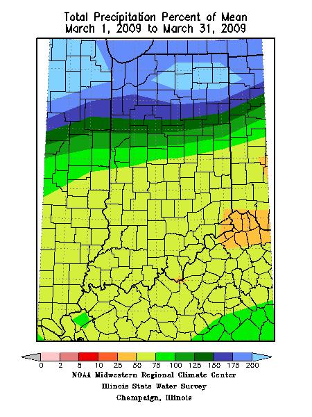
1 Joseph Mays (765) Apr 1, Summary March 2009 Climate Summary March is in the books and it continued the trend of extreme weather we have experienced during the first quarter of Major temperature swings were prevalent and widespread however the month s precipitation was not. There is a huge discrepancy in precipitation intensity from the north to the south. Weather patterns brought rain more often to the south however the states strongest storms were felt in the north. A typical transition month where you experience everything nature has to offer, March had its ups and downs as expected. In less than a week temperatures climbed or fell more than 40F. There were multiple occurrences of prolonged warmth (5 th through 10 th, 15 th through 18 th ) as well as periods abnormally cool (1 st through 3 rd, 11 th through 13 th ). When all was said and done, however, the high highs outweighed the low lows. March 2009 ranks as the 22 nd warmest March in the last 115 years. The statewide average temperature was 43.8F, 3.1F above normal. While the month saw unseasonable warmth, the precipitation patterns were awkward. More storm systems passed over the Kentucky-Indiana border than over Lake Michigan. What are we left with? The north receiving almost twice as much precipitation than the south. Why? Intensity. The storms that passed over the northern counties packed quite a punch, especially during the 7 th through 9 th when some counties received over 2.5 inches of rain. Of course there s always the lake to blame as well. March 2009 is the 57 th wettest March since It s also the 59 th driest, meaning the month is rather typical and unspectacular. Of all 115 March s on record, 2009 was about normal. That is reflected in the statewide summary where Indiana received 97% of the normal precipitation of 3.40 inches. March 1 st 10 th The end of February cold spell trickled into the first few days of March. The abnormally cold air kept high temperatures 14F or more below normal on the 1 st, 2 nd, and 3 rd. The chill was the result of high pressure centered over Minnesota and then the Great Lakes, rushing cold Canadian air into the Mid-West. When the high pressure region moved to farther to the east, warm air began to fill in behind it leaving the next few days quite warm. Temperature transitioned on the 4 th, with temperatures right around normal. Then on the 5 th and 6 th Indiana was passed over by a warm front associated with a synoptic system. The system raised high temperatures to more than 16F above normal on the 5 th, 6 th, and 7 th. Highs in the low- to mid-60s were widespread. System evolution and breakdown brought about another warm front on the 8 th, keeping temperatures
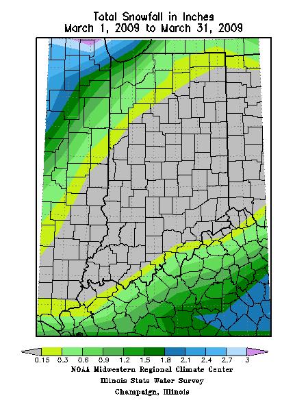
2 well above normal. Many counties across the state remained more than 18F above normal. As the cold front portion of the system passed on the 9 th, temperatures dropped off a bit but remained above normal. Another synoptic system entered on the 10 th. Once again a warm front passed raising temperatures to 70F for almost the entire state. The average high temperature for the first 10 days of March 2009 was about 55F, more than 6F above normal. The cold snap had little moisture associated with it and almost the entire state remained precipitation free until the 7 th. There was some light lake effect snow on the 2 nd. Lake, Porter, La Porte, St. Joseph, Newton, and Jasper counties all received about 0.5 inches of snow from the lake moisture. Precipitation-free days lasted until the afternoon of the 7 th, when a cold front passed. Northern and central counties experienced some rain, with accumulations of 0.3 inches. The moisture pushed further south on the 8 th and rain became heavier and more widespread. The heaviest storms raged across northern Indiana where daily precipitation totals reached more than 1.5 inches. Short-lived but severe storms passed multiple times in central and southern counties, which contained strong streamline winds and spawned multiple tornadoes. Two-day rainfall totals for the 7 th and 8 th were 2.52 inches in South Bend, 2.17 inches in Goshen, 2.21 inches in Benton Harbor, and 2.65 inches in North Webster. If the same system had passed when temperatures were cooler, the 2+ inches of rain may have been 20 inches of snow. The heavy rain passed through the north overnight, resulting in almost another inch of rain through the early morning hours on the 9 th in Lagrange, Steuben, Noble, and De Kalb counties. Another 0.25 inches feel across much of Indiana early on the 9 th before a slight reprieve. The dry conditions during the late morning, afternoon, and evening ended late that night as another system passed through the state. Heavy rain once again fell in northern Indiana, dropping another inch near the lake. A vast majority of the state saw limited precipitation, with totals of less than 0.2 inches. The consecutive systems dropped an abnormal amount of rain in a small timeframe, resulting in flooding problems. During the first 10 days of March, more than 3.5 inches of precipitation fell around the lake and more than 1.5 inches was received in the rest of the northern and central Indiana counties. The south wasn t completely spared but did receive a small amount compared with northern counties. The successive systems that crossed the state on the 7 th and then on the 10 th packed quite a punch. After no weather-related events for most of the first week, the next four days were filled with impacts associated with heavy rain and strong winds. During the late afternoon and early evening on hours on March 8 th, tornadoes were reported in or near Milan, Odon, Fayetteville, Oaktown, and Columbia City. In Milan, at least one roof was ripped off a house and there was extensive damage done to power lines along the tornado s path. In Odon, a family was lucky to survive after their mobile home was severely damaged by the tornado. A local church also suffered minor damage. At least three families ended up in the hospital after a tornado destroyed their homes in Fayetteville. One of the houses was wrecked when a school bus was picked up and tossed into it by the strong winds. In addition to the three destroyed houses, at least 19 more were damaged. Debris from the Fayetteville tornado was found in Columbus, two counties and more than 45 miles away. The Columbia City tornado touched down in a mobile home park, destroying three homes and damaging at least 20 others. The National Weather Service determined the tornado reached the intensity of an EF1, with winds up to 105 mph. It lasted for over 1.5 miles and was approximately 100 yards wide. Thankfully there were no deaths or serious injuries. Even if a tornado didn t touch down, strong winds were a problem. Streamline
3 winds were responsible for destroying silos and tearing the roof off a barn in Freelandville. The same thing happened in Flora, where a church roof was removed by strong winds. In addition to the tornadoes and streamline winds, heavy rain produced flash flooding which trapped people attempting to drive through high water in Nappanee. State police were able to rescue the trapped individuals. Minor flooding closed some roads across northern Indiana on the evening of March 8 th, including streets in South Bend, Elkhart, and Anderson. Heavy rain on the 7 th and 8 th combined with the additional rain on the 9 th and 10 th to create some severe flooding possibilities along the Wabash and Tippecanoe rivers. In White County, Diamond Point and Bluewater developments, along with the Lake Arthur Mobile Home Park, were evacuated because of the threat for major flooding. Residents of more than 55 homes were being put in a shelter at the First Christian Church in Remington. In Fort Wayne, citizens were out in full force to help local officials create sandbag and clay walls plus install pumps on the evening of March 10 th to prevent flooding in neighborhoods near the river. March 11 th 17 th When the second of successive cold fronts finally passed late on the 10 th, the state was dropped into conditions it hadn t known for more than a week: cold. Temperatures shifted more than 30F about the normal between the 10 th and 11 th. Highs reached the upper 60s on the 10 th but were now in the low 30s. Even cooler air rushed in behind the system after it vacated the Mid-West, dropping temperatures further. Highs struggled to breach 30F on the 12 th. As the cool air mass progressed to the northeast temperatures warmed and things were finally normal by the 14 th. Until, of course, we began to experience the other end of the spectrum. The jet stream pattern allowed warm Gulf air to infiltrate much of the central U.S., raising temperatures about 6-8F per day. Highs on the 15 th were in the low 50 s for most of the state. By the 17 th they approached and even pushed past 70F, more than 20F warmer than normal. Fort Wayne tied the daily high temperature record of 71F for March 17 th, also recorded on that day in The average statewide temperature for March 11 th through 17 th for Indiana is approximately 50F, about 2F above normal. Rain, and lots of it, fell for three consecutive days, from March 9 th through 11 th for most of central and northern Indiana. The heaviest fell on the evening of the 9 th and through the 10 th but residual moisture remained through the 11 th. Counties across Indiana recorded another 0.3 inches of rain on the 11 th. However the northeast was drenched. Lagrange, Steuben, Noble, De Kalb, Whitley, and Allen counties all received more than 1.5 inches of rain, and some cities in central and southern De Kalb reported close to 2 inches for the 11 th. The rain ceased on the 12 th, but with a drop in temperature combined with moisture from the lake some northwestern counties received a dusting of snow. Some light snow even fell in extreme southern parts of counties bordering Kentucky on the 13 th. A system passing to the south of Indiana skimmed a few counties dropping a light dusting of snow. As temperatures warmed on the 14 th and 15 th, the system skimming to the south brought rain to the counties bordering Kentucky. No precipitation was reported on the 16 th and 17 th, which were two fabulous days if you like warm and sunny weather. It was a quite pleasant day weather-wise for St. Patrick s Day The statewide precipitation total was, on average, about 0.8 inches. However, north central and northern counties received more than 1.5 inches this week with even higher local totals.
4 The massive amount of rain received in some counties such as Carroll, White, Jasper, and Tippecanoe from the 9 th through the 11 th caused flooding. The Tippecanoe and Wabash rivers rose to dangerous levels and did not peak in some areas until the 14 th or 15 th. About 200 homes near the Oakdale Dam were affected by flooding, though many of the homes had already been evacuated. Flow through dams along the river rose to levels rivaling those in February 2008, though not nearly as high as in January The Lake Arther Mobile Home Park in Jasper County was also evacuated due to the rising water. St. Joseph, Fulton, Plymouth, Elkhart, Whitley, and Pulaski counties issued some evacuations, too. Not only were home endangered but roads were a problem as well. High water sat across many roads in the affected counties for a day or two. No major accidents were reported but traffic was worse than usual across northern counties due to road closures and reduced lanes. Some affected cities, such as Fort Wayne, brought in additional pumps from out of state to pump sewers and roads. In Porter County, yet another region hit with flooding, a delivery woman tried to forge a flooded street and needed to be rescue by boat on a county road affected by flooding of the Kankakee River. March 18 th 24 th The abnormally warm weather that began on the 15 th continued through the 18 th. Highs across Indiana remained in the mid to upper 60 s, more than 15F above normal. Conditions reverted back to what is expected this time of year on the 19 th as the trailing cold front of a synoptic system in Canada cross the Mid-West. This normal pattern lasted a mere two days thanks to the passing of an area of high pressure which thrust warm gulf air back into the region. Temperatures again jumped into the lower 60 s on the 22 nd and 23 rd and continued to rise on the 24 th as a new system approached. The average temperature for the 18 th through 24 th of March 2009 was approximately 61F, slightly more than 9F above normal. Moisture entered central and southern counties in conjunction with the cold front late on the 18 th. Most of the rain fell during the morning and early afternoon on the 19 th. The heaviest rains were concentrated in the south central region consisting of Lawrence, Jackson, Washington, and Orange counties. There rainfall totals reach slightly more than 0.5 inches. This storm system was quite uneventful and rather weak. Save for a few passing clouds, the state received endless sunshine from the 20 th through much of the day on the 23 rd. Conditions became quite windy during the day on the 24 th thanks to an approaching synoptic system. Clouds increased and some light rain fell across western and southern counties that night. Once again the system lacked punch and weak rains produced under 0.2 inches of rain for the day. This week was mostly dry, with the northwest seeing little, if any, precipitation. The largest storm totals were received below Indianapolis, in the south central region. Still, weekly precipitation totals there were less than 0.6 inches. This drier period will make up for the wet period that occurred earlier this month. This seven day period in mid-march was quiet and safe, at least in Indiana. There were no major weather-related events or impacts of note between the 18 th and 24 th.
5 March 25 th 31 st Temperatures began to fall on the 25 th thanks to the approach and passing of a cold front throughout the day. Highs fell from the upper 60s on the 24 th to the upper 50s on the 25 th, still more than 5F above normal. A second cold front passed on the 27 th reducing highs to the low 50s, right at the normal. They d hover in this vicinity on the 28 th before rapidly falling off on the 29 th as cold arctic air rushed in behind the system. High temperatures fell into the mid 30s. A warm front passed on the 30 th allowing highs to climb back to normal to end the third month of the year. The average daily high temperature for the final week of March was 55F, about 2F above normal. Precipitation the entered the state late on the 24 th strengthened during the morning and early afternoon of the 25 th. The state was drenched with many counties reporting close to 0.5 inches of rain. The system moved slowly and dropped more rain sporadically on the southeastern counties on the 26 th and 27 th. The tail end of the second cold front contributed to the prolonged moist period and dumped more rain across Indiana on the 28 th. The storms that passed were short lived and daily rain totals barely breached 0.1 inches. As cold air filled in behind the front northwestern counties were treated with some snow and sleet on the morning and afternoon on the 29 th. Counties around the lake received over an inch; elsewhere the snow melted once it hit the ground. The southern region received some more intermittent rain resulting in another 0.5 inch in some cities. The moisture lingered into the early morning hours on the 30 th. A final system passed through western Indiana late on the 31 st, producing light showers and thunderstorms along the Illinois border. Most areas in the state received over 1.1 inches of precipitation over the final seven days of March. Southwestern counties Posey and Vanderburgh received the most, topping 2 inches. Though it was an active week for the weather, impacts were kept to a minimum. The combination of snow, sleet, and rain on the evening of the 28 th through the afternoon on the 29 th created slick roadways and more flooding concerns in northwest Indiana, around Lake Michigan. No significant accidents or injuries were reported however. March Summary Temperature Region Temperature Normal Deviation Northwest North Central Northeast West Central Central East Central Southwest South Central Southeast State
6 Precipitation Region Precipitation Normal Deviation Percent of Normal Northwest North Central Northeast West Central Central East Central Southwest South Central Southeast State Spring-to-Date (same as March) Temperature Region Temperature Normal Deviation Northwest North Central Northeast West Central Central East Central Southwest South Central Southeast State Precipitation Region Precipitation Normal Deviation Percent of Normal Northwest North Central Northeast West Central Central East Central Southwest South Central Southeast State
7 Annual-to-Date Temperature Region Temperature Normal Deviation Northwest North Central Northeast West Central Central East Central Southwest South Central Southeast State Precipitation Region Precipitation Normal Deviation Percent of Normal Northwest North Central Northeast West Central Central East Central Southwest South Central Southeast State
8
9
10
11

12 Drought Summary from the U.S. Drought Monitor Below is a drought summary for the state of Indiana from the U.S. drought monitor. Areas in white are not experiencing any drought. Yellow areas are abnormally dry, but not entirely considered a drought. Drought begins when the moisture levels become more severe, with beige, orange, red, and brown indicating increasing levels of drought (moderate, severe, extreme, and exceptional, respectively). The table below indicates how much of the state is not under drought conditions, and also how much of the state is under drought conditions from its respective column upwards. For example, March 3 rd has 100% of Indiana under no drought, and 0.00% of Indiana under at least D0 through D4 drought status. This is followed by 0.00% as D1 through D4 status. To obtain the amount that is D0 status, simply subtract the D1-D4 column from the D0- D4 column, thus giving you the percentage of area with abnormally dry conditions. Please note, however, that these areas are not exact, and much of this drought map has been created from reports throughout the state and estimation, so use this information as a general view rather than for specifics.
13 March 3 rd Drought Summary
14 March 10 th Drought Summary
15 March 17 th Drought Summary
16 March 24 th Drought Summary
January 2008 Climate Summary
 Joseph Mays (765) 494-6574 Feb 5, 2008 http://www.iclimate.org Summary January 2008 Climate Summary January was a mix bag of conditions, with an oscillatory pattern developing. We experienced phases of
August 2006 Summary. August 1-5
 Ashley Brooks (765) 494-6574 Sep 8, 2006 http://www.iclimate.org August 1-5 August 2006 Summary The heat wave that started during the end of July continued into the beginning parts of August with temperatures
July 2007 Climate Summary
 Dan Bowman (765) 494-6574 Sep 3, 2007 http://www.iclimate.org Summary July 2007 Climate Summary The month of July ended as a very unusual month. Many events occurred during the month of July that is not
September 2005 Climate Summary
 Ashley Brooks (765) 494-6574 Oct 5, 2005 http://iclimate.org September 2005 Climate Summary September 1-7 A cold front came through on the 1 st of the month, however little moisture was associated with
January 2006 Climate Summary
 Ashley Brooks (765) 494-6574 Feb 9, 2006 http://www.iclimate.org January 1-3 January 2006 Climate Summary Unseasonably warm conditions welcomed in the New Year with highs in the 40s across the northern
May 2005 Climate Summary
 Ashley Brooks (765) 494-6574 Jun 7, 2005 http://iclimate.org May 2005 Climate Summary May 1-5 Early May was characterized by an upper-level trough that was in place over Indiana that brought in very cool
October 2011 Climate Summary
 Ken Scheeringa and Kayla Hudson Nov 4, 2011 http://www.iclimate.org October 2011 Climate Summary Month Summary October weather evolved as a two part story. Weather conditions the first half of the month
2011 Year in Review TORNADOES
 2011 Year in Review The year 2011 had weather events that will be remembered for a long time. Two significant tornado outbreaks in April, widespread damage and power outages from Hurricane Irene in August
The Pennsylvania Observer
 The Pennsylvania Observer April 2, 2009 March 2009 Pennsylvania Weather Recap Prepared by Curt Harpster For the month of March the saying, In like a lion and out like a lamb really fit the pattern quite
Flood warnings were issued for the Maumee, St. Marys, Blanchard, St. Joseph (Ohio), Tippecanoe, Tiffin, Eel and Wabash Rivers on the 30 th and 31 st.
, Tippecanoe, Tiffin, Eel and Wabash Rivers on the 30 th and 31 st.") NWS FORM E-5 U.S. DEPARTMENT OF COMMERCE HSA OFFICE: NOAA, NATIONAL WEATHER SERVICE MONTHLY REPORT OF RIVER AND FLOOD CONDITIONS DATE: TO: North Webster, IN REPORT FOR (MONTH &YEAR): January 2002 February
NWS FORM E-5 U.S. DEPARTMENT OF COMMERCE HSA OFFICE: NOAA, NATIONAL WEATHER SERVICE MONTHLY REPORT OF RIVER AND FLOOD CONDITIONS DATE: TO: North Webster, IN REPORT FOR (MONTH &YEAR): January 2002 February
Champaign-Urbana 1998 Annual Weather Summary
 Champaign-Urbana 1998 Annual Weather Summary ILLINOIS STATE WATER SURVEY Audrey Bryan, Weather Observer 2204 Griffith Dr. Champaign, IL 61820 wxobsrvr@sparc.sws.uiuc.edu The development of the El Nìno
The hydrologic service area (HSA) for this office covers Central Kentucky and South Central Indiana.
 for this office covers Central Kentucky and South Central Indiana.") MONTH YEAR January 2011 February 15, 2011 X An X inside this box indicates that no flooding occurred within this hydrologic service area. January 2011 was drier than normal in all locations in the area.
MONTH YEAR January 2011 February 15, 2011 X An X inside this box indicates that no flooding occurred within this hydrologic service area. January 2011 was drier than normal in all locations in the area.
The hydrologic service area (HSA) for this office covers Central Kentucky and South Central Indiana.
 for this office covers Central Kentucky and South Central Indiana.") January 2012 February 13, 2012 An X inside this box indicates that no flooding occurred within this hydrologic service area. January 2012 continued the string of wet months this winter. Rainfall was generally
January 2012 February 13, 2012 An X inside this box indicates that no flooding occurred within this hydrologic service area. January 2012 continued the string of wet months this winter. Rainfall was generally
MONTHLY REPORT OF RIVER AND FLOOD CONDITIONS
 NWS FORM E-5 U.S. DEPARTMENT OF COMMERCE HSA OFFICE: NOAA, NATIONAL WEATHER SERVICE NWS Northern Indiana (IWX) REPORT FOR (MONTH&YEAR): January 2005 MONTHLY REPORT OF RIVER AND FLOOD CONDITIONS DATE: February
December 2011 Climate Summary
 Ken Scheeringa and Kayla Hudson Jan 17, 2012 (765) 494-8105 http://www.iclimate.org December 2011 Climate Summary Month Summary What a difference a year makes! A year ago the misery of a harsh, cold, and
NWS FORM E-5 U.S. DEPARTMENT OF COMMERCE HSA OFFICE:
 NWS FORM E-5 U.S. DEPARTMENT OF COMMERCE HSA OFFICE: NOAA, NATIONAL WEATHER SERVICE MONTHLY REPORT OF RIVER AND FLOOD CONDITIONS DATE: TO: North Webster, IN REPORT FOR (MONTH &YEAR): July 1998 August 5,
March 2014 Climate Summary
 Ken Scheeringa And Matt Price Apr 8, 2014 (765) 494-8105 http://www.iclimate.org March 2014 Climate Summary Month Summary Winter had officially ended by the calendar but snow and cold persisted in Indiana
Above normal temperatures and precipitation continue across the HSA
 NWS Form E-5 (PRES. BY NWS Instruction 10-924) MONTHLY REPORT OF HYDROLOGIC CONDITIONS HYDROLOGIC SERVICE AREA (HSA) MONTH YEAR TO: Hydrologic Information Center, W/OS31 NOAA s National Weather Service
NATIONAL WEATHER SERVICE
 NWS Form E-5 (PRES. BY NWS Instruction 10-924) MONTHLY REPORT OF HYDROLOGIC CONDITIONS HYDROLOGIC SERVICE AREA (HSA) NORTHERN INDIANA (IWX) MONTH YEAR TO: Hydrologic Information Center, W/OS31 NOAA s National
August 2017 Climate Summary
 Ken Scheeringa And Andy Eggert Sep 7, 2017 (765) 494-8105 http://www.iclimate.org August 2017 Climate Summary Month Summary The coolest August in 13 years featured long cool and warm spells, below normal
2018 Year in Review for Central and Southeast Illinois By: Chris Geelhart, Meteorologist National Weather Service, Lincoln IL
 By: Chris Geelhart, Meteorologist National Weather Service, Lincoln IL While 2018 featured some significant out-of-season weather, including below zero temperatures in April and 90-degree highs in early
X An X inside this box indicates that no flooding occurred within this Hydrologic Service Area.
 NWS FORM E-5 U.S. DEPARTMENT OF COMMERCE HSA OFFICE: NOAA, NATIONAL WEATHER SERVICE MONTHLY REPORT OF RIVER AND FLOOD CONDITIONS DATE: TO: North Webster, IN REPORT FOR (MONTH &YEAR): January, 2003 February
NATIONAL WEATHER SERVICE
 NWS Form E-5 (PRES. BY NWS Instruction 10-924) MONTHLY REPORT OF HYDROLOGIC CONDITIONS HYDROLOGIC SERVICE AREA (HSA) MONTH YEAR TO: Hydrologic Information Center, W/OS31 NOAA s National Weather Service
NWS FORM E-5 U.S. DEPARTMENT OF COMMERCE HSA OFFICE:
 NWS FORM E-5 U.S. DEPARTMENT OF COMMERCE HSA OFFICE: NOAA, NATIONAL WEATHER SERVICE MONTHLY REPORT OF RIVER AND FLOOD CONDITIONS DATE: TO: North Webster, IN REPORT FOR (MONTH &YEAR): January 2001 February
November 2012 Climate Summary
 Ken Scheeringa and Kayla Hudson Dec 6, 2012 (765) 494-8105 http://www.iclimate.org November 2012 Climate Summary Month Summary November was one of those rare weather months in Indiana when not much happened:
August 2013 Climate Summary
 Ken Scheeringa and Matt Price Sep 6, 2013 (765) 494-8105 http://www.iclimate.org August 2013 Climate Summary Month Summary August weather began cool and wet but became progressively warmer and drier through
SIGNIFICANT EVENTS Severe Storms November 1994 January 1996 August 1998 and May 2000 March 2002 May 2002 Champaign County
 SIGNIFICANT EVENTS Severe Storms November 1994 On Nov. 1, 1994, high winds gusted over 60 mph at times across the northwest third of Ohio. The highest measured wind gust was 63 mph at Columbus Grove (Putnam).
NWS FORM E-5 U.S. DEPARTMENT OF COMMERCE I HYDRO SERVICE AREA NOAA, NATIONAL WEATHER SERVICE I Indianapolis, IN MONTHLY REPORT
 NWS FORM E-5 U.S. DEPARTMENT OF COMMERCE I HYDRO SERVICE AREA NOAA, NATIONAL WEATHER SERVICE I Indianapolis, IN. 1-------------------- MONTHLY REPORT OF RIVER AND FLOOD CONDITIONSI REPORT FOR I November
The Pennsylvania Observer
 The Pennsylvania Observer August 3, 2015 July 2015 - Pennsylvania Weather Recap By: Arthur Person Although this seventh month of 2015 was fairly normal across Pennsylvania as a whole, the details reveal
June 2010 Climate Summary
 Ken Scheeringa (765) 494-8105 Jul 6, 2010 http://www.iclimate.org June 2010 Climate Summary Summary Summer like heat and humidity arrived in Indiana on May 22 nd and dominated our weather scene nearly
INDIANAPOLIS, INDIANA
 The NWS FORM E-5 U.S. DEPARTMENT OF COMMERCE HYDROLOGIC SERVICE AREA: NATIONAL OCEANIC AND ATMOSPHERIC ADMINISTRATION NATIONAL WEATHER SERVICE INDIANAPOLIS, INDIANA REPORT FOR: MONTHLY REPORT OF RIVER
November 2014 Climate Summary
 Ken Scheeringa And Matt Price Dec 10, 2014 (765) 494-8105 http://www.iclimate.org November 2014 Climate Summary Month Summary Unseasonable cold headlined the Indiana and national news in November. The
but 2012 was dry Most farmers pulled in a crop
 After a winter that wasn t, conditions late in the year pointed to a return to normal snow and cold conditions Most farmers pulled in a crop but 2012 was dry b y M i k e Wr o b l e w s k i, w e a t h e
Monthly Long Range Weather Commentary Issued: July 18, 2014 Steven A. Root, CCM, President/CEO
 Monthly Long Range Weather Commentary Issued: July 18, 2014 Steven A. Root, CCM, President/CEO sroot@weatherbank.com JUNE 2014 REVIEW Climate Highlights The Month in Review The average temperature for
January 2013 Climate Summary
 Ken Scheeringa and Kayla Hudson Feb 7, 2013 (765) 494-8105 http://www.iclimate.org January 2013 Climate Summary Month Summary Winter or spring? January featured several dramatic swings in temperature and
Champaign-Urbana 2001 Annual Weather Summary
 Champaign-Urbana 2001 Annual Weather Summary ILLINOIS STATE WATER SURVEY 2204 Griffith Dr. Champaign, IL 61820 wxobsrvr@sws.uiuc.edu Maria Peters, Weather Observer January: After a cold and snowy December,
January 2012 Climate Summary
 Ken Scheeringa and Kayla Hudson Feb 6, 2012 (765) 494-8105 http://www.iclimate.org January 2012 Climate Summary Month Summary Where is winter? This question found its way into many conversations throughout
2012 Growing Season Weather Summary for North Dakota. Adnan Akyüz and Barbara A. Mullins Department of Soil Science October 30, 2012
 2012 Growing Season Weather Summary for North Dakota Adnan Akyüz and Barbara A. Mullins Department of Soil Science October 30, 2012 Introduction The 2012 growing season (the period from April through September)
Monthly Long Range Weather Commentary Issued: APRIL 18, 2017 Steven A. Root, CCM, Chief Analytics Officer, Sr. VP,
 Monthly Long Range Weather Commentary Issued: APRIL 18, 2017 Steven A. Root, CCM, Chief Analytics Officer, Sr. VP, sroot@weatherbank.com MARCH 2017 Climate Highlights The Month in Review The average contiguous
New Hampshire State Climate Office Dr. Mary D. Stampone, State Climatologist
 New Hampshire State Climate Office Dr. Mary D. Stampone, State Climatologist University of New Hampshire c/o Department of Geography 73 Main Street Durham, NH 03824 Phone: 603-862-3136 Fax: 603-862-4362
September 2011 Climate Summary
 Ken Scheeringa and Kayla Hudson Oct 5, 2011 (765) 494-8105 http://www.iclimate.org September 2011 Climate Summary Month Summary The final blast of summer heat arrived at the start of September. It lasted
May 2016 Volume 23 Number 5
 The Weather Wire May 2016 Volume 23 Number 5 Contents: Winter Summary Current Colorado and West-wide Snow Pack Drought Monitor April Summary/Statistics May Preview Snowfall Totals Winter Summary The Front
The Pennsylvania Observer
 The Pennsylvania Observer September 3, 2008 Summer 2008 Weather Summary Written by: Brian Thompson The opening days of June started dry, but a warm front brought a widespread rain a couple of days into
NATIONAL WEATHER SERVICE
 NWS Form E-5 (PRES. BY NWS Instruction 10-924) MONTHLY REPORT OF HYDROLOGIC CONDITIONS HYDROLOGIC SERVICE AREA (HSA) MONTH YEAR TO: Hydrologic Information Center, W/OS31 NOAA s National Weather Service
NATIONAL WEATHER SERVICE
 January 2016 February 9, 2016 This was a dry month across the HSA despite one large and several smaller snowfalls. Most locations ended up 1-2 inches below normal for the month. The driest locations at
Monthly Long Range Weather Commentary Issued: May 15, 2014 Steven A. Root, CCM, President/CEO
 Monthly Long Range Weather Commentary Issued: May 15, 2014 Steven A. Root, CCM, President/CEO sroot@weatherbank.com APRIL 2014 REVIEW Climate Highlights The Month in Review The average temperature for
HAZARD DESCRIPTION... 1 LOCATION... 1 EXTENT... 1 HISTORICAL OCCURRENCES...
 WINTER STORM HAZARD DESCRIPTION... 1 LOCATION... 1 EXTENT... 1 HISTORICAL OCCURRENCES... 3 SIGNIFICANT PAST EVENTS... 4 PROBABILITY OF FUTURE EVENTS... 5 VULNERABILITY AND IMPACT... 5 Hazard Description
The Pennsylvania Observer
 The Pennsylvania Observer October 1, 2015 September 2015 - Pennsylvania Weather Recap By: Quinn Lease The month of September will be remembered for its above normal temperatures and dry conditions that
The Pennsylvania Observer
 The Pennsylvania Observer May 31, 2012 May 2012 - Pennsylvania Weather Recap By: Paul Knight The majority of the fifth month had temperatures averaging well above seasonal levels with two distinct hot
January 2017 Climate Summary
 Ken Scheeringa And Andy Eggert Feb 8, 2017 (765) 494-8105 http://www.iclimate.org January 2017 Climate Summary Month Summary The warmest January in 11 years was nearly 4 F warmer than December 2016. An
Monthly Long Range Weather Commentary Issued: February 15, 2015 Steven A. Root, CCM, President/CEO
 Monthly Long Range Weather Commentary Issued: February 15, 2015 Steven A. Root, CCM, President/CEO sroot@weatherbank.com JANUARY 2015 Climate Highlights The Month in Review During January, the average
KANSAS CLIMATE SUMMARY February 2015
 KANSAS CLIMATE SUMMARY February 2015 Extended Cold Despite some record warm readings at a few locations, February was characterized by colder than normal conditions. This was particularly true during the
Storm and Storm Systems Related Vocabulary and Definitions. Magnitudes are measured differently for different hazard types:
 Storm and Storm Systems Related Vocabulary and Definitions Magnitude: this is an indication of the scale of an event, often synonymous with intensity or size. In natural systems, magnitude is also related
NWS FORM E-5 U.S. DEPARTMENT OF COMMERCE HSA OFFICE: NOAA, NATIONAL WEATHER SERVICE North Webster, IN
 NWS FORM E-5 U.S. DEPARTMENT OF COMMERCE HSA OFFICE: NOAA, NATIONAL WEATHER SERVICE North Webster, IN REPORT FOR (MONTH &YEAR): January 1999 MONTHLY REPORT OF RIVER AND FLOOD CONDITIONS DATE: February
NIDIS Weekly Climate, Water and Drought Assessment Summary. Upper Colorado River Basin July 31, 2012
 NIDIS Weekly Climate, Water and Drought Assessment Summary Upper Colorado River Basin July 31, 2012 Fig. 1: July month-to-date precipitation in inches. Fig. 2: SNOTEL WYTD precipitation percentiles (50%
Impacts of the April 2013 Mean trough over central North America
 Impacts of the April 2013 Mean trough over central North America By Richard H. Grumm National Weather Service State College, PA Abstract: The mean 500 hpa flow over North America featured a trough over
KANSAS CLIMATE SUMMARY January 2018
 KANSAS CLIMATE SUMMARY January 2018 Some welcome moisture After an extended period with little to no moisture, parts of Kansas recorded some significant precipitation. At Tribune, a small snow event on
The Weather Wire. Contents: Summer 2018 Outlook. Summer 2018 Outlook Drought Monitor May Summary/Statistics June Preview Rainfall Totals
 The Weather Wire June 2018 Volume 25 Number 6 Contents: Summer 2018 Outlook Drought Monitor May Summary/Statistics June Preview Rainfall Totals Summer 2018 Outlook June 1 st marked the first day of meteorological
W I N T E R STORM HAZARD DESCRIPTION
 W I N T E R STORM HAZARD DESCRIPTION... 1 LOCATION... 2 EXTENT... 2 HISTORICAL OCCURRENCES... 4 SIGNIFICANT PAST EVENTS... 4 PROBABILITY OF FUTURE EVENTS... 5 VULNERABILITY AND IMPACT... 5 HAZARD DESCRIPTION
National Wildland Significant Fire Potential Outlook
 National Wildland Significant Fire Potential Outlook National Interagency Fire Center Predictive Services Issued: September, 2007 Wildland Fire Outlook September through December 2007 Significant fire
Fronts. Direction of Front
 Fronts Direction of Front Direction of Front Warm Front A cold air mass meets and displaces a warm air mass. Because the moving cold air is more dense, it moves under the less-dense warm air, pushing it
SEPTEMBER 2013 REVIEW
 Monthly Long Range Weather Commentary Issued: October 21, 2013 Steven A. Root, CCM, President/CEO sroot@weatherbank.com SEPTEMBER 2013 REVIEW Climate Highlights The Month in Review The average temperature
July 2010 Climate Summary
 Ken Scheeringa (765) 494-8105 Aug 4, 2010 http://www.iclimate.org July 2010 Climate Summary Summary The warm summer of 2010 continues. Daily state average temperatures were above normal on all but seven
Champaign-Urbana 1999 Annual Weather Summary
 Champaign-Urbana 1999 Annual Weather Summary ILLINOIS STATE WATER SURVEY 2204 Griffith Dr. Champaign, IL 61820 wxobsrvr@sws.uiuc.edu Maria Peters, Weather Observer A major snowstorm kicked off the new
MIAMI-SOUTH FLORIDA National Weather Service Forecast Office
 MIAMI-SOUTH FLORIDA National Weather Service Forecast Office http://www.weather.gov/miami June 2015 South Florida Weather Summary Dry East, Wet West...Drought Remains SE Florida July 3, 2015: Depending
The weather in Iceland 2012
 The Icelandic Meteorological Office Climate summary 2012 published 9.1.2013 The weather in Iceland 2012 Climate summary Sunset in Reykjavík 24th April 2012 at 21:42. View towards west from the balcony
How strong does wind have to be to topple a garbage can?
 How strong does wind have to be to topple a garbage can? Imagine winds powerful enough to pick up a truck and toss it the length of a football field. Winds of this extreme sometimes happen in a tornado.
2011 National Seasonal Assessment Workshop for the Eastern, Southern, & Southwest Geographic Areas
 2011 National Seasonal Assessment Workshop for the Eastern, Southern, & Southwest Geographic Areas On January 11-13, 2011, wildland fire, weather, and climate met virtually for the ninth annual National
June 2011 Climate Summary
 Ken Scheeringa (765) 494-8105 Jul 8, 2011 http://www.iclimate.org June 2011 Climate Summary Month Summary The abundance of extreme weather this year extended yet another month into June. This month has
Arizona Climate Summary May 2012
 Arizona Climate Summary May 2012 Summary of conditions for April 2012 April 2012 Temperature and Precipitation Summary April 1 st 16 th : Although April began with another low pressure system sweeping
April 2013 Climate Summary
 Ken Scheeringa and Kayla Hudson May 6, 2013 (765) 494-8105 http://www.iclimate.org April 2013 Climate Summary Month Summary Temperatures bounced high and low this month, keeping Hoosiers guessing which
May 2015 Climate Summary
 Ken Scheeringa And Mary Rose Mangan Jun 8, 2015 (765) 494-8105 http://www.iclimate.org May 2015 Climate Summary Month Summary May was a very warm month. Rainfall averaged near normal but was distributed
Weather and Climate Summary and Forecast August 2018 Report
 Weather and Climate Summary and Forecast August 2018 Report Gregory V. Jones Linfield College August 5, 2018 Summary: July 2018 will likely go down as one of the top five warmest July s on record for many
NIDIS Drought and Water Assessment
 NIDIS Drought and Water Assessment PRECIPITATION The images above use daily precipitation statistics from NWS COOP, CoCoRaHS, and CoAgMet stations. From top to bottom, and left to right: most recent 7-days
November 2010 Climate Summary
 Ken Scheeringa (765) 494-8105 Dec 6, 2010 http://www.iclimate.org November 2010 Climate Summary Summary A four month drought in Indiana is collapsing as significant rain fell the final week of November.
PRECIPITATION. Last Week Precipitation:
 2/24/2015 NIDIS Drought and Water Assessment PRECIPITATION The images above use daily precipitation statistics from NWS COOP, CoCoRaHS, and CoAgMet stations. From top to bottom, and left to right: most
The Pennsylvania Observer
 The Pennsylvania Observer June 2, 2010 May 2010 Pennsylvania Weather Recap This month completed one of the warmest springs on record in Pennsylvania. With about 75% of the days averaging above normal,
July 2011 Climate Summary
 Ken Scheeringa (765) 494-8105 Aug 8, 2011 http://www.iclimate.org July 2011 Climate Summary Month Summary The upper atmospheric high pressure dome which baked the Texas area in heat and drought the past
Weather and Climate Summary and Forecast March 2019 Report
 Weather and Climate Summary and Forecast March 2019 Report Gregory V. Jones Linfield College March 2, 2019 Summary: Dramatic flip from a mild winter to a top five coldest February on record in many locations
SOUTHERN CLIMATE MONITOR
 SOUTHERN CLIMATE MONITOR MARCH 2011 VOLUME 1, ISSUE 3 IN THIS ISSUE: Page 2 to 4 Severe Thunderstorm Climatology in the SCIPP Region Page 4 Drought Update Page 5 Southern U.S. Precipitation Summary for
April 2011 Climate Summary
 Ken Scheeringa (765) 494-8105 May 9, 2011 http://www.iclimate.org April 2011 Climate Summary Summary After somewhat of a respite in March Indiana weather ramped up with a vengeance in April. Extreme weather
Minor Winter Flooding Event in northwestern Pennsylvania January 2017
 1. Overview Minor Winter Flooding Event in northwestern Pennsylvania 12-13 January 2017 By Richard H. Grumm National Weather Service State College, PA A combination of snow melt, frozen ground, and areas
WeatherManager Weekly
 Issue 288 July 14, 2016 WeatherManager Weekly Industries We Serve Agriculture Energy/Utilities Construction Transportation Retail Our Weather Protection Products Standard Temperature Products Lowest Daily
Weather: Air Patterns
 Weather: Air Patterns Weather: Air Patterns Weather results from global patterns in the atmosphere interacting with local conditions. You have probably experienced seasonal shifts, such as winter in New
March 2016 Climate Summary
 Ken Scheeringa And Andy Eggert Apr 8, 2016 (765) 494-8105 http://www.iclimate.org March 2016 Climate Summary Month Summary Count March as the 7 th month in a row that the state average temperature has
Weather and Climate Summary and Forecast October 2017 Report
 Weather and Climate Summary and Forecast October 2017 Report Gregory V. Jones Linfield College October 4, 2017 Summary: Typical variability in September temperatures with the onset of fall conditions evident
chapter one climatology
 chapter one Precipitation Observer Network June 2002 (1467 Observers) May 2003 Introduction The DNR Waters State Climatology Office exists to gather and analyze climate data for the benefit of the State
Arizona Climate Summary September 2017 Summary of conditions for August 2017
 August 2017 Temperature and Precipitation Summary Arizona Climate Summary September 2017 Summary of conditions for August 2017 August 1 st 15 th : The monsoon activity that ended July continued into the
2015: A YEAR IN REVIEW F.S. ANSLOW
 2015: A YEAR IN REVIEW F.S. ANSLOW 1 INTRODUCTION Recently, three of the major centres for global climate monitoring determined with high confidence that 2015 was the warmest year on record, globally.
Monthly Long Range Weather Commentary Issued: APRIL 1, 2015 Steven A. Root, CCM, President/CEO
 Monthly Long Range Weather Commentary Issued: APRIL 1, 2015 Steven A. Root, CCM, President/CEO sroot@weatherbank.com FEBRUARY 2015 Climate Highlights The Month in Review The February contiguous U.S. temperature
Arizona Climate Summary February 2016 Summary of conditions for January 2016
 January 2016 Temperature and Precipitation Summary Arizona Climate Summary February 2016 Summary of conditions for January 2016 January 1 st 14 th : The new year began with high pressure over the southwest
Arizona Climate Summary September 2014 Summary of conditions for August 2014
 Arizona Climate Summary September 2014 Summary of conditions for August 2014 August 2014 Temperature and Precipitation Summary August 1 st 16 th : The first 5 days of August were quite wet with high pressure
Arizona Climate Summary
 May 2015 Temperature and Precipitation Summary Arizona Climate Summary June 2015 Summary of conditions for May 2015 May 1 st 14 th : May began with high pressure in the west, and May 1 st was dry statewide,
Illinois Drought Update, December 1, 2005 DROUGHT RESPONSE TASK FORCE Illinois State Water Survey, Department of Natural Resources
 Illinois Drought Update, December 1, 2005 DROUGHT RESPONSE TASK FORCE Illinois State Water Survey, Department of Natural Resources For more drought information please go to http://www.sws.uiuc.edu/. SUMMARY.
Weather and Climate 1. Elements of the weather
 Weather and Climate 1 affect = to have an effect on, influence, change altitude = the height of a place above the sea axis = the line around which an object rotates certain = special consist of = to be
Weather and Climate Summary and Forecast January 2019 Report
 Weather and Climate Summary and Forecast January 2019 Report Gregory V. Jones Linfield College January 4, 2019 Summary: December was mild and dry over much of the west, while the east was much warmer than
Weather and Climate Summary and Forecast April 2018 Report
 Weather and Climate Summary and Forecast April 2018 Report Gregory V. Jones Linfield College April 4, 2018 Summary: A near Miracle March played out bringing cooler and wetter conditions to the majority
HURRICANES AND TORNADOES
 HURRICANES AND TORNADOES The most severe weather systems are hurricanes and tornadoes. They occur in extremely low pressure systems, or cyclones, when the air spirals rapidly into the center of a low.
TFS WEATHER BRIEF. Monday, March 25
 TFS WEATHER BRIEF Monday, March 25 Review: The leading edge of cooler and drier air was pushing through Central and East TX this morning. A few lingering thunderstorms were in progress south of I-20 in
Arizona Climate Summary February 2012
 Arizona Climate Summary February 2012 Summary of conditions for January 2012 January 2012 Temperature and Precipitation Summary January 1 st 20 th : The New Year has started on a very dry note. The La