extracted from the book ILLUSTRATING TIME S SHADOW The book ILLUSTRATING TIME S SHADOW is available using PayPal on the web site CUBIC Shadows
|
|
|
- Cecil Ward
- 5 years ago
- Views:
Transcription

1 CUBIC Shadows How to make a CUBIC sun dial for the common latitudes of the planet earth. The cube dial pictured above is latitude specific. This book shows how to use one set of dial plates for any latitude. However, using the DeltaCAD macros, latitude specific dial plates are easily built. Simon Wheaton-Smith November 2010
2 CUBIC Shadows Introduction TABLE OF CONTENTS Get Started BUILD IT FIRST AND FIGURE IT OUT NEXT Chapter 1 Chapter 2 Chapter 3 Chapter 4 Chapter 5 Chapter 6 Chapter 7 The evolution of the dial How the earth and sun do their thing Determining true north since we need the polar axis Sundial construction and key points A horizontal dial a short design course and using the Foster, Serle, or Middleton Scales Polar and Meridian dials a short design course The cubic dials Appendix NOTE: Please also check SIMPLE SHADOWS, it has some additional material that is not in the booklet. FREE Please download:- cubicshadows.xls for Excel or cubicshadows.ods for Open Office or cubicshadows.wks for MS Works or cubicshadows.bas for DeltaCAD from:- or illustrating-shadows.xls for Excel or illustrating-shadows.ods for Open Office (c) Simon Wheaton-Smith All rights reserved. However, this may be given as is for no cost beyond copying, to anyone; and selections may be copied provided credit is given to this book, author, and referenced works, and the author ed for information purposes at: illustratingshadows@yahoo.com Please check: regularly for articles, updates, templates, or spreadsheets. An all purpose spreadsheet covering many dialing functions is available there. ISBN ISBN


3 INTRODUCTION There are a number of books on sundials, some easier to find, some harder, yet they all provide a wealth of information. From a personally biased perspective, ILLUSTRATING TIME S SHADOW is by far the best!. I had grown up with a few sundials, and a lot of clocks. I collected clocks, and when I was a teenager I was given a portable sundial, and later I acquired some astrolabes. The house I was born in was Pilton Manor in Somerset, England. We had one sundial I had a picture of, but I was too small to be able to read it. Then in 1951 we moved to Hey Farm in Somerset also, an old house in much need of repair. In the east end of the lawn there was an old sundial. It was missing some pieces, yet together with its moss and the occasional present from a visiting bird, it was a feature of our life, and a center piece when we used to have tea or picnics on the lawn. Pilton's sundial I built a number of sundials, some worked better than others and I found what did and did not work. In reading the books I was somewhat frustrated by geometric Hey Farm's sundial projections that were not always clear and took a long time to comprehend, some seemed to have some non sequiturs, and the diagrams were not on the same page as the text making it harder still. Some even used different symbols than their associated descriptive text. Some books even appeared to be inconsistent. One book would be great at this feature, poor at another, thus I started to collect charts, tables, and methods. Above to the left is the author's stone sundial of his youth in the 1950s. The objective of this book is to show clearly how to make a cubic sun dial for all sorts of places. Enjoy your trip to a world of sunlight. Simon Wheaton-Smith FRI, MBCS, CITP Member of the North American Sundial Society 3

4 A QUICK HANDS ON PROJECT ~ ~ ~ LOCATION & A HORIZONTAL DIAL The next two pages offer a simple "go ahead and build it" horizontal sundial, then see what needs to be done to make it accurate. The rest of the book is the other way around, theory to understand what is going on, then build it. These two pages help you build a horizontal dial and for all readers, this is a good prelude to the rest of the book. And now, some questions 1. What is your latitude (how far north or south are you from the equator). Many maps show this, and so does a GPS. In the appendices, Table A2.5 may help as may some of the maps there. my latitude is: 2. EITHER download the spreadsheet at: then on the worksheet named "h dial with all figures", enter the latitude. OR go to tables A3.1a, A3.1b, or A3.1c in the appendices, look at the latitude at the top of the columns, then find the angles for the hours you wish marked noon morning hours noon afternoon hours 3. Mark the lines on the template "A DRAFTING SHEET FOR HORIZONTAL DIALS" from the appendices. The end result should look roughly like the fan of lines to the right. Noon is going to be on the north south line and the 6am and 6pm lines will be at 90 degrees to that, The other lines will fan out, and their angles depend on your latitude. 4. Transpose the hour lines to wood, PVC, copper, glass, concrete, or any other medium. This is called the dial plate. dial center dial plate gnomon 5. Build a shadow casting device, called a gnomon, it is a triangle whose angle from the dial plate is equal to the latitude. The angle is important, the length is not, unless you want to add other information related to the time of year, discussed in the main part of the book. 6. Affix the gnomon to the dial plate, the latitude angle end rests on top of where the hour lines converge (dial center), and it lies on the north south line, or the noon line. gnomon latitude style to the equator to the nearest pole dial center 4
5 7. Take the dial plate, it's affixed gnomon on the noon line and place it in the sun. 8. Align the noon line with north/south, and the gnomon's end placed on dial center (where it meets the hour lines), should point to the equator, south in the northern hemisphere or north in the southern hemisphere. By north, true north is meant, not the north where a compass points. To find true north, first find magnetic north by using a compass but keep away from metal. Then find your location's magnetic variation, or declination as sun dial people call it. If it is an easterly declination you must back away from north to the west. If it is a westerly declination, you must back away from north to the east. Magnetic declinations are often found on maps, and a table and a map in the appendix has declination information. my magnetic declination: E Table A2.5 and the maps in appendix 2 may W help, and many websites also, you may try: 9. With the dial plate level, the angled part of the gnomon pointing north south, the dial will now read sun-time, or local-apparent-time or LAT for short. It is still not clock accurate. There are two corrections to make. One is to correct for your distance from your time zone's reference longitude, the other is for the fact the sun is predictably slow or fast (compared to man made watches) as the year progresses, this correction is called the equation of time or EOT for short. 10. Find your longitude, it is on your GPS unit, or on a map of your area. Aviation and geological survey maps work, but road maps may not. Once you know your longitude, and your time zone, find your time zone's reference longitude. my longitude is: Table A2.5 in the appendices may help. my time zone reference is: Table A2.6 in the appendices may help. difference between the two is: times 4 is: minutes If your longitude is larger than the reference longitude, then ADD the difference times 4, this is the minutes to add to correct for your location. If your longitude is smaller than the reference longitude, then SUBTRACT the difference times 4, this is the minutes to add to correct for your location. plus [ ] or minus [ ] _ minutes to correct for location. 11. We now have a dial built for your latitude, aligned north/south, and corrected for your location's distance from the time zone's reference longitude. However it may still be off by plus or minus up to 16 minutes due to the fact the sun's orbit around the earth varies as the year progresses, and the sun similarly moves north or south of the equator. There is a table of corrections for this equation of time or EOT, table A2.1 is by the day. 12. That is it! You now have a working horizontal sun dial. To delve into it more, read on.... 5


6 USEFUL DEFINITIONS CHAPTER 1 THE EVOLUTION OF THE DIAL The EOT, or equation of time is the difference between the real apparent sun and a virtual perfectly on-time sun that matches the modern "accurate" clock Altitude how high above the horizon the sun is, measured in degrees. Azimuth ~ how far east or west of the north-south line the sun is, measured in degrees. Since the earliest days of the human race, it was important to know when to plant, when to hunt, and a calendar was needed and developed. The sun's angle in the sky compared to the horizon, is its altitude, and early Egyptians employed such dials. Early altitude dial The sun woke up and climbed, ran out of energy in mid day, and becoming tired, descended into the arms of Morpheus. The early Egyptians built a simple dial that could be turned toward the sun, and its angle at mid day cast a shadow of decreasing length as the climate became warmer. Alignment with true north or south was not needed for these altitude measuring dials, since the reference was the sun, and the horizon. For all altitude dials, north south alignment is not used but the date must be known if the one is to tell the time. As time became more important than the calendar, early Greeks, Arabs, and Romans had business to conduct. And so developed a sundial that measured the azimuth of the sun, its angle compared with true north or south. Such early dials often divided daylight into pieces, yet those pieces were not always of equal duration, sometimes they were just arbitrary divisions. Azimuth dials do not required a gnomon of a calculated height. The line of the shadow aligns with hour lines, or points to hour points. Of course time, altitude, and azimuth are all somewhat related. And a definitive study of dial history may not show such a sequenced development because different areas of the world evolved differently. As the horse and carriage produced rapid transportation, people needed common time keeping, and equal hours. So was ushered in the perfected sundial. That perfected dial used the angle the sun makes as it appears to orbit around the earth's north-south polar axis. Early azimuth dial The reader may have noticed that the sun runs slow or fast depending on the day of the year. Sun dials use the solar position as the basis for date and for time. The earth orbits the sun, however not by an exact number of days, and even those days vary in an annual cycle. So even city slicker watches are not synchronized as well as we might think. Is the synchronization with the daily rotation of the earth, the annual rotation around the sun, or with the fixed stars? 6


7 CHAPTER 2 HOW THE EARTH AND SUN DO THEIR THING The earth is a planet and from history we know it orbits the sun. Back in medieval times the sun rotated around the earth. Galileo and others nearly got burned at the stake when they said it was the other way round, however it is pretty much accepted that the earth moves around the sun, and by the way, the earth is no longer flat either, it is a sphere in space. Sun The polar axis is what the earth's surface spins around, or in essence, around which the sun apparently rotates. And we call the line running around the middle of the earth, the equator, which is perpendicular to the polar axis. Fig 2.1 Earth The blue thing we live on is planet earth, and what is more it is tilted. That is why the seasons vary, and it has a polar axis, and an equator which is at 90 degrees to that axis. The axis is what the earth's surface spins around. That axis is tiled about 23.5 and, looking at figure 2.2, when the sun is below the equator (bottom left in the figure below), the southern hemisphere enjoys summer, and when the sun above the equator (top right in the figure below), winter prevails down under, and summer returns to the northern hemisphere. The earth orbits the sun in an ellipse called the ecliptic, and that together with the earth's tilt, is why day length varies, and why the sun's hours vary somewhat, and hence why the equation of time was developed which corrects the sun for being slow or fast when compared to the watches and clocks. The ecliptic is 23.5 degrees off from the earth's equator. The pictorial below shows the earth spinning on its axis, and the sun in four different positions. equinox tropics Polar axis summer solstice in England is winter solstice in Australia. winter solstice equator in England is summer solstice note how the in Australia sun is below, on, or above the equator. Fig 2.2 equinox When the sun is directly in front, or directly behind the earth in the picture above, it is the equinox, and the days are equal to the nights in duration. By the way, every day on the equator is an equinox, their days are the same length as their nights. While the earth rotates around the sun, to a sundial it is as if the sun goes around the earth's polar axis, so sometimes we will assume it is before the days Galileo! Whatever works. It is all relative anyway. 7


8 Now let us define a few things that are needed in order to understand location on planet earth. The pole around which the earth spins is tilted by about 23.5 and perpendicular to it is the plane called the equator, see figure 2.3. polar axis By the way, if the earth looks bigger than polar the sun, axis it is because the sun looks small to us here on planet earth, and the earth looks big to us. earth Fig equator sun Referring to figure 2.4, as a convenience, the earth is sliced up into sections parallel to the equator, and those slices are measured by their angle to the 23.5 center of the earth. Those angles are called latitude and Ø is its common symbol. The latitude tells you how far north or south of the equator you are. It is measured in degrees, the equator's latitude is 0 while the north pole is 90, and one degree of latitude is about 60 nautical miles on the surface, that is how nautical miles came into being. But how do you know where you are left or right on the planet. The equator is an obvious slice for latitude references, as it is 90 to the polar axis, but there is no such obvious place for the left-right position, so England graciously agreed to defined Greenwich as the reference point. Fig 2.4 latitude Ø 90 degrees of longitude 0 degrees of longitude Referring to figure 2.5, longitude tells how far you are east or west of Greenwich England. However as you go further north or south of the equator, the distance between one longitude degree varies. Whereas a degree of latitude is 60 nautical miles anywhere, for longitude the distance gets smaller as you travel north or south of the equator. Fig 2.5 longitude Longitude does have one fixed distance relationship, however, one degree of longitude always accounts for 4 minutes of time in the motion of the sun. 8

9 Positions on the planet are identified by latitude (north or south of the equator), and by longitude (east or west of Greenwich England). Because the earth rotates on its axis, some places see the sun later and some earlier. As there are 24 hours in a day, and there are 360 degrees of longitude, 15 degrees equates to one hour, so standard longitudes are established every 15 degrees, but for political reasons they may zigzag around the place. Those longitudes in essence define legal standard time. Those 15 degrees are split in half for those legal time zones, thus Greenwich is 0 of longitude, and 7.5 west to 7.5 east marks the legal time zone. Lets put this into the real world. Silver City N W mag var 10.6 E SVC mst is at 105 SVC is 3.2 from mst i.e. 12 mins 48 secs from mst Phoenix PHX 33.5 N W mst is at 105 mag var 11.8 E PHX is 7.0 from mst i.e. 28 minutes from mst Scottsdale 33.6 N W mag var 11.8 E SDL mst is at 105 SDL is 6.9 from mst i.e. 27 mins 36 seconds from mst Silver City 110 west 105 west Phoenix ARIZONA To a sundial, the sun moves east to west. 33 NEW MEXICO 32 Fig west is the mountain standard time reference longitude. Things of interest to note are that when it is solar noon sun time on the 105 meridian (local apparent time or LAT), it will be appear earlier in Silver City and earlier still in Phoenix as far as sun time goes. Indicated sun time is called local apparent time, or LAT. When it is solar noon on the Silver City meridian, LAT (local apparent time) it is later at the 105 meridian and earlier on the 112 meridian of Phoenix, sun time wise. One degree of longitude is 4 minutes of LAT difference, which derives from the fact there are 360 going around the entire planet and there are 24 hours in the day or 1440 minutes. 9
10 The earth slows down and speeds up its rotation depending on whether the earth is further away from or nearer to the sun, and which way it is going. This means that sometimes the sun appears to be fast, and sometimes slow. Since hours nowadays are of equal length, dialists came up with a fictitious sun that were it to exist, would show perfect time. This "mean sun" differs from the real or actual sun by what is called "the equation of time", or EOT. If the sun is fast, we subtract a correction, if the sun is slow, we add a correction. Some tables show "+" for fast meaning you " " subtract the correction. And conversely show " " if the sun is slow, meaning you "+" the correction. And some tables show the " " or "+" directly so you always add the EOT value to local sun time to get the real mean time. Be wary of the sign, check it out. Local Apparent Time (LAT) is solar time shown by the real sun at a particular place, the kind of time most sundials show. It needs two corrections before legal standard time is known. One correction is the differences in longitude that affect the displayed time. Another correction is that measuring time using the real sun results in days of varying length. Instead of the real sun, we use an imaginary mean sun that moves at a constant speed equal to the average annual speed of the real sun. Thus we need to correct the real sun compared to the virtual or mean sun. That virtual sun, by the way, matches our clocks. Mean Solar Time is a measure based on the virtual mean fictitious sun, it assumes that the earth's rate of rotation is constant. If you start real sun and the mean sun at a time when they coincide, over the next 12 months the mean sun will sometimes lag, sometimes lead the real sun, however at the end of the year they be back in synch. Local Mean Time (LMT) is solar time corrected for the Equation of Time but not for longitude, which is why it is called "local". The difference between the Local Mean Time and the Local Apparent time is known as the Equation of Time. The Equation of Time (EOT) is the time difference between Local Apparent Time (apparent solar time) and Mean Solar Time at the same place. It varies between about +14 minutes in February and -16 minutes in October. The preferred usage by sundial enthusiasts is: Mean Solar Time Standard legal time = Apparent Solar Time + EOT = Mean Solar Time + longitude correction This EOT sign convention is not standard and the opposite sign is used in some almanacs and web sites. Ignoring the sign convention used, the dial appears slow compared to the mean time in February, and fast in October/November. So in October you subtract an EOT number as the real sun is fast. In February you add an EOT number because the real sun is slow. EOT varies every second but is normally shown for noon each day. Mean Solar Time and the Apparent Solar Time match four times a year, i.e., the EOT is zero. The leap and the other three years are often averaged into the EOT tables, hence why key EOT dates seem inconsistent. LAT (local apparent time) + EOT eg: + longitude correction + 1 if it is LEGAL or solar time as shown on Nov 15 if E of legal meridian summer STANDARD the dial Feb if west of it MEAN TIME is what you see gets local gets legal standard time is what mean time you get 10
11 There is a software program called SHADOWS which can be used to double check sundial designs. It has a simulator feature that will show you the shadow moving, you can set it to any day and time. It has several displays of the equation of time, one is the figure of eight, one is the time lined graph, and another is a table. Here is my version of the figure of eight EOT. Sun's Declination June July +20 Summer Solstice April 15 June 15 September 1 December 24 plus or minus a day or two EOT=0 May August +5 September April Equinox 0-5 THE SUN IS FAST so subtract some time to get mean time THE SUN IS SLOW so add some time to get mean time October March November February -20 December January Winter Solstice Time in minutes to add to solar indicated time to get the local mean time. And to get standard time, of course you then adjust for longitude. 11:45 11:50 11:55 12:00 12:05 12:10 12:15 Standard time when the sun is "southing", or on its highest altitude, useful for finding true north, or for empirical methods when marking hour points on a dial. Don't forget that for sundials to be accurate, longitude must be considered in addition to the equation of time, the longitude correction is a fixed number for a given place. Sometimes the figure of eight chart may be seen on the hour lines of a sundial, this is called an analemma and is intended to provide graphical equation of time correction. It's presence can however make a dial look rather confusing. 11

12 In reviewing the sun's motion, the earth rotates on its own axis and the earth itself rotates around the sun, to the dialist we can consider that the sun rotates around the polar axis of the earth. winter solstice equinox summer solstice polar axis this circle is the visible horizon Fig 2.7 The gnomon's shadow producing edge (called style) for hour angle dials should point to true north and be parallel to the earth's polar axis. For altitude and azimuth dials, this is not relevant. From the picture above, it can now be seen that there is a simple geometrical relationship between the sun's motion around the earth, and the angles produced between the gnomon's style and also the sun's shadow. That geometry is for the most part simple and from that geometry comes the trigonometric method as an alternative method for building sundials. Figure 2.7 shows a two gnomons, one east and one west, and why the shadow differs depending on location. This is the basis of longitude correction. One degree of longitude results in a 4 minute difference, this is because 24 hours times 60 minutes divided by the 360 degrees around the earth results in one degree for every four minutes. As the sun gets closer to the earth on some days and further away on others caused by the elliptic as opposed to circular orbit, you can imagine that the shadow must change for the exact same time on those different days. This is corrected easily with the equation of time, or EOT. Another correction is the daylight saving time, a political folly discussed earlier. Figure 2.7 translates into simple geometry, discussed later, for dials that are horizontal or vertical facing true south or north, meridian dials (vertical facing true east or west), polar dials whose dial plate as well as their style are parallel to the earth's polar axis, and equatorial dials whose dial plate parallels the equator. There are all sorts of hybrids and variations in between, and they also use the sun's "hour angle", the angle the sun makes as it goes around the earth's polar axis. Some dials use the sun's altitude, how high up it is, and not its hour angle, so they don t need alignment with true north. These tend to be less accurate than hour angle dials. Some dials use the sun's azimuth, how far east or west the sun is of the noon day shadow. Azimuth dials don't need a gnomon of an accurate length. These tend to be less accurate than hour angle dials. 12

13 LONGITUDE AND EQUATION OF TIME CORRECTIONS ARE NEEDED The equation of time with the longitude correction see several typical uses. The most common use is when reading a sundial, the less common uses are when building one. Remembering:- LAT EOT local apparent time, time indicated by a sundial (sometimes also called true time) equation of time for the day, if the sun is fast compared to a clock (or the virtual or mean sun), then there is a minus correction, and if slow, there is a plus. Some tables show fast as plus, slow as minus. They are not wrong, they are designed by people who while otherwise normal, use a different convention. Many astronomers fall into this category. Converting local apparent time to standard time is used when reading a dial:- legal time or = LAT + EOT.corr + west.long.corr + 1 if standard time eg Nov 15 east.long.corr summer or clock time eg Feb +12 add if west of standard meridian subtract if east of standard meridian Phoenix 112 reference for Phoenix's time zone 105 Phoenix AZ is at a longitude of 112 and is west of the standard time meridian for Phoenix covering Phoenix time which is at 105. When reading a dial with no built-in longitude correction in Phoenix, the longitude correction must be added because it is later at the 105 standard time longitude than in Phoenix at 112. In other words, if west then add the longitude difference times 4 minutes per degree. If east you subtract. Since Phoenix is 7 west of the reference longitude, being 112 minus 105, and remembering one degree equates to 4 minutes, that makes Phoenix show four times seven, or 28 minutes earlier than the legal time, so you add those 28 minutes. For purposes of repetitive learning, all of October, November, and May the sun is fast so the EOT is negative, and in all of January, February, March, July, and August the sun is slow so the EOT is positive. There are four days when the EOT is effectively zero, they are somewhere near April 15, June 15, September 1, and December 25. The extreme values of the EOT are around February 11th when the sun is slow and the EOT is +14 minutes 12 seconds, and early November when it is fast and the EOT is now 16 minutes 22 seconds. Other peak values are near May 13th and 14th when the sun is fast, so the EOT is 3 minutes 39 seconds, and July 25th and 26th when the sun is slow with an EOT of +6 minutes 30 seconds. 13


14 THE EARTH AND SUN INTERACT - EQUINOXES AND SOLSTICES On the equator, at 0 degrees of latitude, every day is an equinox, that is to say that every day of the year has equal hours for day and night, regardless of whether the sun is overhead, or north or south of the equator. In the three pictures below the dashed arrow shows the earth's rotation. The pictures show the earth rotating on its axis, they suggest the earth tilts back and forth yearly. In fact the earth doesn't tilt back and forth as shown during the year, it only appears to do that because the earth retains its axis as it orbits around the sun, and that orbit around the sun is what causes the sun to appear to move above and below the equator. Night Day Fig 2.8 Looking at figure 2.8 the picture depicts summer in the northern hemisphere when the sun is north of the equator. As the sun's rays are parallel, the equatorial ray in the picture gets to travel the great circle around the equator. Because each place on the equator gets that ray, days and nights are of equal length. With northern visits of the sun, the sun always shines on the arctic, so the arctic has days with no night, and the bottom ray misses out on the Antarctic whose nights are dark, with no sun. Summer solstice in the north Figure 2.9 shows summer in the south, the Arctic is in permanent night, the Antarctic in permanent day, and the rays hitting the equator travel the great circle, so the equator still has days and nights of equal length. Fig 2.9 Summer solstice in the south Figure 2.10 shows March and September, when everywhere on earth has days equal to nights. The equinox happens around March 21 and September 21, plus or minus a few days. The extremes of the sun moving north and south of the equator by 23.5 degrees are the solstices, December and June 21, shown in figures 3.4 and 3.5 respectively. The three figures have a line 90 degrees to the sun's rays, left of it is dark night time, right is bright day time. Assuming there are no clouds. The equator is always bisected, it is the north and south hemispheres that have an uneven division of time when the sun is not directly above the equator. The equator is a permanent equinox. Fig 2.10 Notice the arrows in the summer pictures, they show how one pole endures a long night time, while the other basks in warmer temperatures. March or September ~ the equinoxes 14
15 To correct a sundial reading to find legal time, add something called the EOT (equation of time) to the indicated or local apparent time (LAT). The EOT is the difference between the real sun and a fictitious but constant sun (see next chapter). If the EOT is +5, then add 5 minutes to the dial's indication because the sun is slow. If the EOT were 3, you would subtract 3 minutes (add the minus 3 means subtract 3) from the reading because the sun is fast. Local apparent time (what the dial shows) + EOT provides Local Mean time + longitude correction provides Standard Mean Time + 1 if summer and where applicable provides Standard Summer time A caution: some almanacs show the equation of time with opposite signs to those used here. To a dialist, a minus means the sun is running fast and needs the minus to "slow it down". To an astronomer, a minus means the sun is "slow" or "minus" and thus needs a plus to correct it. Neither is right, neither is wrong, it is just that astronomers and dialists have different perspectives. In summary The earth orbits the sun, its orbit is not circular but elliptical. That orbit, and the tilt of the earth cause the sun's apparent rotation around the earth to vary throughout the year. This is corrected with the equation of time, or EOT. Latitude defines how north or south a place is compared to the equator. Longitude defines how far east or west a place is compared to a standard reference, which happens to be in Greenwich, England. Time as shown by a dial is corrected for the slow or fast sun, then for longitude, and finally for summer time if appropriate. LAT (local apparent time) + EOT eg: + longitude correction + 1 if it is LEGAL or solar time as shown on Nov 15 if E of legal meridian summer STANDARD the dial Feb if west of it MEAN TIME is what you see gets local gets legal standard time politics! mean time 15


16 CHAPTER 3 DETERMINING TRUE NORTH SINCE WE NEED THE POLAR AXIS There are several methods of finding out where true north lies, and each has opportunities to screw it up. Some things to consider are that true north is usually not the same as magnetic north which varies over the years. Magnetic compasses are disturbed by local minerals, rebar in concrete block walls and proximity to automobiles; however the process is instant. The sun can give us the direction for true north, is not disturbed by local magnetic fields but the method takes either time or arithmetic, and no clouds. Surveys may have mistakes in them, be old and out of date. Stars require you to be able to identify them, and there are lots of them up there! LOCAL SURVEY MAP METHOD Some houses have survey maps drawn showing true north for buildings on the estate. These maps are often stylistic maps and layouts, so bearings are not that accurate. MAGNETIC COMPASS METHOD Acquire a compass and set it level, sight the surface upon which the dial and gnomon will be affixed, then note the magnetic bearing. Avoid being close to metal such as a car, a metal garage door, or a block wall which may have rebar. wall alignment line of sight you magnetic north magnetic compass Using this surveyor's compass, the sight by definition was 0 degrees, and the magnetic needle at this location showed 6 degrees to magnetic north. So the wall must be 6 degrees west of magnetic north, or 354 degrees magnetic. Then find the magnetic declination or variation, in Phoenix it is about 11 degrees east of true north, and then make an adjustment. An easterly magnetic declination means true bearings are more than magnetic ones, and westerly declinations means true bearings are less than the magnetic bearings. Thus for an 11 degree easterly variation, 354 degrees magnetic becomes 365 true, or subtracting 360 degrees, the wall is aligned at 5 degrees true. The wall declination is used for surfaces not aligned to true north, or true south, the convention "The declination is named for the direction we face with our back to the wall". Thus making the wall above "north 85 degrees west". Magnetic variation is printed on most maps, and is published in almanacs and available on the web. Web sites are found by searching on "magnetic north variation" and one of several examples might be:- 16
. The solar method is slow, and requires a level surface.")

17 SOLAR METHOD ~ THE SUN CROSSES AN ARC BOTH AM AND PM The compass method uses simple math, a compass and is quick, but the compass can be swayed by nearby metal, such as wall reinforcements, and it is easy to make a mistake in the math unless you draw pictures (see the appendix). The solar method is slow, and requires a level surface. To the left is a photo of a dial plate with a vertical pin, except circles are drawn around the pin. The surface is leveled with bits of wood between the upturned bucket and the dial plate. The compass is not used except as a rough and ready quick start to get the dial plate roughly pointing in the right general direction. You begin before lunch, and note when the sun's shadow crosses an arc. And you come back in the afternoon and see when it crosses it again. x y True north The sun crosses the circle at x and y. You draw a line from the center to x and to y, then bisect the angle. The bisected arc's center points to true north. The equation of time has nothing to do with this as it doesn t matter if the sun is slow today or fast. The sun orbits around the earth's polar axis and that is what is actually being measured, not the time. In reality you do several circles and average the results, and several circles reduces the chances of a cloud shadowing things and ruining your afternoon. 17
18 SOLAR METHOD WHEN THE SUN IS EXACTLY AT SOLAR NOON The longitude, equation of time, and summer time corrections for converting local apparent time into to legal standard can be used to identify true north. LAT (local apparent time) + EOT eg: + longitude correction + 1 if it is LEGAL or solar time as shown on Nov 15 if E of legal meridian summer STANDARD the dial Feb if west of it MEAN TIME is what you see gets local gets legal standard time mean time Solar noon indicates true north because the sun is at its highest point. Thus the shadow produced at solar noon will point to true north. Solar noon happens at the standard time adjusted as follows:- 12:00:00 + EOT + 1 (if summer) + longitude correction =legal time for solar noon Silver City is longitude west, and is thus 12m 48 seconds west of the meridian of 105 degrees. So to find the legal time for when the sun is at high noon, we add 12m 48s (we are west of the meridian), thus get 12:12:48 on the clock for a Silver City high solar noon. That takes care of the longitude correction. However we must correct for a slow or fast sun. And on November 12 the equation of time shows the correction to be " 15:46" which is minus because the sun is running fast by 15 minutes and 46 seconds. We subtract the 15:46 correction so our time catches up with the sun. radio noon on the 105 degree meridian: 12:00:00 longitude correction: + 00:12:48 if we are west then add result = 12:12:48 equation of time correction 00:15:46 use EOT table's sign result = 11:57:02 Some more examples:- hour point + EOT legal time to make the observation 12: :52 ( e.g. December 8 ) 12: :13 ( e.g. February 15 ) You may think that using the rules of arithmetic, the EOT sign should be reversed. It is not reversed in the method above since no formula elements are switching sides which is why the formulae were laid out above as they are. 18
19 Time when the sun will be on the standard noon meridian Equation of time 20 12:15 12:10 12:05 12:00 11:55 11:50 11:45 11:40 Plus is sun slow, minus is sun fast Day of the year The beauty of the equation of time and its associated formula is that the techniques discussed in this book do not involve reversing the signs of the EOT, nor reversing the signs of the longitude correction. There are two caveats when using this method to locate true north. The first is that is that the equation of time is not fixed that accurately. First, the tables provided in this book are averages over a four year period. And over the decades, centuries, and millennia, the equation does change. The moral of the story is that the dialist should ascertain the equation of time as accurately as possible. Web sites have online almanacs for just this purpose, however be aware that many astronomical web sites show a "+" meaning sun is fast, and a meaning sun is slow, in which case the sign must be corrected for the sun dial convention which is + for a slow sun because the EOT value must be added. Those web sites are not wrong, but check the sign before using the standard sundial EOT convention. The second is that longitude is significant. For example, the time in seconds between the east end of runway 8 at Phoenix Sky Harbor International Airport, and the west end is 10 seconds. And 13.5 miles is one minute. A city that is 50 miles across will have a local apparent time difference of 3.75 minutes. Accuracy in longitude and accuracy in the precise equation of time are as critical in this method, as is the accuracy of the clock employed. 19

20 CHAPTER 4 SUNDIAL CONSTRUCTION AND KEY POINTS Below is a horizontal dial layout. They have a dial plate upon which things are inscribed or placed, such as hour lines, declination lines and so on, called furniture. Dial center is where hour lines meet 6am and 6pm line is 90 degrees from noon on non decliners, angled otherwise. Nodus Style Hour lines come from dial center and are straight Declination lines are hyperbolic sub style Equatorial line is straight and marks the equinoxes Thick gnomons need a thick noon line Horizontal dial The shadow casting assembly is called a gnomon, its angled edge which casts the shadow is the style. The bottom of the gnomon attached to the dial plate, is the sub-style. An optional notch or blob is called a nodus indicating the calendar. Wooden gnomons warp, thick gnomons need consideration of which part of the shadow to use, holes in a gnomon can reduce wind resistance. Gnomons should not be used to catch horseshoes. The gnomon, hour lines, and the furniture such as calendar lines) rest on the dial plate. The hour lines which indicate the time originate from the dial center. The calendar, is often marked by three lines. The curves (hyperbolae) are solar declination lines and often show the solstices (December 21, June 21, approximately), and the straight line marks the equinoxes (March 21 and September 21, approximately). The 21st of March, June, September, and December are the conventional days for the solstices and equinoxes, however a few days either side are sometimes used. Accurate dials are designed for a specific latitude, the hour lines depend on it as does the angle between the style and the sub-style (style height). Since sundials are seldom on the legal time meridian, they need longitude correction to either be built in, or require some mental arithmetic. The sun appears to be slow or fast at times, so dials need to be corrected for what is called the equation of time. These corrections can be designed into the dial, or provided as a table for the user to mentally adjust the displayed time to legal time. 20

21 CHAPTER 5 A HORIZONTAL DIAL The horizontal dial spends its life perfectly level. The gnomon is always aligned to true north, and it's style is always parallel to the earth's polar axis, so the sun revolves in a circle around that style. That means that the style forms an angle with the sub-style that is equal to the latitude. The style is at the latitude angle, and points true north. gnomon sun's rays for a given time style Angle is 15 * hour in question East Dial center East West Hour line for the hour in question Latitude affects the style, and thus the hour lines. The noon hour line should be an extension of the sub-style if longitude correction is not built in. Longitude corrections made to cause the LAT (local apparent time) to match the legal meridian result in the noon line no longer being an extension of the sub-style line. To make the dial perfectly match legal time, we must also account for the equation of time. 21
22 THE GEOMETRICAL METHOD FOR A HORIZONTAL DIAL Consider a dial plate ABCD. In its center draw a noon line XY. From X draw a line XZ that makes an angle with XY equal to the latitude. In essence this is the gnomon's style rotated 90 degrees and thus is lying flat on the surface of the dial plate as if the wind blew it over, resting peacefully. Draw a line perpendicular to the style that goes to Y, that point on the style is labeled Z. Or, from Y draw a line to Z, the angle XYZ being the co-latitude, and thus intercepts the style at 90 degrees. Our gnomon is WXZ when rotated back vertically. ZY is the path the sun's rays travel at the equinox at solar noon. Rotate YZ to the top as YR, and then draw a semi-circular protractor LYM centered on R. To make the pictorial readable, the 15 degree angles are spread out and are not to scale. L R M 9am 10am 11am 12am A Y B Z W Gnomon WEST EAST Ø latitude C X D Then mark off 15 degree marks on the protractor LYM, and extend the protractor's 15 degree lines to AB. Finally, the hour lines are drawn from the dial center up to where the protractor lines meet the west to east line AB. The equation of time, EOT, is managed mentally by a printed table for the sundial observer to consider, and the longitude correction can be folded in to that table. 22
23 A technique for hours some time off from noon Extend the 45 degree line RB and the plate bottom line CD so they meet at J, similarly on the other side to meet at K. Or, make lines XK and XJ equal in length to XR. Drop perpendiculars from A to C and from B to D so that intersections for the early and late hours can be drawn on lines AC and BD. At those new centers K, and J, draw a protractor and mark off the 15 degree arcs and have them intercept BD and AC. L R M To make the pictorial readable, the 15 degree angles are spread out and are not to scale. A Y B 4pm K 5pm 6pm C X D 7pm J The protractor process is repeated on the left side. This provides the 4, 5, and 6pm lines, even 7pm and 8pm. Similarly the 4am, 5am, 6am, 7am, and 8am lines. This technique has the benefit of being able to draw hour lines whose distance along "AB" would be excessive using the simple single protractor approach. 23
24 THE TRIGONOMETRIC METHOD FOR HORIZONTAL DIAL HOUR LINES Consider CSP to be the gnomon, CS being the style, CP the sub-style. From S extend a perpendicular to a new point Q on the East-West line. As the sun moves by "ha" degrees from noon, a new hour line is drawn whose angle is H. S earth axis equator West ha y lat Q C P North x H East z (distance CQ) (1) tan (ha) = x/y tan of hour angle ( 15 degrees * hour ) (2) x = y * tan (ha) thusly (3) tan (H) = x/z tan of the hour line angle (4) sin (lat) = y/z sin of latitude or Ø (5) y = z * sin (lat) thusly (6) H = atan (x/z ) = atan ( (y * tan (ha)) / z ) = atan ( ( z * sin (lat) * tan (ha) / z ) ) = atan ( sin (lat) * tan (ha) ) So, to calculate any hour line from the sub style: H = arctan ( sin (lat) * tan (ha) ) The hours used in the hour line formula may be adjusted for longitude. If you use a spreadsheet then trigonometric functions use radians, and must be converted back using degrees. The formula is then something like:- DEGREES(ATAN(TAN(RADIANS(15*time))*SIN(RADIANS(latitude)))) Tables can be used which are trigonometric in nature Appendix 3 has tables with hour line angles calculated for various latitudes. 24
25 COOK BOOK SUMMARY HORIZONTAL DIAL: Geometric Hour lines: A A B B C lat 4pm C 5pm 6pm HORIZONTAL DIAL: Trigonometric Hour lines: hour line angle = arctan ( sin (latitude) * tan (15 * hour) ) HORIZONTAL DIAL: Tabular Appendix 3 tables A3,1a, A31.b, A3.1c provide the hour lines by latitude. note: the photo to the right of a horizontal dial has a deliberately wide gnomon to show how gnomon width is managed, the photo was taken from above the dial. The appendices have a template for laying out a horizontal dial, and on the following page, that template is used to facilitate drawing the dial plate. 25
![HORIZONTAL DIAL: Method: Using Tables: [appendix 9 has the template used here] 9am 10am 11am 1pm 2pm 3pm Dial location Gnomon here home 4pm 8am sub style style lat Dial plate hour lines here 05 06 07](/docs-images/82/85683684/images/26-0.jpg "0708080909 10 10 11 12 11 12 1 2 3 44 5 56 67 7 40 degrees N 109 degrees W 105 degrees W long.")

 is 16 minutes, and is west of longitude 105 thus we must add the time.")
26 HORIZONTAL DIAL: Method: Using Tables: [appendix 9 has the template used here] 9am 10am 11am 1pm 2pm 3pm Dial location Gnomon here home 4pm 8am sub style style lat Dial plate hour lines here degrees N 109 degrees W 105 degrees W long. corr: 16 mins + Equation of time: Jan Feb Mar Apr May Jun Jul Aug Sep Oct NovDec = Magnetic declination: Horizontal dial This template may be copied provided credit is given to Illustrating Shadows, and Simon Wheaton-Smith Appendix 3 table A3.1b for latitude 40 provides the following hour line angles assuming no longitude correction. actual shadow 8am and 4pm degrees 9am and 3pm degrees 10am and 2pm degrees 11am and 1pm 9.77 degrees etc The hour lines before and after noon are drawn. The gnomon is drawn and moved to dial center. The longitude correction of 4 degrees (at 4 minutes per degree) is 16 minutes, and is west of longitude 105 thus we must add the time. The longitude correction of 16 minutes is added to the equation of time, producing:- Jan Feb Mar Apr May Jun Jly Aug Sep Oct Nov Dec The dial plate is aligned to true north, and the shadow is mentally corrected with the revised equation of time (EOT). Alternatively the hour lines could be adjusted individually for longitude, however the dial would no longer be portable. If the hour lines were longitude adjusted, they would simple be rotated, but by an angle calculated for a time corrected by the 16 minutes, one hour line at a time. The equinox line is derived by extending the gnomon from the nodus to the sub-style line extended, and perpendicular to the style. Longitude corrections of 4 or more degrees cause the resulting combined EOT table to always have the same sign. That is because 4 degrees is 16 minutes, the maximum EOT deviation. This paper dial can be tested in the sun before the final dial is built as is shown in the inset. 26
27 DIAL DESIGN USING THE FOSTER, SERLE, OR MIDDLETON SCALES an alternative to tables or using the spreadsheet (compare this with another technique in SIMPLE SHADOWS, the nomogram ) latitude scale hour scale Originally used in the mid to late 1600s, the scales were enhanced by E. C. Middleton in the late 1800s, and made more popular by Frank W Cousins in his book Sundials - A Simplified Approach by Means of the Equatorial Dial, also known as Sundials The Art and Science of Gnomics. These scales may be used to design vertical, horizontal, and declining dials. Horizontal dial design A dial plate is drawn with the 6 am, 6 pm, and noon line, thus establishing a dial center. The latitude scale is placed with 0 degrees latitude at dial center, and the new dial's latitude marked, in this case latitude 40, and copied an equal distance on the other half of the dial. 6pm lat 40 future gnomon 1 pm noon pm hours am hours The hour scale is placed with the 6 am point on the 6 am line where the latitude was marked, and the noon point on the noon line, or the 6 pm point may be placed on the 6 pm line with the noon point on the noon line. Hour lines are drawn from dial center to the hour point on the hour scale. 27
28 DIALING SCALES (Foster, Serle, Middleton) GENERIC EOT TABLE 5th 15th 25th JAN FEB MAR APR MAY JUN JLY AUG SEP OCT NOV DEC DECLINATION 5th 15th 25th JAN FEB MAR APR MAY JUN JLY AUG SEP OCT NOV DEC JULIAN DAYS 5th 15th 25th JAN FEB MAR APR MAY JUN JLY AUG SEP OCT NOV DEC For a unit length on the hours scale of 10, the distances from 9 am or 3 pm (1500), the mid point hours, are:- dist = scale[i.e. 10] * tan ( 15 * hours) And the distances for latitude are: dist = scale[i.e. 10] * sin(lat) / sqrt(1+sin 2 (lat)) A spreadsheet to calculate the scales is available in:- illustrating-shadows.xls A picture of the scales is called:- Dialling Scales Serle Foster Middleton.JPG A TurboCAD model is called:- A8.30 A8.31 Dialling Scales Serle Foster Middleton.tcw Foster 1638 Serle 1657 Middleton 1895+/- 0 lat 6 hour lines 6 line 9 12 noon line Note: sin 2 (lat) means:- sin(lat) * sin(lat) Note: Dialing scales can be used not only for horizontal, vertical, and vertical decliner, but also for polar and meridian dials. Note: The image to the left can be cut out, folded, and laminated. 28

29 CHAPTER 6 DIALS WHOSE PLATE IS AT LATITUDE (POLAR DIAL) AND POLAR DIALS THAT ARE VERTICAL BUT SLOPED AT LATITUDE (MERIDIAN DIALS) The meridian dial, below and to the left, and the polar dial, below and to the right, all use the same theory of design. Meridian dial Polar dial The sun rotates around the gnomon's style at 15 degrees per hour. Thus each hour line is always a distance from the sub-style or base of the gnomon, by a distance equal to the sub-style to style linear height multiplied by the sun's hour angle. The sun's hour angle is 15 degrees per hour. style linear height sun this angle is 15 times the hours from the time at the sub-style, 6am or 6pm for the meridian dial, noon for the polar dial. noon if polar, 6am or 6pm if meridian where an hour line will be The two headed arrow above is the distance from the sub-style to the hour line, and it's distance is:- linear style height * tan (hour from the sub-style * 15) What is the reference hour at the sub-style? It is 6am or 6pm for east and west facing dials, and 12 noon for polar dials. 29

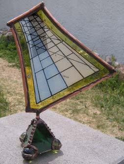
30 CHAPTER 7 CUBIC DIALS This booklet has in mind two cubic dials. The first is on the left and using the template, it works at any latitude provided the sub is tilted to the dial's latitude. It requires north south alignment. The second is below and to the right, the dial is typically designed for a latitude in so far as the horizontal and vertical dials are latitude specific. The meridian (east and west) dials are tilted so their equinox line is at the co-latitude. In all cases, if sunset data is to be displayed, then that makes the dial latitude dependant. The horizontal dial on top of the cube to the right, has been discussed and the reader is proficient in it's design. The vertical dial to the right is designed exactly as would be a horizontal dial however the co-latitude is used in place of the latitude. That only leaves the meridian dials which are on the east and west faces, which are common to both cube dials on this page, and the polar dial (the one facing the sun in the top picture) and the equatorial dial which is not visible in the top picture. The meridian dials (east and west) have the same design method that a polar dial has. Hour lines are always a distance from the gnomon base equal to the linear height of the gnomon multiplied by the trigonometric tangent of the product of the hour and 15. The 15 is because the sun rotates 15 degrees per hour. And the equatorial dials are nothing more than circles with hour lines every 15 degrees. 30


31 TOOLS AND SUPPLIES To the left are the materials, other than the templates, that make the dial. Some wood 4 by 4 beams are not true square, so check where the "bad" side is, and use that for a plate that will not have a dial face on it. Plexi-glass was used, clear contact paper can also be used however it is less durable. Below to the left are some tools. One is a metal protractor useful for marking the two pencil lines on the wooden block to help guide the trueness of the hole, namely at co-latitude. Three drill bits are helpful, a small one to drill the plexi-glass foe the nail gnomon, another for screws to hold the plexi-glass, and as a starter hole for the dowel, and a third for the holes in the cube and base for the dowel itself. A measuring device or micrometer is used to measure the wood block faces, and to measure the height of the gnomon nails whose length is on the template. If plexi-glass is used, remember to consider the thickness of plexi-glass. The snips are to cut the nails to the correct length. A utility knife is used to cut plexi-glass as well as the templates. Take care when using utility knives, they can cut the fingers and you may not know it until you see visible signs of human trauma. If the screws and nails are not brass, then be aware that a compass in close proximity may not be accurate. 31
32 TEMPLATE extracted FOR THE from FIRST the book CUBIC ILLUSTRATING DIAL Italian TIME S lines are SHADOW latitude specific 32
33 TEMPLATE extracted from FOR the THE book FIRST ILLUSTRATING CUBIC DIAL TIME S no Italian SHADOW lines 33
34 BUILDING THE FIRST CUBIC DIAL A cube of wood cut from a 4 by 4 inch beam is the cube. equatorial dial for the summer it is a circle this faces the sky towards the pole west facing meridian dial it looks like an early space capsule polar dial the one that looks like a bow tie and it faces the sun east facing meridian dial it looks like an early space capsule equatorial dial for the winter it is a circle this faces the ground towards the equator The template is cut and may be glued to the cube using Elmer's glue or even PVC pipe glue. Remember that glue fumes may be toxic. A base is cut from a 1 inch thick 4 by 4 inch beam. A hole is drilled in the base, and a hole in the cube. The hole in the cube is on the cube face that faces the pole and faces the ground. If it has anything on it, it would be just data, such as in the top left of the template on the preceding page. The cube polar dial facing the equator equatorial dial for summer east and west faces have meridian dials equatorial dial for winter A dowel co-latitude latitude The Base 34


35 The hole in the cube is at an angle, and to facilitate this, mark the east or west face with a line angled at co-latitude (90-latitude), and mark the equatorial face with a vertical line. Use a small drill first and have the drill match the co-latitude line and the vertical line. When that hole is finished, insert a nail or rod and check for true angles. Then use a bigger drill bit to make room for the dowel. Then attach the dial faces. They may be protected with clear contact paper or with plexi-glass which would be screwed t the cube faces. Then insert nails to be the nodus which functions as the entire gnomon. The height of the nail from the wood surface to the nail tip is shown on each dial template as a horizontal line. SO if you scale up or down the template, the gnomon length will change appropriately. Glue the cube to the dowel and the down to the base. You now have a dial reading local apparent time. Add or subtract the longitude correction, being 4 minutes per degree from the legal time meridian. Add the EOT factor, it is on the dial face, however a more complete table is in the appendices. The dial is now functional. BUILDING THE SECOND CUBIC DIAL The second dial has no complicated holes to drill at a special angle for latitude. The meridian dials can come from the prior template, that leaves just the horizontal dial to draft and an SIMPLE SHADOWS covers that. The vertical dial is nothing more than a horizontal dial but designed for the colatitude. QUESTIONS The gnomons are all nails, so, where is the style? The style is virtual, thus the nail length and position for the vertical and the horizontal dials are such that were a line extended from the nodus or tip to the dial center, then latitude would be apparent. Some data on the templates is latitude dependant, but the time is not, provided the instructions are followed. What is latitude dependant are the Italian hours, the lines showing the time until sunset, and, on the circular equatorial dials, the sunset and sunrise line is also latitude dependant. For full information on these refinements, please acquire Illustrating Time s Shadow! 35
36 APPENDIX - 1 TRIGONOMETRY AND GEOMETRY RULES Trigonometry has a set of functions that are defined that make working with angles and lines easy using simple mathematics. There are also certain truisms about the functions. Pythagoras's Theorem sqrt(hypotenuse)= sqrt(adjacent**2+ hypotenuse opposite opposite**2) angle Fig a.1 adjacent A right angles triangle has one angle that is 90 degrees, and the side opposite that angle is called the hypotenuse. For an angle other than the right angle, there are defined sides called the opposite side and the adjacent side. And there are some predefined functions, and tables that give you their values. And spreadsheets provide this service also, however a spreadsheet usually uses "radians" rather than the more common degrees. definitions: tan (angle ) = opposite /adjacent [tangent] sin (angle) = opposite / hypotenuse [sine] cos (angle) = adjacent / hypotenuse [cosine] and they are remembered with the sentence: "the old aunt, sat on her, coat and hat". The word "co" means complement of. So the cosine is the complement of the sine. cos (angle ) = sin (90 - angle ) And for the tangent some extra things are true cotan (angle ) = tan ( 90 - angle ) = 1 / tan ( angle ) is easily proved because 90-angle is the opposite angle and thus its tan is the old adjacent divided by the old opposite. Also you can deduce: tan (angle ) = sin (angle ) / cos (angle ) The angle whose sine is x is referred to as arcsin(x), similarly for arcos and arctan, or asin, acos, and atan. Sometimes the symbol sin -1 (value), cos -1, and tan -1 are used. 36
37 Geometry is the drawing of lines, arcs, circles and the like. It relates to trigonometry, however it can be used independently. Geometry can also use techniques such as rotating something on its side, such as a protractor on a gnomon, whereas doing that rotation in trigonometry would be much harder since it would involve three dimensions. Fig a.2 For example, above we see a protractor perpendicular to a plane and it has some angle marked. With geometry we can fold the protractor down to be in line with the plane which makes things much easier. Fig a.3 And these projections are very helpful in working out sundial problems. Where geometric methods were used, they were nothing more than rotations of planes by sometimes 90 degrees, sometimes by less. CAUTION: Some projections are not just 90 degree rotations. For example, in the horizontal dial, the gnomon is rotated 90 degrees first, and then a 90 degree line drawn from the nodus to the plate, and that is then rotated more than 90 degrees in effect, because the protractor's radius is the 90 degree line from the nodus and not the vertical dropped from the nodus to the dial plate. The protractor's radius comes from rotating the 90 degree projection of the style by 180 degrees - latitude But first the gnomon is rotated only 90 degrees. r r Fig a.4 37
38 TRIANGLES AND THINGS All normal (i.e. non spherical) triangles have angles that add up to 360 degrees, a right angled triangle has one angle of 90 degrees, and an isosoles triangles has two of the angles equal and thus less than 90 degrees, and an equilateral triangle has all three angles equal and they are 60 degrees each. CIRCLES AND THINGS A circle has a center, and the perimeter of the circle is a constant distance from the center, that distance is called the radius. The diameter is the distance between two points on the perimeter, or circumference, passing through the center, and is twice the length of the radius. The length of the perimeter, it's circumference, is:- circumference = 2 * * radius circumference = * diameter diameter radius circumference is the length of the perimeter. The number is called pi, symbol π, and occurs in many circular mathematical expressions. The circumference is divided up into degrees, degrees of arc, and there are 360 degrees in a circle, or 180 degrees in a semi-circle. Other measures are used, the next most common, especially when using spreadsheets, is the radian. There are 2 * pi, i.e. 2 *3.1416, or radians in a circle, so one radian is degrees. That strange number actually makes sense when it is found that the trigonometric functions of sin, cos, and tan are derived from series, and readily employ the radian. sin(x) = x (x**3)/3! + (x**5)/5! (x**7)/7! +... cos(x) = 1 (x**2)/2! + (x**4)/4! (x**6)/6! +... tan(x) = x + (x**3)/3 + 2*(x**5)/ atan(x) = x (x**3)/3 + (x**5)/5 (x**7)/ (no factorials) While the series shown above may not be used much in the normal course of life, they were what the author used back in the IBM 360 and early 370 days when developing font rotation logic using the floating point feature of the computer. The radius, diameter, and circumference formulae are helpful in armillary and equatorial dials "A 4.5 inch pipe cap-end was cut and used, the radius was thus 2.25 inches, being thusly the gnomon to dial plate distance. The hour lines are a simple 15 degrees, or *diameter/24, i.e *4.5/24 = inches apart. Useful when using CAD to draw a template." The symbol "!" is called a factorial, and is simply a string of multiplications from the number in question down to 1, thus 5! would be 5*4*3*2*1 or 120 if my arithmetic serves me well today. 38
39 TRIGONOMETRIC FUNCTIONS A1.1 degrees radians sin cos tan cotan degrees radians sin cos tan cotan inf
40 A2.1 APPENDIX 2 - Tables independent of location EQUATION OF TIME ~ EOT minutes:seconds mm.ss EQUATION OF TIME TABLE Jan Feb Mar Apr May Jun Jul Aug Sep Oct Nov Dec 1 3:09 13:34 12:17 3:49-2:54-2:09 3:51 6:17 0:02-10:21-16:21-10:52 2 4:07 13:42 12:05 3:32-3:01-1:59 4:03 6:13-0:22-10:40-16:22-10:29 3 4:34 13:48 11:52 3:14-3:07-1:50 4:14 6:08-0:41-10:59-16:22-10:06 4 5:02 13:54 11:39 2:57-3:13-1:39 4:25 6:03-1:01-11:17-16:22-9:42 5 5:28 13:59 11:26 2:39-3:18-1:29 4:35 5:57-1:21-11:35-16:20-9:17 6 5:55 14:03 11:12 2:22-3:23-1:18 4:45 5:51-1:41-11:53-16:18-8:52 7 6:21 14:06 10:58 2:06-3:27-1:07 4:55 5:43-2:01-12:10-16:15-8:27 8 6:46 14:09 10:43 1:49-3:30-0:56 5:04 5:36-2:22-12:27-16:11-8:00 9 7:11 14:10 10:28 1:33-3:33-0:44 5:13 5:27-2:43-12:43-16:06-7: :35 14:11 10:13 1:16-3:35-0:32 5:22 5:19-3:03-12:59-16:00-7: :59 14:12 9:57 1:01-3:37-0:20 5:30 5:09-3:24-13:15-15:54-6: :22 14:11 9:42 0:45-3:38-0:08 5:37 4:59-3:46-13:30-15:46-6: :44 14:10 9:25 0:30-3:39 0:04 5:44 4:48-4:07-13:44-15:38-5: :06 14:08 9:09 0:15-3:39 0:16 5:51 4:37-4:28-13:58-15:29-5: :27 14:05 8:52 0:00-3:38 0:29 5:57 4:26-4:49-14:12-15:19-4: :48 14:01 8:35-0:13-3:37 0:42 6:03 4:13-5:11-14:25-15:09-4: :08 13:57 8:18-0:27-3:36 0:55 6:08 4:01-5:32-14:37-14:57-3: :27 13:52 8:01-0:40-3:34 1:08 6:13 3:48-5:53-14:49-14:45-3: :45 13:47 7:43-0:53-3:31 1:21 6:17 3:34-6:15-15:00-14:31-2: :03 13:40 7:25-1:06-3:27 1:34 6:20 3:20-6:36-15:10-14:17-2: :20 13:33 7:08-1:18-3:24 1:47 6:23 3:05-6:57-15:20-14:02-1: :36 13:26 6:50-1:30-3:19 2:00 6:26 2:50-7:18-15:29-13:47-1: :52 13:18 6:32-1:41-3:14 2:13 6:28 2:34-7:39-15:38-13:30-0: :06 13:09 6:14-1:52-3:09 2:26 6:29 2:18-8:00-15:46-13:13-0: :20 13:00 5:56-2:03-3:03 2:39 6:30 2:02-8:21-15:53-12:55 0: :33 12:50 5:37-2:12-2:57 2:51 6:30 1:45-8:41-15:59-12:36 0: :45 12:39 5:19-2:22-2:50 3:04 6:29 1:28-9:02-16:05-12:17 1: :57 12:28 5:01-2:31-2:43 3:16 6:28 1:10-9:22-16:09-11:57 1: :07 4:43-2:39-2:35 3:28 6:26 0:52-9:42-16:14-11:36 2: :17 4:25-2:47-2:27 3:40 6:24 0:34-10:01-16:17-11:14 2: :26 4:07-2:18 6:21 0:16-16:19 3:03 If "+" then add to solar time to get mean time as the sun is slow. If " " then subtract from solar time to get mean time as the sun is fast. Some tables have a plus for our minus and vice versa. If in doubt look at the figure of eight equation of time. Formulae involving dates use approximations thus these tables may disagree with other sources using other formulae. This and other publications have figures that are well within drafting tolerances. 40
41 EOT (decimal mm.ss) AVERAGE FOR MONTH (2 sine wave formula) A2.1b mm.ss Jan Feb Mar Apr May Jun Jly Aug Sep Oct Nov Dec avg EOT (decimal mm.ss) AVERAGE FOR MONTH WITH LONGITUDE CORRECTIONS FOR DIAL PORTABILITY A2.1c Month Jan Feb Mar Apr May Jun Jly Aug Sep Oct Nov Dec Long Diff EAST OF TIME ZONE WEST OF TIME ZONE Rather than make hour lines and their angles conform to the dial's location, it may be wiser to have an equation of time incorporating the longitude difference. This facilitates dial portability. Since time zones tend to be 7.5 degrees wide, a table is provided to cover that longitude span. LAT (local apparent time) + EOT eg: + longitude correction + 1 if it is LEGAL or solar time as shown on Nov 15 if E of legal meridian summer STANDARD the dial Feb if west of it MEAN TIME is what you see gets local gets legal standard time mean time Tables A2.1b and A2.1c use a two sine wave formula which differs from table A2.1 which is why their figures differ. When using any EOT values, always know what they indicate, their sign, and what assumptions have been made. 41
42 A2.3 LONGITUDE TO TIME Degree ( ) to Hours (h) and Minutes (m) hh.mm hh.mm hh.mm hh.mm hh.mm hh.mm
43 A2.5 CITY DATA WITH LATITUDE, LONGITUDE AND ITS CORRECTION City Country, State, City Hemi- Lat Long Mag Time Long id sphere +n -s +w -e var ref corr UK London N +ve w 0 2 UK Weymouth N +ve w 0 10 PHX USA AZ Phoenix N +ve e SDL USA AZ Scottsdale N +ve e LAX USA CA Los Angeles N +ve e SAN USA CA San Diego N +ve e SFO USA CA San Fransisco N +ve e DEN USA CO Denver N +ve e DCA USA DC Washington N +ve w 75 8 CHI USA IL Chicago, N +ve w SVC USA NM Silver City N +ve e LAS USA NV Las Vegas N +ve e JFK USA NY New York N +ve w OKC USA OK Oklahoma City N +ve e ELP USA TX El Paso N +ve e DAYLIGHT SAVING TIME AND TABLE OF TIME ZONES Zone Name Meridian GMT+ Newfoundland Atlantic Eastern Central Mountain Pacific Yukon Alaska-Hawaii Bering GMT Greenwich Mean Time 0 BST British Summer Time -1 IST Irish Summer Time -1 WET Western Europe Time 0 WEST Western Europe Summer Time -1 CET Central Europe Time -1 CEST Central Europe Summer Time -2 EET Eastern Europe Time -2 EEST Eastern Europe Summer Time -3 MSK Moscow Time -3 MSD Moscow Summer Time -4 A2.6 SUMMER TIME RULES note: the USA may change its baseline dates in upcoming years. USA: EU: first Sunday of April to the last Sunday of October. (some exceptions e.g. AZ, HI, etc) last Sunday in March to the last Sunday in October. The website: has other useful information. 43
44 MAGNETIC DECLINATION & VARIATION mag 0 0 For the visually inclined, or for those who get confused at times with adding and subtracting magnetic variation (pilots and seamen call it variation) or magnetic declination (solar enthusiasts call it this), here are some diagrams aimed at simplifying the task true Identify the magnetic bearing, for example 096 measured on a compass where the variation is 11 degrees east. 096 degrees on the outer scale is 108 degrees on the inner scale Fig a2.7 Magnetic variation is 11 degrees East If the variation is easterly, ADD the variation to the magnetic bearing, and if the results is more than 360 degrees, subtract 360. mag 0 Identify the magnetic bearing, for example 005 measured on a compass where the variation is 11 degrees west true degrees on the outer scale is 354 degrees on the inner scale If the variation is westerly, SUBTRACT the variation from the magnetic bearing, and if the results is more than 360 degrees, subtract 360. Fig a Magnetic variation is 11 degrees West You may consider drawing some protractors or rulers for your location, you may copy the two rulers below, cut them and slide them to show the magnetic declination
45 APPENDIX 3 A3.1 a TABLES THAT CONSIDER LOCATION HORIZONTAL (AND VERTICAL DIAL) HOUR LINE ANGLES HOUR LINE ANGLES Horizontal dial hour angle DEGREES(ATAN(TAN(RADIANS(15*time))*SIN(RADIANS(lat)))) hour angle H = atan ( sin(lat) * tan (ha) ) HORIZONTAL DIAL LATITUDE TIME noon VERTICAL DIAL LATITUDE NOTE: Values are degrees and tenths and hundredths of a degree. Thus latitude 39 at 1pm or 11am shows 9.57 degrees, not 9 degrees, 57 minutes. And 9.57 degrees converts to 9 degrees 34.2 minutes of arc, which is consistent with other publications. 45
46 A3.1 b HOUR LINE ANGLES Horizontal dial hour angle DEGREES(ATAN(TAN(RADIANS(15*time))*SIN(RADIANS(lat)))) hour angle H = atan ( sin(lat) * tan (ha) ) HORIZONTAL DIAL LATITUDE TIME noon VERTICAL DIAL LATITUDE 46
47 A3.1 c HOUR LINE ANGLES Horizontal dial hour angle DEGREES(ATAN(TAN(RADIANS(15*time))*SIN(RADIANS(lat)))) hour angle H = atan ( sin(lat) * tan (ha) ) HORIZONTAL DIAL LATITUDE TIME noon VERTICAL DIAL LATITUDE 47
48 APPENDIX 6 SUNRISES AND SUNSETS Almanacs are online or can be purchased, and The Old Farmer's Almanac also has sunrise and sunset times. These are accurate ways of determining when the sun wakes up or goes to sleep. However, other methods exist, may be less accurate, maybe quaint, maybe using different definitions of sunrise, yet each of interest. A formula can be used, and the formula sequence below is very close to almanac accurate. First calculate the "day angle" (in radians, an intermediate figure), [j = Julian day] da = 2 * pi * ( j-1 ) / 365 Next calculate the "Sun Declination" decl = degrees ( *cos(da) *sin(da) *cos(2*da) *sin(2*da) *cos(3*da) *sin(3*da) Then calculate the "Azimuth of rising/setting sun" A = arccos ( sin(decl) / cos(lat) ) [or =180- arccos ( sin(decl) / cos(lat) )] And finally the "Hour angle of rising/setting sun" from noon hsr = arccos( tan(lat) * tan(decl) ) This needs longitude and EOT correction. The web site: ha some spreadsheets that have many of the tables here in Excel downloadable form. And because Open Office (free and almost compatible with Excel) is not fully compatible with Excel, there is a set of Open Office sheets as well. 48
49 LOCAL APPARENT TIME OF SUNRISE AND SUNSET for the solstices. It is 6am and 6pm for the equinoxes. Local apparent solar time of sunrise and sunset. Times are hh.mm Solstice Sunrise and Sunset (equinox is 6am/pm). No longitude correction. No EOT correction. Winter solstice: Declination: Summer solstice: Declination: Lat Rise Set Day hrs Lat Rise Set Day hrs Sunset (true time or local apparent time) occurs the same number of hours after noon that sunrise happens before. An 0605 sunrise is 5 hours 55 minutes before noon, thus sunset is 5 hours 55 minutes after it, or Except for on the hour or half hour, the minutes do not match. For standard time, then the time is shifted by the longitude correction and then by the equation of time, thus the March and September equinoxes do not match due to differing EOT values. 49
50 APPENDIX 8 - COLLECTION OF FORMULAE INCONSISTENCIES AND APPARENT INCONSISTENCIES FORMULAE CONVERTED FOR A SPREADSHEET SUNS DECLINATION FOR ANY GIVEN DAY OF THE YEAR Day number, J J=1 on 1 January, J=365 on 31 December. February is taken to have 28 days. Jan Feb Mar Apr May Jun Jly Aug Sep Oct Nov Dec Day angle: Sun Declination: da = 2 * pi * ( j-1 ) / 365 (in radians, is an intermediate figure) decl = degrees ( *cos(da) *sin(da) *cos(2*da) *sin(2*da) *cos(3*da) *sin(3*da) SUNS ALTITUDE AND AZIMUTH ON ANY GIVEN HOUR GIVEN THE SUNS DECLINATION ALTITUDE: The sun's altitude is its angle when looked at face on in degrees alt = degrees( ASIN( SIN(decl) * SIN(lat) + COS(decl) * COS(lat)*COS(lha) ) ) The suns azimuth: azi = ATAN( SIN(lha) / ( (SIN(lat) * COS(lha)) [human] (COS(lat) * TAN(decl))) SUNRISE AND SUNSET TIME FORMULA azi = degrees(atan(sin(radians(15*(12-(hour/100))))/ (sin(radians(lat))*cos(radians(15*(12-(hour/100))))- tan(radians(decl))*cos(radians(lat))))) [spreadsheet] Azimuth of rising/setting sun: A = 180 arccos ( sin(decl) / cos(lat) ) Hour angle of rising/setting sun: hsr = arccos( tan(lat) * tan(decl) ) from noon HORIZONTAL DIAL HOUR LINE ANGLE H = atan ( sin(lat) * tan (lha) ) EQUATION OF TIME A formula derived from Frans Maes from data by Savoie producing the EOT in minutes and using two sine waves is used for some spreadsheets, e.g. A2.1b, A2.1c. The values in the sin(...) function result in radians, so the formula is spreadsheet ready as-is. Value d = 1 to 365 E = -7.36*sin(2*3.1416*(d-4.21)/365) *sin(4*3.1416*(d-9.9)/365) STANDARD TIME FROM LAT (Local Apparent Time) legal time = LAT + EOT.corr + west.long.corr + 1 if summer or standard east.long.corr time 50
51 A DRAFTING SHEET FOR HORIZONTAL DIALS 51
52 SOFTWARE OF INTEREST TO THE DIALIST SHADOWS most comprehensive, license is reasonable and free version covers many common needs SUNSET sunset.xls good sunrise and sunset calculator SUNTIMES program has a world map and sun times If you download an almanac, remember that you must still correct it for longitude. There are some very good spreadsheets that calculate sunrise and sunset times that are free. OTHER USEFUL SOFTWARE [low cost and free spreadsheet] [low cost and free CAD 2d] ESSENTIAL WEB RESOURCES US and UK Societies have English Language web sites SOURCES OF FORMULAE the book ILLUSTRATING TIME S SHADOW, ALMANACS Misc Almanacs [freeware downloadable] [freeware downloadable] REFERENCE WORDS longitude the meridian identifying the left right position on the earth, see latitude. meridian a line running through both poles and the observer at noon. latitude the up down position on the earth, the angle is measured from the equator. equator the circle that slices the earth in two, perpendicular to the polar axis. polar axis the central line around which the earth rotates equation of time the correction to make sun time match modern watches ecliptic the earth's orbit around the sun, 23.5 degrees off from the equator. 52


53 Some of the author's demonstration sun dials THE DIFFERING SUN DIAL TYPES ALTITUDE DIALS AZIMUTH DIALS HOUR ANGLE DIALS Capuchin Equatorial Dial Analemmatic Shepherd Armillary dial Winged Ogee Polar dial Vertical dial Horizontal dial photo taken from above the dial Meridian dial 53


54 Please consider acquiring "ILLUSTRATING TIME S SHADOW" ~ How to make Sundials for almost anywhere using empirical, geometric, and trigonometric methods as well as computer aided design and spreadsheets. Cubic Shadows How to make a CUBIC sun dial for the common latitudes of the planet earth Simon Wheaton-Smith ISBN ISBN
SIMPLE Shadows. How to make a simple horizontal sun dial for your latitude. And, how and why they work.
 SIMPLE Shadows How to make a simple horizontal sun dial for your latitude. And, how and why they work. Simon Wheaton-Smith July 2016 SIMPLE Shadows TABLE OF CONTENTS Introduction Get Started BUILD IT FIRST
SIMPLE Shadows. for smartphones. Simon Wheaton-Smith October 2012 COOK BOOK FORMAT AND SOME THEORY
 SIMPLE Shadows for smartphones How to make a simple horizontal sun dial And, how and why they work. condensed from the full version of this book COOK BOOK FORMAT AND SOME THEORY Simon Wheaton-Smith October
CUTTING Shadows SOME CUTOUT DIALS FOR YOUR AMUSEMENT. ALL YOU NEED ARE SOME SCISSORS, AND YOUR LATITUDE, AND LONGITUDE.
 CUTTING Shadows SOME CUTOUT DIALS FOR YOUR AMUSEMENT. ALL YOU NEED ARE SOME SCISSORS, AND YOUR LATITUDE, AND LONGITUDE. Simon Wheaton-Smith December 2009 CUTOUTS FOR PAPER SUN DIALS armillary (also equatorial
One sine wave is 7.64 minutes peak to peak variation. Two sine waves is 9.86
 WHY THE SUN IS SOMETIMES FAST AND SOMETIMES SLOW As the earth orbits the sun in an ellipse, it goes faster approaching the sun and slower when receding, just like when you throw a ball up in the air and
ANALEMMAS. on the gnomon and on the dial plate. Declining Shadows (Declining-Shadows.pdf ) for declination curve insights and methods.
 for declination curve insights and methods.") ANALEMMAS on the gnomon and on the dial plate armillary dials equatorial dials horizontal and vertical dials also and vertical decliners and polar and meridian please read: NOTE: using these: also see:
ANALEMMAS on the gnomon and on the dial plate armillary dials equatorial dials horizontal and vertical dials also and vertical decliners and polar and meridian please read: NOTE: using these: also see:
ILLUSTRATING SHADOWS TABLE OF CONTENTS
 ILLUSTRATING SHADOWS TABLE OF CONTENTS 316 pages Introduction Chapter Page Introduction and "A Quick Hands On Project" Part One 1 10 The approximate evolution of the dial 2 13 How the earth does its thing
Polar Sundial. Cut carefully on this line. Cut on this line.
 1 The Sundial Primer - "Dialling Guides" The purpose of the "Dialling Guides" is to provide an easy method for laying out the hour lines for a number of polar sundials located at any latitude in either
 June 15, 2006 July 19, 2009 A south facing vertical declining sundial by a barn in, Silver City, NM Using a trigon and empirical methods, and a gnomon whose sub-style was vertical True N Magnetic N Silver
For most observers on Earth, the sun rises in the eastern
 632 CHAPTER 25: EARTH, SUN, AND SEASONS WHAT IS THE SUN S APPARENT PATH ACROSS THE SKY? For most observers on Earth, the sun rises in the eastern part of the sky. The sun reaches its greatest angular altitude
Earth Motions Packet 14
 Earth Motions Packet 14 Your Name Group Members Score Minutes Standard 4 Key Idea 1 Performance Indicator 1.1 Explain complex phenomena, such as tides, variations in day length, solar insolation, apparent
THE PLANISPHERIC ASTROLABE
 THE PLANISPHERIC ASTROLABE Feb 4, 2006 A half Dinar note from Iraq with an astrolabe portrayal Of old, the astrolabe was used for various astronomical and astrological calculations, In particular, it could
Lesson 20: The Earth in its Orbit
 291 Lesson 20: The Earth in its Orbit Recall that the Earth s orbit around the un is an ellipse which is almost a perfect circle. The average distance from the un to the Earth is 152,100,000 km (to the
PHOENIX ARIZONA. Various sundials. This space left blank intentionally. Latitude: 33.5 Longitude: Legal: 105 Magnetic Var/Decl:
 PHOENIX ARIZONA Latitude: 33.5 Longitude: 112.1 Legal: 105 Magnetic Var/Decl: City Country, State, City Hemi- Latitude Long Mag Time Long id sphere +n -s +w -e dec/var ref corr PHX USA AZ Phoenix N +ve
The Earth-Moon-Sun System
 chapter 7 The Earth-Moon-Sun System section 2 Time and Seasons What You ll Learn how to calculate time and date in different time zones how to distinguish rotation and revolution what causes seasons Before
2. Modern: A constellation is a region in the sky. Every object in the sky, whether we can see it or not, is part of a constellation.
 6/14 10. Star Cluster size about 10 14 to 10 17 m importance: where stars are born composed of stars. 11. Galaxy size about 10 21 m importance: provide a stable environment for stars. Composed of stars.
The Sundial Primer - "Dialling Guides" Double Gnomon Polar Sundial
 1 Double Polar Sundial he purpose of the "Dialling Guides" is to provide an easy method for laying out the hour lines for a number of double gnomon polar sundials located at any latitude in either the
Introduction To Modern Astronomy I: Solar System
 ASTR 111 003 Fall 2007 Lecture 02 Sep. 10, 2007 Introduction To Modern Astronomy I: Solar System Introducing Astronomy (chap. 1-6) Planets and Moons (chap. 7-15) Chap. 16: Our Sun Chap. 28: Search for
Sundials and the Celestial Sphere. Katie Hausknecht
 Sundials and the Celestial Sphere Katie Hausknecht What is a sundial? A sundial is a device that uses the shadow cast by the sun to indicate what time of day it is, often by hours. The Celestial Sphere
Chapter S1 Celestial Timekeeping and Navigation. How do we define the day, month, year, and planetary time periods?
 Chapter S1 Celestial Timekeeping and Navigation S1.1 Astronomical Time Periods Our goals for learning:! How do we define the day, month, year, and planetary time periods?! How do we tell the time of day?!
Discovering the Night Sky
 Discovering the Night Sky Guiding Questions 1. What role did astronomy play in ancient civilizations? 2. Are the stars that make up a constellation actually close to one another? 3. Are the same stars
Discovering the Night Sky
 Guiding Questions Discovering the Night Sky 1. What role did astronomy play in ancient civilizations? 2. Are the stars that make up a constellation actually close to one another? 3. Are the same stars
Knowing the Heavens. Chapter Two. Guiding Questions. Naked-eye (unaided-eye) astronomy had an important place in ancient civilizations
 astronomy had an important place in ancient civilizations") Knowing the Heavens Chapter Two Guiding Questions 1. What role did astronomy play in ancient civilizations? 2. Are the stars that make up a constellation actually close to one another? 3. Are the same
Knowing the Heavens Chapter Two Guiding Questions 1. What role did astronomy play in ancient civilizations? 2. Are the stars that make up a constellation actually close to one another? 3. Are the same
Chapter 4 Earth, Moon, and Sky 107
 Chapter 4 Earth, Moon, and Sky 107 planetariums around the world. Figure 4.4 Foucault s Pendulum. As Earth turns, the plane of oscillation of the Foucault pendulum shifts gradually so that over the course
R.L. Kellogg, Ph.D. North American Sundial Society June 2013
 R.L. Kellogg, Ph.D. North American Sundial Society June 2013 1 Analemmatic Sundials The Human Sundial The Analemmatic Sundial or Human Sundial was first described by M. de Vaulezard in 1640 in a Treatise
PHAS 1511: Foundations of Astronomy
 PHAS 1511: Foundations of Astronomy Dr Roger Wesson Research interests: deaths of stars. Planetary nebulae, novae and supernovae. Astronomy: some maths You can see that distances in astronomy are huge.
3. The Sun s Position
 3. The Sun s Position In order to understand how to collect energy from the sun, one must first be able to predict the location of the sun relative to the collection device. In this chapter we develop
5 - Seasons. Figure 1 shows two pictures of the Sun taken six months apart with the same camera, at the same time of the day, from the same location.
 ASTR 110L 5 - Seasons Purpose: To plot the distance of the Earth from the Sun over one year and to use the celestial sphere to understand the cause of the seasons. What do you think? Write answers to questions
Time, Seasons, and Tides
 Time, Seasons, and Tides Celestial Sphere Imagine the sky as a great, hollow, sphere surrounding the Earth. The stars are attached to this sphere--- some bigger and brighter than others--- which rotates
Astronomy 291. Professor Bradley M. Peterson
 Astronomy 291 Professor Bradley M. Peterson The Sky As a first step, we need to understand the appearance of the sky. Important points (to be explained): The relative positions of stars remain the same
Before you Sit. Please Pick-up: Blue Information Sheet for Evening Observing. 1 Red and 1 Blue ticket for Observing/ Planetarium
 Before you Sit Please Pick-up: Blue Information Sheet for Evening Observing. 1 Red and 1 Blue ticket for Observing/ Planetarium Evening Observing Observing at the Brooks Observatory: Three different weeks
C) the seasonal changes in constellations viewed in the night sky D) The duration of insolation will increase and the temperature will increase.
 the seasonal changes in constellations viewed in the night sky D) The duration of insolation will increase and the temperature will increase.") 1. Which event is a direct result of Earth's revolution? A) the apparent deflection of winds B) the changing of the Moon phases C) the seasonal changes in constellations viewed in the night sky D) the
1. Which event is a direct result of Earth's revolution? A) the apparent deflection of winds B) the changing of the Moon phases C) the seasonal changes in constellations viewed in the night sky D) the
ZW2000 and Your Sundial
 1 The Sundial Primer created by At this point I assume that you have downloaded and set up ZW2000 on your computer. If not please read Getting Started with ZW2000. Initiate the program ZW2000. Figure 1
Exercise 6. Solar Panel Orientation EXERCISE OBJECTIVE DISCUSSION OUTLINE. Introduction to the importance of solar panel orientation DISCUSSION
 Exercise 6 Solar Panel Orientation EXERCISE OBJECTIVE When you have completed this exercise, you will understand how the solar illumination at any location on Earth varies over the course of a year. You
ClassAction: Coordinates and Motions Module Instructor s Manual
 ClassAction: Coordinates and Motions Module Instructor s Manual Table of Contents Section 1: Warm-up Questions...3 The Sun s Path 1 4 Section 2: General Questions...5 Sledding or Going to the Beach...6
Geography Class 6 Chapters 3 and
 CHAPTER 3 MOTIONS OF THE EARTH The Earth is always travelling in Space. That makes each person on Earth, a Space Traveller. No one feels the movement of the Earth because humans are too tiny when compared
CA1 2.11: Designing an Equatorial Sundial Activity
 Purpose: To design an equatorial sundial and learn about motions of the sun and earth that have a bearing on its design. Materials: poster board, length of stiff wire or dowel rod, tape, protractor, ruler,
LAB 3: THE SUN AND CLIMATE NAME: LAB PARTNER(S):
:") GEOG 101L PHYSICAL GEOGRAPHY LAB SAN DIEGO CITY COLLEGE SELKIN 1 LAB 3: THE SUN AND CLIMATE NAME: LAB PARTNER(S): The main objective of today s lab is for you to be able to visualize the sun s position
GEOG 101L PHYSICAL GEOGRAPHY LAB SAN DIEGO CITY COLLEGE SELKIN 1 LAB 3: THE SUN AND CLIMATE NAME: LAB PARTNER(S): The main objective of today s lab is for you to be able to visualize the sun s position
Chapter S1 Lecture. The Cosmic Perspective Seventh Edition. Celestial Timekeeping and Navigation Pearson Education, Inc.
 Chapter S1 Lecture The Cosmic Perspective Seventh Edition Celestial Timekeeping and Navigation 2014 Pearson Education, Inc. Celestial Timekeeping and Navigation 2014 Pearson Education, Inc. S1.1 Astronomical
Meridian Circle through Zenith, North Celestial Pole, Zenith Direction Straight Up from Observer. South Celestial Pole
 Chapter 3 How Earth and Sky Work- Effects of Latitude In chapters 3 and 4we will learn why our view of the heavens depends on our position on the Earth, the time of day, and the day of the year. We will
Astronomy 101: 9/18/2008
 Astronomy 101: 9/18/2008 Announcements Pick up a golf ball at the front of the class or get one from Alex; you will need it for an in-class activity today. You will also need the question sheet from Alex.
The Sun-Earth-Moon System
 chapter 311 section 1 Earth The Sun-Earth-Moon System Before You Read What do you already know about Earth s shape, its size, and how it moves? Write what you know on the lines below. What You ll Learn
ZW2000 and Your Vertical Sundial Carl Sabanski
 1 The Sundial Primer created by At this point I assume that you have downloaded and set up ZW2000 on your computer and have also read the overview document. If not please read Getting Started with ZW2000
CELESTIAL COORDINATES
 ASTR 1030 Astronomy Lab 27 Celestial Coordinates CELESTIAL COORDINATES GEOGRAPHIC COORDINATES The Earth's geographic coordinate system is familiar to everyone - the north and south poles are defined by
b. So at 12:00 p.m., are the shadows pointing in the direction you predicted? If they are not, you must explain this observation.
 Astronomy 100 Name(s): Exercise 2: Timekeeping and astronomy The following exercise illustrates some basic ideas about time, and how our position in the solar system uniquely configures the measurement
The following terms are some of the vocabulary that students should be familiar with in order to fully master this lesson.
 Lesson 211: EARTH'S SEASONS Students learn the complex geometry and planetary motions that cause Earth to have four distinct seasons. Fundamental Questions Attempting to give thorough and reasonable answers
6/17. Universe from Smallest to Largest:
 6/17 Universe from Smallest to Largest: 1. Quarks and Leptons fundamental building blocks of the universe size about 0 (?) importance: quarks combine together to form neutrons and protons. One of the leptons
The celestial sphere, the coordinates system, seasons, phases of the moon and eclipses. Chapters 2 and S1
 The celestial sphere, the coordinates system, seasons, phases of the moon and eclipses Chapters 2 and S1 The celestial sphere and the coordinates system Chapter S1 How to find our way in the sky? Let s
Astronomy 122 Section 1 TR Outline. The Earth is Rotating. Question Digital Computer Laboratory
 Astronomy 122 Section 1 TR 1300-1350 Outline 1320 Digital Computer Laboratory Leslie Looney Phone: 244-3615 Email: lwlw@wuiucw. wedu Office: Astro Building #218 Office Hours: T 10:30-11:30 a.m. or by appointment
What Is the Relationship Between Earth s Tilt and the Seasons?
 Learning Set 2 Why Are There Differences in Temperature? Review Images and Graphics While reading about Earth s tilt and the seasons, pay particular attention to the graphics included. How do they help
HOW TO TRAVEL ON EARTH WITHOUT GETTING LOST
 HOW TO TRAVEL ON EARTH WITHOUT GETTING LOST Using a globe to learn how a position on Earth can be described. Rui Dilão, Instituto Superior Técnico Curriculum topic latitude, longitude, coordinate system
Lecture 2: Motions of the Earth and Moon. Astronomy 111 Wednesday August 30, 2017
 Lecture 2: Motions of the Earth and Moon Astronomy 111 Wednesday August 30, 2017 Reminders Online homework #1 due Monday at 3pm Labs start next week Motions of the Earth ASTR111 Lecture 2 Observation:
18.2 Earth Cycles Days and years Calendars Years and days Leap years Calendars throughout human history 20,000 years ago. 7,000 BC. 4,000 BC.
 18.2 Reading 18.2 Earth Cycles Do you ever wonder where our calendar comes from? Or why the Moon gradually changes its shape? Or why we have seasons? The answers have to do with the relative positions
MOTIONS OF THE EARTH. Figure 3.1 : Inclination of the Earth s axis and the orbital plane. Figure 3.2 : Day and Night on the Earth due to rotation
 3 Let s Do Take a ball to represent the earth and a lighted candle to represent the sun. Mark a point on the ball to represent a town X. Place the ball in such a way that the town X is in darkness. Now
6 The Orbit of Mercury
 6 The Orbit of Mercury Name: Date: Of the five planets known since ancient times (Mercury, Venus, Mars, Jupiter, and Saturn), Mercury is the most difficult to see. In fact, of the 6 billion people on the
Practice Questions: Seasons #1
 1. Seasonal changes on Earth are primarily caused by the A) parallelism of the Sun's axis as the Sun revolves around Earth B) changes in distance between Earth and the Sun C) elliptical shape of Earth's
Earth & Space Science, Interpreting Data DURATION Preparation: 5 minutes Activity: 40 minutes (total over one day)
") Objectives In this activity students will: 1. Observe how the position of the sun in the sky changes during the course of the day 2. Discover the cardinal directions by tracking the motion of the sun Materials
Objectives In this activity students will: 1. Observe how the position of the sun in the sky changes during the course of the day 2. Discover the cardinal directions by tracking the motion of the sun Materials
THE EARTH AND ITS REPRESENTATION
 UNIT 7 THE EARTH AND ITS REPRESENTATION TABLE OF CONTENTS 1 THE EARTH AND THE SOLAR SYSTEM... 2 2 THE EARTH S MOVEMENTS... 2 2.1 Rotation.... 2 2.2 The revolution of the Earth: seasons of the year....
Seasons ASTR 101 2/12/2018
 Seasons ASTR 101 2/12/2018 1 What causes the seasons? Perihelion: closest to Sun around January 4 th Northern Summer Southern Winter 147 million km 152 million km Aphelion (farthest to Sun) around July
Exercise 7.0 THE CHANGING DIURNAL CIRCLES OF THE SUN
 Exercise 7.0 THE CHANGING DIURNAL CIRCLES OF THE SUN I. The Apparent Annual Motion of the Sun A star always rises and sets at the same place on the horizon and, hence, it is above the horizon for the same
LESSON PLAN - Optimum Orientation of Solar Panels Using Soltrex Data
 LESSON PLAN - Optimum Orientation of Solar Panels Using Soltrex Data Title of Lesson: Optimum Orientation of Solar Panels Using Soltrex Data Description of class: High School physics, astronomy, or environmental
TILT, DAYLIGHT AND SEASONS WORKSHEET
 TILT, DAYLIGHT AND SEASONS WORKSHEET Activity Description: Students will use a data table to make a graph for the length of day and average high temperature in Utah. They will then answer questions based
Making a Sundial. Build a sundial and discover how time can be measured. Space Awareness, Leiden Observatory. iau.org/astroedu
 Making a Sundial Build a sundial and discover how time can be measured. Space Awareness, Leiden Observatory Age 6-10 Supervised Unsupervised Core skills Asking questions, Developing and using models, Analysing
It s Full of Stars! Outline. A Sky Full of Stars. Astronomy 210. lights), about how many stars can we see with
, about how many stars can we see with") Astronomy 210 Section 1 MWF 1500-1550 134 Astronomy Building Leslie Looney Phone: 244-3615 Email: lwlw@wuiucw. wedu Office: Astro Building #218 Office Hours: MTF 10:30-11:30 a.m. or by appointment This
Astronomy 210 Section 1 MWF 1500-1550 134 Astronomy Building Leslie Looney Phone: 244-3615 Email: lwlw@wuiucw. wedu Office: Astro Building #218 Office Hours: MTF 10:30-11:30 a.m. or by appointment This
Compendium* A Mean Time Sundial by Hendrik Hollander
 Volume 3 Number ISSN 074-397 (printed) ISSN 074-8059 (digital) June 006 The Journal of the North American Sundial Society Compendium* A Mean Time Sundial by Hendrik Hollander Time and reflection change
Lab: Constructing a Sundial PRACTICAL PHYSICS
 Name Date Period Lab: Constructing a Sundial PRACTICAL PHYSICS Background: As the earth turns on its axis, the sun appears to move across our sky. The shadows cast by the sun move in a clockwise (hence
SOLAR ENERGY: THAT S HOT Grades 4-6
 NJCCCS: 5.1, 5.2, 5.4 SOLAR ENERGY: THAT S HOT Grades 4-6 Field Trip Overview: This program illuminates the various ways in which our nearest star affects life on Earth. Students will learn about the apparent
The time they chose was the Vernal Equinox of March 20, 2000, at 7:30 AM Greenwich Mean Time (GMT). Right Ascension Offset
. Right Ascension Offset") Star Coordinates and the Celestial Dome Astronomers have mapped out the sky in the shape of a spherical dome the Celestial Sphere, where earth is just a tiny spec at the center of the dome. The celestial
Star Coordinates and the Celestial Dome Astronomers have mapped out the sky in the shape of a spherical dome the Celestial Sphere, where earth is just a tiny spec at the center of the dome. The celestial
Astronomy 100 Section 2 MWF Greg Hall
 Astronomy 100 Section 2 MWF 1200-1300 100 Greg Hall Leslie Looney Phone: 217-244-3615 Email: lwl @ uiuc. edu Office: Astro Building #218 Office Hours: MTF 10:30-11:30 a.m. or by appointment Class Web Page
Venus Project Book, the Galileo Project, GEAR
 1 Venus Project Book, the Galileo Project, GEAR Jeffrey La Favre November, 2013 Updated March 31, 2016 You have already learned about Galileo and his telescope. Recall that he built his first telescopes
Full Moon. Phases of the Moon
 Phases of the Moon The Moon takes 29.5 days to orbit Earth. This is a lunar month. The gravity of the Earth keeps the Moon in orbit. The Moon does not produce light. We see the Moon because it reflects
Which Earth latitude receives the greatest intensity of insolation when Earth is at the position shown in the diagram? A) 0 B) 23 N C) 55 N D) 90 N
 0 B) 23 N C) 55 N D) 90 N") 1. In which list are the forms of electromagnetic energy arranged in order from longest to shortest wavelengths? A) gamma rays, x-rays, ultraviolet rays, visible light B) radio waves, infrared rays, visible
1. In which list are the forms of electromagnetic energy arranged in order from longest to shortest wavelengths? A) gamma rays, x-rays, ultraviolet rays, visible light B) radio waves, infrared rays, visible
Eclipses. Solar and Lunar
 Eclipses Solar and Lunar An eclipse occurs when one body comes between the sun and a nearby body such that the shadow of one falls on the other. A total eclipse is when one body is seen completely occluded
Gnomon (a thin, round stick at least a foot long and capable of being put into the ground or stood up vertically)
") Name: Partner(s): Lab #3 Celestial Navigation Due 7/2 Objectives In this lab you will take measurements of the sun s motion around noon and the north star s position in the sky. You will use this data
Name: Partner(s): Lab #3 Celestial Navigation Due 7/2 Objectives In this lab you will take measurements of the sun s motion around noon and the north star s position in the sky. You will use this data
3. a. In the figure below, indicate the direction of the Sun with an arrow.
 Astronomy 100, Fall 2005 Name(s): Exercise 2: Seasons in the sun The following exercise illustrates some basic ideas about time, and how our position in the solar system uniquely configures the measurement
Daily Motions. Daily Motions. Solar and Sidereal Days. Annual Motions of the Sun. Coordinate system on Earth. Annual Motion of the Stars.
 Sun: rises in the east sets in the west travels on an arc across the sky 24 hours Daily Motions Solar Day = 24 hours Stars: stars travel on arcs in the sky moving from east to west. some stars rise and
Admin. 8/29/17. If you re at North Pole, you ll NEVER see stars that are below your horizon. Key Concepts: Lecture 4
 Admin. 8/29/17 1. Class website http://www.astro.ufl.edu/~jt/teaching/ast1002/ 2. Optional Discussion sections (start Aug. 30th) (see me at end of lecture if you can t make one of these times)! Tuesday
4 Solar System and Time
 4 olar ystem and Time 4.1 The Universe 4.1.1 Introduction The Universe consists of countless galaxies distributed throughout space. The bodies used in astro navigation belong to the Galaxy known as the
b. Assuming that the sundial is set up correctly, explain this observation.
 Astronomy 100 Name(s): Exercise 3: Seasons in the sun The following exercise illustrates some basic ideas about time, and how our position in the solar system uniquely configures the measurement of time.
Cartesian Coordinates Need two dimensional system 2 number lines perpendicular to each other X-axis is horizontal Y-axis is vertical Position relative
 General Physical Science Chapter 15 Place and Time Space and Time Einstein Space and time related Single entity Time is the 4 th dimension! Cartesian Coordinates Need some system to tell us where something
Transforming from Geographic to Celestial Coordinates
 Transforming from Geographic to Celestial Coordinates Michael McEllin 1 Introduction The simplest astronomical observation of all is that the stars appear to move around the Earth (which, of course is
Horizontal/Vertical/Inclining Sundial
 1 The Sundial Primer created by At this point I assume that you have downloaded and set up SONNE on your computer and have also read the overview document. If not please read Getting Started with SONNE
Chapter 2 Lecture. The Cosmic Perspective Seventh Edition. Discovering the Universe for Yourself
 Chapter 2 Lecture The Cosmic Perspective Seventh Edition Discovering the Universe for Yourself Discovering the Universe for Yourself 2.1 Patterns in the Night Sky Our goals for learning: What does the
EARTH S REVOLUTION -and- EARTH S ROTATION
 EARTH S REVOLUTION -and- EARTH S ROTATION Earth s Revolution Have you ever noticed that your classroom globe is tilted? This is no accident. Globes are made to be replicas, or models, of the Earth. Earth
NAVIGATION THEORY QUESTIONS Basics of Navigation
 NAVIGATION THEORY QUESTIONS Basics of Navigation Q610065 look at it The angle between the plane of the ecliptic and the plane of equator is approx? 23.5 degrees In which two months of the year is the difference
Scott Foresman Science 4.17
 Genre Comprehension Skill Text Features Science Content Nonfiction Cause and Effect Captions Labels Diagrams Glossary Earth Cycles Scott Foresman Science 4.17 ISBN-13: 978-0-328-34240-2 ISBN-10: 0-328-34240-8
Time, coordinates and how the Sun and Moon move in the sky
 Time, coordinates and how the Sun and Moon move in the sky Using the colors and magnitudes of quasars drawn from the SDSS Catalog Archive Server to distinguish quasars from stars using the light they emit
ME 476 Solar Energy UNIT THREE SOLAR RADIATION
 ME 476 Solar Energy UNIT THREE SOLAR RADIATION Unit Outline 2 What is the sun? Radiation from the sun Factors affecting solar radiation Atmospheric effects Solar radiation intensity Air mass Seasonal variations
Earth s Rotation. How often does the day-and-night cycle occur on Earth?
 How often does the day-and-night cycle occur on Earth? Earth moves through space in several important ways. One type of motion is called rotation. A rotation is a spin around a center. For example, imagine
MiSP Astronomy - Seasons Worksheet #1 L2
 MiSP Astronomy - Seasons Worksheet #1 L2 Name Date Changing Hours of Daylight on Long Island (L 1, 2, 3) Introduction You sometimes hear people say, Days are longer in the summer and shorter in the winter.
Knowing the Heavens. Goals: Constellations in the Sky
 Goals: Knowing the Heavens To see how the sky changes during a night and from night to night. To measure the positions of stars in celestial coordinates. To understand the cause of the seasons. Constellations
Astronomy#2 - Notebook
 Name Test Date Hour Astronomy#2 - Notebook Planet Earth LEARNING TARGETS I can describe a sphere and give evidence used to prove Earth is spherical. I can explain the difference between rotation and revolution.
The. Astronomy is full of cycles. Like the day, the month, & the year In this section we will try to understand these cycles.
 Understanding The Sky Astronomy is full of cycles Like the day, the month, & the year In this section we will try to understand these cycles. For Example Why do we think of stars as nighttime objects?
Knowing the Heavens. Goals: Constellations in the Sky
 Goals: Knowing the Heavens To see how the sky changes during a night and from night to night. To measure the positions of stars in celestial coordinates. To understand the cause of the seasons. Constellations
4. What verb is used to describe Earth s
 Name: Date: 1 Read the text and then answer the questions. No matter where on Earth you live, you have day and night. That happens because of a movement of Earth called rotation. Earth rotates, or turns,
Solar Schoolhouse Human Sundial Building a Sundial with the Online Calculator
 Solar Schoolhouse Solar Schoolhouse Human Sundial Building a Sundial with the Online Calculator Overview Analemmatic sundials are sundials which have a movable gnomon (the gnomon is the part that casts
November 20, NOTES ES Rotation, Rev, Tilt.notebook. vertically. night. night. counterclockwise. counterclockwise. East. Foucault.
 NOTES ES, Rev,.notebook, and Rotates on an imaginary axis that runs from the to the South North Pole Pole vertically North The of the axis points to a point in space near day Pole Polaris night Responsible
Understanding Positional Astronomy Part 2 Celestial Co-ordinates Difficulty: Intermediate
 Exercise: Understanding Positional Astronomy Part 2 Celestial Co-ordinates Difficulty: Intermediate Objectives In Part 1 you learned about Celestial Sphere and how the stars appear to move across the night
L.O: THE ANGLE OF INSOLATION ANGLE INSOLATION: THE ANGLE SUNLIGHT HITS THE EARTH
 L.O: THE ANGLE OF INSOLATION ANGLE INSOLATION: THE ANGLE SUNLIGHT HITS THE EARTH 1. The graph below shows air temperatures on a clear summer day from 7 a.m. to 12 noon at two locations, one in Florida
Section 2. Locating Astronomical Objects in the Night Sky What Do You See? What Do You See? Think About It. Investigate.
 Section 2 Locating Astronomical Objects in the Night Sky Section 2 Locating Astronomical Objects in the Night Sky What Do You See? What Do You See? Learning Outcomes In this section, you will Construct
Discovering the Universe for Yourself (Chapter 2) Years, Seasons, and Months: The Motions of Sun, Earth, and Moon
 Years, Seasons, and Months: The Motions of Sun, Earth, and Moon") Discovering the Universe for Yourself (Chapter 2) Years, Seasons, and Months: The Motions of Sun, Earth, and Moon Based on Chapter 2 This material will be useful for understanding Chapters 3 and 4 on The
Discovering the Universe for Yourself (Chapter 2) Years, Seasons, and Months: The Motions of Sun, Earth, and Moon Based on Chapter 2 This material will be useful for understanding Chapters 3 and 4 on The