AERODROMES PANEL (AP) VISUAL AIDS WORKING GROUP (VAWG) FIFTH MEETING. Montréal, Canada, 25 to 27 June 2008
|
|
|
- Steven Kennedy
- 5 years ago
- Views:
Transcription
1 VAWG/5-DP/18 25/6/08 AERODROMES PANEL (AP) VISUAL AIDS WORKING GROUP (VAWG) FIFTH MEETING Montréal, Canada, 25 to 27 June 2008 Agenda Item 11: Any other business NEW TECHNOLOGIES FOR HIGH PRECISION PAPI ALIGNEMENT (Presented by P. Mazzaracchio - ENAC Italian Civil Aviation Authority) SUMMARY PAPI (Precision Approach Path Indicator) is a crucial equipment of the AGLs for a safe approach to the runway, even in case of airports equipped with ILS. The need to keep the precise aiming of PAPI is limited by availability and high costs of flight checks. ENAC has investigated the state of the art of existing technologies and issued a set of official requirements for instruments to be used as an alternative to in flight and on the field PAPI checking methods. A real application of new requirements is also reported. 1. INTRODUCTION Regulation issued by ICAO fixes some requirements about how to locate, install, align and maintain PAPI lights. Such rules have been of course conceived on the basis of instruments and methods consolidated during last decades, so that the only way to achieve a good alignment of a PAPI unit had to be based first on an accurate adjustment of the aiming of the beam, followed by a flight check to control the effectiveness of the alignment. ENAC (Italian CAA) observed the difficulties of maintenance operators to keep a precise PAPI alignment, when running periodic flight-checks for ILS (if present) or once per year for airports without ILS. Thus a PAPI misalignment can be detected and managed after several months. Moreover, a flight check is requested every time a corrective maintenance occurs on a PAPI unit, while delays in the availability of the flight check and the related hourly costs for aircraft, crew and instruments may become a problem for Airport Operators in order to preserve a steady alignment of PAPI bars. As a consequence often PAPI bars are not perfectly aligned, causing disappointments and claims of pilots and a virtual reduction of airport safety.
2 VAWG/5-DP/ ENAC aerodrome department therefore issued a special set of requirements named APS-01, for the development of prototypes of a new generation of instruments devoted to measure and support the PAPI alignment, with an overall performance able to restrict the request for a flight check to periodic navaids and obstacles assessments. 2. DISCUSSION The obvious implication is that every instrument conforming to APS-01 should be able to assess the PAPI beam elevation and orientation through an external observation in a near field condition respect to the flight check. In fact using standard tools the alignment is performed through the adjustment of the box containing the projectors, which makes it necessary a flight check as it is impossible to have a perfect relationship between the configuration of the PAPI unit box and the final direction of single light beam, especially for units in use after a long period. In other words the use of precision clinometers can tell the maintenance operator which is the elevation (angle) of the part of the box where such clinometer lies, while nothing allows us to presume that the beam slope is exactly the same measured on the box. Besides the additional use of external aiming pads doesn t assure the required accuracy, needing a very precise evaluation of the distance between the beam and the aiming pad itself. 2.1 Definition of the problem What really happens in a PAPI measurement can be easily expressed by the following formula: where: Ir = Ic + C Ir is the real angle of the output beam, Ic is the angle read on the clinometer scale and C is a random value (+/-) representing the contribute given by all the factors out of control of clinometer and affecting the real angle of the beam (including of course the accuracy of the clinometer itself). The only way to check the real angle of the beam is therefore to look at it by the outside, using the eye of the pilot of the flight check to detect the transition white-to-red running up and down along the glide path. Every position of transition on the glide path line is fixed using a reference instrument, operated by a man on the ground. At the end of such procedure the angle of this so built glide path line is assumed as the nominal slope of the PAPI. Results of this in flight procedure are in any case affected by an error to be included within the allowed tolerance (usually +6 /-6 ). 2.2 The role of ENAC The main goal of new ENAC regulation named APS-01 is to improve airport safety by setting up a reference standard for a new class of instruments and related procedures. These tools should be able to provide high accuracy and precision in PAPI alignment, allowing to increase number and quality of controls at a reduced cost with comparison to in flight procedure.
3 VAWG/5 DP/18 The feasibility for these advanced instruments has been confirmed by in depth evaluation of a new apparatus based on opto-electronics sensors in the emulation of the pilot s eye. This step has been done by ENAC in cooperation with the Italian industrial community. 2.3 Basic requirements Depending by the manufacturer and equipment type, a PAPI unit can have one, two or three different beams which will form the single one detected by the eye of the pilot approaching the runway. The quality of each beam will therefore affect the whole performance of the unit. We have to consider parameters depending by the PAPI box assembly, such as: Vertical and horizontal orientation Height from the ground respect to runway threshold Status of mechanical structure (geometry) and parameters depending by the single beam such as: Status and alignment of lenses Status and alignment (horizontality) of red filters Status and alignment of lamp reflectors Aperture angles Collimation in elevation and azimuth with the adjacent beam(s) Consequently an instrument conforming to APS-01 specifications must measure the following parameters: Elevation angle of each beam in the PAPI unit Average elevation angle of the unit Average elevation angle (Glide Path) of the PAPI bar (A,B,C,D units) Horizontality of colour transition of each beam Average horizontality of colour transition of the PAPI unit Colour transition width of the unit Azimuth spread of the PAPI bar Photometric diagram of output intensity of the PAPI unit with the following accuracy and precision: Accuracy : 1 of degree Precision : 1 of degree Thanks to high level of accuracy granted by the instrument left and right bars synchronization is achieved just considering the average elevation angle and the average azimuth of each unit of the left and right wings. Indeed bad synchronization mainly depends on misalignment of elevation and azimuth angles of the corresponding units in the left and right wings: so the opportunity to detect and adjust every misalignment with an high level of accuracy guarantees a good synchronization of the two bars. 2.4 Operative requirements
4 VAWG/5-DP/ Considering the skill of the personnel committed to AGL maintenance and the need to obtain reliable measurements, ENAC issued the following operative requirements for this new class of instruments: The instrument must be easy to use and operate at a low voltage through a system of rechargeable batteries The quality of measurement cannot be affected by the quality of the ground where the instrument is placed The instrument must be able to perform the measurement without any special care in setting the distance and the angular positioning (i.e it must work just looking at the beam when placed in front of the PAPI) The instrument must be able to perform the measurement of a whole PAPI wing within 1 hour (i.e 4 hours for a runway equipped with left and right wings in both directions) The instrument must be able to perform measurements also during daylight conditions All data collected during the measurements must be recorded into the system data-base for further analysis The instrument will allow also manual measurement procedures, should meteorological conditions not permit full automatic mode After the measurement the instrument must provide the operator with the corrections needed for a precise alignment of the PAPI unit. For this purpose the instrument must integrate in the system data-base all the information relevant to the units available from different manufacturers of PAPI lights. 2.5 Applicability of an instrument conforming the APS- 01 Until now PAPI flight checks have been compulsory for precision approach runways, in order to verify the harmonization of PAPI glide path with the ILS one. However an instrument conforming APS 01 once the flight check has certified the installation of the PAPI lighting system can be used as exclusive method for periodical PAPI alignment tests, restricting the flight check for PAPI only when concurrent navigation radio aids cheks take place. In all the other cases, i.e for non-precision instrumented runways, an instrument conforming the APS 01 can be always used as exclusive method for PAPI alignment, given that the accuracy and precision (1 ) are better than the ones provided by the flight check. 2.6 A first application of APS 01 A first application of APS 01 is due to the Italian company Argos Ingegneria, which provided ENAC with an instrument fully compliant with the specified requirements. The instrument called SMF/PAPI has been tested in an FAA approved laboratory, where a reference PAPI unit was aligned using lab methodologies. The results of tests are given in the tables of ANNEX A which show the high level of accuracy and precision obtained through the use of opto-electronics sensors assisted by highly sophisticated image analysis software.
5 VAWG/5 DP/18 3. CONCLUSIONS 3.1 This Working Group is requested to examine previous proposals and express proper evaluations on the possibility of adopting special regulation for such equipments inside Annex 14.


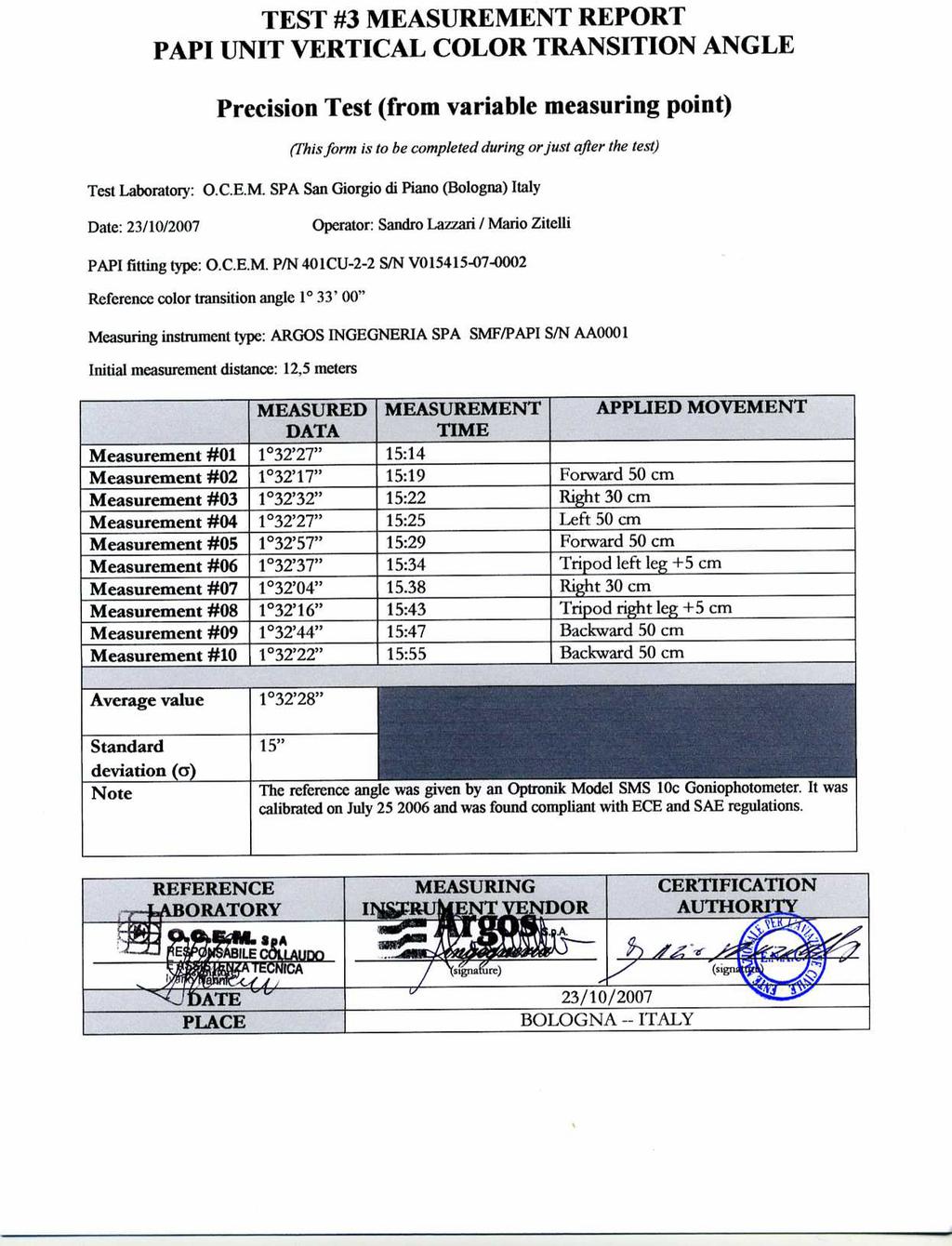
6 VAWG/5-DP/ ANNEX A Results of lab tests Test# 1 represents the accuracy test and refers to a set of 10 measurements to be evaluated respect to the angle imposed to the reference PAPI unit. Test#2 represents the precision test and refers to a set of 10 measurements carried out with the instrument in a stable position. Test#3 represents a repetition of precision test with the instrument measuring the same reference PAPI unit from different positions.

7 VAWG/5 DP/18
8 VAWG/5-DP/18-8-
Order No. G Date: September 8, 2010 REPORT NO CRT-001 TEST OF SMF/PAPI SYSTEM RENDERED TO
 REPORT 3933 US ROUTE 11 CORTLAND, NEW YORK 13045 Order No. G100147381 Date: September 8, 2010 INTRODUCTION REPORT NO. 100147381CRT-001 TEST OF SMF/PAPI SYSTEM RENDERED TO ARGOS INGEGNERIA SpA VIA TIBURTINA,
Positive Signal The most technologically advanced. double coated dichroic filters are used, which transmit
 The PAPI (Precision Approach Path Indicator) system is a simple and efficient, positive visual aid to the pilot on final approach. The PAPI system consists of a line of four units at 90 to the runway center
the issue of for Aviation
 2/3/12 INTERNATIONAL VOLCANIC ASH TASK FORCE (IVATF) SECOND MEETING Montréal, 11 to 15 July 2011 List of Recommendations The second meeting of the International Volcanic Ash Task Force (IVATF/2), held
Introduction to atmospheric visibility estimation
 BRISTOL INDUSTRIAL AND RESEARCH ASSOCIATES LIMITED PO Box, Harbour Road, Portishead, Bristol, BS0 7BL, UK Telephone : +44 (0)175 847787 Facsimile : +44(0)175 847303 E-mail: info@biral.com Home Page at
Inspection of. Aerodrome Lighting Federal Aviation 1. Administration
 Inspection of Aerodrome Lighting Presented to: ICAO/ FAA Aerodrome Certification Inspectors Workshop for the Caribbean Region By: Laurie Dragonas, FAA Lead Airport Certification/Safety Inspector Date:
New Zealand Aeronautical Charting the ArcMap Challenge. Presenter: Beryl Pimblott Explorer Graphics Ltd
 New Zealand Aeronautical Charting the ArcMap Challenge Presenter: Beryl Pimblott Explorer Graphics Ltd Abstract This presentation will be on the production of a national series of Visual Navigation charts
AWOS. Automated Weather Observing Systems COASTAL
 AWOS Automated Weather Observing Systems COASTAL Environmental Systems Monitor Monitor Your Your World World Coastal s Experience & Expertise Since 1981, Coastal Environmental Systems, Inc. (Coastal) has
AERODROMES PANEL (AP) SECOND MEETING OF THE AERODROMES PANEL WORKING GROUPS (APWGs/2)
 SECOND MEETING OF THE AERODROMES PANEL WORKING GROUPS (APWGs/2)") International Civil Aviation Organization APWGs/2-IP/04 26/11/13 INFORMATION PAPER AERODROMES PANEL (AP) SECOND MEETING OF THE AERODROMES PANEL WORKING GROUPS (APWGs/2) Agenda Item 2 b): Report of AOSWG
International Civil Aviation Organization APWGs/2-IP/04 26/11/13 INFORMATION PAPER AERODROMES PANEL (AP) SECOND MEETING OF THE AERODROMES PANEL WORKING GROUPS (APWGs/2) Agenda Item 2 b): Report of AOSWG
FAA AIRFIELD LIGHTING STANDARDS UPDATE
 FAA AIRFIELD LIGHTING STANDARDS UPDATE Present to: IES ALC GOVERNMENT LIGHTING COMMITTEE WASHINGTON, DC May 7, 2015 Tom Mai FAA Airport Engineering Division (AAS-100) Agenda FAA Airfield Lighting Equipment
Ground verification checks for PAPI.
 Ground verification checks for PAPI. Synopsis: The performance and calibration of the PAPI projectors, clinometer, and veracity of the relationship between the two can be verified on the ground. The method
Montréal, 7 to 18 July 2014
 INTERNATIONAL CIVIL AVIATION ORGANIZATION WORLD METEOROLOGICAL ORGANIZATION 6/5/14 Meteorology (MET) Divisional Meeting (2014) Commission for Aeronautical Meteorology Fifteenth Session Montréal, 7 to 18
Establishment of Space Weather Information Service
 Establishment of Space Weather Information Service For International Air Navigation Raul Romero Technical Officer MET ICAO Headquarters, Montreal NAM/CAR/SAM Seminar on Space Weather and ICAO Weather Information
SOFTWARE. Control of the AMS SYSTEM CONTROL AND MONITORING OF AIRFIELD GROUND LIGHTING EQUIPMENT
 Control of the AMS SYSTEM SOFTWARE CONTROL AND MONITORING OF AIRFIELD GROUND LIGHTING EQUIPMENT Description of function airfield ground lighting equipment are shown on the screen representing the airport
Three-Dimensional Aerial Zoning around a Lebanese Airport
 Three-Dimensional Aerial Zoning around a Lebanese Airport Abstract by Oussama C. Jadayel and Rita Y. Ibrahim GIS Center, Faculty of Engineering, University of Balamand, P.O. Box: 100, Tripoli, LEBANON
QNH: With this setting set on your altimeter you will be reading altitude above mean sea level based on the local station pressure.
 ALTIMETRY How many different altimeter settings confront you when operating internationally? Not only that, how many different ways are there to report an altimeter setting? If not operating internationally
NATIONAL TRANSPORTATION SAFETY BOARD WASHINGTON, D.C. SAFETY RECOMMENDATION LETTER TO THE FAA dated NOVEMBER 21, 1994, AND RESPONSES.
 DOCKET NO.: SA-517 EXHIBIT NO. 3-R NATIONAL TRANSPORTATION SAFETY BOARD WASHINGTON, D.C. SAFETY RECOMMENDATION LETTER TO THE FAA dated NOVEMBER 21, 1994, AND RESPONSES (22 pages) / /7 8!?>3 @. National
The current status, functions, challenges and needs of South Sudan Meteorological Department (SSMD)
") The current status, functions, challenges and needs of South Sudan Meteorological Department (SSMD) Presented: by Mojwok Ogawi Modo, South Sudan Meteorological Department. Background The present SSMD was
The current status, functions, challenges and needs of South Sudan Meteorological Department (SSMD) Presented: by Mojwok Ogawi Modo, South Sudan Meteorological Department. Background The present SSMD was
AERODROME METEOROLOGICAL OBSERVATION AND FORECAST STUDY GROUP (AMOFSG)
") AMOFSG/10-IP/4 21/5/13 AERODROME METEOROLOGICAL OBSERVATION AND FORECAST STUDY GROUP (AMOFSG) TENTH MEETING Montréal, 17 to 19 June 2013 Agenda Item 5: Aerodrome observations AUTOMATED CLOUD INFORMATION
AMOFSG/10-IP/4 21/5/13 AERODROME METEOROLOGICAL OBSERVATION AND FORECAST STUDY GROUP (AMOFSG) TENTH MEETING Montréal, 17 to 19 June 2013 Agenda Item 5: Aerodrome observations AUTOMATED CLOUD INFORMATION
Airport Meteorology Analysis
 Airport Meteorology Analysis Alex Alshtein Kurt Etterer October 2014 Presented at ICAO Business Class 2014 ICAO, Montreal, Canada Approved for Public Release: 14-3466. Distribution Unlimited. October 2014
CAP 437 Offshore Meteorological Observer Training
 CAP 437 Offshore Meteorological Observer Training Training for Meteorological Observers in support of Offshore Helicopter Operations CAP 437 Offshore Meteorological Observer Training Page 1 Meteorological
METEOROLOGY PANEL (METP) WORKING GROUP- METEOROLOGICAL OPERATION GROUP (MOG) FIRST MEETING
 WORKING GROUP- METEOROLOGICAL OPERATION GROUP (MOG) FIRST MEETING") 8 28/7/15 METEOROLOGY PANEL (METP) WORKING GROUP- METEOROLOGICAL OPERATION GROUP (MOG) FIRST MEETING Gatwick, United Kingdom, 08 to 11 September 2015 Agenda Item 3: Matters relating to SADIS 3.3: Operations
8 28/7/15 METEOROLOGY PANEL (METP) WORKING GROUP- METEOROLOGICAL OPERATION GROUP (MOG) FIRST MEETING Gatwick, United Kingdom, 08 to 11 September 2015 Agenda Item 3: Matters relating to SADIS 3.3: Operations
Edmonton International Airport YXD City Centre Airport
 Table of Contents Edmonton International Airport YXD City Centre Airport Airside Operations Winter Operations Program 2012/13 September 10, 2012 Table of Contents AIRSIDE WINTER OPERATIONS PROGRAM (AER-002P)
AERODROME METEOROLOGICAL OBSERVATION AND FORECAST STUDY GROUP (AMOFSG)
") AMOFSG/9-SN No. 15 21/6/11 AERODROME METEOROLOGICAL OBSERVATION AND FORECAST STUDY GROUP (AMOFSG) NINTH MEETING Montréal, 26 to 30 September 2011 Agenda Item 5: Observing and forecasting at the aerodrome
AMOFSG/9-SN No. 15 21/6/11 AERODROME METEOROLOGICAL OBSERVATION AND FORECAST STUDY GROUP (AMOFSG) NINTH MEETING Montréal, 26 to 30 September 2011 Agenda Item 5: Observing and forecasting at the aerodrome
Pilot briefing ENTC - Tromsø airport, Langnes
 Pilot briefing ENTC - Tromsø airport, Langnes NOTE: The content in this briefing will not be updated as frequently as AIP Norway. Make sure you always check relevant information in the latest edition of
IMS4 ARWIS. Airport Runway Weather Information System. Real-time data, forecasts and early warnings
 Airport Runway Weather Information System Real-time data, forecasts and early warnings Airport Runway Weather Information System FEATURES: Detection and prediction of runway conditions Alarms on hazardous
ADL110B ADL120 ADL130 ADL140 How to use radar and strike images. Version
 ADL110B ADL120 ADL130 ADL140 How to use radar and strike images Version 1.00 22.08.2016 How to use radar and strike images 1 / 12 Revision 1.00-22.08.2016 WARNING: Like any information of the ADL in flight
Obstruction Lighting Guide
 Obstruction Lighting Guide Obstruction Lighting Devices as Tough as Your Environment For more than a century, companies have come to rely on Cooper Crouse-Hinds for value they can trust to grow their business.
CMO Terminal Aerodrome Forecast (TAF) Verification Programme (CMOTafV)
 Verification Programme (CMOTafV)") CMO Terminal Aerodrome Forecast (TAF) Verification Programme (CMOTafV) Kathy-Ann Caesar Meteorologist Caribbean Meteorological Council - 47 St. Vincent, 2007 CMOTafV TAF Verification Programme Project:
CMO Terminal Aerodrome Forecast (TAF) Verification Programme (CMOTafV) Kathy-Ann Caesar Meteorologist Caribbean Meteorological Council - 47 St. Vincent, 2007 CMOTafV TAF Verification Programme Project:
Field study of the latest transmissometers at Hong Kong International Airport
 Field study of the latest transmissometers at Hong Kong International Airport P. W. Chan Hong Kong Observatory 134A Nathan Road, Kowloon, Hong Kong, China Tel:+852 2926 8435, Fax: +852 2311 9448, Email:
AERODROME METEOROLOGICAL OBSERVATION AND FORECAST STUDY GROUP (AMOFSG)
") AMOFSG/10-SN No. 5 19/4/13 AERODROME METEOROLOGICAL OBSERVATION AND FORECAST STUDY GROUP (AMOFSG) TENTH MEETING Montréal, 17 to 19 June 2013 Agenda Item 5: Aerodrome observations REPORTING OF RUNWAY VISUAL
AMOFSG/10-SN No. 5 19/4/13 AERODROME METEOROLOGICAL OBSERVATION AND FORECAST STUDY GROUP (AMOFSG) TENTH MEETING Montréal, 17 to 19 June 2013 Agenda Item 5: Aerodrome observations REPORTING OF RUNWAY VISUAL
WORLD AREA FORECAST SYSTEM OPERATIONS GROUP (WAFSOPSG)
") International Civil Aviation Organization WAFSOPSG/7-WP/10 5/7/12 WORKING PAPER WORLD AREA FORECAST SYSTEM OPERATIONS GROUP (WAFSOPSG) SEVENTH MEETING Lima, Peru, 17 to 21 September 2012 Agenda Item 6:
International Civil Aviation Organization WAFSOPSG/7-WP/10 5/7/12 WORKING PAPER WORLD AREA FORECAST SYSTEM OPERATIONS GROUP (WAFSOPSG) SEVENTH MEETING Lima, Peru, 17 to 21 September 2012 Agenda Item 6:
International Civil Aviation Organization
 CNS/MET SG/14 IP/19 International Civil Aviation Organization FOURTEENTH MEETING OF THE COMMUNICATIONS/NAVIGATION/SURVEILL ANCE AND METEOROLOGY SUB-GROUP OF APANPIRG (CNS/MET SG/14) Jakarta, Indonesia,
HEIGHT ALTITUDE FLIGHT LEVEL
 HEIGHT ALTITUDE FLIGHT LEVEL 1. Definition There are several ways to indicate the vertical position of aircraft and/or obstacles; each has another meaning and is used in a particular situation: 2. Units
Economic and Social Council
 United Nations Economic and Social Council ECE/TRANS/WP.29/GRE/2017/20 Distr.: General 7 August 2017 Original: English Economic Commission for Europe Inland Transport Committee World Forum for Harmonization
AVIATION INVESTIGATION REPORT A04A0057 WING SCRAPE DURING A REJECTED LANDING
 AVIATION INVESTIGATION REPORT A04A0057 WING SCRAPE DURING A REJECTED LANDING CARGOJET AIRWAYS LIMITED BOEING 727-225 C-GCJB GREATER MONCTON INTERNATIONAL AIRPORT MONCTON, NEW BRUNSWICK 28 MAY 2004 The
Preventing Runway Excursions. Landing on wet / Contaminated Runways
 Preventing Runway Excursions Landing on wet / Contaminated Runways Overview Introduction Definition Runway Condition Runway Condition Reporting Pilot Operational Aspects Landing Performance Airport Operational
Preventing Runway Excursions. Landing on wet / Contaminated Runways
 Preventing Runway Excursions Landing on wet / Contaminated Runways Overview Introduction Definition Runway Condition Runway Condition Reporting Pilot Operational Aspects Landing Performance Airport Operational
A Path to Shed Light on the Windshear. Enhancing the windshear alerting systems in airports by integrating a LiDAR-based system.
 DTN WHITE PAPER A Path to Shed Light on the Windshear Enhancing the windshear alerting systems in airports by integrating a LiDAR-based system August 2017 www.dtn.com / 1.800.509.8927 2017 DTN, Inc Summary
MetConsole AWOS. (Automated Weather Observation System) Make the most of your energy SM
 Make the most of your energy SM") MetConsole AWOS (Automated Weather Observation System) Meets your aviation weather needs with inherent flexibility, proven reliability Make the most of your energy SM Automated Weather Observation System
MetConsole AWOS (Automated Weather Observation System) Meets your aviation weather needs with inherent flexibility, proven reliability Make the most of your energy SM Automated Weather Observation System
and SUMMARY preliminary parameters. 1.1 MET/14-IP/ /15 In line 1.2 WORLD INTERNATIONAL CIVIL AVIATION ORGANIZATION 2/6/14 English only
 INTERNATIONAL CIVIL AVIATION ORGANIZATION Meteorology (MET) Divisional Meeting (2014) WORLD METEOROLOGICAL ORGANIZATION Commission for Aeronautical Meteorology Fifteenth Session MET/14-IP/ /15 2/6/14 English
Opportunities and Risks National Responses Austria Aeronautical MET Services -Part of an ATC Provider
 Opportunities and Risks National Responses Austria Aeronautical MET Services -Part of an ATC Provider AUSTRO CONTROL is the former Federal Office of Civil Aviation. is a company with limited liability.
A compilation of key maintenance and performance articles taken from the former Lycoming Flyer Newsletter. Lycoming Flyer Key Reprints
 A compilation of key maintenance and performance articles taken from the former Lycoming Flyer Newsletter Lycoming Flyer Key Reprints D e a r Lycoming Flyer C u s t o m e r, O u r K e y R e p r i n t
White Paper. Perform Conductivity Measurements In Compliance with USP <645>
 Perform Conductivity Measurements In Compliance with USP Water is the most widely used substance, raw material, or ingredient in the production, processing and formulation of compendial articles.
Edmonton International Airport
 Edmonton International Airport ZVL Airside Operations Winter Operations Program 2012/13 September 10, 2012 ZVL_pla.dgn Default 12/17/07 5:10:28 PM AIRSIDE WINTER OPERATIONS PROGRAM (AER-002P) DISTRIBUTION/REVISION
3-D METROLOGY APPLIED TO SUPERCONDUCTING DIPOLE MAGNETS FOR LHC
 3-D METROLOGY APPLIED TO SUPERCONDUCTING DIPOLE MAGNETS FOR LHC M. DUPONT*, D. MISSIAEN, L. PEGUIRON CERN, European Laboratory for Particle Physics, Geneva, Switzerland 1. INTRODUCTION The construction
MetConsole LLWAS (Low Level Wind Shear Alert System)
") MetConsole LLWAS (Low Level Wind Shear Alert System) Enhancing aircraft safety under wind shear conditions Make the most of your energy SM MetConsole Low Level Wind Shear Alert System The Schneider Electric
MetConsole LLWAS (Low Level Wind Shear Alert System) Enhancing aircraft safety under wind shear conditions Make the most of your energy SM MetConsole Low Level Wind Shear Alert System The Schneider Electric
The Importance of Measuring Water Film Depth
 The Importance of Measuring Water Film Depth White Paper www.dtn.com / +31 345 544 080 Copyright 2018 DTN As water accumulates on a runway due to intense rainfall or other factors, aircraft are at risk
Deutscher Wetterdienst
 WakeNet3-Greenwake Workshop Wake Vortex & Wind Monitoring Sensors in all weather conditions DWD s new Remote Wind Sensing Equipment for an Integrated Terminal Weather System (ITWS) Frank Lehrnickel Project
Volcanic Ash Guidance Material Docs. 9766, 9691 and 9974
 International Civil Aviation Organization Raul Romero ICAO IAVWOPSG Secretary 2 Section 1 Scientific background Chapter 1. Volcanic eruptions 1.1 Classification 1.2 Mechanism of volcanic eruptions 1.3
ANALYSIS OF AIRCRAFT LATERAL PATH TRACKING ACCURACY AND ITS IMPLICATIONS FOR SEPARATION STANDARDS
 ANALYSIS OF AIRCRAFT LATERAL PATH TRACKING ACCURACY AND ITS IMPLICATIONS FOR SEPARATION STANDARDS Michael Cramer, The MITRE Corporation, McLean, VA Laura Rodriguez, The MITRE Corporation, McLean, VA Abstract
A map is a small-scale flat-surface representation of some portion of the earth s surface.
 MAPS AND CHARTS A map is a small-scale flat-surface representation of some portion of the earth s surface. A representation that is designed for plotting navigational information is called a chart. Often
Learning. Goals. Page 1 of 6. Document : V1.1
 Learning Goals Lights configurations Airplane Page 1 of 6 Page 2 of 6 The external lights on aircraft fall into two general categories. The first is navigation lights or beacons thatt are always illuminated
^_ Key Observation Point Viewshed Model. Grazing Yak Solar Project. Key Observation Point Location Map KOP #6 KOP #3 KOP #1 KOP #2 KOP #4 KOP #5
 Liberty Rd Paint Mine Rd Mc Queen Rd Paint Mine Rd E q Funk Rd ^_ KOP #6 Currier Rd Washington Rd ^_ KOP #1 ^_ KOP #2 ^_ KOP #3 Hanisch Rd ^_ KOP #4 Judge Orr Rd ^_ KOP #5 0 1,000 2,000 Feet Solar Array
Advisory Circular. U.S. Department of Transportation Federal Aviation Administration
 U.S. Department of Transportation Federal Aviation Administration Subject: Use of Liquid Water Equivalent System to Determine Holdover Times or Check Times for Anti-Icing Fluids Advisory Circular Date:
Vaisala AviMet Automated Weather Observing System
 Vaisala AviMet Automated Weather Observing System Solutions to meet your challenges Our mission: to help you operate succesfully Safe, economical, reliable and flexible operation of your airport is ensured
AN INSTRUMENT FOR THE MEASUREMENT OF ROAD SURFACE REFLECTION PROPERTIES
 AN INSTRUMENT FOR THE MEASUREMENT OF ROAD SURFACE REFLECTION PROPERTIES Corell, D. D 1, Sørensen, K. 2 1 Technical University of Denmark, DTU Fotonik, 4000 Roskilde, DENMARK, 2 Johnsen Consult, 2100 København
Guidance on Aeronautical Meteorological Observer Competency Standards
 Guidance on Aeronautical Meteorological Observer Competency Standards The following guidance is supplementary to the AMP competency Standards endorsed by Cg-16 in Geneva in May 2011. Format of the Descriptions
AN AUTOMATED GONIOPHOTOMETER FOR LUMINAIRE CHARACTERIZATION
 Copyright 2002 IFAC 15th Triennial World Congress, Barcelona, Spain AN AUTOMATED GONIOPHOTOMETER FOR LUMINAIRE CHARACTERIZATION V. F. Muñoz, J. Gómez-de-Gabriel, J. Fernández-Lozano, R. Molina-Mesa, J.
Edmonton International Airport
 Edmonton International Airport ZVL Airside Operations Winter Operations Program 2017/18 September, 2017 AIRSIDE WINTER OPERATIONS PROGRAM (AER-002P) DISTRIBUTION/REVISION LIST Distribution Edmonton Airports
U.S. Standard for Revolving Pedestrian Doors Seriously Flawed
 U.S. Standard for Revolving Pedestrian Doors Seriously Flawed Warren F. Davis, Ph.D. Davis Associates, Inc. 43 Holden Road Newton, MA 02465-1909 June 21, 2009 Introduction The current version of the American
Auto collimator. Introduction. Objectives: Apparatus: Theory:
 Auto collimator Introduction An autocollimator is an optical instrument that is used to measure small angles with very high sensitivity. As such, the autocollimator has a wide variety of applications including
NINTH MEETING DISPLAY IN ATS UNITS. (Presented SUMMARY
 AMOFSG/9-SN No. 26 12/8/11 AERODROME METEOROLOGICAL OBSERVATION AND FORECAST STUDY GROUP (AMOFSG) NINTH MEETING Montréal, 26 to 30 September 2011 Agenda Item 6: MET informationn to support ATM UPDATING
Heliport solutions A safer approach. Heliport solutions for increased safety
 eliport solutions A safer approach eliport solutions for increased safety ow do you secure a safe touch-down and lift-off? A view from an urban rooftop during bad weather conditions A safer approach Some
Wrap-Up Meeting of the pilot project on SIGMET Coordination in South East Asia (MetMalaysia, MSS & BMKG) Singapore
 Singapore") Wrap-Up Meeting of the pilot project on SIGMET Coordination in South East Asia (MetMalaysia, MSS & BMKG) Singapore 27-29 March 2017 Agenda Item 4 (NMHS experiences and recommendations) Hamray Bin Muhammad
Wrap-Up Meeting of the pilot project on SIGMET Coordination in South East Asia (MetMalaysia, MSS & BMKG) Singapore 27-29 March 2017 Agenda Item 4 (NMHS experiences and recommendations) Hamray Bin Muhammad
Development of System for Supporting Lock Position Adjustment Work for Electric Point Machine
 PAPER Development of System for Supporting Lock Position Adjustment Work for Electric Point Machine Nagateru IWASAWA Satoko RYUO Kunihiro KAWASAKI Akio HADA Telecommunications and Networking Laboratory,
CHAPTER 26 PLANNING AND ZONING ARTICLE XIV. AIRPORT OVERLAY ZONING
 CHAPTER 26 PLANNING AND ZONING ARTICLE XIV. AIRPORT OVERLAY ZONING Section 26-XIV-1. Purpose and Findings Section 26-XIV-2. Definitions Section 26-XIV-3. Maps & Boundaries Section 26-XIV-4. Airport Height
Demo Scenario Jumpstart
 Demo Scenario Jumpstart Document history Version Date Status Author Changes 0.0 27/03/2015 Draft Tim Initial version Contents Introduction... 2 Starting Jumpstart... 2 The Jumpstart Window... 2 The scenario...
Module Optical Analyzer: Identification Of Defects On The Production Line
 Module Optical Analyzer: Identification Of Defects On The Production Line Rebeca Herrero, Stephen Askins, Ignacio Antón, Gabriel Sala, Kenji Araki Hirokazu Nagai Abstract. The usefulness of the module
Edmonton International Airport
 Edmonton International Airport ZVL Airside Operations inter Operations Program 2014/15 September 01, 2014 gate gate I.L.S. LOCALIZER26 08 HOLD BAY 08 PAPI HOLD BAY 16 OUTFIELD RY08/26 I.L.S. GLIDEPATH
GEN 3.5 METEOROLOGICAL SERVICES
 AIP GEN 3.5-1 GEN 3.5 METEOROLOGICAL SERVICES 1. RESPONSIBLE SERVICE The meteorological services for civil aviation at Jordan are provided by the Jordanian Meteorological Department. Postal Address: Director
CHARA Meeting 2017 Pasadena, California
 MORE AUTOMATION Laszlo Sturmann M7 ACTUATORS LAB. LASER ALIGNMENT TELESCOPE OPTICAL ALIGNMENT NEW ACTUATORS REMOTELY ACTUATED M7 MOUNT MOTIVATION THE PRECISION OF THE COUDE ALIGNMENT WAS NOT SUFFICIENT
CHAPTER 3 HELIPORT AND HELICOPTER STAGEFIELD LIGHTING SYSTEMS
 CHAPTER 3 HELIPORT AND HELICOPTER STAGEFIELD LIGHTING SYSTEMS TM 5-811-5 3-1. General design and layout criteria lights spaced approximately 17 feet on centers. The outera. Heliport runway. Figures 2-1,
Meteorological CLEAR BUT PRESENT DANGER
 THE INTERNATIONAL REVIEW OF WEATHER, CLIMATE, AND HYDROLOGY TECHNOLOGIES AND SERVICES Meteorological AUGUST 2012 T E C H N O L O G Y I N T E R N A T I O N A L CLEAR BUT PRESENT DANGER The latest Earth
UNIVERSITY OF HAWAI I SYSTEM TESTIMONY
 UNIVERSITY OF HAWAI I SYSTEM TESTIMONY SCR 46 / SR 27 REQUESTING THE DEPARTMENT OF TRANSPORTATION TO COMPLY WITH COUNTY ORDINANCES AND STANDARDS RELATING TO OUTSIDE LIGHTING AT AIRPORTS AND HARBORS, AND
SEPARATION AND AIRSPACE SAFETY PANEL (SASP) MEETING OF THE WORKING GROUP OF THE WHOLE
 MEETING OF THE WORKING GROUP OF THE WHOLE") International Civil Aviation Organization WORKING PAPER SASP-WG/WHL/21-WP/29 26/10/2012 SEPARATION AND AIRSPACE SAFETY PANEL (SASP) MEETING OF THE WORKING GROUP OF THE WHOLE TWENTY FIRST MEETING Seattle,
International Civil Aviation Organization WORKING PAPER SASP-WG/WHL/21-WP/29 26/10/2012 SEPARATION AND AIRSPACE SAFETY PANEL (SASP) MEETING OF THE WORKING GROUP OF THE WHOLE TWENTY FIRST MEETING Seattle,
Testimony Related to
 Testimony Related to SENATE CONCURRENT RESOLUTION 46 - REQUESTING THE DEPARTMENT OF TRANSPORTATION TO COMPLY WITH COUNTY ORDINANCES AND STANDARDS RELATING TO OUTSIDE LIGHTING AT AIRPORTS AND HARBORS, AND
SUMMARY. information from
 INTERNATIONAL CIVIL AVIATION ORGANIZATION WORLD METEOROLOGICAL ORGANIZATION MET/14-IP/ /16 2/6/14 English only Meteorology (MET) Divisional Meeting (2014) Commission for Aeronautical Meteorology Fifteenth
Montréal, 7 to 18 July 2014
 INTERNATIONAL CIVIL AVIATION ORGANIZATION WORLD METEOROLOGICAL ORGANIZATION MET/14-WP/34 28/5/14 Meteorology (MET) Divisional Meeting (2014) Commission for Aeronautical Meteorology Fifteenth Session Montréal,
Airport and Runway Markings and Lighting
 Airport and Runway Markings and Lighting Runway Markings Reference: AIM 2-3-3 Runway designation markings are runway numbers and letters that are determined from the approach direction. The runway number
IMS4 AWOS. Automated Weather Observation System. Integrates all airport weather data
 Integrates all airport weather data IMS4 AWOS FEATURES: Integrates all airport weather data Scalable up to ICAO category CAT III Conforms to the ICAO and WMO regulations and recommendations AWOS data on
THE LASER TRACKER : A MAJOR TOOL FOR THE METROLOGY OF THE LHC
 IWAA2004, CERN, Geneva, 4-7 October 2004 THE LASER TRACKER : A MAJOR TOOL FOR THE METROLOGY OF THE LHC M. Dupont, D. Missiaen, P. Winkes, CERN*, 1211 Geneva 23, Switzerland 1. INTRODUCTION The Large Hadron
TERMS OF REFERENCE Special Committee (SC) 230 Airborne Weather Detection Systems Revision 5
 230 Airborne Weather Detection Systems Revision 5") TERMS OF REFERENCE Special Committee (SC) 230 Airborne Weather Detection Systems Revision 5 REQUESTORS: Organization FAA Associate Administrator for Aviation Safety Person Ms. Peggy Gilligan SC LEADERSHIP:
TERMS OF REFERENCE Special Committee (SC) 230 Airborne Weather Detection Systems Revision 5 REQUESTORS: Organization FAA Associate Administrator for Aviation Safety Person Ms. Peggy Gilligan SC LEADERSHIP:
Meteorological Service
 Meteorological Service The Meteorological Service in Oman was established in 1973. Oman joined ICAO in 1973 Oman joined WMO in 1975. Meteorological Service is under the framework of the Directorate General
Visibility and present weather sensors. you can trust... visibly better
 Visibility and present weather sensors you can trust... Biral HSS sensors visibly better CONTENTS HSS Application Examples PAGE 2 (this page) APPLICATION EXAMPLES 1 (Highway and Research) TRACK RECORD
USE OF GROUND BASED WEATHER RADAR DATA IN AIR TRAFFIC MANAGEMENT PROCEDURES
 USE OF GROUND BASED WEATHER RADAR DATA IN AIR TRAFFIC MANAGEMENT PROCEDURES EUROCONTROL Workshop on MET support to ATM Brussels, 27 th -28 th May 2009 Dr. Marco Tadini Head, Planning and Development Meteorology
GCAA ADVISORY CIRCULAR
 GUYANA CIVIL AVIATION AUTHORITY 73 High Street Kingston Georgetown GUYANA TEL. NOs: (592) 225 6822, 225 0778, 227 8111 FAX: (592) 225 6800 E-mail: director-general@gcaa-gy.org GCAA ADVISORY CIRCULAR AERODROME
THERMOFOCUS, a technological innovation
 06600 THERMOFOCUS, a technological innovation Thermofocus Animal is the evolution of Thermofocus, the world's first non-contact thermometer intended for human use. With Thermofocus, Tecnimed introduced
HONOURTEK Delux Array Series HRA0303 Preliminary
 HONOURTEK Delux Array Series HRA0303 Preliminary Product Data Sheet HRA0303 Product Introduction The Delux Series LED Array products deliver high quality light with Delux lighting-class reliability. This
Flying Around Volcanic Clouds: A Pilots Account
 Klaus Sievers German Airline Pilots Association (Vereinigung Cockpit e.v.) Unterschweinstiege 10 60549 Frankfurt Germany Klaus.Sievers@VCockpit.de ABSTRACT Eyjafjallajökull - Bardarbunga - Puyehue: words
CHAPTER CONTENTS REFERENCES AND FURTHER READING Page
 CHAPTER CONTENTS CHAPTER 2. MEASUREMENTS AND OBSERVATIONS AT AERONAUTICAL METEOROLOGICAL STATIONS... 553 2.1 General... 553 2.1.1 Definitions... 553 2.1.2 Units... 553 2.1.3 Requirements... 553 2.1.4 Methods...
Automated in-situ Turbulence reports from Airbus aircraft. Axel PIROTH
 Automated in-situ Turbulence reports from Airbus aircraft Axel PIROTH Context & Background Atmospheric Turbulence is leading to situations somewhat uncomfortable... Page 2 Cost of Turbulence for Air Carriers
J11.3 Aviation service enhancements across the National Weather Service Central Region
 J11.3 Aviation service enhancements across the National Weather Service Central Region Brian P. Walawender * National Weather Service Central Region HQ, Kansas City, MO Jennifer A. Zeltwanger National
Chapter 1 Overview of Maps
 Chapter 1 Overview of Maps In this chapter you will learn about: Key points when working with maps General types of maps Incident specific maps Map legend and symbols Map sources A map is a navigational
Lightning Safety in a Flash / VAISALA AIRPORT LIGHTNING INFORMATION SYSTEM (ALIS)
") Lightning Safety in a Flash / VAISALA AIRPORT LIGHTNING INFORMATION SYSTEM (ALIS) Global Threat to Airports Proven. Global. The Vaisala Airport Lightning Information System (ALIS) opens a new era of universal
Lightning Safety in a Flash / VAISALA AIRPORT LIGHTNING INFORMATION SYSTEM (ALIS) Global Threat to Airports Proven. Global. The Vaisala Airport Lightning Information System (ALIS) opens a new era of universal
Blunt Impact Damage Formation on Composite Aircraft Structures
 Blunt Impact Damage Formation on Composite Aircraft Structures FAA Supported Research Project Hyonny Kim, Associate Professor University of California, San Diego Hyonny Kim, UCSD 1 incidental contact /
HONOURTEK Delux Array Series HRA0407 Preliminary
 Copyright 2018 HONOURTEK,INC.ALL RIGH TS RESERVED HONOURTEK Delux Array Series HRA0407 Preliminary Product Data Sheet HRA0407 Product Introduction The Delux Series LED Array products deliver high quality
Maritime Weather Information: Automatic Reporting, A New Paradigm
 Maritime Weather Information: Automatic Reporting, A New Paradigm Joe Sienkiewicz, NOAA/NWS Ocean Prediction Center Responsibilities under SOLAS Met Services Contracting governments Observations Limited
Implementation Guidance of Aeronautical Meteorological Observer Competency Standards
 Implementation Guidance of Aeronautical Meteorological Observer Competency Standards The following guidance is supplementary to the AMP competency Standards endorsed by Cg-16 in Geneva in May 2011. Please
MEASUREMENTS AND OBSERVATIONS AT AERONAUTICAL METEOROLOGICAL STATIONS
 II.2 1 CHAPTER 2 MEASUREMENTS AND OBSERVATIONS AT AERONAUTICAL METEOROLOGICAL STATIONS 2.1 General 2.1.1 Definitions This chapter deals with the requirements for observations at aeronautical meteorological
GENERAL REQUIREMENTS FOR SHOREBASED AIRFIELD MARKING AND LIGHTING
 NAVAIR 51-50AAA-2 1 MAY 2003 CHANGE 3 1 NOVEMBER 2017 TITLE TECHNICAL MANUAL GENERAL REQUIREMENTS FOR SHOREBASED AIRFIELD MARKING AND LIGHTING DISTRIBUTION STATEMENT A. Approved for public release; distribution