IGS Reprocessing. and First Quality Assessment
|
|
|
- Clifton Payne
- 5 years ago
- Views:
Transcription

1 IGS Reprocessing Summary of Orbit/Clock Combination and First Quality Assessment Gerd Gendt, GeoForschungsZentrum Potsdam Jake Griffiths, NOAA/National Geodetic Survey Thomas Nischan, GeoForschungsZentrum Potsdam Jim Ray, NOAA/National Geodetic Survey General information about the Repro1 activity Combination results and consistency of products Assessment of the product accuracy PPP with combined products Orbit overlaps IGS Workshop - 30 June Newcastle 1
2 Why Reprocessing To obtain a full history of IGS Final products using the latest models Absolute antenna model (igs05.atx) P1-C1 satellite code biases were updated IERS 2003 Conventions generally implemented Updated model for station displacements due to ocean tidal loading (FES2004; whole-earth center-of-mass corrections) Updated models for troposphere propagation delays No 2nd order ionospheric effects (for details, see Remove inconsistencies over time due to frame changes Use of IGS05 frame first attempt to obtain a full history of IGS products in a fully consistent framework IGS contribution with homogenous products to ITRF2008 2
3 History 2007: Year-2000 (Jan-Apr) test campaign Feb 2008: begin of full reprocessing Jun 2008: IGS workshop, evaluation of year 2000-test and 2007 products Schedule: Operational IGS Shift of schedule: Ready in Nov 2009 Ready in Jan 2009 Nov 2009: Test combination were performed to check the quality and to identify problems; Some corrected resubmissions followed Mar/Apr 2010 combination finished (not yet clock alignment to IGS time frame; affects no other products) 3
4 AC Products /Combination Centers Products: Daily orbits - 15min sampling Daily satellite and station clocks - 5 min sampling (no 30s for repro1) Daily ERP (x&y and rates; LOD) Weekly SINEX files with station coordinates, ERP Weekly satellite antenna offsets (4 ACs: CO1, EM1, GF1, MIT) Aligned to the IGS05 reference frame, absolute antenna model Combination Centers NRCan: SINEX combination GFZ: Orbit & clock combination NRL: IGS Time Scale based on combined clocks 4
5 Contributing ACs AC Code Software From 19.. (yrs) Clk CODE/AIUB Switzerland CO1 Bernese (14) EMR/NRCan Canada EM1 GIPSY 95 (13) clk ESA/ESOC Germany ES1 NAPEOS 95 (13) clk GFZ Germany GF1 GT1 EPOS 94 (14) 98 (10) JPL USA JP1 GIPSY 96 (12) clk MIT USA MI1 GAMIT 98 (10) clk NGS/NOAA USA NG1 PAGES 95 (13) SIO USA SI1 GAMIT 94 (14) PDR (Pdm/Dresden) Germany PD1 Bernese (14) ULR (La Rochelle) France UL1 GAMIT 96 (12) 10 Analysis Centers (2 from outside the IGS Final ACs) 5 different Software Packages Only 5 clock solutions (compared to operational product CO1 is missing) clk 5
6 Comparison of AC Parameters & Models (selection) AC Elev- Cutoff Elev-dep Wei Arc len. Velo Brks Earth Albedo Ocean tides CODE 3 yes 3d every 12h - CSR3.0 EMR 10-1d - - CSR ESA 10 yes 1d none; 1/rev yes&ir IERS2003 GFZ 7 yes 3d every 12h - CSR3.0 JPL d - yes FES2004 MIT 10 yes 1d none; 1/rev - - NGS 10 yes 1d every 12h - - PDR 3 yes 3d every 12h - CSR3.0 SIO 10 yes 1d none; 1/rev - none ULR 10?? 1d - - FES2004 6
7 Network AC #sta #ref EM PD JP CO ES GF GT UL NG SI MI Number of reference frame stations is critical before


8 Orbit comparisons 8
9 Combined SP3 Error code Sigma of the combined SP3 (top) Number of satellites with no sigma value (sigma=0; only 1 AC) (middle) Number of contributing ACs (most excl. are caused by high transf.) 9


10 Orbit Frame Differences: Translations Good internal consistency among ACs NG1 and UL1 have issues with Ty and Tz Seasonal effects in Tz, especially in operational IGS Finals and UL1 10


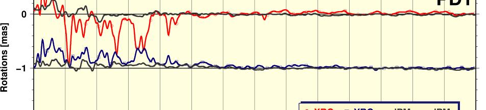
11 Orbit Frame Differences: Rotations Good internal consistency among ACs NG1, SI1 and UL1 have issues with Rx and Ry RF changes in operational IGS Finals over history 11


12 Orbit rotations & ERP differences There are some issues in aligning orbits, ERP and SINEX products 12
13 Clock Combination Number of ACs increased from 1 to 5 submissions (1994 only GF1!) Actual used contributions are sometimes smaller (blue) even after 1998 it goes down to 3 (or 2) After May 2000 more stable contributions 13
14 PPP Analysis using IG1 PPP with IG1 SP3 and clocks; each year 4 weeks analyzed Network of about 80 stations (goes down to ~25 in 1994) Helmert transformations to combined SNX for given week. Repeatability within a week (like PPP in operational IGS Final combination) 14
15 PPP Station RMS Weekly mean rms fit (over all stations) between the PPP computed station coordinates and the weekly SINEX in N E U (plus number of sta & sat) es o. of satellite No 15
16 PPP Frame transformations Rotation, translation, scale from that Helmert transformations No o. of satellite es 16
17 Orbit discontinuities Fit orbits for each day with BERNE (6+9) orbit model fit orbit SP3 positions as pseudo-observations for Days A & B parameterize daily fit with 3 positions, 3 velocities, plus 3 solar radiation pressure terms in each of 3 directions for each SV Propagate daily fits to 23:52: epoch on Day A Compare SP3 positions at 23:52:30 on Day A 1D magnitude of midpoint discontinuity ( P) is: P X igs X calc Y igs Y calc Z 3 The observed orbits spectra have been calibrated for the error spectrum of the fit procedure by fits at 23:45:00 [Griffiths & Ray, 2009] igs Z calc 17
18 Spectra for IG1 Orbit Jumps Along track Stacked over all SVs & lightly smoothed Odd draconic harmonics White noise floor ~5cm Fortnightly signal ~2cm Background errors follow ~flicker noise on seasonal time scales Improvement of white noise floor form 1996 to 2007: factor 3 Unexplained peaks at fortnightly frequencies and odd draconic harmonics 18


19 Spectra for IG1 Orbit Jumps Cross track Odd draconic harmonics White noise floor ~7cm Fortnightly signal ~1.5cm 19
20 Spectra for AC Orbit Jumps Along track Interval Mar 2005 Dec 2007 IG1 (2 cm) JP1 30h arc (1.7cm) PD1 3d arc CO1 3d arc (0.5cm) 20
21 Summary IG1 Products available at CDDIS (named repro1) Products are aligned to IGS05!!! (orbits and clocks) Based on orbit jumps, precision/accuracy of IG1 orbits ranges from ~7/sqrt(2) cm in to ~2/sqrt(2) cm in Orbits and clocks allow for precise PPP with precision of 3-4 mm horizontal and 5-6 mm up after 2000 and about 50% worse going back to 1996, before 1996 there may be some issues, especially in the frame alignment. We thank all the ACs for their enormous effort in realizing this reprocessing results The closer evaluation of the ACs submission will allow them to resolve some identified problems for the next reprocessing. 21
22 Thank you for your attention ti 22


23 Orbit Frame Differences: Scale Scale bias for each ACs Higher fluctuations for UL1 and SI1 23


24 ERP X&Y XP µas AC RMS differences CO EM ES GF JP MI PD NG SI UL Good consistency among AC s ERPs IG1 and IGS differ in early years NG1, SI1 and UL1 have some issues with earlier years 24


: CO1,")
25 ERP rate X&Y XPrate µas/d CO EM ES GF JP MI NG PD SI UL ACs with continuity constraints (pos and rate): CO1, GF1, PD1, 25


26 LOD Tidal effects at PD1? LOD µs CO EM ES GF JP MI NG PD SI UL
27 Spectra for IG1 Orbit Jumps - Radial White noise floor ~6cm Odd draconic harmonics Fortnightly signal ~1.3cm 27
Assessment of the orbits from the 1st IGS reprocessing campaign
 Assessment of the orbits from the 1st IGS reprocessing campaign results from combined reprocessed IGS GPS orbits and EOPs assessment of IG1 orbit repeatability items to consider for next reprocessing Jake
PRELIMINARY ANALYSIS OF IGS REPROCESSED ORBIT & POLAR MOTION ESTIMATES
 PRELIMINARY ANALYSIS OF IGS REPROCESSED ORBIT & POLAR MOTION ESTIMATES IGS is reprocessing old GPS data consistently will cover ~1994 present (finish by end of 2009) results for 2000 2008 submitted for
IGS10, Newcastle upon Tyne England, 28 June 2 July, 2010 Combination of the reprocessed IGS Analysis Center SINEX solutions
 Combination of the reprocessed IGS Analysis Center SINEX solutions Rémi Ferland Geodetic Survey Division Contents Introduction Contribution Combined Products: Coordinates ERP s Apparent Geocenter Summary
IGS POLAR MOTION MEASUREMENTS
 STATUS & PROSPECTS FOR IGS POLAR MOTION MEASUREMENTS Why does the IGS care about EOPs? observations, predictions, & IGS product table Recent pole & pole rate accuracies & error sources Rapid & Final products
Analysis effects in IGS station motion time series P. Rebischung, X. Collilieux, T. van Dam, J. Ray, Z. Altamimi
 Analysis effects in IGS station motion time series P. Rebischung, X. Collilieux, T. van Dam, J. Ray, Z. Altamimi IGS workshop 2012, Olsztyn, Poland 1 Background: expectedsignals IGS station position time
Evaluation of the impact of atmospheric pressure loading modeling on GNSS data analysis
 Evaluation of the impact of atmospheric pressure loading modeling on GNSS data analysis R. Dach a, J. Böhm b, S. Lutz a, and P. Steigenberger c a Astronomical Institute, University of Bern, Bern, Switzerland
Real-Time Estimation of GPS Satellite Clocks Based on Global NTRIP-Streams. André Hauschild
 Real-Time Estimation of GPS Satellite Clocks Based on Global NTRIP-Streams André Hauschild Agenda Motivation Overview of the real-time clock estimation system Assessment of clock product quality a) SISRE
Impact of the SRP model on CODE's 5- system orbit and clock solution for the MGEX
 Impact of the SRP model on CODE's 5- system orbit and clock solution for the MGEX L. Prange, E. Orliac, R. Dach, D. Arnold, G. Beutler, S. Schaer, A. Jäggi Astronomical Institute, University of Bern, Switzerland
CODE's multi-gnss orbit and clock solution
 source: https://doi.org/10.7892/boris.68193 downloaded: 13.3.2017 CODE's multi-gnss orbit and clock solution L. Prange, E. Orliac, R. Dach, D. Arnold, G. Beutler, S. Schaer, A. Jäggi Astronomical Institute,
Current status of the ITRS realization
 Current status of the ITRS realization Input data Principles for datum definition Combination strategies (3 CCs) Some notes on ITRF2005 Next ITRF solution (?) Zuheir Altamimi ITRS PC ITRF Input Data Up
The Effect of the Geocentric Gravitational Constant on Scale
 The Effect of the Geocentric Gravitational Constant on Scale S.Y. Zhu, F.-H. Massmann, Y. Yu, Ch. Reigber GeoForschungsZentrum Potsdam, Division 1 (Submitted to Journal of Geodesy) 1 Abstract It is well
RINEX Extensions to Handle Clock Information ********************************************
 RINEX Extensions to Handle Clock Information ******************************************** Jim Ray, US Naval Observatory Werner Gurtner, University of Berne (Initial version, 27 August 1998) (Error in example
GGSP: Realisation of the Galileo Terrestrial Reference Frame
 Galileo Geodetic Service Provider Prototype GGSP: Realisation of the Galileo Terrestrial Reference Frame Wolfgang Söhne, Johannes Ihde Federal Agency for Cartography and Geodesy Gerd Gendt, Markus Rothacher
ESA/ESOC Status. T. Springer, E. Schoenmann, W. Enderle. ESA/ESOC Navigation Support Office. ESA UNCLASSIFIED - For Official Use
 ESA/ESOC Status T. Springer, E. Schoenmann, W. Enderle ESA/ESOC Navigation Support Office ESA UNCLASSIFIED - For Official Use Content Issues in BIAS PP Status regarding future ILRS plans Other ILRS/SLR
GNSS-specific local effects at the Geodetic Observatory Wettzell
 GNSS-specific local effects at the Geodetic Observatory Wettzell Peter Steigenberger, Urs Hugentobler, Ralf Schmid Technische Universität München (TUM) Uwe Hessels, Thomas Klügel Bundesamt für Kartographie
Preparation for the ITRF2013. Zuheir Altamimi Xavier Collilieux Laurent Métivier IGN, France
 Preparation for the ITRF2013 Zuheir Altamimi Xavier Collilieux Laurent Métivier IGN, France 1 Outline Introduction Solicited solutions Analysis Strategy Preparation for the ITRF2013: Combination tests
Assessment of the orbit-related sea level error budget for the TOPEX/Poseidon altimetry mission
 Assessment of the orbit-related sea level error budget for the TOPEX/Poseidon altimetry mission Sergei Rudenko (1,2), Saskia Esselborn (1), Tilo Schöne (1) (1) GFZ German Research Centre for Geosciences,
Nutation determination by means of GNSS
 Nutation determination by means of GNSS - Comparison with VLBI Nicole Capitaine, Kunliang Yao SYRTE - Observatoire de Paris, CNRS/UPMC, France Introduction Space geodetic techniques cannot be used for
IGS-related multi-gnss activities at CODE
 IGS-related multi-gnss activities at CODE Lars Prange (1), Rolf Dach (1) Simon Lutz (1), Stefan Schaer (2), Adrian Jäggi (1) (1) Astronomical Institute, University of Bern, Switzerland source: http://boris.unibe.ch/57698/
The BIFROST Project: 21 years of search for the true crustal deformation in Fennoscandia
 The BIFROST Project: 21 years of search for the true crustal deformation in Fennoscandia Martin Lidberg and Holger Steffen Lantmäteriet, Sweden Jan Johansson Chalmers University of Technology Halfdan Kierulf
Impact of GPS box-wing models on LEO orbit determination
 Impact of GPS box-wing models on LEO orbit determination Heike Peter (1), Tim Springer (1),(2), Michiel Otten (1),(2) (1) PosiTim UG Sentinel-1 GPS-IIF (2) ESA/ESOC Sentinel-2 Credits:ESA gps.gov IGS Workshop
Principles of the Global Positioning System Lecture 14
 12.540 Principles of the Global Positioning System Lecture 14 Prof. Thomas Herring http://geoweb.mit.edu/~tah/12.540 Propagation Medium Propagation: Signal propagation from satellite to receiver Light-time
Assessment of the International Terrestrial Reference System 2014 realizations by Precise Orbit Determination of SLR Satellites
 Deutsches Geodätisches Forschungsinstitut (DGFI-TUM) Technische Universität München Assessment of the International Terrestrial Reference System 2014 realizations by Precise Orbit Determination of SLR
Using non-tidal atmospheric loading model in space geodetic data processing: Preliminary results of the IERS analysis campaign
 Using non-tidal atmospheric loading model in space geodetic data processing: Preliminary results of the IERS analysis campaign Xavier Collilieux (1), Zuheir Altamimi (1), Laurent Métivier (1), Tonie van
Past, present and possible updates to the IERS Conventions. J. Ray, NGS G. Petit, BIPM
 Past, present and possible updates to the IERS Conventions J. Ray, NGS G. Petit, BIPM IERS Conventions update: electronic access http://tai.bipm.org/iers/convupdt/listupdt.html Introduction Add a set of
Call for space geodetic solutions corrected for non-tidal atmospheric loading (NT-ATML) at the observation level
 at the observation level") Call for space geodetic solutions corrected for non-tidal atmospheric loading (NT-ATML) at the observation level Xavier Collilieux, Tonie van Dam, Zuheir Altamimi Outline: Context Why correcting for non-tidal
Call for space geodetic solutions corrected for non-tidal atmospheric loading (NT-ATML) at the observation level Xavier Collilieux, Tonie van Dam, Zuheir Altamimi Outline: Context Why correcting for non-tidal
Introduction to geodetic VLBI
 Introduction to geodetic VLBI David Mayer Andreas Hellerschmied Johannes Böhm Harald Schuh and Johannes Böhm, Very Long Baseline Interferometry for Geodesy and Astrometry, in Guochang Xu (editor): Sciences
PRECISE ORBIT DETERMINATION OF GPS SATELLITES FOR REAL TIME APPLICATIONS
 J. Astron. Space Sci. 18(2), 129 136 (2001) GPS,,,, PRECISE ORBIT DETERMINATION OF GPS SATELLITES FOR REAL TIME APPLICATIONS Hyung-Chul Lim, Pil-Ho Park, Jong-Uk Park, Jung-Ho Cho, Yong-Won Ahn GPS Research
Very Long Baseline Interferometry for Geodesy and Astrometry
 VieVS User-Workshop 2017 Very Long Baseline Interferometry for Geodesy and Astrometry Johannes Böhm VLBI How does it work? VLBI a flowchart SINEX skd vex2 drudge drudge snp/prc snp/prc NGS Mark4 Mark4
Influence of the Reference Frame Alignment on Station Positions and Velocities: Global or Regional?
 AGU Fall Meeting, San Francisco, USA, 15 19 December 2008 Influence of the Reference Frame Alignment on Station Positions and Velocities: Global or Regional? J. Legrand(1), N. Bergeot(1), C. Bruyninx(1),
New satellite mission for improving the Terrestrial Reference Frame: means and impacts
 Fourth Swarm science meeting and geodetic missions workshop ESA, 20-24 March 2017, Banff, Alberta, Canada New satellite mission for improving the Terrestrial Reference Frame: means and impacts Richard
GGOS Bureau for Standards and Conventions
 GGOS D. Angermann (1), T. Gruber (2), J. Bouman (1), M. Gerstl (1), R. Heinkelmann (1), U. Hugentobler (2), L. Sánchez (1), P. Steigenberger (2) (1) Deutsches Geodätisches Forschungsinstitut (DGFI), München
A new Solar Radiation Pressure Model for the GPS Satellites
 A new Solar Radiation Pressure Model for the GPS Satellites T.A. Springer, G. Beutler, M. Rothacher Astronomical Institute, University of Bern Sidlerstrasse 5, CH-32 Bern, Switzerland Abstract The largest
Determination of Current Velocity Field (Rate) of North Anatolian Fault in Izmit-Sapanca Segment
 of North Anatolian Fault in Izmit-Sapanca Segment") Determination of Current Velocity Field (Rate) of North Anatolian Fault in Izmit-Sapanca Segment Cetin MEKIK, Bulent TURGUT, Haluk OZENER, Turkish Republic INTRODUCTION Turkey is geologically the part
Determination of Current Velocity Field (Rate) of North Anatolian Fault in Izmit-Sapanca Segment Cetin MEKIK, Bulent TURGUT, Haluk OZENER, Turkish Republic INTRODUCTION Turkey is geologically the part
The International Terrestrial Reference System and ETRS89: Part II : ITRS & ETRS89 relationship
 The International Terrestrial Reference System and ETRS89: Part II : ITRS & ETRS89 relationship Zuheir ALTAMIMI Laboratoire de Recherche en Géodésie Institut national de l information géographique et forestière
Towards an improved ILRS TRF contribution
 Towards an improved ILRS TRF contribution Erricos C. Pavlis ILRS Analysis Coordinator JCET/ & NASA Goddard IERS Workshop on Conventions 2007 20-21 Sept. 2007, Sèvres, France Overview The ILRS Network Geometry
Consistency of antenna products in the MGEX environment
 Consistency of antenna products in the MGEX environment A. Villiger 1, R. Dach 1, L. Prange 1, S. Schaer 12, A. Jäggi 1 1 Astronomical Institute, University of Bern, Bern, Switzerland 2 swisstopo, Wabern,
Improving the long-term stability of the GDR orbit solutions
 Improving the long-term stability of the GDR orbit solutions L. Cerri 1, A. Couhert 1, S. Houry 1, F. Mercier 1 (1) CNES Toulouse OSTST Meeting 19-21 Oct. 2011 POD Splinter Session Status of the POD standards
Precise Point Positioning requires consistent global products
 Precise Point Positioning requires consistent global products H. P. Kierulf Hans-Peter Plag Abstract Precise Point Positioning (PPP) is increasingly used to compute time series of point motion in a global
Principles of the Global Positioning System Lecture 18" Mathematical models in GPS" Mathematical models used in GPS"
 12.540 Principles of the Global Positioning System Lecture 18" Prof. Thomas Herring" Room 54-820A; 253-5941" tah@mit.edu" http://geoweb.mit.edu/~tah/12.540 " Mathematical models in GPS" Review assignment
Towards a Consistent Conventional Treatment of Surface-Load Induced Deformations
 Towards a Consistent Conventional Treatment of Surface-Load Induced Deformations Hans-Peter Plag(1), Geoff Blewitt, Tom A. Herring (1) Nevada Bureau of Mines and Geology and Seismological Laboratory University
Latest improvements in CODE's IGS MGEX solution
 Latest improvements in CODE's IGS MGEX solution L. Prange, R. Dach, G. Beutler, D. Sidorov, A. Villiger, S. Schaer, A. Jäggi Astronomical Institute, University of Bern, Switzerland Federal office of topography
Interaction between subdaily Earth rotation parameters and GPS orbits Natalia Panafidina, Urs Hugentobler, Manuela Seitz
 Interaction between subdaily Earth rotation parameters and GPS orbits Natalia Panafidina, Urs Hugentobler, Manuela Seitz Deutsches Geodätisches Forschungsinstitut (DGFI) Centrum für Geodätische Erdsystemforschung
Impact of Earth Radiation Pressure on LAGEOS Orbits and on the Global Scale
 13-Po-22 Impact of Earth Radiation Pressure on LAGEOS Orbits and on the Global Scale Krzysztof Sośnica (1), Carlos Javier Rodríguez-Solano (2), Daniela Thaller (3), Adrian Jäggi (1), Rolf Dach (1), Gerhard
Improvement of the CNES/CLS IDS Analysis Center solution for the contribution to the next ITRF
 IDS Workshop Ponta Delgada, September 2018 Improvement of the CNES/CLS IDS Analysis Center solution for the contribution to the next ITRF Hugues Capdeville, Jean-Michel Lemoine CNES/CLS AC (GRG) Outline
A new Solar Radiation Pressure Model for the GPS Satellites
 A new Solar Radiation Pressure Model for the GPS Satellites T.A. Springer, G. Beutler, M. Rothacher Astronomical Institute, University of Bern Sidlerstrasse 5, CH-3012 Bern, Switzerland Abstract The largest
Estimation of polar motion, polar motion rates, and GNSS orbits in the IGS
 Estimation of polar motion, polar motion rates, and GNSS orbits in the IGS G. Beutler, M. Meindl, S. Lutz, R. Dach, S. Scaramuzza, A. Sušnik, D. Arnold, A. Jäggi IGS Analysis Center Workshop Plenary #03
Influence of subdaily tidal model on station coordinates and GPS orbits
 DFG Research Unit Space-Time Reference Systems for Monitoring Global Change and for Precise Navigation in Space Influence of subdaily tidal model on station coordinates and GPS orbits N. Panafidina, U.
Beate Klinger, Torsten Mayer-Gürr, Saniya Behzadpour, Matthias Ellmer, Andreas Kvas and Norbert Zehentner
 , Torsten Mayer-Gürr, Saniya Behzadpour, Matthias Ellmer, Andreas Kvas and Norbert Zehentner Institute of Geodesy NAWI Graz, Graz University of Technology Outline ITSG-Grace2016 Processing details Unconstrained
Principles of the Global Positioning System Lecture 24
 12.540 Principles of the Global Positioning System Lecture 24 Prof. Thomas Herring http://geoweb.mit.edu/~tah/12.540 OVERVIEW Examination of results from Earthscope Reference frame definition: SNARF High-rate
Sebastian Strasser, Torsten Mayer-Gürr
 Sebastian Strasser, Torsten Mayer-Gürr Institute of Geodesy, Graz University of Technology WG Theoretical Geodesy and Satellite Geodesy Geodetic Week 2015, Stuttgart, Germany Sebastian Strasser 16.09.2015
Tide Gauge Benchmark Monitoring Need for Reprocessing in Europe. Tilo Schöne & the IGS TIGA Working Group
 Tide Gauge Benchmark Monitoring Need for Reprocessing in Europe Tilo Schöne & the IGS TIGA Working Group Vertical Tide Gauge Control Long-term stable and consistent frame to relate globally distributed
A. Barbu, J. Laurent-Varin, F. Perosanz, F. Mercier and J. Marty. AVENUE project. June, 20
 Efficient QR Sequential Least Square algorithm for high frequency GNSS Precise Point Positioning A. Barbu, J. Laurent-Varin, F. Perosanz, F. Mercier and J. Marty AVENUE project June, 20 A. Barbu, J. Laurent-Varin,
Very Long Baseline Interferometry for Geodesy and Astrometry
 Very Long Baseline Interferometry for Geodesy and Astrometry Johannes Böhm Harald Schuh and Johannes Böhm, Very Long Baseline Interferometry for Geodesy and Astrometry, in Guochang Xu (editor): Sciences
Developments towards GNSS real-time service in GFZ
 1 Developments towards GNSS real-time service in GFZ Dousa, J., Ge, M., Chen J., Gendt, G. Helmholtz-Zentrum Potsdam, Deutsches GeoForschungsZentrum Geng, J. University Institute of Engineering Surveying
Global reference systems and Earth rotation
 current realizations and scientific problems Aleksander Brzeziński 1,2, Tomasz Liwosz 1, Jerzy Rogowski 1, Jan Kryński 3 1 Department of Geodesy and Geodetic Astronomy Warsaw University of Technology 2
Lecture 2 Measurement Systems. GEOS 655 Tectonic Geodesy
 Lecture 2 Measurement Systems GEOS 655 Tectonic Geodesy VLBI and SLR VLBI Very Long Baseline Interferometry SLR Satellite Laser Ranging Very Long Baseline Interferometry VLBI Geometric Delay δg S Baseline
Application of Accelerometer Data in Precise Orbit Determination of GRACE -A and -B
 Chin. J. Astron. Astrophys. Vol. 8 (28), No., 63 61 (http://www.chjaa.org) Chinese Journal of Astronomy and Astrophysics Application of Accelerometer Data in Precise Orbit Determination of GRACE -A and
CONT08 - First Results and High-Frequency Earth Rotation
 . EVGA-Meeting 29 (Bordeaux) CONT8 - First Results and High-Frequency Earth Rotation 1 Thomas Artz Sarah Böckmann Axel Nothnagel Institut of Geodesy and Geoinformation University of Bonn March 24, 29 CONT8
2 Sofia University, Sofia, Bulgaria. C Hackman 1, Guergana Guerova 2, S Byram 1, J Dousa 3 and U Hugentobler 4
 International GNSS Service (IGS) Troposphere Products and Working Group Activities C Hackman 1, Guergana Guerova 2, S Byram 1, J Dousa 3 and U Hugentobler 4 1 United States Naval Observatory, Washington,
Consistent realization of Celestial and Terrestrial Reference Frames
 Journal of Geodesy manuscript - accepted version (minor errata corrected) The official publication is available at Springer via https://doi.org/10.1007/s00190-018-1130-6 Consistent realization of Celestial
Title: Impact of Regional Reference Frame Definition on Geodynamic Interpretations
 Author manuscript, published in "Journal of Geodynamics 49, 3-4 (2010) 116" DOI : 10.1016/j.jog.2009.10.002 Title: Impact of Regional Reference Frame Definition on Geodynamic Interpretations Authors: J.
Overview of the ILRS contribution to the development of ITRF2013
 Overview of the ILRS contribution to the development of ITRF203 V. Luceri, E. C. Pavlis 2, B. Pace, D. König 2, M. Kuzmicz-Cieslak 2, G. Bianco 3 ) e-geos S.p.A., Centro di Geodesia Spaziale, Matera, Italy
The Usefulness of WADGPS Satellite Orbit and Clock Corrections for Dual-Frequency Precise Point Positioning
 The Usefulness of WADGPS Satellite Orbit and Clock Corrections for Dual-Frequency Precise Point Positioning Hyunho Rho and Richard B. Langley Department of Geodesy and Geomatics Engineering, University
Global Mapping Function (GMF): A new empirical mapping function based on numerical weather model data
: A new empirical mapping function based on numerical weather model data") Johannes Böhm, Arthur Niell, Paul Tregoning, and Harald Schuh Global Mapping Function (GMF): A new empirical mapping function based on numerical weather model data Geophysical Research Letters Vol. 33,
Johannes Böhm, Arthur Niell, Paul Tregoning, and Harald Schuh Global Mapping Function (GMF): A new empirical mapping function based on numerical weather model data Geophysical Research Letters Vol. 33,
The Victorian Seismic Zone 2011 GNSS Campaign Data Analysis
 G E O S C I E N C E A U S T R A L I A The Victorian Seismic Zone 2011 GNSS Campaign Data Analysis G. Hu Record 2012/38 GeoCat # 74005 APPLYING GEOSCIENCE TO AUSTRALIA S MOST IMPORTANT CHALLENGES The Victorian
Monitoring and Analysis
 Monitoring and Analysis of the Italian Permanent Network RDN of GNSS stations G. Farolfi Symposium EUREF 2010 Gävle, Sweden 2th - 5th june 1 Outlook Data and features of the RDN network Processing Strategy
Summary of the 2012 Global Geophysical Fluid Center Workshop
 Summary of the 2012 Global Geophysical Fluid Center Workshop T. van Dam (Uni. Lux), J. Ray (NGS/NOAA), X. Collilieux (IGN) Introduction Review the history of the GGFC Discuss the 2012 Workshop Review recommendations
Time Evolution of the Terrestrial Reference Frame
 Time Evolution of the Terrestrial Reference Frame D. Angermann, B. Meisel, M. Krügel, H. Müller, V. Tesmer Deutsches Geodätisches Forschungsinstitut (DGFI), Marstallplatz 8, D-89 München, Germany email
The Global Mapping Function (GMF): A new empirical mapping function based on numerical weather model data
: A new empirical mapping function based on numerical weather model data") The Global Mapping Function (GMF): A new empirical mapping function based on numerical weather model data J. Boehm, A. Niell, P. Tregoning, H. Schuh Troposphere mapping functions are used in the analyses
The Global Mapping Function (GMF): A new empirical mapping function based on numerical weather model data J. Boehm, A. Niell, P. Tregoning, H. Schuh Troposphere mapping functions are used in the analyses
The GOP analysis center: a global near real-time solution
 391 The GOP analysis center: a global near real-time solution J. DOUSA 1 1. Motivation The activities of the Geodetic Observatory Pecny (GOP) analysis center in the field of the NRT processing has started
Towards a Rigorous Combination of Space Geodetic Techniques
 Towards a Rigorous Combination of Space Geodetic Techniques Markus Rothacher Forschungseinrichtung Satellitengeodäsie, TU Munich, Germany Abstract: The with all its different components and products, ranging
The International Terrestrial Reference System and ETRS89: Part I : General concepts
 The International Terrestrial Reference System and ETRS89: Part I : General concepts Zuheir ALTAMIMI Laboratoire de Recherche en Géodésie Institut national de l information géographique et forestière (IGN),
Publ. Astron. Obs. Belgrade No. 91 (2012), REALIZATION OF ETRF2000 AS A NEW TERRESTRIAL REFERENCE FRAME IN REPUBLIC OF SERBIA
, REALIZATION OF ETRF2000 AS A NEW TERRESTRIAL REFERENCE FRAME IN REPUBLIC OF SERBIA") Publ. Astron. Obs. Belgrade No. 91 (2012), 199-206 Contributed paper REALIZATION OF ETRF2000 AS A NEW TERRESTRIAL REFERENCE FRAME IN REPUBLIC OF SERBIA D. BLAGOJEVIĆ and V. VASILIĆ Faculty of Civil Engineering,
Publ. Astron. Obs. Belgrade No. 91 (2012), 199-206 Contributed paper REALIZATION OF ETRF2000 AS A NEW TERRESTRIAL REFERENCE FRAME IN REPUBLIC OF SERBIA D. BLAGOJEVIĆ and V. VASILIĆ Faculty of Civil Engineering,
Accuracy of GPS Positioning in the Presence of Large Height Differences
 Accuracy of GPS Positioning in the Presence of Large Height Differences by D. Ugur Sanli & F. Kurumahmut Background Large height difference between baseline points First mentioned by Gurtner et al. 1989
ESTIMATION OF NUTATION TERMS USING GPS
 ESTIMATION OF NUTATION TERMS USING GPS Markus Rothacher, Gerhard Beutler Astronomical Institute, University of Berne CH-3012 Berne, Switzerland ABSTRACT Satellite space-geodetic measurements have been
Satellite baseline determination with phase cycle slip fixing over long data gaps
 Satellite baseline determination with phase cycle slip fixing over long data gaps Grzegorz Michalak and Rolf König Overview The cycle slip fixing methode 3 solutions Float ambiguities Ambiguities fixed
arxiv:physics/ v1 [physics.geo-ph] 29 Jul 2004
![arxiv:physics/ v1 [physics.geo-ph] 29 Jul 2004](/thumbs/94/119448888.jpg "arxiv:physics/ v1 [physics.geo-ph] 29 Jul 2004") Computation of a homogeneous coordinate time series for European GPS stations by reprocessing of the weekly EPN solutions arxiv:physics/713v1 [physics.geo-ph] 9 Jul Natalia Panafidina, Zinovy Malkin Institute
Computation of a homogeneous coordinate time series for European GPS stations by reprocessing of the weekly EPN solutions arxiv:physics/713v1 [physics.geo-ph] 9 Jul Natalia Panafidina, Zinovy Malkin Institute
3.6 ITRS Combination Centres
 3 Reports of IERS components 3.6.1 Deutsches Geodätisches Forschungsinstitut (DGFI) In 2010, the focus of the ITRS Combination Centre at DGFI was on the finalization of the ITRS realization DTRF2008, internal
Earth gravity field recovery using GPS, GLONASS, and SLR satellites
 13-01-08 Earth gravity field recovery using GPS, GLONASS, and SLR satellites Krzysztof Sośnica (1), Adrian Jäggi (1), Daniela Thaller (2), Ulrich Meyer (1), Christian Baumann (1), Rolf Dach (1), Gerhard
INTERNATIONAL SLR SERVICE
 ARTIFICIAL SATELLITES, Vol. 46, No. 4 2011 DOI: 10.2478/v10018-012-0004-z INTERNATIONAL SLR SERVICE Stanisław Schillak Space Research Centre, Polish Academy of Sciences Astrogeodynamic Observatory, Borowiec
Homework #1 Solution: March 8, 2006
 12.540 Homework #1 Solution: March 8, 2006 Question 1: (a) Convert geodetic position 290 deg Long 42 deg latitude ellipsoidal height 0 m into Cartesian and geocentric coordinates. (b) How far apart on
Time Variable Gravity (TVG) in GRGS REPRO2 solution (GR2)
 in GRGS REPRO2 solution (GR2)") Time Variable Gravity (TVG) in GRGS REPRO2 solution (GR2) S. Loyer (1), J.-M. Lemoine (2) and F. Perosanz (2) (1) Collecte Localisation Satellites (CLS, Ramonville Saint-Agne, France) (2) Centre National
Time Variable Gravity (TVG) in GRGS REPRO2 solution (GR2) S. Loyer (1), J.-M. Lemoine (2) and F. Perosanz (2) (1) Collecte Localisation Satellites (CLS, Ramonville Saint-Agne, France) (2) Centre National
Table 5-1: POD Processing Overview
 38 of 141 5. ORBITAL ACCURACY This section reports on the orbital accuracy attainable by the Copernicus POD Service with the current system. In order to perform an external validation of the orbital products,
Joint Inversion of GPS site displacements, ocean bottom pressure models and GRACE gravimetry
 Joint Inversion of GPS site displacements, ocean bottom pressure models and GRACE gravimetry Status JIGOG project R. Rietbroek, J. Kusche, Ch. Dahle, F. Flechtner, R. Schmidt, J. Schröter, M.J.F. Jansen,
Common Realization of Terrestrial and Celestial Reference Frame
 Common Realization of Terrestrial and Celestial Reference Frame M. Seitz, R. Heinkelmann, P. Steigenberger, T. Artz Abstract The realization of the International Celestial Reference System (ICRS) and the
Week 02. Assist. Prof. Dr. Himmet KARAMAN
 Week 02 Assist. Prof. Dr. Himmet KARAMAN Contents Satellite Orbits Ephemerides GPS Review Accuracy & Usage Limitation Reference Systems GPS Services GPS Segments Satellite Positioning 2 Satellite Orbits
NGA GNSS Division Precise Ephemeris Parameters
 NGA GNSS Division Precise Ephemeris Parameters Precise Ephemeris Units. Earth-centered, Earth-fixed Coordinate system Position Velocity GPS time Trajectory interval Standard Trajectory Optional Trajectory
Christina Selle, Shailen Desai IGS Workshop 2016, Sydney
 Optimization of tropospheric delay estimation parameters by comparison of GPS-based precipitable water vapor estimates with microwave radiometer measurements Christina Selle, Shailen Desai IGS Workshop
Operational Support by ESOC s GRAS Ground Support Network - Status and Outlook
 ESA UNCLASSIFIED Releasable to the public Operational Support by ESOC s GRAS Ground Support Network - Status and Outlook R. Zandbergen, F.Wollenweber, C.Marquardt, W. Enderle and the ESOC and EUMETSAT
2. GNSS Measurements
 Abstract: With the development of the International GNSS Service, whose primary object is to provide highest products for research, education and multidisciplinary application, the concept of Precise Point
NPL Time and Frequency Section: NPL S CONTRIBUTION TO TUGGS
 NPL Time & Frequency NPL Time and Frequency Section: NPL S CONTRIBUTION TO TUGGS J A Davis, P W Stacey, R Hlavac, and P B Whibberley. Date: 21st April 2004 THALES UK-BASED GNSS GROUND SEGMENT (TUGGS) Aim
Aquarius Data Release V2.0 Validation Analysis Gary Lagerloef, Aquarius Principal Investigator H. Kao, ESR And Aquarius Cal/Val Team
 Aquarius Data Release V2.0 Validation Analysis Gary Lagerloef, Aquarius Principal Investigator H. Kao, ESR And Aquarius Cal/Val Team Analysis period: Sep 2011-Dec 2012 SMOS-Aquarius Workshop 15-17 April
DETERMINATION OF THE STATION COORDINATES FOR QUALITY CONTROL OF THE SATELLITE LASER RANGING DATA S.
 DETERMINATION OF THE STATION COORDINATES FOR QUALITY CONTROL OF THE SATELLITE LASER RANGING DATA S. Schillak Space Research Centre of the Polish Academy of Sciences. Astrogeodynamic Observatory, Borowiec
3.3 Analysis Coordinator
 1. Introduction 2. Analysis of ITRF2014 post-seismic parameterization In this report we outline the activities of the Analysis Coordinator during 2015. The main activities were analysis of the ITRF2014
A priori gradients in the analysis of GPS and VLBI observations
 A priori gradients in the analysis of GPS and VLBI observations Peter Steigenberger GeoForschungsZentrum Potsdam Volker Tesmer Deutsche Geodätisches Forschungsinstitut, München Johannes Boehm Institute
Making Sense of Evolving Reference Frames for North America
 Making Sense of Evolving Reference Frames for North America Mike Craymer Geodetic Survey Division, Natural Resources Canada Giovanni Sella U.S. National Geodesy Survey American Geophysical Union 2007 Joint
Impact of 25 years of Etalon-1 and Etalon-2 data
 Impact of 25 years of Etalon-1 and Etalon-2 data Florent Deleflie 1, David Coulot 2,1, Jean-Marie Torre 3 and Franck Reinquin 4 1 Institut de Mécanique Céleste et de Calcul des Ephémérides/GRGS, Paris
Development of Software
 PPS03-06 Development of Software for Precise LLR Data Analysis and initial results of parameter estimation for lunar motion Ryosuke Nagasawa Sokendai (GUAS) Toshimichi Otsubo Hitotsubashi Univ. Mamoru
South Pacific Sea Level and Climate Monitoring Project
 G E O S C I E N C E A U S T R A L I A South Pacific Sea Level and Climate Monitoring Project GPS Coordinate Time Series, 2007.0 to Manoj N. Deo, Guorong Hu, John Dawson and Minghai Jia Record 2012/34 GeoCat