OVERVIEW OF THE PETROLEUM GEOCHEMISTRY OF TRINIDAD AND TOBAGO by Krishna M. Persad
|
|
|
- Jared Chapman
- 5 years ago
- Views:
Transcription
1 OVERVIEW OF THE PETROLEUM GEOCHEMISTRY OF TRINIDAD AND TOBAGO by Krishna M. Persad CEO KPA Group of Companies AAPG YPs Lima Peru October 14th 2015
2 CONTENTS LOCATION PLATE TECTONICS SOURCE ROCKS OIL ALTERATIONS CONCEPT OF PETROLEUM SYSTEMS PETROLEUM SYSTEMS IN TRINIDAD AND TOBAGO FUTURE POTENTIAL

3 TRINIDAD & TOBAGO IS LOCATED IN THE SE CORNER OF THE CARIBBEAN PLATE

4 MAP SHOWING THE TECTONIC ELEMENTS OF THE SE CARIBBEAN AREA
5 FIRST A WORD ABOUT OUR PLATE TECTONIC HISTORY AND ITS EFFECTS ON OUR PETROLEUM SYSTEMS We have been found that a seven stage evolutionary model for the Trinidad area best fits all of the data, as follows: PRE-RIFT, SYN-RIFT and DRIFT (Late Jurassic-mid Cretaceous) PASSIVE MARGIN (Mid -Late Cretaceous) NORTH SOUTH COMPRESSION (Late Cretaceous-Eocene) RETURN TO PASSIVE MARGIN (Eocene-Oligocene) SEQUENTIAL OBLIQUE COLLISION (Late Oligocene-mid Miocene) WRENCH PHASE ( Late Miocene-Recent) CONTINENTAL EMBANKMENT (Pliocene-Present)
 High Sea Level")

6 PASSIVE MARGIN (Mid -Late Cretaceous) High Sea Level Source Rock Formation Submarine Fans sourced from the south
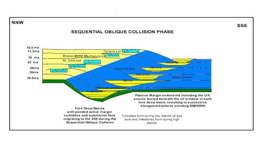
7 SEQUENTIAL OBLIQUE COLLISION (Late Oligocene-mid Miocene) Foredeep Basin Active Margin turbidites Source Rock Maturation Foreland Uplift Source for turbidities Foreland Fold and Thrust Belt Overthrusting Asymmetric Anticlines First Phase HC Accumulations
8
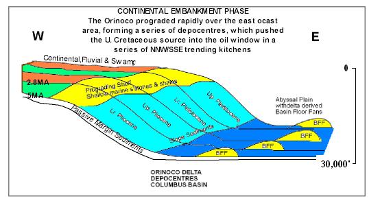
9 CONTINENTAL EMBANKMENT DELTA IN OPEN OCEAN (Pliocene-Present)
10 IDENTIFICATIONS OF SOURCE FIRST IDENTIFICATION by Persad et al. (1980) Naparima Hill and Gautier Formations found to be a rich oil prone mature source and to correlate with many produced oils OIL SOURCE CORRELATION CONFIRMED by Talukdar et al an 1995 SUBSEQUENT CONFIRMATIONS made by MANY AUTHORS

11 SOURCE TYPES Kerogen quality of these oil-prone source rocks varies considerably from type II to mixed type II/III. The Upper Cretaceous source becomes more marine in a NNW direction as evidenced by the Pristane/Phytane ratio Pristane/Phytane Ratio Map Control Well
12 MINOR TERTIARY SOURCE: ORGANIC FACIES AND THERMAL MATURITY Many of the Tertiary formations in Trinidad, ranging in age from Palaeocene to Pliocene (inland and offshore), contain abundant shales that have been evaluated for petroleum source potential Persad et ai., 1980; Leonard 1983; Rodriguez, 1988; Talukdar, Dow and Persad, 1989 All work showed they contain essentially gas-prone kerogen and are generally immature. The Brasso shales were however found to be an oil source in the Gulf of Paria, the only Tertiary source rock recognized Very minor production to date
13 OIL ALTERATIONS SEVERAL STUDIES BY TALUKDAR, PERSAD and/or DOW STARTING IN 1989 AND CONTINUING RECOGNISED THAT MOST TRINIDAD OILS ARE ALTERED AND THAT THERE ARE MAINLY TWO TYPES OF ALTERATION BIODEGRADATION and EVAPORATIVE FRACTIONATION THEY FURTHER RECOGNIZED THAT THERE MAY MULTIPLE PHASES OF ALTERATION
14 BIODEGRADATION LONG KNOWN AND EASILY RECOGNISED IT RESULTS IN: Decrease in API Gravity, GOR and light hydrocarbons content Increase in viscosity and sulphur content It is caused by oils coming into contact with meteoric water carrying aerobic microbes
15 N I 2 C 2 5 D M B N C 6 M 2 C 4 P BZ D M P 3 T M B 2 CH M H 2 3 D M 1 P 1 D M C P 3 1 M C H 3 D M C P 3 1 E T P 2 3 D M C P M C 1 H 1 3 T M C P M P X Y L N C 9 I P 1 0 N C 1 0 I P 1 1 O X Y L N C 1 1 I P 9 DESCRIPTION OF TYPES OF OIL ALTERATIONS BIODEGRADATION It is recognised by the character of the HRGCs A whole unaltered oil looks like this Whole Oil GC Trace G D This second oil was biodegraded, mixed with a later migrating condensate And then re-biodegraded I C 4N C 4 CP 2 3 M P 2 3 D M B N C 7 I S T D E C P T M C P T O L N C 8
16 DESCRIPTION OF TYPES OF OIL ALTERATIONS EVAPORATIVE FRACTIONATION A "residual" oil shows loss of light hydrocarbons and a reduced API gravity compared to the original oil and is waxier. The other petroleum fraction that has left the oil pool and migrated above is a condensate (known as evaporative condensate) and has a much higher API gravity. This condensate will have two characteristics. First, contrary to thermal condensates, it will have the same range of thermal maturity as the "residual" oil or any original oil from the same source in the area that escaped the introduction of gas and resulting fractionation. Secondly, contrary to the complementary "residual" oil, it will be enriched in light hydrocarbons. It will appear like an unaltered original condensate.
17 EVAPORATIVE FRACTIONATION In the Thompson diagram, the oils with evaporative fractionation show fractionation of the C7s compared to the original oils
18 EVAPORATIVE FRACTIONATION is recognized in the whole oil GC by the loss of light or low molecular weight hydrocarbons together with or accompanied by evaporative fractionation of the C7s
19 CONCEPT OF PETROLEUM SYSTEMS SEVERAL STUDIES BY TALUKDAR, PERSAD ET AL STARTING IN 1995 AND CONTINUING HAVE RECOGNISED AND DESCRIBED ELEVEN PETROLEUM SYSTEMS The concept of petroleum systems is discussed briefly next and then we list the systems identified by Persad and Talukdar et al and provide a brief description of the most prolific
20 PETROLEUM SYSTEMS The Concept of Petroleum Systems According to Magoon and Dow (1994) "a petroleum system encompasses a pod of active source rock and all related oil and gas and includes all the essential elements and processes that are needed for oil and gas accumulations to exist". These essential elements of a petroleum system are the source, reservoir, seal and overburden migration pathway. The processes are the timing of trap formation, generation, migration and accumulation of petroleum. Traps must have been formed at the correct time, i.e. prior to migration. This is defined in the petroleum systems approach as the critical moment.
21 Definition and Description of Petroleum System The petroleum system s name combines the name(s) of the reservoir rock(s) and the source rock or rocks with the level of certainty: e.g. The Gautier/Naparima Hill-Cruse/Forest/M L'Enfer (!) System The name includes first the source, followed by the reservoir, but separated by a hyphen. In each case the formations are given with the oldest first.
22 LISTING OF THE PETROLEUM SYSTEMS The eleven petroleum systems that have been identified by Talukdar et al are listed in the next slide on a basin by basin basis Each with its designation as known, hypothetical and/or speculative as the case may be The systems in yellow account for 99.99% of the oil produced to date and all share a common source, i.e. the Upper Cretaceous Naparima Hill and Gautier Formations.
23 SOUTHERN BASIN The Gautier/Naparima Hill-Cruse/Forest/M L'Enfer (!) System COLUMBUS BASIN The Gautier/Naparima Hill-Lower Cruse/Gros Morne/Mayaro (!) System FOLD AND THRUST BELT The Gautier/Naparima Hill-Cipero (!) System The Gautier/Naparima Hill-Angostura (.) System The Gautier/Naparima Hill-Cuche/Gautier/Naparima Hill (.) Petroleum System The Gautier/Naparima Hill-Naparima Hill (.) Petroleum System The Gautier/Naparima Hill-Pointe a Pierre/San Fernando ( ) System CARONI BASIN/GULF OF PARIA PULL APART BASIN The Gautier/Naparima Hill-Manzanilla/Springvale/Talparo (!) System The Cipero-Brasso/Manzanilla (!) Petroleum System CARUPANO BASIN (CARACOLITO SUB-BASIN and the PARIA SUB-BASIN) and THE EAST TOBAGO HALF-GRABEN The Cretaceous-Neogene ( ) Petroleum System
 System GEOGRAPHIC EXTENT This system is known to exist in the Southern Basin onshore and in its extension offshore in the Gulf of Paria.")
24 SOUTHERN BASIN The Gautier/Naparima Hill-Cruse/Forest/M L'Enfer (!) System GEOGRAPHIC EXTENT This system is known to exist in the Southern Basin onshore and in its extension offshore in the Gulf of Paria. It lies within the piggy back Southern Basin, which is subdivided into the western Erin Syncline, which lies west of the Los Bajos Fault, and extends westward into the Gulf of Paria, a central portion known as the Siparia Syncline and an eastern portion termed the Ortoire Syncline. OIL PRODUCTION It is the largest known contributor to oil production in the country having produced an estimated 1,900 million barrels of oil to the end of OOIP in these reservoirs/fields is estimated to be over eleven billion barrels
25 SOUTHERN BASIN The Gautier/Naparima Hill-Cruse/Forest/M L'Enfer (!) System The oil has re-migrated from deeper (most likely Herrera) reservoirs into the shallower Pliocene reservoirs (Talukdar et al 1989)

26 COLUMBUS BASIN Gautier/Naparima Hill Lower Cruse/Gros Morne/Mayaro (!) System GEOGRAPHIC EXTENT found mainly offshore the south and southern part of the east coast of Trinidad. A western onshore portion, lies to the south-east of the eastern part of the Southern Basin, and east of the Guayaguayare sub-basin. It extends as far north as the Darien Ridge and includes the Galeota Sub-basin. Its southern boundary extends beyond the territorial waters into Venezuela. Its eastern boundary is perhaps best defined as the eastern limit of the growth fault province of the Orinoco delta PETROLEUM ACCUMULATIONS This basin contains some of the largest petroleum accumulations known in the Trinidad area to date. There are oil fields, as well as gas/condensate fields with thinner oil legs below. The fields have produced over one billion barrels of oil and ten TCF of gas to date
27 FOLD AND THRUST BELT Within the fold and thrust belt area number of petroleum systems grouped together, because of the similarity of their origin and development. They all have the Naparima Hill and Gautier formations as their source. They are all caught up in the down-warping of the successive foredeep basins, which created a succession of elongate kitchens which caused the maturation of the source rocks. The migration and trapping of the oil and gas in the mid to lower Tertiary reservoirs represents the first phase of oil accumulations within all of these petroleum systems. The petroleum systems we described within the fold and thrust belt are: The Gautier/Naparima Hill-Cipero (!) System The Gautier/Naparima Hill-Angostura (.) System The Gautier/Naparima Hill-Cuche/Gautier/Naparima Hill (.) Petroleum System The Gautier/Naparima Hill-Naparima Hill (.) Petroleum System The Gautier/Naparima Hill-Pointe a Pierre/San Fernando () System Those in yellow account for all of the oil produced within the Fold and Thrust Belt to date

28 FOLD AND THRUST BELT GEOGRAPHIC EXTENT It underlies the entire Caroni Basin, onshore and offshore, where the GOPPA obscures its features. It is partly exposed in the Central Range Uplift, which is a local transpressive zone related to the east-west wrench movement. To the south, it is overlain in part by the piggy back Southern Basin, but outcrops locally in uplifts like the Rock Dome and Singuineau uplifts. It extends north-eastwards into the eastern offshore of Trinidad and westwards into the western Gulf of Paria and into eastern Venezuela.

29 FOLD AND THRUST BELT The Gautier/Naparima Hill-Cipero (!) System GEOGRAPHIC EXTENT Known to exist onshore southern Trinidad, south of the Central Range and westward into the Gulf of Paria. The reservoirs extend in three major fairways all trending north-east/south-west to ENE- WSW. They are from north to south, the Nariva fairway, the Retrench fairway and the Herrera Fairway. The latter can be sub-divided into Cipero and Karamat Herrera fairways. PRODUCTION Fields found have to date produced over 250 million barrels of oil.
 System GEOGRAPHIC EXTENT continued Potential extensions of these trends have been postulated by this author who has suggested that they could contain significant accumulations of")
30 FOLD AND THRUST BELT The Gautier/Naparima Hill-Cipero (!) System GEOGRAPHIC EXTENT continued Potential extensions of these trends have been postulated by this author who has suggested that they could contain significant accumulations of hydrocarbons. For example he has postulated a westward extension to the Herrera trend west of the Los Bajos Fault and into the western Gulf of Paria
 System GEOGRAPHIC EXTENT Known to lie within the transpressive zone of the Central Range Uplift, in the eastern offshore of Trinidad, at least in Blocks 2 and 3.")

31 FOLD AND THRUST BELT The Gautier/Naparima Hill-Angostura (.) System GEOGRAPHIC EXTENT Known to lie within the transpressive zone of the Central Range Uplift, in the eastern offshore of Trinidad, at least in Blocks 2 and 3. It may extend along trend to the south and to the southwest into the onshore of Trinidad The Angostura sands, which are lower to middle Oligocene, may outcrop in the eastern Central Range, where it is known as the Pointe a Pierre. May be active margin turbidites, or derived from the passive margin PETROLEUM PRODUCTION To March 2015 the Angostura Field has produced over 70 MM barrels oil and is currently producing 8,000 bopd and 222 MMCFGD
 Petroleum System GEOGRAPHIC EXTENT A hypothetical petroleum system Postulated to contain sub-marine fan reservoirs within the Caroni and Southern Basins and in")
 have discussed possible distribution of reservoirs and source rocks in the Cretaceous and their maps show the possible extent of")
32 FOLD AND THRUST BELT The Gautier/Naparima Hill-Cuche/Gautier/Naparima Hill (.) Petroleum System GEOGRAPHIC EXTENT A hypothetical petroleum system Postulated to contain sub-marine fan reservoirs within the Caroni and Southern Basins and in the Eastern offshore in the Manzanilla sub-basin. Not expected to be present in the Central Range where these formations outcrop. Erlich and Keens-Dumas (2007) have discussed possible distribution of reservoirs and source rocks in the Cretaceous and their maps show the possible extent of this system. PETROLEUM ACCUMULATIONS To date the only known oil accumulations are non-commercial ME 15 and Rocky Palace 1
 Petroleum System GEOGRAPHIC EXTENT Fractured argillites expected to be found within the southern area of the Central Range transpressive zone onshore and its eastward and westward extensions")
33 FOLD AND THRUST BELT The Gautier/Naparima Hill-Naparima Hill (.) Petroleum System GEOGRAPHIC EXTENT Fractured argillites expected to be found within the southern area of the Central Range transpressive zone onshore and its eastward and westward extensions offshore, as well as the entire Southern Basin and the Guayaguayare Sub-Basin. Portions missing because of uplift and erosion within the Central Range PETROLEUM ACCUMULATIONS No commercial accumulations found to date. Sub-commercial amounts of light oil were produced in various wells in Guayaguayare area e.g. Gu K 15.1 degrees API Heavy oil shows in Marabella 1 Minor gas in Esmeralda 1 Gas and condensate in Howler 1 POTENTIAL Significant unconventional shale oil potential

34 FOLD AND THRUST BELT The Gautier/Naparima Hill-Pointe a Pierre/San Fernando () System no correlation between source and reservoir. GEOGRAPHIC EXTENT... along the flanks of the Central Range Uplift PETROLEUM ACCUMULATIONS No commercial petroleum accumulations found to date An Eocene sand tested 4.53 MMCFGD at depths between 4855 and 4867 feet in Emerald 1, Block 3
35 CARONI BASIN/GULF OF PARIA PULL APART BASIN Two petroleum systems are known to within the Gulf of Paria portion of the Caroni Basin. The Gautier/Naparima Hill-Manzanilla/Springvale/Talparo (!) System The Cipero-Brasso/Manzanilla (!) Petroleum System
 System GEOGRAPHIC EXTENT Found in the southern portion of the Caroni Basin offshore in the Gulf of Paria and.")
36 CARONI BASIN/GULF OF PARIA PULL APART BASIN The Gautier/Naparima Hill-Manzanilla/Springvale/Talparo (!) System GEOGRAPHIC EXTENT Found in the southern portion of the Caroni Basin offshore in the Gulf of Paria and. It may extend into the southern portions of onshore and eastern offshore parts of the Caroni Basin. PETROLEUM ACCUMULATIONS Commercial production of over 200 million barrels of oil to date. Large heavy oil accumulations have been found totalling over 1.5 billion bbls OOIP.
 Petroleum System GEOGRAPHIC EXTENT Found in the southern portion of the Gulf of Paria Pull Apart Basin onshore in Eastern Venezueala.")
37 CARONI BASIN/GULF OF PARIA PULL APART BASIN The Cipero-Brasso/Manzanilla (!) Petroleum System GEOGRAPHIC EXTENT Found in the southern portion of the Gulf of Paria Pull Apart Basin onshore in Eastern Venezueala. We postulate its extension into the southern portions of onshore part of the Caroni Basin PETROLEUM ACCUMULATIONS Minor amount of very waxy light oil produced from the Couva Marine sourced from Brasso shales
38 The Cretaceous-Tertiary () Petroleum System GEOGRAPHIC EXTENT May be present in the entire Tobago Trough which extends from the Caracolito Sub-basin in the south-west to north of offshore west of Barbados, where oil of an U. Cretaceous marine source is being produced on the island of Barbados. It may also be present in parts of the Paria and Patao sub-basins. PETROLEUM ACCUMULATIONS 12 MMBO produced from the Woodbourne field, Barbados
39 The Tertiary-Neogene () Petroleum System GEOCHEMICAL ANALYSIS OF HIBISCUS CONDENSATE (Persad 2011)..revealed Tertiary source GEOGRAPHIC EXTENT Known to be present along parts of the Patao High (Hibiscus wells) and in the Rio Caribe and Patao wells Expected to be present in the Paria Sub-basin May extend eastward into the East Tobago Half Graben and the Barbados Basin. Speculated as being present in the entire Tobago Trough which extends from the Caracolito Sub-basin in the south-west to north of offshore west of Barbados.
 and in the Rio Caribe wells (richer).")
40 The Tertiary-Neogene () Petroleum System PETROLEUM ACCUMULATIONS This system is an exciting possibility as it points to a previously unknown source for liquid hydrocarbons even though it is lean. To this time liquids have been found in the Hibiscus Field (minor) and in the Rio Caribe wells (richer). The Rio Caribe wells tested 10 to 20 MMCFD of gas and 1000 to 2,000 barrels condensate per day No wells have been drilled into the flanks of the Tobago trough either in Trinidad waters to the south or Grenadian waters to the north but these areas are highly prospective for gas richer in condensate.
41 OTHER PETROLEUM SYSTEMS We have no doubt that other petroleum systems will be identified. There are three obvious candidates: 1. In the sub-salt i.e. below the evaporite known to be present in the Gulf of Paria Pull-apart Basin we can expect pre-cretaceous reservoirs and source rocks. 2. In the deeper horizons of the East Coast offshore we can expect to find reservoirs and source rocks in the syn-rift sediments of Lower cretaceous to Jurassic age, similar to what is found to the south-east in the Guyana-Suriname Basin and offshore Angola (which is our probable pre-rift counterpart to the east). 3. In the deeper horizons of the North Coast Marine Area we can expect to find reservoirs and source rocks in the syn-rift sediments of Lower Cretaceous to Jurassic age, similar to what is found to the north-west off-shore Yucatan and in the Gulf of Mexico (which are our pre-rift counterparts to the north and west).
42 FUTURE POTENTIAL A KNOWLEDGE OF PETROLEUM GEOCHEMISTRY HAS PROVIDED VALUABLE CLUES FOR FUTURE EXPLORATION IN TRINIDAD IN THREE MAIN AREAS DEEPER POOLS EXTENSIONS OF TRENDS FRONTIER AREAS
43 FUTURE POTENTIAL DEEPER POOLS ECMA COLUMBUS BASIN Talukdar et al ( years ago) predicted deeper pools of residual oil below gas/condensate fields in ECMA ALL (MECHANICALLY SUCCESSFUL) DEEPER POOL WELLS IN GAS/CONDENSATE FIELDS IN THE ECMA HAVE FOUND BLACK OIL BELOW eg MAHOGANY & IMMORTELLE/AMHERSTIA
44 HRGCs Immortelle Field Immortelle Shallow Very light fractionated condensate API 49.5 degrees Rich in light aromatics depleted in heavy waxy hydrocarbons Immortelle Deep Heavier condensate API 42.8 degrees enriched in waxy hydrocarbons. It is probably a residual oil
45 FUTURE POTENTIAL DEEPER POOLS EASTERN ONSHORE Persad, Talukdar and Ritson (2015) have identified deeper pool residual oil prospects (AND shallow evaporatively fractionated condensate prospects) in the Goudron Field based on analyses of fourteen oils from the field area

46 MOST WESTERN OILS ARE FRACTIONATED CONDENSATES.POTENTIAL FOR DEEPER RESIDUAL OILS NORTH-CENTRAL OIL IS RESIDUAL POTENTIAL FOR EVAPAORATIVE CONDENSATE NEARBY Group 1B Group 3 INDEX MAP Group 2 Grp. 2 Group 1A Group 4 Group 1A Mildly fractionated residual oil Group 1B Strongly fractionated residual oil Group 2 Mildly fractionated oil Group 3 Condensate mixed with Heavily biodegraded oil residue Group 4 Very heavily biodegraded oil

47 W NORTH-CENTRAL AREA POOL EXTENSION PROSPECTS E 7K bbls residual oil 5K bbls residual oil Earlier operator found strong oil indications at surface east of Gy 658. We interpret primary migration from Up. Cretaceous source rocks into Gros Morne Sands and re-migration (EVAPORATIVELY FRACTIONATED OILS) into Goudron Sands

48 FUTURE POTENTIAL SOUTHERN ONSHORE and GULF OF PARIA DEEP HERRERA POTENTIAL (TURBIDITES)
49 FUTURE POTENTIAL EXTENSIONS OF TRENDS e.g. SOUTH WEST PENINSULA GEOCHEMICAL ANALYSES OF PRODUCED OILS AND OILS EXTRACTED FROM MUD VOLANO EJECTA IN THE SWP HAVE POINTED TO POTENTIALLY HUGE DEEP OIL ACCUMULATIONS IN BOLT s CEDROS ACREAGE SUPPORTED BY 3D SEISMIC, DRILLING AND NOW BY SURFACE GEOCHEMISTRY
50 Galpha Pt.( & Islote Pt.) Mud volcano has ejected blocks of Herrera oil sand Geochemically analysed as light residual oil Bonasse oils analysed as fractionated oils confirming deep potential

51 LARGE DEEP PROSPECT IDENTIFIED BY SEISMIC, DRILLING, PRODUCED OILS,SURFACE GEOCHEMISTRY & OIL EXTRACTED FROM MUD VOLCANO The entire area shows a strong microbial anomaly. There are also elevated concentrations of methane through butane, and fluorescence in the southern part of the area Bonasse Field Cedros - Icacos Area Trinidad and Tobago icrobial Populations for Beach Oilfield Limited by Schumacher & Associates and GeoFrontiers Corporation October Meters Map Scale: 1:75,000 Coordinates: UTM Zone 20, WGS84 Landsat 8 Image colloected 7 September Microbial CFU/mg
52 FUTURE POTENTIAL FRONTIER AREAS IDENTIFICATION OF THE PETROLEUM SYSTEMS IN THE TOBAGO BASINS AND THE ECMA HAS LESSENED EXPLORATION RISK

53 The Cretaceous-Tertiary () Petroleum System May be present in the entire Tobago Trough The Tertiary-Neogene () Petroleum System May be present in the entire Tobago Trough, Patao High, Paria Sub-Basin, East Tobago Half Graben and Barbados Basin
54 MAJOR POTENTIAL FOLD & THRUST BELT COLUMBUS FOREDEEP BASIN TOE THRUST BELT EAST COAST MARINE AREAS
55 QUESTIONS
ABSTRACT VENEZUELA TRINIDAD CARIBBEAN OBLIQUE COLLISION MODEL REVISED. Roger Higgs, Geoclastica Ltd, UK
 THE 4 TH GEOLOGICAL CONFERENCE OF THE GEOLOGICAL SOCIETY OF TRINIDAD AND TOBAGO June 17-22, 2007, Hilton Trinidad & Conference Centre Port-of-Spain, Trinidad and Tobago Caribbean Exploration Planning for
Hydrocarbon Charge Analysis of the SECC Block, Columbus Basin, Trinidad and Tobago
 Transactions of the 16 th Caribbean Geological Conference, Barbados. Caribbean Journal of Earth Science, 39 (2005), 21-27. Geological Society of Jamaica. Hydrocarbon Charge Analysis of the SECC Block,
Fluvial-Estuarine and Deltaic Reservoirs, Shelf Margin Delta and Slope Reservoir Characteristics Philip Sedore 2015
 Fluvial-Estuarine and Deltaic Reservoirs, Shelf Margin Delta and Slope Reservoir Characteristics Philip Sedore 2015 Introduction The offshore Columbus Basin and the onshore Southern Basin of Trinidad are
MUHAMMAD S TAMANNAI, DOUGLAS WINSTONE, IAN DEIGHTON & PETER CONN, TGS Nopec Geological Products and Services, London, United Kingdom
 Geological and Geophysical Evaluation of Offshore Morondava Frontier Basin based on Satellite Gravity, Well and regional 2D Seismic Data Interpretation MUHAMMAD S TAMANNAI, DOUGLAS WINSTONE, IAN DEIGHTON
Blocks 31, 32, 33, 34, 35 & 36/03 Southeast Offshore Vietnam
 Blocks 31, 32, 33, 34, 35 & 36/03 Southeast Offshore Vietnam Block 31 32 33 34 35 36/03 Area (km 2) 5,036 4,440 4,630 4,700 4,630 2,950 Sea level (m) 20 20-30 30-40 50 50 50 Seismic 2D (km) 1,294 685 431
A comparison of structural styles and prospectivity along the Atlantic margin from Senegal to Benin. Peter Conn*, Ian Deighton* & Dario Chisari*
 A comparison of structural styles and prospectivity along the Atlantic margin from Senegal to Benin Overview Peter Conn*, Ian Deighton* & Dario Chisari* * TGS, Millbank House, Surbiton, UK, KT6 6AP The
Meandering Miocene Deep Sea Channel Systems Offshore Congo, West Africa
 Meandering Miocene Deep Sea Channel Systems Offshore Congo, West Africa S. Baer* (PGS), J. E. Comstock (PGS), K. Vrålstad (PGS), R. Borsato (PGS), M. Martin (PGS), J.P. Saba (SNPC), B. Débi-Obambé (SNPC)
B.C. s Offshore Oil and Gas: a Guide to the Geology and Resources.
 B.C. s Offshore Oil and Gas: a Guide to the Geology and Resources. Introduction Beneath the offshore regions of British Columbia are four moderately large, geologically young sedimentary basins (Figure
Controls on clastic systems in the Angoche basin, Mozambique: tectonics, contourites and petroleum systems
 P2-2-13 Controls on clastic systems in the Angoche basin, Mozambique: tectonics, contourites and petroleum systems Eva Hollebeek, Olivia Osicki, Duplo Kornpihl Schlumberger, London, UK Introduction Offshore
Vail et al., 1977b. AAPG 1977 reprinted with permission of the AAPG whose permission is required for further use.
 Well 5 Well 4 Well 3 Well 2 Well 1 Vail et al., 1977b AAPG 1977 reprinted with permission of the AAPG whose permission is required for further use. Well 5 Well 4 Well 3 Well 2 Well 1 Vail et al., 1977b
EGAS. Ministry of Petroleum
 EGAS Ministry of Petroleum EGAS Ministry of Petroleum About The Block Location: N. Thekah offshore block is located at about 56 km to the north of the Mediterranean shore line, 85 km to the north west
EGAS. Ministry of Petroleum
 EGAS Ministry of Petroleum EGAS Ministry of Petroleum About The Block Location: N. El Arish offshore block is located in the extreme eastern part of the Egypt s economic water border and bounded from the
BALOCHISTAN FOLDBELT BASIN
 INTRODUCTION BALOCHISTAN FOLDBELT BASIN The Kharan-3 block is located in the Kharan Trough of Balochistan Basin. GEOLOGICAL SETTING The Balochistan Province is an Upper Cretaceous to Recent structurally
Luderitz Basin, Offshore Namibia: Farm-out Opportunity. APPEX, London, March 2015 Graham Pritchard, Serica Energy plc
 Luderitz Basin, Offshore Namibia: Farm-out Opportunity APPEX, London, March 2015 Graham Pritchard, Serica Energy plc Serica Luderitz Basin Namibia Introduction Serica (85%, operator) 17,384 km 2 acreage
Sedimentary Cycle Best Practice: Potential Eo-Oligocene Sediments in Western Indonesia*
 Sedimentary Cycle Best Practice: Potential Eo-Oligocene Sediments in Western Indonesia* Mellinda Arisandy 1 and I Wayan Darma 1 Search and Discovery Article #11008 (2017)** Posted November 6, 2017 *Adapted
SouthWest Energy (HK) Ltd.
 Ltd.") SouthWest Energy (HK) Ltd. Investor Presentation Cape Town October 2012 Why Are We Searching Oil in SWE Blocks? Similar geological g setting with Yemen s producing fields Oil seeps and oil show in the
SouthWest Energy (HK) Ltd. Investor Presentation Cape Town October 2012 Why Are We Searching Oil in SWE Blocks? Similar geological g setting with Yemen s producing fields Oil seeps and oil show in the
Ministry of Oil and Minerals Petroleum Exploration & Production Authority BLOCK 85 (Al Uqlah North)
") Ministry of Oil and Minerals Petroleum Exploration & Production Authority BLOCK 85 (Al Uqlah North) The Al Uqlah North Block (85) occupies an area of 597 km 2 in the Sabatayn Basin in the province of Shabwah
Ministry of Oil and Minerals Petroleum Exploration & Production Authority BLOCK 85 (Al Uqlah North) The Al Uqlah North Block (85) occupies an area of 597 km 2 in the Sabatayn Basin in the province of Shabwah
Ministry of Oil and Minerals Petroleum Exploration & Production Authority BLOCK 80 (WADI SARR)
") Ministry of Oil and Minerals Petroleum Exploration & Production Authority BLOCK 80 (WADI SARR) The Wadi Sarr Block (80) occupies an area of 1961 km 2 on the Sayun- Masilah Basin in the central Yemen. Block
Ministry of Oil and Minerals Petroleum Exploration & Production Authority BLOCK 80 (WADI SARR) The Wadi Sarr Block (80) occupies an area of 1961 km 2 on the Sayun- Masilah Basin in the central Yemen. Block
Kilometre-Scale Uplift of the Early Cretaceous Rift Section, Camamu Basin, Offshore North-East Brazil*
 Kilometre-Scale Uplift of the Early Cretaceous Rift Section, Camamu Basin, Offshore North-East Brazil* Iain Scotchman 1 and Dario Chiossi 2 Search and Discovery Article #50183 (2009) Posted May 20, 2009
East Africa Transform Margin The View from Tanzania and Madagascar
 East Africa Transform Margin The View from Tanzania and Madagascar Richard Higgins and Mark Sofield 10 th PESGB/HGS Conference on African E & P, London, September 7-8, 2011 Acknowledgements Legal Notice:
THE NORTH SUMATERA BASIN : GEOLOGICAL FRAMEWORK & PETROLEUM SYSTEM REVIEW
 THE NORTH SUMATERA BASIN : GEOLOGICAL FRAMEWORK & PETROLEUM SYSTEM REVIEW By the Delegation of Indonesia : Bambang Wicaksono TM* Jonathan Setyoko H* Hermes Panggabean** * Lemigas ** PSG Krabi, 12-15 May
Petroleum Prospectivity in the Namibe and Southern Benguela Basins, Offshore Angola
 Petroleum Prospectivity in the Namibe and Southern Benguela Basins, Offshore Angola C. Koch* (PGS), F. Pepe (PGS), R. Vasconcelos (PGS), F. Mathew (PGS), R. Borsato (PGS) & M.P.C. de Sá (Sonangol) SUMMARY
The Late Tertiary Deep-Water Siliciclastic System of the Levant Margin - An Emerging Play Offshore Israel*
 The Late Tertiary Deep-Water Siliciclastic System of the Levant Margin - An Emerging Play Offshore Israel* Michael A. Gardosh 1, Yehezkel Druckman 2 and Binyamin Buchbinder 2 Search and Discovery Article
RELINQUISHMENT REPORT FOR LICENCE P.1663, BLOCK 29/4b and 29/5e
 RELINQUISHMENT REPORT FOR LICENCE P.1663, BLOCK 29/4b and 29/5e Licence: P.1663 Blocks: 29/4b & 29/5e 25th Round Traditional Licence Operator: Ithaca Energy UK(Ltd) 100% Work Programme Summary The agreed
Key Elements of the Petroleum Systems of the Rockall and Slyne-Erris Basins
 Key Elements of the Petroleum Systems of the Rockall and Slyne-Erris Basins Bandon Corrib Dooish Atlantic Ireland Conference, Dublin, 1 st - 2 nd November 2016 Rockall and Slyne-Erris Basins Only 11 exploration
RWE Dea UK SNS Limited (50%), Faroe Petroleum (UK) Limited
, Faroe Petroleum (UK) Limited") 1. Licence information Licence Number P1975 Licence Round 27 th (2012) Licence Type Traditional Blocks 3/28c & 9/3e Licensees Work Programme 2. Synopsis RWE Dea UK SNS Limited (50%), Faroe Petroleum (UK)
1. Licence information Licence Number P1975 Licence Round 27 th (2012) Licence Type Traditional Blocks 3/28c & 9/3e Licensees Work Programme 2. Synopsis RWE Dea UK SNS Limited (50%), Faroe Petroleum (UK)
Depositional History and Petroleum Potential of Ombilin Basin, West Sumatra - Indonesia, Based on Surface Geological Data*
 Depositional History and Petroleum Potential of Ombilin Basin, West Sumatra - Indonesia, Based on Surface Geological Data* Yahdi Zaim 1, Litto Habrianta 2, Chalid I. Abdullah 1, Aswan 1, Yan Rizal 1, Nurcahyo
Petroleum Field Methods Course: Trinidad. Summary Report. Submitted to: Offshore Energy Research Association of Nova Scotia (OERA) to fulfill
 to fulfill") Petroleum Field Methods Course: Trinidad Summary Report Submitted to: Offshore Energy Research Association of Nova Scotia (OERA) to fulfill the requirements of the Undergraduate Student Research Travel
Petroleum Field Methods Course: Trinidad Summary Report Submitted to: Offshore Energy Research Association of Nova Scotia (OERA) to fulfill the requirements of the Undergraduate Student Research Travel
Debra K. Gomez 1 and David Brewster 2. Search and Discovery Article #10843 (2016)** Posted March 21, Abstract
** Posted March 21, Abstract") PS Petroleum Potential Onshore Southern Madagascar, Morandava Basin, Block 3114* Debra K. Gomez 1 and David Brewster 2 Search and Discovery Article #10843 (2016)** Posted March 21, 2016 *Adapted from poster
PS Petroleum Potential Onshore Southern Madagascar, Morandava Basin, Block 3114* Debra K. Gomez 1 and David Brewster 2 Search and Discovery Article #10843 (2016)** Posted March 21, 2016 *Adapted from poster
Geology & Geophysics Applied in Industry. EXERCISE 2: A Quick-Look Evaluation
 EXERCISE 2: A Quick-Look Evaluation You have been asked to perform a quick back-of-the-envelope evaluation of the blocks being offered off of Somewhereia. Is there enough potential that our company should
Petroleum Systems (Part One) Source, Generation, and Migration
 Source, Generation, and Migration") Petroleum Systems (Part One) Source, Generation, and Migration GEOL 4233 Class January 2008 Petroleum Systems Elements Source Rock Migration Route Reservoir Rock Seal Rock Trap Processes Generation Migration
Petroleum Systems (Part One) Source, Generation, and Migration GEOL 4233 Class January 2008 Petroleum Systems Elements Source Rock Migration Route Reservoir Rock Seal Rock Trap Processes Generation Migration
Maturity Modeling of Gomin and South Gomin fields Southern Pattani Basin, Gulf of Thailand
 Maturity Modeling of Gomin and South Gomin fields Southern Pattani Basin, Gulf of Thailand Patinya Jaithan Petroleum Geoscience Program, Department of Geology, Faculty of Science, Chulalongkorn University,
Structural Geology of the Mountains
 Structural Geology of the Mountains Clinton R. Tippett Shell Canada Limited, Calgary, Alberta clinton.tippett@shell.ca INTRODUCTION The Southern Rocky Mountains of Canada (Figure 1) are made up of several
Colombia s Offshore*
 PS A Seismic-Structural Interpretation, on the Identification of Possible Causes in the Formation of Gas Chimneys in Colombia s Offshore* Tatiana Mayorga 1, Andrés E. Calle 2, Freddy M. Niño 2, Jorge Rubiano
Licence P1368: Relinquishment Report (end of 2 nd term) Hurricane Exploration PLC
 Hurricane Exploration PLC") Licence P1368: Relinquishment Report (end of 2 nd term) Hurricane Exploration PLC March 2012 1. Header Licence Number: P1368 Licence Round: 23 rd Licence Type: Frontier Block Numbers: 202/4, 202/5, 204/30,
Licence P1368: Relinquishment Report (end of 2 nd term) Hurricane Exploration PLC March 2012 1. Header Licence Number: P1368 Licence Round: 23 rd Licence Type: Frontier Block Numbers: 202/4, 202/5, 204/30,
Petroleum geology framework, West Coast offshore region
 Petroleum geology framework, West Coast offshore region James W. Haggart* Geological Survey of Canada, Vancouver, BC jhaggart@nrcan.gc.ca James R. Dietrich Geological Survey of Canada, Calgary, AB and
Ministry of Oil and Minerals Petroleum Exploration & Production Authority BLOCK 6 (Iryam)
") Ministry of Oil and Minerals Petroleum Exploration & Production Authority BLOCK 6 (Iryam) The Iryam Block (6) occupies an area of 3,911 km 2 in the Sabatayn Basin in the province of Shabwah in central
Ministry of Oil and Minerals Petroleum Exploration & Production Authority BLOCK 6 (Iryam) The Iryam Block (6) occupies an area of 3,911 km 2 in the Sabatayn Basin in the province of Shabwah in central
KENYA ONSHORE, LAMU BASIN Block L14 FARM- IN OPPORTUNITY
 KENYA ONSHORE, LAMU BASIN Block L14 FARM- IN OPPORTUNITY Lamu Oil and Gas, a joint venture between QFB and Edgo Energy, is seeking one or more partners, to continue exploration of their highly attractive
REGIONAL GEOLOGY IN KHMER BASIN
 CONTENTS 1-Khmere Basin 2-Regional Geology Khmer Basin 3-Regime Tectonic 4-Seismic Database -a/ Acquisition Data -b/ Prospect Angkor -C/ Cross Section Seismic 5-Play Type -a/ Play Schematic -b/ Structure
Hydrocarbon Potential of Jurassic Source Rock in the Guiana-Suriname Basin*
 Hydrocarbon Potential of Jurassic Source Rock in the Guiana-Suriname Basin* Clyde P. Griffith 1 Search and Discovery Article #10941 (2017)** Posted May 15, 2017 *Adapted from oral presentation given at
Israel: Seeing Deeper Imaging new play concepts with Clari-Fi broadband reprocessing
 Israel: Seeing Deeper Imaging new play concepts with Clari-Fi broadband reprocessing Alex Birch-Hawkins Interpretation Geophysicist 12 th December 2016 Contents TGS in Israel Geological Overview Exploration
USU 1360 TECTONICS / PROCESSES
 USU 1360 TECTONICS / PROCESSES Observe the world map and each enlargement Pacific Northwest Tibet South America Japan 03.00.a1 South Atlantic Arabian Peninsula Observe features near the Pacific Northwest
Migration Lag - What is it and how it affects Charge Risk and Fluid Properties*
 Migration Lag - What is it and how it affects Charge Risk and Fluid Properties* Zhiyong He 1 Search and Discovery Article #42014 (2017)** Posted February 20, 2017 *Adapted from oral presentation given
Figure 1 Extensional and Transform Fault Interaction, Influence on the Upper Cretaceous Hydrocarbon System, Equatorial Margin, West Africa.
 Figure 1 Extensional and Transform Fault Interaction, Influence on the Upper Cretaceous Hydrocarbon System, Equatorial Margin, West Africa. Presented to the 10th PESGB/HGS Conference on Africa E + P September
Unlocking the Exploration Potential and Petroleum Prospectivity of Barbados Offshore Acreage
 Unlocking the Exploration Potential and Petroleum Prospectivity of Barbados Offshore Acreage Jamar White Director Natural Resources Department Division of Energy and Telecommunications Government of Barbados
APPENDIX C GEOLOGICAL CHANCE OF SUCCESS RYDER SCOTT COMPANY PETROLEUM CONSULTANTS
 APPENDIX C GEOLOGICAL CHANCE OF SUCCESS Page 2 The Geological Chance of Success is intended to evaluate the probability that a functioning petroleum system is in place for each prospective reservoir. The
Geologic Trips San Francisco and the Bay Area
 Excerpt from Geologic Trips San Francisco and the Bay Area by Ted Konigsmark ISBN 0-9661316-4-9 GeoPress All rights reserved. No part of this book may be reproduced without written permission in writing,
Earth Science, (Tarbuck/Lutgens) Chapter 10: Mountain Building
 Chapter 10: Mountain Building") Earth Science, (Tarbuck/Lutgens) Chapter 10: Mountain Building 1) A(n) fault has little or no vertical movements of the two blocks. A) stick slip B) oblique slip C) strike slip D) dip slip 2) In a(n) fault,
Earth Science, (Tarbuck/Lutgens) Chapter 10: Mountain Building 1) A(n) fault has little or no vertical movements of the two blocks. A) stick slip B) oblique slip C) strike slip D) dip slip 2) In a(n) fault,
Building for the Future with Global Knowledge and Dedicated Skills. Jan Maier North Africa Capital Markets Day
 Building for the Future with Global Knowledge and Dedicated Skills Jan Maier North Africa 1 Core Plays: Recent and Current Exploration in North Africa Sirte Basin Matruh Basin CORE PLAYS Fold Belts Rift
Education Days Moscow Closing Session
 Education Days Moscow 2013 Basin and Petroleum Systems Modelling: Applications for Conventional and Unconventional Petroleum Exploration Risk and Resource Assessments By Dr Bjorn Wygrala Schlumberger 21-22
Petroleum Systems of the San Joaquin Basin: Characterization of Oil and Gas Types
 Stanford University BPSM Industrial Affiliates Summer Meeting July 28, 2008 Petroleum Systems of the San Joaquin Basin: Characterization of Oil and Gas Types Les Magoon = References Lillis, P.G., and Magoon,
PETROLEUM GEOLOGY AND GEOPHYSICS OF THE MOZAMBIQUE CHANNEL ANNOUNCEMENT
 PETROLEUM GEOLOGY AND GEOPHYSICS OF THE MOZAMBIQUE CHANNEL ANNOUNCEMENT Rusk, Bertagne & Associates are pleased to announce the completion of a three year study and the publication of a report entitled
Airborne gravity gradiometer surveying of petroleum systems under Lake Tanganyika, Tanzania
 Airborne gravity gradiometer surveying of petroleum systems under Lake Tanganyika, Tanzania D. Roberts Beach Energy P. Roy Chowdhury CGG S. J. Lowe CGG A. N. Christensen CGG Outline Introduction Geology
Hydrocarbon Potential of the Marginal Fields in Niger Delta Oza Field, a case study*
 Hydrocarbon Potential of the Marginal Fields in Niger Delta Oza Field, a case study* J.N. Sahu 1, C.H.V. Satya Sai 1, V. Chintamani 1 and C. Vishnu Vardhan 1 Search and Discovery Article #20182 (2012)*
Development of Petroleum Systems in Northern Alaska Timing of Petroleum System Events Controls Presence of Accumulations*
 Development of Petroleum Systems in Northern Alaska Timing of Petroleum System Events Controls Presence of Accumulations* Oliver Schenk 1, Kenneth J. Bird 2, Kenneth E. Peters 3, and Leslie B. Magoon 2
Main Challenges and Uncertainties for Oil Production from Turbidite Reservoirs in Deep Water Campos Basin, Brazil*
 Main Challenges and Uncertainties for Oil Production from Turbidite Reservoirs in Deep Water Campos Basin, Brazil* Carlos H. Bruhn 1, Antonio Pinto 1, and Paulo R. Johann 1 Search and Discovery Article
2.1. Central Indus Basin:
 14 2.1. Central Indus Basin: Research area lies in the Central Indus Basin of Pakistan. Central Indus Basin may be divided into following broad tectonic divisions from east to west (Kadri, 1995) (1) Punjab
Arc-Continent Collision: A Comparison of the SE Caribbean and Taiwan-Ryukyu Margins*
 Arc-Continent Collision: A Comparison of the SE Caribbean and Taiwan-Ryukyu Margins* Paddy Chesterman 1 Search and Discovery Article #30139 (2010) Posted November 30, 2010 *Adapted from oral presentation
Relinquishment Report Licence P1834
 Valiant Causeway Limited, March 2013 1. Header Licence Number: P1834 Licence Round: 26th Round Licence Type: Traditional Block Number: 204/21, 22b, 23b & 26a Partners: Valiant 100% (Operator) 2. Synopsis
eni s.p.a. upstream & technical services
 eni s.p.a. upstream & technical services 2013-2014 Master in Petroleum Engineering and Operations Congo & Angola Offshore-Congo River Basin Characteristics, exploitation approach and fields analogues Author:
Overview of Selected Shale Plays in New Mexico*
 Overview of Selected Shale Plays in New Mexico* Ron Broadhead 1 Search and Discovery Article #10627 (2014)** Posted August 18, 2014 *Adapted from presentation at RMAG luncheon meeting, Denver, Colorado,
Dr. Kenneth B. Taylor, P.G.
 North Carolina Forestry Association 2013 Annual Meeting October 3, 2013 Shale Gas 101: Natural Gas Exploration / Development: A North Carolina Perspective presented by Dr. Kenneth B. Taylor, P.G. State
Perspectives from Offshore Argentina & Uruguay
 Perspectives from Offshore Argentina & Uruguay A Prospectivity Overview Hannah Kearns October 2018 Introduction Argentina Offshore License Round 1 14 blocks Argentina North, 24 Austral-Malvinas Offshore
Horizontal Well Injector/Producer Pair Platong Field, Pattani Basin, Thailand*
 Horizontal Well Injector/Producer Pair Platong Field, Pattani Basin, Thailand* Abhiphat Pakdeesirote 1, Sonchawan Ackagosol 3, Sarayoot Geena 3, Nualjun Kitvarayut 3, Kenneth Lewis 2, Tom Tran 3, Nancy
History of geology and research of the Jan Mayen Micro-Continent and its associated exploration risks.
 History of geology and research of the Jan Mayen Micro-Continent and its associated exploration risks. Anett Blischke, Iceland GeoSurvey Þórarinn S. Arnarson, Karl Gunnarsson, Iceland GeoSurvey The North-Dreki
Figure 1: Location and bathymetry of the study area. Gulf of Guinea. Cameroon. Congo. Gabon. PGS/DGH Gabon MegaSurvey Coverage (35000Km 2 ) Eq.
 Eq.") Deepwater hydrocarbon prospectivity analysis of offshore North and South Gabon Muhammad S Tamannai (*), Thomas Hansen (1), Ron Borsato (1), Jennifer Greenhalgh (1) Martial-Rufin Moussavou (2) & Landry
Deepwater hydrocarbon prospectivity analysis of offshore North and South Gabon Muhammad S Tamannai (*), Thomas Hansen (1), Ron Borsato (1), Jennifer Greenhalgh (1) Martial-Rufin Moussavou (2) & Landry
Exploration Opportunities in the Middle East
 Exploration Opportunities in the Middle East Richard Herbert R Herbert Associates Ltd Finding Petroleum Middle East Forum Tuesday 16 th May 2017 The Geological Society, London Agenda What defines the Middle
Vertical Hydrocarbon Migration at the Nigerian Continental Slope: Applications of Seismic Mapping Techniques.
 ROAR HEGGLAND, Statoil ASA, N-4035 Stavanger, Norway Vertical Hydrocarbon Migration at the Nigerian Continental Slope: Applications of Seismic Mapping Techniques. Summary By the use of 3D seismic data,
Dalhousie University- Petroleum Geoscience Field Methods- Trinidad Summary Report
 Dalhousie University- Petroleum Geoscience Field Methods- Trinidad Summary Report Submitted to: Offshore Energy Research Association of Nova Scotia (OERA) To fulfill requirements of the Undergraduate Student
Today s oil is yesterday s plankton
 Oil and Gas Basics 2 Today s oil is yesterday s plankton Small marine and lake organisms live in surface waters They die, fall to the bottom and get buried into an organic rich sedimentary layer If geologic
Tetsuya Fujii. Bachelor of Geology, Shinshu University, Japan Master of Geophysics, the University of Tokyo, Japan
 USING 2D AND 3D BASIN MODELLING AND SEISMIC SEEPAGE INDICATORS TO INVESTIGATE CONTROLS ON HYDROCARBON MIGRATION AND ACCUMULATION IN THE VULCAN SUB-BASIN, TIMOR SEA, NORTH-WESTERN AUSTRALIA By Tetsuya Fujii
Case Study of the Structural and Depositional-Evolution Interpretation from Seismic Data*
 Case Study of the Structural and Depositional-Evolution Interpretation from Seismic Data* Yun Ling 1, Xiangyu Guo 1, Jixiang Lin 1, and Desheng Sun 1 Search and Discovery Article #20143 (2012) Posted April
Petroleum Geology and Exploration History of the Mergui Basin, THAILAND EPPM (P1) PROJECT
 PROJECT") Petroleum Geology and Exploration History of the Mergui Basin, THAILAND EPPM (P1) PROJECT KRABI, THAILAND 12 th May 2009 Contents of Presentation 1. Exploration History 1. Exploration History 2. General
Petroleum Geology and Exploration History of the Mergui Basin, THAILAND EPPM (P1) PROJECT KRABI, THAILAND 12 th May 2009 Contents of Presentation 1. Exploration History 1. Exploration History 2. General
Bulletin of Earth Sciences of Thailand. Evaluation of the Petroleum Systems in the Lanta-Similan Area, Northern Pattani Basin, Gulf of Thailand
 Evaluation of the Petroleum Systems in the Lanta-Similan Area, Northern Pattani Basin, Gulf of Thailand Sirajum Munira Petroleum Geoscience Program, Department of Geology, Faculty of Science, Chulalongkorn
Determination of Geothermal Gradient in the Eastern Niger Delta Sedimentary Basin from Bottom Hole Temperatures
 Journal of Earth Sciences and Geotechnical Engineering, vol. 4, no. 3, 2014, 109-114 ISSN: 1792-9040 (print), 1792-9660 (online) Scienpress Ltd, 2014 Determination of Geothermal Gradient in the Eastern
Petroleum Potential of the Application Area L12-4
 Petroleum Potential of the Application Area L12-4 The Application Area (L12-4) is underlain by the western Officer Basin, beneath the Gunbarrel Basin. The general basin architecture is outlined in Figure
Tim Carr - West Virginia University
 GEOGRAPHIC EXTENT OF PETROLEUM SYSTEM A Trap Trap Trap A STRATIGRAPHIC EXTENT OF PETROLEUM SYSTEM Petroleum accumulation Top of oil window Bottom of oil window Overburden Seal Reservoir Source Underburden
Abstract. Introduction. Regional Setting. GCSSEPM to be published December 2003
 Shelf Margin Deltas and Associated Deepwater Deposits: Implications on Reservoir Distribution and Hydrocarbon Entrapment, Block VI-1, Ulleung Basin, East Sea, South Korea Sneider, John S. Sneider Exploration,
December 21, Chapter 11 mountain building E.notebook. Feb 19 8:19 AM. Feb 19 9:28 AM
 Mountains form along convergent plate boundaries. Typically (usually) if you look at a mountain range, you know that it is at a plate boundary (active continental margin) or has been some time in the past
ONSHORE / OFFSHORE & NEW SHALE POTENTIAL OF MOROCCO
 Kingdom of Morocco ONSHORE / OFFSHORE & NEW SHALE POTENTIAL OF MOROCCO Mr M. NAHIM Mrs N. ESSALLOUMI Key aspects of Morocco Political and economic stability; Economic policy of integration at regional
Offshore Neogene Plays, Salina del Istmo Basin, Southeast of Mexico
 Offshore Neogene Plays, Salina del Istmo Basin, Southeast of Mexico ROBLES-NOLASCO, J.; PLIEGO-VIDAL, E.; TOLEDO-BANTE, C.; PIMIENTA-LUGO, M.; ORTEGA-GONZALEZ, V.; MARTINEZ-PEÑA, B. and HEREDIA-CERVANTES,
Using Thermal Maturity to Identify the Most Productive Part of the Oil Window to Target in the Woodford Shale
 2 nd Annual Woodford Liquids-Rich January 28, 2015 Horizontal Targets Congress 2015 Using Thermal Maturity to Identify the Most Productive Part of the Oil Window to Target in the Woodford Shale Brian J.
RELINQUISHMENT REPORT. License P1546 Block April 2009
 RELINQUISHMENT REPORT License P1546 Block 110-01 14 April 2009 Sherritt International Oil and Gas Limited 2000, 425-1 st street S.W., Calgary, Alberta Canada T2P 3L8 Telephone (403) 260-2900 Fax (403)
Geologic influence on variations in oil and gas production from the Cardium Formation, Ferrier Oilfield, west-central Alberta, Canada
 Geologic influence on variations in oil and gas production from the Cardium Formation, Ferrier Oilfield, west-central Alberta, Canada Marco Venieri and Per Kent Pedersen Department of Geoscience, University
For personal use only
 ASX ANNOUNCEMENT 11 September 2018 Billion Barrel Oil Potential Assessed in Pancontinental s PEL 87 Offshore Namibia Giant* scale oil potential in multiple Large Leads in PEL 87 Vast Cretaceous Superfan
ANGOLA OFFSHORE LICENSING 2007 BLOCK 46
 AGOLA OFFHOR LICIG 2007 BLOCK 46 DATA BA AVAILABILITY Figure 1 shows the seismic data available on Block 46. Fig. 1 Commercial 2D surveys: esterngeco: 794 km. GX Technology: 116 km. Commercial 3D surveys:
Karoon Awarded Exploration Permit EPP46 in Australia s Most Active Exploration Province, the Ceduna Sub Basin, Great Australian Bight
 7 October 2016 ASX Announcement Karoon Awarded Exploration Permit EPP46 in Australia s Most Active Exploration Province, the Ceduna Sub Basin, Great Australian Bight Karoon Gas Australia Ltd (ASX: KAR)
Geologic Structures. Changes in the shape and/or orientation of rocks in response to applied stress
 Geologic Structures Changes in the shape and/or orientation of rocks in response to applied stress Figure 15.19 Can be as big as a breadbox Or much bigger than a breadbox Three basic types Fractures >>>
DEEP WATER WEST COAST INDIA THE OPENING OF A NEW PLAY BENEATH THE DECCAN BASALTS
 DEEP WATER WEST COAST INDIA THE OPENING OF A NEW PLAY BENEATH THE DECCAN BASALTS Glyn Roberts 1, Charles Harmer 2, Ken Rutherford 3, Colin O Brien 4 1 Consultant, UK; 2 Spectrum Geo, UK; 3 Rutherford Exploration
Devonian Petroleum Systems and Exploration Potential, Southern Alberta, Part 3 Core Conference
 Devonian Petroleum Systems and Exploration Potential, Southern Alberta, Part 3 Core Conference Andy Mort (1), Leonard Stevens (2), Richard Wierzbicki (2) Abstract Part 1: Devonian Petroleum Systems Dr.
Mackenzie Delta: Fresh Look At An Emerging Basinpart 1
 Mackenzie Delta: Fresh Look At An Emerging Basinpart 1 ABSTRACT Introduction Christopher L. Bergquist*, Peter P. Graham*, Keith R. Rawlinson and Dennis H. Johnston Devon Canada, 301 400-3rd Avenue SW,
For personal use only
 ASX ANNOUNCEMENT 18 June 2018 Major Turbidite Oil Fairways Mapped in PEL 87 Offshore Namibia Pancontinental has mapped extensive high-potential and oil-prone turbidite fan fairways in its PEL 87 Block,
Structural Style and Tectonic Evolution of the Nakhon Basin, Gulf of Thailand
 Structural Style and Tectonic Evolution of the Nakhon Basin, Gulf of Thailand Piyaphong Chenrai Petroleum Geoscience Program, Department of Geology, Faculty of Science, Chulalongkorn University, Bangkok
Integrated well log and 3-D seismic data interpretation for the Kakinada area of KG PG offshore basin
 IOSR Journal of Applied Geology and Geophysics (IOSR-JAGG) e-issn: 2321 0990, p-issn: 2321 0982.Volume 5, Issue 4 Ver. II (Jul. Aug. 2017), PP 01-05 www.iosrjournals.org Integrated well log and 3-D seismic
Orphan Basin, Offshore Newfoundland: New seismic data and hydrocarbon plays for a dormant Frontier Basin
 Orphan Basin, Offshore Newfoundland: New seismic data and hydrocarbon plays for a dormant Frontier Basin Jerry Smee* G&G Exploration Consulting, 301 400-3rd Avenue SW, Calgary, AB, T2P 4H2 Sam Nader, Paul
PETROLEUM GEOLOGY OF THE RUSSIAN FAR-EAST
 Contents - 1 PETROLEUM GEOLOGY OF THE RUSSIAN FAR-EAST CONTENTS PART I: INTRODUCTION TO THE RUSSIAN FAR EAST AND ITS STRUCTURAL DEVELOPMENT. Chapter 1. The Russian Far East: Introduction and Infrastructure.
Liberty Petroleum Corporation. Liberty Petroleum Corporation L-12-5 Review
 Liberty Petroleum Corporation L-12-5 Liberty Petroleum Corporation Western Australia Officer Basin Location: Officer Basin Australia Block size: 5,600,000 Acres Operator: Liberty chosen as preferred explorer,
Trapping Mechanisms along North Similan and Lanta Trends, Pattani Basin, Gulf of Thailand
 Trapping Mechanisms along North Similan and Lanta Trends, Pattani Basin, Gulf of Thailand Piyaporn Aukkanit Petroleum Geoscience Program, Department of Geology, Faculty of Science, Chulalongkorn University,
Outline 16: The Mesozoic World: Formation of Oil Deposits (with a side trip to the Devonian Marcellus Shale)
") Outline 16: The Mesozoic World: Formation of Oil Deposits (with a side trip to the Devonian Marcellus Shale) The first commercial oil well was drilled by Colonel Edwin Drake in Titusville, Pennsylvania,
Outline 16: The Mesozoic World: Formation of Oil Deposits (with a side trip to the Devonian Marcellus Shale) The first commercial oil well was drilled by Colonel Edwin Drake in Titusville, Pennsylvania,
New Insight to Hydrocarbon Potential of Shelf Margin Basin West of DCS Area in Mumbai Offshore Basin, India
 10 th Biennial International Conference & Exposition P 243 New Insight to Hydrocarbon Potential of Shelf Margin Basin West of DCS Area in Mumbai Offshore Basin, India Summary S.N. Mohanty*, Mukesh Jain*,