Utah s s Oil Shale Deposits: Stratigraphy and Resource Evaluation
|
|
|
- Beverly Maurice Stevens
- 5 years ago
- Views:
Transcription


1 Utah s s Oil Shale Deposits: Stratigraphy and Resource Evaluation Michael D. Vanden Berg Utah Geological Survey 27 th Oil Shale Symposium October 2007
2 Outline 1) Utah Oil Shale Database 2) Historical oil shale research in Utah 3) Scope of work - Developing a new state-wide oil shale assessment 4) Methods 5) Results - Preliminary maps work in progress


3 Utah Oil Shale Database UGS Open-File Report 469 Preservation of historical oil shale data presented in a useable electronic format: Digital Fischer assays for 581 wells Scanned geophysical logs for 173 wells Lithologic descriptions for 168 wells Formation tops information for over 1,000 wells Extensive Utah oil shale bibliography with nearly 1,000 references
 Cashion, 1964-321 billion barrels -")

4 Past attempts at quantifying Utah s s oil shale resource 1) Cashion, billion barrels - Entire Uinta Basin - Very limited data only sparse Fischer Assay data - 15 feet thick, minimum of 15 gpt
 Cashion, 1967-53 billion")

5 Past attempts at quantifying Utah s s oil shale resource 2) Cashion, billion barrels - 15 gal/ton, 15 feet or more thick, southern Uintah County and northern Grand County
 Smith,")

6 Past attempts at quantifying Utah s s oil shale resource 3) Smith, billion barrels - Eastern Uinta Basin - Only R-8 through Mahogany Zone
 Trudell et al.")

7 Past attempts at quantifying Utah s s oil shale resource 4) Trudell et al., billion barrels - Eastern Uinta Basin - only R-8 through Mahogany Zone - 68 billion barrels within the Mahogany Zone
8 Past attempts at quantifying Utah s s oil shale resource 4) Trudell et al., billion barrels - Eastern Uinta Basin - only R-8 through Mahogany Zone - 68 billion barrels within the Mahogany Zone Take home point: 1) Previous studies had access to very limited data 2) Previous studies were limited in scope
9 Scope - Our New Resource Evaluation 1) Focus - Entire Uinta Basin 2) Stratigraphic control - Geophysical logs from hundreds of oil and gas wells - Oil shale cores 3) Resource measurement - Fischer assays from oil shale cores - Pseudo-Fischer assays from density and sonic logs - DID NOT use Fischer assays from rotary cuttings - Underestimates resource 4) Map making - Isopachs - Structure contours 5) Ultimate goals work in progress - New comprehensive oil shale resource estimates of Utah
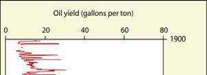
10 Methods 1) Compared Fischer assay data to density and sonic logs USGS - Coyote Wash 1
11 Methods 1) Compared Fischer assay data to density and sonic logs y = -85.5x R 2 2 = Oil Oil Yield from Fischer Assay (gpt) USGS - Coyote Wash Bulk Density (g/cm 3 3 ))
12 Methods 2) Created equation comparing bulk density to Fischer assays - Used 8 wells with R 2 ranging from 0.71 to Used a reduced major axes regression fit Oil Yield (gpt from Fischer A Reduced Major Axes Fit Relating Density and Shale Oil Yield y = x Bulk Density (g/cm 3 )
13 Methods 2) Created equation comparing sonic to Fischer assays - Used 4 wells with R 2 ranging from 0.64 to Used a reduced major axes regression fit Reduced Major Axes Fit Relating Sonic and Shale Oil Yield 90 Oil Yield from Fischer Assays (gpt) y = 0.766x Sonic (ft/sec)
 (ft) 2740 2740 2671 2671 Depth Depth (ft) (ft) 2760")

14 Methods - Ground truth verses calculated yield Shale Shale Oil Oil Yield Yield (gpt) (gpt) Depth Depth (ft) (ft) Depth Depth (ft) (ft) miles apart Average gpt of datasets: Gas well = 21.4 gpt U045 = 21.7 gpt Pseudo-FA from from density log log U045 U Oil Oil shale shale well well with with FA FA from from core core


15 Methods 3) Created pseudo-fischer assay logs from geophysical logs for wells throughout the Uinta Basin 100 wells using density 16 wells using sonic 52 wells with Fischer assays on core Landownership - BLM 40% - Private 28% - Tribal 22% - State 10%
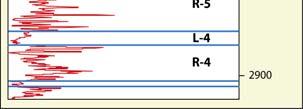
16 Methods 4) Calculated thickness of zones averaging 15, 25, 30, 35, 40, 45, and 50 gpt Average of 15 gpt 617 ft USGS - Coyote Wash 1
17 Methods 4) Calculated thickness of zones averaging 15, 25, 30, 35, 40, 45, and 50 gpt Average of 25 gpt 124 ft USGS - Coyote Wash 1


18 Methods 4) Calculated thickness of zones averaging 15, 25, 30, 35, 40, 45, and 50 gpt Average of 35 gpt 40 ft USGS - Coyote Wash 1

19 Results


20 Results

21 Results
22 Future Work 1) Create isopachs and structure contour maps of the different oil shale zones


23 Additional Work Depth to Various Zones Depth to Mahogany Bed

24 Additional Work Depth to Various Zones Depth to Mahogany Bed ft
25 Future Work 1) Create isopachs and structure contour maps of the different oil shale zones 2) Calculate resource numbers - Reserves according to different parameters - e.g. 15 gpt with a thickness of at least 15 feet - Reserves according to different recovery methods - surface mining - underground mining - in-situ
26 UGS Collaboration - Upper Green River Formation Projects 1) Dr. Royhan Gani Energy and Geoscience Institute University of Utah - Depositional heterogeneity and fluid flow modeling of the oil shale interval of the Green River Formation, eastern Uinta Basin, Utah - Detailed sedimentological and ichnological documentation of cores housed at the Utah Core Research Center - Facies descriptions - Fluid flow modeling 2) Dr. Jessica Whiteside Brown University - Multiproxy paleoclimate reconstruction of Earth s most recent extreme hothouse - Milankovitch cyclicity in the upper Green River Formation - High-resolution geochemistry from cores housed at the Utah Core Research Center 3) TerraTek, a Schlumberger Company, Salt Lake City, UT - Continuous unconfined compressive strength profiling (TSI scratch testing) and other physical property analyses of upper Green River oil shales
27 Underground mine: Back-of-the-envelope Assumptions: 40 ft of 35 gpt oil shale 5,000 acre lease 50% material recovery 90% shale oil extraction efficiency Results: 200 million bbls of oil 30,000 bbls per day for 20 years In-situ methods: Assumptions: 124 ft of 25 gpt oil shale 5,000 acre lease 60% shale oil extraction efficiency Results: 700 million bbls of oil 95,000 bbls per day for 20 years (2006 data) Utah crude oil production = 50,000 bbls per day Utah petroleum consumption = 145,000 bbls per day U.S. crude oil production = 5 million bbls per day U.S. petroleum consumption = 21 million bbls per day U.S. crude oil imports = 10 million bbls per day Utah s refinery capacity = 167,000 bbls per day Utah s refinery inputs = 151,000 bbls per day Utah s spare refinery capacity = 16,000 bbls per day

28 Hell s s Hole overlook at Evacuation Creek, Uinta Basin Mahogany bed
Basin-wide Evaluation of the Uppermost Green River Formation s s Oil-Shale Resource, Uinta Basin, Utah and Colorado
 Basin-wide Evaluation of the Uppermost Green River Formation s s Oil-Shale Resource, Uinta Basin, Utah and Colorado Michael D. Vanden Berg Utah Geological Survey November 13, 2008 Acknowledgements U.S.
REPORT OF INVESTIGATION NO. 37 UTAH GEOLOGICAL AND MINERALOGICAL SURVEY
 REPORT OF INVESTIGATION NO. 37 UTAH GEOLOGICAL AND MINERALOGICAL SURVEY DETERMINATION OF OIL.SHALE POTENTIAL GREEN RIVER FORMATION, UINTA BASIN NORTHEAST UTAH Prepared by Howard R..Ritzma Petroleum Geologist
Challenge of Mae Sot Oil Shale Exploration in Thailand (In the First Phase, 2008) Apichart Jeennagol Apiradee Suwannathong
 Apichart Jeennagol Apiradee Suwannathong") Challenge of Mae Sot Oil Shale Exploration in Thailand (In the First Phase, 2008) by Apichart Jeennagol Apiradee Suwannathong The 28 th Oil Shale Symposium October 15, 2008 Colorado School of Mines, Golden,
Challenge of Mae Sot Oil Shale Exploration in Thailand (In the First Phase, 2008) by Apichart Jeennagol Apiradee Suwannathong The 28 th Oil Shale Symposium October 15, 2008 Colorado School of Mines, Golden,
GREEN RIVER OIL SHALE POTENTIAL IN UTAH
 Paper 21 GREEN RIVER OIL SHALE POTENTIAL IN UTAH by M. Darwin Quigley 1 and Jack R. Price 2 The Green River formation of Colorado, Utah, and Wyoming contains the greatest potential reserves of oil in the
P.R. SPRING AND HILL CREEK TAR SAND AREAS A RESOURCE ASSESSMENT (IN PROGRESS)
") P.R. SPRING AND HILL CREEK TAR SAND AREAS A RESOURCE ASSESSMENT (IN PROGRESS) presented by WALLY GWYNN - Utah Geological Survey at the Western U.S. Oil Sands Technology Transfer Meeting February 22, 2008
P.R. SPRING AND HILL CREEK TAR SAND AREAS A RESOURCE ASSESSMENT (IN PROGRESS) presented by WALLY GWYNN - Utah Geological Survey at the Western U.S. Oil Sands Technology Transfer Meeting February 22, 2008
Update - Testing of the Strawn Sand, White Hat 20#3, Mustang Prospect, Permian Basin, Texas
 Date: 15 April 2019 ASX Code: WEL Directors John Kopcheff Non-Executive Chairman Neville Henry Managing Director Peter Allchurch Non-Executive Director Larry Liu Non-Executive Director Lloyd Flint Company
Addendum to November 2009 Vantage EA
 Addendum to November 2009 Vantage EA Introduction This document includes additional information, supplemental to that already provided within the Vantage Energy Uintah LLC Ashley National Forest Oil and
GIS-based Water Resource Geospatial Infrastructure for Oil Shale Development
 GIS-based Water Resource Geospatial Infrastructure for Oil Shale Development Wendy Zhou, Matthew Minnick, Mengistu Geza Colorado School of Mines, Golden, CO Kyle Murray University of Texas at San Antonio,
Testing of the Strawn Sand, White Hat 20#3, Mustang Prospect, Permian Basin, Texas
 Date: 11 April 2019 ASX Code: WEL Directors John Kopcheff Non-Executive Chairman Neville Henry Managing Director Peter Allchurch Non-Executive Director Larry Liu Non-Executive Director Lloyd Flint Company
OIL AND GAS PLAYS OF THE MICHIGAN BASIN, SOUTHERN ONTARIO. Terry Carter, Consulting Geologist London, Ontario
 OIL AND GAS PLAYS OF THE MICHIGAN BASIN, SOUTHERN ONTARIO Terry Carter, Consulting Geologist London, Ontario 1 Ontario Petroleum Industries Oil and Natural Gas 1250 oil wells, 1200 gas wells, annual production
Uncovering the greater McArthur Basin, Northern Territory Tania Dhu Manager Geophysics and Remote Sensing, Northern Territory Geological Survey
 Uncovering the greater McArthur Basin, Northern Territory Tania Dhu Manager Geophysics and Remote Sensing, Northern Territory Geological Survey www.minerals.nt.gov.au Why focus on the McArthur Basin? Large,
Climate History, Lake Evolution, and Predicting Organic Richness of the Green River Formation, Piceance Creek Basin, Colorado
 Climate History, Lake Evolution, and Predicting Organic Richness of the Green River Formation, Piceance Creek Basin, Colorado J. Frederick Sarg, Kati Tanavsuu-Milkeviciene, Jufang Feng, and Suriamin Huang
Dakota Sandstone. of the Moxa Arch and Surrounding Green River Basin
 Dakota Sandstone of the Moxa Arch and Surrounding Green River Basin Dakota Sandstones of the Green River Basin Overview The Dakota sandstones of the Moxa Arch and surrounding Green River Basin remain attractive
For personal use only
 Date: 18 February 2019 ASX Code: WEL Directors John Kopcheff Non-Executive Chairman Neville Henry Managing Director Peter Allchurch Non-Executive Director James Hodges Non-Executive Director Larry Liu
Oil Shale Resource in Mae Sot Basin, Thailand
 Oil Shale Resource in Mae Sot Basin, Thailand By Apiradee Suwannathong Department of Mineral Resources 27 th Oil Shale Symposium October 18, 2007 Colorado School of Mines Golden, Colorado 1 Outlines Distribution
MESOZOIC BASINS. North Carolina Geological Survey
 MESOZOIC BASINS North Carolina Geological Survey The 1823 organic act which created the North Carolina Geological Survey (NCGS) tasked us to examine, describe and map the geology, geologic hazards, and
Stephanie B. Gaswirth and Kristen R. Mara
 U.S. Geological Survey Assessment of Undiscovered Resources in the Bakken and Three Forks Formations, Williston Basin, North Dakota, Montana, and South Dakota, 2013 Stephanie B. Gaswirth and Kristen R.
The Green River and Wasatch formations in the Lake Uinta, and
 DCA ~280m Oil-stained Sandstone Consortium Proposal: Lacustrine Reservoirs from Deep to Shallow: Facies Distribution, Architecture, and Source Rock Formation Green River Formation, Utah & Colorado Microbial
MIDDLE DEVONIAN PLAY MICHIGAN BASIN OF ONTARIO. Duncan Hamilton
 MIDDLE DEVONIAN PLAY MICHIGAN BASIN OF ONTARIO Duncan Hamilton 1 Middle Devonian Pools of the Michigan Basin 375+ Million Barrels Michigan 45+ million Barrels Ontario 2 Outline of Presentation History
OVERVIEW OF THE ROGERSVILLE SHALE IN WEST VIRGINIA. Philip Dinterman West Virginia Geological & Economic Survey May 11, 2017
 OVERVIEW OF THE ROGERSVILLE SHALE IN WEST VIRGINIA Philip Dinterman West Virginia Geological & Economic Survey May 11, 2017 ACKNOWLEDGEMENT Dave Harris, John Hickman, Kentucky Geological Survey DATA NOTE
Grand Rapids Oil Sands 3D Seismic Incorporating and Comparing Multiple Data Types for Reservoir Characterization
 Grand Rapids Oil Sands 3D Seismic Incorporating and Comparing Multiple Data Types for Reservoir Characterization Laurie M. Weston Bellman* Oil Sands Imaging Inc., Calgary, Alberta laurie@oilsandsimaging.com
Source Sink Pipeline
 An Overview of Carbon Storage presented by Robert J. Finley Advanced Energy Technology Initiative Illinois State Geological Survey University of Illinois USA IEA Summer School Longyearbyen, Norway August,
Executive Summary Geologic Assessment of Undiscovered Oil and Gas Resources of the Eastern Great Basin Province, Nevada, Utah, Idaho, and Arizona
 Chapter 1 Executive Summary Geologic Assessment of Undiscovered Oil and Gas Resources of the Eastern Great Basin Province, Nevada, Utah, Idaho, and Arizona By U.S. Geological Survey Eastern Great Basin
BERG-HUGHES CENTER FOR PETROLEUM AND SEDIMENTARY SYSTEMS. Department of Geology and Geophysics College of Geosciences
 BERG-HUGHES CENTER FOR PETROLEUM AND SEDIMENTARY SYSTEMS Department of Geology and Geophysics College of Geosciences MISSION Integrate geoscience, engineering and other disciplines to collaborate with
Search and Discovery Article #10532 (2013)** Posted October 21, Abstract
** Posted October 21, Abstract") Utilizing the Delta Log R Method for Determining Total Organic Carbon of the Niobrara Formation, B Bench, Denver-Julesburg Basin, Colorado and Wyoming* Madeline K. Beitz 1, Robert Cunningham 2, and Lisa
Utilizing the Delta Log R Method for Determining Total Organic Carbon of the Niobrara Formation, B Bench, Denver-Julesburg Basin, Colorado and Wyoming* Madeline K. Beitz 1, Robert Cunningham 2, and Lisa
THE NEXT WAVE IN THE ILLINOIS BASIN
 THE NEXT WAVE IN THE ILLINOIS BASIN Themes Low Risk High Margins Opportunity through Joint Venture Ron Prefontaine ron@strata-x.com www.strata-x.com TSX.V: SXE ASX: SXA 2 Key Management with operations
Oil Shale Status and Prospects Presentation to Garfield County Energy Advisory Board October 1, 2009
 Oil Shale Status and Prospects Presentation to Garfield County Energy Advisory Board October 1, 2009 Dr. Jeremy Boak Center for Oil Shale Technology & Research Colorado School of Mines Outline General
Central North Dakota Shallow Gas Potential A Historical Perspective
 Central Shallow Gas Potential A Historical Perspective David W. Fischer Fischer Oil and Gas, Inc. Fred J. Anderson Department CURRENT ND ACTIVITIES ONLINE BIBLIOGRAPHY OF SHALLOW GAS REFERENCES ONLINE
The Shale Spectrum: Interdisciplinary understanding across oil shale, oil-bearing shale and gas shale plays
 The Center for Oil Shale Technology & Research & The Colorado School of Mines 31sᵗOil Shale Symposium October 17-21, 2011 at the Cecil H. & Ida Green Center, Colorado School of Mines, Golden, Colorado
Dawsonite breakdown reactions during pyrolysis in Green River Formation oil shale
 Dawsonite breakdown reactions during pyrolysis in Green River Formation oil shale Jeremy Boak, Colorado School of Mines Justin Birdwell, U. S. Geological Survey Outline Saline Minerals in Green River Formation
CARTER METALLURGICAL COAL PROJECT. Endurance Gold Corporation (EDG)
") CARTER METALLURGICAL COAL PROJECT McDOWELL COUNTY, WEST VIRGINIA Endurance Gold Corporation (EDG) Endurance Resources Inc. (ERI) Prepared by: Duncan McIvor, President and CEO Endurance Gold Corporation
CARTER METALLURGICAL COAL PROJECT McDOWELL COUNTY, WEST VIRGINIA Endurance Gold Corporation (EDG) Endurance Resources Inc. (ERI) Prepared by: Duncan McIvor, President and CEO Endurance Gold Corporation
Oil & Natural Gas Technology
 Oil & Natural Gas Technology DOE Award No.: DE-FE143 Topical Report CORE-BASED INTEGRATED SEDIMENTOLOGIC, STRATIGRAPHIC, AND GEOCHEMICAL ANALYSIS OF THE OIL SHALE BEARING GREEN RIVER FORMATION, UINTA BASIN,
Properties of Utah Tar Sands Threemile Canyon Area, P. R. Spring Deposit
 Report of Investigations 7923 Properties of Utah Tar Sands Threemile Canyon Area, P. R. Spring Deposit By L. C. Marchant, L. A. Johnson, and C. Q. Cupps Laramie Energy Research Center, Laramie, Wyo. UNITED
For personal use only
 Quarterly Activities Report Quarter Ending 30 September 2018 (ASX Code: HE8) (Helios or Company) is pleased to report its activities for the quarter ended 30 September 2018. Oil Discovery in the Ojinaga
Subsurface Maps. K. W. Weissenburger. Isopach. Isochore. Conoco, Inc. Ponca City, Oklahoma, U.S.A.
 Subsurface Maps K. W. Weissenburger Conoco, Inc. Ponca City, Oklahoma, U.S.A. INTRODUCTION Reservoir properties are mapped to promote optimal field development. Subsurface maps dictate well placement and
Short Course. Petroleum Geochemistry & Basin Evaluation. Available to EGI Corporate Associate Members. Overview. Objectives.
 Short Course Instructor: David Thul, M.Sc. Manager of Petroleum Geochemistry Petroleum Geochemistry & Basin Evaluation Available to EGI Corporate Associate Members Course Structure Lectures, presentation
Introduction Geology
 Introduction The Wild Horse Anticline is located in the prolific Bighorn Basin of Wyoming about 5 miles northeast of the town of Basin. This structure demonstrates excellent fourway closure encompassing
Yankee Ingenuity Will Capture the Prize
 The Elusive Bonanza Yankee Ingenuity Will Capture the Prize Chasing a Chasing a Mirage Decades of Quiet, Punctuated by Outbreaks of Hoopla and Hype An oil shale industry could be initiated by 2011 with
CHARACTERISTICS OF THE PR SPRING TAR SAND DEPOSIT UINTA BASIN, UTAH, USA. George F. Dana. Donna J. Sinks. Laramie Energy Technology Center
 CHARACTERISTICS OF THE PR SPRING TAR SAND DEPOSIT UINTA BASIN, UTAH, USA George F. Dana & Donna J. Sinks Laramie Energy Technology Center U. S. Department of Energy CONTENTS Abstract Introduction Geographic
I. INTRODUCTION 1.1. Background and Problem Statement
 I. INTRODUCTION 1.1. Background and Problem Statement The declining of global oil and gas reserves has encouraged the exploration campaign to both the frontier area and the revisit to the mature basins.
Search and Discovery Article #20097 (2011) Posted January 31, 2011
 Posted January 31, 2011") Integrated Geological and Engineering Studies in Support of Producing Light Oil from a Frozen Reservoir: A Case Study from Umiat Oil Field, Northern Alaska* C. Hanks 1, J. Mongrain 2, A. Dandekar 2, P.
Integrated Geological and Engineering Studies in Support of Producing Light Oil from a Frozen Reservoir: A Case Study from Umiat Oil Field, Northern Alaska* C. Hanks 1, J. Mongrain 2, A. Dandekar 2, P.
Water use estimate 2014 National Oil Shale Association March 2014 Background New information
 Water use estimate 2014 National Oil Shale Association March 2014 Oil shale developers have re-evaluated estimates of water usage. The National Oil Shale Association has analyzed the new data and produced
COLOR CLAIMS, INC. 637 S. 400 East, Cedar City, UT
 COLOR CLAIMS, INC. 637 S. 400 East, Cedar City, UT 84720 435-586-5072 435-590-5747 waynea1@yahoo.com Date: May 30, 2012 I, Craig Parkinson, Geologist, hereby state that the valuation report issued for
Evaluating Suitability of Appalachian Basin Reservoirs for NGLs Storage Jessica Moore, West Virginia Geological & Economic Survey
 1 THE APPALACHIAN STORAGE HUB STUDY: Evaluating Suitability of Appalachian Basin Reservoirs for NGLs Storage Jessica Moore, West Virginia Geological & Economic Survey 2 ASH STUDY OUR GOAL Complete a geologic
Barnett Shale-Woodford Shale play of the Delaware basin is it another giant shale gas field in Texas?
 Barnett Shale-Woodford Shale play of the Delaware basin is it another giant shale gas field in Texas? Bob Cluff The Discovery Group, Inc Denver, Colorado, USA bobcluff@discovery-group.com Delaware basin
Azimuthal Velocity Analysis of 3D Seismic for Fractures: Altoment-Bluebell Field
 Azimuthal Velocity Analysis of 3D Seismic for Fractures: Altoment-Bluebell Field Khaled Al Dulaijan and Gary F. Margrave CREWES Summary The 3D seismic data was acquired within Bluebell Field, the eastern
MITIGATE RISK, ENHANCE RECOVERY Seismically-Constrained Multivariate Analysis Optimizes Development, Increases EUR in Unconventional Plays
 White Paper MITIGATE RISK, ENHANCE RECOVERY Seismically-Constrained Multivariate Analysis Optimizes Development, Increases EUR in Unconventional Plays SM Seismically-Constrained Multivariate Analysis Optimizes
Best Practice Reservoir Characterization for the Alberta Oil Sands
 Best Practice Reservoir Characterization for the Alberta Oil Sands Jason A. McLennan and Clayton V. Deutsch Centre for Computational Geostatistics (CCG) Department of Civil and Environmental Engineering
New Mexico Geological Society
 New Mexico Geological Society Downloaded from: http://nmgs.nmt.edu/publications/guidebooks/32 Rio Blanco Oil Shale Company Tract C-a, Rio Blanco County, Colorado: Summary of geology and current development
East Gainsborough, Saskatchewan: a Prairie Evaporite salt dissolution and Mississippian erosional unconformity trap
 East Gainsborough, Saskatchewan: a Prairie Evaporite salt dissolution and Mississippian erosional unconformity trap Andre St.Onge* and Eric Strachan Upton Resources Inc., 3900, 205-5 th Avenue S.W., Calgary,
THE HISTORY AND PERFORMANCE OF VERTICAL WELL SOLUTION MINING OF NAHCOLITE (NaHCO 3 ) IN THE PICEANCE BASIN, NORTHWESTERN COLORADO, USA
 IN THE PICEANCE BASIN, NORTHWESTERN COLORADO, USA") Solution Mining Research Institute; Fall 2004 Technical Meeting Berlin, Germany THE HISTORY AND PERFORMANCE OF VERTICAL WELL SOLUTION MINING OF NAHCOLITE (NaHCO 3 ) IN THE PICEANCE BASIN, NORTHWESTERN
Solution Mining Research Institute; Fall 2004 Technical Meeting Berlin, Germany THE HISTORY AND PERFORMANCE OF VERTICAL WELL SOLUTION MINING OF NAHCOLITE (NaHCO 3 ) IN THE PICEANCE BASIN, NORTHWESTERN
THE NEW HARMONY GROUP (LOWER DEVONIAN)
") 2001. Proceedings of the Indiana Academy of Science 1 10:23-27 THE NEW HARMONY GROUP (LOWER DEVONIAN) REVISITED 1 John B. Droste and Alan S. Horowitz Department of Geological Sciences, Indiana : University,
2001. Proceedings of the Indiana Academy of Science 1 10:23-27 THE NEW HARMONY GROUP (LOWER DEVONIAN) REVISITED 1 John B. Droste and Alan S. Horowitz Department of Geological Sciences, Indiana : University,
RESERVOIR CATEGORIZATION OF TIGHT GAS SANDSTONES BY CORRELATING PETROPHYSICS WITH CORE-MEASURED CAPILLARY PRESSURE
 RESERVOIR CATEGORIZATION OF TIGHT GAS SANDSTONES BY CORRELATING PETROPHYSICS WITH CORE-MEASURED CAPILLARY PRESSURE Michael Holmes, Antony Holmes and Dominic Holmes, Digital Formation, Inc. Copyright 2004,
Thermal Basin Studies
 Thermal Basin Studies Temperature studies are an important tool in assessing maturation, hydrocarbon generation and geothermal potential In addition, sometimes they can be useful in determining over pressure
Geology and Natural Resources
 Geology and Natural Resources Brought to you by: Western Michigan University Department of Geosciences and The Michigan Geological Repository for Research and Education s K-12 Outreach Program Core Kids
JMRS11 Jan Mayen Ridge Sampling Survey 2011
 JMRS11 Jan Mayen Ridge Sampling Survey 2011 JMRS11 Report Presentation VBPR/TGS, February 2012 Confidentiality Screen dumps and the underlying data in this document are confidential and proprietary to
Follow this and additional works at: Part of the Geology Commons
 Western Michigan University ScholarWorks at WMU Michigan Geological Repository for Research and Education Geosciences 2016 Geology of Michigan William B. Harrison III Michigan Geological Repository for
Modeling Optimizes Asset Performance By Chad Baillie
 MARCH 2016 The Better Business Publication Serving the Exploration / Drilling / Production Industry Modeling Optimizes Asset Performance By Chad Baillie MISSOURI CITY, TX. As more well and completion data
2016 U.S. Geological Survey Assessment of Continuous Oil and Gas Resources in the Mancos Shale of the Piceance Basin
 2016 U.S. Geological Survey Assessment of Continuous Oil and Gas Resources in the Mancos Shale of the Piceance Basin U.S. Department of the Interior U.S. Geological Survey Uinta-Piceance Province Colorado
Education Days Moscow Opening Session
 Education Days Moscow 2013 Basin and Petroleum Systems Modelling: Applications for Conventional and Unconventional Petroleum Exploration Risk and Resource Assessments By Dr Bjorn Wygrala Schlumberger 21-22
FALCO PACIFIC COMPLETES INITIAL MODEL FOR THE HORNE 5 GOLD/SILVER/ZINC/COPPER DEPOSIT
 For Immediate Release NR 13-10 FALCO PACIFIC COMPLETES INITIAL MODEL FOR THE HORNE 5 GOLD/SILVER/ZINC/COPPER DEPOSIT (Vancouver, BC, September 16, 2013) Falco Pacific Resource Group Inc. ( Falco Pacific
Dr. Kenneth B. Taylor, P.G.
 North Carolina Forestry Association 2013 Annual Meeting October 3, 2013 Shale Gas 101: Natural Gas Exploration / Development: A North Carolina Perspective presented by Dr. Kenneth B. Taylor, P.G. State
Evaluating Geological Formations and Managing Ground-Water Resources: Can We Afford the Effort?
 Evaluating Geological Formations and Managing Ground-Water Resources: Can We Afford the Effort? Stanley T. Paxton & Todd Halihan Oklahoma State University GSA Annual Meeting Salt Lake City, Utah 16-19
Risk Assessment in the Quality Control of Oil Shale in Estonian Deposit. Sergei Sabanov
 DEPARTMENT OF MINING Risk Assessment in the Quality Control of Oil Shale in Estonian Deposit Sergei Sabanov 28th Oil Shale Symposium October 13-17, 2008 Presentation outline Introduction Mining technology
Saline Minerals in the Green River Formation, Green River and Washakie Basins, Wyoming
 Saline Minerals in the Green River Formation, Green River and Washakie Basins, Wyoming Glenn M. Mason Department of Geosciences, School of Natural Sciences, Indiana University Southeast, New Albany, Indiana
Detailed Sedimentology and Inorganic Geochemistry of the Dolgeville Formation and Utica Group of the Central Mohawk Valley, NY
 Detailed Sedimentology and Inorganic Geochemistry of the Dolgeville Formation and Utica Group of the Central Mohawk Valley, NY Daniel Miserendino Jeffrey T. Pietras Introduction and Purpose Drill cores
Oil and Gas Mineral Interest For Sale 2,145 acres in Cotton Valley/Hosston Sligo/Edwards Trend Exploration Trend
 Oil and Gas Mineral Interest For Sale 2,145 acres in Cotton Valley/Hosston Sligo/Edwards Trend Exploration Trend Milam County, Texas Fee Mineral interest is located in shallow oilfield discovered in 1940
Exploration, Drilling & Production
 Nontechnical Guide to PETMOLEUM Geology, Exploration, Drilling & Production Third Edition Norman J. Hyne, Ph.D. Contents Preface *i Introduction 1 The Nature of Gas and Oil 1 Petroleum 1 The Chemistry
Geosciences Career Pathways (Including Alternative Energy)
") Geosciences Career Pathways (Including Alternative Energy) Shale Carbonates Clastics Unconventionals Geology Characterization and Production Properties of Gas Shales Geomechanics in International Shale
Geosciences Career Pathways (Including Alternative Energy) Shale Carbonates Clastics Unconventionals Geology Characterization and Production Properties of Gas Shales Geomechanics in International Shale
LeBLANC JR., RUFUS, Exploration Technologies, Inc., Houston, TX ; VICTOR T. JONES, III, Exploration Technologies, Inc.
 LeBLANC JR., RUFUS, Exploration Technologies, Inc., Houston, TX ; VICTOR T. JONES, III, Exploration Technologies, Inc., Houston, TX How to Design an Exploration Surface Soil Gas Geochemical Survey: Illustrated
DENR s Oil and Gas Initiative. Legislative briefing March 7, 2011 by DENR s Geological Survey Program
 DENR s Oil and Gas Initiative Legislative briefing March 7, 2011 by DENR s Geological Survey Program South Dakota DOES have exploration for and production of oil and gas Taken from http://denr.sd.gov/des/og/producti.aspx
This material is part of the collection of the Philadelphia Water Department and was downloaded from the website Please contact the
 This material is part of the collection of the Philadelphia Water Department and was downloaded from the website www.phillyh2o.org Please contact the PhillyH2O webmaster for more information about this
Valley-Fill Sandstones in the Kootenai Formation on the Crow Indian Reservation, South-Central Montana
 DE-FG22-96BC14996--08 Valley-Fill Sandstones in the Kootenai Formation on the Crow Indian Reservation, South-Central Montana Quarterly Report April 1 - June 30, 1998 By David A. Lopez Work Performed Under
Modeling Lateral Accretion in the McMurray Formation at Grizzly Oil Sands Algar Lake SAGD Project
 Modeling Lateral Accretion in the McMurray Formation at Algar Lake SAGD Project Duncan Findlay 1, Thomas Nardin 1, Andrew Couch 2, Alex Wright 1 1 ULC, 2 EON Introduction Laterally accreting channel systems
COAU PROPERTY LEMHI COUNTY, IDAHO
 COAU PROPERTY LEMHI COUNTY, IDAHO Utah Mineral Resources 447 N 300 W, Suite 3 Kaysville, UT 84037 (801) 544-3421 ojgatten@nae-xploration.com Prepared by: North American Mine Services, LLC. March 21, 2017
Sequence Stratigraphy of the Upper Cretaceous Niobrara Formation, A Bench, Wattenberg Field, Denver Julesburg Basin, Colorado*
 Sequence Stratigraphy of the Upper Cretaceous Niobrara Formation, A Bench, Wattenberg Field, Denver Julesburg Basin, Colorado* Lisa E. Remington LaChance 1 and Mark C. Robinson 1 Search and Discovery Article
GEOLOGICAL JOHN C. FRYE, Chief URBANA
 STATE OF ILLINOIS WILLIAM G. STRATTON, Governor DEPARTMENT OF REGISTRATION AND EDUCATION VERA M. BINKS, Director STATE DIVISION OF THE GEOLOGICAL JOHN C. FRYE, Chief URBANA SURVEY ILLINOIS PETROLEUM 72
An Overview of the Tapia Canyon Field Static Geocellular Model and Simulation Study
 An Overview of the Tapia Canyon Field Static Geocellular Model and Simulation Study Prepared for Sefton Resources Inc. Jennifer Dunn, Chief Geologist Petrel Robertson Consulting Ltd. Outline Background
MAIDEN JORC RESOURCE CONFIRMS SIGNIFICANT COAL DEPOSIT AT MARIOLA COAL PROJECT, POLAND
 Level 1, 350 Hay Street, Subiaco, WA 6008 ABN 84 061 219 985 P: +61 8 6365 4519 F: +61 8 9388 6040 E:enquiries@balamara.com.au 15 October 2014 MAIDEN JORC RESOURCE CONFIRMS SIGNIFICANT COAL DEPOSIT AT
SOLUTION MINING OF NAHCOLITE AT THE AMERICAN SODA PROJECT, PICEANCE CREEK, COLORADO. M. Hardy Agapito Assocs., Inc. Grand Junction, CO
 Preprint 03-105 SOLUTION MINING OF NAHCOLITE AT THE AMERICAN SODA PROJECT, PICEANCE CREEK, COLORADO M. Hardy Agapito Assocs., Inc. Grand Junction, CO M. Ramey C. Yates K. Nielsen American Soda, LLP Parachute,
Oklahoma Geological Survey Oklahoma Coal Database ANALYTICAL HEADER TABLE DOCUMENTATION
 Oklahoma Geological Survey Oklahoma Coal Database ANALYTICAL HEADER TABLE DOCUMENTATION Point ID Data point identification number: the system is tied to location and is intended to provide a unique identifier
DISTRICTS, MINES, AND GEOCHEMISTRY DATABASES IN NEW MEXICO. Virginia T. McLemore and Maureen Wilks
 DISTRICTS, MINES, AND GEOCHEMISTRY DATABASES IN NEW MEXICO Virginia T. McLemore and Maureen Wilks ACKNOWLEDGEMENTS New Mexico Energy, Minerals and Natural Resource Department Company annual reports Personal
(Brown & Loucks, 2009)
") SECARB Phase 3, Task 15 Geological CO 2 Sequestration Capacity Estimate Offshore Northern Gulf of Mexico March 9, 2011 Prepared by David L. Carr Project Team: Cari Breton, GIS Analyst David L. Carr, Reservoir
SECARB Phase 3, Task 15 Geological CO 2 Sequestration Capacity Estimate Offshore Northern Gulf of Mexico March 9, 2011 Prepared by David L. Carr Project Team: Cari Breton, GIS Analyst David L. Carr, Reservoir
CENTRAL UTAH: A NEW OIL AND GAS PROVINCE
 CENTRAL UTAH: A NEW OIL AND GAS PROVINCE By Floyd and Mike By: Floyd Moulton and Mike Pinnell Wolverine Discovery Eastern Limit of Thrusting Presentation Outline Regional Setting Paleozoic Source Rock
OTC OTC PP. Abstract
 OTC OTC-19977-PP Using Modern Geophysical Technology to Explore for Bypassed Opportunities in the Gulf of Mexico R.A. Young/eSeis; W.G. Holt, G. Klefstad/ Fairways Offshore Exploration Copyright 2009,
Chapter GL GLOSSARY. in U.S. Geological Survey Digital Data Series 60. By T. R. Klett, James W. Schmoker, Ronald R. Charpentier, Thomas S.
 Chapter GL GLOSSARY By T. R. Klett, James W. Schmoker, Ronald R. Charpentier, Thomas S. Ahlbrandt, and Gregory F. Ulmishek in U.S. Geological Survey Digital Data Series 60 U.S. Geological Survey Selected
Reservoir Characterization of the Swan Hills Eastern Platform Trend; a Multi-disciplinary Approach in Building an Applied Model
 Reservoir Characterization of the Swan Hills Eastern Platform Trend; a Multi-disciplinary Approach in Building an Applied Model Thanos A. Natras*, Arcan Resources Ltd., Calgary, Alberta tnatras@arcanres.com
Oil Shale Project in Thailand
 Oil Shale Project in Thailand Progress of Oil Shale Exploration in Thailand (Phase 2) The cooperation of Thai agencies between Department of Mineral Fuels (DMF) and Electricity Generating Authority of
Gas over Bitumen in North Eastern Alberta
 Gas over Bitumen in North Eastern Alberta Was the Alberta Energy and Utility Board s blanket shut-in approach appropriate? Prepared by: Brad Wooley Student ID: 0327273 Professor: Joseph Doucette Class:
10. GEOTECHNICAL EXPLORATION PROGRAM
 Geotechnical site investigations should be conducted in multiple phases to obtain data for use during the planning and design of the tunnel system. Geotechnical investigations typically are performed in
Bog Hot Valley. (updated 2012)
") Bog Hot Valley (updated 2012) Geologic setting: Bog Hot Valley is located along a major fault lineament between Soldier Meadows Hot Springs and Oregon (figure; Hose and Taylor, 1974). This lineament can
Bog Hot Valley (updated 2012) Geologic setting: Bog Hot Valley is located along a major fault lineament between Soldier Meadows Hot Springs and Oregon (figure; Hose and Taylor, 1974). This lineament can
GEOLOGIC FINDINGS OF THE BENEDUM FOUNDATION S APPALACHIAN STORAGE HUB STUDY
 1 GEOLOGIC FINDINGS OF THE BENEDUM FOUNDATION S APPALACHIAN STORAGE HUB STUDY Kristin M. Carter, P.G., C.P.G. Assistant State Geologist Pennsylvania Geological Survey (Pittsburgh, PA) krcarter@pa.gov ACKNOWLEDGEMENTS
Experienced specialists providing consulting services worldwide. Coalbed Methane Consulting Services
 Experienced specialists providing consulting services worldwide Coalbed Methane Consulting Services Proven technical leadership Schlumberger is a world leader in coalbed methane (CBM) engineering and geosciences.
The Impact of Parasequence Stacking Patterns on Vertical Connectivity Between Wave-Dominated, Shallow Marine Parasequences, Book Cliffs, Eastern Utah
 The Impact of Parasequence Stacking Patterns on Vertical Connectivity Between Wave-Dominated, Shallow Marine Parasequences, Book Cliffs, Eastern Utah MALCOLM J. ARNOT and TIMOTHY R. GOOD* MALCOLM J. ARNOT
CO 2 storage capacity and injectivity analysis through the integrated reservoir modelling
 CO 2 storage capacity and injectivity analysis through the integrated reservoir modelling Dr. Liuqi Wang Geoscience Australia CO 2 Geological Storage and Technology Training School of CAGS Beijing, P.
Geoscience Information Network (US GIN)
") Geoscience Information Network (US GIN) 1,000 s of databases 1,000 s of collections 80,000+ geologic maps Distributed Web-based Interoperable Open source A different business model Traditional Lobby Congress
Geoscience Information Network (US GIN) 1,000 s of databases 1,000 s of collections 80,000+ geologic maps Distributed Web-based Interoperable Open source A different business model Traditional Lobby Congress
2003 GCSSEPM Foundation Ed Picou Fellowship Grant for Graduate Studies in the Earth Sciences Recipient
 2003 GCSSEPM Foundation Ed Picou Fellowship Grant for Graduate Studies in the Earth Sciences Recipient Tarek A. El Shayeb University of Texas at Austin Integrated reservoir characterization and 3-D diagenetic
SOUTHWEST & NORTHWEST EXPLORATION PROJECTS BINGHAM CANYON MINING DISTRICT
 SOUTHWEST & NORTHWEST EXPLORATION PROJECTS BINGHAM CANYON MINING DISTRICT SALT LAKE AND TOOELE COUNTIES, UTAH SUMMARY FRIDAY, MARCH 20, 2009 1 Tooele County Salt Lake County GOOGLE EARTH September, 2006
Subsurface Mapping 1 TYPES OF SUBSURFACE MAPS:- 1.1 Structural Maps and Sections: -
 Subsurface Mapping The purpose of subsurface mapping in the geology of petroleum Is to find traps that contain oil and gas pools and the information obtained from wells forms the heart of the data upon
For personal use only
 ASX ANNOUNCEMENT 31 July 2018 For personal use only ASX: ASN, ASNOB Anson Application to Drill for Lithium Brine Approved Highlights: Notice of Intent (NOI) to drill Long Canyon A1 site approved by BLM