State-of-the-art equipment in all geophysical methods > 10 permanent employees
|
|
|
- Alexandra Young
- 5 years ago
- Views:
Transcription


1 -

 Established in 2002, Geo2X SA has an acquired specialization in applied geophysics. Our activities were firstly aimed at local surveying, which quickly evolved into vibroseis prospection.")
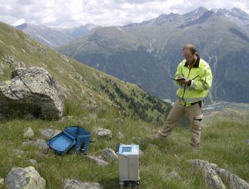
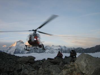
2 State-of-the-art equipment in all geophysical methods > 10 permanent employees > 100 available and flexible collaborators for large projects Worldwide experience Strong research and development of hardware and software 2002 Geo2X Sàrl foundation in Geneva by J. Jenny & J.-M. Frautschi 2006 Relocation to Lausanne (VD) 2012 Status change to SA 2014 AGAP and ISO 9001 certifications 2015 ISO and OHSAS18001 certifications 2016 Opening of Swissgerman Geo2X branch in Baar (ZG) Established in 2002, Geo2X SA has an acquired specialization in applied geophysics. Our activities were firstly aimed at local surveying, which quickly evolved into vibroseis prospection. Since 2012, our focus has been geotechnical identification through joint geophysical methods. Our global experience is key to find specific solutions for varied issues (hydrogeology, natural resources, landslides, pollution, etc.) in many environments. A particular effort is put into research and development of new hardware and software, allowing us to have innovative answers to complex situations. Our team holds 12 geophysicists, geologists and engineers. When considering large projects, our team can hold up to 120 members. Client demands are met with quality through exceptional mastery in key software (geophysics and cartography). Our complete range of equipment meets the highest accurate standards for each geophysical technique.
.")
3 Applied geophysics is a field of Earth Sciences that uses quantitative methods derived from physics to identify buried geological or anthropological structures. The primary contribution of geophysics is its capacity to provide information on the distribution of given parameters in the ground (seismic velocity, electrical resistivity, etc.). Geophysical methods allow us to create precise geological models at an optimized cost through regionalization of borehole data. - Geological interpretation of a site is constrained through the use of multiple and joint geophysical techniques. The selected technique d e p e n d s o n t h e matter and structure to investigate. T h i s m u l t i - m e t h o d approach grants the optimization of borehole locations, therefore reducing costs. Reflection seismology Geothermal exploration Reservoirs Stratigraphy, structural Faulting Refraction / MASW Geological structures Landslides Geotechnical parameters Logs Geotechnics Stratigraphy Electric tomography Aquifers / Porosity Quaternary stratigraphy Geological structures Gravity exploration Void detection Faulting / alteration Geothermal reservoirs EM - Magnetic exploration Buried waste Archaeology Buried service networks Georadar Void detection Archaeology Buried service networks


 allow us to meet all requirements for any")
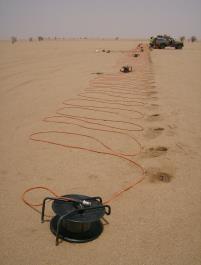
4 Geological structures Stratigraphy Faulting Geothermal explorations Hydrogeology Mining prospection Reservoirs Reflection seismology is based on the analysis of wave reflection caused by geological boundaries. These are observed when a difference in densities and/or seismic velocities occur between two domains. The ability to illustrate contrasts in density and/or velocity makes reflection seismology an optimal technique for geological cross-section creation and stratigraphic analysis. The presence of gaps in underground reflectors is useful to identify faults and tectonic features. Sensitive to ambient seismic noise Source selection linked to objective Low imaging capacity for the first decameters Our wide range of equipment (sources and receivers) allow us to meet all requirements for any investigation. Optimized acquisition procedures allow us to guarantee quality imaging for various environments.
 for specific requirements in each")

, this technique has become")

5 In addition to pulse sources, vibrating sources are often used for seismic exploration. These sources transmit adequate signals (frequencies, duration) for specific requirements in each study. Oil and gas prospecting Deep geothermal energy Fault detection, paraseismic Stratigraphy Structural geology Vibroseis exploration techniques were designed for petroleum prospecting. Because of its proficiency at great depths (several kilometers), this technique has become essential for geothermal exploration. This is an unmatched technique for stratigraphy and fault recognition. Heavy equipment Permitting Vibration monitoring, infrastructure protection Our cutting-edge acquisition procedures, equipment and data processing allow us to provide very high resolution shallow seismic images.


6 Geological structures Landslides Geotechnical parameter distribution Alteration / Faulting Source selection depends on ambient noise and measurement device Sensitive to wind and movement In geological framework, it is possible to discriminate lithologies using their seismic velocities (V P and V S ). These values are obtained through seismic refraction and surface waves data processing (MASW). Ambient noise affects the selection of seismic sources. When correctly adapted, seismic refraction cross-sections are of great quality. Our seismic sources are capable of giving us accurate data for any type of surroundings. Sledgehammer Seismic gun Weight drop Explosives Acquisition procedures for both techniques are similar. Joint analysis of seismic refraction and MASW notably eases geological interpretation. Simultaneous use of both methods allows us to calculate some of the major geotechnical parameters. MASW analysis results are handled to characterize terrains for paraseismic engineering by calculating the VS 30 value. This European classification is used in most field recognitions for heavy infrastructure establishment.


 Poisson s ratio (V P and V S ) Young s modulus (V P, V S and density) Bulk")
.")
7 Geotechnics and geophysics are complementary domains. Geophysical results are ideal to regionalize geotechnically calibrated data. Mechanical moduli are calculated through the juncture of seismic, gravity and borehole data. These are used in civil engineering structure gauging, geotechnical anomaly detection, and borehole campaign optimization. Shear modulus (V S and density) Poisson s ratio (V P and V S ) Young s modulus (V P, V S and density) Bulk modulus (V P, V S and density) V P & V S Density Resistivity / Conductivity Natural radioactivity Imaging Borehole measurements gather borehole logging and well geophysics (downhole, uphole, crosshole). This allow us to characterize multiple parameters of spanned terrains (velocities, densities, resistivities, radioactivity, faulting, etc.). These measurements are ideal proxies to calibrate results from shallow geophysical techniques.


8 Hydrogeology Gravel pit Landslides Geological structures Mining prospection Foundations The electrical resistivity of a geological layer changes with its composition, porosity and saturation. Measurement procedures for resistivity depends on the type of investigation. Vertical surveys or profiles are the usual outputs of electrical techniques. Our hardware and software allow us to choose from all acquisition geometries and adapt them to different issues. Depth penetration depends on conductivity Buried service networks Metallic structures Cross-sections acquired through electrical tomography can be implemented in numerous contexts. Among the main uses, there are: Aquifer detection Natural resource gauging Mineralization (IP) Innovative techniques allow measurement and output of 3D data, e.g. foundation investigations.


9 Gravity exploration measures variations in gravity, which depends on density contrasts amongst geological or anthropological objects. The instruments we possess are extremely sensitive, allowing us to identify small-scale objects (microgravity) or define geological structure geometries on a larger scale. Gravity surveys are performed as profiles or maps. For example, road or railway constructions require potential void detection along profile lines. Other inquiries, such as large infrastructure construction, call for a cartographic output of gravimetric anomalies. Underlying geology can be modeled using both types of measurements. Void detection Karst detection Alteration, faulting Buried structures Archaeology Density calculations Geological structures Deep geothermal energy Numerical field model Levelling (microgravity) Meteorological conditions Specific approaches in gravity exploration are able to precisely quantify mean densities of quaternary formations. This is the first step for stratigraphic reconstruction of sedimentary basins.


10 - - Buried waste Networks and structures Archaeology Magnetic and electromagnetic exploration techniques are of choice for buried object detection, especially if anthropological. These lightweight and fast methods are optimal for detailed recognition of contaminated sites. Our state-of-the-art equipment is able to provide images of the first few underlying meters. - Depth penetration depends on conductivity Buried networks, pylons, metallic structures - Shallow geological structures Buried networks and structures Archaeology - Shallow penetration in high conductivity environments Metallic structures Georadar (Ground Penetrating Radar or GPR) is perfectly adapted for exploration and characterization of buried structures or voids and provides high resolution images on the first few underlying meters or decimeters. Radar antenna frequencies and type of survey (profile or 3D block) are chosen from study specifics. Our wide range of equipment allows us to respond to varied requests, especially in archaeology or civil engineering.
 is routinely updated to assess the most recent technological progress.")


11 Quality geophysical results demand extreme precision in terms of positioning. In order to ensure this precision, our equipment (differential GPS, total station, automatic level) is routinely updated to assess the most recent technological progress. We also offer specialized services, such as photogrammetry and LiDAR. Our equipment is adjusted based on the surroundings and required precision of each study. Our experienced surveying teams allow an appropriate response to all types of terrains and surveys: Line and point stake-out; Line clearance; Point, profile and levelling surveys. Surveying datasets are analyzed, verified and mapped in leading software: Trimble Business Center; ArcGIS. Graphic and numeric outputs are adapted to meet each of our clients requests. Reflection seismology XYZ - 10 centimeters Refraction seismology XYZ - 10 centimeters ERT XYZ - 10 centimeters Gravity XY - 10cm Z - max 0.5cm EM - Magnetism XYZ - 10 centimeters Georadar XYZ - 5 centimeters Bathymetry XYZ - 5 centimeters Inertial measurement unit Tide gauge


12 Bathymetry Alpine lake sedimentation monitoring Very high resolution and precision seafloor cartography Geo2X not only offers services in terrestrial geophysics, we also provide the following: Multi-beam bathymetry; Side-scan sonar, sub-bottom profiler; Lacustrine and marine reflection seismology. Profiler & Sonar Alpine lake stratigraphy and sediment characterization Very high resolution for shallow water imaging Bathymetry measurements produce centrimetric seafloor recognitions. This allows us to assist our clients in numerous situations, some of which are the following: Structure and work installation, pipelines, navigation security; Volume calculation, dredging monitoring, hydroelectric dam draining efficiency. Reflection seismology has the ability to detect interfaces between sediment and/or rock layers beneath the seafloor. This allows geological identification, sediment thickness determination, and stratigraphic studies. Reflection seismology Geological structures Sediment-rock contact Faulting
.")


 and Leeds (UK).")


13 Continuous research on cutting-edge solutions to complex issues has encouraged us to develop the following research focuses: Participation in the NeTTUN project (European commission). Geological characterization during TBM progression through V S and GPR seismic imaging; Very high resolution shallow water acquisition and data processing through reflection seismology; Characterization of deep geothermal reservoirs through innovative 3D gravity techniques; Gravity method applications aiming on precise quantification of quaternary formation densities. As part of these projects, close collaborations have been established with the Universities of Lausanne, Geneva, Neuchâtel, EPFL, ETH, Delft (NL) and Leeds (UK). Thanks to the extensive amount of data generated on our projects, our expertise and the specific requests from each of our clients, we have developed software encompassing most of the geophysical techniques: Seismic data processing (reflection and refraction); Electromagnetic data acquisition; Electrical surveying; Vibration monitoring, infrastructure protection. These products are continuously updated to assess the latest research progress.

; Technical aid, assistance in choosing adequate geophysical methods for individual situations, geological interpretation assistance.")

14 Processing/Reprocessing Acquisition supervision for all techniques Tender Technical aid Seismic data acquisition and processing (reflection and refraction) Electrical data acquisition and processing Gravity exploration data acquisition and processing Borehole data acquisition and processing Our team s noteworthy knowledge in all geophysical techniques allows us to provide services of expertise and consulting in the following areas: Processing, reprocessing of raw data, data processing supervision; Tender (writing and analysis); On site supervision for all onshore/offshore geophysical techniques (client representative); Technical aid, assistance in choosing adequate geophysical methods for individual situations, geological interpretation assistance. Our engineers at Geo2X are at your service for training in applied geophysics, sharing their years of worldwide acquired experience. This training primarily addresses geologists or geotechnicians eager to grasp the basics of geophysics, data acquisition and result interpretation. Training is adjusted as required to meet the specific needs of each of our clients and can be coordinated anywhere in the world. Adequate and routinely updated course material is available during sessions.


15 In order to guarantee proper management and services, Geo2X has received the ISO 9001 certification in December This certification is the basis of continuous internal improvement within our company. Client satisfaction follow-up has also been established. Since 2015, the ISO and OHSAS certifications have become an integral part of our work procedures. These certifications set standards regarding environmental management, health, and security during our practices. We have also received quality certifications issued by the Association pour la qualité en géophysique appliquée (AGAP, France). Regardless of the location and objective of our practices, we apply strict security criteria for our employees, third parties, infrastructures and the environment. We commit to the following: Do not harm anyone; Protect the environment; Efficiently use resources and energy that our practices require; Transparent communication; Consider local customs; Promote the commitment of all to respect and follow our policy; Promote these engagements to our subcontractors. By strictly respecting these engagements, we create trusting affiliations with all our partners, clients, employees and third parties. ISO 9001:2015 ISO 14001:2015 OHSAS 18001:2007 AGAP Qualité


16 Geo2X SA Rue du Centre 6 CH-1377 Oulens-sous-Echallens ISO 9001, 14001, OHSAS AGAP Qualité Geo2X AG Baar Mühlegasse 18M CH-6340 Baar Phone: info@geo2x.com Phone: baar@geo2x.com
Geophysical, Geological and Environmental Services
 Geophysical, Geological and Environmental Services Experience KAZAKHSTAN MOLDOVA CROATIA SERBIA ROMANIA MONTENEGRO BULGARIA F.Y.R.O.M. ALBANIA ARMENIA PORTUGAL GREECE TURKEY SYRIA IRAN AFGHANISTAN MOROCCO
High Resolution Geophysics: A Better View of the Subsurface. By John Jansen, P.G., Ph.D., Aquifer Science and Technology
 High Resolution Geophysics: A Better View of the Subsurface By John Jansen, P.G., Ph.D., Aquifer Science and Technology Geologist Use Only Part of the Information Available To Them Most Geologist rely
Geophysics for Environmental and Geotechnical Applications
 Geophysics for Environmental and Geotechnical Applications Dr. Katherine Grote University of Wisconsin Eau Claire Why Use Geophysics? Improve the quality of site characterization (higher resolution and
Geophysics for Land Development
 Geophysics for Land Development About Us Whatever your area of interest GBGMAPS can provide advanced subsurface and structural geophysical solutions to add value to your product. Mining and infrastructure
Discovering the Earth s Resources. Geophysical, Geological and Environmental Services
 Geophysical, Geological and Environmental Services Services Overview Prospectiuni SA is the leading geophysical and geological service company in South Eastern Europe with 60 years of experience of international
FUNDAMENTALS OF ENGINEERING GEOLOGY
 FUNDAMENTALS OF ENGINEERING GEOLOGY Prof. Dr. HUSSEIN HAMEED KARIM Building and Construction Engineering Department 2012 Preface The impulse to write this book stemmed from a course of geology given by
Petroleum Exploration
 Petroleum Exploration Upstream Petroleum Exploration The role of exploration is to provide the information required to exploit the best opportunities presented in the choice of areas, and to manage research
An Introduction to Applied and Environmental Geophysics
 An to Applied and Environmental Geophysics 2nd Edition John M. Reynolds Reynolds International Ltd Preface to the 2 na Edition Acknowledgements 1 1.1 1.2 1.3 1.4 1.5 What are 'applied' and 'environmental'
Geotechnical Engineering and Dams
 Geotechnical Engineering and Dams Solving Geotechnical Challenges for Hydropower and Water Resources Projects Geological and geotechnical challenges are often very demanding when planning hydraulic structures.
Applied Geophysics for Environmental Site Characterization and Remediation
 Applied Geophysics for Environmental Site Characterization and Remediation MSECA Webinar September 24, 2015 John Mundell, P.E., L.P.G. Ryan Brumbaugh, L.P.G. MUNDELL & ASSOCIATES, INC. Webinar Objective
Geophysical Site Surveys
 Geophysical Site Surveys Simon Oakley Geoscience Team Leader Fugro Survey Limited 16/04/2014 Contents Menu Introduction Section 1 - Geophysical Site Surveys - Seabed Bathymetry - Shallow Geology - Seabed
ambiguity in earth sciences IESO Geophysics Section Eddy hartantyo, Lab Geofisika FMIPA UGM
 ambiguity in earth sciences IESO Geophysics Section Eddy hartantyo, Lab Geofisika FMIPA UGM Pelatihan Tahap II IESO Teknik Geologi UGM Februari 2009 1 Introduction Photos from http://www.eegs.org/whatis/
Patterns in Geophysical Data and Models
 Patterns in Geophysical Data and Models Jens Tronicke Angewandte Geophysik Institut für Geowissenschaften Universität Potsdam jens@geo.uni-potsdam.de Near-surface geophysics Using geophysical tools to
Geophysics. Geotechnics. Geophysics. Earthworks. Environment. Groundwater. Rock Mechanics. Integrated Practical Solutions
 Geophysics Geotechnics Environment Groundwater Rock Mechanics Geophysics Earthworks Integrated Practical Solutions Geophysics Services Our 50 years of experience gained over 100,000 completed projects,
Innovation in the marble industry Javier Fernández Cortés Managing Director
 Entrepreneurial Discovery Focus Group on Non Metallic Minerals in Eastern Macedonia and Thrace 5 May 2015 Drama, Greece Innovation in the marble industry Javier Fernández Cortés Managing Director 1 Who
Global Geophysical. Geophysical Service Solutions
 Geophysical Service Solutions is a geophysical consultancy firm specializing in providing geophysical solutions to appropriate mining, environmental and engineering problems. Site-appropriate geophysical
THE 4Gs IN PRACTICE: INVESTIGATING HOW THE 4Gs ARE APPLIED IN THE OIL & GAS INDUSTRY
 THE 4Gs IN PRACTICE: INVESTIGATING HOW THE 4Gs ARE APPLIED IN THE OIL & GAS INDUSTRY Society for Underwater Technology, Evening Technical Meeting 14 AUGUST 2013 GEOPHYSICS & PORT DEVELOPMENTS EXPLORING
Major Points in Introduction
 Near- Surface Processes and Resources John Louie - louie@seismo.unr.edu eismo. unr.edu Thomas Pratt tpratt@ocean.washington.edu ashington.edu Here is a Laundry List- With it, we can prioritize Major Points
Advancing Geoscientific Capability. Geological Survey of Finland
 Advancing Geoscientific Capability Geological Survey of Finland GTK in brief The Geological Survey of Finland (GTK) is one of the largest European centres of excellence in assessment, research and the
Does the SDCP need inputs from geology?
 The British Geological Survey s Experience and Expertise in Supporting Projects such as the Sirte Depression Connection Project David Ovadia Director of International Kingsley Dunham Centre Keyworth Nottingham
National Geophysical Survey Science Opportunities
 National Geophysical Survey Science Opportunities Anton Ziolkowski Professor of Petroleum Geoscience University of Edinburgh BGS Keyworth 4 April 2016 Outline Brief biography Science opportunities High
Marine Heat Flow Measurements Information Brochure
 Marine Heat Flow Measurements Information Brochure 5 1 2 3 4 5 5 6 7 8 5 9 10 11 12 13 14 5 15 16 17 18 19 20 21 5 22 0 200 400 600 800 1000 1200 1400 1600 Time (s) What is the use of heat flow measurements?
LOZAR RADAR INTRODUCTORY PRESENTATION COAL SURVEYING
 LOZAR RADAR INTRODUCTORY PRESENTATION COAL SURVEYING WWW.LOZARRADAR.COM ABOUT LOZAR RADAR Lozar Radar is a ground-scanning device, which verifies and investigates the presence of mineral resources and
Seismic Interpretation & Exploration
 Seismic Interpretation & Exploration Ecolog is a private consulting and design firm established in 2002, with a track record of designing, managing and executing exploration activities and geophysical-geological
Technical Drafting, Geographic Information Systems and Computer- Based Cartography
 Technical Drafting, Geographic Information Systems and Computer- Based Cartography Project-Specific and Regional Resource Mapping Services Geographic Information Systems - Spatial Analysis Terrestrial
MSCL-S: MULTI-SENSOR CORE LOGGER NON-DESTRUCTIVE CONTINUOUS CORE SCANNING FOR INDUSTRY & RESEARCH
 MSCL-S: MULTI-SENSOR CORE LOGGER NON-DESTRUCTIVE CONTINUOUS CORE SCANNING FOR INDUSTRY & RESEARCH IF CORE S WORTH TAKING, IT S WORTH LOGGING AUTOMATED & FLEXIBLE CORE LOGGING & SCANNING The Geotek Standard
PETROLEUM GEOSCIENCES GEOLOGY OR GEOPHYSICS MAJOR
 PETROLEUM GEOSCIENCES GEOLOGY OR GEOPHYSICS MAJOR APPLIED GRADUATE STUDIES Geology Geophysics GEO1 Introduction to the petroleum geosciences GEO2 Seismic methods GEO3 Multi-scale geological analysis GEO4
We N Geophysical Near-surface Characterization for Static Corrections: Multi-physics Survey in Reggane Field, Algeria
 We N114 01 Geophysical Near-surface Characterization for Static Corrections: Multi-physics Survey in Reggane Field, Algeria A. Pineda* (Repsol), S. Gallo (CGG) & H. Harkas (GRN Sonatrach) SUMMARY We are
Geophysical exploration methods at European sites
 Geophysical exploration methods at European sites David Bruhn, GFZ Potsdam, Section 5.2 Geothermics, 14473 Potsdam, Germany Most geophysical exploration methods have been developed for the oil and gas
Lesson 1 Introduction to geophysical methods Emanuele Forte
 Lesson 1 Introduction to geophysical methods Emanuele Forte 3 rd September 2016 Naxos, Greece 1 Outline - What is Geophysics - Base concepts: (Geo)Physical parameters Sensitivity Resolution - Active and
Harvey Thorleifson, Director, Minnesota Geological Survey. Status of geological mapping needed for groundwater protection in Minnesota
 Harvey Thorleifson, Director, Minnesota Geological Survey Status of geological mapping needed for groundwater protection in Minnesota Minnesota is located between the Dakotas and Wisconsin, north of Iowa,
Landslide Mapping and Hazard Analysis for a Natural Gas Pipeline Project
 CIVIL GOVERNMENT SERVICES MINING & METALS OIL, GAS & CHEMICALS POWER Albert Kottke, Mark Lee, & Matthew Waterman Landslide Mapping and Hazard Analysis for a Natural Gas Pipeline Project Technical Innovation
Our Services. What We Do. How We Can Help. Contact us today: January (0)
") Listening and Understanding to Optimize our Efficiency Our Experience and Knowledge to Work for You Tailor-made Solutions to Meet your Needs Our Challenge is You Success What We Do Our Services GeoViz
Listening and Understanding to Optimize our Efficiency Our Experience and Knowledge to Work for You Tailor-made Solutions to Meet your Needs Our Challenge is You Success What We Do Our Services GeoViz
Geophysical Site Investigation (Seismic methods) Amit Prashant Indian Institute of Technology Gandhinagar
 Amit Prashant Indian Institute of Technology Gandhinagar") Geophysical Site Investigation (Seismic methods) Amit Prashant Indian Institute of Technology Gandhinagar Short Course on Geotechnical Aspects of Earthquake Engineering 04 08 March, 2013 Seismic Waves
Geophysical Site Investigation (Seismic methods) Amit Prashant Indian Institute of Technology Gandhinagar Short Course on Geotechnical Aspects of Earthquake Engineering 04 08 March, 2013 Seismic Waves
The fields of application of the Ground Penetrating Radar (GPR) are: CONSTRUCTION APPLICATIONS
 are: CONSTRUCTION APPLICATIONS") I.Industrial (technical) applications of geophysical methods used by the Archeo-geophysics laboratory in construction, plumbing, geotechnical engineering, engineering geology, mining, electricity power
I.Industrial (technical) applications of geophysical methods used by the Archeo-geophysics laboratory in construction, plumbing, geotechnical engineering, engineering geology, mining, electricity power
MT Prospecting. Map Resistivity. Determine Formations. Determine Structure. Targeted Drilling
 MT Prospecting Map Resistivity Determine Formations Determine Structure Targeted Drilling Cross-sectional interpretation before and after an MT survey of a mineral exploration prospect containing volcanic
Geological Mapping using Geophysics
 Geological Mapping using Geophysics Pugin, A.J.M. and T.H. Larson Illinois State Geological Survey, 615 E Peabody Dr., Champaign, IL 61820; E-mail: A.J.M. Pugin at pugin@isgs.uiuc.edu Mapping Techniques.
FIRE DEPARMENT SANTA CLARA COUNTY
 DEFINITION FIRE DEPARMENT SANTA CLARA COUNTY GEOGRAPHIC INFORMATION SYSTEM (GIS) ANALYST Under the direction of the Information Technology Officer, the GIS Analyst provides geo-spatial strategic planning,
indigeo Consultants Pvt Ltd Geophysical Surveys Geological Surveys GIS & Data Solutions Image Processing indigeo Company Profile, Page 1
 indigeo Consultants Pvt Ltd Geophysical Surveys Geological Surveys GIS & Data Solutions Image Processing MM Corner, 3 rd Floor #58, Banaswadi Main Road Bangalore 560033 INDIA Ph: +91 80 41638310 Mob: +91
Independent Commission for Mines and Minerals, Kosova Rr. Armend Daci Nr.1 Prishtinë prishtn, Kosovo
 Journal of Materials Science and Engineering A 5 (7-8) (2015) 269-273 doi: 10.17265/2161-6213/2015.7-8.003 D DAVID PUBLISHING Mr.sc Xhevdet Kastrati * and Mr Sc. Ramiz Krasniqi Independent Commission for
Terranum Sàrl. Rock-solid Expertise and Software
 Terranum Sàrl Rock-solid Expertise and Software About Founded in May 2011, Terranum Sàrl develops rock-solid expertise for natural hazards, geology, hydrology, 3D and LiDAR measurements, and customized
Site Characterization & Hydrogeophysics
 Site Characterization & Hydrogeophysics (Source: Matthew Becker, California State University) Site Characterization Definition: quantitative description of the hydraulic, geologic, and chemical properties
BCGQ Mission Statement. Acquire new geoscientific knowledge in Québec within a sustainable development perspective of our mineral resources.
 BCGQ Mission Statement Acquire new geoscientific knowledge in Québec within a sustainable development perspective of our mineral resources. Financial Resources Natural Resources Fund, Mining Heritage Section
Seismoelectric Ground-flow DC-4500 Locator
 Seismoelectric Ground-flow DC-4500 Locator Introduction The seismoelectric survey is a new technology combined the electro kinetic potential method and geophysical technology. It is applied directly to
Geophysics the use of geology, laboratory & field experiments, mathematics, and instruments to study: Earthquakes and Volcanoes seismometers,
 Geophysics the use of geology, laboratory & field experiments, mathematics, and instruments to study: Earthquakes and Volcanoes seismometers, tiltmeters, EDM, remote sensing, Energy: oil, gas, hydrothermal
Land Administration and Cadastre
 Geomatics play a major role in hydropower, land and water resources and other infrastructure projects. Lahmeyer International s (LI) worldwide projects require a wide range of approaches to the integration
Geophysical Exploration in Water Resources Assessment. John Mundell, P.E., L.P.G., P.G. Ryan Brumbaugh, L.P.G. Mundell & Associates, Inc.
 Geophysical Exploration in Water Resources Assessment John Mundell, P.E., L.P.G., P.G. Ryan Brumbaugh, L.P.G. Mundell & Associates, Inc. Presentation Objective Introduce the use of geophysical survey methods
ITASCA Consulting Canada Inc.
 Forward Thinking Engineering World leaders in geomechanics, hydrogeology and microseismicity. Solving problems for clients in the mining industry. Itasca offers advanced, first-hand knowledge of mining
Application of Ground Penetrating Radar for hydro-geological study
 Journal of Scientific & Industrial Research Vol. 65, February 2006, pp. 160-164 Application of Ground Penetrating Radar for hydro-geological study K K K Singh* Central Mining Research Institute, Dhanbad
Common Exploration Methods.
 Common Exploration Methods. The following list contains the most common methods which a company with a mineral prospecting licence in Northern Ireland might use to carry out a mineral prospecting programme.
GEOMATICS. Shaping our world. A company of
 GEOMATICS Shaping our world A company of OUR EXPERTISE Geomatics Geomatics plays a mayor role in hydropower, land and water resources, urban development, transport & mobility, renewable energy, and infrastructure
6162 Upper Rhine Graben: 3D Seismic - A New Approach to Geothermal Exploration in a Structurally Complex Tectonic Enviroment
 6162 Upper Rhine Graben: 3D Seismic - A New Approach to Geothermal Exploration in a Structurally Complex Tectonic Enviroment C. G. Eichkitz* (Joanneum Research), M.G. Schreilechner (Joanneum Research),
The Afar Rift Consortium
 The Afar Rift Consortium University of Bristol University of Oxford University of Cambridge British Geological Survey University of Rochester University of Auckland, NZ Opportunistic programme following
An Introduction to Geophysical Exploration
 An Introduction to Geophysical Exploration Philip Kearey Department of Earth Sciences University of Bristol Michael Brooks Ty Newydd, City Near Cowbridge Vale of Glamorgan Ian Hill Department of Geology
Summary. Introduction. Theory and/or Method
 Case studies from Fort Mc Murray, Horn River basin and Manitoba displaying advances in technology, new approach and updated interpretation of AEM data for unconventional hydrocarbons and groundwater mapping
Improved Exploration, Appraisal and Production Monitoring with Multi-Transient EM Solutions
 Improved Exploration, Appraisal and Production Monitoring with Multi-Transient EM Solutions Folke Engelmark* PGS Multi-Transient EM, Asia-Pacific, Singapore folke.engelmark@pgs.com Summary Successful as
MULTI-SENSOR CORE LOGGING (MSCL) AND X-RAY RADIOGRAPHY CORE LOGGING SERVICES
 AND X-RAY RADIOGRAPHY CORE LOGGING SERVICES") MULTI-SENSOR CORE LOGGING (MSCL) AND X-RAY RADIOGRAPHY CORE LOGGING SERVICES IF CORE S WORTH TAKING, IT S WORTH LOGGING MSCL APPLICATIONS Any core material collected for a science or engineering objective
MULTI-SENSOR CORE LOGGING (MSCL) AND X-RAY RADIOGRAPHY CORE LOGGING SERVICES IF CORE S WORTH TAKING, IT S WORTH LOGGING MSCL APPLICATIONS Any core material collected for a science or engineering objective
Electrical imaging techniques for hydrological and risk assessment studies
 Séminaire IPG le 9 mars 2006 Strasbourg Institute of Geophysics ETH Hoenggerberg CH-8093 Zurich Electrical imaging techniques for hydrological and risk assessment studies Laurent Marescot laurent@aug.ig.erdw.ethz.ch
Passive Seismic for mapping and estimating the depth of paleochannels
 Passive Seismic for mapping and estimating the depth of paleochannels Matt Owers ASEG Passive Seismic Workshop Adelaide, August 2016 Mapping paleochannels in order to: 1. Find specific mineral deposits
R E P U B L I C O F C Y P R U S. NATIONAL REPORT OF CYPRUS TO THE 19 th MEDITERRANEAN AND BLACK SEAS HYDROGRAPHIC COMMISSION (MBSHC)
") R E P U B L I C O F C Y P R U S NATIONAL REPORT OF CYPRUS TO THE 19 th MEDITERRANEAN AND BLACK SEAS HYDROGRAPHIC COMMISSION (MBSHC) BATUMI MEETING 30 JUNE TO 02 JULY 2015 NATIONAL REPORT OF CYPRUS TO THE
R E P U B L I C O F C Y P R U S NATIONAL REPORT OF CYPRUS TO THE 19 th MEDITERRANEAN AND BLACK SEAS HYDROGRAPHIC COMMISSION (MBSHC) BATUMI MEETING 30 JUNE TO 02 JULY 2015 NATIONAL REPORT OF CYPRUS TO THE
Predicting rock conditions ahead of the face
 Predicting rock conditions ahead of the face Dr Thomas Dickmann, Product Manager Geophysics, Amberg Technologies AG Seismic methods of predicting rock conditions ahead of the tunnel face have developed
Before writing the discipline examinations, candidates must have passed, or have been exempted from, the Basic Studies Examinations.
 INTRODUCTION The Canadian Engineering Qualifications Board of Engineers Canada issues the Examination Syllabus that includes a continually increasing number of engineering disciplines. Each discipline
REGARDING SOME DYNAMIC CHARACTERISTICS OF THE SOILS AND THE LIQUIFACTION POTENTIAL OF SANDS IN SOFIA
 REGARDING SOME DYNAMIC CHARACTERISTICS OF THE SOILS AND THE LIQUIFACTION POTENTIAL OF SANDS IN SOFIA Chief Ass. Prof. Ivailo Ivanov University of Architecture, Civil Engineering and Geodesy Department
New Frontier Advanced Multiclient Data Offshore Uruguay. Advanced data interpretation to empower your decision making in the upcoming bid round
 New Frontier Advanced Multiclient Data Offshore Uruguay Advanced data interpretation to empower your decision making in the upcoming bid round Multiclient data interpretation provides key deliverables
Introduction to Formation Evaluation Abiodun Matthew Amao
 Introduction to Formation Evaluation By Abiodun Matthew Amao Monday, September 09, 2013 Well Logging PGE 492 1 Lecture Outline What is formation evaluation? Why do we evaluate formation? What do we evaluate?
11301 Reservoir Analogues Characterization by Means of GPR
 11301 Reservoir Analogues Characterization by Means of GPR E. Forte* (University of Trieste) & M. Pipan (University of Trieste) SUMMARY The study of hydrocarbon reservoir analogues is increasing important
GEOMATICS SURVEYING AND MAPPING EXPERTS FOR OVER 35 YEARS
 GEOMATICS SURVEYING AND MAPPING EXPERTS FOR OVER 35 YEARS 2 GEOMATICS AND SURVEYING SOLUTIONS SPANNING THE ENTIRE PROJECT LIFECYCLE 1,000+ 250+ 24 Surveying professionals Active field crews Geomatics offices
We are committed to providing accessible customer service. If you need accessible formats or communications supports, please contact us.
 We are committed to providing accessible customer service. If you need accessible formats or communications supports, please contact us. Nous tenons à améliorer l accessibilité des services à la clientèle.
Electrical Surveying (part A)
") Electrical Surveying (part A) Dr. Laurent Marescot Course given at the University of Fribourg (2009) Contact: laurent@tomoquest.com www.tomoquest.com 1 Introduction Electrical surveying Resistivity method
Electrical Surveying (part A) Dr. Laurent Marescot Course given at the University of Fribourg (2009) Contact: laurent@tomoquest.com www.tomoquest.com 1 Introduction Electrical surveying Resistivity method
SEISMIC SURVEY METHODS
 SEISMIC SURVEY METHODS Seismic methods Seismic surveys are used in geology and geotechnical engineering to: a) define the depth of the bedrock; b) investigate the landslide areas, c) check the structural
Case Study: University of Connecticut (UConn) Landfill
 Landfill") Case Study: University of Connecticut (UConn) Landfill Problem Statement:» Locate disposal trenches» Identify geologic features and distinguish them from leachate and locate preferential pathways in fractured
Case Study: University of Connecticut (UConn) Landfill Problem Statement:» Locate disposal trenches» Identify geologic features and distinguish them from leachate and locate preferential pathways in fractured
Geological Models for Infrastructure Design:
 Geological Models for Infrastructure Design: Reducing Geotechnical Risk and Supporting Sustainability Alan Keith Turner Emeritus Professor of Geological Engineering CSM Visiting Research Associate - British
LECTURE 10. Module 3 : Field Tests in Rock 3.6 GEOPHYSICAL INVESTIGATION
 LECTURE 10 3.6 GEOPHYSICAL INVESTIGATION In geophysical methods of site investigation, the application of the principles of physics are used to the study of the ground. The soil/rock have different characteristics
STATUS OF THE WIGOS DEMONSTRATION PROJECTS
 STATUS OF THE WIGOS DEMONSTRATION PROJECTS Demonstration Project Morocco Strengthening Moroccan RIC Capacities (Submitted by Rabia Merrouchi, National Meteorological Service of Morocco (DMN)) February
THE USE OF GEOMATICS IN CULTURAL HERITAGE AND ARCHAEOLOGY FOR VARIOUS PURPOSES
 THE USE OF GEOMATICS IN CULTURAL HERITAGE AND ARCHAEOLOGY FOR VARIOUS PURPOSES FEBRUARY 2013 AL BEIDA GEOPLAN CONTENT Company Profile Concept Objectives and Strategies Data Production Methods Data Samples
REPEATABILITY OBSERVATIONS FROM A 2D TIME-LAPSE SEISMIC SURVEY. Abstract
 REPEATABILITY OBSERVATIONS FROM A 2D TIME-LAPSE SEISMIC SURVEY Downloaded 07/03/14 to 129.237.143.21. Redistribution subject to SEG license or copyright; see Terms of Use at http://library.seg.org/ Shelby
Polish Geological Institute National Research. Tasks, people and equipment
 Polish Geological Institute National Research Institute Tasks, people and equipment Warsaw, 08.07.2013 Established in the year 1919 The PGI-NRI is a research institute supervised by the Minister of the
POTASH DRAGON CHILE GEOPHYSICAL SURVEY TRANSIENT ELECTROMAGNETIC (TEM) METHOD. LLAMARA and SOLIDA PROJECTS SALAR DE LLAMARA, IQUIQUE, REGION I, CHILE
 METHOD. LLAMARA and SOLIDA PROJECTS SALAR DE LLAMARA, IQUIQUE, REGION I, CHILE") POTASH DRAGON CHILE GEOPHYSICAL SURVEY TRANSIENT ELECTROMAGNETIC (TEM) METHOD LLAMARA and SOLIDA PROJECTS SALAR DE LLAMARA, IQUIQUE, REGION I, CHILE OCTOBER 2012 CONTENT Page I INTRODUCTION 1 II FIELD
POTASH DRAGON CHILE GEOPHYSICAL SURVEY TRANSIENT ELECTROMAGNETIC (TEM) METHOD LLAMARA and SOLIDA PROJECTS SALAR DE LLAMARA, IQUIQUE, REGION I, CHILE OCTOBER 2012 CONTENT Page I INTRODUCTION 1 II FIELD
Static Corrections for Seismic Reflection Surveys
 Static Corrections for Seismic Reflection Surveys MIKE COX Volume Editors: Series Editor: Eugene F. Scherrer Roland Chen Eugene F. Scherrer Society of Exploration Geophysicists Tulsa, Oklahoma Contents
Tan K. Wang National Taiwan Ocean University, Keelung, Taiwan, R.O.C.
 SEISMIC IMAGING IN THE OCEANS Tan K. Wang National Taiwan Ocean University, Keelung, Taiwan, R.O.C. Keywords: Converted wave, multi-channel seismic, ocean-bottom seismometer, travel-time inversion, virtual
Training Venue and Dates Ref # Reservoir Geophysics October, 2019 $ 6,500 London
 Training Title RESERVOIR GEOPHYSICS Training Duration 5 days Training Venue and Dates Ref # Reservoir Geophysics DE035 5 07 11 October, 2019 $ 6,500 London In any of the 5 star hotels. The exact venue
Identified a possible new offset location where the customer is currently exploring drill options.
 GroundMetrics was hired to conduct a Full-Field Resistivity Survey for an oil and gas producer that needed to make crucial decisions to drive profitability at the location. The results saved them hundreds
GPR profiling and electrical resistivity tomography for buried cavity detection: a test site at the Abbaye de l'ouye (France)
") GPR profiling and electrical resistivity tomography for buried cavity detection: a test site at the Abbaye de l'ouye (France) Nerouz BOUBAKI, Albane SAINTENOY, Piotr TUCHOLKA IDES - UMR 8148 CNRS, Université
GPR profiling and electrical resistivity tomography for buried cavity detection: a test site at the Abbaye de l'ouye (France) Nerouz BOUBAKI, Albane SAINTENOY, Piotr TUCHOLKA IDES - UMR 8148 CNRS, Université
Lima Project: Seismic Refraction and Resistivity Survey. Alten du Plessis Global Geophysical
 Lima Project: Seismic Refraction and Resistivity Survey Alten du Plessis Global Geophysical Report no 0706/2006 18 December 2006 Lima Project: Seismic Refraction and Resistivity Survey by Alten du Plessis
Ground-Water Exploration in the Worthington Area of Nobles County: Summary of Seismic Data and Recent Test Drilling Results
 Ground-Water Exploration in the Worthington Area of Nobles County: Summary of Seismic Data and Recent Test Drilling Results Jim Berg and Todd Petersen Geophysicists, DNR Waters January 2000 Table of Contents
IAEA SAFETY STANDARDS Geotechnical Aspects of Site Evaluation and Foundations in NPPs, NS-G-3.6
 IAEA SAFETY STANDARDS Geotechnical Aspects of Site Evaluation and Foundations in NPPs, NS-G-3.6 Regional Workshop on Volcanic, Seismic, and Tsunami Hazard Assessment Related to NPP Siting Activities and
FINAL REPORT GEOPHYSICAL INVESTIGATION WATER TOWER NO. 6 SITE PLANT CITY, FL
 APPENDIX B FINAL REPORT GEOPHYSICAL INVESTIGATION WATER TOWER NO. 6 SITE PLANT CITY, FL Prepared for Madrid Engineering Group, Inc. Bartow, FL Prepared by GeoView, Inc. St. Petersburg, FL February 28,
Ontario Ministry of Northern Development and Mines Submission to the Joint Review Panel Public Hearing Proposed Bruce Deep Geological Repository
 Ontario Ministry of Northern Development and Mines Submission to the Joint Review Panel Public Hearing Proposed Bruce Deep Geological Repository August 27, 2013 Background and Scope June 18, 2013, the
Integrated Company Profile
 Integrated Company Profile 2016 Mintec Abadi All right reserved Vision Mission Slogan Core values One-stop Mining Engineering Services We contribute to maximize the value of Indonesia s natural resources
Marine Geophysical Methods: What Can and Cannot Be Done to Iden8fy Hazards to Dredging & Marine Construc8on
 Marine Geophysical Methods: What Can and Cannot Be Done to Iden8fy Hazards to Dredging & Marine Construc8on Marine Geophysics Sham or Savior? Seen alternatively as the silver bullet or snake oil, marine
Near-Surface Seismic Reflection Applications
 Near-Surface Seismic Reflection Applications Don Steeples, The University of Kansas, Lawrence, KS USA Abstract Nonintrusive methods of gaining knowledge about the Earth s subsurface comprise several of
GROUND ACOUSTIC PENETRATION
 GROUND ACOUSTIC PENETRATION Bronislav A. Koulmametiev and Boris V. Matveev InterGeoRAP Consulting. 8 Hartleap Lane, Beldon, WA 6027. E-mail: tchern@iinet.net.au 1. DESCRIPTION Ground Acoustic Penetration
ENVIRONMENTAL AND ENGINEERING GEOPHYSICS
 ENVIRONMENTAL AND ENGINEERING GEOPHYSICS Environmental Engineering MSc 08/09 nd semester COURSE COMMUNICATION DOCUMENT University of Miskolc Faculty of Earth Science and Engineering Institute of Geophysics
Gotechnical Investigations and Sampling
 Gotechnical Investigations and Sampling Amit Prashant Indian Institute of Technology Gandhinagar Short Course on Geotechnical Investigations for Structural Engineering 12 14 October, 2017 1 Purpose of
LOOKING INTO THE EARTH An introduction to geological geophysics
 LOOKING INTO THE EARTH An introduction to geological geophysics Alan E. Mussett Department of Earth Sciences, Liverpool University, UK M. Aftab Khan Department of Geology, Leicester University, UK Illustrations
Consulting Geologist Geologischer Berater Géologue Conseil Geologo Consulente
 Consulting Geologist Geologischer Berater Géologue Conseil Geologo Consulente Rinaldo Volpers geologist dipl. sc. nat. ETH Zurich member of SIA/OTIA/CHGeol/SSH CH - 6763 Osco (Switzerland) phone : 0041
international geophysical services
 international geophysical services Prospectiuni Facts & Figures 65 years and still growing Experience in 38 countries, with operations in 8 to 10 countries each year No. 1 geological and geophysical services
GIS TECHNICIAN I GIS TECHNICIAN II
 GIS TECHNICIAN I GIS TECHNICIAN II CITY OF ROSEVILLE DEFINITION To perform a variety of technical office and field work duties related to the creation and maintenance of maps, tables, graphs and other
5 Further Case Histories
 5 Further Case Histories Chapter outline Cavity/old workings detection Detailed pillar detection Near-surface cavity detection Dyke, sill and fault detection In-seam disruptions (lenses, etc.) Coal thickness
ENVIRONMENTAL GEOSCIENCE UNIFORM SYLLABUS
 ENVIRONMENTAL GEOSCIENCE UNIFORM SYLLABUS The Association of Professional Engineers and Geoscientists of the Province of British Columbia Note: 1. This Syllabus May Be Subject To Change 2. These Courses