SEISMIC THREAT POSED BY THE NEW MADRID SEISMIC ZONE for Earthquakes Mean Business Seminar AT&T Data Center St. Louis, MO Friday February 3, 2006
|
|
|
- Alvin Blair
- 6 years ago
- Views:
Transcription
1 BRIEF OVERVIEW OF SEISMIC THREAT POSED BY THE NEW MADRID SEISMIC ZONE for Earthquakes Mean Business Seminar AT&T Data Center St. Louis, MO Friday February 3, 2006 J. David Rogers, Ph.D., P.E., R.G. Karl F. Hasselmann Chair in Geological Engineering Natural Hazards Mitigation Institute University of Missouri-Rolla

2 New Madrid Seismicity Epicenters recorded between describe a seismically active zone of complex intraplate tectonics Right lateral strike slip and blind thrust faulting occur in the same region

3 Isoseismal lines for the December 16, 1811 M 7.7 New Madrid earthquake Felt over an area greater than 1 million square miles Extensive damage to masonry in Cincinnati Rang church bells in Boston Most people lived along rivers in Midwest and no inhabitants west of the Mississippi
 Best constrained event: 1) Largest quake 2) Physical evidence of thrusting 3) Reelfoot")
4 M I 7.8 quake of 7 February 1812 Location: Reelfoot blind thrust M I =7.8 M W = (±2s range) Best constrained event: 1) Largest quake 2) Physical evidence of thrusting 3) Reelfoot fault well imaged

5 Remotely triggered earthquakes have only been recognized since 1992 The largest historic earthquake in Kentucky may have been a M 5.5 triggered event that occurred on February 7, 1812 at 10:40 PM, after the largest New Madrid quake had occurred at 3:15 AM that same morning.
6 Earthquake Magnitude versus Energy Release Modern earthquake magnitudes are based on energy release using a logarithmic scale Each numerical magnitude is about 33X the energy release of preceding numerical value

7 Quakes A series of M w 7.0 to 7.7 earthquakes occurred in southeast Missouri and northeast Arkansas between December 1811 and February Five significant events, about 2000 aftershocks
8 Revised Moment Magnitudes (M W ) for Events Event Johnston Hough et al. Bakun and Hopper (1996) (2000) (2004) 16 Dec ( ) (NM1) 23 Jan ( ) (NM2) 7 Feb ( ) (NM3) 95% (±2s) range M W 7.8 is best estimate of the largest M
9 POST 1812 SEISMICITY in NEW MADRID SEISMIC ZONE M6.3 quake in Marked Tree, AR in 1843; did considerable damage to Memphis, km east M6.6 quake in Charleston, MO in 1895; Felt in 23 states, 30 km of sand blows M5.4 in Wabash Valley (Dale, IL) in 1968; also felt in 23 states; light damage in St. Louis M5.0 in Wabash Valley west of Vincennes, IN (Olney, IL) in 1987 M4.6 near Evansville, IN in 2002

10 OTHER SEISMIC SOURCES Not all of the region s quakes emanate from the New Madrid Seismic Zone Wabash Valley Seismic Zone South Central Illinois
 Location: Assumed to be on the New Madrid North zone M I =7.5 M W = 6.8-7.")
11 Triggered event in the Wabash Valley Seismic Zone? 23 January 1812 quake (NM2) Location: Assumed to be on the New Madrid North zone M I =7.5 M W = (±2s range) Possibly well north of NMSZ? (Mueller, Hough, and Bilham, Nature, 2004)

12 Recently, the destructive effects of the New Madrid events has been attributed to site amplification effects, since most of the inhabited areas were in Holocene channels along major drainages. This is a revised map illustrating shaking severity for the January 23, 1812 event, thought to have been something between M w 6.8 and M w 7.8

13 DAMAGE POTENTIAL Published damage predictions for the New Madrid Seismic Zone have focused on the near field area, in the upper Mississippi Valley These are based on synthetic motion time histories with assumed soil cover; not on site specific characteristics or dynamic properties of structures.
14 EARTHQUAKE MECHANISMS THAT COMMONLY IMPACT STRUCTURES Surface fault rupture hazards Ground waves and fling effects Topographic enhancement of seismic energy Dynamic consolidation of soils Liquefaction and lateral spreading Site amplification effects Long period motion and resonant frequency effects Out-of of-phase structural response

15 SURFACE FAULT RUPTURE HAZARDS Anastomosing fault splays Major active faults usually extend up to the ground surface, where they can pose a threat to structures. Only about 2% of earthquake-induced structural damage is caused by surface fault rupture. Various fault strands identified ied near the ground surface may be active, dormant or ancient, as shown above.


16 SURFACE RUPTURE Only a small percentage of earthquakes actually cause noticeable surface fault rupture Sometimes it is rather discrete (upper left) On other occasions it can be very abrupt and graphic (lower left)

17 FREE BOUNDARY/ GROUND WAVE EFFECT As the seismic wave train propagates upward and along the Earth s s surface, the peak ground accelerations will tend to increase at the ground surface because there is no confinement. Tunnels and underground openings usually record much lower values of acceleration due to their increased confinement.

18 TOPOGRAPHIC INFLUENCE ON SITE RESPONSE Steep-sided sided bedrock ridges usually experience much higher accelerations s during earthquakes because they are less laterally constrained. In the October 1989 Loma Prieta earthquake the PGA of 0.77g was recorded in the valley bottom at a Corralitos.. Estimates of PGA values for the adjoining ridges were in excess of 1.30g.

19 Fill embankments tend to consolidate and settle under dynamic loading in the near-field zone


20 Regardless of the compactive effort engendered to filled ground during placement, these materials tend to compress during earthquake- induced shaking, often causing abrupt settlement of the approach fills at the abutments.
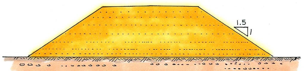
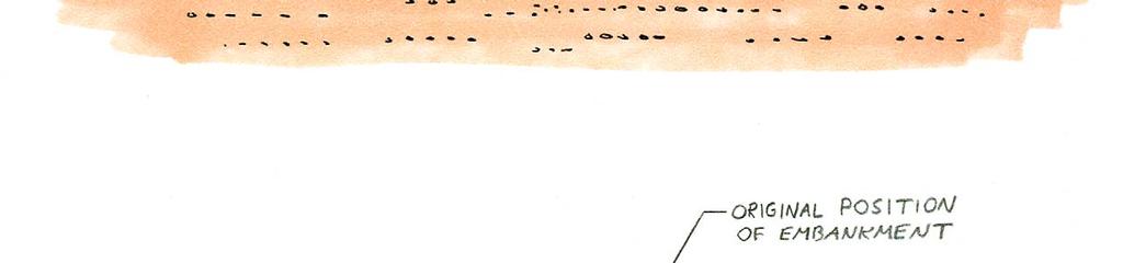
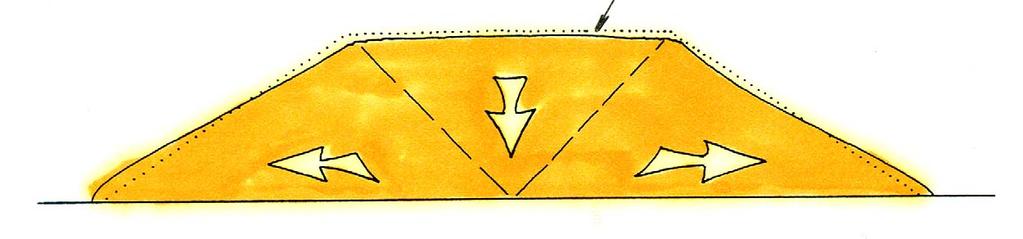
21 Mechanism of seismically-induced induced settlement of bridge approach fill prisms


22 QUAKE-INDUCED SETTLEMENT Approach fills for pile supported bridges commonly exhibit grievous differential settlement Impacts traffic flow and any entrained utilities, like fire mains These examples are from Aug 1999 Chi Chi earthquake in Taiwan


23 APPROACH FILL SETTLEMENT Seismically-induced induced settlement and lurching of approach fills for the Cayumapa River Bridge near Valdivia, Chile, which occurred during the M9.5 May 1960 earthquake Replacement structure being constructed in lower view, using Geofoam

24 Tschebotarioff (1973) presented case studies of pile supported bridges that failed because of approach fill settlement.


25 SETTLEMENT OF APPROACH FILL Crib wall supported approach fill for pile supported bridge. As fill consolidated, crib wall deformed and supporting piles deflected inward, towards channel. Taken from Tschetarioff (1973).

26 Farm lands west of Big Lake, AR reveal a series of linear fissures which disgorged liquefied sand from beneath a silt cover.


27 PALEOLIQUEFACTION STUDIES C14 dating of organics caught in sand boils and dikes are used to date past earthquakes. Three M7.5 to M8 paleoevents have been conclusively dated: ~1450, ~900 and ~550 AD.

28 Paleoliquefaction Assessments AD 900 AD 550 AD Shaded orange lines show most probable ages of major earthquakes in the NMSZ prior to (shown as dashed line)

29 Liquefaction of Confined Horizons Causes Lateral Spreads Lateral spreads were initially recognized and identified by USGS geologist Myron Fuller while studying the effects of the New Madrid earthquakes between Fuller made the sketch above, noting that: The depth of the openings was not usually very great, probably being in most cases limited to the hard clayey zone extending from the surface down to the quicksand which usually underlies the surface soil at depths of from 10 to 20 feet.
30 Block diagram of a lateral spread which evolved from post earthquake evaluations in Alaska by Walt Hansen in USGS Professional Paper 542-A A (1966)

31 LATERAL SPREADING Lateral spreads can exhibit different length-to to-depth ratios, depending on soil sensitivity. Liquefaction occurs along discrete horizons which are confined, allowing lateral translation of rafted material, usually towards open channels or depressions.

32 Divergent contours Stepped topography Headscarp evacuation grabens Arcuate headscarps Topographic Expression of Lateral Spreads Near Helena, Arkansas

33 Jeffersonville Lateral Spread Along Crowley s Ridge ~ 25 km north of Helena, Arkansas

34 Cross-section section through Jeffersonville Lateral Spread and Crowley s s Ridge The Jeffersonville Lateral Spread feature appears to have been triggered by the New Madrid earthquake sequence, with the ground translating easterly into the L Anguille River, near its mouth with the St. Francis River. The eastern escarpment of Crowley s Ridge is peppered with similar features.

35 WHAT IS SITE RESPONSE? Site response is used to describe the fundamental period of vibration generated by a typical earthquake at any particular site. If soft unconsolidated sediments overlie resistant bedrock an impedance contrast develops at this boundary y which causes incoming seismic energy to be absorbed at a rate faster than it can be transferred through the upper layers, causing significant amplification of ground g motions.


36 SITE RESPONSE VERSUS STRUCTURAL RESPONSE The fundamental period of vibration of any structure depends on its design and construction details. If the site period and structural period converge, a resonant frequency results which may be an order of magnitude greater than the natural site period, and the structure will be severely damaged or destroyed.

37 SOFT SEDIMENTS UNDERLYING MEXICO CITY Generalized geologic cross section of the southern margins of the lacustrine basin underlying Mexico City. The lacustrine sediments were covered with fill as the city developed. These soft materials amplified a the incoming seismic wave train from a M.8.1 earthquake located 52 km off the coast of Michoacan Province, some 350 km from Mexico City!

38 ZONE OF HEAVIEST DAMAGE DURING 1985 MEXICO CITY EARTHQUAKE Computed distribution of peak ground surface accelerations for typical t soil profiles in Mexico City, bounding the zone that experienced severe damage during the 1985 M. 8.1 Michoacan earthquake. The earthquake epicenter was 350 km from Mexico City and lasted close to 3 minutes. More than 500 buildings within the highlighted zone were severely damaged and 100 buildings between 6 and 22 stories high actually collapsed; killing 9,500, injuring 30,000 and leaving 100,000 homeless.

39 VARIANCE OF RESPONSE SPECTRA WITH SEDIMENT THICKNESS IN MEXICO CITY Response spectra calculated for different thicknesses of soft sediments in southern Mexico City, between downtown and Chapultepec Heights. Note impact of 30 to 45 m thickness.

40 MODES OF VIBRATION All structures posses fundamental modes of vibration which depend on their skeletal make-up: including material type, shear panels, connections, span distances and symmetry. This fundamental mode is known as the first mode of vibration and it generally controls the seismic design of most symmetrical structures. Secondary modes of vibration become increasingly important in complex structures with asymmetrical form or stiffness, or structures with damaged frames.

41 OUT-OF OF-PHASE MOTION Adjacent structures can react differently to seismic excitation, depending on focal aspects of incoming energy, long period motion, site amplification, and degrading structural response as frames become damaged
 likely pose the greatest seismic threat to highway infrastructure in the")
42 Geology Northern Mississippi Embayment Impedance contrasts within the Wisconsin age river channels (yellow) likely pose the greatest seismic threat to highway infrastructure in the Midwest.

43 WHAT IS THE DESIGN EARTHQUAKE? >M7.5 in ~550 >M7.5 in ~900 >M7.5 in ~1450 M7.5+ in 1811 M8.0 in 1812 M6.3 in 1843 M6.6 in 1895 M5.4 in 1968 M5.0 in 1987 M4.6 in 2002
44 Recurrence Intervals for New Madrid Earthquake Events* Magnitude Recurrence Interval Months Years Years Years Years * based on existing data; always subject to update and revision

45 1895 M6.6 Charleston, MO earthquake
46 1895 M6.6 Charleston, MO Quake October 31, 1895 Magnitude 6.6 Earthquake near Charleston Missouri. Modified Mercalli Intensity VIII Largest earthquake to occur in the Mississippi Valley region since the New Madrid earthquake sequence.. The estimated body-wave magnitude of this event is 5.9 and the surface-wave magnitude estimate is 6.7. People in 23 states felt this earthquake which caused extensive damage. to a number of structures in the Charleston region, including schools, churches, and homes. Structural damage and liquefaction were reported along a line from Bertrand, MO to Cairo, IL. The most severe damage occurred in Charleston, Puxico, and Taylor, Missouri; Alton, and Cairo, Illinois; Princeton, Indiana; and Paducah, Kentucky. The earthquake caused downed chimneys, cracked walls, shattered windows, and broken plaster to school buildings, churches, private houses, and to almost all the buildings in the commercial section of Charleston, MO.


47 Illinois Central Bridge at Cairo, IL At low water At high water The Illinois Central Railroad bridge across the Ohio River at Cairo, IL was the longest iron or steel bridge in world when completed in 1889 (4 miles). One of its masonry bents was cracked and severely damaged during Oct 1895 Charleston, MO quake
48 SHAKING INTENSITY versus DISTANCE Midwest quakes are less frequent, but much more lethal than California quakes because there is less damping of seismic energy.
49 MOST LIKELY QUAKE In our lifetimes, the most likely earthquake to impact St. Louis would be something similar to the Magnitude 6.6 Charleston, MO quake of 1895,, which has a recurrence frequency of 70+/- 15 years (overdue since 1980). It could emanate from either the New Madrid Zone or the Wabash Valley Fault Zone,, or even from south central Illinois
Identification of Lateral Spread Features in the Western New Madrid Seismic Zone J. David Rogers and Briget C. Doyle
 Identification of Lateral Spread Features in the Western New Madrid Seismic Zone J. David Rogers and Briget C. Doyle Department of Geological Engineering University of Missouri-Rolla rogersda@umr.edu doyle@hope.edu
What will a Magnitude 6.0 to 6.8 Earthquake do to the St. Louis Metro Area?
 What will a Magnitude 6.0 to 6.8 Earthquake do to the St. Louis Metro Area? J. David Rogers Natural Hazards Mitigation Center University of Missouri-Rolla USGS Mid-Continent Geographic Science Center Missouri
General Geologic Setting and Seismicity of the FHWA Project Site in the New Madrid Seismic Zone
 General Geologic Setting and Seismicity of the FHWA Project Site in the New Madrid Seismic Zone David Hoffman University of Missouri Rolla Natural Hazards Mitigation Institute Civil, Architectural & Environmental
Identification of Landslides Along Crowley s Ridge in the Upper Mississippi Embayment Using Topographic Algorithms
 Identification of Landslides Along Crowley s Ridge in the Upper Mississippi Embayment Using Topographic Algorithms Briget C. Doyle and J. David Rogers Department of Geological Engineering Department of
I. Locations of Earthquakes. Announcements. Earthquakes Ch. 5. video Northridge, California earthquake, lecture on Chapter 5 Earthquakes!
 51-100-21 Environmental Geology Summer 2006 Tuesday & Thursday 6-9:20 p.m. Dr. Beyer Earthquakes Ch. 5 I. Locations of Earthquakes II. Earthquake Processes III. Effects of Earthquakes IV. Earthquake Risk
Magnitude 6.3 SOUTH ISLAND OF NEW ZEALAND
 A magnitude 6.3 earthquake shook the southern New Zealand city of Christchurch. At least 100 people are reported dead, and there are reports of collapsed buildings, cracked streets and flooding due to
Earthquakes and Earth s Interior
 - What are Earthquakes? Earthquakes and Earth s Interior - The shaking or trembling caused by the sudden release of energy - Usually associated with faulting or breaking of rocks - Continuing adjustment
New Madrid and Central U.S. Region Earthquake Hazard
 New Madrid and Central U.S. Region Earthquake Hazard Rob Williams U.S. Geological Survey, Golden, CO March 16, 2017 Reelfoot Lake, TN U.S. Department of the Interior U.S. Geological Survey 1811-12 New
Three Fs of earthquakes: forces, faults, and friction. Slow accumulation and rapid release of elastic energy.
 Earthquake Machine Stick-slip: Elastic Rebound Theory Jerky motions on faults produce EQs Three Fs of earthquakes: forces, faults, and friction. Slow accumulation and rapid release of elastic energy. Three
Important Concepts. Earthquake hazards can be categorized as:
 Lecture 1 Page 1 Important Concepts Monday, August 17, 2009 1:05 PM Earthquake Engineering is a branch of Civil Engineering that requires expertise in geology, seismology, civil engineering and risk assessment.
Micro Seismic Hazard Analysis
 Micro Seismic Hazard Analysis Mark van der Meijde INTERNATIONAL INSTITUTE FOR GEO-INFORMATION SCIENCE AND EARTH OBSERVATION Overview Site effects Soft ground effect Topographic effect Liquefaction Methods
appendix e: geologic and seismic hazards
 appendix e: geologic and seismic hazards CONTENTS: E-2 Fault Rupture E-3 Ground Shaking E-5 Seismic Ground Deformation E-5 Liquification E-6 Seismically Induces Landslide E-6 Landslide Hazard E The following
Earthquake Hazards. Tsunami
 Earthquake Hazards Tsunami Review: What is an earthquake? Earthquake is the vibration (shaking) and/or displacement of the ground produced by the sudden release of energy. The point inside the Earth where
Earthquake Hazards. Tsunami
 Earthquake Hazards Tsunami Measuring Earthquakes Two measurements that describe the power or strength of an earthquake are: Intensity a measure of the degree of earthquake shaking at a given locale based
Paleoseismic Investigations for Determining the Design Ground Motions for Nuclear Power Plants
 Paleoseismic Investigations for Determining the Design Ground Motions for Nuclear Power Plants Russell A. Green Department of Civil and Environmental Engineering Purdue Geotechnical Society Workshop May
SECTION 3. Housing. EAppendix E GEOLOGIC AND SEISMIC HAZARDS
 SECTION 3 Housing EAppendix E GEOLOGIC AND SEISMIC HAZARDS E-2 Housing Commission Attachment B Appendix E Geologic and Seismic Hazards The following definitions provide a more comprehensive discussion
Earthquake Hazards. Tsunami
 Earthquake Hazards Tsunami Review: What is an earthquake? Earthquake is the vibration (shaking) and/or displacement of the ground produced by the sudden release of energy. The point inside the Earth where
Mw 7.8, Southwest of Sumatra, Indonesia Wed, 2 March 2016 at 12:49:48 UTC M /03/03
 Earthquake overview AFGHANISTA N PAKISTA N INDIA A moment magnitude (Mw) 7.8 earthquake struck in South West, Indonesia. The epicentre was centered about 800 km West South West of Padang, Sumatra province,
Earthquakes.
 Earthquakes http://thismodernworld.com/comic-archive Elastic rebound http://projects.crustal.ucsb.edu/understanding/elastic/rebound.html Elastic rebound Rocks store energy elastically When stored stress
EPS 20: Earthquakes. Laboratory Exercise 1. Intensity
 Name GSI Name EPS 20: Earthquakes Laboratory Exercise 1 Intensity Purpose: To investigate seismic intensity and how it is used to describe the effects of earthquakes Background: Several hundred years ago,
To present information on the history, consequences, and existing threat of moderate to major eaythquakes in Arkansas.
 THE NATURE OF THE EARTHQUAKE THREAT OBJECTIVE To present information on the history, consequences, and existing threat of moderate to major eaythquakes in Arkansas. When people know what to expect in an
Earthquakes Earth, 9th edition, Chapter 11 Key Concepts What is an earthquake? Earthquake focus and epicenter What is an earthquake?
 1 2 3 4 5 6 7 8 9 10 Earthquakes Earth, 9 th edition, Chapter 11 Key Concepts Earthquake basics. "" and locating earthquakes.. Destruction resulting from earthquakes. Predicting earthquakes. Earthquakes
Geology 229 Engineering Geology Lecture 27. Earthquake Engineering (Reference West, Ch. 18)
") Geology 229 Engineering Geology Lecture 27 Earthquake Engineering (Reference West, Ch. 18) Earthquake Engineering 1. General introduction of earthquakes 2. Seismic Hazards 3. Strong ground motion Exactly
Geology 229 Engineering Geology Lecture 27 Earthquake Engineering (Reference West, Ch. 18) Earthquake Engineering 1. General introduction of earthquakes 2. Seismic Hazards 3. Strong ground motion Exactly
Synthetic Near-Field Rock Motions in the New Madrid Seismic Zone
 Synthetic Near-Field Rock Motions in the New Madrid Seismic Zone Genda Chen*, Ph.D., P.E., and Mostafa El-Engebawy Engebawy,, Ph.D. *Associate Professor of Civil Engineering Department of Civil, Architecture
Earthquakes and Earth s Chapter. Interior
 Earthquakes and Earth s Chapter Interior 8.1 What Is an Earthquake? An earthquake is the vibration of Earth produced by the rapid release of energy Focus and Epicenter Focus is the point within Earth
Section 19.1: Forces Within Earth Section 19.2: Seismic Waves and Earth s Interior Section 19.3: Measuring and Locating.
 CH Earthquakes Section 19.1: Forces Within Earth Section 19.2: Seismic Waves and Earth s Interior Section 19.3: Measuring and Locating Earthquakes Section 19.4: Earthquakes and Society Section 19.1 Forces
Earthquakes An introduction to earthquake monitoring techniques
 Earthquakes An introduction to earthquake monitoring techniques TEACHER S COPY Aims To understand what an earthquake is and where they occur To gain an insight into how earthquakes are recorded and how
20.1 Earthquakes. Chapter 20 EARTHQUAKES AND VOLCANOES. Earthquakes and plate boundaries 500 UNIT 6 EARTH S STRUCTURE
 Chapter 20 EARTHQUAKES AND VOLCANOES 20.1 Earthquakes In Chapter 19, you read about the San Andreas Fault, which lies along the California coast (Figure 20.1). This fault passes right through San Francisco
Earthquakes and Faulting
 Earthquakes and Faulting Crustal Strength Profile Quakes happen in the strong, brittle layers Great San Francisco Earthquake April 18, 1906, 5:12 AM Quake lasted about 60 seconds San Francisco was devastated
Earthquakes. Chapter Test A. Multiple Choice. Write the letter of the correct answer on the line at the left.
 Earthquakes Chapter Test A Multiple Choice Write the letter of the correct answer on the line at the left. 1. Stress that pushes a mass of rock in two opposite directions is called a. shearing. b. tension.
UGRC 144 Science and Technology in Our Lives/Geohazards
 UGRC 144 Science and Technology in Our Lives/Geohazards Session 3 Understanding Earthquakes and Earthquake Hazards Lecturer: Dr. Patrick Asamoah Sakyi Department of Earth Science, UG Contact Information:
Geotechnical Aspects of the Seismic Update to the ODOT Bridge Design Manual. Stuart Edwards, P.E Geotechnical Consultant Workshop
 Geotechnical Aspects of the Seismic Update to the ODOT Bridge Design Manual Stuart Edwards, P.E. 2017 Geotechnical Consultant Workshop Changes Role of Geotechnical Engineer Background Methodology Worked
Tsunami waves swept away houses and cars in northern Japan and pushed ships aground.
 Japan was struck by a magnitude 8.9 earthquake off its northeastern coast Friday. This is one of the largest earthquakes that Japan has ever experienced. In downtown Tokyo, large buildings shook violently
Module 2, Investigation 1: Earthquake Hazards
 Module 2, Investigation 1: Earthquake Hazards Introduction Welcome! In the last module, you assumed the role of a volcanologist and learned how volcanoes are described and monitored. You will now assume
Earthquakes. Earthquake Magnitudes 10/1/2013. Environmental Geology Chapter 8 Earthquakes and Related Phenomena
 Environmental Geology Chapter 8 Earthquakes and Related Phenomena Fall 2013 Northridge 1994 Kobe 1995 Mexico City 1985 China 2008 Earthquakes Earthquake Magnitudes Earthquake Magnitudes Richter Magnitude
Magnitude 6.3, NORTH OF MOROCCO
 Earthquake location & overview A magnitude 6.3 earthquake struck in Alboran Sea, orth of Morocco; the epicentre was centered about 54 km ( 34 miles) E of Al Hoceima. The depth has been estimated to be
Lecture Outline Wednesday-Monday April 18 23, 2018
 Lecture Outline Wednesday-Monday April 18 23, 2018 Questions? Lecture Final Exam Lecture Section 1 Friday May 4, 8:00-10:00am Lecture Section 2 Friday May 4, 3:10-5:10 pm Final Exam is 70% new material
SEISMIC HAZARD ANALYSIS. Instructional Material Complementing FEMA 451, Design Examples Seismic Hazard Analysis 5a - 1
 SEISMIC HAZARD ANALYSIS Instructional Material Complementing FEMA 451, Design Examples Seismic Hazard Analysis 5a - 1 Seismic Hazard Analysis Deterministic procedures Probabilistic procedures USGS hazard
2/8/2016 Magnitude-6.3 earthquake near Tainan, Taiwan, highlights the danger of blind thrust faults around the world
 Temblor.net Earthquake News & Blog Magnitude-6.3 earthquake near Tainan, Taiwan, highlights the danger of blind thrust faults around the world 6 February 2016 Quake Insight Revised The 5 Feb 2016 M=6.3
Earthquakes in Oregon: Past, Present & Future. Earthquakes in OREGON: Are we ready for the Big One?
 Earthquakes in Oregon: Past, Present & Future Earthquakes in OREGON: Are we ready for the Big One? Scott Burns Portland State University Department of Geology New Yorker Article: 7/20/15 The Really Big
New USGS Maps Identify Potential Ground- Shaking Hazards in 2017
 New USGS Maps Identify Potential Ground- Shaking Hazards in 2017 New USGS Maps Identify Potential Ground-Shaking Hazards in 2017 The central U.S. faces continued hazards from human-induced earthquakes
Natural Disasters Spring, LECTURE #8: Earthquake Disasters: Monitoring & Mitigation. Date: 1 Feb 2018 (lecturer: Dr.
 GEOL 0820 Ramsey Natural Disasters Spring, 2018 LECTURE #8: Earthquake Disasters: Monitoring & Mitigation Date: 1 Feb 2018 (lecturer: Dr. Shawn Wright) I. Exam I - Reminder Feb 6 th next class details:
b. Why is the area affected by each earthquake circular or nearly circular? Where is the epicenter of each quake located?
 Name: Skill Sheet 29-A Interpreting Geologic Hazard Maps Plate tectonics and the weather are often the cause of geologic hazards such as earthquakes, volcanic eruptions, and flooding. Geologic hazard events
GEOLOGY, SOILS, AND SEISMICITY
 4.9 GEOLOGY, SOILS, AND SEISMICITY 4.9.1 Introduction Information about the geological conditions and seismic hazards in the study area was summarized in the FEIR, and was based on the Geotechnical Exploration
Magnitude 7.7 QUEEN CHARLOTTE ISLANDS REGION
 A major 7.7 magnitude earthquake struck at 8:04 PM local time in western British Columbia, Canada. The epicenter is located on Moresby Island, the southern large island in the Queen Charlotte Islands region.
Earthquake Risk in Canada and the National Building Code
 Earthquake Risk in Canada and the National Building Code Tuna Onur, Ph.D. Onur Seemann Consulting, Inc. NICC, Vancouver, BC, 28-30 September 2016 Southwestern Canada: Cascadia Subduction Zone + Crustal
Section Forces Within Earth. 8 th Grade Earth & Space Science - Class Notes
 Section 19.1 - Forces Within Earth 8 th Grade Earth & Space Science - Class Notes Stress and Strain Stress - is the total force acting on crustal rocks per unit of area (cause) Strain deformation of materials
Seismic Waves. 1. Seismic Deformation
 Types of Waves 1. Seismic Deformation Seismic Waves When an earthquake fault ruptures, it causes two types of deformation: static; and dynamic. Static deformation is the permanent displacement of the ground
An entire branch of Earth science, called, is devoted to the study of earthquakes.
 Lesson One Essential Question Where do earthquakes take place? What causes earthquakes? What are three different types of faults that occur at plate boundaries? How does energy from earthquakes travels
Earthquake. earthquake, epicenters in the U.S. Kobe, Japan deaths
 Kobe, Japan 1995 5000 deaths Earthquakes It is estimated that there are 500,000 detectable earthquakes in the world each year. 100,000 of those can be felt, and 100 of them cause damage. The world's deadliest
Magnitude 7.0 SOUTH ISLAND OF NEW ZEALAND
 A powerful 7.0-magnitude earthquake shook much of New Zealand's South Island early Saturday morning local time. USGS A damaged building near Manchester St. New Zealand Herald Photo / Colin Cross A car
Dynamic Crust Regents Review
 Name Dynamic Crust Regents Review Base your answers to questions 1 through 3 on the table below, which lists the location of some earthquakes, their Richter magnitude, and their year of occurrence. Data
Earthquakes. Earthquakes and Plate Tectonics. Earthquakes and Plate Tectonics. Chapter 6 Modern Earth Science. Modern Earth Science. Section 6.
 Earthquakes Chapter 6 Modern Earth Science Earthquakes and Plate Tectonics Section 6.1 Modern Earth Science Earthquakes and Plate Tectonics Earthquakes are the result of stresses in Earth s s lithosphere.
Lecture 15: Subsidence
 Lecture 15: Subsidence Key Questions 1. How does removal of groundwater cause subsidence on a regional scale? 2. Under what conditions does a building sink into sediment? 3. Why do clays consolidate more
Tsukuba, Japan International Institute of Seismology and Earthquake Engineering Building Research Institute STUDY TRIP TO ITAKO CITY
 Tsukuba, Japan International Institute of Seismology and Earthquake Engineering Building Research Institute STUDY TRIP TO ITAKO CITY A Technical Report By MARTINEZ BRAVO Delvin Abdiel (MEE10515) Disaster
An earthquake can cause:
 Earthquakes An earthquake is a sudden rapid shaking of the earth. They are caused by the breaking and shifting of the rock beneath the earth s surface. Often found in conjunction with Plate tectonic boundaries.
Magnitude 7.1 PERU. There are early reports of homes and roads collapsed leaving one dead and several dozen injured.
 A magnitude 7.1 earthquake has occurred offshore Peru. The earthquake struck just after 4 a.m. local time and was centered near the coast of Peru, 40 km (25 miles) south-southwest of Acari, Peru at a depth
Earthquakes and Earthquake Hazards Earth - Chapter 11 Stan Hatfield Southwestern Illinois College
 Earthquakes and Earthquake Hazards Earth - Chapter 11 Stan Hatfield Southwestern Illinois College What Is an Earthquake? An earthquake is the vibration of Earth, produced by the rapid release of energy.
Magnitude 7.1 NEAR THE EAST COAST OF HONSHU, JAPAN
 Japan was rattled by a strong aftershock and tsunami warning Thursday night nearly a month after a devastating earthquake and tsunami flattened the northeastern coast. This earthquake can be considered
Seismic vulnerability in Latinamerica Speaker: Rafael Osiris de León Sciences Academy of Dominican Republic.
 Seismic vulnerability in Latinamerica Speaker: Rafael Osiris de León Sciences Academy of Dominican Republic. IANAS GENERAL ASSEMBLY Punta Cana, 16-20 July, 2013 TECTONIC PLATES AND EARTHQUAKES Pacific
September 28, 2004 Parkfield Earthquake
 PRELIMINARY REPORT ON SEPTEMBER 28, 2004 PARKFIELD EARTHQUAKE By Rakesh K. Goel, M.EERI and Charles B. Chadwell, M. EERI Department of Civil & Environmental Engineering, California Polytechnic State University,
What is an earthquake?
 What is an earthquake? Shaking or vibration of the ground rocks undergoing deformation break suddenly along a fault 1906 San Francisco earthquake Oblique view of the San Andreas fault and San Francisco
Magnitude 7.2 OAXACA, MEXICO
 A magnitude 7.2 earthquake has occurred in Oaxaca, Mexico at a depth of 24.6 km (15 miles). It was felt as far away as Guatemala. There have been no reported deaths directly linked to the earthquake. Emergency
(First Edition: prepared on 29/12/2003)
") (First Edition: prepared on 29/12/2003) Dr Sassan Eshghi 1 and Dr Mehdi Zaré 2 International Institute of Earthquake Engineering and Seismology, Tehran, P.O.Box: 19395/3913, IRAN e-mails: 1)s.eshghi@iiees.ac.ir,
(First Edition: prepared on 29/12/2003) Dr Sassan Eshghi 1 and Dr Mehdi Zaré 2 International Institute of Earthquake Engineering and Seismology, Tehran, P.O.Box: 19395/3913, IRAN e-mails: 1)s.eshghi@iiees.ac.ir,
New Madrid Fault. Seismic Squirrels Jacob Berthold, Dylan Cardwell, Scott DeRycke, Sarah Ojito CAO 29 NOV 11
 New Madrid Fault Seismic Squirrels Jacob Berthold, Dylan Cardwell, Scott DeRycke, Sarah Ojito CAO 29 NOV 11 Overview Mass Education New Madrid Fault Arkansas Seismic Events National Seismic Events Global
Identifying the causes and effects of earthquakes
 Science 3 Physical Earth and Space Life LESSON 57 Identifying the causes and effects of earthquakes Lesson Preparation Program Materials Child s Booklet E Exploring the Earth s Structure (pp. 12 13) Optional:
LAB 9: Earthquakes & Seismic Activity
 LAB 9: Earthquakes & Seismic Activity Objectives Identify P, S, and surface waves on a simple seismogram Locate the epicenter of an earthquake using seismograms and travel times curves Describe how the
New Findings Form Basis for Earthquake
 Page 1 of 5 enter key Advanced Se Español Français Pycckuú You Are In: USINFO > Products >Washfile 10 November 2005 New Findings Form Basis for Earthquake Warning System Tracking quake waves could give
3.18 GEOLOGY AND SOILS
 3.18 GEOLOGY AND SOILS This section discusses geologic resource concerns as they relate to the environment, public safety, and project design both during construction and after completion of the project.
Released Science Inquiry Task Location Grade 11
 Date: Your Name: Released Science Inquiry Task Location 2009 Grade 11 Science Directions: You will be completing an extended-response inquiry task called Location. Explain the reasons for all of your answers.
New Madrid Earthquakes
 Seismic Hazard Maps A presentation by Dr. Chris Cramer, U.S. Geological Survey, Memphis, TN at University of Memphis, TN November 22, 2004 1811-12 New Madrid Earthquakes 1 1886 Charleston Earthquake 2
Part 2 - Engineering Characterization of Earthquakes and Seismic Hazard. Earthquake Environment
 Part 2 - Engineering Characterization of Earthquakes and Seismic Hazard Ultimately what we want is a seismic intensity measure that will allow us to quantify effect of an earthquake on a structure. S a
IV. ENVIRONMENTAL IMPACT ANALYSIS E. GEOLOGY AND SOILS
 IV. ENVIRONMENTAL IMPACT ANALYSIS E. GEOLOGY AND SOILS The following section is a summary of the geotechnical report conducted for the Proposed Project. The Geotechnical Engineering Investigation (the
Pilot Seismic Hazard Assessment of the Granite City, Monks Mound, and Columbia Bottom Quadrangles, St. Louis Metropolitan Area
 Pilot Seismic Hazard Assessment of the Granite City, Monks Mound, and Columbia Bottom Quadrangles, St. Louis Metropolitan Area Research Proposal Submitted by Deniz Karadeniz Ph.D. Candidate in Geological
Development of U. S. National Seismic Hazard Maps and Implementation in the International Building Code
 Development of U. S. National Seismic Hazard Maps and Implementation in the International Building Code Mark D. Petersen (U.S. Geological Survey) http://earthquake.usgs.gov/hazmaps/ Seismic hazard analysis
Goals In this activity you will:
 Activity 3 How Big Was It? Goals In this activity you will: Rank the effects of earthquakes. Map the intensity of earthquakes. Interpret a map of earthquake intensity to infer the general location of the
NPTEL Video Course on Geotechnical Earthquake Engineering
 NPTEL Video Course on Geotechnical Earthquake Engineering by Prof. Deepankar Choudhury Professor, Dept. of Civil Engg., Indian Institute of Technology (IIT) Bombay Powai, Mumbai 400076, India. Email: dc@civil.iitb.ac.in
Chapter 11 10/30/2013. Mass Wasting. Introduction. Factors That Influence Mass Wasting. Introduction. Factors That Influence Mass Wasting
 Introduction Chapter 11 Mass wasting - The downslope movement of material resulting from the force of gravity. Mass Wasting Mass wasting results when the force of gravity acting on a slope exceeds the
4.10 GEOLOGY, SOILS, AND SEISMICITY
 4.10 GEOLOGY, SOILS, AND SEISMICITY 4.10.1 INTRODUCTION This section describes the geology of the SVRTC and the susceptibility of site soils to seismically induced hazards. Faults in the corridor and past
Measuring the Size of an Earthquake
 Earthquake Hazard Information Hazard, Risk, Magnitude, Intensity, Earthquake Statistics Part 1 (Information for interpreting the results of building contest and shake table testing; L. Braile, 03/12/03)
In the early morning hours of
 Figure 1. Brace that Chimney! Bracing of masonry chimneys is very difficult to do properly and has generally been ineffective in preventing their failure during earthquakes. While replacement of the chimney
Directed Reading. Section: How and Where Earthquakes Happen WHY EARTHQUAKES HAPPEN. Skills Worksheet. 1. Define earthquake.
 Skills Worksheet Directed Reading Section: How and Where Earthquakes Happen 1. Define earthquake. 2. When do earthquakes usually occur? 3. What is a fault? WHY EARTHQUAKES HAPPEN 4. Rocks along both sides
Probabilistic Earthquake Risk Assessment of Newcastle and Lake Macquarie Part 1 Seismic Hazard.
 Probabilistic Earthquake Risk Assessment of Newcastle and Lake Macquarie Part 1 Seismic Hazard. T. Dhu, D. Robinson, C. Sinadinovski, T. Jones, A. Jones & J. Schneider Geoscience Australia, Canberra, Australia.
Magnitude 7.0 PAPUA, INDONESIA
 A 7.0 magnitude earthquake struck eastern Indonesia's mountainous West Papua province on Saturday but there were no immediate reports of casualties or damage. The region is sparsely populated. According
Subject: Establishing Seismic Measuring Devices on Structures in So. Nevada Date: Wed, 27 Feb :58:
 Subject: Establishing Seismic Measuring Devices on Structures in So. Nevada Date: Wed, 27 Feb 2002 11:58:38 0800 Committee Members: Burt Slemmons Samaan Ladkanay Jim O Donnell Cathy Snelson Ron Lynn The
What is an Earthquake?
 Earthquakes What is an Earthquake? Earthquake - sometimes violent shaking of ground caused by movement of Earth s tectonic plates; creates seismic waves Often followed by smaller earthquakes (aftershocks);
1. Why do earthquakes happen? 3. What type of mechanical waves are Primary or P waves? 4. What type of mechanical waves are Secondary or S waves?
 Name Period Earthquake Activity Background Information Earthquakes occur because of a sudden release of stored energy. This energy has built up over long periods of time as a result of tectonic forces
VIDEO The 2011 Japanese Earthquake and Tsunami
 VIDEO The 2011 Japanese Earthquake and Tsunami Why was it so large and devastating? Why so short a warning? Why did tsunami precautions fail? What happened elsewhere? The Loma Prieta Earthquake (1989)
On May 4, 2001, central Arkansas experienced an M=4.4 earthquake followed by a
 1. Introduction On May 4, 2001, central Arkansas experienced an M=4.4 earthquake followed by a surprisingly large number of small earthquakes. We recorded about 2500 above the ambient noise level on a
Comparison between predicted liquefaction induced settlement and ground damage observed from the Canterbury earthquake sequence
 Power, P.M. & Jacka, M. (2013) the Canterbury earthquake sequence Proc. 19 th NZGS Geotechnical Symposium. Ed. CY Chin, Queenstown Comparison between predicted liquefaction induced settlement and ground
Earthquakes!! Be sure to fill in your notes sheet as you go through the power point!
 Earthquakes!! Be sure to fill in your notes sheet as you go through the power point! Plate Boundary Review Click on the link below to try some plate boundary movement simulations. The link will take you
The Earthquake Cycle Chapter :: n/a
 The Earthquake Cycle Chapter :: n/a A German seismogram of the 1906 SF EQ Image courtesy of San Francisco Public Library Stages of the Earthquake Cycle The Earthquake cycle is split into several distinct
Objectives. Vocabulary
 Forces Within Earth Objectives Define stress and strain as they apply to rocks. Distinguish among the three types of faults. Contrast three types of seismic waves. Vocabulary stress strain fault primary
Earthquakes & Volcanoes
 Earthquakes & Volcanoes Geology - the study of solid Earth, the rocks of which it is composed, and the processes by which they change geo = Earth; ology = study of Earth s Layers Plate Tectonics - the
Unit 7: Dynamic Planet: Earthquakes & Volcanoes
 Unit 7: Dynamic Planet: Earthquakes & Volcanoes Lecture 3 Objectives: E3.4C - Describe the effects of earthquakes and volcanic eruptions on humans. E3.4f - Explain why fences are offset after an earthquake
Forces in Earth s Crust
 Name Date Class Earthquakes Section Summary Forces in Earth s Crust Guide for Reading How does stress in the crust change Earth s surface? Where are faults usually found, and why do they form? What land
Effects of Surface Geology on Seismic Motion
 4 th IASPEI / IAEE International Symposium: Effects of Surface Geology on Seismic Motion August 23 26, 2011 University of California Santa Barbara LONG-PERIOD (3 TO 10 S) GROUND MOTIONS IN AND AROUND THE
PHYSICAL SCIENCE FINAL
 PHYSICAL SCIENCE FINAL Liquefaction Doreen Wallace, Tesla Grogan, Amber Ward, Erik Garcia, Cinthia Salas, Alexis Albers Liquefaction What is it? Conditions needed How it works Effects of Liquefaction Soil
Screening guide for critical river crossing structures with earthquake disruption risks.
 University of Louisville ThinkIR: The University of Louisville's Institutional Repository Electronic Theses and Dissertations 8-2006 Screening guide for critical river crossing structures with earthquake
ENGINEER S CERTIFICATION OF FAULT AREA DEMONSTRATION (40 CFR )
") PLATTE RIVER POWER AUTHORITY RAWHIDE ENERGY STATION BOTTOM ASH TRANSFER (BAT) IMPOUNDMENTS LARIMER COUNTY, CO ENGINEER S CERTIFICATION OF FAULT AREA DEMONSTRATION (40 CFR 257.62) FOR COAL COMBUSTION RESIDUALS
PLATTE RIVER POWER AUTHORITY RAWHIDE ENERGY STATION BOTTOM ASH TRANSFER (BAT) IMPOUNDMENTS LARIMER COUNTY, CO ENGINEER S CERTIFICATION OF FAULT AREA DEMONSTRATION (40 CFR 257.62) FOR COAL COMBUSTION RESIDUALS