Earthquake and Tsunami Guide
|
|
|
- Gregory Hall
- 6 years ago
- Views:
Transcription

1 Earthquake and Tsunami Guide

2 PreparedBC EARTHQUAKE AND TSUNAMI GUIDE A Narrative of Huu-ay-aht Seismic History On January 26, 1700 at about 9 pm, a powerful magnitude 9 earthquake struck off the coast of BC, and without warning was followed by a catastrophic tsunami that devastated the village of Loht a. With no time to respond, all 5,000 residents of Loht a were lost to this devastating event. This is the story of the Great Earthquake and Tsunami that was told to me by my grandparents, George and Louisa Johnson. For generations, Elders in our community as well as other First Nations along the coast have maintained this legend, and others like it, as an oral history of our people. Today, our people call Anacla (Pachena Bay) home and this oral history plays a central role in how we understand tsunami risks in our community. We are able to use our history to learn from the past and prepare for future tsunamis. by Robb Johnson from Huu-ay-aht First Nation 2 From top right, George and Louisa Johnson, Robb Johnson, Pachena Bay on the west coast of Vancouver Island.

3 EARTHQUAKE AND TSUNAMI GUIDE A Seismically Active Province Earthquakes are common in British Columbia, with an average of 3,000 reported each year. Most are too small to be felt, but earthquakes strong enough to cause structural damage happen, on average, once per decade. There is a good chance one of these earthquakes could be the big one. The most at-risk regions of British Columbia are along the west coast, where the threat of a destructive tsunami is also very real. It s vital that all British Columbians take time to prepare and understand what to do both during and after a major earthquake and tsunami. The information in this guide can help you get started. Download it and other PreparedBC resources, such as the Household Emergency Plan and In it Together: Neighbourhood Preparedness Guide from 3
4 PreparedBC EARTHQUAKE AND TSUNAMI GUIDE Know the Risks Earthquakes Tectonic plates on the earth s surface are constantly moving apart, sliding past one another or colliding. It s this movement that causes earthquakes, both big and small. Earthquakes can t be predicted they happen suddenly. The first sign can be a loud bang or roar. You may then feel the ground shake and roll for several minutes. Aftershocks, or smaller earthquakes, can continue for many hours, even days. In BC, earthquakes are concentrated in four settings: 1. Earthquakes along the Cascadia Subduction Zone happen when the Juan de Fuca Plate moves under the North American Plate. These types of earthquakes have the highest magnitudes and will trigger a tsunami. 2. Deep earthquakes occur well below the earth s surface, within the subducting Juan de Fuca Plate, and typically result in weaker shaking. 3. Crustal earthquakes occur within the North American Plate, close to the earth s surface and, depending on their magnitude, can cause significant damage. 4. Earthquakes along the Queen Charlotte Fault, off Haida Gwaii, happen when the Pacific Plate slides past the North American Plate horizontally. These earthquakes have been some of the largest recorded in BC. No matter the type or location of an earthquake, individuals need to prepare and understand how to respond. The five biggest earthquakes to strike within BC occurred in 1700, 1946, 1949, 1970 and They ranged in magnitude from 7.3 (1946) to 9.0 (1700). 4

5 EARTHQUAKE AND TSUNAMI GUIDE 5

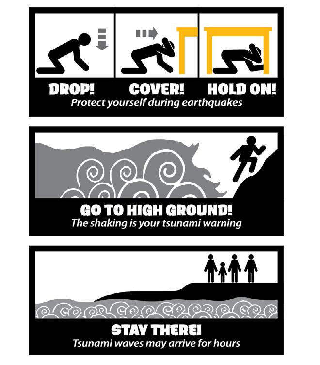
6 PreparedBC EARTHQUAKE AND TSUNAMI GUIDE Drop, Cover and Hold On When you feel the ground shake, immediately Drop, Cover and Hold On. These three simple steps have saved lives in earthquake zones around the world. Drop to your hands and knees. This position prevents you from falling, but allows you to move if necessary. If you re inside, stay inside. Don t run outdoors or to other rooms. Most injuries occur when people are knocked over or struck by flying debris. Cover your head and neck with your arm and take shelter under a sturdy piece of furniture. If there is no shelter nearby, crawl to the nearest interior corner or wall while continuing to protect your head and neck. Hold On to your shelter, covering your head and neck until the shaking stops. Count to 60 before getting up, giving unanchored objects time to settle. Move cautiously, looking for hazards from above and below. Check gas, water and electrical lines. Be aware that there may be other hazards caused by an earthquake, including fire, landslides and liquefaction. 6

7 EARTHQUAKE AND TSUNAMI GUIDE Next Steps Stay in your home if it s safe to do so. If your house has suffered considerable damage and poses a risk, leave immediately. The same applies if you re directed to evacuate by local authorities. Take your graband-go bags and listen to official instructions via reliable sources. Reception centres may be opened to help with food and lodging, and for those who have been injured. Only call 911 for life-threatening emergencies. Always anticipate aftershocks. Drop, Cover and Hold On during aftershocks as well. Practice Drop, Cover and Hold On at home and work so it s second nature during an earthquake. Join others by participating in the annual Great British Columbia ShakeOut. Register today at 7

8 PreparedBC EARTHQUAKE AND TSUNAMI GUIDE Make a Plan Phone, gas, electric and water services may be disrupted following an earthquake. Roads could be blocked, stores closed and gas stations outof-service. You and your family could be on your own for several days while emergency responders work to save lives and manage the aftermath. It may be weeks before infrastructure, utilities and essential services are restored. Thinking ahead and creating an emergency plan will strengthen your ability to respond and recover. Remember to consider the unique requirements of everyone in your home, such as children, pets and those with additional preparedness needs. Download PreparedBC s fill-in-the-blanks emergency plan from and complete it with the members of your household Identify the risks for your region. Make an emergency phone list with at least one out-of-area contact. Pick a meeting spot if you re separated from family members. Pick a meeting spot if you re separated from family members. Identify what official sources you ll get information from Learn how to turn off utilities. Store enough emergency water for your family. Store enough emergency food for three days to one week. Identify any special needs, such as medications, and make sure a proper supply is on hand. Secure your space. Create grab-and-go bags. 8

9 EARTHQUAKE AND TSUNAMI GUIDE Store Emergency Supplies If your house, apartment or condominium is structurally sound following an earthquake, the best thing you can do is shelter-in-place. In other words stay home. This will help first responders do their job and ensure emergency reception centres are available to those who need them most. Collect enough non-perishable food, water and emergency supplies to support your household for a minimum of three days, although your target should be a week to two weeks. Make sure everything is stored together in an accessible location. You should also prepare grab-and-go bags for each family member, including pets, in case you have to leave your home. These should be smaller versions of your basic household emergency kit, but customized to meet unique personal or medical needs. Ensure the bags are accessible and that everyone knows where they are. Live in a multi-unit building? Download PreparedBC s Apartment, Condominium and Townhouse guide for information on storing supplies collectively. 9

10 PreparedBC EARTHQUAKE AND TSUNAMI GUIDE Prepare your Home Severe shaking can topple large furniture and appliances, toss heavy items from walls and shelves, and throw open cupboards. To prevent these things from happening: Secure tall, free-standing furniture, such as bookcases, cabinets and shelving to wall studs using L brackets, corner brackets or anodized aluminum moulding. Move framed pictures and mirrors away from beds, couches and chairs. Secure cabinet doors with push or pull latches. Use strong strapping and ratchets or other connectors to secure refrigerators, freezers, washers and dryers. Anchor water heaters snugly to the wall with straps. If necessary, contract a licensed gas fitter to install a flexible gas line. 10

11 EARTHQUAKE AND TSUNAMI GUIDE You should also know how to turn off your home s electrical panel, water and gas valves in case of leaks or if you re instructed to do so by local officials. IMPORTANT: If you suspect a gas leak, turn off the gas valve and leave immediately. Once the gas is shut off at the meter, DON T try to turn it back on. Only a registered gas contractor can do that safely. Whether you rent or own, insurance is available to help you rebuild and replace your belongings after a loss. Review your policy on an annual basis to ensure you re adequately protected. Contact your insurance representative or the Insurance Bureau of Canada at for information regarding home insurance, including whether earthquake insurance is available to you. 11

12 PreparedBC EARTHQUAKE AND TSUNAMI GUIDE Basic Emergency Supply Kit First Aid kit and medications A three-day to oneweek supply of nonperishable food and manual can opener Battery-powered or hand crank radio Battery-powered or hand crank flashlight with extra batteries Whistle to signal for help Cell phone with chargers, inverter or solar charger Copy of your emergency plan, copies of important documents and cash in small bills Garbage bags, moist towelettes and plastic ties for personal sanitation Water, four litres per person per day, for three days to one week, for drinking and sanitation Dust mask to help filter contaminated air Seasonal clothing and footwear 12

13 EARTHQUAKE AND TSUNAMI GUIDE Know the Risks Tsunamis Tsunamis are most often caused by huge undersea earthquakes that displace a massive volume of water and trigger a series of large waves. The waves can be up to 100 kilometres long and spaced as much as an hour apart. Beaches, bays, tidal flats, coastal river banks and inlets along BC s coastline are the most vulnerable to potential damage. This logo has been adopted as the tsunami hazard symbol for British Columbia. 13
14 PreparedBC EARTHQUAKE AND TSUNAMI GUIDE Know Where to Go If you live in an area at risk of a tsunami, get to know your local evacuation routes and reception centre locations. In areas along the outer coast of BC, which don t have local tsunami evacuation maps or plans, practice routes that will take you to at least 20 metres above sea level. It may take hours for waves to reach the shore following an earthquake far away in the Pacific Ocean, but a strong earthquake near land could generate a tsunami that arrives in just minutes. Authorities may not have time to warn you, especially if you re in a remote area. In this case, the best alert is the earthquake itself. If you are near the coast when an earthquake occurs, Drop, Cover and Hold On then move to higher ground immediately. Once at higher ground, stay there! Tsunami waves can last several hours and the first wave is not always the largest. Wait for the All Clear from local officials before assuming the event is over. Never go to the coast to watch a tsunami. Never go down to the water if you see it start to recede as this could be an indication that a tsunami may follow. A tsunami moves faster than a person can run. Move to high ground immediately! Host a High Ground Hike in your community where participants run, walk or hike to high ground following a marked evacuation route. Find everything you need to run your community s event at 14

15 EARTHQUAKE AND TSUNAMI GUIDE 15

16 PreparedBC EARTHQUAKE AND TSUNAMI GUIDE Tsunami Alerts The Tsunami Warning System is an international program to detect tsunamis and provide notification and warnings to all countries bordering the Pacific Ocean, Indian Ocean and the Caribbean. Emergency Management BC receives alerts from the National Tsunami Warning Center in Palmer, Alaska and sends alerts and information to: municipalities, regional districts and First Nations in at-risk zones; RCMP, Canada Coast Guard, the Canadian Forces, NAV Canada, Environment Canada and other federal government agencies; provincial and federal officials; and news media. Once a community is alerted that a tsunami is (or may be) expected, residents will be warned in different ways by local officials. Possible methods are radio, television, telephone, text message, door-to-door contact, social media, weather radios and/or outdoor sirens. Find out how your community plans to share information in advance, and always follow instructions from emergency officials during an event. Not all coastal areas will be impacted by a distant source tsunami, and full evacuation would not be necessary. Check with your local government to find out if your community is at risk. 16

17 EARTHQUAKE AND TSUNAMI GUIDE Know Your Zone BC s coastal communities are divided into five tsunami notification zones. Each zone includes all islands and inlets within in it. Knowing your zone will help you determine whether your community is under a warning, advisory or watch issued by the National Tsunami Warning Center and shared by Emergency Management BC. Detailed maps can be found at 17
18 PreparedBC EARTHQUAKE AND TSUNAMI GUIDE Additional Resources Earthquakes Canada: National Tsunami Warning Center: US Geological Survey: ShakeOutBC: 18
19 EARTHQUAKE AND TSUNAMI GUIDE Notes 19

20 This material has been prepared by the Province of British Columbia in cooperation with: Natural Resources Canada Ressources Naturelles Canada Front cover: Damage to the facade of a masonry building from the 2001 Nisqually earthquake that impacted Seattle and surrounding areas. Below: This turn-of-the-century wooden residence sustained major damage when it moved off its foundation during an earthquake.
Earthquake and Tsunami Smart Manual. A guide for protecting your family
 Earthquake and Tsunami Smart Manual A guide for protecting your family PreparedBC EARTHQUAKE AND TSUNAMI SMART MANUAL A Narrative of Huu-ay-aht Seismic History On January 26, 1700 at about 9 p.m., a powerful
EARTHQUAKES. During An Earthquake
 EARTHQUAKES Earthquakes are sudden rolling or shaking events caused by movement under the earth s surface. Earthquakes happen along cracks in the earth's surface, called fault lines, and can be felt over
PERSONAL DISASTER PREPAREDNESS
 PERSONAL DISASTER PREPAREDNESS WHY PREPARE? Saves Lives Protects Property Speeds Recovery Preparedness Minimizes Panic and Confusion Prepares for Recovery Earthquakes If you re prepared for Earthquakes,
HURRICANE PREPAREDNESS GUIDE
 HURRICANE PREPAREDNESS GUIDE BE PREPARED! TABLE OF CONTENTS Basic Preparedness Tips... 3 Preparing Your Home... 4 What To Do... 5 Make a Hurricane Plan... 6 Important Information... 7 pacu.com 800.433.7228
7.3 Magnitude Earthquake Strikes Iran-Iraq Border
 7.3 Magnitude Earthquake Strikes Iran-Iraq Border KEY POINTS A magnitude 7.3 earthquake has struck the Iran-Iraq border with at least 348 fatalities reported. Thousands more have been injured and many
What is a tsunami? Capital Regional District Tsunami Frequently Asked Questions (FAQ s) Tsunami (soo-nah-mee)
 Tsunami (soo-nah-mee)") Tsunami (soo-nah-mee) Tsunamis (Japanese translation harbour wave ) are waves with a great distance between crests, and are caused by any widespread, sudden movement of large volumes of water. The tsunami
Tsunami (soo-nah-mee) Tsunamis (Japanese translation harbour wave ) are waves with a great distance between crests, and are caused by any widespread, sudden movement of large volumes of water. The tsunami
New Pig Corporation newpig.com HOT-HOGS Page 1 of 10
 Develop a Disaster Preparedness Plan Assess your risks of natural and manmade disasters Purchase adequate insurance and ensure that you have the types of coverage you may need Keep employee contact information
Deadly Earthquake Strikes Peru
 Deadly Earthquake Strikes Peru KEY POINTS On 14 January 2018, a magnitude-7.1 earthquake struck off the coast of Peru. At least two people have been reported dead, with dozens more left injured or homeless.
Dozens Killed after Earthquake in Lombok, Indonesia
 Dozens Killed after Earthquake in Lombok, Indonesia KEY POINTS 91 people have been killed and hundreds injured after a 6.9-magnitude earthquake struck Lombok, Indonesia on 05 August 2018. Widespread damage
Emergency Management: A Guide for Personal & Family Preparedness. COMFLEACT Yokosuka Emergency Management Office
 Emergency Management: A Guide for Personal & Family Preparedness COMFLEACT Yokosuka Emergency Management Office Computer Desktop Notification System (CDNS) GET NOTIFIED!!! Computer Desktop Notification
Altus AFB Emergency Management. Emergency Preparedness. Building a Disaster Supply Kit
 Emergency Communication Plan When a disaster strikes, there is a chance that your family is not together. It is important to think about some of the following situations and make a plan just in case. Here
TORNADO SAFETY From the Michigan Committee on Severe Weather Awareness
 Tornado Terminology Tornadoes can happen abruptly, especially during Michigan s late spring and early summer seasons. Learn the terms to understand and know what do before, during and after a tornado.
Tornado. damage. thunderstorms and can cause a lot of. Tornadoes usually happen during. reaches from the sky to the ground.
 A strong rotating tunnel of air that reaches from the sky to the ground. Tornadoes usually happen during thunderstorms and can cause a lot of damage. Identify and prepare a wind safe room. or shelter (basement/cellar
Safety Issue: Types of weather emergencies and natural. Weather Emergencies
 Overview Safety Issue: Rapid and effective response to weather emergencies and other natural disasters whether during or after work hours takes forethought and careful planning. Types of weather emergencies
Tornadoes Module 2. - Tornado Watch -
 1 2 - Tornado Watch - Issued by the National Weather Service when tornadoes are possible in an area Remain alert for approaching storms Remind family/employees of location of safest places Listen to the
Hurricane Preparedness and Awareness!
 Hurricane Preparedness and Awareness! Check these out Time to begin executing the evacuation plan What kind of damage are we talking about here? What Exactly Is a Hurricane? A hurricane can best be described
Tornadoes. Tornadoes COMMUNITY EMERGENCY RESPONSE TEAM TORNADOES
 Tornadoes Tornadoes Tell the participants that tornadoes are powerful, circular windstorms that may be accompanied by winds in excess of 200 miles per hour. Tornadoes typically develop during severe thunderstorms
Tornadoes pose a high risk because the low atmospheric pressure, combined with high wind velocity, can:
 Tornadoes are powerful, circular windstorms that may be accompanied by winds in excess of 200 miles per hour. Tornadoes typically develop during severe thunderstorms and may range in width from several
2015 Plymouth Rock Assurance New Jersey Hurricane Preparedness Study
 2015 Plymouth Rock Assurance New Jersey Hurricane Preparedness Study About This Study Tropical storms and hurricanes directly and indirectly impact New Jersey and its 130 miles of Atlantic coastline. Although
Tornado Safety: 2013 Practical Steps for Weather-Related Emergencies
 Tornado Safety: 2013 Practical Steps for Weather-Related Emergencies Campbell County Public Safety One County, One Mission, One Call Away Tornado Preparedness Day March 12, 2013 As 62 tornadoes struck
keep you and your family safe if things start shaking
 Earthquakes Safety Instructions Here is some earthquake safety tips that can help keep you and your family safe if things start shaking Dubai imunicipality, i Survey Department, P.O. Box: 67 Dubai UAE
Emergency Preparedness Questions
 Emergency Preparedness Questions 1. A family emergency plan should NOT include which of the following? a) Information about your children's school(s) b) The name and phone number of an out-of-town contact
COMMUNITY EMERGENCY RESPONSE TEAM TORNADOES
 Tornadoes are powerful, circular windstorms that may be accompanied by winds in excess of 200 miles per hour. Tornadoes typically develop during severe thunderstorms and may range in width from several
Hayden Island. i t. a u. p e. e k. By your Neighborhood Emergency Team
 Hayden Island n o i t a r a p e r P e k a u q h Eart By your Neighborhood Emergency Team Who are Hayden Island Nets? Your neighbors Completed 30 hr training from Fire Bureau and Portland Emergency Management
City of Punta Gorda Community Emergency Management Plan 2013
 City of Punta Gorda Community Emergency Management Plan 2013 Hurricane Andrew- August 24, 1992 Category 5 hurricane. The second-most-destructive hurricane in U.S. history. The first named storm of the
Bangladesh in Risk of Earthquake: What Can Be Done. Presented By : Md.Jahangir Alam Coordinator, Disaster Management Unit Dhaka Ahsania Mission
 Bangladesh in Risk of Earthquake: What Can Be Done Presented By : Md.Jahangir Alam Coordinator, Disaster Management Unit Dhaka Ahsania Mission What are Earthquakes? The shaking /ground vibration caused
Disaster Timeline Messages
 Disaster Timeline Messages Each disaster is unique and messaging should reflect the specific circumstances of the incident. The grid below can help guide key messages before, during and after disasters.
FEMA Hurricane Fact Sheet
 PIA Doc. No. 90191 FEMA Hurricane Fact Sheet The information contained within this Resource kit is provided by the Federal Emergency Management Agency and is provided as a PIA member service. To contact
Hurricanes and Coastal Storms
 Hurricanes and Coastal Storms Hurricanes and Coastal Storms Display Slide Hu-0 What is the difference between a hurricane and a coastal storm? Allow the participants time to respond before displaying the
Hurricanes and coastal storms pose a risk because powerful winds and storm surges can:
 HURRICANES A hurricane is a violent area of low pressure forming in the tropical Atlantic Ocean from June to November. August and September are peak months. (Similar Western Pacific Ocean storms are called
Where Do Hurricanes Occur?
 Where Do Hurricanes Occur? How Often Do Hurricanes Hit the U.S.? Hurricane Return Periods Hurricane return periods are the frequency at which a certain intensity of hurricane can be expected within a
TORNADOES. DISPLAY VISUAL A Tornado Is... Tornadoes can: Rip trees apart. Destroy buildings. Uproot structures and objects.
 TORNADOES Introduce tornadoes by explaining what a tornado is. DISPLAY VISUAL A Tornado Is... A powerful, circular windstorm that may be accompanied by winds in excess of 250 miles per hour. Tell the participants
IN VEHICLES: Do not try to outrun a tornado. Abandon your vehicle and hide in a nearby ditch or depression and cover your head.
 TORNADO SAFETY TORNADO! The very word strikes fear in many people. While a tornado is perhaps nature's most destructive storm, deaths and injuries can be prevented. By following Tornado Safety Rules, lives
EMERGENCY PREPAREDNESS PLAN
 EMERGENCY PREPAREDNESS PLAN CONTENTS OVERVIEW WILDFIRE EARTHQUAKE HURRICANE FLOOD TORNADO 2 3 5 7 8 10 BE PREPARED. OVERVIEW No matter the type of weather emergency, you should make a family communication
Introduction to Environmental Geology, 5e Case History: Indonesian Tsunami Indonesian Tsunami (2) Introduction Historic Tsunamis
 Introduction Historic Tsunamis") 1 2 3 4 5 6 7 8 9 Introduction to Environmental Geology, 5e Chapter 7 Tsunami Case History: Indonesian Tsunami December 26, 2004, within a few hours, close to 250,000 people were killed With no warning
1 2 3 4 5 6 7 8 9 Introduction to Environmental Geology, 5e Chapter 7 Tsunami Case History: Indonesian Tsunami December 26, 2004, within a few hours, close to 250,000 people were killed With no warning
2013 Tornado and Severe Weather Awareness Drill
 2013 Tornado and Severe Weather Awareness Drill Scheduled for Thursday April 18, 2013 The 2013 Tornado Drill will consist of a mock tornado watch and a mock tornado warning for all of Wisconsin. This is
READY WRIGLEY PREPARES FOR HURRICANES
 READY WRIGLEY PREPARES FOR HURRICANES NAME: Note to Parents, Guardians, and Teachers The Centers for Disease Control and Prevention has created Ready Wrigley to provide parents, guardians, teachers, and
Marine Corps Base. Disaster Preparedness Activity Book
 Marine Corps Base Disaster Preparedness Activity Book Dear Parents and Educators News stories of disaster regularly make headlines around the globe. As you ve watched others deal with these emergencies,
DISASTER PROCEDURES th AVE NE, Suite 100 Bellevue WA, Tel: (425)
") DISASTER PROCEDURES 2281 116 th AVE NE, Suite 100 Bellevue WA, 98004 Tel: (425)247-7495 Disaster Procedures Updated September, 2013 TABLE of CONTENTS 1. Power Outage 2. Terrorism 3. Tornado 4. Missing
DISASTER PROCEDURES 2281 116 th AVE NE, Suite 100 Bellevue WA, 98004 Tel: (425)247-7495 Disaster Procedures Updated September, 2013 TABLE of CONTENTS 1. Power Outage 2. Terrorism 3. Tornado 4. Missing
EXERCISING PREPAREDNESS KERRY CHAMBERLAIN, PHD, MPH MICHIGAN DEPARTMENT OF HEALTH AND HUMAN SERVICES BUREAU OF EMS, TRAUMA AND PREPAREDNESS
 EXERCISING PREPAREDNESS KERRY CHAMBERLAIN, PHD, MPH MICHIGAN DEPARTMENT OF HEALTH AND HUMAN SERVICES BUREAU OF EMS, TRAUMA AND PREPAREDNESS ABOUT ME With the Bureau of EMS, Trauma and Preparedness for
Inclement Weather Preparedness. Tornadoes and Severe Thunderstorms
 Inclement Weather Preparedness Tornadoes and Severe Thunderstorms Let s find out How do we prepare ahead of time? What is the difference between a watch and a warning? What are the severe weather communications
TORNADO PREPAREDNESS AND INFORMATION MANUAL
 TORNADO PREPAREDNESS AND INFORMATION MANUAL What is a Tornado? A tornado is defined as a violently rotating column of air extending from a thunderstorm to the ground. The most violent tornadoes are capable
Introduction to Environmental Geology, 5e
 Lecture Presentation prepared by X. Mara Chen, Salisbury University Introduction to Environmental Geology, 5e Edward A. Keller Chapter 7 Tsunami Case History: Indonesian Tsunami December 26, 2004, within
COMMUNITY EMERGENCY RESPONSE TEAM FLOODS INTRODUCTION
 INTRODUCTION Floods are one of the most common hazards in the United States. A flood occurs any time a body of water rises to cover what is usually dry land. Flood effects can be local, impacting a neighborhood
Earthquakes. Earthquakes and Plate Tectonics. Earthquakes and Plate Tectonics. Chapter 6 Modern Earth Science. Modern Earth Science. Section 6.
 Earthquakes Chapter 6 Modern Earth Science Earthquakes and Plate Tectonics Section 6.1 Modern Earth Science Earthquakes and Plate Tectonics Earthquakes are the result of stresses in Earth s s lithosphere.
The FirstService Residential Hurricane Guide
 HURRICANE GUIDE Hurricane Season runs June 1 through November 30, bringing the possibility of strong and potentially damaging winds and storm surges to the hurricane-prone east and Gulf coasts. If you
Surviving the Big One: Understanding and Preparing for a Major Earthquake in Western Oregon
 Surviving the Big One: Understanding and Preparing for a Major Earthquake in Western Oregon May 21, 2013 City of Salem Salem Public Library Althea Rizzo, Geological Hazards Program Coordinator Oregon Emergency
Earthquakes. Written by: Lillie Hamstick
 Earthquakes Written by: Lillie Hamstick Table of Contents Meeting an Earthquake. 1 Dangerous Destruction.. 2 Exciting Earthquakes 3 Yo, What Causes an Earthquake... 4 Where Are You Earthquake. 5 How to
Prevention Tsunami wall 10m high (breached by the tsunami due to land level falling by 3m)
") Plate margin Plates Causes Sendai, Japan Convergent plate margin Pacific and Eurasian Plates Convergent plate margin Sima (Pacific plate) moves towards the sial (Eurasian plate) Sima (Pacific plate) is
Plate margin Plates Causes Sendai, Japan Convergent plate margin Pacific and Eurasian Plates Convergent plate margin Sima (Pacific plate) moves towards the sial (Eurasian plate) Sima (Pacific plate) is
State Of Wisconsin. Department of Military Affairs. Division of Emergency Management
 State Of Wisconsin Department of Military Affairs Division of Emergency Management Brian M. Satula Administrator Scott Walker Governor For more information contact: Tod Pritchard Office: 608-242-3324 Cell:
How Power is Restored After a Severe Storm. Presented by Stacy Shaw, Safety Director & Nolan Hartzler, GIS Mapping Technician
 How Power is Restored After a Severe Storm Presented by Stacy Shaw, Safety Director & Nolan Hartzler, GIS Mapping Technician Hurricanes, ice storms, tornadoes One inch of ice on a single span of electric
Tornado Preparedness. Monthly Safety Meeting
 Tornado Preparedness Monthly Safety Meeting Introduction Tornadoes can occur anywhere and at any time during the year. In an average year, 800 tornadoes are reported throughout the nation. The most violent
SCIENCE OF TSUNAMI HAZARDS
 SCIENCE OF TSUNAMI HAZARDS ISSN 8755-6839 Journal of Tsunami Society International Volume 29 Number 3 2010 POTENTIAL DEFICIENCIES IN EDUCATION, INSTRUMENTATION, AND WARNINGS FOR LOCALLY GENERATED TSUNAMIS
Magnitude 7.7 QUEEN CHARLOTTE ISLANDS REGION
 A major 7.7 magnitude earthquake struck at 8:04 PM local time in western British Columbia, Canada. The epicenter is located on Moresby Island, the southern large island in the Queen Charlotte Islands region.
Policy and Procedure for Emergency Planning
 Viera Children s Academy 3395 Viera Boulevard Viera, Florida 32940 (321) 4332330 (321) 4332331 fax Policy and Procedure for Emergency Planning Director Signature Date Purpose: To ensure that in the event
EARTHQUAKES AND EARTHQUAKE-RESISTANT DESIGN OF STRUCTURES. Er. K. S. BHARGAV LECTURER Department of Civil Engineering, GGSGP CHEEKA
 EARTHQUAKES AND EARTHQUAKE-RESISTANT DESIGN OF STRUCTURES by Er. K. S. BHARGAV LECTURER Department of Civil Engineering, GGSGP CHEEKA SCOPE OF PRESENTATION EARTHQUAKE AND ITS CHARACTERIZATION EARTHQUAKE-RESISTANT
How to communicate Cascadia Subduction Zone earthquake hazards
 How to communicate Cascadia Subduction Zone earthquake hazards Tom Brocher Research Geophysicist Earthquake Science Center U.S. Geological Survey Menlo Park, California Seattle Post-Intelligencer Lessons
Earthquakes Science & Safety. Dr. Richard Robertson Geologist & Head Seismic Research Unit
 Earthquakes Science & Safety Dr. Richard Robertson Geologist & Head Seismic Research Unit Summary The Eastern Caribbean islands are in a seismically active part of the world. Earthquake safety tips should
Earthquakes Science & Safety. Ms Joan L. Latchman Seismologist Seismic Research Unit
 Earthquakes Science & Safety Ms Joan L. Latchman Seismologist Seismic Research Unit Summary Trinidad lies in an area of high earthquake activity for the Caribbean. Earthquake safety tips should be practiced
NATURAL HAZARDS MODULE
 NATURAL HAZARDS MODULE Table of Content Vocabulary... 86 Background Infromation... 87 Introduction... 89 Group activity... 90 Worksheets: Oral history... 93 Written history... 95 Mordern planning... 96
Key Takeaways: - Rain: Coastal NC: ; isolated totals to 40 Central, Western, & Northeastern NC: 5-10 ; isolated totals to 20
 Key Takeaways: - Life-Threatening Impacts Will Extend Far From The Storm s Center: Despite the southward shift in track, widespread and extreme impacts from heavy rain, storm surge, and wind are still
Earthquake Investigation
 Exploration A Earthquake Investigation 1. Obtain a piece of plastic putty and knead it into a rectangular shape. 2. Push the ends of the putty toward the middle. Draw and describe what it looks like below.
The Three Things You Need to Know About Tsunami Preparedness Patrick Corcoran, Oregon Sea Grant,
 The Three Things You Need to Know About Tsunami Preparedness Patrick Corcoran, Oregon Sea Grant, 10.11.13 NSF/CEETEP Workshop for Coastal Educators, October 11-14, Astoria, OR The Bottom Line Giant Earthquakes
9.3. Earthquakes. Earthquakes at Divergent Boundaries
 9.3 Earthquakes Preview the headings on these two pages. What can you say about where earthquakes occur? As the plates that make up Earth s crust move, the rough edges lock together. Over time, pressure
"The Big One" by sea and not by land
 "The Big One" by sea and not by land By Los Angeles Times, adapted by Newsela staff on 03.24.14 Word Count 629 Surfer Lee Johnson emerges from the water at San Onofre State Beach, Calif., with the twin
WARNING! Only for use by children over 10. WARNING Science Education Set. This set contains chemicals
 EXPERIMENT MANUAL WARNING! Only for use by children over 10 years old. To be used solely under the strict supervision of adults that have studied the precautions given in the experimental set. Contains
Name Date Class. radiate in all directions, carrying some of the. of plate boundaries have different usual patterns of.
 Chapter Outline Earthquakes CHAPTER 6 Lesson 1: Earthquakes and Plate Boundaries A. What is an earthquake? 1. A(n) is the rupture and sudden movement of rocks along a fault. A fault is a fracture surface
PREPARING FOR DISASTERS
 PREPARING FOR DISASTERS Learning Workbook Name Connect With Us: Twitter: @PreparedBC Web: www.gov.bc.ca/preparedbc/masterofdisaster Copyright 2018, Province of British Columbia. All rights reserved. This
Hurricanes form over warm ocean water.
 KEY CONCEPT Low-pressure systems can become storms. BEFORE, you learned Moving air masses cause changes in weather A low-pressure system brings stormy weather NOW, you will learn How hurricanes develop
Lessons Learned from Past Tsunamis Warning and Emergency Response
 UNESCO IOC CTIC US NOAA ITIC Regional Training Workshop on Strengthening Tsunami Warning and Emergency Response Standard Operating Procedures and the Development of the ICG/CARIBE-EWS PTWC New Enhanced
MUNICIPALITY OF ANCHORAGE PUBLIC TRANSPORTATION DEPARTMENT AnchorRIDES TRANSPORTATION SYSTEM
 Purpose: The Public Transportation Department and contracted provider will provide safe transportation for AnchorRIDES customers and employees during severe weather or emergency conditions. AnchorRIDES
EMERGENCY PREPAREDNESS AND RESPONSE PROTOCOL: EARTHQUAKES
 EMERGENCY PREPAREDNESS AND RESPONSE PROTOCOL: EARTHQUAKES Because the potential for seismic activity exists in the area, the Office of International Programs (OPI) at Universidad San Francisco de Quito
All Hazards Preparedness. Presented By: Office of Emergency Preparedness & Response
 All Hazards Preparedness Presented By: Office of Emergency Preparedness & Response What Tulane Prepares For Each year we do a hazard assessment and prepare for the most likely scenarios that might affect
Hurricane Preparedness
 Hurricane Preparedness Hurricanes can be dangerous killers. A hurricane is a tropical storm with winds that have reached a constant speed of 74 mph or more. Hurricane winds blow in a large spiral around
Common Core Reading Passage
 Directions: Please read the following Common Core Reading passage and answer the questions that follow. Common Core Reading Passage Forecasting Severe Weather to Communities Helps Them Prepare By Alissa
Forces in Earth s Crust
 Name Date Class Earthquakes Section Summary Forces in Earth s Crust Guide for Reading How does stress in the crust change Earth s surface? Where are faults usually found, and why do they form? What land
Hazard Resilience Index (HRI) Earthquakes, Tsunamis, and Volcanoes
 Earthquakes, Tsunamis, and Volcanoes") Hazard Index (HRI) Earthquakes, Tsunamis, and Volcanoes Earthquakes Tsunamis Volcano-Ash Falls, Projectiles and Lateral Blasts, Pyroclastic Flows and Lava Flows Earthquakes, Tsunamis and Volcanoes Please
Hazard Index (HRI) Earthquakes, Tsunamis, and Volcanoes Earthquakes Tsunamis Volcano-Ash Falls, Projectiles and Lateral Blasts, Pyroclastic Flows and Lava Flows Earthquakes, Tsunamis and Volcanoes Please
Earthquakes in Oregon
 Earthquakes in Oregon When the shaking starts Multnomah County The City of Portland REVISED MAY.2016 EARTHQUAKE FACTS: WHAT TO EXPECT? What is an earthquake? The Earth is made up of massive blocks called
Earthquakes. Copyright 2006 InstructorWeb
 Earthquakes Earthquakes cause the earth to shake! Earthquakes are caused by a fault line under the earth's crust. You do not have to be right under a fault line to feel an earthquake. You could be miles
Opening. Monster Guard. Grades 1-3. Teacher s Guide
 Teacher s Guide PLEASE NOTE: Students must complete the Initiation section of the Monster Guard app before they begin this activity, in order to gain access to the Earthquake training mission. Opening
11/30/16 EARTHQUAKES ELASTIC LIMIT FAULT FORCE AND PLATES WHAT DO YOU NOTICE?
 ELASTIC LIMIT EARTHQUAKES Bend sitck but do not break it. What do you notice? No bend until it breaks. Describe the energy and forces at work. (Kinetic, potential etc) 8 TH GRADE FAULT FORCE AND PLATES
0 1 8 STORM SEASON GUIDE
 2 0 1 8 STORM SEASON GUIDE HURRICANE PREPAREDNESS 101 When it comes to hurricanes, there s no such thing as being too prepared. The key to weathering any storm is to have the right tools. This includes
Floods. Floods COMMUNITY EMERGENCY RESPONSE TEAM FLOODS CONTENT INSTRUCTOR GUIDANCE
 Floods Floods Introduce this topic by explaining that floods are one of the most common hazards in the United States. A flood occurs any time a body of water rises to cover what is usually dry land. Display
Magnitude 6.5 OFFSHORE NORTHERN CALIFORNIA
 A powerful offshore earthquake that struck near the Northern California coast left a hodgepodge of debris for communities to sort through Sunday but spared residents any serious injury. After 25,000 people
Tsunami! Beyond the Book. FOCUS Book
 FOCUS Book Use the engineering design process to design a structure that will protect a coastal town from possible tsunami damage. Brainstorm design ideas for your structure with a group of classmates.
State Of Wisconsin Department of Military Affairs
 State Of Wisconsin Department of Military Affairs Division of Emergency Management Brian M. Satula Administrator Scott Walker Governor For more information contact: Tod Pritchard Office: 608-242-3324 Cell:
Mondo Quake in Pacific Northwest? By Leander Kahney
 Introduction to College Reading D Natural Disasters: Earthquake NAME I. Pre-reading. Discuss the following topics with other students at your table. What countries or regions of the world have earthquakes?
What causes a tsunami?
 Listen: Have this page read to you [1] Have this page read to you [2] A tsunami is a series of waves in the sea caused by a movement on the sea floor. New Zealand is at risk from tsunami because it has
Severe Weather Hazards Are Real
 Severe Weather Hazards Are Real In the past 10 years, more than 40 people have died and dozens more injured as a result of weatherrelated events in Minnesota (not including motor vehicles.) The top severe
Please give me the background details of the warning system the US had before and the new improvements now.
 ----- Original Message ----- From: VADM Conrad C. Lautenbacher Jr., USN (Ret.) To: Announcement@noaa.gov Sent: Friday, January 28, 2005 1:30 PM Subject: Message from the Under Secretary -- NOAA Tsunami
Cascadia Preparedness. Tsunami Road Show 2012
 Cascadia Preparedness Tsunami Road Show 2012 Why we re here talking about earthquakes and tsunamis. Getting from here to there What we ll be talking about Cascadia Subduction Zone March 11 Japanese earthquake
An entire branch of Earth science, called, is devoted to the study of earthquakes.
 Lesson One Essential Question Where do earthquakes take place? What causes earthquakes? What are three different types of faults that occur at plate boundaries? How does energy from earthquakes travels
Earthquakes in Oregon: Past, Present & Future. Earthquakes in OREGON: Are we ready for the Big One?
 Earthquakes in Oregon: Past, Present & Future Earthquakes in OREGON: Are we ready for the Big One? Scott Burns Portland State University Department of Geology New Yorker Article: 7/20/15 The Really Big
Preparing for the BIG one Cascadia Subduction Zone Event
 Preparing for the BIG one Cascadia Subduction Zone Event Source - 2016 CZS Excercise updated Jan 2015 1 Earthquake Faults in Washington State Emergency Management Ring of Fire The Ring of Fire accounts
Severe Thunderstorms
 Severe Thunderstorms Severe Thunderstorms Explain that, while all thunderstorms are dangerous, the National Weather Service (NWS) defines a severe thunderstorm as one that: Display Slide Th-0 Produces
Annex B Natural No-Notice Event
 Annex B Natural No-Notice Event Version: 1.0 Effective: 10/01/2015 Revision Date: 10/01/2015 Approved By: John Pitcher Purpose The purpose of Natural No-Notice Event Annex is to ensure the safety of BHCC
What Are Disasters? The Rescue Kids Trio!
 The Rescue Kids Trio! What Are Disasters? This manual was made possible through funding by the Council of Local Authorities for International Relations. Disasters and emergency preparedness Emergency preparedness
IS YOUR BUSINESS PREPARED FOR A POWER OUTAGE?
 IS YOUR BUSINESS PREPARED FOR A POWER OUTAGE? Keeping your power on is our business Whether your business is large, small or somewhere in between, we understand that a power outage presents special challenges
Wainui Beach Management Strategy (WBMS) Summary of Existing Documents. GNS Tsunami Reports
 Summary of Existing Documents. GNS Tsunami Reports") Wainui Beach Management Strategy (WBMS) Summary of Existing Documents GNS Tsunami Reports a) Review of Tsunami Hazard and Risk in New Zealand ( National Risk Report ) b) Review of New Zealand s Preparedness
Wainui Beach Management Strategy (WBMS) Summary of Existing Documents GNS Tsunami Reports a) Review of Tsunami Hazard and Risk in New Zealand ( National Risk Report ) b) Review of New Zealand s Preparedness