N O V A R E S O U R C E, I N C. CERTIFIED PETROLEUM GEOLOGISTS REGISTERED PROFESSIONAL ENGINEERS CERTIFIED PETROLEUM GEOPHYSICISTS
|
|
|
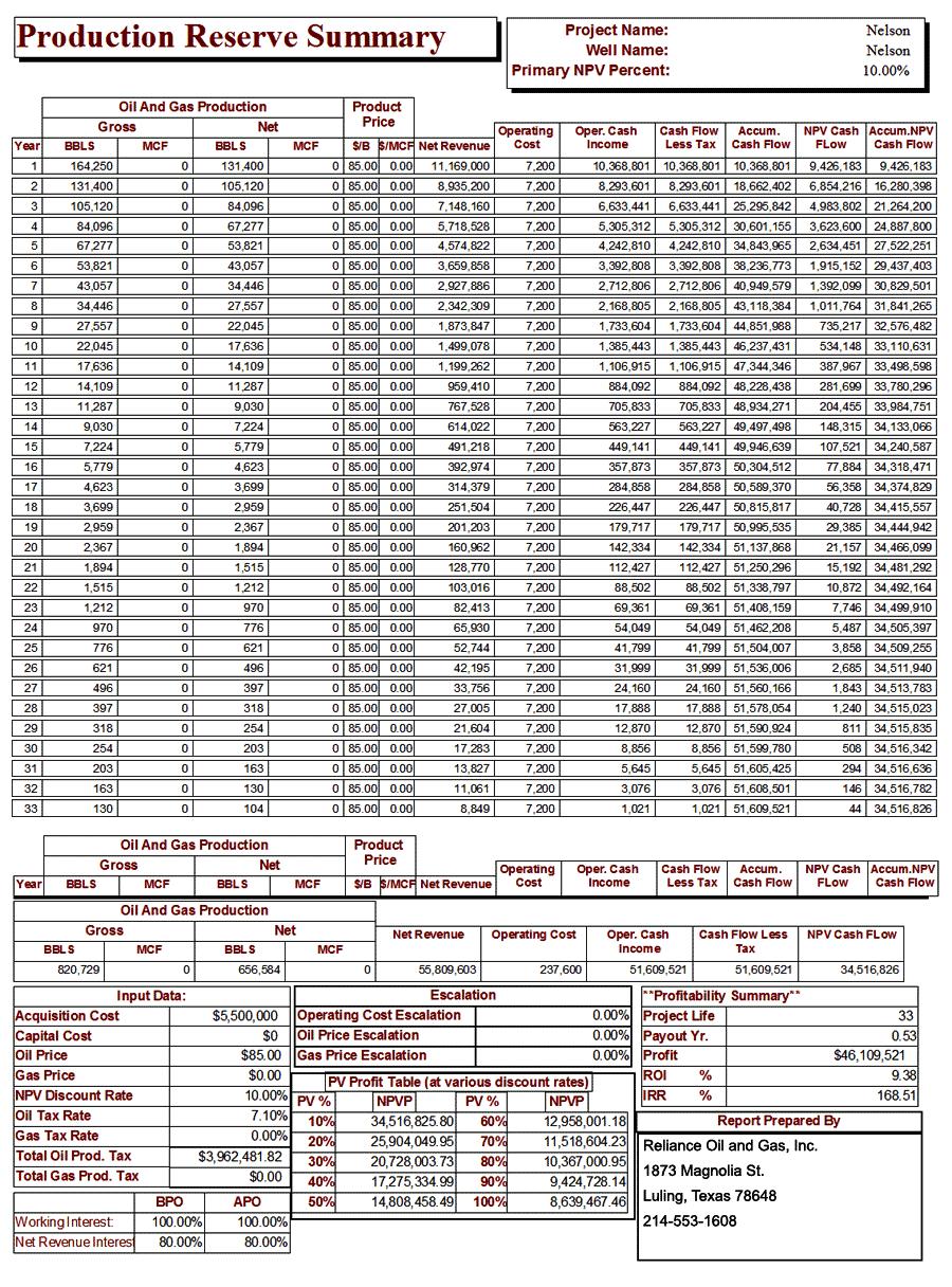
- Kory Nelson
- 6 years ago
- Views:
Transcription
1
2 N O V A R E S O U R C E, I N C. CERTIFIED PETROLEUM GEOLOGISTS REGISTERED PROFESSIONAL ENGINEERS CERTIFIED PETROLEUM GEOPHYSICISTS P. O. Box Dallas, Texas Tel/Fax(972) novapet@tx.rr.net page 1 of 10 Mr. Joseph Damato Reliance Oil & Gas, Inc FM 466 Seguin, Texas (214) ; Fax 1609 joe@relianceoil.com RE: Reliance Oil & Gas, Inc. s Nelson Lease of Guadalupe Co, Tx Recoverable Reserves and Economic Analysis Re: Nelson Oil & Gas Lease of Abstract A-25 Guadalupe County, Texas Mr. Damato, As per your request, using your supplied data, and under your authorization, Nova Resource, Inc. has analyzed the data supplied by the operator and updated by Nova to determine the remaining recoverable oil and gas reserves from the owned and operated oil and gas lease located in the northeastern portion of Guadalupe Co., Tx and otherwise known as the Nelson lease of the Samuel Highsmith League Abstract # 25 located between Darst Creek oil field and Dunlap oil field approximately 6 miles southwest of the town of Luling Texas. Adjacent developed fields also include Bob Rose, Luling W., and the Luling-Branyon fields. A detailed analysis of the interests in the referenced lease was performed using the lease plat and other data supplied by the operator, data from the Railroad Commission of Texas, and selected records from commercial and private data sources. Detailed audits of the data supplied by the operator were not performed. The referenced lease s recoverable oil and gas reserves potential was analyzed by applying standard industry analytical procedures and criteria to derive the reserves evaluation and valuation as stated in this report.
3 Nova/Reliance: RE: Reliance Oil & Gas, Inc. s Nelson Lease of Guadalupe Co, TX page 2 of 10 The available data indicate that 4 wellbores exist on the Nelson lease with three (3) being productive and one (1) reported dry hole. The lease consists of one contiguous unit of approximately +/- 80 acres running in a northeast to southwest direction south of US Highway 90 approximately 6 miles southwest of the town of Luling Texas. The lease has eight (8) in-fill and two (2) stepout drilling locations for a total of 10 well locations remaining to be drilled. This report refers only to existing producing wells and to the ten (10) well remaining locations. The referenced Nelson lease is productive for oil and/or gas and/or water from several Cretaceous age formations. Productive formations from the surrounding fields include the Updip Austin Chalk, the Edwards Lime, and/or the Navarro formations. The Austin Chalk is considered the primary reservoir with the Edwards and Navarro being secondary reservoirs. Three distinct shallow hydrocarbon producing reservoir plays exist in the area of Guadalupe County and are identified as the, 1) Lower Cretaceous Shelf Carbonate Fault Zone Oil Play; 2) the Buda Fault Zone Oil Play; and 3) the Austin Chalk play. Deeper reservoirs no doubt exist in the area, however, few wells have been drilled to the lower horizons. Recent Activity in the Vicinity of the Nelson Lease: Recently reported drilling has occurred on nearby leases using conventional and horizontal drilling. These nearby newly drilled wells are reported by the operator of the Nelson lease to have resulted in the completion of oil wells from the Austin Chalk formation with initial potential productions of up to 200 Barrels of oil per day per well with an average potential of 51 barrels of oil per day per well. The operator states that it believes that it can substantially increase oil production by the use of Horizontal Radial Fracturing on the projected wells in anticipation of creating fractures in the reservoir which radiate outward from the wellbore in a circumference approximately 60 to 80 feet.
4 Nova/Reliance: RE: Reliance Oil & Gas, Inc. s Nelson Lease of Guadalupe Co, TX page 3 of 10 REGIONAL PLAYS GEOLOGIC DESCRIPTIONS Play Number 1 (Lower Cretaceous Shelf Carbonate Reservoirs): The Lower Cretaceous age shelf carbonate formation plays consists of carbonates of the Edwards, Georgetown, and Glen Rose formations that produce oil from structural traps along regional fault zones. The downdip boundary of the play follows the edges of the Luling, Charlotte, and Mexia fault zones, and the updip boundary is the Balcones Fault Zone. Reservoirs of the play are extensively dolomitized restricted-platform and tidal-flat carbonates. Reservoir porosity was created by dolomitization and subsequent diagenetic de-dolomitization, collapse breccias formed by removal of tidal-flat evaporates, and moldic porosity after leaching of bioclastic fragments. Depths range from 1,000 to 5,000 feet. Source rocks are the Lower Cretaceous marine shelf and slope organic-rich mudstones. The Lower Cretaceous reservoirs are sealed by down-faulted, less permeable Upper Cretaceous carbonates and mudstones with many reservoirs located on paleo-highs along the San Marcos Arch. The reservoirs in this play are typified by the Luling-Branyon, Darst Creek, and Salt Flat Field pays. Play Number 2 (Buda Fault Zone Reservoirs): The Buda Fault Zone Oil Play is defined by Upper Cretaceous Buda Formation chalk reservoirs that produce oil from structural traps along peripheral fault zones. The updip boundary of the play is the Balcones Fault Zone, and the down dip boundary is the Luling and Charlotte Fault Zones. Reservoirs in this play are coccolith- and foraminifer-bearing micrites. Fracturing is required in the chalk for the rock to be a reservoir. Fracturing is present in the Buda near fault zones. Depths to the Buda range from 1,000 to 6,000 feet. Source rocks for the Buda are considered to be mudstones within the Buda and the overlying Eagleford formation, which, by juxtaposition with fractured Buda in the fault zones, allows for migration into the Buda from the Eagleford. The Buda produces from structurally high positions along the fault zones.
5 Nova/Reliance: RE: Reliance Oil & Gas, Inc. s Nelson Lease of Guadalupe Co, TX page 4 of 10 Play Number 3 (Austin Updip Oil Reservoirs): The Austin Updip Oil play is defined by Upper Cretaceous Austin carbonate reservoirs that produce oil from structural traps along fault zones with associated fracturing. The boundaries of the play are the limits of the Balcones, Mexia, Luling, and Charlotte fault zones. Reservoirs are, as in the Buda formation play, coccolith- and foraminifer-bearing micrites or chalks of the Austin formation. The chalk must be fractured for an economic reservoir to be present. Minor reservoirs in this play are limestones of the Upper Cretaceous Dale and Anacacho Formations. Depths of undiscovered reservoirs range from 1,000 to 4,000 feet. Source rocks are considered to be the organic-rich micrites within the Austin and the mudstones of the underlying Eagleford Formation. Traps are related to the fault zones including the Mexia, Luling, Charlotte, and Balcones segments. Faulting has brought the fractured Austin, Dale, and Anacacho limestone into structurally high positions relative to the less porous Upper Cretaceous. LEASE PRIMARY OBJECTIVE DESCRIPTION Primary Target Pay Formation (Austin Chalk): The Austin Chalk is a known productive formation and is productive in fields surrounding your referenced Guadalupe County, Texas Nelson lease.
6 Nova/Reliance: RE: Reliance Oil & Gas, Inc. s Nelson Lease of Guadalupe Co, TX page 5 of 10 Austin Chalk Formation: Drilling, Completion and History: There have been multiple stages of exploration and development in the Austin Chalk since the first wells were drilled in the 1920 s. Conventional drilling with vertical wells established many commercially successful oil wells. Fractures are required to be present to establish commercial production of oil from the Austin Chalk. The Austin Chalk reservoir is a tight, fine-grained, fossiliferious, fractured carbonate interbedded with shales and marls that were deposited in a quiet open marine environment during a period of marine transgression. The main productive chalk trend lies at a depth of 500 to 8,000 feet. The thickness of the Austin Chalk ranges from 35 to 500 feet with specific targets within that interval. Variable lateral reservoir characteristics exist throughout the trend resulting in a wide range of production profiles. As a consequence, operators have drilled horizontal wells in areas of known production in order to encounter as many vertically fractured zones as possible in order to expose as much of the productive fractured Austin Chalk as possible to the wellbore. In most areas of the Austin Chalk, horizontal legs have been drilled to the Northeast or to the Southwest in order to encounter the greatest number of fractures. The operator plans to use less expensive and as effective Horizontal Radial Fracturing to complete the wells. Wells drilled to the Southeast or Northwest typically encounter fewer numbers of faults but these horizontal legs follow along larger faults and can produce high initial volumes of oil as well. A successful horizontal well drilled in the Austin Chalk can expect 50 to 200 barrel of oil per day initial potential. This initial productive potential allows for the rapid payout of the cost of drilling the horizontal well. The reservoirs daily production declines very rapidly due to depletion of the fracture fluid pressure and collapse of the fractures with subsequent restriction of the flow of oil through the fractures to the wellbores. A sustained lower rate of oil production can be expected from these fractured reservoirs after the initial high rate of production declines. The rapid payout of the drilling cost has sustained the drilling interests in the Austin Chalk reservoirs. With today s price of oil in the range of $ 90 per barrel of oil, the Austin Chalk is once again being drilled in the many locations remaining to be developed.
7 Nova/Reliance: RE: Reliance Oil & Gas, Inc. s Nelson Lease of Guadalupe Co, TX page 6 of 10 Accurate production records on a well by well basis are not available for typical Austin Chalk leases drilled. Since Texas allows production to be reported by lease and not by well, a lease with multiple wells drilled and producing may have large cumulative production but it is unknown as to how much oil or gas was produced from any one well unless the operator metered each well. Techniques have been developed to estimate the recoverable oil or gas reserves from such leases but only a metered well record will definitively reveal how much oil or gas has been recovered from any one well. For this reason only the operator s reported averages have been used in this report and records from the surrounding lease production records to project the recoverable reserves from the referenced Nelson lease of Guadalupe County, Texas using the new completion and production techniques reported applicable by the operator. The operator has informed Nova that they intend to enter into an agreement whereby the investor and the operator shall split all costs and production and revenue on a 50/50 basis to the drill, test, and complete, if warranted, ten (10) wells on the referenced Nelson lease. Reliance Oil & Gas, Inc. has reported that 100% of the costs associated with each wells drilling and completion will be at $ 550,000 USD which includes, all land, geology, engineering and contingency costs. The lease has an 80% Net Revenue Interest and a 100% Working Interest. The Operator, Reliance Oil and Gas, Inc. shall be responsible for payment of 50% Working Interests Costs and shall receive 40% NRI in the wells and lease and production and revenue and the investors shall be responsible for payment of 50% Working Interests costs ans shall receive 40% NRI in the wells and lease and production and revenue. All prices of oil at $ 85 per barrel and well operating costs in Nova s evaluations are held constant. An oil severance tax of 7.1 % and an ad valorum tax of 2% of the net revenue are used. A salvage value of 2 % is included in the analysis. A decline rate of 20 % is used in this analysis. The operator reports that water disposal is available. Therefore the operator reports that the projected Lease Operating Expense will be no more than $ 7,200 per well per year on average. Initial production rates from new wells may vary from 50 barrels to 200 barrels of oil per well per day with an average initial production rate of 50 Barrels of oil per day used in the analysis and anticipated from any successful well.
8 Nova/Reliance: RE: Reliance Oil & Gas, Inc. s Nelson Lease of Guadalupe Co, TX page 7 of 10 RESERVES AND ECONOMIC ANALYSIS Nova performed a through analysis of the leases described by the operator for the regional reservoirs and also used public and private data and proprietary data sources to complete the analysis. The following is a summary of the ten (10) wells to be drilled anticipated recoverable reserves from your interests in the referenced Nelson Lease of Guadalupe County, Texas. Production does exist from the lease and also from the surrounding leases from the Austin Chalk formation. Production from any new successfully drilled and completed wells upon the lease is expected to be from the Austin Chalk and possibly from the Lower Cretaceous or Buda formations and is anticipated to be from a depth between 2,000 and 3,000 feet. The original lease NRI and LOE used are 80 % and $ 7,200 per well per year respectively with Reliance paying for its 50% working interests and the Investors pay for their 50% working interests (a total of 100% working Interests Expenses at $ 550,000 USD per well) and both Reliance and the investors each receiving 50% of 80% NRI or 40% NRI each of all of the production and revenue from the wells and lease with the land owner retaining a 20% royalty in all of the production and revenue from the wells and lease. Drilling of a horizontal radial frac well location is projected to produce an average Initial Potential Calculated Absolute Open Flow Rate of 50 Barrels of oil per day per well. Nova has used an exponential decline rate of 20% for the projected initial production rates. Initial Potential of any well may be zero, lower, or higher than projected, and declines rates may be lower or higher than projected. Due to the fractured nature of the Austin Chalk, the primary objective reservoir, spacing of the wellbores can be high or low with 2.0 acres per well being typical for other developed fields. This report uses a spacing of 2.0 acres per remaining well location for the ten (10) well development valuation.
9 Nova/Reliance: RE: Reliance Oil & Gas, Inc. s Nelson Lease of Guadalupe Co, TX page 8 of 10 Pipelines and gatherers in the area include Luling Gas Gathering, Casa Pipeline System, Oasis Pipeline System 3900, and PLAML, TEPPO Crude Oil, CONPH, GULFM (Gulfmark Energy), ELPAF (El Paso Field Services), etc. Using the operator supplied data and other sources of data the following oil reserves volumes can reasonably be expected to be in place from ten (10) successful wells to be drilled using conventional analytical techniques from wells drilled in optimum locations upon the lease. ECONOMICS AND RESERVES SUMMARY TEN WELLS ANALYSIS On a ten (10) well basis: ten (10) wells development at 50 BOPD per well: To 100% Working Interest on a successful basis as projected: Capital Investment: $ 5,500,000 USD Ultimate oil recovery: Net recoverable oil: 813,039 Bbls 650,431 Bbls Net Income/Investment Ratio: 8.84:1 Net Present PV- 0% Discount: $ 43,099,544 USD Net Present PV-10% Discount: $ 29,153,372 USD
10 Nova/Reliance: RE: Reliance Oil & Gas, Inc. s Nelson Lease of Guadalupe Co, TX page 9 of 10 A three page recoverable reserves and production/cash flow projection analysis for ten wells to be drilled is attached. A sensitivity analysis projection is also included for the ten (10) well locations oil recovery from your planned drilling project. The sensitivity analysis uses projections from zero barrels of oil recovery initial rates per well per day for each of the eight wells to 75 barrels of oil recovery initial rates per well per day for each of the ten wells to be drilled and uses exponential decline rates from 20% to 50% to calculate 16 possible recovery rates and recoverable reserves values for this project. All oil and gas ventures involve risk of loss of part or all of any investment. This analysis does not include risk analysis. Nova does not guarantee, warrant, express or imply, by inclusion or omission, the presence of all or any hydrocarbons, either oil or natural gas, based upon data supplied by any operator. Nova has accepted the operator s supplied data as accurate without audit. Anyone considering investing in or attempting to recover oil and gas from any oil and gas well or project should seek their own independent third party outside council and advise before investing in any oil and gas venture. Nova is acting as an independent consulting geological, geophysical, and engineering firm retained by the operator to perform this analysis. Nova does not have or retain any interests in the referenced or adjacent leases.
11 Nova/Reliance: RE: Reliance Oil & Gas, Inc. s Nelson Lease of Guadalupe Co, TX page 10 of 10 If you have any questions please feel free to call Nova Resource, Inc. at (972) or contact Nova by at novapet@tx.rr.com. Thank you for this opportunity to be of service to you and your company. Respectfully, Nova Resource, Inc. J. V. Rochefort President Encl: Recoverable Reserves Calculations Ten (10) wells recoverable three-page reserves analysis; one page sensitivity analysis; Lease and Well Maps and Data Nelson Lease Report & Invoice Damato Reliance Nelson Lease of Guadalupe Co., TX Recoverable Reserves Rpt & Invoice
12
13
14 N O V A R E S O U R C E, I N C. CERTIFIED PETROLEUM GEOLOGISTS REGISTERED PROFESSIONAL ENGINEERS CERTIFIED PETROLEUM GEOPHYSICISTS P. O. Box Dallas, Texas Tel/Fax(972) novapet@tx.rr.net page 1 of 10 Mr. Joseph Damato Reliance Oil & Gas, Inc FM 466 Seguin, Texas (214) ; Fax 1609 joe@relianceoil.com RE: Reliance Oil & Gas, Inc. s Perfetto Lease of Guadalupe Co, Tx Recoverable Reserves and Economic Analysis Re: Perfetto Oil & Gas Lease of Abstract A-25 Guadalupe County, Texas Mr. Damato, As per your request, using your supplied data, and under your authorization, Nova Resource, Inc. has analyzed the data supplied by the operator and updated by Nova to determine the remaining recoverable oil and gas reserves from the owned and operated oil and gas lease located in the northeastern portion of Guadalupe Co., Tx and otherwise known as the Perfetto lease of the Samuel Highsmith League Abstract # 25 located between Darst Creek oil field and Dunlap oil field approximately 6 miles southwest of the town of Luling Texas. Adjacent developed fields also include Bob Rose, Luling W., and the Luling-Branyon fields. A detailed analysis of the interests in the referenced lease was performed using the lease plat and other data supplied by the operator, data from the Railroad Commission of Texas, and selected records from commercial and private data sources. Detailed audits of the data supplied by the operator were not performed. The referenced lease s oil and gas reserves potential was analyzed by applying standard industry analytical procedures and criteria to derive the reserves evaluation and valuation as stated in this report.
15 Nova/Reliance: RE: Reliance Oil & Gas, Inc. s Perfetto Lease of Guadalupe Co, TX page 2 of 10 The available data indicate that 5 wellbores exist on the Perfetto lease with three (3) being productive, one (1) abandoned productive well, and one (1) reported dry hole. The lease consists of one contiguous unit of approximately +/- 57 acres running in a northeast to southwest direction south of US Highway 90 approximately 6 miles southwest of the town of Luling Texas. The lease has seven (7) infill drilling locations and 3 probable and 2 possible drilling locations remaining with a full development project yielding an additional 3 probable locations remaining with a total of 12 well locations remaining to be drilled. This report refers only to existing producing wells and to the ten (10) infill and probable well locations. The referenced Perfetto lease is productive for oil and/or gas and/or water from several Cretaceous age formations. Productive formations from the surrounding fields include the Updip Austin Chalk, the Edwards Lime, and/or the Navarro formations. The Austin Chalk is considered the primary reservoir with the Edwards and Navarro being secondary reservoirs. Three distinct shallow hydrocarbon producing reservoir plays exist in the area of Guadalupe County and are identified as the, 1) Lower Cretaceous Shelf Carbonate Fault Zone Oil Play; 2) the Buda Fault Zone Oil Play; and 3) the Austin Chalk play. Deeper reservoirs no doubt exist in the area, however, few wells have been drilled to the lower horizons. Recent Activity in the Vicinity of the Perfetto Lease: Recently reported drilling has occurred on nearby leases using conventional and horizontal drilling. These nearby newly drilled wells are reported by the operator of the Perfetto lease to have resulted in the completion of oil wells from the Austin Chalk formation with initial potential productions of up to 200 Barrels of oil per day per well with an average potential of 51 barrels of oil per day per well. The operator has stated that it plans to increase the rate of production from the anticipated wells to be drilled by the use of Horizontal Radial Fracturing which creates fractures in a circumference around the wellbore out into the pay zone approximately 60 to 80 feet.
16 Nova/Reliance: RE: Reliance Oil & Gas, Inc. s Perfetto Lease of Guadalupe Co, TX page 3 of 10 REGIONAL PLAYS GEOLOGIC DESCRIPTIONS Play Number 1 (Lower Cretaceous Shelf Carbonate Reservoirs): The Lower Cretaceous age shelf carbonate formation plays consists of carbonates of the Edwards, Georgetown, and Glen Rose formations that produce oil from structural traps along regional fault zones. The downdip boundary of the play follows the edges of the Luling, Charlotte, and Mexia fault zones, and the updip boundary is the Balcones Fault Zone. Reservoirs of the play are extensively dolomitized restricted-platform and tidal-flat carbonates. Reservoir porosity was created by dolomitization and subsequent diagenetic de-dolomitization, collapse breccias formed by removal of tidal-flat evaporates, and moldic porosity after leaching of bioclastic fragments. Depths range from 1,000 to 5,000 feet. Source rocks are the Lower Cretaceous marine shelf and slope organic-rich mudstones. The Lower Cretaceous reservoirs are sealed by down-faulted, less permeable Upper Cretaceous carbonates and mudstones with many reservoirs located on paleo-highs along the San Marcos Arch. The reservoirs in this play are typified by the Luling-Branyon, Darst Creek, and Salt Flat Field pays. Play Number 2 (Buda Fault Zone Reservoirs): The Buda Fault Zone Oil Play is defined by Upper Cretaceous Buda Formation chalk reservoirs that produce oil from structural traps along peripheral fault zones. The updip boundary of the play is the Balcones Fault Zone, and the down dip boundary is the Luling and Charlotte Fault Zones. Reservoirs in this play are coccolith- and foraminifer-bearing micrites. Fracturing is required in the chalk for the rock to be a reservoir. Fracturing is present in the Buda near fault zones. Depths to the Buda range from 1,000 to 6,000 feet. Source rocks for the Buda are considered to be mudstones within the Buda and the overlying Eagleford formation, which, by juxtaposition with fractured Buda in the fault zones, allows for migration into the Buda from the Eagleford. The Buda produces from structurally high positions along the fault zones.
17 Nova/Reliance: RE: Reliance Oil & Gas, Inc. s Perfetto Lease of Guadalupe Co, TX page 4 of 10 Play Number 3 (Austin Updip Oil Reservoirs): The Austin Updip Oil play is defined by Upper Cretaceous Austin carbonate reservoirs that produce oil from structural traps along fault zones with associated fracturing. The boundaries of the play are the limits of the Balcones, Mexia, Luling, and Charlotte fault zones. Reservoirs are, as in the Buda formation play, coccolith- and foraminifer-bearing micrites or chalks of the Austin formation. The chalk must be fractured for an economic reservoir to be present. Minor reservoirs in this play are limestones of the Upper Cretaceous Dale and Anacacho Formations. Depths of undiscovered reservoirs range from 1,000 to 4,000 feet. Source rocks are considered to be the organic-rich micrites within the Austin and the mudstones of the underlying Eagleford Formation. Traps are related to the fault zones including the Mexia, Luling, Charlotte, and Balcones segments. Faulting has brought the fractured Austin, Dale, and Anacacho limestone into structurally high positions relative to the less porous Upper Cretaceous. LEASE PRIMARY OBJECTIVE DESCRIPTION Primary Target Pay Formation (Austin Chalk): The Austin Chalk is a known productive formation and is productive in fields surrounding your referenced Guadalupe County, Texas Perfetto lease.
18 Nova/Reliance: RE: Reliance Oil & Gas, Inc. s Perfetto Lease of Guadalupe Co, TX page 5 of 10 Austin Chalk Formation: Drilling, Completion and History: There have been multiple stages of exploration and development in the Austin Chalk since the first wells were drilled in the 1920 s. Conventional drilling with vertical wells established many commercially successful oil wells. Fractures are required to be present to establish commercial production of oil from the Austin Chalk. The Austin Chalk reservoir is a tight, fine-grained, fossiliferious, fractured carbonate interbedded with shales and marls that were deposited in a quiet open marine environment during a period of marine transgression. The main productive chalk trend lies at a depth of 500 to 8,000 feet. The thickness of the Austin Chalk ranges from 35 to 500 feet with specific targets within that interval. Variable lateral reservoir characteristics exist throughout the trend resulting in a wide range of production profiles. As a consequence, operators have drilled horizontal wells in areas of known production in order to encounter as many vertically fractured zones as possible in order to expose as much of the productive fractured Austin Chalk as possible to the wellbore. The Operator plans to use less expensive and just as effective Horizontal Radial Fracturing to complete the wells. In most areas of the Austin Chalk, horizontal legs have been drilled to the Northeast or to the Southwest in order to encounter the greatest number of fractures. Wells drilled to the Southeast or Northwest typically encounter fewer numbers of faults but these horizontal legs follow along larger faults and can produce high initial volumes of oil as well. A successful horizontal well drilled in the Austin Chalk can expect 50 to 200 barrel of oil per day initial potential. This initial productive potential allows for the rapid payout of the cost of drilling the horizontal well. The reservoirs daily production declines very rapidly due to depletion of the fracture fluid pressure and collapse of the fractures with subsequent restriction of the flow of oil through the fractures to the wellbores. A sustained lower rate of oil production can be expected from these fractured reservoirs after the initial high rate of production declines. The rapid payout of the drilling cost has sustained the drilling interests in the Austin Chalk reservoirs. With today s price of oil in the range of $ 90 per barrel of oil, the Austin Chalk is once again being drilled in the many locations remaining to be developed.
19 Nova/Reliance: RE: Reliance Oil & Gas, Inc. s Perfetto Lease of Guadalupe Co, TX page 6 of 10 Accurate production records on a well by well basis are not available for typical Austin Chalk leases drilled. Since Texas allows production to be reported by lease and not by well, a lease with multiple wells drilled and producing may have large cumulative production but it is unknown as to how much oil or gas was produced from any one well unless the operator metered each well. Techniques have been developed to estimate the recoverable oil or gas reserves from such leases but only a metered well record will definitively reveal how much oil or gas has been recovered from any one well. For this reason only the operator s reported averages have been used in this report and records from the surrounding lease production records to project the recoverable reserves from the referenced Perfetto lease of Guadalupe County, Texas using the new completion and production techniques reported applicable by the operator. The operator has informed Nova that they intend to turnkey the operations to drill, test, and complete, if warranted, ten (10) wells on the referenced Perfetto lease. Reliance Oil & Gas, Inc. has reported that costs associated with each wells drilling and completion will be at a cost of $ 550,000 USD per well which includes all land, geology, engineering and contingency costs. The lease has an 80% Net Revenue Interest and a 100% Working Interest. The Operator, Reliance Oil and Gas, Inc. shall retain 50% Working Interests and pay its respective Working Interests costs and receive 50% of the 80% NRI Lease interest or 40% NRI interests in the wells and leases and production and revenue to be produced and the investors shall retain 50% Working Interests and pay their respective Working Interests costs and receive 50% of the 80% NRI Lease interest or 40% NRI interests in the wells and leases and production and revenue to be produced. All prices of oil at $ 85 per barrel and well operating costs in Nova s evaluations are held constant. An oil severance tax of 7.1 % and an ad valorum tax of 2% of the net revenue are used. A salvage value of 2 % is included in the analysis. A decline rate of 20 % is used in this analysis. The operator reports that water disposal is available. Therefore the operator reports that the projected Lease Operating Expense will be no more than $ 7,200 per well per year on average. Initial production rates from new wells may vary from 50 barrels to 200 barrels of oil per well per day with an average initial production rate of 50 Barrels of oil per day used in the analysis and anticipated from any successful well.
20 Nova/Reliance: RE: Reliance Oil & Gas, Inc. s Perfetto Lease of Guadalupe Co, TX page 7 of 10 RESERVES AND ECONOMIC ANALYSIS Nova performed a through analysis of the leases described by the operator for the regional reservoirs and also used public and private data and proprietary data sources to complete the analysis. The following is a summary of the ten (10) anticipated wells recoverable reserves from your interests in the referenced Perfetto Lease of Guadalupe County, Texas. Production does exist from the lease and also from the surrounding leases from the Austin Chalk formation. Production from any new successfully drilled and completed wells upon the lease is expected to be from the Austin Chalk and possibly from the Lower Cretaceous or Buda formations and is anticipated to be from a depth between 2,000 and 3,000 feet. The original lease NRI and LOE used are 80 % and $ 7,200 per well per year. Reliance is to retain a 50% working interests and receive a 40% NRI interests and the investors are to retain a 50% working interests and receive a 40% NRI interests in the wells, leases, production and revenue. The land owner is to retain a 20% royalty in all of the production and revenue from the wells and lease. Drilling of a horizontal radial frac well location is projected to produce an average Initial Potential Calculated Absolute Open Flow Rate of 50 Barrels of oil per day per well. Nova has used an exponential decline rate of 20% for the projected initial production rates. Initial Potential of any well may be zero, lower, or higher than projected, and declines rates may be lower or higher than projected. Due to the fractured nature of the Austin Chalk, the primary objective reservoir, spacing of the wellbores can be high or low with 2.0 acres per well being typical for other developed fields. This report uses a spacing of 2.0 acres per remaining well location for the ten (10) wells development project.
21 Nova/Reliance: RE: Reliance Oil & Gas, Inc. s Perfetto Lease of Guadalupe Co, TX page 8 of 10 Pipelines and gatherers in the area include Luling Gas Gathering, Casa Pipeline System, Oasis Pipeline System 3900, and PLAML, TEPPO Crude Oil, CONPH, GULFM (Gulfmark Energy), ELPAF (El Paso Field Services), etc. Using the operator supplied data and other sources of data the following oil reserves volumes can reasonably be expected to be in place from ten (10) successful wells to be drilled using conventional analytical techniques from wells drilled in optimum locations upon the lease. ECONOMICS AND RESERVES SUMMARY TEN WELLS ANALYSIS On a ten (10) wells basis: ten (10) wells development at 50 BOPD per well: To 100% Working Interests on a successful basis as projected: Capital Investment: $ 5,500,000 USD Ultimate recoverable oil: 813,039 Bbls Net recoverable oil: 650,431 Bbls Net Income/Investment ratio: 8.84:1 Net Present PV- 0% Discount: $ 43,099,544 USD Net Present PV-10% Discount: $ 29,153,372 USD
22 Nova/Reliance: RE: Reliance Oil & Gas, Inc. s Perfetto Lease of Guadalupe Co, TX page 9 of 10 A three page recoverable reserves and production/cash flow projection analysis for ten (10) wells is attached. A sensitivity analysis projection is included for ten (10) well locations oil recovery from your planned drilling project. The sensitivity analysis uses projections from zero barrels of oil recovery initial rates per well per day for each of the eight wells to 75 barrels of oil recovery initial rates per well per day for each of the ten wells to be drilled and uses exponential decline rates from 20% to 50% to calculate 16 possible recovery rates and recoverable reserves values for this project. All oil and gas ventures involve risk of loss of part or all of any investment. This analysis does not include risk analysis. Nova does not guarantee, warrant, express or imply, by inclusion or omission, the presence of all or any hydrocarbons, either oil or natural gas, based upon data supplied by any operator. Nova has accepted the operator s supplied data as accurate without audit. Anyone considering investing in or attempting to recover oil and gas from any oil and gas well or project should seek their own independent third party outside council and advise before investing in any oil and gas venture. Nova is acting as an independent consulting geological, geophysical, and engineering firm retained by the operator to perform this analysis. Nova does not have or retain any interests in the referenced or adjacent leases.
23 Nova/Reliance: RE: Reliance Oil & Gas, Inc. s Perfetto Lease of Guadalupe Co, TX page 10 of 10 If you have any questions please feel free to call Nova Resource, Inc. at (972) or contact Nova by at novapet@tx.rr.com. Thank you for this opportunity to be of service to you and your company. Respectfully, Nova Resource, Inc. J. V. Rochefort President Encl: Recoverable Reserves Calculations Ten (10) wells recoverable three-page reserves analysis; one page sensitivity analysis; Lease and Well Maps and Data Perfetto Lease Report & Invoice Damato Reliance Perfetto Lease of Guadalupe Co., TX Recoverable Reserves Rpt & Invoice
24
WEJCO. Exploration & Production. Eagle s Talon Prospect. The Eagle s Talon Prospect is located in south eastern Karnes County,
 WEJCO Exploration & Production Eagle s Talon Prospect The Eagle s Talon Prospect is located in south eastern Karnes County, Texas, within the new and highly prolific unconventional Eagle Ford Shale trend
For personal use only
 Date: 18 February 2019 ASX Code: WEL Directors John Kopcheff Non-Executive Chairman Neville Henry Managing Director Peter Allchurch Non-Executive Director James Hodges Non-Executive Director Larry Liu
Testing of the Strawn Sand, White Hat 20#3, Mustang Prospect, Permian Basin, Texas
 Date: 11 April 2019 ASX Code: WEL Directors John Kopcheff Non-Executive Chairman Neville Henry Managing Director Peter Allchurch Non-Executive Director Larry Liu Non-Executive Director Lloyd Flint Company
Update - Testing of the Strawn Sand, White Hat 20#3, Mustang Prospect, Permian Basin, Texas
 Date: 15 April 2019 ASX Code: WEL Directors John Kopcheff Non-Executive Chairman Neville Henry Managing Director Peter Allchurch Non-Executive Director Larry Liu Non-Executive Director Lloyd Flint Company
Working Interest Kris Kon #2-Project Deal
 Working Interest Kris Kon #2-Project Deal Page 1 of 10 Kris Kon #2-Project Deal October 2016 Project provider Project name Geographical area Formation/Primary targets Type of wells Number of wells Expected
APPENDIX C GEOLOGICAL CHANCE OF SUCCESS RYDER SCOTT COMPANY PETROLEUM CONSULTANTS
 APPENDIX C GEOLOGICAL CHANCE OF SUCCESS Page 2 The Geological Chance of Success is intended to evaluate the probability that a functioning petroleum system is in place for each prospective reservoir. The
RAILROAD CoMMIssIoN OF TEXAS
 HEARINGS DIVISION RAILROAD CoMMIssIoN OF TEXAS RYAN SITTON, COMMISSIONER WAYNE CHRISTIAN, COMMISSIONER APPEARANCES: RECORD CLOSED: CONFERENCE DATE: HEARING DATE: Jennifer Cook HEARD BY: Karl CaIdwell CHRISTI
Unconventional Natural Gas A Brief Review for Instituto Petroquimica Argentina
 October 5, 2010 Unconventional Natural Gas A Brief Review for Instituto Petroquimica Argentina William L. Tittle Principal and Director of Strategy Americas and Asia Raul Arias Alvarez Senior Consultant
Drilling Info Open To Explore. Eagle Ford Shale Overview Ramona Hovey, SVP Analysis and Consulting February 23, 2011
 Drilling Info Open To Explore Eagle Ford Shale Overview Ramona Hovey, SVP Analysis and Consulting February 23, 2011 EAGLE FORD SHALE OVERVIEW 2 Eagle Ford History Geologists have known about Eagle Ford
Article 11 Monte Carlo Simulation/Risk Assessment (cont.)
") RESE SERVOIR ENG NGINE INEERING FOR GEOLO OLOGIS ISTS Article 11 Monte Carlo Simulation/Risk Assessment (cont.) by Ray Mireault, P. Eng. and Lisa Dean, P. Geol., Fekete Associates Inc. The second article
RESE SERVOIR ENG NGINE INEERING FOR GEOLO OLOGIS ISTS Article 11 Monte Carlo Simulation/Risk Assessment (cont.) by Ray Mireault, P. Eng. and Lisa Dean, P. Geol., Fekete Associates Inc. The second article
For personal use only
 28 May 2012 Farm Out Arrangements Turner Bayou Project Pryme Energy Limited (Pryme) and its partners in the Turner Bayou project have established arrangements for farming out of a portion of their project
BLACK PLATINUM ENERGY LTD
 Black Platinum Energy Ltd ( BPE or the Company ) Announces a Material Increase in the Discovered Dara East Gas Field Resources and Upside Potential Resources in Nearby Features Dara East Assessed Gas Resource
Masila 1: Shallow shelf carbonate facies variability and secondary reservoir development - Saar Formation Masila block, Yemen
 Masila 1: Shallow shelf carbonate facies variability and secondary reservoir development - Saar Formation Masila block, Yemen Kent Wilkinson* Nexen Inc., Calgary, AB kent_wilkinson@nexeninc.com ABSTRACT
4. Carboniferous Zone Play Results
 C H A P T E R F O U R 4. Carboniferous Zone Play Results 4. Geological Overview In the WCSB, there were two main depositional areas during Carboniferous time the Peace River Embayment in northwestern Alberta,
An Analytic Approach to Sweetspot Mapping in the Eagle Ford Unconventional Play
 An Analytic Approach to Sweetspot Mapping in the Eagle Ford Unconventional Play Murray Roth*, Transform Software and Services, Denver, Colorado, Murray@transformsw.com Michael Roth, Transform Software
Tim Carr - West Virginia University
 Tim Carr - West Virginia University Role of Geology in Field Development Develop static geological model of the reservoir(s) Analyze relevant geoscience and engineering data, integrate them into model
For personal use only
 Listed on the Australian Securities Exchange ( AKK ) and the OTC-QX International in the USA (AUN-XY) ACN 114 198 471 ASX ANNOUNCEMENT 1 May 2014 Drilling operations underway for 1 st Pierre oil well in
AAPG HEDBERG RESEARCH CONFERENCE
 AAPG HEDBERG RESEARCH CONFERENCE Reservoir Scale Deformation - Characterization and Prediction June 22-28, 1997, Bryce, Utah Stratigraphic Controls on Fracture Distribution in the Austin Chalk: An Example
Pershing Gold Extends High-Grade Mineralization through Step-Out Drilling in Phase 1 and Initiates Phase 2 Drilling Program
 Pershing Gold Extends High-Grade Mineralization through Step-Out Drilling in Phase 1 and Initiates Phase 2 Drilling Program LAKEWOOD, Colo., November 9, 2016 (PR NEWSWIRE) Pershing Gold Corporation (NASDAQ:PGLC)
Tim Carr - West Virginia University
 Tim Carr - West Virginia University Elements Source Rock Migration Route Reservoir Rock Seal Rock Trap Processes Generation Migration Accumulation Preservation 2 Reservoir Porous & Permeable Rock Suitable
2018 Prospect Inventory in South Texas 13 Conventional Prospects
 Thunder Rock Exploration, Inc. P.O. Box 769 Fulshear, Texas 77441-0769 (281) 533-9440 Office (281) 685-3047 Mobile jgkane@hal-pc.org jgkanetre@yahoo.com James G. Kane Certified Petroleum Geologist #4273
QUARTERLY ACTIVITIES REPORT
 15 Rheola Street WEST PERTH WA 6005 Telephone: +61 8 9213 4388 Facsimile: +61 8 9213 4399 ASX Code: ETE ASX RELEASE 29 July 2011 QUARTERLY ACTIVITIES REPORT Entek Energy Limited provides the following
NORTHEAST EL HAMD BLOCK
 NORTHEAST EL HAMD BLOCK NORTHEAST EL HAMD BLOCK LOCATION : The block is locating in the eastern side of the central part of the Gulf of Suez basin west and south of Belayim fields. NORTHEAST EL HAMD BLOCK
Horizontal San Andres Play
 Horizontal San Andres Play Russell K. Hall Presented at the CO 2 & ROZ Conference Dec 5, 2018 Midland, Texas CO 2 Recovery Conference Permian Basin Trends Horizontal San Andres Play PERMIAN BASIN TRENDS
Subsurface Maps. K. W. Weissenburger. Isopach. Isochore. Conoco, Inc. Ponca City, Oklahoma, U.S.A.
 Subsurface Maps K. W. Weissenburger Conoco, Inc. Ponca City, Oklahoma, U.S.A. INTRODUCTION Reservoir properties are mapped to promote optimal field development. Subsurface maps dictate well placement and
Stochastic Modeling & Petrophysical Analysis of Unconventional Shales: Spraberry-Wolfcamp Example
 Stochastic Modeling & Petrophysical Analysis of Unconventional Shales: Spraberry-Wolfcamp Example Fred Jenson and Howard Rael, Fugro-Jason Introduction Recent advances in fracture stimulation techniques
BEFORE THE CORPORATION COMMISSION OF THE STATE OF OKLAHOMA LEGAL DESCRIPTION: SE/4 OF SECTION 31, TOWNSHIP 20
 BEFORE THE CORPORATION COMMISSION OF THE STATE OF OKLAHOMA APPLICANT: CROWN ENERGY COMPANY ) RELIEF SOUGHT: HORIZONTAL DRILLING AND ) CAUSE CD NO. SPACING UNIT ) 201102915 ) LEGAL DESCRIPTION: SE/4 OF
MIDDLE DEVONIAN PLAY MICHIGAN BASIN OF ONTARIO. Duncan Hamilton
 MIDDLE DEVONIAN PLAY MICHIGAN BASIN OF ONTARIO Duncan Hamilton 1 Middle Devonian Pools of the Michigan Basin 375+ Million Barrels Michigan 45+ million Barrels Ontario 2 Outline of Presentation History
Risk Factors in Reservoir Simulation
 Risk Factors in Reservoir Simulation Dr. Helmy Sayyouh Petroleum Engineering Cairo University 12/26/2017 1 Sources Of Data Petro-physical Data Water saturation may be estimated from log analysis, capillary
Lower Skinner Valley Fill Sandstones: Attractive Exploration Targets on the Northeast Oklahoma Platform*
 Lower Skinner Valley Fill Sandstones: Attractive Exploration Targets on the Northeast Oklahoma Platform* By Jim Puckette 1 Search and Discovery Article #10050 (2003) *Adapted from presentation to Tulsa
For personal use only
 Vail Project Primer Contact: Tim Hoops Managing Director tim.hoops@strata-x.com www.strata-x.com Why is Strata-X drilling in Illinois? Illinois is a Proven and Mature Oil Provence Production dates back
Oil and Gas Mineral Interest For Sale 2,145 acres in Cotton Valley/Hosston Sligo/Edwards Trend Exploration Trend
 Oil and Gas Mineral Interest For Sale 2,145 acres in Cotton Valley/Hosston Sligo/Edwards Trend Exploration Trend Milam County, Texas Fee Mineral interest is located in shallow oilfield discovered in 1940
King s Dome South Prospect Bienville Psh, LA
 Integrative Energy (USA) LLC 824 Sawdust Rd. The Woodlands Texas 77380 281-465-0623 King s Dome South Prospect Bienville Psh, LA Smackover Structure/Reef Haynesville Shale James Reef Summary. In 2003,
BEFORE THE CORPORATION COMMISSION OF THE STATE OF OKLAHOMA
 BEFORE THE CORPORATION COMMISSION OF THE STATE OF OKLAHOMA APPLICANT: CONTINENTAL RESOURCES, INC. CAUSE CD NO. RELIEF SOUGHT: MULTIUNIT HORIZONTAL WELL 201208449 LANDS COVERED: SECTION 16, TOWNSHIP 7 NORTH,
For personal use only
 Quarterly Activities Report Quarter Ending 30 September 2018 (ASX Code: HE8) (Helios or Company) is pleased to report its activities for the quarter ended 30 September 2018. Oil Discovery in the Ojinaga
September 28, Michael James Murphy PROPOSAL FOR DECISION PROCEDURAL HISTORY
 September 28, 2007 Rule 37 Case No. 86316 APPLICATION OF EARTH SCIENCE EXPLORATION, INC. TO CONSIDER AN EXCEPTION TO STATEWIDE RULE 37 FOR THE JACKSON LEASE, WELL NO. 1A, CATTAIL HOLLOW (CONGL.), SMYRNA
SCOOP HORIZONTAL WOODFORD PROJECT
 SCOOP HORIZONTAL WOODFORD PROJECT Far West Development (FWD) Proposes a non operated Horizontal Woodford Shale well (10,000 lateral) in the South Central Oklahoma Oil Province SCOOP. Newfield Exploration
Geology of the Gull Lake North ASP Flood, Upper Shaunavon Formation, Southwest Saskatchewan
 Geology of the Gull Lake North ASP Flood, Upper Shaunavon Formation, Southwest Saskatchewan By Sid Leggett, Husky Energy (sid.leggett@huskyenergy.com) Acknowledgements Husky Energy Members of the Gull
Evolution of the Geological Model, Lobster Field (Ewing Bank 873)
") Evolution of the Geological Model, Lobster Field (Ewing Bank 873) M.K. Burk, Marathon Oil Company G.L. Brown, Marathon Oil Company D.R. Petro, Marathon Oil Company Throughout the life of a field an accurate
Evolution of the Geological Model, Lobster Field (Ewing Bank 873) M.K. Burk, Marathon Oil Company G.L. Brown, Marathon Oil Company D.R. Petro, Marathon Oil Company Throughout the life of a field an accurate
Identified a possible new offset location where the customer is currently exploring drill options.
 GroundMetrics was hired to conduct a Full-Field Resistivity Survey for an oil and gas producer that needed to make crucial decisions to drive profitability at the location. The results saved them hundreds
Emily-1 First Exploration Well in PEL-182
 ACN 051 212 429 First Floor, 14 Outram Street, West Perth WA 6005 Telephone: +61 8 9481 3322 PO Box 913 West Perth WA 6872 Facsimile: +61 8 9481 3330 Emily-1 First Exploration Well in PEL-182 Drilling
RAILROAD COMMISSION OF TEXAS OIL & GAS DIVISION
 API No. Drilling Permit # 4-003-47034 SWR Exception Case/Docket No. 6. Purpose of filing (mark ALL appropriate boxes): 7. Wellbore Profile (mark ALL appropriate boxes): 11. RRC District No. 80759 GENERAL
CONTANGO ORE, INC. Contango ORE Announces Results of 2012 Exploration Program
 CONTANGO ORE, INC. NEWS RELEASE Contango ORE Announces Results of 2012 Exploration Program December 6, 2012 HOUSTON, TEXAS Contango ORE, Inc. (CTGO.PK) announced today the preliminary results on a portion
Application for Enhanced Oil Recovery Waterflood Project - Daly Unit No. 6
 October 25, 2013 SUBJECT Lodgepole Formation Daly Sinclair Lodgepole D (01 59D) Daly Sinclair Field, Manitoba Proposed Unitization of Daly Unit No. 6 S/2 22-9-29W1 Application for Enhanced Oil Recovery
Osareni C. Ogiesoba 1. Search and Discovery Article #10601 (2014)** Posted May 31, 2014
** Posted May 31, 2014") Seismic Multiattribute Analysis for Shale Gas/Oil within the Austin Chalk and Eagle Ford Shale in a Submarine Volcanic Terrain, Maverick Basin, South Texas* Osareni C. Ogiesoba 1 Search and Discovery Article
Seismic Multiattribute Analysis for Shale Gas/Oil within the Austin Chalk and Eagle Ford Shale in a Submarine Volcanic Terrain, Maverick Basin, South Texas* Osareni C. Ogiesoba 1 Search and Discovery Article
6. Cretaceous Zone Play Results
 C H A P T E R S I X 6. Cretaceous Zone Play Results 6. Geological Overview The Mannville Group was deposited as a clastic wedge east of the mountain ranges. This wedge varies in thickness from 7 metres
For personal use only
 ASX ANNOUNCEMENT 11 September 2018 Billion Barrel Oil Potential Assessed in Pancontinental s PEL 87 Offshore Namibia Giant* scale oil potential in multiple Large Leads in PEL 87 Vast Cretaceous Superfan
INTRODUCTION TABLE OF CONTENTS. Energy Symposium Master Drillers 8/12/2010. Shale Operations Charlie Scott 1. Operations in Pennsylvania & Shale Plays
 Operations in Pennsylvania & Shale Plays I. INTRODUCTION II. GENERAL DESCRIPTION OF A SHALE PLAY A. WHAT IS A SHALE PLAY B. WHERE ARE THEY C. WHAT MAKES THEM DIFFERENT III. MARCELLUS PLAY A. AREA B. HISTORY
Profit Island Project East Baton Rouge Parish, Louisiana
 Profit Island Project Lower Tuscaloosa Play Blue Moon Exploration Company has identified and leased four excellent low risk development opportunities for substantial reserves in the Profit Island Field
Stephanie B. Gaswirth and Kristen R. Mara
 U.S. Geological Survey Assessment of Undiscovered Resources in the Bakken and Three Forks Formations, Williston Basin, North Dakota, Montana, and South Dakota, 2013 Stephanie B. Gaswirth and Kristen R.
Developing Colorado s Next Major Oilfield
 Developing Colorado s Next Major Oilfield FPL Oil & Gas Production & Development Company Operate in Fremont County CO Florence Oilfield Overview Shares on issue (ASX:FPL) 197 million Fremont Petroleum
Licence P1368: Relinquishment Report (end of 2 nd term) Hurricane Exploration PLC
 Hurricane Exploration PLC") Licence P1368: Relinquishment Report (end of 2 nd term) Hurricane Exploration PLC March 2012 1. Header Licence Number: P1368 Licence Round: 23 rd Licence Type: Frontier Block Numbers: 202/4, 202/5, 204/30,
Licence P1368: Relinquishment Report (end of 2 nd term) Hurricane Exploration PLC March 2012 1. Header Licence Number: P1368 Licence Round: 23 rd Licence Type: Frontier Block Numbers: 202/4, 202/5, 204/30,
Economic Geology Unconventional Energy Research
 Bureau of Economic Geology Unconventional Energy Research Overview for CEE meeting December, 2011 QAd2349x BUREAU OF ECONOMIC GEOLOGY Oldest research unit of The University of Texas at Austin Geological
Introduction Geology
 Introduction The Wild Horse Anticline is located in the prolific Bighorn Basin of Wyoming about 5 miles northeast of the town of Basin. This structure demonstrates excellent fourway closure encompassing
BEFORE THE OIL AND GAS CONSERVATION COMMISSION OF THE STATE OF COLORADO
 BEFORE THE OIL AND GAS CONSERVATION COMMISSION OF THE STATE OF COLORADO IN THE MATTER OF THE APPLICATION OF ) BLACK HILLS PLATEAU PRODUCTION, LLC ) CAUSE NO. 166 FOR AN ORDER ALLOWING TWO HORIZONTAL )
Subsurface Geology and Resource Exploration
 LAB 11. Subsurface Geology and Resource Exploration Locating earth resources such as aluminum, copper, gold and gemstones has been an important job for geologists for a long time. This lab deals with the
BEFORE THE CORPORATION COMMISSION OF THE STATE OF OKLAHOMA OPERATING LLC LOCATION EXCEPTION. Report of the Administrative Law Judge
 n APPLICANT: BEFORE THE CORPORATION COMMISSION OF THE STATE OF OKLAHOMA RELIEF SOUGHT BILLY JACK SHARBER OPERATING LLC LOCATION EXCEPTION LEGAL DESCRIPTION NW/4 SE/4 OF SECTION 29, TOWNSHIP NORTH, RANGE
THE NEXT WAVE IN THE ILLINOIS BASIN
 THE NEXT WAVE IN THE ILLINOIS BASIN Themes Low Risk High Margins Opportunity through Joint Venture Ron Prefontaine ron@strata-x.com www.strata-x.com TSX.V: SXE ASX: SXA 2 Key Management with operations
Unconventional Oil Plays Opportunity vs Risk
 Unconventional Oil Plays Opportunity vs Risk EnerCom s London Oil & Gas Conference 4 June 14, 2012 Sofitel London Danny D. Simmons 1000 BOPD - What a great well! 10,000 1,000 BOPD 100 10 12/2009 1/2010
LOUISIANA ENERGY CONFERENCE Tuscaloosa Marine Shale An Emerging Oil Play June 27, 2012
 LOUISIANA ENERGY CONFERENCE Tuscaloosa Marine Shale An Emerging Oil Play June 27, 2012 1 TUSCALOOSA MARINE SHALE Emerging Shale Oil Play Emerging shale oil play 132,000 net acres leased Net cost $30 million
Devonian Petroleum Systems and Exploration Potential, Southern Alberta, Part 3 Core Conference
 Devonian Petroleum Systems and Exploration Potential, Southern Alberta, Part 3 Core Conference Andy Mort (1), Leonard Stevens (2), Richard Wierzbicki (2) Abstract Part 1: Devonian Petroleum Systems Dr.
Pershing Gold Hits Highest Grade Gold to Date in Relief Canyon with Grams per Tonne (3.618 Ounces per Ton) Intercept
 Intercept") March 3, 2015 Pershing Gold Hits Highest Grade Gold to Date in Relief Canyon with 123.90 Grams per Tonne (3.618 Ounces per Ton) Intercept LAKEWOOD, Colo., March 3, 2015 (PR NEWSWIRE) Pershing Gold Corporation
March 3, 2015 Pershing Gold Hits Highest Grade Gold to Date in Relief Canyon with 123.90 Grams per Tonne (3.618 Ounces per Ton) Intercept LAKEWOOD, Colo., March 3, 2015 (PR NEWSWIRE) Pershing Gold Corporation
BEFORE THE CORPORATION COMMISSION OF THE STATE OF OKLAHOMA CAUSE CD NO. APPLICANT: CONTINENTAL RESOURCES, INC.
 BEFORE THE CORPORATION COMMISSION OF THE STATE OF OKLAHOMA APPLICANT: CONTINENTAL RESOURCES, INC. CAUSE CD NO. RELIEF SOUGHT: MULTIUNIT HORIZONTAL WELL 201601055 LANDS COVERED: SECTIONS 33 AND 28, TOWNSHIP
Today s oil is yesterday s plankton
 Oil and Gas Basics 2 Today s oil is yesterday s plankton Small marine and lake organisms live in surface waters They die, fall to the bottom and get buried into an organic rich sedimentary layer If geologic
Geologic Considerations of Shallow SAGD Caprock; Seal Capacity, Seal Geometry and Seal Integrity, Athabasca Oilsands, Alberta Canada
 Geologic Considerations of Shallow SAGD Caprock; Seal Capacity, Seal Geometry and Seal Integrity, Athabasca Oilsands, Alberta Canada Gordon T. Stabb, Michael Webb Durando Resources Corp, Suncor Energy
5 ORIGINAL HYDROCARBONS IN PLACE
 5 ORIGINAL HYDROCARBONS IN PLACE The deterministic estimation of oil in place for the White Rose Field was completed using 3-D geological modelling in the RMS software package. This procedure involves
Modeling Optimizes Asset Performance By Chad Baillie
 MARCH 2016 The Better Business Publication Serving the Exploration / Drilling / Production Industry Modeling Optimizes Asset Performance By Chad Baillie MISSOURI CITY, TX. As more well and completion data
Pros and Cons against Reasonable Development of Unconventional Energy Resources
 Pros and Cons against Reasonable Development of Unconventional Energy Resources Associate Professor Shteryo LYOMOV, Ph.D. Presentation outline Energy resources; Conventional and Unconventional energy resources;
Reservoir Characterization of the Swan Hills Eastern Platform Trend; a Multi-disciplinary Approach in Building an Applied Model
 Reservoir Characterization of the Swan Hills Eastern Platform Trend; a Multi-disciplinary Approach in Building an Applied Model Thanos A. Natras*, Arcan Resources Ltd., Calgary, Alberta tnatras@arcanres.com
Serica Energy (UK) Limited. P.1840 Relinquishment Report. Blocks 210/19a & 210/20a. UK Northern North Sea
 Limited. P.1840 Relinquishment Report. Blocks 210/19a & 210/20a. UK Northern North Sea") Serica Energy (UK) Limited P.1840 Relinquishment Report Blocks 210/19a & 210/20a UK Northern North Sea January 2013 1 Header Licence: P.1840 Round: Licence Type: 26th Round Traditional "Drill-or-Drop"
Serica Energy (UK) Limited P.1840 Relinquishment Report Blocks 210/19a & 210/20a UK Northern North Sea January 2013 1 Header Licence: P.1840 Round: Licence Type: 26th Round Traditional "Drill-or-Drop"
Tu P05 06 Duplex Wave Migration Case Study in Yemen
 Tu P05 06 Duplex Wave Migration Case Study in Yemen G. Markarova* (Calvalley Petroleum Inc), I. Blumentsvaig (TetraSeis Inc.), A. Kostyukevych (TetraSeis Inc.) & N. Marmalyevskyy (TetraSeis Inc.) SUMMARY
Relinquishment Report for Licence Number P1356, Block 48/8c March 2008
 Relinquishment Report for Licence Number P1356, Block 48/8c March 2008 Table of Contents 1.0 Header...3 2.0 Synopsis...3 3.0 Exploration Activities...4 4.0 Prospectivity Analysis...11 5.0 Conclusions...12
Unconventional Shale Plays in MT
 Unconventional Shale Plays in MT A Look at the Geology & Development of the Bakken and Heath Formations Jay Gunderson Montana Bureau of Mines and Geology Why Shales? Traditional Source Rocks Mostly clays
For personal use only
 12 October 2012 Companies Announcement Office Australian Securities Exchange Limited 10th Floor, 20 Bond Street SYDNEY NSW 2000 ADVENT ENERGY LTD SHALE GAS DATA RELEASE MEC Resources Limited (ASX:MMR)
MITIGATE RISK, ENHANCE RECOVERY Seismically-Constrained Multivariate Analysis Optimizes Development, Increases EUR in Unconventional Plays
 White Paper MITIGATE RISK, ENHANCE RECOVERY Seismically-Constrained Multivariate Analysis Optimizes Development, Increases EUR in Unconventional Plays SM Seismically-Constrained Multivariate Analysis Optimizes
BEFORE THE CORPORATION COMMISSION OF THE STATE OF OKLAHOMA RELIEF SOUGHT: LOCATION EXCEPTION CAUSE CD NO
 BEFORE THE CORPORATION COMMISSION OF THE STATE OF OKLAHOMA APPLICANT: T.C. CRAIGHEAD & COMPANY RELIEF SOUGHT: LOCATION EXCEPTION CAUSE CD NO. 201408148 LEGAL DESCRIPTION: SECTION 9, TOWNSHIP 20 NORTH,
Drilling & Developing the Marcellus Shale
 Drilling & Developing the Marcellus Shale Presented by the Independent Oil and Gas Association of Pennsylvania at the Pennsylvania State Association of Township Supervisors Annual Meeting, May 12, 2008,
AUSTIN CHALK FRACTURE MAPPING USING FREQUENCY DATA DERIVED FROM SEISMIC DATA
 AUSTIN CHALK FRACTURE MAPPING USING FREQUENCY DATA DERIVED FROM SEISMIC DATA A Dissertation by ILYAS JUZER NAJMUDDIN Submitted to the Office of Graduate Studies of Texas A&M University in partial fulfillment
THE STRUCTURE AND THICKNESS OF THE CLINTON AND BEREA FORMATIONS IN THE VICINITY OF WOOSTER, OHIO
 THE STRUCTURE AND THICKNESS OF THE CLINTON AND BEREA FORMATIONS IN THE VICINITY OF WOOSTER, OHIO KARL VER STEEG College of Wooster INTRODUCTION AND ACKNOWLEDGMENTS The data used in the construction of
MESOZOIC BASINS. North Carolina Geological Survey
 MESOZOIC BASINS North Carolina Geological Survey The 1823 organic act which created the North Carolina Geological Survey (NCGS) tasked us to examine, describe and map the geology, geologic hazards, and
Goldsource Completes Winter Drill Program At Border; 34 Holes Contain Aggregate Coal Intercepts Ranging From 10 to 100 Meters
 Goldsource Completes Winter Drill Program At Border; 34 s Contain Coal Intercepts Ranging 10 to 100 Meters TSX-V: GXS For Immediate Release VANCOUVER, B.C. April 7, 2009 Goldsource Mines Inc. ( Goldsource
Relinquishment Report
 Relinquishment Report Licence P1403 Block 13/22d Chevron North Sea Limited Korean National Oil Company Chevron North Sea Limited December 2009 1 SYNOPSIS... 3 2 INTRODUCTION. 3 2.1 Licence Terms.. 3 2.2
The Bakken. A Non-Shale Shale Play. August 2010
 The Bakken A Non-Shale Shale Play August 2010 ConocoPhillips Unconventional Resource Experience in North America CBM San Juan Drunkards Wash Uinta Powder River Horseshoe Canyon Manville Shale Barnett Haynesville
Drilling Technology - The Emergence of New Risk, From A Loss Adjuster's Perspective
 Drilling Technology - The Emergence of New Risk, From A Loss Adjuster's Perspective Daniel C. Dan Mason International Loss Adjusters www.matdan.com IUMI 2011 Drilling Technology - The Emergence of New
Continuity and Compartmentalization of Viking Formation gas production from the Ricinus / Bearberry area of the Rocky Mountain Triangle Zone
 Page No. 001-1 Continuity and Compartmentalization of Formation gas production from the Ricinus / Bearberry area of the Rocky Mountain Triangle Zone David Halwas* (Senior Staff Geologist), Darryl Parry
MARKET UPDATE ON URANIUM AND GOLD PROJECTS
 ASX Announcement 1 March 2011 MARKET UPDATE ON URANIUM AND GOLD PROJECTS HIGHLIGHTS 5,000 metre drilling programme to commence at Rio Puerco uranium project within the next two weeks. Drilling to commence
Crane County, TX Sec. 37, Block 31, University Lands Survey University Lands A 37 #1H. Wellbore #1. Survey: MWD
 Crane County, TX Sec. 37, Block 31, University Lands Wellbore #1 : MWD 16 May, 2012 Date: 1/12/12 Railroad Commission of Texas Oil and Gas Division 1701 North Congress Avenue Austin, Texas 78711 Attention:
Sequence Stratigraphy of the Upper Cretaceous Niobrara Formation, A Bench, Wattenberg Field, Denver Julesburg Basin, Colorado*
 Sequence Stratigraphy of the Upper Cretaceous Niobrara Formation, A Bench, Wattenberg Field, Denver Julesburg Basin, Colorado* Lisa E. Remington LaChance 1 and Mark C. Robinson 1 Search and Discovery Article
EAST BLINA-1 UPDATE RIG CONTRACT EXECUTED
 18 September 2012 ASX Markets Announcements Australian Stock Exchange Limited 10 th Floor, 20 Bond Street Sydney NSW 2000 Dear Sirs EAST BLINA-1 UPDATE RIG CONTRACT EXECUTED Further to the earlier ASX
SAND DISTRIBUTION AND RESERVOIR CHARACTERISTICS NORTH JAMJUREE FIELD, PATTANI BASIN, GULF OF THAILAND
 SAND DISTRIBUTION AND RESERVOIR CHARACTERISTICS NORTH JAMJUREE FIELD, PATTANI BASIN, GULF OF THAILAND Benjawan KIinkaew Petroleum Geoscience Program, Department of Geology, Faculty of Science, Chulalongkorn
Hydrocarbon Potential of the Marginal Fields in Niger Delta Oza Field, a case study*
 Hydrocarbon Potential of the Marginal Fields in Niger Delta Oza Field, a case study* J.N. Sahu 1, C.H.V. Satya Sai 1, V. Chintamani 1 and C. Vishnu Vardhan 1 Search and Discovery Article #20182 (2012)*
Relinquishment Report for Licence P.1265, Block 12/28
 Relinquishment Report for Licence P.1265, Block 12/28 1. Licence Information Licence Number: P.1265 Licence Round: 23 rd Round Awarded 22 December 2005 Licence Type: Traditional Block Number(s): 12/28
Hostile downhole conditions present complex challenges
 Haynesville Shale Hostile downhole conditions present complex challenges Solving challenges. conservative estimates show 168 trillion cubic feet of natural gas Haynesville formation The Haynesville shale
EVALUATION OF KEY FACTORS AFFECTING SUCCESSFUL OIL PRODUCTION IN THE BAKKEN FORMATION, NORTH DAKOTA. Technology Status Assessment.
 EVALUATION OF KEY FACTORS AFFECTING SUCCESSFUL OIL PRODUCTION IN THE BAKKEN FORMATION, NORTH DAKOTA Technology Status Assessment Prepared by: James A. Sorensen Senior Research Manager Energy & Environmental
The Sequence Stratigraphic and Paleogeograhic Distribution of Reservoir-Quality Dolomite, Madison Formation, Wyoming and Montana
 The Sequence Stratigraphic and Paleogeograhic Distribution of Reservoir-Quality Dolomite, Madison Formation, Wyoming and Montana TAURY SMITH AND GREGOR EBERLI The primary aim of this study is to show the
Relinquishment Report
 Relinquishment Report Licence P.089 Block 22/15a 2 nd Round Traditional Licence Award (Operator): 100.0% Disclaimer No representation or warranty, express or implied, is or will be made in relation to
PERTH BASIN OPERATIONS UPDATE
 29 August 2018 The Manager The Australian Securities Exchange The Announcements Office Level 4/20 Bridge Street SYDNEY NSW 2000 PERTH BASIN OPERATIONS UPDATE Key Petroleum Limited ( Key or the Company
EXAMINER S REPORT AND RECOMMENDATION STATEMENT OF THE CASE
 OIL AND GAS DOCKET NO. 08-0248239 THE APPLICATION OF PETRO-HUNT, L.L.C. TO CONSIDER NEW FIELD DESIGNATION AND FIELD RULES FOR THE (PROPOSED) TOYAH, NW (SHALE) FIELD, REEVES COUNTY, TEXAS Heard by: Donna
Stratigraphy and Hydrocarbon Production from Pennsylvanian Age Granite Wash Reservoirs in the Western Anadarko Basin, Oklahoma and Texas
 Stratigraphy and Hydrocarbon Production from Pennsylvanian Age Granite Wash Reservoirs in the Western Anadarko Basin, Oklahoma and Texas John Mitchell, Managing Partner/Consulting Geologist Fall River
Fracking for Tight Oil and Shale Gas in the U.S.
 Fracking for Tight Oil and Shale Gas in the U.S. Terminology 1. Crude Oil: Liquid petroleum extracted from the Earth (barrels, bbl) 2. Natural Gas: Mixture of hydrocarbon and non-hydrocarbon gases extracted