Lawrence Berkeley National Laboratory Lawrence Berkeley National Laboratory
|
|
|
- Tracey Rice
- 6 years ago
- Views:
Transcription
1 Lawrence Berkeley National Laboratory Lawrence Berkeley National Laboratory Title Regional and Local Trends in helium isotopes, basin and range province, western North America: Evidence for deep permeable pathways Permalink Authors Kennedy, B. Mack van Soest, Matthijs C. Publication Date escholarship.org Powered by the California Digital Library University of California
2 Regional and Local Trends in Helium Isotopes, Basin and Range Province, Western North America: Evidence for Deep Permeable Pathways B. Mack Kennedy and Matthijs C. van Soest Center for Isotope Geochemistry Earth Sciences Division Lawrence Berkeley National Laboratory Key Words: Helium isotopes, Basin and Range, fault hosted permeability, exploration, Dixie Valley Abstract Fluids from the western margin of the Basin and Range have helium isotope ratios as high as ~6-7 Ra, indicating a strong mantle melt influence and consistent with recent and current volcanic activity. Moving away from these areas, helium isotope ratios decrease rapidly to 'background' values of around 0.6 Ra, and then gradually decrease toward the east to low values of ~0.1 Ra at the eastern margin of the Basin and Range. Superimposed on this general regional trend are isolated features with elevated helium isotope ratios ( Ra) compared to the local background. Spring geochemistry and local geology indicate that these "He-spikes" are not related to current or recent magmatic activity, suggesting that the spikes may reflect either localized zones deep mantle melting or deep permeable pathways (faults) with high vertical fluid flow rates. A detailed study of one of the He-spikes (Dixie Valley and the Stillwater Range Front Fault system), indicates that features with high 3 He/ 4 He ratios are confined to the range front normal faults characteristic of the extensional regime in the Basin and Range, suggesting that these faults are deep permeable pathways. However, not all range front fault systems transmit fluids with a mantle signature, implying that not all have deep permeable pathways. Introduction The Basin and Range Province in western North America and adjacent Snake River Plain are characterized by an anomalous thermal gradient, large heat flux, high regional elevation, volcanism and extensional tectonics that have varied in time and space over the past ~30 million years. This confluence of geology has created a vast region of exceptionally high potential for geothermal energy development. Beginning ~8 million years ago and continuing to the present, magmatism has migrated to the margins of the Basin and Range while NW-SE extension, characterized by high angle block faulting, dominates in the northwestern and central Basin and Range (e.g. Parsons, 1995). This has given rise to two basic types of geothermal resource in the region: magma hosted and extensional. The magma hosted systems (e.g. Steamboat, Long Valley, Coso, and Roosevelt) are similar to the numerous magma hosted systems throughout the world and, like the presently active volcanic centers, are concentrated along the margins of the province. However, the extensional geothermal systems, which are found throughout the province, are nearly unique to the Basin and Range and very little is known about their origin, development, and what drives their spatial distribution
3 with respect to the tectonic history of the region. It is generally accepted that the heat for these systems is not related to shallow magmatism but is derived from deep fluid circulation through the high thermal gradient. Exploration for extensional geothermal systems poses unique problems. For example, first order approaches, such as mapping surface manifestations of young silicic volcanic systems, is not applicable. Furthermore, by the time deep fluids emerge at the surface more often than not, they have either mixed with cooler shallow fluids or reequilibrated in shallow cooler reservoirs. Either process can overprint the chemical and isotopic compositions that might otherwise provide evidence for the existence of deeper higher temperature reservoirs with economic potential. In essence the deep geothermal reservoirs are hidden. In order to see through the shallow processes to the deeper hidden fluid systems, existing and new geochemical and isotopic techniques must be reevaluated and developed. This paper synthesizes a regional and local scale helium isotope study of the Basin and Range and surrounding areas, including the Snake River Plain. The focus of the investigation is the relationship between the location of known geothermal resources and the presence of fault-hosted, deep, permeable fluid-flow pathways, as identified by anomalous helium isotopic compositions in surface fluids. Although surface emanations and fluids in shallow wells are strongly affected by cold recharge and chemical re-equilibration at cooler temperatures, concealing deep higher temperature reservoirs, other studies (Kennedy et al., 1997) and preliminary work within the Basin and Range (Kennedy et al., 1996; Kennedy and van Soest, 2005) suggest that helium isotopes may provide the best, and perhaps only, indication of deep permeability and the possibility that higher temperature fluids exist beneath the shallow cooler reservoirs. Approach and Background The helium isotopes are of particular interest because they provide unequivocal evidence for the presence of mantle derived volatiles in geothermal systems. Its most important attribute is that helium associated with crustal fluids, that have experienced no mantle influence, is dominated by radiogenic 4 He produced from radioactive decay of U and Th to Pb and is characterized by a 3 He/ 4 He ratio of ~0.02 Ra (Ra = 1.4 x 10⁻⁶, the ratio in air). Whereas, helium associated with mantle fluids is strongly enriched in 3 He with typical ratios ranging from ~6-35 Ra, depending on the mantle source (e.g. plume volcanism vs. MORB). Studies of helium isotopes in erupted basalts throughout the Basin and Range suggest that the mantle source for the basalts has a helium isotope composition of 6-9 Ra (Reid and Graham 1996; Dodson et al. 1998). Mantle helium enters the crustal hydrologic system either by direct intrusion and degassing of mantle derived magmas (e.g. Kennedy et al., 1985; Welhan et al., 1988; Sorey et al., 1993; Hilton, 1996; Kennedy and Truesdell, 1996; Christenson et al., 2002) or by the invasion of geo-pressured mantle fluids, presumably degassed from deep mantle melts (Kennedy et al., 1997). After mantle helium is injected into the crust, its original mantle-like isotopic composition will become diluted by the addition of radiogenic 4 He from the crust, lowering the 3 He/ 4 He ratio. By the time the fluid reaches the surface and is sampled the degree to which the ratio is lowered (diluted) will depend on the flux of
4 mantle helium into the crust, the production rate of radiogenic 4 He in the crust which is proportional to the concentrations of U and Th along the path of fluid flow, the admixture of other crustal fluids, and the residence age or fluid flow rate within the crust. For instance, the helium isotopic composition in crustal fluids that mine heat from active near surface magmatic systems, typically, are similar to the composition in the mantle source (e.g. Coso, ~7 Ra, Welhan et al, 1988; Long Valley, ~2-7 Ra, Sorey et al., 1993; The Geysers, ~8-9 Ra, Kennedy and Truesdell, 1996), consistent with the very large flux of mantle helium associated with near surface degassing of mantle magmas. Local Helium Isotope Trends: Dixie Valley The Dixie Valley Geothermal Field (DVGF), which produces ~270 o C fluid from the Stillwater Range Front fault system, is considered a classic example of an extensional Basin and Range geothermal system. Helium isotopic compositions were determined in several springs, wells, and fumaroles through out the Dixie Valley area, including samples from the geothermal field production wells. The study was conducted in conjunction with a Dixie Valley regional geochemistry study of surface fluids (Goff et al, 2002). A more detailed discussion can be found in Kennedy and van Soest (2005). The results are summarized in Figure 1, where the helium isotopic compositions are plotted as a function of the He-enrichment factor [F( 4 He)], which is a measure of the amount of excess helium in the fluids (normalized to 36 Ar) with respect to air [F( 4 He) = 1] or air saturated groundwater [F( 4 He) ~ 0.2]. The helium associated with the production fluids from the Dixie Valley geothermal reservoir has an isotopic composition of Ra and are among the highest ratios measured within the valley. The ratios are elevated with respect to those expected for a purely crustal source (R ~ 0.02 Ra), indicating unequivocally that a mantle helium component is present in the Dixie Valley reservoir fluid. If it is assumed that the mantle source has a helium isotopic composition of 6-9 Ra, then as much as ~8-12% of the total reservoir helium is mantle-derived. Given the absence of an actively degassing crustal magma system the potential 3 He sources are limited to the following: (1) fluid circulation through either the erupted Miocene basalts or an aged and non-active magma chamber originally charged with mantle helium, i.e. the source chamber for the Miocene basalts; or (2) fluid transport up along the range-front fault from much deeper sources, either a deep melt zone at or near the base of the crust (e.g. Jarchow et al., 1993) or fluids exsolved from deeper melting (~100 s km) that have found a pathway into the range front fault system (e.g. Kennedy et al., 1997). As argued in more detail in Kennedy and van Soest (2005), the first source can be ruled out. The Miocene basalts were erupted ~8 my ago. Therefore, due to the rapid in-growth of radiogenic 4 He since emplacement and eruption, the basalts are too old to support the high R/Ra values observed today. By default we are left with source two, fluid transport from the mantle up along the range front fault. The Dixie Valley samples, which have the highest helium isotopic compositions, are from the production wells. The helium compositions of springs and other wells throughout the valley are a mixture of this deep fluid with a younger less He and 3 He-
5 enriched groundwater [R < 0.4 Ra, F( 4 He) < 10], overprinting the composition of the deep reservoir fluid. The exceptions to the simple mixing trend are two fumaroles (SE and Senator Fumaroles) and Dixie Hot Spring (located ~30 km southwest of DVGF). Although these features have low F( 4 He) reflecting either air contamination or boiling (Kennedy and van Soest, 2005), they all have high 3 He/ 4 He ratios indicting that their fluid compositions have not been affected by shallow groundwater, as is the case for the other springs and wells in the valley. The fact that they also emerge directly from the range front fault system provides further evidence that the Stillwater fault is the primary path for vertical fluid flow, the fluids that flow through are relatively unencumbered by local hydrology unlike the other springs and wells in the valley, and the fault must be in direct communication with the mantle to account for the 3 He. The latter requires deep permeability and is consistent with local thermal gradients indicating that the Range Front Fault system serves as the primary conduit for heat transport to the surface (Blackwell et al., 2000, 2002). Regional Trends The Dixie Valley study suggests that helium isotopes may provide a new tool for mapping zones of deep permeability and therefore the potential for high fluid temperatures. The permeable zones are identified by local enrichments in 3 He relative to a regional helium isotope trend. To evaluate this hypothesis we embarked on a Basin and Range regional study of helium isotopes in surface fluids. The goal was to see if indeed there is a regional trend in helium isotopic values to which local anomalies could be compared and identified as zones of potential deep fluid flow. Early models developed to explain the anomalous high Basin and Range heat flow invoked large scale regional under-plating of mantle derived melts. It is expected that such wide-spread mantle melting and under-plating of the crust would induce a high regional 3 He flux across the crust-mantle boundary, resulting in uniformly high helium isotope ratios in surface features across the Basin and Range (Torgersen, 1993). More recent models restrict current mantle melting and under-plating to localized regions. These models are more consistent with the distribution and age of current and recent volcanism in the Basin and Range, which suggests that major zones of mantle melting currently occur along the western margin of the Basin and Range and that the heat flow anomalies in the central Basin and Range are related to either crustal thinning, older wide-spread melting events, or more recent areas of local small scale mantle melting. A theoretical helium isotope profile consistent with the more recent models is shown in Figure 2. High, mantle-like, helium isotope ratios would be confined to the regions of current large scale mantle melting where the 3 He flux will be the greatest. This area would coincide with the Walker Lane shear and volcanic zone along the eastern Sierras. Away from this zone to the east, helium isotope ratios would be expected to decrease rapidly as the flux of mantle 3 He declines. Current localized magmatism like that observed at Roosevelt, Utah (RV in Figure 2 and 3) may generate local elevated helium isotope ratios compared to its surroundings.
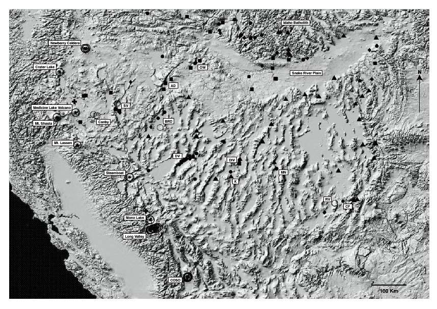
6 Our results, to date, of the regional helium isotope study are summarized in Figure 3. Three general trends are evident. First, all of the high helium isotope ratios (>3 Ra, black crosses and dotted circles) occur along the western margin of the Basin and Range. The ratios reflect high 3 He fluxes related to presently or recently active crustal magma systems of the Walker Lane shear zone and the Cascade volcanic chain. From south to north these systems are: Coso, Long Valley, Mono Lake, Steamboat, Lassen, Shasta, Medicine Lake, Crater Lake, and Newbury Caldera. Second, excluding the volcanic centers, the preponderance of elevated ratios (>0.6 Ra, black diamonds, squares, and open circles) occur in the northwest Basin and Range, the Snake River Plain, and parts of the Idaho Batholith. In some cases these elevated ratios may be related to the Cascade volcanics, but for the most part they are associated with regions of little or no recent volcanism and occur along range front faults. Third, moving east away from the western margin and elevated ratios of the northwest, the helium ratios quickly subside to values <0.6 Ra (black circles), with values <0.3 Ra (black triangles) dominating the central and eastern Basin and Range. Superimposed on this latter regional trend are features which have elevated helium isotope ratios ( Ra) compared to the local background [e.g. Black Rock Desert (BRD), Dixie Valley (DV), Diamond Valley (DIV), and Monte Neva (MN)]. As is the case for Dixie Valley discussed above, the features are located along range front faults and the local geology indicates that they are not related to current or recent magmatic activity, suggesting that the He-spikes reflect local zones of deep permeability. However, most of the features with low 3 He/ 4 He ratios (<0.3 Ra, black triangles) are also associated with range front fault systems. Therefore, not all range front fault systems transmit fluids with a strong mantle signature, implying that not all have comparable deep permeability. The northwest and central Basin and Range are characterized by high angle normal faults striking northeast- southwest. Seismic activity along these faults is related to the present day extension rates. The central seismic zone, a NE-SW trending zone of high seismicity, passes through Dixie Valley and marks a boundary between decelerating extension and relatively low seismic activity to the east and accelerating extension and high seismicity to the west (Parsons, 1995). The majority of elevated helium ratios occur west of this zone where extension is accelerating with concurrent high seismicity, indicating a cause and effect relationship between deep permeability and high extension rates, as logically expected. The extensional fabric of the northwest Basin and Range appears to extend into the Idaho Batholith, which is characterized by both NE-SW striking normal faults in the northwest sector of the batholith and NW-SE striking faults in the southeast sector. All of the springs associated with NE-SW faults have elevated helium ratios consistent with extension and deep permeability. Whereas, those along NW-SE faults tend to have ratios 0.3 Ra, suggesting a lack of deep permeability along faults that strike perpendicular to the extensional fabric. It is likely that deep permeable pathways are a necessity in the development of a viable geothermal resource in the Basin and Range. The deep pathways provide access to high temperature and can host fluid convection cells. Obviously more work needs to be done, but it appears that helium isotopes may provide the best and perhaps only tool for locating faults with deep and high enough permeability to host an economic geothermal
7 system. Future work will concentrate on more detailed studies of those areas with elevated ratios, the transition zone between the Basin and Range and the Cascade volcanic arc, and establishing a link between zones of high permeability and known geothermal resources. Furthermore, mapping of isotopic and geochemical information into a tectonic and geophysical context will facilitate a better understanding of these systems and their spatial distribution across the Basin and Range. Acknowledgements This work was supported by the U. S. Department of Energy, Office of Basic Energy Sciences and Office of Geothermal Technologies under contract DE-AC03-76SF References Blackwell, D.D., Gollan, B., and Benoit, D., 2000, Temperatures in the Dixie Valley, Nevada, geothermal system. Geothermal Resources Council, Trans., 24, pp Blackwell, D.D., Leidig, M., and Smith, R.P., 2002, Regional geophysics of the Dixie Valley area: example of a large Basin and Range geothermal system. Geothermal Resources Council, Trans., 26, pp Christenson, B.W., Mrocek, E.K., Kennedy, B.M., van Soest, T., Stewart, M.K., and Lyon, G. 2002, Ohaaki reservoir chemistry: Charateristics of an arc-type hydrothermal system in the Taupo Volcanic Zone, New Zealand. J. Volc. Geothermal. Res., v.115, Dodson, A., DePaolo, D.J. and Kennedy, B.M., 1998, Helium isotopes in lithospheric mantle: evidence from Tertiary basalts of the western USA. Geochim. Cosmochim Acta, 62, pp Goff, F., Bergfeld, D., Janik, C.J., Counce, D., and Murrell, M Geochemical data on waters, gases, scales, and rocks from the Dixie Valley region, Nevada ( ), LA Report LA-13792, Los Alamos National Laboratory, Los Alamos, NM. Hilton, D. R The helium and carbon isotope systematics of a continental geothermal system: results from monitoring studies at Long Valley caldera (California, USA). Chemical Geology, Jarchow, C. M., Thompson, G. A., Catchings, R. D., and Mooney, W. D., 1993, Seismic evidence for active magmatic underplating beneath the Basin and Range Province, Western United States, J. Geophys. Res., 98, pp 22,095-22,108. Kennedy, B. M. and Truesdell, A. H., 1996, The Northwest Geysers high-temperature reservoir: evidence for active magmatic degassing and implications for the origin of The Geysers Geothermal Field, Geothermics, 25 (3), pp Kennedy, B.M. and van Soest, M.C. 2005, A helium isotope perspective on the Dixie Valley, Nevada hydrothermal system. Geothermics (submitted).
8 Kennedy, B. M., Lynch, M. A., Smith, S. P., and Reynolds, J. H., 1985, Intensive sampling of noble gases in fluids at Yellowstone: I. Early overview of the data; regional patterns, Geochim. Cosmochim. Acta, 49, pp Kennedy B.M., Benoit D., and Truesdell A.H. 1996, A preliminary survey of noble gases at Dixie Valley, Nevada. Trans. Geotherm.Res. Council 20, pp Kennedy B.M., Kharaka Y.K., Evans W.C., Ellwood A., DePaolo D.J., Thordsen J., Ambats G., and Mariner R.H., 1997, Mantle fluids in the San Andreas fault system, California. Science, 278, pp Parsons, T., 1995, The Basin and Range Province. In: Continental Rifts: Evolution, Structure, Tectonics. K.H. Olsen (ed.), Developments in Geotectonics 25, Publication #264 of the International Lithosphere Program. Elsevier, New York, NY, pp Reid, M.R. and Graham, D.W., 1996, Resolving lithospheric and sub-lithospheric contributions to helium isotope variations in basalts from southwestern U.S. Earth Planet. Sci. Lett., 144, pp Saar, M. O., Castro, M. C., Hall, C. M., Manga, M. & Rose, T. P Quantifying magmatic, crustal, and atmospheric helium contributions to volcanic aquifers using all stable noble gases: Implications for magmatism and groundwater flow. Geochemistry Geophysics Geosystems, 6, #3, doi: /2004gc p. Sorey M.L., Kennedy B.M., Evans W.C., Farrar C.D., and Suemnicht G.A., 1993, Helium isotope variations associated with crustal unrest in Long Valley Caldera, California, in J. Geophys. Res., 98, pp Torgersen T., 1993, Defining the role of magmatism in extensional tectonics: helium 3 fluxes in extensional basins. J. Geophys. Res., 98, B9, pp 16,257-16,269. Welhan, J. A., Poreda, R. J. Rison, W., & Craig, H. 1988a Helium isotopes in geothermal and volcanic gases of the western United States, I. Regional variability and magmatic origin. Journal of Volcanology and Geothermal Research, 34, Welhan, J. A., Poreda, R. J. Rison, W., & Craig, H. 1988b Helium isotopes in geothermal and volcanic gases of the western United States, II. Long Valley Caldera. Journal of Volcanology and Geothermal Research, 34, Figure Captions Figure 1: Helium isotopic compositions of a variety of Dixie Valley fluids plotted as a function of the helium enrichment factor [F( 4 He)]. Filled black circles are hot springs and fumaroles, filled grey circles are wells outside of the geothermal field. The ellipse labeled DVGF represent the range in compositions found in the production fluids from the Dixie Valley Geothermal field (squares, triangles, and diamonds; symbol delineate
9 year of sampling). The dashed line depicts mixing between the DVG fluid and a younger, cooler shallow groundwater. The dotted line depicts either boiling and or air contamination (see text). Figure 2: Theoretical helium isotope west to east profile across the Basin and Range. Figure 3: Shaded relief sample location map of the Basin and Range (B&R) and surrounding areas. The different symbols give an indication of the magnitude of the 3 He/ 4 He at the locality. Coding is as follows: Black triangles 0.3 Ra; 0.3 Ra > Black circles 0.6 Ra; 0.6 Ra > Black diamonds 1.0 Ra; 1.0 Ra > Black Squares 2.0 Ra; 2.0 > Open circles 3.0 Ra; 3.0 Ra > Black cross 4.0 Ra; Dotted circle > 4.0 Ra. Certain features are labeled: SV: Surprise Valley; BRD: Black Rock Desert; AD: Alvord Desert; DV: Dixie Valley; OW: Owyhee River Canyon; DIV: Diamond Valley; K: Klobe hot spring: so far the lowest observed 3 He/ 4 He ratio in the B&R at Ra; MN: Monte Neva hot spring; RV: Roosevelt hot spring and geothermal energy plant; CF: Cove Fort geothermal energy plant. Additional datasources: Jenkins, unpublished data; used with permission; Welhan et al. 1988a,b; Hilton, 1996; Saar et al., Dixie HS SE Fum Senator's Toe R/Ra Jersey Senator Fum Sou Spr DVGF 0.4 GW Hyder Spr 0.3 McCoy HS 66-21?? F( 4 He) Figure 1

10 Figure 2 Figure 3
Parts of the Sevier/ Laramide Orogeny
 Parts of the Sevier/ Laramide Orogeny AA. Accretionary Prism BB. Forearc Basin Sediment scraped off of subducting plate Sediment derived from the volcanic arc CC. Volcanic Arc Magmatic intrusion into the
The High Lava Plains Project: Understanding the Causes of Continental Intraplate Tectonomagmatism
 The High Lava Plains Project: Understanding the Causes of Continental Intraplate Tectonomagmatism The High Lava Plains (HLP) of the northwestern USA is one of the most accessible yet least understood examples
Yellowstone National Park: Regional Groundwater Dynamics in High-Temperature Geothermal Areas
 International Symposium on Regional Groundwater Flow: Theory, Applications and Future Development Yellowstone National Park: Regional Groundwater Dynamics in High-Temperature Geothermal Areas K. Udo Weyer
Beneath our Feet: The 4 Layers of the Earty by Kelly Hashway
 Beneath our Feet: The 4 Layers of the Earty by Kelly Hashway The Earth is more than a giant ball made up of dirt, rocks, and minerals. The Earth may look like a giant ball from when looking at it from
Plate Tectonics Lab II: Background Information
 Plate Tectonics Lab II: Background Information This lab is based on a UW ESS101 Lab. Note: Hand in only the Answer Sheet at the back of this guide to your Instructor Introduction One of the more fundamental
Full file at
 Chapter 2 PLATE TECTONICS AND PHYSICAL HAZARDS MULTIPLE-CHOICE QUESTIONS 1. What direction is the Pacific Plate currently moving, based on the chain of Hawaiian Islands with only the easternmost island
Ann Moulding and Tom Brikowski University of Texas at Dallas, Department of Geosciences
 GRC Transactions, Vol. 39, 2015 Influence of Continuously Variable Permeability and Basin Rock Properties on Three Dimensional Heat and Mass Balance Models of Basin & Range Geothermal Systems Ann Moulding
Mt St Helens was know to have entered into active periods that lasted from years once every years over the last 500 years, (Figure 5).
.") Lecture #8 notes; Geology 3950, Spring 2006; CR Stern May 1980 eruption of Mt St Helens volcano (text pages 183-192 in the 4 th edition and 206-222 in the 5 th edition) Mt St Helens in southwest Washington
Lecture #8 notes; Geology 3950, Spring 2006; CR Stern May 1980 eruption of Mt St Helens volcano (text pages 183-192 in the 4 th edition and 206-222 in the 5 th edition) Mt St Helens in southwest Washington
ABSTRACT. * ,
 Geothermal systems in the Great Basin, western United States: Modern analogues to the roles of magmatism, structure, and regional tectonics in the formation of gold deposits Mark F. Coolbaugh* Great Basin
Crustal Boundaries. As they move across the asthenosphere and form plate boundaries they interact in various ways. Convergent Transform Divergent
 Name: Date: Period: Plate Tectonics The Physical Setting: Earth Science CLASS NOTES Tectonic plates are constantly moving and interacting As they move across the asthenosphere and form plate boundaries
Plate Tectonics. entirely rock both and rock
 Plate Tectonics I. Tectonics A. Tectonic Forces are forces generated from within Earth causing rock to become. B. 1. The study of the origin and arrangement of Earth surface including mountain belts, continents,
PLATE TECTONIC PROCESSES
 Lab 9 Name Sec PLATE TECTONIC PROCESSES 1. Fill in the blank spaces on the chart with the correct answers. Refer to figures 2.3, 2.4 p.33 (2.2 and 2.3 on p. 23) as needed. 2. With your knowledge of different
Continental Margin Geology of Korea : Review and constraints on the opening of the East Sea (Japan Sea)
") Continental Margin Geology of Korea : Review and constraints on the opening of the East Sea (Japan Sea) Han-Joon Kim Marine Satellite & Observation Tech. Korea Ocean Research and Development Institute
Continental Margin Geology of Korea : Review and constraints on the opening of the East Sea (Japan Sea) Han-Joon Kim Marine Satellite & Observation Tech. Korea Ocean Research and Development Institute
Regional and local variations in geochemistry and tectonics along and across Central America
 Regional and local variations in geochemistry and tectonics along and across Central America Michael J. Carr, Department of Geological Sciences, Wright Lab Rutgers University, 610 Taylor Rd., Piscataway
Exploration of Geothermal High Enthalpy Resources using Magnetotellurics an Example from Chile
 Exploration of Geothermal High Enthalpy Resources using Magnetotellurics an Example from Chile Ulrich Kalberkamp, Federal Institute for Geosciences and Natural Resources (BGR), Stilleweg 2, 30655 Hannover,
CO 2 and heat fluxes in the Apennines, Italy
 CO 2 and heat fluxes in the Apennines, Italy Giovanni Chiodini (INGV, sezione di Bologna, Italy) CO 2 Earth degassing and climate changes CO 2 Earth degassing and tectonics CO 2 flux Mt yr 1 Fossil fuels
EVALUATING HEAT FLOW AS A TOOL FOR ASSESSING GEOTHERMAL RESOURCES
 PROCEEDINGS, Thirtieth Workshop on Geothermal Reservoir Engineering Stanford University, Stanford, California, January 31-February 2, 2005 SGP-TR-176 EVALUATING HEAT FLOW AS A TOOL FOR ASSESSING GEOTHERMAL
Continental Drift. & Plate Tectonics
 Continental Drift & Plate Tectonics Alfred Wegener, a German scientist, proposed the hypothesis of CONTINENTAL DRIFT, in 1912. Hypothesis stated: All Earth s continents were once a single landmass (Pangaea)
Earthquakes. Earthquakes are caused by a sudden release of energy
 Earthquakes Earthquakes are caused by a sudden release of energy The amount of energy released determines the magnitude of the earthquake Seismic waves carry the energy away from its origin Fig. 18.1 Origin
MIGRATING SWARMS OF BRITTLE-FAILURE EARTHQUAKES IN THE LOWER CRUST BENEATH MAMMOTH MOUNTAIN, CALIFORNIA
 MIGRATING SWARMS OF BRITTLE-FAILURE EARTHQUAKES IN THE LOWER CRUST BENEATH MAMMOTH MOUNTAIN, CALIFORNIA David Shelly and David Hill GRL, October 2011 Contents Tectonic Setting Long Valley Caldera Mammoth
From Punchbowl to Panum: Long Valley Volcanism and the Mono-Inyo Crater Chain
 From Punchbowl to Panum: Leslie Schaffer E105 2002 Final Paper Long Valley Volcanism and the Mono-Inyo Crater Chain Figure 1. After a sequence of earthquakes during the late 1970 s to the early 1980 s
THERMAL THERMAL AND AND RHEOLOGIC SIGNATURES OF
 THERMAL THERMAL AND AND RHEOLOGIC SIGNATURES OF OF HIGH HIGH ENTHALPY ENTHALPY RESOURCES ENGINE ENGINE Workshop Workshop Exploring Exploring high high temperature temperature reservoirs: reservoirs: new
Geophysical Surveys of The Geothermal System of The Lakes District Rift, Ethiopia
 Geophysical Surveys of The Geothermal System of The Lakes District Rift, Ethiopia By: Befekadu Oluma By: Geophysics Department Geological Survey of Ethiopia The formation of the rift was preceded by a
Late Tertiary Volcanism. North Washington. Other Andesite Volcanoes. Southern Washington. High Cascades. High Cascades. Mid-Miocene Miocene to present
 Miocene to Present Late Tertiary Volcanism Mid-Miocene Miocene to present Reading: DNAG volume G3, Ch. 7 High Cascade Range Columbia River Snake River Plain Basin and Range Southwestern California Sierra
12. The diagram below shows the collision of an oceanic plate and a continental plate.
 Review 1. Base your answer to the following question on the cross section below, which shows the boundary between two lithospheric plates. Point X is a location in the continental lithosphere. The depth
David I. Norman and Joseph N. Moore
 PROCEEDINGS, TwentyThird Workshop on Geothermal Reservoir Engineering Stanford University, Stanford, California, January 2527, 1999 SGPTR162 METHANE AND EXCESS AND Ar IN GEOTHERMAL FLUID INCLUSIONS David
Topic 12: Dynamic Earth Pracatice
 Name: Topic 12: Dynamic Earth Pracatice 1. Earth s outer core is best inferred to be A) liquid, with an average density of approximately 4 g/cm 3 B) liquid, with an average density of approximately 11
Heat (& Mass) Transfer. conceptual models of heat transfer. large scale controls on fluid movement. distribution of vapor-saturated conditions
 Transfer. conceptual models of heat transfer. large scale controls on fluid movement. distribution of vapor-saturated conditions") Heat (& Mass) Transfer conceptual models of heat transfer temperature-pressure gradients large scale controls on fluid movement distribution of vapor-saturated conditions fluid flow paths surface manifestations
Heat (& Mass) Transfer conceptual models of heat transfer temperature-pressure gradients large scale controls on fluid movement distribution of vapor-saturated conditions fluid flow paths surface manifestations
The continental lithosphere
 Simplicity to complexity: The continental lithosphere Reading: Fowler p350-377 Sampling techniques Seismic refraction Bulk crustal properties, thickness velocity profiles Seismic reflection To image specific
3. PLATE TECTONICS LAST NAME (ALL IN CAPS): FIRST NAME: PLATES
: FIRST NAME: PLATES") LAST NAME (ALL IN CAPS): FIRST NAME: PLATES 3. PLATE TECTONICS The outer layers of the Earth are divided into the lithosphere and asthenosphere. The division is based on differences in mechanical properties
LAST NAME (ALL IN CAPS): FIRST NAME: PLATES 3. PLATE TECTONICS The outer layers of the Earth are divided into the lithosphere and asthenosphere. The division is based on differences in mechanical properties
Practice Questions: Plate Tectonics
 Practice Questions: Plate Tectonics 1. Base your answer to the following question on The block diagram below shows the boundary between two tectonic plates. Which type of plate boundary is shown? A) divergent
Evidence for a Magmatic Source of Heat for the Steamboat Springs Geothermal System Using Trace Elements and Gas Geochemistry
 Geothermal Resources Council Transactions, Vol. 27, October 12-1 5, 23 Evidence for a Magmatic Source of Heat for the Steamboat Springs Geothermal System Using Trace Elements and Gas Geochemistry Greg
Structure of the Earth and the Origin of Magmas
 Page 1 of 12 EENS 2120 Petrology Tulane University Prof. Stephen A. Nelson Structure of the Earth and the Origin of Magmas This document last updated on 23-Jan-2015 Magmas do not form everywhere beneath
Plate Tectonics. Structure of the Earth
 Plate Tectonics Structure of the Earth The Earth can be considered as being made up of a series of concentric spheres, each made up of materials that differ in terms of composition and mechanical properties.
GEOCHEMISTRY OF RWENZORI HOT SPRINGS. Vincent Kato Department of Geological Survey and Mines, Entebbe, Uganda
 GEOCHEMISTRY OF RWENZORI HOT SPRINGS Vincent Kato Department of Geological Survey and Mines, Entebbe, Uganda RWENZORI Length of 115Km Width of central dome 48 64 km Highest peak >5105m SnowyMountain Lakes
Geothermal Systems: Geologic Origins of a Vast Energy Resource
 Geothermal Systems: Geologic Origins of a Vast Energy Resource Energy From the Earth Energy-Land-Water Connections Speaker Series James E. Faulds, PhD Nevada State Geologist and Professor Nevada Bureau
An Introduction of Aleutian Subduction Zone. Chuanmao Yang, Hong Yang, Meng Zhang, Wenzhong Wang 2016/04/29
 An Introduction of Aleutian Subduction Zone Chuanmao Yang, Hong Yang, Meng Zhang, Wenzhong Wang 2016/04/29 Outline General Introduction Formation history Structure from seismic study geochemical features
Bog Hot Valley. (updated 2012)
") Bog Hot Valley (updated 2012) Geologic setting: Bog Hot Valley is located along a major fault lineament between Soldier Meadows Hot Springs and Oregon (figure; Hose and Taylor, 1974). This lineament can
Bog Hot Valley (updated 2012) Geologic setting: Bog Hot Valley is located along a major fault lineament between Soldier Meadows Hot Springs and Oregon (figure; Hose and Taylor, 1974). This lineament can
MAR110 LECTURE #6 West Coast Earthquakes & Hot Spots
 17 September 2007 Lecture 6 West Coast Earthquakes & Hot Spots 1 MAR110 LECTURE #6 West Coast Earthquakes & Hot Spots Figure 6.1 Plate Formation & Subduction Destruction The formation of the ocean crust
FLUID-INCLUSION GAS CHEMISTRY OF THE DIXIE VALLEY (NV) GEOTHERMAL SYSTEM
 GEOTHERMAL SYSTEM") PROCEEDINGS, Twenty-Seventh Workshop on Geothermal Reservoir Engineering Stanford University, Stanford, California, January 28-30, 2002 SGP-TR-171 FLUID-INCLUSION GAS CHEMISTRY OF THE DIXIE VALLEY (NV)
PROCEEDINGS, Twenty-Seventh Workshop on Geothermal Reservoir Engineering Stanford University, Stanford, California, January 28-30, 2002 SGP-TR-171 FLUID-INCLUSION GAS CHEMISTRY OF THE DIXIE VALLEY (NV)
Opportunities for Geothermal Development Created by New Technologies S2-1-2
 Opportunities for Geothermal Development Created by New Technologies S2-1-2 Geothermal Academy Masami Nakagawa Director of Geothermal Academy Fulbright Energy Specialist CSM/NREL Joint Appointee Department
INVERSION OF SYNTHETIC APERTURE RADAR INTERFEROGRAMS FOR SOURCES OF PRODUCTION-RELATED SUBSIDENCE AT THE DIXIE VALLEY GEOTHERMAL FIELD
 PROCEEDINGS, Twenty-Eighth Workshop on Geothermal Reservoir Engineering Stanford University, Stanford, California, January 27-29, 2003 SGP-TR-173 INVERSION OF SYNTHETIC APERTURE RADAR INTERFEROGRAMS FOR
A) B) C) D) 4. Which diagram below best represents the pattern of magnetic orientation in the seafloor on the west (left) side of the ocean ridge?
 B) C) D) 4. Which diagram below best represents the pattern of magnetic orientation in the seafloor on the west (left) side of the ocean ridge?") 1. Crustal formation, which may cause the widening of an ocean, is most likely occurring at the boundary between the A) African Plate and the Eurasian Plate B) Pacific Plate and the Philippine Plate C)
1. Crustal formation, which may cause the widening of an ocean, is most likely occurring at the boundary between the A) African Plate and the Eurasian Plate B) Pacific Plate and the Philippine Plate C)
Science 10 PROVINCIAL EXAM STUDY BOOKLET. Unit 4. Earth Science
 Science 10 PROVNCAL EXAM STUDY BOOKLET Unit 4 Earth Science Student nstructions 1. Ensure that you have blank paper and a Data Booklet. 2. Record all answers on a separate piece of paper. 3. Answer keys
GEOLOGY MEDIA SUITE Chapter 12
 UNDERSTANDING EARTH, SIXTH EDITION GROTZINGER JORDAN GEOLOGY MEDIA SUITE Chapter 12 Volcanoes 2010 W.H. Freeman and Company Plate tectonics explains the global pattern of volcanism. Key Figure 12.20 (page
MAR110 Lecture #5 Plate Tectonics-Earthquakes
 1 MAR110 Lecture #5 Plate Tectonics-Earthquakes Figure 5.0 Plate Formation & Subduction Destruction The formation of the ocean crust from magma that is upwelled into a pair of spreading centers. Pairs
Lab 1: Plate Tectonics April 2, 2009
 Name: Lab 1: Plate Tectonics April 2, 2009 Objective: Students will be introduced to the theory of plate tectonics and different styles of plate margins and interactions. Introduction The planet can be
Geology 300, Physical Geology Spring 2019 Quiz Ch 19, Plate Tectonics Name
 Geology 300, Physical Geology Spring 2019 Quiz Ch 19, Plate Tectonics Name MULTIPLE CHOICE. Choose the one alternative that best completes the statement or answers the question. 1) The portion of a fracture
Plate Tectonics and the cycling of Earth materials
 Plate Tectonics and the cycling of Earth materials Plate tectonics drives the rock cycle: the movement of rocks (and the minerals that comprise them, and the chemical elements that comprise them) from
TAKE HOME EXAM 8R - Geology
 Name Period Date TAKE HOME EXAM 8R - Geology PART 1 - Multiple Choice 1. A volcanic cone made up of alternating layers of lava and rock particles is a cone. a. cinder b. lava c. shield d. composite 2.
Activity Pacific Northwest Tectonic Block Model
 Activity Pacific Northwest Tectonic Block Model The Cascadia tectonic margin is caught between several tectonic forces, during the relentless motions of the giant Pacific Plate, the smaller subducting
Dynamic Earth A B1. Which type of plate boundary is located at the Jordan Fault? (1) divergent (3) convergent (2) subduction (4) transform
 divergent (3) convergent (2) subduction (4) transform") Dynamic Earth A B1 1. The edges of most lithospheric plates are characterized by (1) reversed magnetic orientation (2) unusually rapid radioactive decay (3) frequent volcanic activity (4) low P-wave and
Dynamic Earth A B1 1. The edges of most lithospheric plates are characterized by (1) reversed magnetic orientation (2) unusually rapid radioactive decay (3) frequent volcanic activity (4) low P-wave and
EARTH S ENERGY SOURCES
 EARTH S ENERGY SOURCES The geological processes that shape the Earth s surface are powered by two major sources of energy; geothermal heat from the Earth s interior and external energy from the sun. The
Lecture #13 notes, Geology 3950 Spring 2006: CR Stern Magnetic reversals (text pages th edition and in the 5 th edition)
") Lecture #13 notes, Geology 3950 Spring 2006: CR Stern Magnetic reversals (text pages 35-37 4 th edition and 53-55 in the 5 th edition) The earth has a magnetic field generated by circulation of charged
Lecture #13 notes, Geology 3950 Spring 2006: CR Stern Magnetic reversals (text pages 35-37 4 th edition and 53-55 in the 5 th edition) The earth has a magnetic field generated by circulation of charged
Plate Tectonics Tutoiral. Questions. Teacher: Mrs. Zimmerman. Plate Tectonics and Mountains Practice Test
 Teacher: Mrs. Zimmerman Print Close Plate Tectonics and Mountains Practice Test Plate Tectonics Tutoiral URL: http://www.hartrao.ac.za/geodesy/tectonics.html Questions 1. Fossils of organisms that lived
Overview of Indonesian Geothermal System
 Overview of Indonesian Geothermal System The Resources Beyond High Enthalpy Magmatic/Volcanic Systems By Dr.Eng. Suryantini ITB 4/3/2017 1 Outline Current Condition of Indonesian Geothermal Resources and
Seismic image of a CO 2 reservoir beneath a seismically active volcano
 Geophys. J. Int. (1998) 133, F7^F10 FAST-TRACK PAPER Seismic image of a CO 2 reservoir beneath a seismically active volcano Bruce R. Julian, 1 A. M. Pitt 1 and G. R. Foulger 2 1 US Geological Survey, 345
Sustainable Energy Science and Engineering Center GEOTHERMAL ENERGY. Sustainable Energy Sources. Source:
 Sustainable Energy Sources GEOTHERMAL ENERGY Earth s Temperature Profile GEOTHERMAL ENERGY Plate Tectonics Earth's crust is broken into huge plates that move apart or push together at about the rate our
Geochemical monitoring of the response ofgeothermal reservoirs to production load examples from Krafla, Iceland
 International Geothermal Conference, Reykjavík, Sept. 23 Session #7 Geochemical monitoring of the response ofgeothermal reservoirs to production load examples from Krafla, Iceland Stefán Arnórsson 1 and
PHYSICAL GEOLOGY AND THE ENVIRONMENT (2 ND CANADIAN EDITION)
") Chapter 2: Plate Tectonics Chapter Summary: Plate tectonics is a theory that suggests Earth's surface is divided into several large plates that change position and size. Intense geologic activity occurs
Chapter 2: Plate Tectonics Chapter Summary: Plate tectonics is a theory that suggests Earth's surface is divided into several large plates that change position and size. Intense geologic activity occurs
Plate Tectonics: A Scientific Revolution Unfolds
 Chapter 2 Lecture Earth: An Introduction to Physical Geology Eleventh Edition Plate Tectonics: A Scientific Revolution Unfolds Tarbuck and Lutgens From Continental Drift to Plate Tectonics Prior to the
4-D Geodynamic Modeling With Data Assimilation: Subduction and Continental Evolution
 4-D Geodynamic Modeling With Data Assimilation: Subduction and Continental Evolution PI: Lijun Liu Department of Geology, University of Illinois at Urbana-Champaign Corresponding author: Lijun Liu, ljliu@illinois.edu
Alternative Mechanisms for Volcanic Activity in Hotspot-Ridge Systems: The Northern Galapagos Province
 ABSTRACT for the Plume IV Penrose Conference Alternative Mechanisms for Volcanic Activity in Hotspot-Ridge Systems: The Northern Galapagos Province Karen S. Harpp, Colgate University, Department of Geology,
. Slide 1. Geological Survey of Ethiopia, P.O.Box 2302, Addis Ababa, Ethiopia
 The electrical resistivity structure of the Southern Main Ethiopian Rift (around the Lake Abaya geothermal prospect) revealed by magneto-telluric telluric imaging Mohammednur Desissa and Yohanes Lema Geological
Course Syllabus (Contents Part 8) Geothermal Energy
 Geothermal Energy") Course Syllabus (Contents Part 8) PART 8 GEOTHERMAL ENERGY Geothermal energy Typical geothermal gradient Global geothermal resource Plate boundaries & hot spots Major geothermal regions US geothermal resources
Course Syllabus (Contents Part 8) PART 8 GEOTHERMAL ENERGY Geothermal energy Typical geothermal gradient Global geothermal resource Plate boundaries & hot spots Major geothermal regions US geothermal resources
What can isotopes tell us about mantle dynamics? Sujoy Mukhopadhyay. Harvard University
 What can isotopes tell us about mantle dynamics? Sujoy Mukhopadhyay Harvard University The mantle zoo Hofmann, 1997 187 Os/ 188 Os 0.168 0.156 0.144 0.132 EM1 Hawaii Pitcairn DMM peridotites Shield Basalts
Evidence from the Surface. Chapter 02. Continental Drift. Fossil Evidence for Pangaea. Seafloor Spreading. Seafloor Spreading 1/31/2012
 Evidence from the Surface Surface landforms Continental shelf and slope Abyssal Plane Mid-oceanic ridge Oceanic Trenches Chapter 02 Continental Drift Continental Drift - a hypothesis that the continents
Visualizing Earth Science. Chapter Overview. Volcanoes and Eruption Types. By Z. Merali and B. F. Skinner. Chapter 9 Volcanism and Other
 Visualizing Earth Science By Z. Merali and B. F. Skinner Chapter 9 Volcanism and Other Igneous Processes Volcanoes types and effects of eruption Chapter Overview Melting and cooling of rocks Geological
Tectonics. Planets, Moons & Rings 9/11/13 movements of the planet s crust
 Tectonics Planets, Moons & Rings 9/11/13 movements of the planet s crust Planetary History Planets formed HOT Denser materials fall to center Planet cools by conduction, convection, radiation to space
Geology of the Hawaiian Islands
 Geology of the Hawaiian Islands Class 3 20 January 2004 Any Questions? IMPORTANT Big Island Field Trip We need a firm commitment PLUS $164 payment for airfare BEFORE January 29th Plate Tectonics Fundamental
Plate Tectonics: The New Paradigm
 Earth s major plates Plate Tectonics: The New Paradigm Associated with Earth's strong, rigid outer layer: Known as the lithosphere Consists of uppermost mantle and overlying crust Overlies a weaker region
Overview of Ch. 4. I. The nature of volcanic eruptions 9/19/2011. Volcanoes and Other Igneous Activity Chapter 4 or 5
 Overview of Ch. 4 Volcanoes and Other Igneous Activity Chapter 4 or 5 I. Nature of Volcanic Eruptions II. Materials Extruded from a Volcano III.Types of Volcanoes IV.Volcanic Landforms V. Plutonic (intrusive)
Geol. 655 Isotope Geochemistry
 ISOTOPIC GEOCHEMISTRY OF THE CONTINENTAL CRUST Isotope systems have particular value in studies of mantle geochemistry because of the difficulty of obtaining direct, representative samples of mantle. Because
GEOTHERMAL POTENTIAL OF ST. KITTS AND NEVIS ISLANDS
 GEOTHERMAL POTENTIAL OF ST. KITTS AND NEVIS ISLANDS By Gerald W. Huttrer Geothermal Management Company, Inc. For the Eastern Caribbean Geothermal Energy Project ( Geo- Caraibes ; G-C ) Presented Using
What can noble gases really say about mantle. 2) Extent of mantle degassing
 Extent of mantle degassing") What can noble gases really say about mantle convection and the deep Earth volatile cycles? 1) Constraints on mass flow 1) Constraints on mass flow 2) Extent of mantle degassing Outline: -Noble gas geochemistry
What can noble gases really say about mantle convection and the deep Earth volatile cycles? 1) Constraints on mass flow 1) Constraints on mass flow 2) Extent of mantle degassing Outline: -Noble gas geochemistry
COUPLING AND DECOUPLING OF HEAT AND HELIUM TRANSPORT IN A GEOTHERMAL RESERVOIR
 PROCEEDINGS, TOUGH Symposium 26 Lawrence Berkeley National Laboratory, Berkeley, California, May 15 17, 26 COUPLING AND DECOUPLING OF HEAT AND HELIUM TRANSPORT IN A GEOTHERMAL RESERVOIR Judith L. Andrews
Dynamic Crust Practice
 1. Base your answer to the following question on the cross section below and on your knowledge of Earth science. The cross section represents the distance and age of ocean-floor bedrock found on both sides
24. Ocean Basins p
 24. Ocean Basins p. 350-372 Background The majority of the planet is covered by ocean- about %. So the majority of the Earth s crust is. This crust is hidden from view beneath the water so it is not as
A Revised Interpretation of 3D Seismic Data, Hawthorne Army Depot, Nevada: Faulted Basin Reflections or Sill Intrusions?
 A Revised Interpretation of 3D Seismic Data, Hawthorne Army Depot, Nevada: Faulted Basin Reflections or Sill Intrusions? Annie Kell Hills 1, Louie, J. 1, Kent, G. 1, Pullammanappallil, S. 2, Sabin, A.
USU 1360 TECTONICS / PROCESSES
 USU 1360 TECTONICS / PROCESSES Observe the world map and each enlargement Pacific Northwest Tibet South America Japan 03.00.a1 South Atlantic Arabian Peninsula Observe features near the Pacific Northwest
Most mafic magmas come from the upper mantle and lower crust. This handout will address five questions:
 Geology 101 Origin of Magma From our discussions of the structure of the interior of the Earth, it is clear that the upper parts of the Earth (crust and mantle) are mostly solid because s-waves penetrate
Using impact exsolution to link the Chicxulub collision and Deccan volcanism
 Using impact exsolution to link the Chicxulub collision and Deccan volcanism Kevin G. Harrison 1 1 Geosciences Department, 100 West College Street, PO Box 810, Denison University, Granville, OH 43023-0810
Magmatism in Western Cascades Arc. Early Tertiary Magmatism Part II. Washington Magmatism. Western Oregon. Southern Oregon
 Early Tertiary Magmatism Part II Reference: DNAG v. 3, Ch. 7, pp 294-314 Magmatism in Western Cascades Arc Active from 38 to 17 Ma New volcanic activity west of Clarno Fm and south into Oregon Western
Copyright McGraw-Hill Education. All rights reserved. No reproduction or distribution without the prior written consent of McGraw-Hill Education
 Copyright McGraw-Hill Education. All rights reserved. No reproduction or distribution without the prior written consent of McGraw-Hill Education Tibetan Plateau and Himalaya -southern Asia 11.00.a VE 10X
Thermal Modeling of the Mountain Home Geothermal Area
 PROCEEDINGS, 41st Workshop on Geothermal Reservoir Engineering Stanford University, Stanford, California, February 22-24, 2016 SGP-TR-209 Thermal Modeling of the Mountain Home Geothermal Area Sabodh K.
The Devils Postpile and its Unusual Surroundings. Shannon B. Carpenter A May 3, 2001
 The Devils Postpile and its Unusual Surroundings Shannon B. Carpenter A25584605 May 3, 2001 Abstract: The Devils Postpile is located in the eastern Sierra Nevada region just a few miles southwest of the
Japan Engineering Consultants, Inc., Energy and Industrial Technology Development Organization,Tokyo, Japan
 DEEP GEOTHERMAL STRUCTURE AND THE HYDROTHERMAL SYSTEM THE GEOTHERMAL FIELD, JAPAN M. H. K. MATSUDA', T. K. Japan Engineering Consultants, Inc., Japan Energy and Industrial Technology Development Organization,Tokyo,
Geology 15 West Valley College. Exam IV: Sierra Nevada
 Geology 15 West Valley College Name Exam IV: Sierra Nevada 1) On the diagram above, where is the Arc- Trench Gap? a. 1 and 3 c. 7 and 8 d. 6 e. 5 and 10 2) On the diagram above, where is the subduction
Targeting of Potential Geothermal Resources in the Great Basin from Regional Relationships between Geodetic Strain and Geological Structures
 Targeting of Potential Geothermal Resources in the Great Basin from Regional Relationships between Geodetic Strain and Geological Structures Geoffrey Blewitt and Mark Coolbaugh Great Basin Center for Geothermal
1.4 Notes: Plates Converge or Scrape Past Each Other Think About Tectonic Plates Push Together at Convergent Boundaries
 1.4 Notes: Plates Converge or Scrape Past Each Other Think About If new crust is created at divergent boundaries, why does the total amount of crust on Earth stay the same? Tectonic Plates Push Together
NOTICE CONCERNING COPYRIGHT RESTRICTIONS
 NOTICE CONCERNING COPYRIGHT RESTRICTIONS This document may contain copyrighted materials. These materials have been made available for use in research, teaching, and private study, but may not be used
Dynamic Subsidence and Uplift of the Colorado Plateau. Supplementary Material
 GSA DATA REPOSITORY 2010177 Liu and Gurnis Dynamic Subsidence and Uplift of the Colorado Plateau Supplementary Material Lijun Liu and Michael Gurnis Seismological Laboratory California Institute of Technology
I know that dinosaurs were not very big at the time of the end Triassic extinction, but this graphic from the National Science Foundation website
 I know that dinosaurs were not very big at the time of the end Triassic extinction, but this graphic from the National Science Foundation website sets the theme of mass extinction by fissure volcanism.
Plate Boundaries. Presented by Kesler Science
 Presented by Kesler Science Essential Questions: 1. What is plate tectonics? 2. What are the three types of plate boundaries? 3. What crustal features are formed at plate boundaries? Quick Action INB Template
REVIEW: The Setting - Climatology of the Hawaiian Archipelago
 REVIEW: The Setting - Climatology of the Hawaiian Archipelago Atmosphere and Ocean 5 facts: NE trade-winds tropical water subtropical gyre Seasonality N S gradients Four dominant swell regimes: north Pacific
SUPPLEMENTARY INFORMATION
 doi:10.1038/nature10326 Supplementary Discussion All known modern terrestrial mantle reservoirs evolved from a primitive precursor with superchondritic 143 Nd/ 144 Nd. What is this reservoir? The terms
6. In the diagram below, letters A and B represent locations near the edge of a continent.
 1. Base your answer to the following question on the cross section below and on your knowledge of Earth science. The cross section represents the distance and age of ocean-floor bedrock found on both sides
In Situ Estimates of Sub-Crustal Continental Lithospheric Heat Flow: Application to the Slave and Kaapvaal Cratons
 In Situ Estimates of Sub-Crustal Continental Lithospheric Heat Flow: Application to the Slave and Kaapvaal Cratons Paul Morgan 1,2 and Suzanne Y. O Reilly 2 1 Department of Geology, Box 4099, Northern
Directed Reading. Section: How Mountains Form MOUNTAIN RANGES AND SYSTEMS. Skills Worksheet
 Skills Worksheet Directed Reading Section: How Mountains Form 1. How high is Mount Everest? a. about 1980 km above sea level b. more than 8 km below sea level c. more than 8 km above sea level d. more
Geologic Evolution of Latin America. Plate Tectonics: General Concepts & Applications to Latin America
 Geologic Evolution of Latin America Plate Tectonics: General Concepts & Applications to Latin America Structure of Earth: 3 major divisions of Core, Mantle, and Crust Upper mantle differs in the way that