ENVIRONMENTAL ADVISORS
|
|
|
- Meryl Kelley
- 5 years ago
- Views:
Transcription
1 PRELIMINARY GEOTECHNICAL ASSESSMENT BALL ROAD BASIN GENERAL PLAN AMENDMENT AND ZONE CHANGE PROJECT ANAHEIM, CALIFORNIA Prepared for ENVIRONMENTAL ADVISORS 2390 East Orangewood Avenue, Suite 510 Anaheim, California Project No March 18, 2013 (Revised June 13, 2013)
2 March 18, 2013 (Revised June 13, 2013) Project No Environmental Advisors 2390 East Orangewood Avenue, Suite 510 Anaheim, California Attention: Subject: Mr. Joshua Haskins Preliminary Geotechnical Assessment Ball Road Basin General Plan Amendment and Zone Change Project Anaheim, California In accordance with your request and authorization, Leighton Consulting, Inc. has performed a geotechnical assessment for Ball Road Basin General Plan Amendment and Zone Change Project in Anaheim, California. The Orange County Water District (OCWD) operates the site as a groundwater recharge basin. Since the Ball Road Basin no longer performs well as a groundwater recharge facility, OCWD is pursuing the option of selling or leasing it for commercial development. The purpose of this study was to assess the potential geologic, soils, and seismic impacts that could affect design and construction of future development. Our review in preparation of this report has incorporated available published geologic and geotechnical information and data from the project site and projects in the site vicinity. This report summarizes our findings and presents possible mitigation measures for potentially significant impacts identified in this report. During this study, we have not identified any geotechnical impacts within the subject site that cannot be mitigated by proper planning, design and sound construction practices. A geotechnical investigation that includes adequate subsurface exploration and laboratory testing should be performed during future phases of the project.
3 We appreciate the opportunity to provide our services for this interesting project. If you have any questions, please contact this office at your convenience. Respectfully submitted, LEIGHTON CONSULTING, INC. SP/DJC/lr Distribution: (1) Addressee Djan Chandra, GE 2376 Senior Principal Engineer 2
4 TABLE OF CONTENTS Section Page 1.0 INTRODUCTION Purpose and Scope of Work Site Location and Description Proposed Project GEOTECHNICAL CONDITIONS Regional Geologic Setting Local Geology Groundwater Regional Faulting and Seismicity POTENTIAL GEOTECHNICAL HAZARDS Fault Displacement/Ground Rupture Seismic Ground Shaking Secondary Effects of Seismic Shaking Land Subsidence Extraction Hydroconsolidation Compressible Soils Slope Stability Unstable Slopes Landslides and Mudflows Flooding Grading Impacts Volcanic Hazards FUTURE GEOTECHNICAL INVESTIGATION REFERENCES Figures i
5 Figure 1 Site Location Map Page 3 Figure 2 Regional Geologic Map Page 7 Figure 3 Fault Activity Map Page 8 Figure 4 Seismic Hazard Zone Map Page 9 Appendix A Boring and CPT Logs Provided by OCWD ii
6 INTRODUCTION 1.1 Purpose and Scope of Work The purpose of this study was to evaluate the potential geotechnical and seismic impacts that may affect future development at the Ball Road Basin (Assessor s Parcel Numbers [APNs] , and ), hereafter referred to as the Project site. The findings presented in this report are preliminary based on the information gained from review of published documents. Field exploration and laboratory testing should be conducted during any future development at the project site to verify these findings. Our scope of work consisted of the following tasks: Review of available published documents and geology maps covering geotechnical conditions at the site and its vicinity, including the geotechnical reports for the proposed Burris Pump Station Rehabilitation (Leighton, 2013) and widening of State Route (SR)-57 at Ball Road (Leighton, 2010). A list of references used in preparation of this report is presented in Section 5.0; Site reconnaissance to evaluate the current site conditions and to observe potential geologic or geotechnical constraints; Seismic analysis for the major active and potentially active faults in the region and a site-specific evaluation of ground motion using the probabilistic approach; Geotechnical analysis of the collected data with respect to the proposed project; and Preparation of this report presenting the site geotechnical conditions and hazards and preliminary geotechnical recommendations. 1.2 Site Location and Description As part of an Orange County Water District (OCWD) groundwater recharge program, several recharge basins were established along the Santa Ana River (River). The Project site, located at the southeast corner of Ball Road and South Phoenix Club Drive in the City of Anaheim (City), is the most down-gradient recharge basin in OCWD s Off-River System. The Project site is approximately 1
7 acres containing a broad, semi-rectangular pit, with a holding capacity of about 220 acre-feet of water and bound by the Santa Ana River Center Levee and the River to the east, Ball Road and the Burris Basin to the north, the Union Pacific Railroad to the south, and South Phoenix Club Drive (also referred to as South Auto Center Drive) to the west (Figure 1, Site Location Map). The Project site was purchased in 1943 by OCWD and was separated from the River in the early 1970s with the construction of a levee, called the Center Levee. Elevations on the Project site range from approximately 155 feet at the invert to approximately 180 feet at the top-of-grade. Topography of the general vicinity slopes towards the west. The Project site is unpaved and contains bare soil and weedy vegetation with standing water during rain events. Structures or roads were not observed on the Project site with the exception of unpaved access roads around the perimeter. 1.3 Proposed Project OCWD analyzed the percolation rates of the Project site and its effectiveness as a recharge basin. The site was found to be incapable of significant amounts of recharge due to an extensive clay layer underlying the majority of the basin. OCWD has decided to pursue the option of selling or leasing the site for commercial uses and is in the process of preparing technical documents to support an Environmental Impact Report (EIR) that proposes to amend the City s General Plan Land Use Element Map and Zoning Map for the Project site. If the map amendments are approved, an approximately 425,000 square foot commercial development, which complies with the development standards of the General Commercial (C-G) Zone (maximum floor area ratio of 0.5), can be constructed on the Project site without further environmental review. It is anticipated that construction and excavation for future construction on-site could include placement of 15 to 25 feet of compacted fill to raise the site grade to the elevations of the surrounding streets. 2


8 Lincoln Ave Glassell St?uE East St Approximate Site Location Ball Rd Taft Ave State College Blvd Katella Ave Collins Ave ³ 0 2,000 4,000 Feet Project: Scale: 1 " = 2,000 ' Base Map: ESRI Resource Center 2013 Thematic Info: Leighton Author: Leighton Geomatics (mmurphy) Eng/Geol: DJC/MDC Date: March, 2013 SITE LOCATION MAP Ball Road Basin Anaheim, California Copyright: 2011 National Geographic Society, i-cubed Figure 1 Leighton Map Saved as P:\drafting\10113\002\GIS\of_ \Figure1.mxd on 3/15/2013 4:51:08 PM
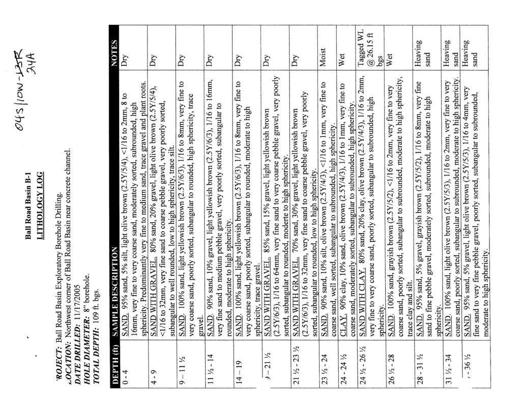
9 GEOTECHNICAL CONDITIONS 2.1 Regional Geologic Setting The Project site is located in the Tustin Plain within the southeastern margin of the Los Angeles Basin, a large structural depression within the Peninsular Ranges geomorphic province of California. In general, the Tustin Plain consists of approximately 1,400 feet of unconsolidated to semi-consolidated Quaternaryage alluvial sediments. Underlying the Quaternary alluvial deposits are Tertiaryage bedrock units consisting of sandstone, siltstone, shale and conglomerate on the order of 31,000 feet in thickness. The site lies near the lower reaches of the River. The surface distribution of Holocene sediments, as recorded in early editions of regional soil survey maps (Eckmann et al., 1916), suggests that the River has recently wandered back and forth across the Orange County coastal plain from Alamitos Bay to Newport Bay. Historical accounts and documents further support the process of widespread sheet flooding being the dominant depositional process associated with the River prior to the construction of Prado Dam in 1941 (California Department of Water Resources, 1957). Currently, the River is located east of the Project site. A geology map of the area is presented on Figure 2, Regional Geology Map. 2.2 Local Geology The Project site is underlain by young alluvial soils deposited by the River. Available subsurface explorations at and in the vicinity of the Project site included the borings and Cone Penetration Tests (CPT s) provided by OCWD (Appendix A) and recent borings and CPT s by Leighton (2013) immediately to the north of the site. Review of this available data indicates that the soils in the upper 20 to 25 feet of the Project site are expected to consist generally of sand and silty sand with thin layers of silty clay and silt. A clay layer with interbedded silty clay and silt was encountered below 20 to 25 feet. The clay layer appears to range in thickness from approximately 15 feet to over 30 feet towards the south end of the site. Below the clay layer, the soils consist mainly of sand and gravel. 4
10 Groundwater The California Department of Water Resources (2010) has several groundwater monitoring wells in the vicinity of the Project site with readings dating back to The measured groundwater ranged from Elevations 40 to 125 feet. Our recent borings (Leighton, 2013) at the Burris Basin located north of the Project site encountered groundwater at depths of seven and 25 feet below existing grade, corresponding to approximate Elevations 159 to 164 feet. Groundwater in the area appears to be influenced by the water level in the recharge basins and River. Fluctuations of the groundwater level, localized zones of perched water, and an increase in soil moisture should be anticipated depending on the water level in the basins and during and following the rainy seasons or periods of locally intense rainfall or storm water runoff. 2.4 Regional Faulting and Seismicity Our review of available in-house literature indicates that there are no known active or potentially active faults that have been mapped at the Project site, and the site is not located within an Alquist-Priolo Earthquake Fault Zone (Hart and Bryant, 2007). The principal seismic hazard that could affect the site is ground shaking resulting from an earthquake occurring along one of several major active or potentially active faults in southern California. According to the available fault database by United States Geological Survey (USGS) and the California Department of Transportation (Caltrans), the closest active faults that could affect the site are the Puente Hills Blind Thrust, Elsinore, San Joaquin Hills Blind Thrust, and Newport Inglewood faults located approximately 4.7, 7.6, 8.5 and 11.8 miles, respectively, from the site. A regional fault map (Figure 3, Regional Fault Map) is attached to illustrate the proximity of the site to major active faults. The blind thrust faults are expressed as a fold scarp at or just below the ground surface and are, therefore, not shown on Figure 3. The intensity of ground shaking at a given location depends primarily upon the earthquake magnitude, the distance from the source, and the site response characteristics. Peak Horizontal Ground Accelerations (PHGA) is generally used to evaluate the intensity of ground motion. A probabilistic seismic hazard analysis was performed using the online interactive deaggregation program developed by the United States Geological Survey (USGS, 2008). The analysis was conducted for a two percent probability of exceedance in 50 years (average return period of 2,475 years). The results of the probabilistic seismic hazard 5
11 analysis indicate the modal seismic event is Moment Magnitude (M W ) 7.0 at a distance of 8.1 miles and a PHGA of 0.61g. Based on review of the Seismic Hazard Zone Map for the Orange Quadrangle (California Geological Survey, 1998), the project site is located within a liquefaction hazard zone. Figure 4, Seismic Hazard Zone Map shows the region susceptible to liquefaction and the Project site. 6


 Qyf")


12 Legend Qyf Qof - Old alluvial-fan deposits Lincoln Ave Qyf Qyf Glassell St Qof Qof3 - Old alluvial-fan deposits, Unit 3 Qw - Very young wash deposits Qyf - Young alluvial-fan deposits Qyf Qyf?uE Qof Qyf East St Approximate Site Location Qof Ball Rd Qw Qyf Taft Ave Qyf Qyf Qyf State College Blvd Qyf Qof Katella Ave Qyf Collins Ave Qyf ³ Qyf Qof3 Qof 0 2,000 4,000 Feet Project: Eng/Geol: DJC/MDC Scale: 1 " = 2,000 ' Date: March, 2013 Base Map: ESRI Resource Center 2013 Thematic Info: Leighton Author: Leighton Geomatics (mmurphy) Qyf Copyright: 2011 National Geographic Qof Society, i-cubed REGIONAL GEOLOGY MAP Ball Road Basin Anaheim, California Qyf Figure 2 Leighton Map Saved as P:\drafting\10113\002\GIS\of_ \Figure2.mxd on 3/18/ :21:55 AM
 ³ 0 20,000")


 REGIONAL FAULT MAP Ball")

13 Approximate Site Location Fault Ages Holocene (last 11,000 years) ³ 0 20,000 40,000 Feet Project: Scale: 1 " = 20,000 ' Eng/Geol: DJC/MDC Date: March, 2013 Base Map: ESRI Resource Center, 2010 Quaternary and Younger Faults in GIS format from California Fault Activity Map served by California Geological Survey, Author: (mmurphy) REGIONAL FAULT MAP Ball Road Basin Anaheim, California Figure 3 Leighton Map Saved as P:\drafting\10113\002\GIS\of_ \Figure3.mxd on 3/18/ :43:13 AM


 Date: March, 2013")

14 Legend Landslide Hazard Zone Liquefaction Susceptibility Zone Approximate Site Location ³ 0 4,000 8,000 Feet Project: Scale: 1 " = 4,000 ' Eng/Geol: DJC/MDC Base Map: ESRI Resource Center 2013 Thematic Info: Leighton, CGS, Seismic Hazards Zonation Program. Anaheim, California Quadrangle, 2001 Author: Leighton Geomatics (mmurphy) Date: March, 2013 SEISMIC HAZARD MAP Ball Road Basin Anaheim, California Figure 4 Leighton Map Saved as P:\drafting\10113\002\GIS\of_ \Figure4.mxd on 3/18/ :52:30 AM
15 POTENTIAL GEOTECHNICAL HAZARDS This section presents the principal geological and geotechnical conditions at the Project site. The potential constraint and impact that each condition may have on the site is subjectively rated as less than significant or potentially significant. Table 1 summarizes the potential geotechnical hazards at the project site. Where the impact is less than significant, no mitigation measures are considered necessary. Where the impact is potentially significant, measures to mitigate the hazard are required. Discussion of these hazards and measures to mitigate these hazards are presented in the following subsections. Table 1 Summary of Potential Geotechnical Hazards Potential Geotechnical Hazard Hazard Level Earthquake Fault Displacement/Ground Rupture Less than significant Damage Seismic Shaking Potentially significant Liquefaction Potentially significant Lateral Spreading Potentially significant Seismically Induced Settlement Potentially significant Seismically Induced Landslides Potentially significant Ground Lurching Less than significant Seismically Induced Inundation Potentially significant Tsunami Less than significant Land Extraction Less than significant Subsidence Hydroconsolidation Less than significant Compressible Soils Potentially significant Slope Stability Unstable Slopes Potentially significant Landslides and Mudflows Less than significant Flooding Potentially significant Grading Impacts Potentially significant Volcanic Hazards Less than significant 3.1 Earthquake Damage Fault Displacement/Ground Rupture Surface slip along a fault plane can damage structures that cross the fault trace by surface rupture and offset. No active or sufficiently active faults are known to cross the Project site. The Project site is not located within 10
16 an Alquist-Priolo Earthquake Fault Zone (Bryant and Hart, 2007). The nearest active or sufficiently active faults are Puente Hills Blind Thrust and Elsinore faults located approximately 4.7 and 7.6 miles, respectively, from the site. The geotechnical hazard posed by ground surface rupture from direct fault offset is considered to be low. Therefore, this impact is less than significant. Mitigation Measures: No special precautions or restrictions are considered necessary Seismic Ground Shaking The site is expected to experience ground shaking resulting from an earthquake occurring along several major active or sufficiently active faults in southern California. The intensity of ground shaking at a given location depends on several factors, but primarily on the earthquake magnitude, the distance from the epicenter to the site of interest, and the response characteristics of the soils or bedrock units underlying the site. The peak horizontal ground accelerations at the Project site are estimated to be on the order of 0.61g for an earthquake event with a return period of 2,475 years. Therefore, within the Project site, the hazard posed by seismic shaking is considered to be high, due to the proximity of known active faults and the nature of the materials underlying the site. This is a potentially significant impact. Mitigation Measures: There is no realistic way in which the seismic shaking hazard can be avoided due to the nature of earthquakes; however, design and construction of the project in accordance with current regulations and codes are expected to mitigate the effects of ground shaking to less than significant Secondary Effects of Seismic Shaking Secondary effects generally associated with strong seismic shaking include liquefaction, lateral spreading, seismically-induced settlement, seismically-induced landslides and inundation, ground lurching, and tsunami. Each of these phenomena is discussed below. Liquefaction: Liquefaction is a seismic phenomenon in which loose, saturated, fine-grained granular soils behave similarly to a fluid when 11
17 subjected to high-intensity ground shaking. Liquefaction occurs when three general conditions exist: 1) shallow groundwater; 2) low density, fine, clean sandy soils; and 3) high-intensity ground motion. Effects of liquefaction on level ground can include sand boils, settlement, and bearing capacity failures below structural foundations. Effects of liquefaction on pile foundations include reduction in pile s lateral capacities and downdrag or negative friction due to settlement of a liquefied layer and the layers above it. The project site is located within a liquefaction hazard zone based on the Seismic Hazard Zone Map for the Orange Quadrangle (California Geological Survey, 1997). The effects of liquefaction are expected to be a potentially significant impact. Mitigation Measures: Geotechnical field explorations during future design phase should include Standard Penetration Tests (SPT) and CPT s to evaluate and quantify the extent of liquefaction. Future placement of 15 to 25 feet of compacted fill on the Project site will increase overburden pressures that tend to reduce liquefaction potential and the associated surface manifestation. Mitigation measures are likely to include removal and recompaction of near-surface, loose earth material and design of the proposed structures to accommodate liquefaction-induced settlement. If the liquefaction potential and its resulting effects are found to be significant, the mitigation measures may include in-place ground improvements, such as compaction grouting, deep dynamic compaction or stone columns to reduce the effects of liquefaction to less than significant. Lateral Spreading: Lateral spreading is a phenomenon where large blocks of soil translate laterally along or through a layer of liquefied soil. The mass moves downslope toward an unconfined area, such as a descending slope or river, and is known to move on slope gradients as gentle as one degree. For lateral spreading to occur, the layer of liquefied soil needs to be continuous. The east side of the Project site is bordered by the Center Levee that is maintained by U.S. Army Corps of Engineers (USACE). The levee slopes down into the River Channel. As mentioned in the liquefaction section above, the site is located in an area susceptible to liquefaction. If the liquefiable layer is continuous, lateral spreading 12
18 could potentially occur. As such, the effects of lateral spreading are expected to be a potentially significant impact. Mitigation Measures: It is recommended that future geotechnical investigation includes review of stability analysis of the Center Levee for potential lateral spreading. If the potential exists, analysis should be performed to determine appropriate stability measures that may include one of the ground improvement techniques mentioned above or structural setback from top of the levee. Incorporation of this mitigation is expected to reduce the effects of lateral spreading to less than significant. Seismically Induced Settlements: These settlements, consisting of dynamic settlement (above groundwater) and liquefaction settlement (below groundwater), occur primarily in loose sandy soils due to reduction in volume during or after an earthquake event. These settlements are caused by strong ground shaking that allows the soil particles to become more tightly packed, thereby reducing pore space. Poorly compacted artificial fills and poorly consolidated wash deposits are especially susceptible to this phenomenon. Seismically induced settlement is a potentially significant impact. Mitigation Measures: Removal and recompaction of low-density, nearsurface soils should reduce this potential hazard. Additionally, the proposed structures may be designed, as necessary, to account for the settlements. Incorporation of this mitigation is expected to reduce the effects of seismically induced settlements to less than significant. Seismically Induced Landslides: Marginally stable slopes, including existing landslides, may be subject to landsliding caused by seismic shaking. In most cases, this is limited to relatively shallow soil failures on steep slopes, especially where the soil is relatively thick and loose. The Project site is not located in an area shown to be susceptible to seismically induced landslides by the California Geological Survey (1997). However, the site is bordered by a descending slope to the River. As such, the potential hazard from seismically induced landslides is considered to be potentially significant. Mitigation Measures: The USACE has an ongoing evaluation and monitoring program of existing levees. Additional slope stability analysis should be performed to evaluate stability against seismic shaking during 13
19 future design phase. Mitigation measures, if required, may consist of construction of shear keys, flattening of the existing slope, or building setback from top of the slope. Incorporation of these mitigation measures is expected to reduce the effects of seismically induced landslides to less than significant. Ground Lurching: Ground lurching occurs when soil or rock masses move at right angles to a cliff or steep slope in response to seismic waves. Structures built on these masses can experience significant lateral and vertical deformations if ground lurching occurs. The existing slope descending to the River on the Project site is relatively flat. This impact is less than significant. Mitigation Measures: None required. Seismically Induced Inundation: Strong seismic ground motion can cause dams and levees to fail, resulting in damage to structures and properties located downstream. The Project site is located approximately 15 miles downstream of Prado Dam and flood control basin. Failure of the dam during a strong seismic event may cause inundation at the site. This impact is potentially significant. Mitigation Measures: The USACE has recently completed upgrades that increase the dam s level of protection to low lying facilities downstream of the dam. The USACE continuously monitors the dam for safety against failure from potential seismic events, reducing this impact to less than significant. Tsunami: Tsunamis are waves generated in large bodies of water by fault displacement or major ground movement. Based on the inland location of the site, tsunami risks at the site are considered less than significant. Mitigation Measures: None required. 3.2 Land Subsidence Extraction Ground subsidence has been caused by the extraction of subsurface fluids such as petroleum or groundwater. Subsidence has also been caused by the oxidation of organic material such as peat. No oil fields or 14
20 peat deposits are known in the area of the proposed project. Groundwater is not being heavily pumped from the project area. Therefore, this potential hazard is considered less than significant. Mitigation Measures: None required Hydroconsolidation Hydroconsolidation is caused by the addition of water to loose, dry soils in a semi-arid climate. The earth materials most susceptible to hydroconsolidation are silty sands and sands with relatively low moisture content. The soils encountered in the available borings nearby the Project site are not considered to have the potential for hydroconsolidation. The hazard for hydroconsolidation at the site, therefore, is considered less than significant. Mitigation Measures: None required Compressible Soils When a load, such as a fill or a structure, is placed on alluvial soils, the underlying soil layers can undergo a certain amount of compression. This compression is due to the deformation of the soil particles, the relocation of soil particles, expulsion of water or air from the void spaces, and other reasons. This settlement occurs both immediately after a load is applied and over a period of time after placement of the load. For engineering applications, it is important to estimate the total amount of settlement that will occur upon placement of a given load and the rate of consolidation. The near-surface soils within the upper five to 10 feet in the Project site and the clay layers mentioned in Section 2.2 are potentially compressible. Compacted fill on the order of 15 to 25 feet will be placed for the Project. Therefore, compressible soils are considered to be potentially significant. Mitigation Measures: To minimize the potential for settlement of the fills and the improvements on top of the fills, the near-surface compressible layers should be densified or removed and replaced with compacted fill. This is normally achieved by excavation and recompaction during grading operations. Removal and recompaction of the compressible layers may not be feasible as they are located at depths below 20 feet. After 15
21 completion of grading, the fill should be monitored for settlement. A waiting period may be required between completion of fill placement and construction of improvements. Improvements should only be constructed after the settlement stabilizes and the projected long-term settlement is tolerable to the proposed improvements. Incorporation of these mitigation measures is expected to reduce the effects of compressible soils to less than significant. 3.3 Slope Stability Unstable Slopes The slope of the Center Levee that descends to the River is subject to the water flow in the river that may cause erosion and scour. The slope is also subject to a rapid drawdown condition where the water level in the river drops rapidly while the slope remains saturated. The potential for slope instability is considered potentially significant. Mitigation Measures: The USACE has an ongoing evaluation and monitoring program of existing levees. Additional slope stability analysis should be performed during future design phase. Mitigation measures, if required, may consist of construction of shear keys, flattening of the existing slope, or building setback from top of the slope. This is expected to reduce the effects of unstable slopes to less than significant Landslides and Mudflows There are no known or mapped landslides at or near the Project site. The potential for landslides or mudflows is considered less than significant. Mitigation Measures: None required. 3.4 Flooding The River, located immediately east of the Project site, had been known to cause widespread flooding in the area downstream of the river, including the project site. Construction of Prado Dam by the USACE in 1941 has alleviated the flooding hazard. The dam is located approximately 15 miles east and upstream of the site. The potential for inundation exists should Prado dam fail. If this occurs, the potential impact on the site will be potentially significant. 16
22 Mitigation Measures: The Prado Dam has been actively maintained and improved by the USACE, including raising the existing embankment and spillway crest, installation of a new outlet and construction of new levees and dikes. The segment of Santa Ana River immediately downstream of the dam is also constantly improved by the USACE. This is expected to reduce the effects of flooding to less than significant. 3.5 Grading Impacts Development of the site will require significant fill placement to backfill the existing basin. The fill soils will require moisture conditioning and adequate compaction to provide proper support for the proposed improvements. Transportation of the import material may affect traffic in the vicinity. Grading operations will also generate dust and noise. This impact is considered potentially significant. Mitigation Measures: Sources for the import material should be identified prior to construction, sampled and tested to verify that the material is suitable for the intended use at the project site. Routes and schedule for importing should be established to minimize disruption to traffic. Sufficient water should be added to the soils during grading to reduce generation of dust. Noise barriers may be erected around the site to reduce noise and/or grading operations should be maintained during normal working hours to reduce the noise impact to the surrounding neighborhood. This will reduce the impact to less than significant. 3.6 Volcanic Hazards No volcanoes have been mapped or are known to exist near the proposed site. The potential for any lava flow or ash fall is negligible. Therefore, the potential for these hazards is less than significant. Mitigation Measures: None required. 17
23 FUTURE GEOTECHNICAL INVESTIGATION Geotechnical evaluations presented in this report are preliminary based on the review of subsurface soil conditions from the projects in the vicinity and information gained from review of historic data as well as our understanding of the current proposed Project. The nature of many sites is such that differing geotechnical or geological conditions can occur within small distances and under varying climatic conditions. Changes in subsurface conditions can and do occur over time. Exploratory borings and CPT s should be performed during future geotechnical investigation(s) to evaluate the subsurface conditions at the Project site and collect soil samples for laboratory testing. SPT s should be conducted in the exploratory borings for assessing consistency of the soils and liquefaction evaluation. Laboratory testing should be performed to determine in-place moisture and density, gradation, soil plasticity, strength and consolidation characteristics, and corrosivity. Project sitespecific recommendations for design and construction of the proposed project should be developed based on geotechnical analyses of the borings, CPT s and laboratory test results. Design of the Project in accordance with standard engineering practice, including requirements of California Building Code (CBC), City, OCWD and USACE, and the recommendations of the project civil and structural engineers, geotechnical consultant and others will reduce the potential for adverse geotechnical conditions impacting the proposed Project. 18
24 REFERENCES Bryant, W.A., and Hart, E.W., 2007, Fault Rupture Hazard Zones in California, Alquist- Priolo Earthquake Fault Zoning Act with Index to Earthquake Zones Maps, Department of Conservation, California Geological Survey, Special Publication 42, 2007 Interim Revision. California Department of Water Resources, 1957, The California Water Plan: Bulletin 3, 246p. California Geological Survey (formerly California Division of Mines and Geology), 1997, Seismic Hazard Zone Report for the Orange 7.5-Minute Quadrangles, Orange County, California, Seismic Hazard Zone Report 11. California Geological Survey, 1998, Seismic Hazard Zone Map for the Orange Quadrangle, April 15, Eckmann E.C., Strahorn, A.C., Holmes, L.C., and Guernsey, J.E., 1919, Soils Map of the Anaheim area, California: United States Department of Agriculture, Bureau of Soils, in cooperation with University of California, Agricultural Experiment Station, scale: 1:62,500. Leighton Consulting, Inc., 2010, Foundation Report for the Proposed Retaining wall No. 55E0111 at Abutment 3 of Ball Road Overcrossing (Bridge No ), Northbound State Route 57, Orange County, California, Project No , dated August 5, Leighton Consulting, Inc., 2013, Geotechnical Exploration and Analysis Burris Pump Station Project for Orange County Water District, Anaheim, California, Project No , dated March 11, U.S. Army Corps of Engineers (USACE), 2007, Lower Santa Ana River, Reach 9IIA Design Documentation Report Appendix A, dated November U.S. Army Corps of Engineers, (USACE), 2009, Plans for Santa Ana Mainstem Lower Santa Ana River Channel Reach 9 Phase 2B (Along Green River Golf Course), Orange and Riverside Counties, California, approved on August United States Geological Survey (USGS), 2008, Interactive Deaggregation Online Program - Beta Version, 19
25 APPENDIX A


26 Ç( OCWD-B-3 B OCWD-B-4 Ç( Ç( BALL RD SAR-2 & OCWD-TW1 Ç$ ¾a OCWD-BP3 W-356 Ç-?l W-873 Ç% Ball Road Basin CPT-6 ' OCWD-BRB1 Ç( CPT-5 ' CPT-4 ' CPT-3 ' CPT-2 ' CPT-1 ' OCWD-BP2 Ç$Ç$ OCWD-BP1 TMIX-O W-366 Ç% Ç- W Ç% MAIN ST W W-364 Ç- Ç% TAFT AVE OCWD-BRB2 Ç( CERRITOS AVE W Ç% Path: K:\Forebay\Anaheim\BallRoadBasin\MXD\ballrdbasin_wells.mxd DOUGLASS RD W Ç% W Ç% TIDE-OO1 *+ W Ç% KATELLA AVE W-368 Ç- OMW3-19L OMW1-19L Ç% Ç% Ç% Abandoned Well Ç% Destroyed and Sealed Well & Ç( Borehole Ç$ Monitoring Well *+ Multiport Monitoring Well ' Oil Well ¾a Ç- Transfer Well Unknown Type and/or Status Well Approximated Cone Penetration Test (CPT) Location Feet
27

28

29

30

31

32

33
34
35
36
37
38
39
40
41
42
43
44

45 March 17, 2017 Project No Environmental Advisors 2390 East Orangewood Avenue, Suite 510 Anaheim, California Attention: Subject: Reference: Mr. Joshua Haskins Addendum to Preliminary Geotechnical Assessment Ball Road Basin Redevelopment, Anaheim, California Leighton Consulting, Inc., 2013, Preliminary Geotechnical Assessment Ball Road Basin Redevelopment, Anaheim, California, dated March 18, Based on our review of the referenced geotechnical report, it is our professional opinion that the conclusions, findings and recommendations in the referenced geotechnical report remain applicable. We appreciate the opportunity to be of continued service on this project. If you have any questions regarding this addendum, please contact the undersigned at (866) LEIGHTON; specifically at the phone extensions or as listed below. Respectfully submitted, LEIGHTON CONSULTING, INC. Joe Roe PG, CEG 2456 Djan Chandra, GE 2376 Principal Geologist Senior Principal Engineer Extension 4263, Extension 4267, JR/DJC/lr Distribution: (1) Addressee
September 7, 2017 (Revised November 1, 2017)
") September 7, 2017 (Revised November 1, 2017) Project No. 10113.002 Environmental Advisors 2400 East Katella Avenue, Suite 800 Anaheim, California 92806 Attention: Subject: Mr. Greg McCafferty Response
September 7, 2017 (Revised November 1, 2017) Project No. 10113.002 Environmental Advisors 2400 East Katella Avenue, Suite 800 Anaheim, California 92806 Attention: Subject: Mr. Greg McCafferty Response
IV. ENVIRONMENTAL IMPACT ANALYSIS G. GEOLOGY AND SOILS
 IV. ENVIRONMENTAL IMPACT ANALYSIS G. GEOLOGY AND SOILS The following section is a summary of the geotechnical report conducted for the proposed project. The Report of Geotechnical Investigation Proposed
IV. ENVIRONMENTAL IMPACT ANALYSIS E. GEOLOGY/SOILS
 IV. ENVIRONMENTAL IMPACT ANALYSIS E. GEOLOGY/SOILS Except where otherwise noted, the following Section is based on the Preliminary Geotechnical Investigation, Proposed Medical Office Buildings and Mixed-Use
Impact : Changes to Existing Topography (Less than Significant)
") 4.2 Land Resources 4.2.1 Alternative A Proposed Action Impact 4.2.1-1: Changes to Existing Topography (Less than Significant) Development of the project site would involve grading and other earthwork as
4.2 Land Resources 4.2.1 Alternative A Proposed Action Impact 4.2.1-1: Changes to Existing Topography (Less than Significant) Development of the project site would involve grading and other earthwork as
3.0 SUMMARY OF POTENTIAL GEOTECHNICAL IMPACTS AND MITIGATION MEASURES
 3.0 SUMMARY OF POTENTIAL GEOTECHNICAL IMPACTS AND MITIGATION MEASURES This section summarizes the principal geotechnical conditions that occur in the project area. The potential impact that each condition
Converse Consultants Geotechnical Engineering, Environmental & Groundwater Science, Inspection & Testing Services
 Converse Consultants Geotechnical Engineering, Environmental & Groundwater Science, Inspection & Testing Services Ms. Rebecca Mitchell Mt. San Antonio College Facilities Planning & Management 1100 North
IV. ENVIRONMENTAL IMPACT ANALYSIS E. GEOLOGY AND SOILS
 IV. ENVIRONMENTAL IMPACT ANALYSIS E. GEOLOGY AND SOILS The following section is a summary of the geotechnical report conducted for the Proposed Project. The Geotechnical Engineering Investigation (the
Date: April 2, 2014 Project No.: Prepared For: Mr. Adam Kates CLASSIC COMMUNITIES 1068 E. Meadow Circle Palo Alto, California 94303
 City of Newark - 36120 Ruschin Drive Project Draft Initial Study/Mitigated Negative Declaration Appendix C: Geologic Information FirstCarbon Solutions H:\Client (PN-JN)\4554\45540001\ISMND\45540001 36120
GEOLOGY AND SOILS. This chapter summarizes geologic and geotechnical aspects of the site as they relate to the Project.
 9 GEOLOGY AND SOILS INTRODUCTION This chapter summarizes geologic and geotechnical aspects of the site as they relate to the Project. This chapter utilizes information from the following reports prepared
IV. ENVIRONMENTAL IMPACT ANALYSIS E. GEOLOGY/SOILS
 IV. ENVIRONMENTAL IMPACT ANALYSIS E. GEOLOGY/SOILS The following discussion is based upon information contained in the Hollywood Redevelopment Plan Amendment EIR and a letter prepared by Geotechnologies,
GEOLOGY, SOILS, AND SEISMICITY
 4.9 GEOLOGY, SOILS, AND SEISMICITY 4.9.1 Introduction Information about the geological conditions and seismic hazards in the study area was summarized in the FEIR, and was based on the Geotechnical Exploration
IV. ENVIRONMENTAL IMPACT ANALYSIS E. GEOLOGY AND SOILS
 IV. ENVIRONMENTAL IMPACT ANALYSIS E. GEOLOGY AND SOILS INTRODUCTION This section evaluates potential impacts related to geology, including seismicity, and soils associated with development of the proposed
Geology, Soils, and Seismicity
 Section 3.8 Geology, Soils, and Seismicity Introduction This section generally evaluates the effects of the alternatives analyzed in this Supplemental DEIS with regard to geology, soils and seismicity.
Setting MOUNTAIN HOUSE NEIGHBORHOODS I AND J INITIAL STUDY 5. ENVIRONMENTAL CHECKLIST 6. GEOLOGY AND SOILS. Issue
 Issue Less Than Significant or No Impact Potential Significant Impact Adequately Addressed in MEIR MEIR Required Additional Review: No Significant Impact Less Than Significant Impact Due to Mitigation
IV. ENVIRONMENTAL IMPACT ANALYSIS E. GEOLOGY AND SOILS
 IV. ENVIRONMENTAL IMPACT ANALYSIS E. GEOLOGY AND SOILS The following analysis is based on the Geotechnical Investigation Report, Proposed Mid-Rise Multi- Family Residential Development Project Wetherly
COMMUNITY DEVELOPMENT DEPARTMENT POLICY & PROCEDURE
 COMMUNITY DEVELOPMENT DEPARTMENT POLICY & PROCEDURE Policy No: DSP-OO3 Release Date: January 1, 2014 Effective Date: January 1, 2014 Revision Date: March 1, 2018 TITLE: The City Policy for Site Specific
Sacramento Modesto Roseville Pleasanton September 19, 2013 Marcia Medina GHD Inc. 417 Montgomery Street, Suite 700 San Francisco, CA Subject: GE
 Sacramento Modesto Roseville Pleasanton September 19, 2013 Marcia Medina GHD Inc. 417 Montgomery Street, Suite 700 San Francisco, CA 94104 Subject: GEOTECHNICAL REPORT AMENDMENT Stonybrook Creek Crossings
Guidelines for Site-Specific Seismic Hazard Reports for Essential and Hazardous Facilities and Major and Special-Occupancy Structures in Oregon
 Guidelines for Site-Specific Seismic Hazard Reports for Essential and Hazardous Facilities and Major and Special-Occupancy Structures in Oregon By the Oregon Board of Geologist Examiners and the Oregon
Roy Pyle March 24, 2017 Chief Facilities Planner Contra Costa Community College District 500 North Court Street Martinez, CA 94533
 State of California Natural Resources Agency Edmund G. Brown Jr., Governor Department of Conservation John G. Parrish, Ph.D., State Geologist California Geological Survey 801 K Street MS 12-31 Sacramento,
3.18 GEOLOGY AND SOILS
 3.18 GEOLOGY AND SOILS This section discusses geologic resource concerns as they relate to the environment, public safety, and project design both during construction and after completion of the project.
ENGINEER S CERTIFICATION OF FAULT AREA DEMONSTRATION (40 CFR )
") PLATTE RIVER POWER AUTHORITY RAWHIDE ENERGY STATION BOTTOM ASH TRANSFER (BAT) IMPOUNDMENTS LARIMER COUNTY, CO ENGINEER S CERTIFICATION OF FAULT AREA DEMONSTRATION (40 CFR 257.62) FOR COAL COMBUSTION RESIDUALS
PLATTE RIVER POWER AUTHORITY RAWHIDE ENERGY STATION BOTTOM ASH TRANSFER (BAT) IMPOUNDMENTS LARIMER COUNTY, CO ENGINEER S CERTIFICATION OF FAULT AREA DEMONSTRATION (40 CFR 257.62) FOR COAL COMBUSTION RESIDUALS
November 16, 2016 Revised August 15, 2017 File No Trammell Crow Company 2221 Rosecrans Avenue, Suite 200 El Segundo, California 90245
 November 16, 2016 Revised August 15, 2017 File No. 21338-01 Trammell Crow Company 2221 Rosecrans Avenue, Suite 200 El Segundo, California 90245 Attention: Karen Shorr Subject: Geotechnical Assessment Site
9. GEOLOGY, SOILS, AND MINERALS
 June 28, 2018 Page 9-1 9. GEOLOGY, SOILS, AND MINERALS This EIR chapter describes the existing geological, soil, and mineral conditions in the planning area. The chapter includes the regulatory framework
3E. Geology and Soils
 INTRODUCTION The purpose of this chapter is to evaluate the proposed project s impacts on local geological features and whether it would expose people or structures to adverse geological impacts. Potential
IV. ENVIRONMENTAL IMPACT ANALYSIS G. GEOLOGY AND SOILS
 IV. ENVIRONMENTAL IMPACT ANALYSIS G. GEOLOGY AND SOILS The following section is based upon the City of El Segundo General Plan and General Plan EIR and addresses the following geologic issues: soil erosion,
STRUCTURAL STABILITY ASSESSMENT
 STRUCTURAL STABILITY ASSESSMENT CFR 257.73(d) Bottom Ash Pond Complex Cardinal Plant Brilliant, Ohio October, 2016 Prepared for: Cardinal Operating Company Cardinal Plant Brilliant, Ohio Prepared by: Geotechnical
SLOPE STABILITY EVALUATION AND ACCEPTANCE STANDARDS
 INFORMATION BULLETIN / PUBLIC - BUILDING CODE REFERENCE NO.: LABC 7006.3, 7014.1 Effective: 01-01-2017 DOCUMENT NO.: P/BC 2017-049 Revised: 12-21-2016 Previously Issued As: P/BC 2014-049 SLOPE STABILITY
Slope Stability Evaluation Ground Anchor Construction Area White Point Landslide San Pedro District Los Angeles, California.
 Slope Stability Evaluation Ground Anchor Construction Area White Point Landslide San Pedro District Los Angeles, California Submitted To: Mr. Gene Edwards City of Los Angeles Department of Public Works
3.8 Geology/Soils. Environmental Setting. Topography. Geology and Soils
 3.8 Geology/Soils This section examines whether implementation of the 2004 Land Use Mobility Elements, Zoning Code Revisions, and Central District Specific Plan the will expose people or structures to
Should you have any questions regarding this clarification, please contact the undersigned at or (925)
") October 8, 2015 Revised October 13, 2015 Contra Costa Community College District 500 Court Street Martinez, CA 94553 Attention: Ron Johnson Subject: Clarification of Grading Requirements Diablo Valley
October 8, 2015 Revised October 13, 2015 Contra Costa Community College District 500 Court Street Martinez, CA 94553 Attention: Ron Johnson Subject: Clarification of Grading Requirements Diablo Valley
5. Environmental Analysis
 5.3 GEOLOGY AND SOILS The potential geology and soils impacts associated with development within The Platinum Triangle have been fully analyzed in two previous EIRs, including: Anaheim Stadium Area Master
Pierce County Department of Planning and Land Services Development Engineering Section
 Page 1 of 7 Pierce County Department of Planning and Land Services Development Engineering Section PROJECT NAME: DATE: APPLICATION NO.: PCDE NO.: LANDSLIDE HAZARD AREA (LHA) GEOLOGICAL ASSESSMENT REPORT
IV. ENVIRONMENTAL IMPACT ANALYSIS C. GEOLOGY/SOILS
 IV. ENVIRONMENTAL IMPACT ANALYSIS C. GEOLOGY/SOILS The following section is a summary of the preliminary geotechnical consultation conducted for the Proposed Project. The Report of Geotechnical Engineering
5.11 Geology and Soils
 5.11 Geology and Soils 5.11 GEOLOGY AND SOILS This section evaluates the geologic and seismic conditions within the City of Azusa and evaluates the potential for geologic hazard impacts associated with
4.5 GEOLOGY AND SOILS
 4.5 GEOLOGY AND SOILS This section addresses the project site geology and soils and analyzes potential changes that would result from development of the Wye Specific Plan project. 4.5.1 Environmental Setting
IV. Environmental Impact Analysis D. Geology
 IV. Environmental Impact Analysis D. Geology 1. Introduction This section evaluates potential geologic hazards and soil conditions associated with the proposed project, including fault rupture, ground
SLOPE STABILITY EVALUATION AND ACCEPTANCE STANDARDS
 INFORMATION BULLETIN / PUBLIC - BUILDING CODE REFERENCE NO.: LAMC 98.0508 Effective: 1-26-84 DOCUMENT NO. P/BC 2002-049 Revised: 11-1-02 Previously Issued As: RGA #1-84 SLOPE STABILITY EVALUATION AND ACCEPTANCE
2. Initial Summary of Preliminary Expert Opinion of Converse and Psomas Reports
 UNITED WALNUT TAXPAYERS PRELIMINARY REVIEW OF NEGATIVE GEOTECHNICAL AND GEOLOGICAL ASPECTS OF CONSTRUCTING EARTHFILL PAD FOR A SOLAR FARM ON THE WEST PARCEL - DRAFT 1. Introduction A licensed Engineering
4.9 GEOLOGY AND SOILS
 4.9 GEOLOGY AND SOILS 4.9.1 EXISTING CONDITIONS TOPOGRAPHY AND RELIEF Zone 40 is located in the central portion of Sacramento County. The topography of the county is represented by three physiographic
3.4 GEOLOGY AND SOILS Environmental Setting
 3.4 GEOLOGY AND SOILS This section discusses the existing geologic and soils conditions and evaluates the potential impacts related to geology and soils as a result of the proposed project. This section
3.10 GEOLOGY/SOILS/SEISMIC/TOPOGRAPHY
 3.10 GEOLOGY/SOILS/SEISMIC/TOPOGRAPHY The information in this section is based on the Geotechnical Final Report (January 2010) and Geotechnical Memorandum for the northern portion of the Study Area (Department
June 9, R. D. Cook, P.Eng. Soils Engineer Special Services Western Region PUBLIC WORKS CANADA WESTERN REGION REPORT ON
 PUBLIC WORKS CANADA WESTERN REGION REPORT ON GEOTECHNICAL INVESTIGATION PROPOSED MARTIN RIVER BRIDGE MILE 306.7 MACKENZIE HIGHWAY Submitted by : R. D. Cook, P.Eng. Soils Engineer Special Services Western
CHAPTER GEOLOGICALLY HAZARDOUS AREAS Applicability Regulations.
 CHAPTER 19.07 GEOLOGICALLY HAZARDOUS AREAS 19.07.010 Applicability. Geologically hazardous areas may pose a threat to the health and safety of citizens when incompatible development is sited in areas of
APPENDIX IV.A Geotechnical Study
 City of Los Angeles February 2014 APPENDIX IV.A Geotechnical Study Technical Appendices Museum Square Office Building Draft Environmental Impact Report February 8, 2013 File No. 20477 5757 Wilshire, LLC
(THIS IS ONLY A SAMPLE REPORT OR APPENDIX OFFERED TO THE USERS OF THE COMPUTER PROGRAM
 C A U T I O N!! (THIS IS ONLY A SAMPLE REPORT OR APPENDIX OFFERED TO THE USERS OF THE COMPUTER PROGRAM EQLique&Settle2. THE AUTHOR IS HEREBY RELEASED OF ANY LIABILITY FOR ANY INCORRECT USE OF THIS SAMPLE
IV. ENVIRONMENTAL IMPACT ANALYSIS E. GEOLOGY/SEISMIC HAZARDS
 IV. ENVIRONMENTAL IMPACT ANALYSIS E. GEOLOGY/SEISMIC HAZARDS 1. ENVIRONMENTAL SETTING The following analysis of geology and seismic hazards for the Middle School Project is based on the Report of Geotechnical
depression above scarp scarp
 1 LAB 1: FIELD TRIP TO McKINLEYVILLE AND MOUTH OF THE MAD RIVER OBJECTIVES: a. to look at geomorphic and geologic evidence for large scale thrust-faulting of young sediments in the Humboldt Bay region
appendix e: geologic and seismic hazards
 appendix e: geologic and seismic hazards CONTENTS: E-2 Fault Rupture E-3 Ground Shaking E-5 Seismic Ground Deformation E-5 Liquification E-6 Seismically Induces Landslide E-6 Landslide Hazard E The following
10. GEOTECHNICAL EXPLORATION PROGRAM
 Geotechnical site investigations should be conducted in multiple phases to obtain data for use during the planning and design of the tunnel system. Geotechnical investigations typically are performed in
SUMMARY OF SOIL CONDITIONS CITYWIDE SIDEWALK IMPROVEMENT PROJECT JIMMY DURANTE BOULEVARD, VIA DE LA VALLE, AND CAMINO DEL MAR DEL MAR, CALIFORNIA
 SUMMARY OF SOIL CONDITIONS CITYWIDE SIDEWALK IMPROVEMENT PROJECT JIMMY DURANTE BOULEVARD, VIA DE LA VALLE, AND CAMINO DEL MAR DEL MAR, CALIFORNIA PREPARED FOR NASLAND ENGINEERING SAN DIEGO, CALIFORNIA
FRIENDS OF THE EEL RIVER
 FRIENDS OF THE EEL RIVER Working for the recovery of our Wild & Scenic River, its fisheries and communities. Frank Blackett, Regional Engineer Office of Energy Projects Division of Dam Safety and Inspections
LIQUEFACTION OF EARTH EMBANKMENT DAMS TWO CASE HISTORIES: (1) LIQUEFACTION OF THE EMBANKMENT SOILS, AND (2) LIQUEFACTION OF THE FOUNDATIONS SOILS
 LIQUEFACTION OF THE EMBANKMENT SOILS, AND (2) LIQUEFACTION OF THE FOUNDATIONS SOILS") LIQUEFACTION OF EARTH EMBANKMENT DAMS TWO CASE HISTORIES: (1) LIQUEFACTION OF THE EMBANKMENT SOILS, AND (2) LIQUEFACTION OF THE FOUNDATIONS SOILS Antonio Fernandez, Ph.D. 1 ABSTRACT Paul C. Rizzo Associates,
LIQUEFACTION OF EARTH EMBANKMENT DAMS TWO CASE HISTORIES: (1) LIQUEFACTION OF THE EMBANKMENT SOILS, AND (2) LIQUEFACTION OF THE FOUNDATIONS SOILS Antonio Fernandez, Ph.D. 1 ABSTRACT Paul C. Rizzo Associates,
SECTION 3. Housing. EAppendix E GEOLOGIC AND SEISMIC HAZARDS
 SECTION 3 Housing EAppendix E GEOLOGIC AND SEISMIC HAZARDS E-2 Housing Commission Attachment B Appendix E Geologic and Seismic Hazards The following definitions provide a more comprehensive discussion
Important Concepts. Earthquake hazards can be categorized as:
 Lecture 1 Page 1 Important Concepts Monday, August 17, 2009 1:05 PM Earthquake Engineering is a branch of Civil Engineering that requires expertise in geology, seismology, civil engineering and risk assessment.
4.5 GEOLOGY, SOILS AND SEISMICITY
 4.5 This section summarizes information on geology, soils and seismic hazards, and mineral resources in the Truckee area, as well as potential area-wide geologic hazards and regional seismic characteristics
14 Geotechnical Hazards
 Volume 2: Assessment of Environmental Effects 296 14 Geotechnical Hazards Overview This Chapter provides an assessment of the underlying geotechnical conditions to identify: any potential liquefaction
Geotechnical Geologic Coastal Environmental
 Geotechnical Geologic Coastal Environmental 26590 Madison Avenue Murrieta, California 92562 (951) 677-9651 FAX (951) 677-9301 www.geosoilsinc.com April 22, 2014 c/o Matthew Fagan Consulting Services 42011
5.3 GEOLOGY AND SOILS
 5.3 GEOLOGY AND SOILS SUMMARY The impact analysis presented in this section evaluates project impacts related to geologic hazards. The geotechnical analyses prepared for the project concluded that the
J.H. Campbell Generating Facility Pond A - Location Restriction Certification Report
 J.H. Campbell Generating Facility Pond A - Location Restriction Certification Report Pursuant to: 40 CFR 257.60 40 CFR 257.61 40 CFR 257.62 40 CFR 257.63 40 CFR 257.64 Submitted to: Consumers Energy Company
Preliminary Geotechnical Evaluation Gooseberry Point Pedestrian Improvements Whatcom County, Washington SITE AND PROJECT DESCRIPTION
 File No. 12-100 Geotechnical & Earthquake Engineering Consultants Mr. Kevin Brown, P.E. Gray & Osborne, Inc. 3710 168 th Street NE, Suite B210 Arlington, Washington 98223 Subject: Draft Report Preliminary
ENVIRONMENTAL IMPACT ANALYSIS C. GEOLOGY
 IV. ENVIRONMENTAL IMPACT ANALYSIS C. GEOLOGY This section summarizes the results of a geotechnical evaluation conducted for the proposed project by Jerry Kovacs and Associates, Inc. in August 1996. The
3.12 Geology and Topography Affected Environment
 3 Affected Environment and Environmental Consequences 3.12 Geology and Topography 3.12.1 Affected Environment 3.12.1.1 Earthquakes Sterling Highway MP 45 60 Project Draft SEIS The Kenai Peninsula is predisposed
IV. ENVIRONMENTAL IMPACT ANALYSIS G. GEOLOGY AND SOILS
 IV. ENVIRONMENTAL IMPACT ANALYSIS G. GEOLOGY AND SOILS INTRODUCTION The information and analysis in this section is based primarily on the following report, which is included in Appendix IV.G of this EIR:
5. Environmental Analysis
 5.4 This section of the Draft Environmental Impact Report (DEIR) evaluates the potential for implementation of the San Gorgonio Pass Campus Master Plan to impact geological and soil resources. The analysis
Liquefaction and Foundations
 Liquefaction and Foundations Amit Prashant Indian Institute of Technology Gandhinagar Short Course on Seismic Design of Reinforced Concrete Buildings 26 30 November, 2012 What is Liquefaction? Liquefaction
4.4 GEOLOGY AND SOILS
 4.4 GEOLOGY AND SOILS This section analyzes potential geotechnical hazards that may adversely affect the project site or that may be exacerbated by implementation of the proposed project. Information presented
Geotechnical Engineering and Resilience
 Chapter 14 Part G VOLUME 2 Geotechnical Engineering and Resilience Page 192 Overview Key geotechnical aspects of the Project include: Cut slopes in dune sand, including erodibility and erosion protection;
CCR Surface Impoundment Location Restrictions Demonstration. MidAmerican Energy Company, Louisa Generating Station
 CCR Surface Impoundment Location Restrictions Demonstration MidAmerican Energy Company, Louisa Generating Station Final October 17, 2018 CCR Surface Impoundment Location Restrictions Demonstration Prepared
4.L GEOLOGY, SOILS, AND SEISMICITY 4.L.1 INTRODUCTION
 4.L GEOLOGY, SOILS, AND SEISMICITY 4.L.1 INTRODUCTION This section addresses potential environmental effects of the proposed TOD Plan for Downtown Inglewood and Fairview Heights related to geology, soils,
PHIMF Project - Limited Geotechnical Investigation - Feasibility-Level Report RESPONSE TO INITIAL REVIEW LETTER
 Connie Christian, P.E. County Sanitation Districts of Los Angeles County 1955 Workman Mill Road Whittier, California 90601 Project No. BAS 04-02E January 29, 2008 Subject: PHIMF Project - Limited Geotechnical
Appendix 6A Geologic Information about the Project Area prepared by Ninyo & Moore October 2008
 Appendix 6A Geologic Information about the Project Area prepared by Ninyo & Moore October 2008 Appendix 6A: Geologic Information about the Project Area 6A-1Existing Geologic and Subsurface Conditions
COMMUNITY DEVELOPMENT DEPARTMENT POLICY & PROCEDURE
 COMMUNITY DEVELOPMENT DEPARTMENT POLICY & PROCEDURE Policy No: DSP-OO3 Release Date: January 1, 2014 Effective Date: January 1, 2014 Revision Date: March 1, 2018 TITLE: The City Policy for Site Specific
SURFACE GEOLOGY AND LIQUEFACTION SUSCEPTIBILITY IN THE INNER RIO GRANDE VALLEY NEAR ALBUQUERQUE, NEW MEXICO
 SURFACE GEOLOGY AND LIQUEFACTION SUSCEPTIBILITY IN THE INNER RIO GRANDE VALLEY NEAR ALBUQUERQUE, NEW MEXICO Keith I. Kelson, Christopher S. Hitchcock, and Carolyn E. Randolph William Lettis & Associates,
3.6 GEOLOGY AND SOILS
 3.6 GEOLOGY AND SOILS This section of the EIR examines the regional and local geologic and soil characteristics of the project site and surrounding area. For the lagoon enhancement component, the analysis
REPORT PRELIMINARY GEOTECHNICALINVESTIGATION. Proposed Pacific Center Development Anaheim, California
 REPORT PRELIMINARY GEOTECHNICALINVESTIGATION Proposed Pacific Center Development Anaheim, California PREPARED FOR 4000 MacArthur Boulevard, Suite 1 Newport Beach, CA 92660 PREPARED BY NOVA Services, Inc.
Lecture 15: Subsidence
 Lecture 15: Subsidence Key Questions 1. How does removal of groundwater cause subsidence on a regional scale? 2. Under what conditions does a building sink into sediment? 3. Why do clays consolidate more
Chapter 7 Mudflow Analysis
 Chapter 7 Mudflow Analysis 7.0 Introduction This chapter provides information on the potential and magnitude of mud floods and mudflows that may develop in Aspen due to rainfall events, snowmelt, or rain
Earth Mechanics, Inc. Geotechnical & Earthquake Engineering
 TECHNICAL MEMORANDUM EMI PROJECT NO: 13-116 DATE: October 29, 2013 PREPARED FOR: Mr. Todd W. Dudley / AECOM PREPARED BY: SUBJECT: (Raja) S. Pirathiviraj and Lino Cheang / (EMI) Preliminary Foundation Report
Foundations on Deep Alluvial Soils
 Canterbury Earthquakes Royal Commission Hearings 25 October 2011, Christchurch GEO.CUB.0001.1-35.1 Foundations on Deep Alluvial Soils Misko Cubrinovski, Ian McCahon, Civil and Natural Resources Engineering,
4.5 GEOLOGY AND SEISMICITY
 4.5 GEOLOGY AND SEISMICITY INTRODUCTION This section identifies the potential for geologic and seismic hazards to occur on or near the proposed project site. Issues of concern include suitability of soil
NUCLEAR POWER PLANT SITE SELECTION
 NUCLEAR POWER PLANT SITE SELECTION ABDELATY B. SALMAN Ex-Chairman Nuclear Materials Authority, Cairo, Egypt I. Introduction The aim of this article is to present the requirements and characteristics for
Downtown Anchorage Seismic Risk Assessment & Land Use Regulations to Mitigate Seismic Risk
 Prepared for: The Municipality of Anchorage Planning Department and the Geotechnical Advisory Commission Downtown Anchorage Seismic Risk Assessment & Land Use Regulations to Mitigate Seismic Risk Prepared
4.5 GEOLOGY AND SOILS
 4.5.1 Setting 4.5 GEOLOGY AND SOILS a. Regional Geology. The is located in the south central Santa Cruz Mountains in the heart of the Central Coast ranges of California. This is a seismically active region
KANSAS GEOLOGICAL SURVEY Open File Report LAND SUBSIDENCE KIOWA COUNTY, KANSAS. May 2, 2007
 KANSAS GEOLOGICAL SURVEY Open File Report 2007-22 LAND SUBSIDENCE KIOWA COUNTY, KANSAS Prepared by Michael T. Dealy L.G., Manager, Wichita Operations SITE LOCATION The site was approximately four miles
THE MINISTRY OF ENERGY AND ENERGY INDUSTRIES MINERALS DIVISION MINE DESIGN TEMPLATE OPERATOR NAME: OPERATOR ADDRESS: PHONE NUMBER: FACSIMILE:
 THE MINISTRY OF ENERGY AND ENERGY INDUSTRIES MINERALS DIVISION MINE DESIGN TEMPLATE 1.0 GENERAL INFORMATION OPERATOR NAME: OPERATOR ADDRESS: PHONE NUMBER: FACSIMILE: NAME OF CONTACT: CELLULAR PHONE: EMAIL
COMMENT CARD RESPONSES (SEISMIC)
") COMMENT CARD 1 1. Please explain once and for all why the original route isn t an option while it s safer and cheaper, instead of going under the high school? Response: Please refer to the November Community
COMMENT CARD 1 1. Please explain once and for all why the original route isn t an option while it s safer and cheaper, instead of going under the high school? Response: Please refer to the November Community
Mitigation of Liquefaction Potential Using Rammed Aggregate Piers
 ASCE 2011 557 Mitigation of Liquefaction Potential Using Rammed Aggregate Piers R.W. Rudolph, M. ASCE, G.E. 1, B. Serna, M. ASCE, P.E. 2, and T. Farrell, M. ASCE, G.E. 3 1 Principal Consultant, ENGEO,
RESERVOIR DRAWDOWN RATES/RESERVOIR DRAWDOWN TEST Iron Gate, Copco (I & II), and JC Boyle Dams
, and JC Boyle Dams") TECHNICAL MEMORANDUM No. 1 TO: Michael Bowen California Coastal Conservancy Geotechnical & Earthquake Engineering Consultants CC: Eric Ginney Philip Williams & Associates PREPARED BY: Paul Grant SUBJECT:
TECHNICAL MEMORANDUM No. 1 TO: Michael Bowen California Coastal Conservancy Geotechnical & Earthquake Engineering Consultants CC: Eric Ginney Philip Williams & Associates PREPARED BY: Paul Grant SUBJECT:
2.10 Geology/Soils/Seismic/Topography
 2.10 Geology/Soils/Seismic/Topography 2.10.1 Regulatory Setting This section discusses geology, soils, and seismic concerns as they relate to public safety and project design. Earthquakes are prime considerations
3.1 GEOLOGY AND SOILS Introduction Definition of Resource
 3.1 GEOLOGY AND SOILS 3.1.1 Introduction 3.1.1.1 Definition of Resource The geologic resources of an area consist of all soil and bedrock materials. This includes sediments and rock outcroppings in the
PHYSICAL SCIENCE FINAL
 PHYSICAL SCIENCE FINAL Liquefaction Doreen Wallace, Tesla Grogan, Amber Ward, Erik Garcia, Cinthia Salas, Alexis Albers Liquefaction What is it? Conditions needed How it works Effects of Liquefaction Soil
Converse Consultants Geotechnical Engineering, Environmental & Groundwater Science, Inspection & Testing Services
 Converse Consultants Geotechnical Engineering, Environmental & Groundwater Science, Inspection & Testing Services July 27, 2017 Ms. Rebecca Mitchell Mt. San Antonio College Facilities Planning & Management
9/23/2013. Introduction CHAPTER 7 SLOPE PROCESSES, LANDSLIDES, AND SUBSIDENCE. Case History: La Conchita Landslide
 Introduction CHAPTER 7 SLOPE PROCESSES, LANDSLIDES, AND SUBSIDENCE Landslide and other ground failures posting substantial damage and loss of life In U.S., average 25 50 deaths; damage more than $3.5 billion
An Introduction to Field Explorations for Foundations
 An Introduction to Field Explorations for Foundations J. Paul Guyer, P.E., R.A. Paul Guyer is a registered mechanical engineer, civil engineer, fire protection engineer and architect with over 35 years
Data Report for White Point Landslide Boring B-12 W.O. E Task Order Solicitation San Pedro District Los Angeles, California
 Data Report for White Point Landslide Boring B-12 W.O. E1907483 Task Order Solicitation 11-087 San Pedro District Los Angeles, California Submitted To: Mr. Christopher F. Johnson, P.E., G.E. City of Los
3.4 Geology/Soils/Paleontological Resources
 Section 3.4 Geology, Soils, and Paleontological Resources This section evaluates potential geology and soils impacts, and also paleontological impacts. The analysis is based on a preliminary geotechnical
Land subsidence due to groundwater withdrawal in Hanoi, Vietnam
 Land Subsidence (Proceedings of the Fifth International Symposium on Land Subsidence, The Hague, October 1995). 1AHS Publ. no. 234, 1995. 55 Land subsidence due to groundwater withdrawal in Hanoi, Vietnam
Chapter 7 Mudflow Analysis
 Chapter 7 Mudflow Analysis 7.0 Introduction This chapter provides information on the potential and magnitude of mud floods and mudflows that may develop in Aspen due to rainfall events, snowmelt, or rain
E-3: VAN BEVEREN & BUTELO, INC., TECHNICAL MEMORANDUM GEOTECHNICAL INPUT TO ENVIRONMENTAL DOCUMENTATION
 E-3: VAN BEVEREN & BUTELO, INC., TECHNICAL MEMORANDUM GEOTECHNICAL INPUT TO ENVIRONMENTAL DOCUMENTATION PROPOSED MIDDLE SCHOOL PROJECT, MAY 8, 2003 SCOPE This technical memorandum provides geotechnical
9/13/2011 CHAPTER 9 AND SUBSIDENCE. Case History: La Conchita Landslide. Introduction
 CHAPTER 9 SLOPE PROCESSES, LANDSLIDES, AND SUBSIDENCE Case History: La Conchita Landslide La Conchita: small coastal community 80 km (50 mi) northwest of Los Angeles Landslide occurred on January 10, 2005