Self Organizing Maps. We are drowning in information and starving for knowledge. A New Approach for Integrated Analysis of Geological Data.
|
|
|
- Joel Mosley
- 5 years ago
- Views:
Transcription


1 Radiometrics Processed Landsat TM Self Organizing Maps A New Approach for Integrated Analysis of Geological Data. We are drowning in information and starving for knowledge. Rutherford D. Roger Stephen.Fraser@csiro.au
2 Background #1 Explorationists/Geoscientists/Miners now gather data faster than it can be interpreted. Traditional multivariate statistical methods are confused by: Non-linear relationships Non-normal data distributions (non-gaussian) Missing or censored data (nulls) Need to analyze disparate or complex data types Categorical (text), continuous, and discontinuous types
3 Background #2 GIS/Mine Planning Packages enable data storage and display; but do not solve the problem of, How do we intelligently analyze and interpret the volumes of data we collect?
4 Clustering & Data Analysis: A brief history Classical Statistical Fisher s Discriminate Analysis, Least-Squares, Principal Components Analysis, Factor Analysis. Modern Statistical - more flexible methods, that estimate within, and between class probabilities: Nearest Neighbour, Projection Pursuit, Causal Networks, CART (Classification & Regression Trees), MARS (Multivariate Adaptive Regression Splines) Machine Learning automatic or logical systems based on logical or binary systems: Artificial Intelligence, Expert Systems, Decision Trees, Neural Nets (most ML is supervised!) Kohonen Nets - (Teuvo Kohonen, 1985) Self Organizing Maps (SOM) - A non-traditional, method of data analysis based on principles of vector quantization and measures of vector similarity. Developed as a computational method to counter neural nets. "Ordered Vector Quantization (Kohonen s preferred name)
5 Scatter Plots: An Effective Tool for Conceptualizing Data Processing methods Consider a grouping of similar/related samples in n-d space Sample point can be considered as a vector based on the contributions of the various constituent components a b Var C c CSIRO
6 Scatter Plots: An Effective Tool for Conceptualizing Data Processing methods a b Var C c CSIRO
7 Background: Self Organizing Maps nd Data Space Vectors A segmentation and visualization technique to explore relationships between diverse data types: Based on principles of vector quantization and measures of vector similarity; Can handle Non-linear relationships and Non-Gaussian data distributions; Can handle categorical (nominal) data and labels ; Can handle Nulls, hence sparse data, can be accommodated. Outputs 2D orderly-maps that represent the nd data structure and maintains the relationships between inputs. 2D Self Organized Map Representation of Samples: Colours indicate similarity or dissimilarity of adjacent nodes CSIRO

 data and labels ; Can handle")


8 Background: Self Organizing Maps nd Data Space Vectors A segmentation and visualization technique to explore relationships between diverse data types: Based on principles of vector quantization and measures of vector similarity; Can handle Non-linear relationships and Non-Gaussian data distributions; Can handle categorical (nominal) data and labels ; Can handle Nulls, hence sparse data, can be accommodated. Outputs 2D orderly-maps that represent the nd data structure and maintains the relationships between inputs. 2D Self Organized Map Representation of Samples: Colours indicate similarity or dissimilarity of adjacent nodes Variable Contributions for samples shown on the Map - Component Plots : colours indicate spread of values across range of input values. CSIRO


9 Analysis of Geoscience BC s QUEST Stream & Lake Sediment Geochemical Database Stephen Fraser, Peter Kowalczyk & Jane Hodgkinson Input Samples levelled gridded and logtransformed geochemistry samples x 42 elements: (over ~150,000 km 2 ) CSIRO

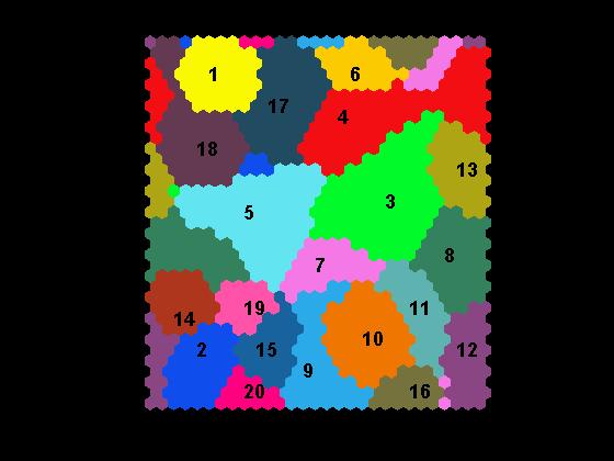
10 U-Matrix & K-means2 20 clusters QUEST_all_geochem_levelled_17Apr2009plk_sjf1_35x29_toroid_Km2_20


11 Surficial Geology vs Samples Coded by SOM-derived K-means (20 clusters) Surficial Geology SOM-derived K-means
12 CSIRO K-means Cluster Normalized Elemental Maps
13 Component Plots for each of the 42 elements

14 Cluster-Normalized Elemental Maps Au example Maps for each element available from GBC web site
15 CSIRO Component Plot - Element Distributions
16 Au Component Plot Six groups of BMU's are identified as anomalous in gold These BMU's are selected, and then samples from that BMU are plotted on a map.

17 Sample Sites & Au Component Plot Between Prince George and Quesnel & Mt Polley /Gibraltar

18 Group 1 of the Anomalous Au BMUs spatially plot between Prince George and Quesnel & Mt Polley /Gibraltar
19 Group 2 of the Anomalous Au BMUs

20 Group 3 of the Anomalous Au BMUs
21 Group 4 of the Anomalous Au BMUs

22 Group 5 of the Anomalous Au BMUs
23 Group 6 of the Anomalous Au BMUs Plots around Mt. Milligan
24 CSIRO Cross-plots of Selected Elements

25 Cross-Plot of Au vs Ag SOM Node values Three elevated Au associations evident QUEST_all_geochem_levelled_17Apr2009plk_sjf1_35x29_toroid_Km2_20


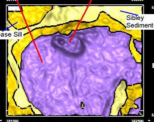
26 Spatial Distribution of Selected Ag vs Au Samples High Au
27 Brownfields Regional Geochemical Database -Osborne SOM used to identify populations related to processes SOM used to identify prospective targets Bruce Dickson, Peter Kowalczyk, Gary Sparks ~ 40,000 located (XYZ) geochemical samples with up to 13 elements assayed: ~ 60% of data base is empty CSIRO
 of data is missing.")
28 Exploration around the Osborne Cu-Au Deposit, Queensland, Australia. A Demonstration of SOM where a large fraction (60%) of data is missing. CSIRO


29 Component Plots CSIRO Component Plots #1
30 SOM Node - Depth Plot Z 260 AUPM vs depth AUPM Au Vs Depth CSIRO

31 SOM Node - Depth Plot Z 260 AUPM vs depth Detrital Basement/Cover Interface AUPM Au Vs Depth CSIRO SOM can assist in the identification of process

32 Au group I: Detrital Houdini Au component map Kultho r Osborne CSIRO


33 CSIRO Au All Looking ---- North
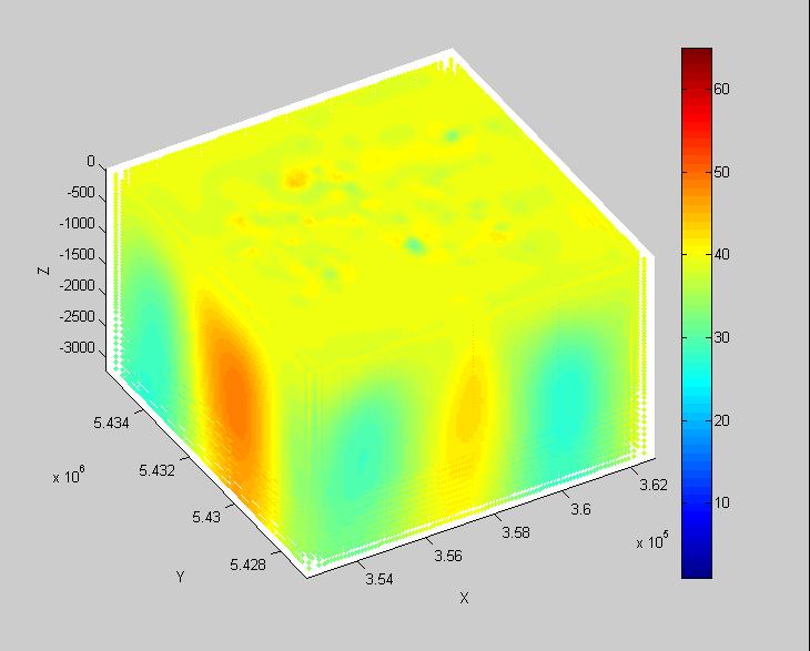
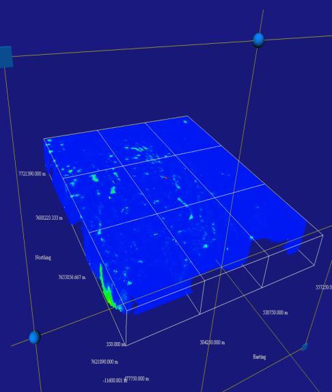
34 SOM on Voxel Volumes of Petrophysical Data resulting from Unconstrained Geophysical Inversion Seagull (PGE-Ni-Cu) Geophysical Model Data from: Magnetic and Gravity Three-Dimensional (3D) Modelling: Lake Nipigon Region Geoscience Initiative L.E. Reed, D.R.B. Rainsford CSIRO Ontario Ministry of Northern Development and Mines, Ontario Geological Survey MRD report


35 Seagull Location Lake Nipigon Seagull CSIRO Seagull Location of Seagull and other magnetic models in area [from Magnetic and Gravity Three-Dimensional (3D) Modelling: Lake Nipigon, Region Geoscience Initiative, L.E. Reed, D.R.B. Rainsford, Ontario, Ministry of Northern Development and Mines, Ontario Geological Survey, MRD report 193, 2006]
 Modelling: Lake Nipigon, Region Geoscience Initiative, L.E. Reed, D.R.B.")
36 Geology draped over Magnetics TMI CSIRO Magnetic model for Seagull. Overhead view of geology draped on amplitude enhanced total field magnetics. [from Magnetic and Gravity Three-Dimensional (3D) Modelling: Lake Nipigon, Region Geoscience Initiative, L.E. Reed, D.R.B. Rainsford, Ontario, Ministry of Northern Development and Mines, Ontario Geological Survey, MRD report 193, 2006]

37 Raw Data Magnetic Susceptibility Density CSIRO
38 SOM on 411,156 samples each: MagSus and Density sf10k_sus_den_12x9_toroid_2_km2_9 CSIRO


39 SOM on 411,156 samples: MagSus and Density CSIRO sf10k_sus_den_12x9_toroid_2_km2_9
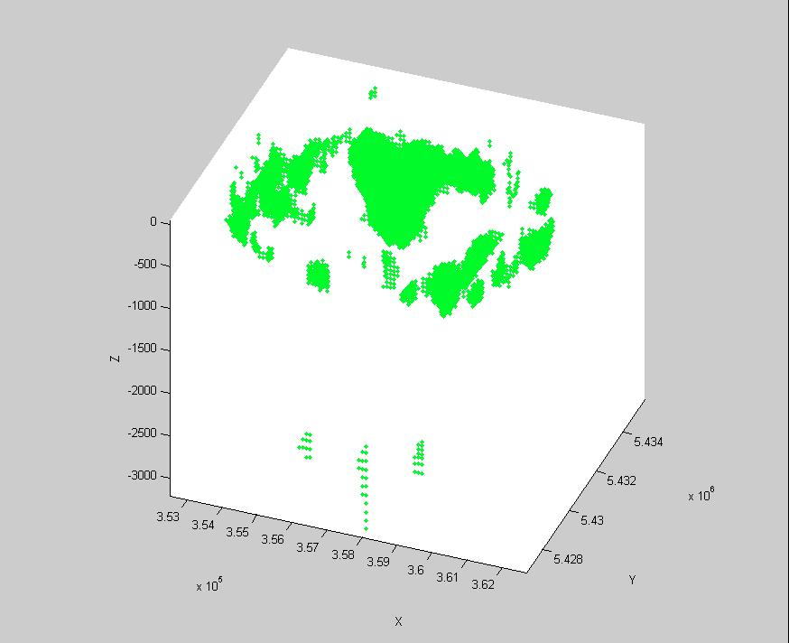
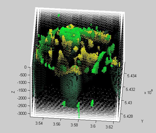
40 CSIRO sf10k_sus_den_12x9_toroid_2_km2_9
41 Outlier Analysis Based on measures of how far away a sample is from its SOM Code Vector - QER a b Var C c CSIRO

42 X-Y Plot Quantization Errors CSIRO
43 X-Y Plot Quantization Errors CSIRO
44 X-Y Plot Quantization Errors CSIRO
45 X-Y Plot Quantization Errors CSIRO
46 X-Y Plot Quantization Errors CSIRO
47 X-Y Plot Quantization Errors CSIRO
48 X-Y Plot Quantization Errors CSIRO

49 X-Y Plot Quantization Errors CSIRO
50 X-Y Plot Quantization Errors CSIRO
51 X-Y Plot Quantization Errors CSIRO

52 X-Z Plot Quantization Errors CSIRO
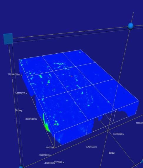
53 SOM on Voxel Volumes of Petrophysical Data resulting from Unconstrained Geophysical Inversion SiroSOM Analysis of UBC-Inverted Geophysical Voxel Data in the Mt Isa Region for Geological Survey of Queensland. Jane H Hodgkinson, Stephen J Fraser January-February 2009 gravgrd to mag list no negs_35x30_toroidkm2_5 CSIRO


54 Location and Input Data Sets Grav Grav Mag Mag CSIRO.


55 U-Matrix and K-means 5 Classes CSIRO.
56 Block Perspectives looking towards North BMUs Clusters Q-errors Grav Mag CSIRO.
57 Block Perspectives looking towards North BMUs Clusters Q-errors Grav Mag CSIRO.


58 Block Perspectives looking towards North BMUs Clusters Q-errors Grav Mag CSIRO.


59 BMUs Clusters Q-errors Grav Mag CSIRO.


60 BMUs Clusters Q-errors Grav Mag CSIRO.
61 BMUs Clusters Q-errors Grav Mag CSIRO.


62 BMUs Clusters Q-errors Grav Mag CSIRO.


63 BMUs Clusters Q-errors Grav Mag CSIRO.


64 BMUs Clusters Q-errors Grav Mag CSIRO.
65 BMUs Clusters Q-errors Grav Mag CSIRO.

66 BMUs Clusters Q-errors Grav Mag CSIRO.
67 BMUs Clusters Q-errors Grav Mag CSIRO.
68 BMUs Clusters Q-errors Grav Mag CSIRO.
69 BMUs Clusters Q-errors Grav Mag CSIRO.
70 BMUs Clusters Q-errors Grav Mag CSIRO.


71 BMUs Clusters Q-errors Grav Mag CSIRO.
72 BMUs Clusters Q-errors Grav Mag CSIRO.


73 BMUs Clusters Q-errors Grav Mag CSIRO.

74 BMUs Clusters Q-errors Grav Mag CSIRO.
75 Conclusions SOM sub-populations can show process or allow targeting of samples with specific characteristics; SOM can assist in identifying: stream and lake sediment geochemical targets; targets and domains in petrophysical volumes. Complex and diverse data types can be analyzed using SOM; Geochemical, Geophysical, Mineralogical (Geotechnical, Geometallurgical.) Any spatial data with complex or disparate inputs
Application and Challenges of Artificial Intelligence in Exploration
 Application and Challenges of Artificial Intelligence in Exploration XPLOR 2017 John McGaughey 2017 Mira Geoscience Ltd. Artificial Intelligence Artificial Intelligence is colossally hyped these days,
Resource Management through Machine Learning
 Resource Management through Machine Learning Justin Granek Eldad Haber* Elliot Holtham University of British Columbia University of British Columbia NEXT Exploration Inc Vancouver, BC V6T 1Z4 Vancouver,
Man, Machine and Data: A Mineral Exploration Perspective
 Man, Machine and Data: A Mineral Exploration Perspective Eun-Jung Holden, Geodata Algorithms Team The Centre for Exploration Targeting, School of Earth Sciences The University of Western Australia Team
Quantitative Magnetization Vector Inversion
 Quantitative Magnetization Vector Inversion I. N. MacLeod, R. G. Ellis 1. Geosoft Inc., Canada, ian.macleod@geosoft.com 2. Geosoft Inc., Canada, robert.ellis@geosoft.com BIOGRAPHY Ian MacLeod (BSc, Geology,
Prospectors Making NEW Discoveries
 Prospectors Making NEW Discoveries Hans Smit Minerals North 2012 Burns Lake, British Columbia May 2012 BC Needs New Discoveries BC mines and most advanced mineral projects were found decades ago To ensure
Processing Stream Sediment Geochemical Data for Geology and Dilution: An Example from Northern Vancouver Island
 Processing Stream Sediment Geochemical Data for Geology and Dilution: An Example from Northern Vancouver Island Dennis Arne, PGeo (BC), RPGeo (AIG), Principal Consultant Geochemistry, CSA Global Yao Cui,
Data Mining. 3.6 Regression Analysis. Fall Instructor: Dr. Masoud Yaghini. Numeric Prediction
 Data Mining 3.6 Regression Analysis Fall 2008 Instructor: Dr. Masoud Yaghini Outline Introduction Straight-Line Linear Regression Multiple Linear Regression Other Regression Models References Introduction
Iron Ore Rock Recognition Trials
 Australian Centre for Field Robotics A Key Centre of Teaching and Research The Rose Street Building J04 The University of Sydney 2006 NSW, Australia Iron Ore Rock Recognition Trials Fabio Ramos, Peter
Geochemical Data Evaluation and Interpretation
 Geochemical Data Evaluation and Interpretation Eric Grunsky Geological Survey of Canada Workshop 2: Exploration Geochemistry Basic Principles & Concepts Exploration 07 8-Sep-2007 Outline What is geochemical
Improvements on 2D modelling with 3D spatial data: Tin prospectivity of Khartoum, Queensland, Australia
 Improvements on 2D modelling with 3D spatial data: Tin prospectivity of Khartoum, Queensland, Australia C. E. Payne, F. W. Cunningham, A. J. Wilkins & G. A. Partington Kenex Ltd. Outline Prospectivity
MPM Online Tool ArcSDM 5 Final Seminar May 4 th 2018, Rovaniemi
 http://gtkdata.gtk.fi/mpm/ ArcSDM 5 Final Seminar May 4 th 2018, Rovaniemi Funding 2 Vesa Nykänen/ArcSDM5 Seminar 4.5. 2018 http://gtkdata.gtk.fi/mpm/ 3 Vesa Nykänen/ArcSDM5 Seminar 4.5. 2018 http://gtkdata.gtk.fi/mpm/
3D quantitative mineral potential targeting in the Kristineberg mining area, Sweden
 3D quantitative mineral potential targeting in the Kristineberg mining area, Sweden Tobias Hermansson, PhD Structural Geology Specialist Field Exploration North Fennoscandia Boliden Mines Outline Introduction
ECE 521. Lecture 11 (not on midterm material) 13 February K-means clustering, Dimensionality reduction
 13 February K-means clustering, Dimensionality reduction") ECE 521 Lecture 11 (not on midterm material) 13 February 2017 K-means clustering, Dimensionality reduction With thanks to Ruslan Salakhutdinov for an earlier version of the slides Overview K-means clustering
ECE 521 Lecture 11 (not on midterm material) 13 February 2017 K-means clustering, Dimensionality reduction With thanks to Ruslan Salakhutdinov for an earlier version of the slides Overview K-means clustering
Applying Artificial Neural Networks to problems in Geology. Ben MacDonell
 Applying Artificial Neural Networks to problems in Geology Ben MacDonell Artificial neural networks: a new method for mineral prospectivity mapping Training an ANN on geological data to predict parts of
GEOCHEMISTRY UNIFORM SYLLABUS
 GEOCHEMISTRY UNIFORM SYLLABUS The Association of Professional Engineers and Geoscientists of the Province of British Columbia Note: 1. This Syllabus May Be Subject To Change 2. These Courses Are Required
Jae-Bong Lee 1 and Bernard A. Megrey 2. International Symposium on Climate Change Effects on Fish and Fisheries
 International Symposium on Climate Change Effects on Fish and Fisheries On the utility of self-organizing maps (SOM) and k-means clustering to characterize and compare low frequency spatial and temporal
Mineral Discoveries Using Big Data Analytics: Azimut s Exploration Edge
 Mineral Discoveries Using Big Data Analytics: Azimut s Exploration Edge Jean-Marc Lulin, PhD, P.Geo. Sprott Natural Resource Symposium July 2017 Azimut: Big Data Analytics in Exploration 1) Why use Big
2017 Fowler Domain & Western Gawler Craton SkyTEM 312 AEM Survey, South Australia
 2017 Fowler Domain & Western Gawler Craton SkyTEM 312 AEM Survey, South Australia Geoscience Australia & the Geological Survey of South Australia D.J McInnes Geoscience Australia ecat ID 121550 Department
Geological control in 3D stratigraphic modeling, Oak Ridges Moraine, southern Ontario. Logan, C., Russell, H. A. J., and Sharpe, D. R.
 Geological control in 3D stratigraphic modeling, Oak Ridges Moraine, southern Ontario Logan, C., Russell, H. A. J., and Sharpe, D. R. Rationale Increasing urbanization in the Greater Toronto Area is creating
Cluster and outlier analysis applications in minerals exploration
 Cluster and outlier analysis applications in minerals exploration OZRI 2015, Melbourne Australia www.statedevelopment.sa.gov.au Cluster and outlier analysis applications in minerals exploration Laz Katona
MACHINE LEARNING FOR GEOLOGICAL MAPPING: ALGORITHMS AND APPLICATIONS
 MACHINE LEARNING FOR GEOLOGICAL MAPPING: ALGORITHMS AND APPLICATIONS MATTHEW J. CRACKNELL BSc (Hons) ARC Centre of Excellence in Ore Deposits (CODES) School of Physical Sciences (Earth Sciences) Submitted
The Geological Potential of Central America and the Caribbean: A USGS Report
 The Geological Potential of Central America and the Caribbean: A USGS Report World Bank Workshop Recent Developments in Mining and Sustainable Development in Latin America March 5, 2014 Jane Hammarstrom
CPSC 340: Machine Learning and Data Mining. Linear Least Squares Fall 2016
 CPSC 340: Machine Learning and Data Mining Linear Least Squares Fall 2016 Assignment 2 is due Friday: Admin You should already be started! 1 late day to hand it in on Wednesday, 2 for Friday, 3 for next
CAMBRIDGE NICKEL PROSPECT EXPLORATION UPDATE. XRF analysis of reconnaissance drill holes at Cambridge has been completed
 17 December 2012 CAMBRIDGE NICKEL PROSPECT EXPLORATION UPDATE HIGHLIGHTS XRF analysis of reconnaissance drill holes at Cambridge has been completed Initial geological logging and XRF analysis identifies
Contents 1 Introduction 2 Statistical Tools and Concepts
 1 Introduction... 1 1.1 Objectives and Approach... 1 1.2 Scope of Resource Modeling... 2 1.3 Critical Aspects... 2 1.3.1 Data Assembly and Data Quality... 2 1.3.2 Geologic Model and Definition of Estimation
Spatial Data Modelling: The Search For Gold In Otago. Presented By Matthew Hill Kenex Knowledge Systems (NZ) Kenex. Kenex
 Kenex. Kenex") Spatial Data Modelling: The Search For Gold In Otago Presented By Matthew Hill Knowledge Systems (NZ) Acknowledgements Michelle Stokes & Greg Partington - Pty Ltd (Australia) Paul Matthews, Charlene Wildman,
Spatial Data Modelling: The Search For Gold In Otago Presented By Matthew Hill Knowledge Systems (NZ) Acknowledgements Michelle Stokes & Greg Partington - Pty Ltd (Australia) Paul Matthews, Charlene Wildman,
Integrated Presentation and Interpretation of Geochemical Data and Multi-disciplinary Information: Regional and Local-Scale Approaches
 Integrated Presentation and Interpretation of Geochemical Data and Multi-disciplinary Information: Regional and Local-Scale Approaches Greg M. Hollyer 1, Tracey Minton 2 and Andrew Daniels 3 Today s geoscientists
For personal use only
 ASX ANNOUNCEMENT ASX: WIN 16 January 2014 Six- Month Work Programme For Immediate Release Programme CORPORATE DIRECTORY Non Executive Chairman George Cameron- Dow Managing Director & CEO David J Frances
MINERAL EXPLORATION UNDER DEEP COVER. Neil Williams School of Earth & Environmental Sciences
 MINERAL EXPLORATION UNDER DEEP COVER Neil Williams School of Earth & Environmental Sciences The problem Discovery rates, especially of world-class deposits, have fallen significantly over the past 15-20
USING EXISTING, PUBLICLY-AVAILABLE DATA TO GENERATE NEW EXPLORATION PROJECTS
 USING EXISTING, PUBLICLY-AVAILABLE DATA TO GENERATE NEW EXPLORATION PROJECTS Philip M. Baker 1, Paul A. Agnew 2 and M. Hooper 1 1 Rio Tinto Exploration, 37 Belmont Ave, Belmont WA 6104. Australia 2 Rio
Statistical Rock Physics
 Statistical - Introduction Book review 3.1-3.3 Min Sun March. 13, 2009 Outline. What is Statistical. Why we need Statistical. How Statistical works Statistical Rock physics Information theory Statistics
ROBERTO BATTITI, MAURO BRUNATO. The LION Way: Machine Learning plus Intelligent Optimization. LIONlab, University of Trento, Italy, Apr 2015
 ROBERTO BATTITI, MAURO BRUNATO. The LION Way: Machine Learning plus Intelligent Optimization. LIONlab, University of Trento, Italy, Apr 2015 http://intelligentoptimization.org/lionbook Roberto Battiti
Condor Blanco Mines Limited (Code: CDB) Company Presentation Devil s Creek Tenement E70/4529
 Company Presentation Devil s Creek Tenement E70/4529") Condor Blanco Mines Limited (Code: CDB) Company Presentation Devil s Creek Tenement E70/4529 Disclaimer This document is not a disclosure document nor does it constitute the provision of financial product
Condor Blanco Mines Limited (Code: CDB) Company Presentation Devil s Creek Tenement E70/4529 Disclaimer This document is not a disclosure document nor does it constitute the provision of financial product
Prospectivity Modelling of Granite-Related Nickel Deposits Throughout Eastern Australia
 Prospectivity Modelling of Granite-Related Nickel Deposits Throughout Eastern Australia M P Hill 1 and A McCarthy 2 ABSTRACT Spatial modelling has been used to determine potential locations of granite-related
Introduction. Geoscience BC 2012 Projects McLeod Lake Sample Reanalysis by INAA
 Updating the British Columbia Regional Geochemical Survey Database with New Field Survey and Sample Reanalysis Data to Support Mineral Exploration (NTS 082F, K, 092K, L, 093J, 102I) W. Jackaman, Noble
ARTIFICIAL NEURAL NETWORKS گروه مطالعاتي 17 بهار 92
 ARTIFICIAL NEURAL NETWORKS گروه مطالعاتي 17 بهار 92 BIOLOGICAL INSPIRATIONS Some numbers The human brain contains about 10 billion nerve cells (neurons) Each neuron is connected to the others through 10000
PROANA A USEFUL SOFTWARE FOR TERRAIN ANALYSIS AND GEOENVIRONMENTAL APPLICATIONS STUDY CASE ON THE GEODYNAMIC EVOLUTION OF ARGOLIS PENINSULA, GREECE.
 PROANA A USEFUL SOFTWARE FOR TERRAIN ANALYSIS AND GEOENVIRONMENTAL APPLICATIONS STUDY CASE ON THE GEODYNAMIC EVOLUTION OF ARGOLIS PENINSULA, GREECE. Spyridoula Vassilopoulou * Institute of Cartography
Experimental Design and Data Analysis for Biologists
 Experimental Design and Data Analysis for Biologists Gerry P. Quinn Monash University Michael J. Keough University of Melbourne CAMBRIDGE UNIVERSITY PRESS Contents Preface page xv I I Introduction 1 1.1
Course in Data Science
 Course in Data Science About the Course: In this course you will get an introduction to the main tools and ideas which are required for Data Scientist/Business Analyst/Data Analyst. The course gives an
Text Mining. Dr. Yanjun Li. Associate Professor. Department of Computer and Information Sciences Fordham University
 Text Mining Dr. Yanjun Li Associate Professor Department of Computer and Information Sciences Fordham University Outline Introduction: Data Mining Part One: Text Mining Part Two: Preprocessing Text Data
Unsupervised Anomaly Detection for High Dimensional Data
 Unsupervised Anomaly Detection for High Dimensional Data Department of Mathematics, Rowan University. July 19th, 2013 International Workshop in Sequential Methodologies (IWSM-2013) Outline of Talk Motivation
Final Overview. Introduction to ML. Marek Petrik 4/25/2017
 Final Overview Introduction to ML Marek Petrik 4/25/2017 This Course: Introduction to Machine Learning Build a foundation for practice and research in ML Basic machine learning concepts: max likelihood,
Outline Brief Overview MapPlace Website Data Delivery & Map Themes Digital Geology
 BRITISH COLUMBIA GEOLOGICAL SURVEY Kirk Hancock Pat Desjardins Nick Massey BRITISH COLUMBIA Ministry of Energy and Mines Ward Kilby acknowledged developer of MapPlace Outline Brief Overview MapPlace Website
Placer Potential Map. Dawson L and U se P lan. Jeffrey Bond. Yukon Geological Survey
 Placer Potential Map Dawson L and U se P lan By Jeffrey Bond Yukon Geological Survey Dawson Land Use Plan Placer Potential Map 1.0 Introduction Placer mining has been an important economic driver within
Mineral Systems and Exploration Targeting. T. Campbell McCuaig - Centre for Exploration Targeting
 Mineral Systems and Exploration Targeting T. Campbell McCuaig - Centre for Exploration Targeting Mineral Geoscience Masters October 2013 Premise Exploration is an exercise in sequential volume reduction,
Advanced analysis and modelling tools for spatial environmental data. Case study: indoor radon data in Switzerland
 EnviroInfo 2004 (Geneva) Sh@ring EnviroInfo 2004 Advanced analysis and modelling tools for spatial environmental data. Case study: indoor radon data in Switzerland Mikhail Kanevski 1, Michel Maignan 1
Computational Genomics
 Computational Genomics http://www.cs.cmu.edu/~02710 Introduction to probability, statistics and algorithms (brief) intro to probability Basic notations Random variable - referring to an element / event
BCGQ Mission Statement. Acquire new geoscientific knowledge in Québec within a sustainable development perspective of our mineral resources.
 BCGQ Mission Statement Acquire new geoscientific knowledge in Québec within a sustainable development perspective of our mineral resources. Financial Resources Natural Resources Fund, Mining Heritage Section
3D Modeling for exploration
 3D Modeling for exploration Tero Niiranen Acting Division Manager Bedrock and Resources, GTK Rovaniemi office 02.05.2014 1 3D modeling supporting exploration in GTK Visualizing data in 3D world 3D geophysical
CHAMPION BEAR RESOURCES
 CHAMPION BEAR RESOURCES EXPLORING ADVANCED STAGE PRECIOUS METAL PROPERTIES IN ONTARIO Exploration Update January 2011 Forward Looking Statements This exploration update contains forward looking statements
Report. On a 3D Magnetic Inversion. For. Cadillac Ventures Ltd. And. Newcastle Minerals Ltd. Pickle Lake Project. Ontario, Canada
 Report On a 3D Magnetic Inversion For Cadillac Ventures Ltd And Newcastle Minerals Ltd. Pickle Lake Project Ontario, Canada SCOTT HOGG & ASSOCIATES LTD October 2010 TABLE OF CONTENTS 1 INTRODUCTION...
NT RESOURCES LIMITED QUARTERLY ACTIVITIES REPORT FOR THE PERIOD ENDED 30 JUNE 2010 ASX CODE: NTR
 NT RESOURCES LIMITED QUARTERLY ACTIVITIES REPORT FOR THE PERIOD ENDED 30 JUNE 2010 ASX CODE: NTR Activities Report Background NT Resources Limited ( NT Resources or the Company ) holds six granted Exploration
Our Services. What We Do. How We Can Help. Contact us today: January (0)
") Listening and Understanding to Optimize our Efficiency Our Experience and Knowledge to Work for You Tailor-made Solutions to Meet your Needs Our Challenge is You Success What We Do Our Services GeoViz
Listening and Understanding to Optimize our Efficiency Our Experience and Knowledge to Work for You Tailor-made Solutions to Meet your Needs Our Challenge is You Success What We Do Our Services GeoViz
Richard Poulden, Executive Chairman of Wishbone Gold said:
 Wishbone Gold Plc / Index: AIM / Epic: WSBN / Sector: Natural Resources 17 July 2013 Wishbone Gold Plc ( Wishbone Gold or the Company ) Positive Exploration Update on Hanging Valley Prospect, Wishbone
Magnetic Case Study: Raglan Mine Laura Davis May 24, 2006
 Magnetic Case Study: Raglan Mine Laura Davis May 24, 2006 Research Objectives The objective of this study was to test the tools available in EMIGMA (PetRos Eikon) for their utility in analyzing magnetic
CHANGES TO THE GEOLOGY & GEOPHYSICS PROGRAMS FOR
 CHANGES TO THE GEOLOGY & GEOPHYSICS PROGRAMS FOR 2018 19 For 2018 19, the changes are: (a) Geology 435 or Geology 441, geology and hydrogeology field courses, respectively, are added as required courses
Review of Lecture 1. Across records. Within records. Classification, Clustering, Outlier detection. Associations
 Review of Lecture 1 This course is about finding novel actionable patterns in data. We can divide data mining algorithms (and the patterns they find) into five groups Across records Classification, Clustering,
NOTES ON THE RESPONSE OF THE PECORS MAGNETIC ANOMALY
 L.E. Reed Geophysical Consultant Inc. 11331 Fourth Line Nassagaweya R.R. 2 Rockwood, Ont. N0B 2K0, Canada PHONE:905 854 0438 FAX: 905 854 1355 E-mail: lereed@aztec-net.com NOTES ON THE RESPONSE OF THE
Mt. Isa Georgina Basin Phosphate Assets Presentation
 MEDIA RELEASE For Immediate Release 30 November 2010 Mt. Isa Georgina Basin Phosphate Assets Presentation Following the recent announcements in respect of the acquisition of the Duyfken Minerals portfolio,
For personal use only
 ASX ANNOUNCEMENT ACN 123 567 073 3 July 2014 NEW FRASER RANGE PROJECT AREA AT KITCHENER New 100%-owned exploration licence application covers 203km 2, situated on the Fraser Range Gravity High Enterprise
NEWS RELEASE FOR IMMEDIATE RELEASE: MARCH 5, 2018
 NEWS RELEASE FOR IMMEDIATE RELEASE: MARCH 5, 2018 Eskay Mining provides update on ongoing geological review - Targeting E&L-Type Nickel-Copper-PGE and Eskay-Type VMS Potential on Its Golden Triangle Holdings:
CLUe Training An Introduction to Machine Learning in R with an example from handwritten digit recognition
 CLUe Training An Introduction to Machine Learning in R with an example from handwritten digit recognition Ad Feelders Universiteit Utrecht Department of Information and Computing Sciences Algorithmic Data
Artificial neural networks as a tool for mineral potential mapping with GIS
 INT. J. REMOTE SENSING, 2003, VOL. 24, NO. 5, 1151 1156 Artificial neural networks as a tool for mineral potential mapping with GIS J. P. RIGOL-SANCHEZ Department of Geology, University of Jaen, 23071,
Drilling Program Commences on Iron Oxide Copper Gold Targets
 3 June 2008 Manager Company Announcements Company Announcements Office Australian Stock Exchange Limited Level 10, 20 Bond Street SYDNEY NSW 2000 ABN 42 082 593 235 Electronic delivery No of pages: 6 Drilling
Main Menu. Douglas Oldenburg University of British Columbia Vancouver, BC, Canada
 Using ERA low frequency E-field profiling and UBC 3D frequency-domain inversion to delineate and discover a mineralized zone in Porcupine district, Ontario, Canada. Vlad Kaminski* University of British
Bayesian Networks Inference with Probabilistic Graphical Models
 4190.408 2016-Spring Bayesian Networks Inference with Probabilistic Graphical Models Byoung-Tak Zhang intelligence Lab Seoul National University 4190.408 Artificial (2016-Spring) 1 Machine Learning? Learning
For personal use only
 3 August 2015 Market Announcements Platform ASX Limited Exchange Centre, 20 Bridge Street Sydney NSW 2000 ASX Code: SEG DERALINYA PROJECT JOINT VENTURE Segue Resources Limited (Segue or the Company) is
Geology Geologists and Prospectors
 Geology Geologists and Prospectors David Lefebure and JoAnne Nelson BC Geological Survey April 17, 2008 Ministry of Energy and Mines Geology - A type of Geoscience is the study of the Earth, the materials
Scuola di Calcolo Scientifico con MATLAB (SCSM) 2017 Palermo 31 Luglio - 4 Agosto 2017
 2017 Palermo 31 Luglio - 4 Agosto 2017") Scuola di Calcolo Scientifico con MATLAB (SCSM) 2017 Palermo 31 Luglio - 4 Agosto 2017 www.u4learn.it Ing. Giuseppe La Tona Sommario Machine Learning definition Machine Learning Problems Artificial Neural
Scuola di Calcolo Scientifico con MATLAB (SCSM) 2017 Palermo 31 Luglio - 4 Agosto 2017 www.u4learn.it Ing. Giuseppe La Tona Sommario Machine Learning definition Machine Learning Problems Artificial Neural
From statistics to data science. BAE 815 (Fall 2017) Dr. Zifei Liu
 Dr. Zifei Liu") From statistics to data science BAE 815 (Fall 2017) Dr. Zifei Liu Zifeiliu@ksu.edu Why? How? What? How much? How many? Individual facts (quantities, characters, or symbols) The Data-Information-Knowledge-Wisdom
From statistics to data science BAE 815 (Fall 2017) Dr. Zifei Liu Zifeiliu@ksu.edu Why? How? What? How much? How many? Individual facts (quantities, characters, or symbols) The Data-Information-Knowledge-Wisdom
Presentation given to computer science undergraduate students at the University of Houston July 2007
 Presentation given to computer science undergraduate students at the University of Houston July 2007 Machine Learning and Data Mining in Mars Tomasz F. Stepinski Lunar and Planetary Institute MARS/EARTH
Introduction to Geology and Geometallurgy
 Introduction to Geology and Geometallurgy Improving Resource Knowledge to Optimise Minerals Processing: Part 1 Mark Noppe mnoppe@srk.com.au 24 May 2018 1 Why Geology? Improving resource knowledge Rocks
Advances in Seismic Reflection as an Exploration Tool in Hard-Rock Mining
 Advances in Seismic Reflection as an Exploration Tool in Hard-Rock Mining Greg Turner 28 February 2018, Brisbane, Qld, Australia The last 10 years Status 2007 Applied research and surveys led by Curtin
Geosciences Data Digitize and Materialize, Standardization Based on Logical Inter- Domain Relationships GeoDMS
 Geosciences Data Digitize and Materialize, Standardization Based on Logical Inter- Domain Relationships GeoDMS Somayeh Veiseh Iran, Corresponding author: Geological Survey of Iran, Azadi Sq, Meraj St,
Magnetics: Fundamentals and Parameter Extraction
 : Fundamentals and Parameter Extraction Stephen Billings Magnetic module outline fundamentals Sensor systems Data examples and demo Parameter extraction Concepts Real-world examples Classification Using
What have we learned from the Case Histories
 What have we learned from the Case Histories Earth materials have a range of physical properties. Application of geophysics is carried out in a 7 Step process. Physical property of the target must be different
CHANGES TO THE GEOLOGY & GEOPHYSICS PROGRAMS FOR March 15, 2017
 CHANGES TO THE GEOLOGY & GEOPHYSICS PROGRAMS FOR 2017 18 March 15, 2017 For 2017 18, the changes are: (a) Students in the Honours programs in Geology will be allowed to take either Geology 509 (Independent
Developments in Geochemical Data Processing and Presentation: Some Useful Tools for Evaluating Multi-element
 Developments in Geochemical Data Processing and Presentation: Some Useful Tools for Evaluating Multi-element Geochemical Data Eric Grunsky Geological Survey of Canada International Geochemical Exploration
QUATERNARY GEOLOGY STUDIES IN CENTRAL MELVILLE PENINSULA, NUNAVUT
 QUATERNARY GEOLOGY STUDIES IN CENTRAL MELVILLE PENINSULA, NUNAVUT Tremblay, T. 1, Paulen, R. 2 and Corrigan, D. 2 (1) Canada-Nunavut Geoscience Office, Iqaluit, NU (2) Geological Survey of Canada, Ottawa,
Uranium Exploration in North West Manitoba
 CanAlaska Uranium Ltd. Uranium Exploration in North West Manitoba Ross Polutnik K. Schimann, R. Duff, S. Napier Manitoba Mining and Minerals Convention: Nov 15-17, 2012 1 NW Manitoba Project: Outline Project
2) the identification through recent mapping of a Brucejack-style conceptual exploration target on its North Mitchell block; and
 the identification through recent mapping of a Brucejack-style conceptual exploration target on its North Mitchell block; and") NEWS RELEASE FOR IMMEDIATE RELEASE: JANUARY 19, 2018 Eskay Mining Corp. Announces 2018 Plans: Ni-Cu-Co Potential Along Red Lightning Trend toward Garibaldi s E&L Occurrence; Potential for Brucejack-Style
NEWS RELEASE FOR IMMEDIATE RELEASE: JANUARY 19, 2018 Eskay Mining Corp. Announces 2018 Plans: Ni-Cu-Co Potential Along Red Lightning Trend toward Garibaldi s E&L Occurrence; Potential for Brucejack-Style
Data Mining Classification: Basic Concepts and Techniques. Lecture Notes for Chapter 3. Introduction to Data Mining, 2nd Edition
 Data Mining Classification: Basic Concepts and Techniques Lecture Notes for Chapter 3 by Tan, Steinbach, Karpatne, Kumar 1 Classification: Definition Given a collection of records (training set ) Each
Stratimagic. Seismic Facies Classification
 Stratimagic Seismic Facies Classification 1 Stratimagic A truly geological interpretation of seismic data Stratimagic seismic facies maps allow geoscientists to rapidly gain insight into the depositional
Discovery Through Situational Awareness
 Discovery Through Situational Awareness BRETT AMIDAN JIM FOLLUM NICK BETZSOLD TIM YIN (UNIVERSITY OF WYOMING) SHIKHAR PANDEY (WASHINGTON STATE UNIVERSITY) Pacific Northwest National Laboratory February
EXPLORATION TO PRODUCTION: OPTIMIZING THE ALGOLD TIJIRIT PROJECT THROUGH EXPERT GEOLOGICAL SERVICES
 EXPLORATION TO PRODUCTION: OPTIMIZING THE ALGOLD TIJIRIT PROJECT THROUGH EXPERT GEOLOGICAL SERVICES MineAfrica 2018 Marc-Antoine Laporte, M.Sc., P.Geo. Global Project Geologist WHO IS SGS 2 SGS MINERALS
Evaluating the information content of National ASTER Geoscience Maps in the Wagga Wagga and Cobar regions of New South Wales
 Evaluating the information content of National ASTER Geoscience Maps in the Wagga Wagga and Cobar regions of New South Wales The National ASTER Geoscience Maps, freely available from CSIRO/GA (https://data.csiro.au/dap/
Machine Learning Overview
 Machine Learning Overview Sargur N. Srihari University at Buffalo, State University of New York USA 1 Outline 1. What is Machine Learning (ML)? 2. Types of Information Processing Problems Solved 1. Regression
BUILDING 3D MODEL OF ROCK QUALITY DESIGNATION ASSISTED BY CO-OPERATIVE INVERSION OF SEISMIC AND BOREHOLE DATA
 BUILDING 3D MODEL OF ROCK QUALITY DESIGNATION ASSISTED BY CO-OPERATIVE INVERSION OF SEISMIC AND BOREHOLE DATA 1 st Duy Thong Kieu 2 nd Anton Kepic* Curtin University and DET CRC Curtin University and DET
June 2017 Quarterly Report
 ASX ANNOUNCEMENT Date: 31 July 2017 June 2017 Quarterly Report Victory Mines Limited (ASX:VIC) ( Victory or the Company ) provides a review of its activities during the June 2017 quarter. Exploration Western
Statistical Evaluations in Exploration for Mineral Deposits
 Friedrich-Wilhelm Wellmer Statistical Evaluations in Exploration for Mineral Deposits Translated by D. Large With 120 Figures and 74 Tables Springer Preface The Most Important Notations and Abbreviations
Machine learning comes from Bayesian decision theory in statistics. There we want to minimize the expected value of the loss function.
 Bayesian learning: Machine learning comes from Bayesian decision theory in statistics. There we want to minimize the expected value of the loss function. Let y be the true label and y be the predicted
Article: Report on gravity analysis
 Article: Report on gravity analysis Brownfields exploration using constrained gravity inversions By Chris Wijns (First Quantum Minerals Ltd) and Daniel Core (Fathom Geophysics LLC) Summary Gravity measurements
Auxiliary Information in Geophysical Inversion
 Auxiliary Information in Geophysical Inversion Robert G. Ellis 1, Peter A. Diorio 2, Ian N. MacLeod 1 Abstract There are a number of critical auxiliary inputs to a geophysical inversion, apart from the
Data Mining. Preamble: Control Application. Industrial Researcher s Approach. Practitioner s Approach. Example. Example. Goal: Maintain T ~Td
 Data Mining Andrew Kusiak 2139 Seamans Center Iowa City, Iowa 52242-1527 Preamble: Control Application Goal: Maintain T ~Td Tel: 319-335 5934 Fax: 319-335 5669 andrew-kusiak@uiowa.edu http://www.icaen.uiowa.edu/~ankusiak
NEW PRODUCTS AND ADVANCEMENTS IN 3-D MODELLING PROTOCOLS BASED ON STUDIES IN THICK DRIFT AREAS IN ONTARIO, CANADA
 NEW PRODUCTS AND ADVANCEMENTS IN 3-D MODELLING PROTOCOLS BASED ON STUDIES IN THICK DRIFT AREAS IN ONTARIO, CANADA Abigail K. Burt and Andrew F. Bajc Ontario Geological Survey, 933 Ramsey Lake Road, Sudbury,
Machine Learning! in just a few minutes. Jan Peters Gerhard Neumann
 Machine Learning! in just a few minutes Jan Peters Gerhard Neumann 1 Purpose of this Lecture Foundations of machine learning tools for robotics We focus on regression methods and general principles Often
Basics of Multivariate Modelling and Data Analysis
 Basics of Multivariate Modelling and Data Analysis Kurt-Erik Häggblom 2. Overview of multivariate techniques 2.1 Different approaches to multivariate data analysis 2.2 Classification of multivariate techniques
 Three-Dimensional Computer-Based Gold Prospectivity Mapping using Conventional Geographic Information systems, Three- Dimensional Mine Visualization Software and Custom Built Spatial Analysis Tools Eduardo
Managing Director s Presentation
 2013 Annual General Meeting Managing Director s Presentation #1 Disclaimer and Competent Person s Statement The information in this presentation is published to inform you about Adelaide Resources Limited
Multivariate Statistics Summary and Comparison of Techniques. Multivariate Techniques
 Multivariate Statistics Summary and Comparison of Techniques P The key to multivariate statistics is understanding conceptually the relationship among techniques with regards to: < The kinds of problems