Social Geography for Mitigation: Developing Geo-narrative Media to Tell Your Client s Story
|
|
|
- Virginia Douglas
- 5 years ago
- Views:
Transcription

1 Social Geography for Mitigation: Developing Geo-narrative Media to Tell Your Client s Story Julie Urbanik, Ph.D. Federal Public Defender Training, KC, MO April 27, 2017
2 Social Geography? Don t we already knew where everything is? Don t we already use maps in mitigation? Are you going to give me a map test? Geography (the why of where) Physical Features Human Features Social Economic Political Nature Quantitative Data Qualitative Data How? Maps Case Studies Synthesize Context - place-based - comparative
3 Social Geography explores the ways people (as individuals and communities) experience identity, difference, and inequality impulse towards activism and social welfare applied 1. Mapping Social Conditions where and what is happening? (KCUR article) Quantitative Data Collection
4 Credit WCCPS University of Virginia


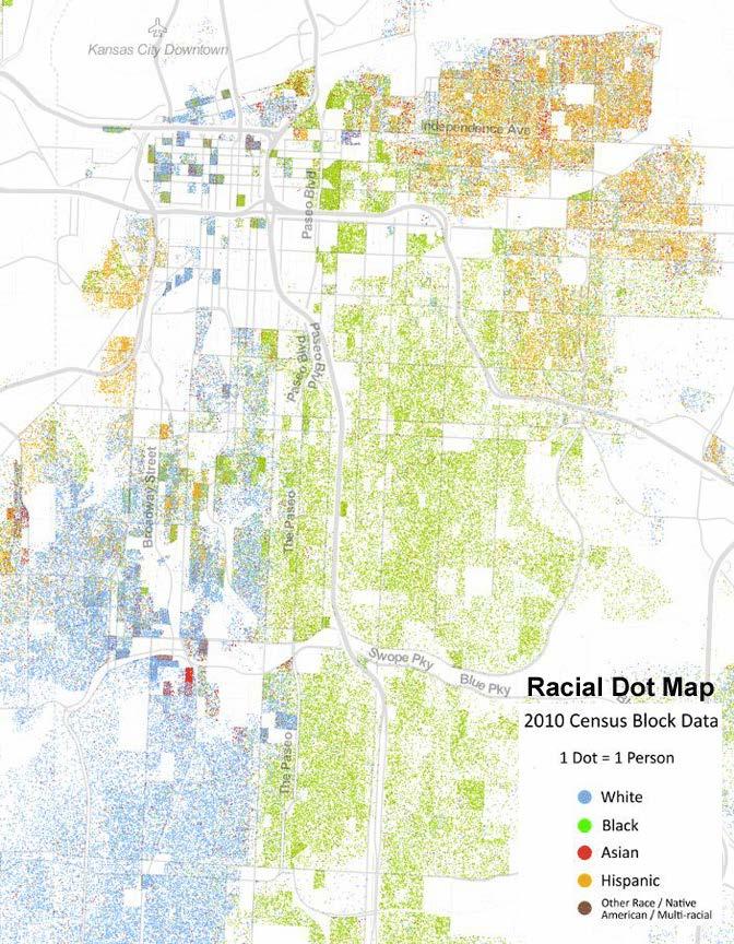
5 Credit US Census Bureau
6 Credit WCCPS University of Virginia
7 Social Geography explores the ways people (as individuals and communities) experience identity, difference, and inequality impulse towards social activism and welfare applied 1. Mapping Social Conditions where and what is happening? (KCUR article) Quantitative Data Collection 2. Understanding Categories of Social Difference Quantitative Data (e.g., Census) Qualitative Data (e.g., interviews, observation, primary sources)

8 Categories of Social Difference: Gender Race Ethnicity Income Education Nationality Technology Health Family Culture Sexuality Transportation
9 Social Geography explores the ways people (as individuals and communities) experience identity, difference, and inequality impulse towards activism and social welfare applied 1. Mapping Social Conditions where and what is happening? (KCUR article) Quantitative Data Collection 2. Understanding Categories of Social Difference Quantitative Data (e.g., Census) Qualitative Data (e.g., interviews, observation, primary sources) 3. Overlapping nature of difference, social conditions, and PLACES not exclusive! Negotiations made in everyday life as place, differences, and conditions intersect through the INDIVIDUAL

10
11 We are born into natural and cultural environments that may either demand our every effort to survive or give us space and scope to make choices and decisions of which others can only dream. Place, most emphatically place of birth but also the constricted space in which the majority of lives are lived, remains the most potent factor shaping the destiny of humans. - Harm De Blij The Power of Place


12 Mitigation Social Geography Life history investigation Maps and Facts Materials that humanize the client Life history must include placerelations Synthesize the social conditions, relevant categories of difference, and personal experience. Participatory methods generating humanizing media Step into someone s shoes Defense Social Geographer Client

13 Geo-Narrative Media What the social geographer produces Organizing (events/stories in places) into a meaningful narrative Defense Social Geographer Client Geo-narrative Aims produce knowledge specific to client forefront subjective and complex voice self-representation vs. authoritative Geo-narrative Methods personal maps/personal atlas body-mapping memory walks video, visuals, audio


14 Geo-Narrative Media: The Power of Geography We all have geographies The gulf that exists between us as people is that when we look at each other we might see faces, skin color, gender, race, or attitudes, but we don t see, we can t see, the geographies. And once we experience each other s geographies we realize that the things we see as dividing us are, all too often, illusions, falsehoods: that the borders between us are in truth not hard but porous. - paraphrased from Neil Gaiman
 Build relevant")

15 Geo-Narrative Media Defense Team life history (maps and facts) Build relevant media Needs of defense team Participatory methods with client/people Social Geography Analysis
 Life history: case history/incarceration troubled")


16 Geo-Narrative Media Case Study: U.S. v. Bryan Sheppard (Miller Case) Life history: case history/incarceration troubled family, learning disabilities, drug use Build relevant media: 10-minute Body Map video 5-minute Neighborhood video Needs of defense team: Bryan s story Neighborhood context Participatory work: 6-hour Body Map Interview with Bryan 3-hour Memory Walk with Deb Howard Social Geography Analysis: relevant categories of difference available visuals how to synthesize?
17 Geo-Narrative Media Case Study: U.S. v. Bryan Sheppard (Miller Case) Body Map: A visual and symbolic interpretation of an autobiography Goals: (a) to help Bryan prepare himself for mitigation hearing; (b) to show Bryan s ability to be self-reflective, to share how he sees his past and his future, (c) to provide a visually explanatory narrative that makes use of available life history materials 1 st 3-hour session brainstorm key life chapters, events, locations as he sees them provide an outline of his body and drawing materials help him develop symbols to represent key aspects of himself and his narrative 2 nd 3-hour session review and edit body map and then record audio of Bryan explaining his symbols ~ 90 minutes of audio was edited down to ten minutes Produce media combining body map, family photos, and relevant visual materials

18 Bryan s Body Map Personality Physical Appearance Personal Strengths Personal Hardships Support Systems Spirituality Life Stages Vision for Future
19 Bryan s Body Map Video Please click here to watch full 10-minute video Use password: Bryan
20 Geo-Narrative Media Case Study: U.S. v. Bryan Sheppard (Miller Case) Memory Walk: Generating memories/stories while moving through a place Goals: (a) to provide a view of Bryan (as a teenager) that was not heard during original trial; (b) to create a narrative that provides insight into the Marlborough neighborhood where Bryan spent the majority of his life 1 3-hour session driving/walking tour of key locations in Marlborough ~ 90 minutes of audio was collected and then edited down to 5 minutes ~ 30 minutes of video footage and still images were collected specific locations were based on life history information as well as sites provided by Deb Howard. Produce media combining memory walk footage, family photos, and relevant visual materials
21 Teenagers in Marlborough Video Please click here to watch full 5-minute video Use password: Deb
22 Geo-Narrative Media Case Study: U.S. v. Bryan Sheppard (Miller Case) Material was submitted as exhibits to the sentencing memorandum Process of creating the Body Map assisted defense in preparing Bryan for testifying Production of media made ample use of disparate life history materials by synthesizing them from a social geography perspective Value of Social Geographer and Geo-narrative Approach for Mitigation Cases 1)Assisting defense in synthesizing larger social conditions, specific categories of difference, and the client s experience of the identity and place nexus 2)Intermediary between the maps and facts of defense/mitigation specialists and the client s perspective giving client a voice 3) Humanizing the client for juries/judges: everyone has a personal geography challenging stereotypes of clients as only criminals helping to show that regardless of circumstance, client still has a real heart and future.
23 Social Geography for Mitigation: Developing Geo-narrative Media to Tell Your Client s Story Julie Urbanik, Ph.D. Federal Public Defender Training, KC, MO April 27, 2017
24 Resources Contact: De Blij, H The Power of Place: Geography, Destiny, and Globalization s Rough Landscape. New York: Oxford University Press. Del Casino, Jr., V Social Geography: A Critical Introduction. Malden, MA: Wiley-Blackwell. Gastaldo, D., Magalhães, L., Carrasco, C., and Davy, C. (2012). Body-Map Storytelling as Research: Methodological considerations for telling the stories of undocumented workers through body mapping. Retrieve PDF. Hein, J., J. Evans, & P. Jones. (2008) Mobile Methodologies: Theory, Technology and Practice. Geography Compass 2/5: Retrieve PDF. O Higgins, B Data Maps Show Troost As Racial, Economic, and Educational Divide. Kansas City: KCUR. URL Please click here to watch full Body Map video (Use password: Bryan) Please click here to watch full Neighborhood video (Use password: Deb)
+ DEEP. Credentials OLIVIER LA ROCCA
 DEEP Credentials OLIVIER LA ROCCA EUROPARTNERS What is Deep? How does it work? Case study AGENDA Contacts Understanding the reality and the nuances of local communities is crucial when it comes to take
Strand 1: Principles of Constitutional Democracy. Strand 2: Principles and Processes of Governance Systems
 Social Studies GLE S - Grade 4 Strand 1: Principles of Constitutional Democracy 1. Knowledge of the principles expressed in documents shaping constitutional democracy in the United States A. Knowledge
VIDEO: The World In A Box: Geographic Information Systems
 Geographic Information Systems VIDEO: The World In A Box: Geographic Information Systems Adapted from: The World In A Box: Geographic Information Systems. A Public Television Documentary, Opticus Corporation:
GIS AND COMMUNITY ENGAGEMENT: SOCIOSPATIAL APPROACHES TO RESEARCH AND POLICY
 GIS AND COMMUNITY ENGAGEMENT: SOCIOSPATIAL APPROACHES TO RESEARCH AND POLICY DR. SHEILA LAKSHMI STEINBERG BRANDMAN UNIVERSITY CHAPMAN UNIVERSITY SYSTEM GIS DAY PRESENTATION-UNIVERSITY OF KANSAS, NOVEMBER
POTENTIAL COURSES FOR CEP STUDENTS AND THEIR AREAS OF INTERST
 POTENTIAL COURSES FOR CEP STUDENTS AND THEIR AREAS OF INTERST C ENV 110 Food & Environment CHSTU 320 Food Sovereignty in Mexico and the United States ANTH 361 Anthropology of Food ANTH 488 Agroecology
WORLD GEOGRAPHY GRADE 10
 Parent / Student Course Information SOCIAL STUDIES WORLD GEOGRAPHY GRADE 10 Counselors are available to assist parents and students with course selections and career planning. Parents may arrange to meet
The Importance of Spatial Literacy
 The Importance of Spatial Literacy Dr. Michael Phoenix GIS Education Consultant Taiwan, 2009 What is Spatial Literacy? Spatial Literacy is the ability to be able to include the spatial dimension in our
Diverse Places 3 days
 AS Level Geography Edexcel Diverse Places 3 days Deliver two days of fieldwork within a dynamic human environment and cover the recommended themes in depth. Fieldwork in these locations provides a contrast
Applying Health Outcome Data to Improve Health Equity
 Applying Health Outcome Data to Improve Health Equity Devon Williford, MPH, Health GIS Specialist Lorraine Dixon-Jones, Policy Analyst CDPHE Health Equity and Environmental Justice Collaborative Mile High
Paranormal Investigations of Rockland County. New Investigator Brief and Application
 Paranormal Investigations of Rockland County New Investigator Brief and Application V1-11.2014 Table of Contents 1. Introduction... 3 2. Starters... 3 3. About You... 4 4. Training Program Brief Description...
Climate Change: How it impacts Canadians and what we can do to slow it down.
 Climate Change: How it impacts Canadians and what we can do to slow it down. Lesson Overview This lesson takes stock of how climate change has already affected Canadians in geographic, economic, and cultural
Course Outline. School Name: Keewaytinook Internet High School. Department Name: Canadian and World Studies. Ministry of Education Course Title:
 School Name: Keewaytinook Internet High School Department Name: Canadian and World Studies Course Outline Ministry of Education Course Title: Travel and Tourism: A Geographic Perspective Grade Level: 11
Population Profiles
 U N D E R S T A N D I N G A N D E X P L O R I N G D E M O G R A P H I C C H A N G E MAPPING AMERICA S FUTURES, BRIEF 6 2000 2010 Population Profiles Atlanta, Las Vegas, Washington, DC, and Youngstown Allison
GOVERNMENT MAPPING WORKSHOP RECOVER Edmonton s Urban Wellness Plan Mapping Workshop December 4, 2017
 GOVERNMENT MAPPING WORKSHOP 12.4.17 RECOVER Edmonton s Urban Wellness Plan Mapping Workshop December 4, 2017 In July of 2017, City Council directed administration to develop RECOVER, Edmonton s Urban Wellness
The distribution of human beings in relation to population dynamics, economic development, and cultural diversity.
 Geography104: Introduction to Human Geography SOFI 2011: July 2- August 10 Instructor: Dr. James C. Saku Office Phone: 301-687-4724 Home: 301-687-0519 Administrative Assistant: 301-687-4369 Office Location:
Telling Stories with Numbers Secondary data collection, presentation, and interpretation
 10/10/2013 Telling Stories with Numbers Secondary data collection, presentation, and interpretation Vincent Adams Coordinator, Rural Communities Explorer Oregon State University www.oregonexplorer.info/rural
Grade 6 Social Studies
 Grade 6 Social Studies Social Studies Grade(s) 6th Course Overview This course focuses on the five Wisconsin Model Academic standards for Social Studies: Geography, History, Political Science and Citizenship,
The Arctic Ocean. Grade Level: This lesson is appropriate for students in Grades K-5. Time Required: Two class periods for this lesson
 The Arctic Ocean Lesson Overview: This lesson will introduce students to the Eastern Arctic Region and the benefits of the Arctic Ocean to the people who live in the Far North. This lesson can be modified
Your web browser (Safari 7) is out of date. For more security, comfort and. the best experience on this site: Update your browser Ignore
 is out of date. For more security, comfort and. the best experience on this site: Update your browser Ignore") Your web browser (Safari 7) is out of date. For more security, comfort and Activitydevelop the best experience on this site: Update your browser Ignore Introduction to Population Density How can you figure
Your web browser (Safari 7) is out of date. For more security, comfort and Activitydevelop the best experience on this site: Update your browser Ignore Introduction to Population Density How can you figure
Pathways. Pathways through the Geography Major
 Pathways through the Major majors may structure their course selections around a sub-field of. Pathways are suggestions for classes in, in related disciplines, and skills training. Each pathway includes
K- 5 Academic Standards in. Social Studies. June 2013
 K- 5 Academic s in Social Studies June 203 Word Tables of s ONLY This Word version of the 2.7.2 social studies standards (DRAFT for Rulemaking 2.7.2) document contains the standards ONLY; no explanatory
MR. GOFF S WORLD HISTORY UNIT ONE: GEOGRAPHY 5 THEMES OF GEOGRAPHY
 MR. GOFF S WORLD HISTORY UNIT ONE: GEOGRAPHY 5 THEMES OF GEOGRAPHY BYOD BRING YOUR OWN DEVICE IN SMALL GROUPS (3-4), USE YOUR ELECTRONIC DEVICE(S) AND DEFINE THE FOLLOWING VOCAB. WORDS 1. GEOGRAPHY 2.
Environmental Ethics: From Theory to Practice
 Environmental Ethics: From Theory to Practice Marion Hourdequin Companion Website Material Chapter 4 Companion website by Julia Liao and Marion Hourdequin ENVIRONMENTAL ETHICS: FROM THEORY TO PRACTICE
Introduction to Human Geography & Geographic Concepts
 Introduction to Human Geography & Geographic Concepts What is Geography? Literal definition: Description of the Earth Serves as a bridge between physical and human sciences the study of the earth and its
Introduction to Google Mapping Tools
 Introduction to Google Mapping Tools Google s Mapping Tools Explore geographic data. Organize your own geographic data. Visualize complex data. Share your data with the world. Tell your story and educate
Statistical perspectives on spatial social science
 Statistical perspectives on spatial social science Discussion Sarah Nusser (nusser@iastate.edu) Center for Survey Statistics and Methodology Department of Statistics Iowa State University Morris Hansen
Georgia Kayser, PhD. Module 4 Approaches to Sampling. Hello and Welcome to Monitoring Evaluation and Learning: Approaches to Sampling.
 Slide 1 Module 4 Approaches to Sampling Georgia Kayser, PhD Hello and Welcome to Monitoring Evaluation and Learning: Approaches to Sampling Slide 2 Objectives To understand the reasons for sampling populations
Welcome. C o n n e c t i n g
 Welcome C o n n e c t i n g YOU D i s c i p l i n e s Why is This Meeting......So Important Now? OUR WORLD Is Increasingly Challenged The Evidence Is Clear We Need Better Understanding and More Collaboration
Kindergarten: Foundations of Social Studies
 4. Governmental Institutions and Political Processes 1. Citizenship and Government 2. Civic Values and Principles of Democracy 1.Civic Skills indergarten: Foundations of Social Studies In kindergarten,
HGP 470 GIS and Advanced Cartography for Social Science
 HGP 470 GIS and Advanced Cartography for Social Science Winter 2014 Instructor: Office: Tory 3-115 Telephone: 780-248-5758 E-mail: vukicevi@ualberta.ca Office hours: By appointment LECTURES AND LABS Lectures/Labs:
Master Syllabus Department of Geography GEOG 121: Geography of the Cultural Environment Course Description
 Master Syllabus Department of Geography GEOG 121: Geography of the Cultural Environment Course Description Geography of the Cultural Environment utilizes qualitative methods to investigate relationships
A Correlation of. To the. Idaho Content Standards Social Studies Grade 2
 A Correlation of To the Social Studies Grade 2 A Correlation of myworld Grade 2 Standard 1: History Goal 1.1: Build an understanding of the cultural and social development of the United States. 2.SS.1.1.1
How Irrigation Affected the Geography of Northeast Oregon
 Delia Wallis How Irrigation Affected the Geography of Northeast Oregon Grade Levels: 4 (with ability to move up or down) Time: two x 45-minute sessions Overview: Students are going to study topographical
Observe Reflect Question What type of document is this?
 Appendix 2 An Empty Primary Source Analysis Tool and a Full Primary Source Analysis Tool with Guiding Questions Observe Reflect Question What type of document is this? What is the purpose of this document?
TRAITS to put you on the map
 TRAITS to put you on the map Know what s where See the big picture Connect the dots Get it right Use where to say WOW Look around Spread the word Make it yours Finding your way Location is associated with
Module 4 Educator s Guide Overview
 Module 4 Educator s Guide Overview Paths Module Overview This module looks at many different kinds of paths and considers why paths are where they are and how they look from space. Paths are usually not
Module 3 Educator s Guide Overview
 Module 3 Educator s Guide Overview Human footprints on Earth as seen by NASA scientists Module Overview This module draws upon NASA images and research to introduce students to the various ways humans
Environmental Analysis, Chapter 4 Consequences, and Mitigation
 Environmental Analysis, Chapter 4 4.17 Environmental Justice This section summarizes the potential impacts described in Chapter 3, Transportation Impacts and Mitigation, and other sections of Chapter 4,
K- 5 Academic Standards in. Social Studies. June 2013
 - 5 Academic s in Social Studies June 2013 Word Tables of s ONLY This Word version of the 2.17.12 social studies standards (DRAFT for Rulemaking 2.17.12) document contains the standards ONLY; no explanatory
GIS and Community Health. GIS and Community Health. Institutional Context and Interests in GIS Development. GIS and Community Health
 GIS and Community Health GIS and Community Health Some critiques of GIS emphasize the potentially harmful social consequences of the diffusion of GIS technology, including reinforcing the power of state
GEOGRAPHY POLICY STATEMENT. The study of geography helps our pupils to make sense of the world around them.
 GEOGRAPHY POLICY STATEMENT We believe that the study of geography is concerned with people, place, space and the environment and explores the relationships between the earth and its peoples. The study
 Standards Culture Give examples of how experiences may be interpreted differently by people from diverse cultural perspectives and frames of reference. Reading Street Main Selections in which Standards
Summary Article: Poverty from Encyclopedia of Geography
 Topic Page: Poverty Definition: poverty from Dictionary of Energy Social Issues. the fact of being poor; the absence of wealth. A term with a wide range of interpretations depending on which markers of
HGP 470 GIS and Advanced Cartography in Social Science
 HGP 470 GIS and Advanced Cartography in Social Science Fall 2012 Instructor: Dr Sinisa J. Vukicevic Office: Tory 3-115 Telephone: 780-248-5758 E-mail: vukicevi@ualberta.ca Office hours: Wednesday 10:00
Geography. Programme of study for key stage 3 and attainment target (This is an extract from The National Curriculum 2007)
") Geography Programme of study for key stage 3 and attainment target (This is an extract from The National Curriculum 2007) Crown copyright 2007 Qualifications and Curriculum Authority 2007 Curriculum aims
Geography Programme of study for key stage 3 and attainment target (This is an extract from The National Curriculum 2007) Crown copyright 2007 Qualifications and Curriculum Authority 2007 Curriculum aims
Your web browser (Safari 7) is out of date. For more security, comfort and. the best experience on this site: Update your browser Ignore
 is out of date. For more security, comfort and. the best experience on this site: Update your browser Ignore") Your web browser (Safari 7) is out of date. For more security, comfort and lesson the best experience on this site: Update your browser Ignore Political Borders Why are the borders of countries located
Your web browser (Safari 7) is out of date. For more security, comfort and lesson the best experience on this site: Update your browser Ignore Political Borders Why are the borders of countries located
Kindergarten 2011 Social Studies Strands & Standards STRAND SUBSTRAND STANDARD
 2011 Social Studies Strands & Standards STRAND SUBSTRAND STANDARD 0.1 Citizenship & Government 0.2 Economics 0.3 Geography 0.1.1 Civic Skills 0.1.2 Civic Values & Principles of Democracy 0.1.4 Governmental
Foundation Geospatial Information to serve National and Global Priorities
 Foundation Geospatial Information to serve National and Global Priorities Greg Scott Inter-Regional Advisor Global Geospatial Information Management United Nations Statistics Division UN-GGIM: A global
GEOG 3340: Introduction to Human Geography Research
 GEOG 3340: Introduction to Human Geography Research Lecture 1: Course Overview Guofeng Cao www.myweb.ttu.edu/gucao Department of Geosciences Texas Tech University guofeng.cao@ttu.edu Fall 2015 Course Description
CRP 608 Winter 10 Class presentation February 04, Senior Research Associate Kirwan Institute for the Study of Race and Ethnicity
 CRP 608 Winter 10 Class presentation February 04, 2010 SAMIR GAMBHIR SAMIR GAMBHIR Senior Research Associate Kirwan Institute for the Study of Race and Ethnicity Background Kirwan Institute Our work Using
Demographic Data in ArcGIS. Harry J. Moore IV
 Demographic Data in ArcGIS Harry J. Moore IV Outline What is demographic data? Esri Demographic data - Real world examples with GIS - Redistricting - Emergency Preparedness - Economic Development Next
Data Collection: What Is Sampling?
 Project Planner Data Collection: What Is Sampling? Title: Data Collection: What Is Sampling? Originally Published: 2017 Publishing Company: SAGE Publications, Inc. City: London, United Kingdom ISBN: 9781526408563
Geographical knowledge and understanding scope and sequence: Foundation to Year 10
 Geographical knowledge and understanding scope and sequence: Foundation to Year 10 Foundation Year 1 Year 2 Year 3 Year 4 Year 5 Year 6 Year level focus People live in places Places have distinctive features
3. What is the etymology (how the word came to be) of geography. 4. How does the study of physical geography differ from that of human geography?
 of geography. 4. How does the study of physical geography differ from that of human geography?") AP Human Geography Unit 1: Basic Concepts and Development Guided Reading Mr. Stepek Directions: Follow the common directions distributed to you for guided reading assignments. Rubenstein p 2 5 (Introduction)
AP Human Geography Unit 1: Basic Concepts and Development Guided Reading Mr. Stepek Directions: Follow the common directions distributed to you for guided reading assignments. Rubenstein p 2 5 (Introduction)
TUESDAYS AT APA PLANNING AND HEALTH. SAGAR SHAH, PhD AMERICAN PLANNING ASSOCIATION SEPTEMBER 2017 DISCUSSING THE ROLE OF FACTORS INFLUENCING HEALTH
 SAGAR SHAH, PhD sshah@planning.org AMERICAN PLANNING ASSOCIATION SEPTEMBER 2017 TUESDAYS AT APA PLANNING AND HEALTH DISCUSSING THE ROLE OF FACTORS INFLUENCING HEALTH Outline of the Presentation PLANNING
GIS Test Drive What a Geographic Information System Is and What it Can Do. Alison Davis-Holland
 GIS Test Drive What a Geographic Information System Is and What it Can Do Alison Davis-Holland adavisholland@gmail.com WHO AM I? Geospatial Analyst M.S. in Geographic and Cartographic Sciences Use GIS
HISTORY 1XX/ DH 1XX. Introduction to Geospatial Humanities. Instructor: Zephyr Frank, Associate Professor, History Department Office: Building
 HISTORY 1XX/ DH 1XX Introduction to Geospatial Humanities Instructor: Zephyr Frank, Associate Professor, History Department Office: Building 200-332 Course Description This course introduces undergraduate
Houghton Mifflin Harcourt Our World, Now and Long Ago Minnesota Academic Standards in Social Studies, Kindergarten
 Houghton Mifflin Harcourt Our World, Now and Long Ago 2012 correlated to the Minnesota Academic in Social Studies, Kindergarten Kindergarten 0.1 Citizenship and Government 0.1.1 Civic Skills 0.1.1.1 Democratic
Social Studies 3 Vocabulary Cards. century. History 1. period of 100 years
 century History 1 period of 100 years chronological History 1 in order of time decade History 1 period of 10 years timeline History 1 list of important events in the order in which they happened year History
Subject: Geography Scheme of Work: B1 to B6 Mastery tiles. Term: Autumn/Spring/Summer
 Subject: Geography Scheme of Work: B1 to B6 Mastery tiles Term: Autumn/Spring/Summer Topic / Unit(s) Overview / Context Introduction to geography. An introduction to geography including basic map skills
Geology Brochures Grade : Sixth An integrated lesson plan covering 5 sessions of approximately 1 hour each.
 Geology Brochures Grade : Sixth An integrated lesson plan covering 5 sessions of approximately 1 hour each. Lesson-Planning Approach Some learners perceive their world as a whole, where all things are
BIG IDEAS. Area of Learning: SOCIAL STUDIES Urban Studies Grade 12. Learning Standards. Curricular Competencies
 Area of Learning: SOCIAL STUDIES Urban Studies Grade 12 BIG IDEAS Urbanization is a critical force that shapes both human life and the planet. The historical development of cities has been shaped by geographic,
Biopower and Sexuality
 Module Outline for Course Participants Biopower and Sexuality Created by: Dr Mark Davis, Monash University Melbourne, Australia Introduction to Advancing Sexuality Studies: A short course on sexuality
Dr Arulsivanathan Naidoo Statistics South Africa 18 October 2017
 ESRI User Conference 2017 Space Time Pattern Mining Analysis of Matric Pass Rates in Cape Town Schools Dr Arulsivanathan Naidoo Statistics South Africa 18 October 2017 Choose one of the following Leadership
Massachusetts Institute of Technology Department of Urban Studies and Planning
 Massachusetts Institute of Technology Department of Urban Studies and Planning 11.204: Planning, Communications & Digital Media Fall 2002 Lecture 6: Tools for Transforming Data to Action Lorlene Hoyt October
Pennsylvania Core and Academic Standards Science Grade: 4 - Adopted: Science and Technology and Engineering Education Biological Sciences
 Main Criteria: Pennsylvania Core and Academic Standards Secondary Criteria: Subjects: Science, Social Studies Grade: 4 Correlation Options: Show Correlated / Pennsylvania Core and Academic Standards Science
Links between socio-economic and ethnic segregation at different spatial scales: a comparison between The Netherlands and Belgium
 Links between socio-economic and ethnic segregation at different spatial scales: a comparison between The Netherlands and Belgium Bart Sleutjes₁ & Rafael Costa₂ ₁ Netherlands Interdisciplinary Demographic
Belfairs Academy GEOGRAPHY Fundamentals Map
 YEAR 12 Fundamentals Unit 1 Contemporary Urban Places Urbanisation Urbanisation and its importance in human affairs. Global patterns of urbanisation since 1945. Urbanisation, suburbanisation, counter-urbanisation,
User Guide. Affirmatively Furthering Fair Housing Data and Mapping Tool. U.S. Department of Housing and Urban Development
 User Guide Affirmatively Furthering Fair Housing Data and Mapping Tool U.S. Department of Housing and Urban Development December, 2015 1 Table of Contents 1. Getting Started... 5 1.1 Software Version...
Studying Populations I
 Exercise 1 Human Adaptation (cultural ecology) Discuss how the regional physical geography influenced the development of unique cultural traits in two distinct areas of the world. GRADE DISTRIBUTION 11
THE DATA REVOLUTION HAS BEGUN On the front lines with geospatial data and tools
 THE DATA REVOLUTION HAS BEGUN On the front lines with geospatial data and tools Slidedoc of presentation for MEASURE Evaluation End of Project Meeting Washington DC May 22, 2014 John Spencer Geospatial
MONTSERRAT PALLARES-BARBERA March 17, 2011 at 7,30 pm.
 Center for Geographic Analysis Institute for Quantitative Social Sciences Real Colegio Complutense Real Colegio Complutense. Urbanism, Quality of Life and Social Wellbeing. Schools and Services in CERDÀ'S
Wisconsin Academic Standards Science Grade: K - Adopted: 1998
 Main Criteria: Wisconsin Academic Standards Secondary Criteria: Subjects: Science, Social Studies Grade: K Correlation Options: Show Correlated Wisconsin Academic Standards Science Grade: K - Adopted:
Changing Places Place Study. 3 days. AS Level Geography AQA
 AS Level Geography AQA Changing Places Place Study 3 days Deliver two days of fieldwork within a dynamic human environment. Fieldwork in these locations provides a contrast to the local places study. Prepare
Course Outcome Summary
 Course Information: Description: Instruction Level: Total Credits: Prerequisites: Textbooks: Human Geography The starting point of this class will include basic building block skills, such as how to read
Nebraska s Place in the World
 Geographic Educators of Nebraska Advocating geographic education for all Nebraskans Nebraska s Place in the World Students will use lines of latitude and longitude to locate cities within the state and
Expanding Canada s Rail Network to Meet the Challenges of the Future
 Expanding Canada s Rail Network to Meet the Challenges of the Future Lesson Overview Rail may become a more popular mode of transportation in the future due to increased population, higher energy costs,
T R A N S F O R M A T I V E M O V E M E N T B U I L D I N G W E B I N A R S E R I E S R A D I C A L C O N N E C T I O N
 T R A N S F O R M A T I V E M O V E M E N T B U I L D I N G W E B I N A R S E R I E S R A D I C A L C O N N E C T I O N T R A N S F O R M A T I V E M O V E M E N T B U I L D I N G W E B I N A R S E R I
Geography: Place & Liveability
 Geography: Place & Liveability Learning Area(s) Geography Year(s) 6, 7 Description AC Geography : Year 6 A diverse and connected world takes a global view of geography and focuses particularly on the concepts
Book Review: A Social Atlas of Europe
 Book Review: A Social Atlas of Europe Ferreira, J Author post-print (accepted) deposited by Coventry University s Repository Original citation & hyperlink: Ferreira, J 2015, 'Book Review: A Social Atlas
DATA COLLECTION & SAMPLING
 DATA COLLECTION & SAMPLING The Local Landscape Spring 2015 Preparing for data collection Increase background knowledge Research Plan Field Recon Test field methods Field reconnaissance Visit geographic
Year 8 standard elaborations Australian Curriculum: Geography
 Purpose Structure The standard elaborations (SEs) provide additional clarity when using the Australian Curriculum achievement standard to make judgments on a five-point scale. These can be used as a tool
Everything is related to everything else, but near things are more related than distant things.
 SPATIAL ANALYSIS DR. TRIS ERYANDO, MA Everything is related to everything else, but near things are more related than distant things. (attributed to Tobler) WHAT IS SPATIAL DATA? 4 main types event data,
DATA DISAGGREGATION BY GEOGRAPHIC
 PROGRAM CYCLE ADS 201 Additional Help DATA DISAGGREGATION BY GEOGRAPHIC LOCATION Introduction This document provides supplemental guidance to ADS 201.3.5.7.G Indicator Disaggregation, and discusses concepts
A Correlation of. Eastern Hemisphere. Ohio s Learning Standards Social Studies: K-12 Grade 6
 A Correlation of Eastern Hemisphere To Grade 6 to,, Grade 6 Introduction This document demonstrates how, Eastern Hemisphere, Ohio Edition, meets : K-12 Social Studies for Grade 6. Correlation page references
Minnesota Transportation Museum
 Minnesota Transportation Museum Minnesota Social Studies s Alignment Second Grade 1 Code Benchmark 1. Citizenship and Government 1. Civic Skills. Civic Values and Principles of Democracy 4. Governmental
PALS: Neighborhood Identification, City of Frederick, Maryland. David Boston Razia Choudhry Chris Davis Under the supervision of Chao Liu
 PALS: Neighborhood Identification, City of Frederick, Maryland David Boston Razia Choudhry Chris Davis Under the supervision of Chao Liu University of Maryland School of Architecture, Planning & Preservation
DIATHEMATIKON PROGRAMMA CROSS-THEMATIC CURRICULUM FRAMEWORK
 DIATHEMATIKON PROGRAMMA CROSS-THEMATIC CURRICULUM FRAMEWORK FOR STUDIES OF THE ENVIRONMENT The nature of Studies of the Environment Studies of the Environment is an interdisciplinary subject dealing with
Our Savior Christian Academy
 Principles and Processes of Governance Systems Our Savior Christian Academy Framework for: Social Studies PHILOSOPHY God reveals Himself through the unfolding acts of history. His guiding hand is seen
Lesson Quizzes (Individual assessments for each lesson) Social Studies Alive! Our Community and Beyond Lesson 1-6
 Social Studies Alive! Our Community and Beyond Lesson 1-6") 7.1 Basic Geographic Literacy 7.1.3.A-Identigy how basic geographic tools are used to organize and interpret information about people, places and environment. 7.3 Human Characteristics of Places and Regions
7.1 Basic Geographic Literacy 7.1.3.A-Identigy how basic geographic tools are used to organize and interpret information about people, places and environment. 7.3 Human Characteristics of Places and Regions
Unlocking the Power of Geographic Inquiry. Thomas Herman, PhD Director, California Geographic Alliance Department of Geography, San Diego State Univ.
 Unlocking the Power of Geographic Inquiry Thomas Herman, PhD Director, California Geographic Alliance Department of Geography, San Diego State Univ. Why I am here, and how I got here A few words about
AP Human Geography Syllabus
 AP Human Geography Syllabus Textbook The Cultural Landscape: An Introduction to Human Geography. Rubenstein, James M. 10 th Edition. Upper Saddle River, N.J.: Prentice Hall 2010 Course Objectives This
EXAMINING THE DEMOGRAPHICS OF THE DOG RIVER WATERSHED
 EXAMINING THE DEMOGRAPHICS OF THE DOG RIVER WATERSHED Phillip B. Whatley, Department of Earth Sciences, University of South Alabama, Mobile, AL, 36688. Email: pbw401@jaguar1.usouthal.edu. Examining the
Introduction to Human Geography. Chapter 1
 Introduction to Human Geography Chapter 1 Key Question: What is Human Geography? Human Geography The study of how people make places, how we organize space and society, how we interact with each other
Integration for Informed Decision Making
 Geospatial and Statistics Policy Intervention: Integration for Informed Decision Making Greg Scott Global Geospatial Information Management United Nations Statistics Division Department of Economic and
Fifth Grade Social Studies Major Instructional Goals
 Fifth Grade Social Studies Major Instructional Goals We exist for the academic excellence of all students. December 2007 1 Rationale The purpose of the social studies program is to prepare young people
THE DAY OF THE LORD (JOEL 1:14-18; 2:11-14; 3:14-18)
") TRUE OR FALSE: 1. The Day of the Lord is at hand. JOEL 1:15 2. The Day of the Lord is great and very terrible 3. God is slow to anger, full of compassion and kindness when we turn to Him. JOEL 2:13 CIRCLE
TRUE OR FALSE: 1. The Day of the Lord is at hand. JOEL 1:15 2. The Day of the Lord is great and very terrible 3. God is slow to anger, full of compassion and kindness when we turn to Him. JOEL 2:13 CIRCLE
Reading for Information Grade 2 Correlations to Wisconsin Content Standards
 Grade 2 Correlations to Wisconsin Content Standards Life Science Earth Science Grade 2 Leveled Plants Live and Grow Plants: Alive and Growing Plants: Living and Growing All about Soil What Is Soil? Facts
GEOSPATIAL TECHNOLOGIES AND SOCIETY
 1 GEOSPATIAL TECHNOLOGIES AND SOCIETY GEOG 412 Department of Geography Fall 2015 Profs. Tom Bassett and Sara McLafferty bassett@illinois.edu and smclaff@illinois.edu Tues. 11:00-12:20, 113 DAV; Thurs,
Participants. Participatory Mapping. Village : Date : Page : / No. Name Job Gender. Entered by. Interviewer. Author. Checked by
 Participatory Mapping Author Interviewer Entered by Checked by Original or Copy O C File name Checked by Has been written on back? Y N Has been copied? Village Participants No. Name Job Gender 1 2 3 4