Unlocking the Power of Geographic Inquiry. Thomas Herman, PhD Director, California Geographic Alliance Department of Geography, San Diego State Univ.
|
|
|
- Phebe Roberts
- 5 years ago
- Views:
Transcription


1 Unlocking the Power of Geographic Inquiry Thomas Herman, PhD Director, California Geographic Alliance Department of Geography, San Diego State Univ.

2 Why I am here, and how I got here A few words about my path to a refined purpose in the arena of geography education.


3 FORMATIVE INFLUENCES From geographer to geography education advocate and worker Became Director of California Geographic Alliance in Began working with teachers and instructional leaders in Helped develop video on C3 Framework and Geography in Part of CA H-SS Framework rollout and implementation since 2016 Involved with National Center for Research in Geography Education: Teaching with Geospatial Technologies; Learning Progressions in Geography; Powerful Geography
4 An Inquiry-driven approach WHERE? WHY CARE? WHY THERE? WHERE? WHY CARE? WHY THERE?
5 What s the benefit? FIRST ANSWER Teachers and students can have personally meaningful and empowering experiences in and out of the classroom and to have those experiences bring them closer to the world while igniting their own curiosities, insights, and creative impulses.

6 What s the benefit? SECOND ANSWER Integrating the social studies for a greater depth of understanding and an increased knowledge base for action
7 INCORPORATING GEOGRAPHIC THINKING, INQUIRY, AND LITERACY IN ALL SOCIAL SCIENCE COURSES
8
9
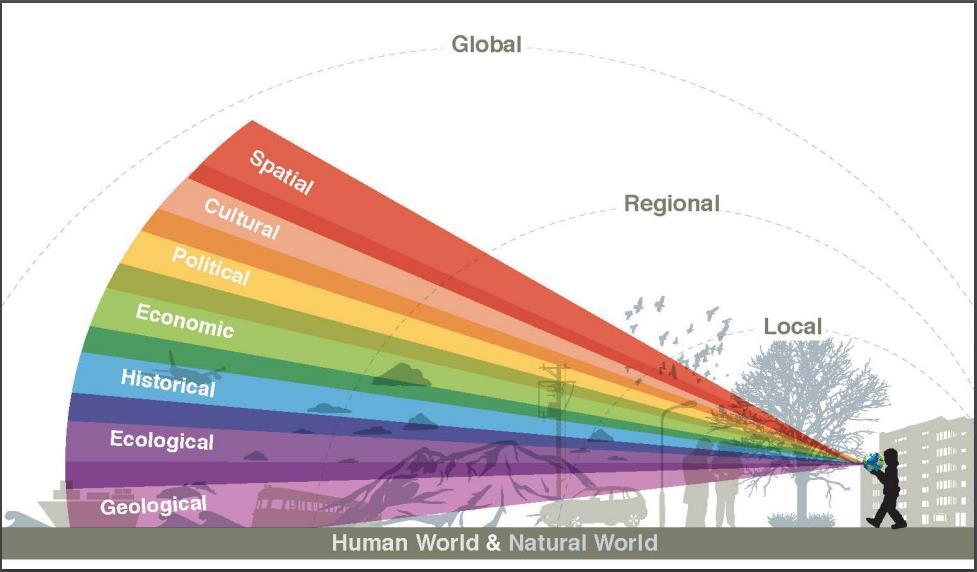
![Unpacking the Geographic Perspective in Social Science Lessons Overarching geographic concepts/frames of understanding (a working model) [PLACE] [SPACE] [SYSTEMS]](/docs-images/88/114602199/images/10-2.jpg "[RESOURCES] These concepts help us probe a topic for geographic insights and formulate questions that help students to discover those insights and practice geographic")
10 Unpacking the Geographic Perspective in Social Science Lessons Overarching geographic concepts/frames of understanding (a working model) [PLACE] [SPACE] [SYSTEMS] [RESOURCES] These concepts help us probe a topic for geographic insights and formulate questions that help students to discover those insights and practice geographic thinking.
 SPACE: A universal of human")
11 Definitions (drawn and elaborated from The Dictionary of Human Geography, 4th Edition) PLACE: A portion of geographic space, named and commonly recognized within a community; bounded settings in which social relations and identity are constituted; space that has gained meaning through history (think of place as subjective, imbued with historical significance) SPACE: A universal of human existence (like time), an external coordinate system of mutually exclusive points (this is absolute space); dimensionality, often understood within particular contexts, and applicable to material, concrete environments and imagined, symbolic environments SYSTEMS: A group of elements organized in such that each one is in some way interdependent with every other element while carrying out an overall function, goal or purpose (not necessarily conscious goals or deliberate intent, function may even be sustainability of the system itself) RESOURCES: A concept used to denote sources of human satisfaction, wealth or strength (e.g., labor, entrepreneurial skills, finances drawn from the human environment as well as mineral and material derived from the physical environment)
![Unpacking the Geographic Perspective in Social Science Lessons Let s take a topic [the presidential election] and work through each of the geographic concepts/frames to identify productive starting](/docs-images/88/114602199/images/12-2.jpg "points for inquiry.")
12 Unpacking the Geographic Perspective in Social Science Lessons Let s take a topic [the presidential election] and work through each of the geographic concepts/frames to identify productive starting points for inquiry. [PLACE] [SPACE] [SYSTEMS] [RESOURCES] Use the sheet of geographic questions to prompt your thinking, but make sure to pose the questions in a way that is relevant to the topic and revealing of important issues related to it.
13 Geographic Questions Exercise Presidential Election Cubs Win PLACE SPACE SYSTEMS RESOURCES
14 Geographic Questions Exercise PLACE SPACE SYSTEMS RESOURCES Presidential Election What does red state/blue state mean? What kinds of states are red/blue? What happens when you are out of place? How do election results project results across space and misrepresent local voting outcomes? Why is there an envelope of restricted space around polling places? What is process for selecting president and how does it ensure relate to representative democracy? What count as resources within a campaign? How are resources understood and framed at different scales? Cubs Win North side/south side Wrigley as hallowed ground How is a unique space created within Wrigley Field? Leagues, farm systems, labor market Which are most important: players, fan bases, knowledge (i.e., Moneyball), capital

15 More Thinking About Geographic Inquiry We ve talked about geographic questions But we are looking to build capacity for geographic reasoning and analysis And answering questions about geographic factors is just a starting point for activating the power of geographic inquiry.
16 The role of geographic questions Questions about simple geographic facts (place and space) Questions about geographic knowledge and perceptions Questions about maps and other geographic representations CONTEXT
17 The role of geographic questions Questions about interactions between geographic facts and the effects of systems on place characteristics and spatial relationships Questions about the use of geographic information and/or geographic representations to effect outcomes Questions about how space is produced, regulated, and differentiated and how that affects possibilities. EXPLANATION
18 The role of geographic questions Questions about how to anticipate and respond to changes in a complex environment Questions about how to practice stewardship of a place Questions about how to exercise locational advantage DECISION MAKING


19 Resources!!! California Geographic Alliance GeoHistogram Esri GeoInquiries National Geographic Education

20 California Geographic Alliance calgeography.org Story Maps under Resources/GeoQuest menu item facebook.com/californiageographicalliance twitter.com/calgeography California Global Education Project:

21 EVER HEARD OF A GEO- HISTO- GRAM?

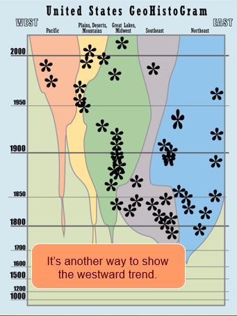
22
23 GeoHistoGrams World GeoHistoGram with related activities: graphy%20resources/pages/world-geohistogram.aspx US GeoHistoGram with related activities: graphy%20resources/pages/u.s.-geohistogram-with-activities.aspx Developed by Michigan Geographic Alliance Standards-based inquiry activities that utilize a web-based map

24 Esri World s leading producer of GIS software, which is free to K-12 schools Standards-based inquiry activities that utilize a web-based map

25

26 ENGAGING WITH THE POLITICS OF EXPANDING U.S. TERRITORY GeoInquiries are instructional activities using ArcGIS software Great way to engage students in both technology and geographic thinking! Free to use, easy to customize Map URL:

27
28 National Geographic Education Activities, Lessons, and Educator Guides Printable Maps and Map Making Projects GeoStories Explorer Classroom Educator Certification Program and Geo-Inquiry PD

 The goal of the National Geography")
 factual knowledge; (2) mental maps and tools; (3) and ways")
29 Essential Element 1: The World in Spatial Terms Each standard is broken down into a few main concepts or competencies Benchmarks are defined for grades 4, 8, and 12 Note that link to National Geography Standards take you to National Geographic Education website with tons of resources NATIONAL STANDARDS (PROTOTYPE) The goal of the National Geography Standards is to enable students to become geographically informed through knowledge and mastery of three things: (1) factual knowledge; (2) mental maps and tools; (3) and ways of thinking.

30 What s the benefit? FIRST ANSWER Teachers and students can have personally meaningful and empowering experiences in and out of the classroom and to have those experiences bring them closer to the world while igniting their own curiosities, insights, and creative impulses.
31


32 Capabilities and Powerful Knowledge
33

34 Geo-Capabilities Amartya Sen (1985): The Capability Approach is defined by its choice of focus upon the moral significance of individuals capability of achieving the kind of lives they have reason to value.

35 Geo-Capabilities Young and Lambert (2014): 3 criteria for defining powerful knowledge: It is distinct from common sense knowledge acquired through everyday experience and therefore context-specific and limited. It is systematic. Its concepts are related to each as part of a discipline with its specific rules and conventions. It can be the basis for generalisations and predictions beyond specific cases or contexts. It is specialized; developed by specialists within defined fields of expertise and enquiry.
36 3 Possible Futures for Education A Future 1 curriculum is the curriculum inherited from the 19 th century which assumes that knowledge is a given and is beyond debate. The future is seen as an extension of the past.

37 3 Possible Futures A Future 2 approach acknowledges that knowledge has social and historical roots. It is defined in terms of particular needs and interests, often those which are dominant in society. It was a response to the rigidity and elitism of the Future 1 model but it was based on a misguided theory of knowledge. The fact that knowledge is socially constructed does not necessarily mean that it is inherently biased or that some knowledge is not better; more valuable, more truthful or more universally applicable.

38 3 Possible Futures Future 3 locates knowledge as the creation of specialist communities of researchers rather than simply treating it as given. It acknowledges that knowledge is fallible, contestable, provisional and subject to change. But in contrast to Future 2 it does not see it as an arbitrary response to a particular challenge; it is bound by epistemic rules about what makes things likely to be true. Future 3 treats subjects as the most reliable tools we have to help students acquire powerful knowledge and make sense of the world. Subjects are a resource to take students beyond their experience, to challenge their existing ideas.
 over time, and not all embrace student-centered approach We do not have space or support for an expansion of geography education, so we need to be")
39 An assessment of our situation Under-preparation of social studies teachers in geography, especially more advanced ways of geographic thinking and reasoning Geography education leadership has narrowed (and aged) over time, and not all embrace student-centered approach We do not have space or support for an expansion of geography education, so we need to be strategic.
")
40 Human(e) Geography How does geography help us understand what has happened, what is happening, and what is likely to happen in my life/our lives/others lives? A geography of flows Representations of space Sociospatial dialectic (how space and society are mutually constitutive)

41 Space of Flows SOME COMPELLING QUESTIONS What kinds of things flow between places? Why? How have flows changed over time? How do you decide when to intervene or manage the way something flows from one place to another?

42 Representations of Space SOME COMPELLING QUESTIONS What are some of the different ways that we encounter representations of space and place? What is the difference between an accurate and an informative representation of the earth? How have representations of the world changed over time?
 identity? Which landscapes shape (American) identity? Do we make places or do places make us?")
43 Sociospatial Dialectic? SOME COMPELLING QUESTIONS How do the environments humans create shape our social patterns and the way we relate to each other? What landscapes reflect (American) identity? Which landscapes shape (American) identity? Do we make places or do places make us? Does cyber space work like physical space in terms of how it relates to society?
 to learn about places. Make maps, take pictures, and tell stories about places.")
44 Conclusions/Recommendations Examine the world closely, beginning at home/school and extending as far as possible. Look at maps, look at pictures, read stories and listen to music (and interpret them) to learn about places. Make maps, take pictures, and tell stories about places. Ask people what places mean to them, how space presents challenges, and how they use geographic strategies. Always challenge your students to think of what could be different, and use geographic inquiry to.
 and create maps. Find ways to get teacher professional development to increase capacity.")
45 Conclusions/Recommendations Connect with the geographic alliance in your home state and seek out online resources from other states alliances. Use geospatial technology to promote spatial and relational thinking (Esri ArcGIS Online, GeoInquiries) and create maps. Find ways to get teacher professional development to increase capacity. Talk to others in your school and district about how geographic inquiry promotes literacy, critical thinking, and STEM skills.
46 Unlocking the Power of Geographic Inquiry Thomas Herman, PhD Director, California Geographic Alliance Department of Geography, San Diego State Univ.
ESSENTIAL CONCEPTS AND SKILL SETS OF THE IOWA CORE CURRICULUM
 ESSENTIAL CONCEPTS AND SKILL SETS OF THE IOWA CORE CURRICULUM SOCIAL STUDIES PROVIDED BY THE IOWA DEPARTMENT OF EDUCATION INTRODUCTION Social studies is the integrated study of the social sciences and
Minnesota Transportation Museum
 Minnesota Transportation Museum Minnesota Social Studies s Alignment Second Grade 1 Code Benchmark 1. Citizenship and Government 1. Civic Skills. Civic Values and Principles of Democracy 4. Governmental
Contents and Pedagogy Standard for Geography Teachers ( 9-12)
") Contents and Pedagogy Standard for Geography Teachers ( 9-12) 1. Background The Geography teachers' professional standards presented in this document have been prepared using the generic standard as an
Contents and Pedagogy Standard for Geography Teachers ( 9-12) 1. Background The Geography teachers' professional standards presented in this document have been prepared using the generic standard as an
Minnesota K-12 Academic Standards in Social Studies. Grade 4: Geography of North America
 Minnesota K-12 Academic s in Social Studies Grade 4: Geography of North America 4 Describe how people take 1. Democratic government action to influence a depends on informed and decision on a specific
Explore! Fossils Original Air Date: January 28, 2015 Grade Levels: 3-6 Archived Program URL: Program Materials Page URL: Program Description:
 Explore! Fossils Original Air Date: January 28, 2015 Grade Levels: 3-6 Archived Program URL: http://www.hectv.org/video/16389/explore-fossils-january-2015/ Program Materials Page URL: http://www.hectv.org/teachers/curriculum/hec-tv-live/explorefossils/
Your web browser (Safari 7) is out of date. For more security, comfort and. the best experience on this site: Update your browser Ignore
 is out of date. For more security, comfort and. the best experience on this site: Update your browser Ignore") Your web browser (Safari 7) is out of date. For more security, comfort and lesson the best experience on this site: Update your browser Ignore Political Borders Why are the borders of countries located
Your web browser (Safari 7) is out of date. For more security, comfort and lesson the best experience on this site: Update your browser Ignore Political Borders Why are the borders of countries located
Master Syllabus Department of Geography GEOG 121: Geography of the Cultural Environment Course Description
 Master Syllabus Department of Geography GEOG 121: Geography of the Cultural Environment Course Description Geography of the Cultural Environment utilizes qualitative methods to investigate relationships
Geography. Programme of study for key stage 3 and attainment target (This is an extract from The National Curriculum 2007)
") Geography Programme of study for key stage 3 and attainment target (This is an extract from The National Curriculum 2007) Crown copyright 2007 Qualifications and Curriculum Authority 2007 Curriculum aims
Geography Programme of study for key stage 3 and attainment target (This is an extract from The National Curriculum 2007) Crown copyright 2007 Qualifications and Curriculum Authority 2007 Curriculum aims
Grade 6 Social Studies
 Grade 6 Social Studies Social Studies Grade(s) 6th Course Overview This course focuses on the five Wisconsin Model Academic standards for Social Studies: Geography, History, Political Science and Citizenship,
Curriculum and Assessment in Geography at KS3
 Curriculum and Assessment in Geography at KS3 Curriculum Statement: Geography The world as we know it is not given and it can and it will change. - Lambert et al. Powerful Knowledge in Geography Geography
ENGAGE. Daily Routines Common Core. Essential Question
 LESSON 7. Time to the Hour and Half Hour FOCUS COHERENCE RIGOR LESSON AT A GLANCE F C R Focus: Common Core State Standards Learning Objective.MD.C.7 Tell and write time from analog and digital clocks to
THE PO L ITICS O F PL ACE-
 Your web browser (Safari 7) is out of date. For more security, comfort and the best experience on this site: Update your browser Ignore Activity Student Version THE PO L ITICS O F PL ACE- NAMING Why are
Canadian Explorers. Learning object La Vérendyre map
 Canadian Explorers Learning object La Vérendyre map Lesson overview Students will be inspired by La Vérendyre to become explorers themselves. Students will embark on a research expedition to discover the
Expanding Canada s Rail Network to Meet the Challenges of the Future
 Expanding Canada s Rail Network to Meet the Challenges of the Future Lesson Overview Rail may become a more popular mode of transportation in the future due to increased population, higher energy costs,
Esri and GIS Education
 Esri and GIS Education Organizations Esri Users 1,200 National Government Agencies 11,500 States & Regional Agencies 30,800 Cities & Local Governments 32,000 Businesses 8,500 Utilities 12,600 NGOs 11,000
Mapping Data 1: Constructing a Choropleth Map
 Mapping Data 1: Constructing a Choropleth Map OVERVIEW & OBJECTIVES Students will become acquainted with mapping data and understanding the importance of recognizing patterns by constructing a choropleth
K- 5 Academic Standards in. Social Studies. June 2013
 K- 5 Academic s in Social Studies June 2013 Word Tables of s ONLY This Word version of the 2.17.12 social studies standards (DRAFT for Rulemaking 2.17.12) document contains the standards ONLY; no explanatory
Course Outline. School Name: Keewaytinook Internet High School. Department Name: Canadian and World Studies. Ministry of Education Course Title:
 School Name: Keewaytinook Internet High School Department Name: Canadian and World Studies Course Outline Ministry of Education Course Title: Travel and Tourism: A Geographic Perspective Grade Level: 11
The maps in this resource can be freely modified and reproduced in the classroom only.
 Teacher's Notes In this activity, students work collaboratively to explore sections of old and new maps. By closely examining these documents, students learn to see maps as more than just tools for locating
TASC Transition Curriculum Project
 TASC Transition Curriculum Project MODULE 3: WORKSHOP 9 REVIEWING THE CROSS-CUTTING CONCEPTS INVOLVED IN SOLVING PROBLEMS PLACED ON STUDENTS IN TASC ABOUT DISCIPLINARY CORE IDEAS POSED IN THE PHYSICAL
Climate Change: How it impacts Canadians and what we can do to slow it down.
 Climate Change: How it impacts Canadians and what we can do to slow it down. Lesson Overview This lesson takes stock of how climate change has already affected Canadians in geographic, economic, and cultural
Your web browser (Safari 7) is out of date. For more security, comfort and. the best experience on this site: Update your browser Ignore
 is out of date. For more security, comfort and. the best experience on this site: Update your browser Ignore") Your web browser (Safari 7) is out of date. For more security, comfort and Activityengage the best experience on this site: Update your browser Ignore Introduction to GIS What is a geographic information
Your web browser (Safari 7) is out of date. For more security, comfort and Activityengage the best experience on this site: Update your browser Ignore Introduction to GIS What is a geographic information
Career and College Readiness in Terms of Next Generation Science Standards (NGSS)
") Career and College Readiness in Terms of Next Generation Science Standards (NGSS) Michigan An NGSS Lead State Partner Next Generation Science Standards for Today s Students and Tomorrow s Workforce Building
Career and College Readiness in Terms of Next Generation Science Standards (NGSS) Michigan An NGSS Lead State Partner Next Generation Science Standards for Today s Students and Tomorrow s Workforce Building
Critical Thinking. about. GeoGRAPHY. United States, Canada, and Greenland. Jayne Freeman
 Critical Thinking about GeoGRAPHY United States, Canada, and Greenland Jayne Freeman WALCH EDUCATION Contents Introduction............................................................... v National Geography
The Purpose of the Charter on Geographical Education
 2016 International Charter on Geographical Education Contents Purpose of the Charter on Geographical Education... 1 The Contribution of Geography to Education 3 Research in Geographical Education... 3
Inquiry Based Instruction Unit. Virginia Kromhout
 Inquiry Based Instruction Unit Virginia Kromhout Unit Title: _Exploring the moon Grade level: _2 grade nd Subject Area: _Science Topic: The Universe Key Words: Moon, lunar surface Designed By: Virginia
Your web browser (Safari 7) is out of date. For more security, comfort and the best experience on this site: Update your browser Ignore
 is out of date. For more security, comfort and the best experience on this site: Update your browser Ignore") Your web browser (Safari 7) is out of date. For more security, comfort and the best experience on this site: Update your browser Ignore U NLO CKING THE EDUCATIO NAL PO TENTIAL O F CITIZEN SCIENCE Essays
Your web browser (Safari 7) is out of date. For more security, comfort and the best experience on this site: Update your browser Ignore U NLO CKING THE EDUCATIO NAL PO TENTIAL O F CITIZEN SCIENCE Essays
Using Geography to Plan Civil War Campsites
 Jake Gordon Civil War Campsite Mapping Lesson Plan pg1 Using Geography to Plan Civil War Campsites Overview: This lesson is designed for an 8 th grade social studies class during the Civil War unit. Students
Risky world. What is risk? Is our local area a risky place? To understand what is meant by risky places
 Lesson 1: Is our local area a risky place? Place - geographical imaginations, physical and human characteristics of real places. Space spatial patterns and distributionsd Scale making links between scales
HISTORY 1XX/ DH 1XX. Introduction to Geospatial Humanities. Instructor: Zephyr Frank, Associate Professor, History Department Office: Building
 HISTORY 1XX/ DH 1XX Introduction to Geospatial Humanities Instructor: Zephyr Frank, Associate Professor, History Department Office: Building 200-332 Course Description This course introduces undergraduate
Dublin City Schools Social Studies Graded Course of Study Grade 5 K-12 Social Studies Vision
 K-12 Social Studies Vision The Dublin City Schools K-12 Social Studies Education will provide many learning opportunities that will help students to: develop thinking as educated citizens who seek to understand
Kindergarten: Foundations of Social Studies
 4. Governmental Institutions and Political Processes 1. Citizenship and Government 2. Civic Values and Principles of Democracy 1.Civic Skills indergarten: Foundations of Social Studies In kindergarten,
Kansas Geographic Alliance Strategic Plan 2013
 Table of Contents Mission..1 Vision for the KGA..1 Vision for Geography...1 Those Behind the KGA.1 Values of the KGA...2 Goals of the KGA..2 KGA History...3 Current Situation of the KGA..3 Organizational
K- 5 Academic Standards in. Social Studies. June 2013
 - 5 Academic s in Social Studies June 2013 Word Tables of s ONLY This Word version of the 2.17.12 social studies standards (DRAFT for Rulemaking 2.17.12) document contains the standards ONLY; no explanatory
The complete lesson plan for this topic is included below.
 Home Connection Parent Information: Magnets provide a simple way to explore force with children. The power of a magnet is somewhat like magic to them and requires exploration to understand. When forces
A Correlation of. Eastern Hemisphere. Ohio s Learning Standards Social Studies: K-12 Grade 6
 A Correlation of Eastern Hemisphere To Grade 6 to,, Grade 6 Introduction This document demonstrates how, Eastern Hemisphere, Ohio Edition, meets : K-12 Social Studies for Grade 6. Correlation page references
MIDDLE TENNESSEE STATE UNIVERSITY Global Studies / Cultural Geography Major Matrix Page 1 of 7
 Page 1 of 7 I. Social Studies Core GS 4990 (3) Senior Seminar in Global Studies SSC 1. Demonstrate critical thinking in the social sciences by GEOG 2000 (1/3) Introduction to Regional Geography posing
SOUTH DAKOTA BOARD OF REGENTS. Academic and Student Affairs ******************************************************************************
 SOUTH DAKOTA BOARD OF REGENTS Academic and Student Affairs AGENDA ITEM: 7 C (4) DATE: June 28-30, 2016 ****************************************************************************** SUBJECT: New Minor:
Houghton Mifflin Harcourt People We Know Minnesota Academic Standards in Social Studies, Grade 2
 Houghton Mifflin Harcourt People We Know 2012 correlated to the Minnesota Academic in Social Studies, Grade 2 Grade 2 2.1 Citizenship and Government 2.1.1 Civic Skills 2.1.1.1 Democratic government depends
Motivating Questions: How many hurricanes happen in a year? Have the number of hurricanes per year changed over time?
 Hurricanes Over Time Materials For the leader: Projector Whiteboard to project data graph onto For the activity: Graphing paper Markers Globe Copy of data cards Overview Hurricanes occur in the North Atlantic
BACK TO SCHO O L W ITH
 Your web browser (Safari 7) is out of date. For more security, comfort and the best experience on this site: Update your browser Ignore BACK TO SCHO O L W ITH GEO - L ITERACY Essays on Geo-Literacy For
Your web browser (Safari 7) is out of date. For more security, comfort and. the best experience on this site: Update your browser Ignore
 is out of date. For more security, comfort and. the best experience on this site: Update your browser Ignore") Your web browser (Safari 7) is out of date. For more security, comfort and Activitydevelop the best experience on this site: Update your browser Ignore Places in the Park Why do we use symbols? Overview
Your web browser (Safari 7) is out of date. For more security, comfort and Activitydevelop the best experience on this site: Update your browser Ignore Places in the Park Why do we use symbols? Overview
Nature s Art Village
 Nature s Art Village Educational Field Trip Programs Guide To: College, Career & Civic Life C3 Framework For Social Studies State Standards Grades 3 through 5 All That Glitters Children journey back in
HOLY CROSS CATHOLIC PRIMARY SCHOOL
 HOLY CROSS CATHOLIC PRIMARY SCHOOL Geography Policy Date Implemented Jan 17 Review Date Jan 22 Mission Statement Holy Cross Primary School is a Catholic School. We seek to provide a broad, balanced Christian
Kindergarten 2011 Social Studies Strands & Standards STRAND SUBSTRAND STANDARD
 2011 Social Studies Strands & Standards STRAND SUBSTRAND STANDARD 0.1 Citizenship & Government 0.2 Economics 0.3 Geography 0.1.1 Civic Skills 0.1.2 Civic Values & Principles of Democracy 0.1.4 Governmental
A Correlation of. Ohio s Learning Standards in Social Studies. Grade 5
 A Correlation of 2019 To in Social Studies Grade 5 Introduction The all new myworld Interactive Social Studies encourages students to explore their world, expand their thinking, and engage their college,
Grade Four Content Overview
 Grade Four Content Overview Physical features Regions Contributions of the states Our Country: Geography and Regions Coastal and inland communities Famous landmarks Physical and human characteristics Local,
GIS Education Activities in Detroit Public Schools Preparing Students for Careers in the Geospatial Industry A Multi-Agency Collaboration
 GIS Education Activities in Detroit Public Schools Preparing Students for Careers in the Geospatial Industry A Multi-Agency Collaboration Marsha A. Lewis, Social Studies Curriculum Specialist, Detroit
HUMANITIES POLICY. Reviewed policy shared with staff on: Autumn Policy to be reviewed again on: Autumn 2018
 HUMANITIES POLICY Reviewed policy shared with staff on: Autumn 2016 Policy to be reviewed again on: Autumn 2018 Committee responsible for review: Learning and Achievement Castilion Primary School HUMANITIES
Your web browser (Safari 7) is out of date. For more security, comfort and. the best experience on this site: Update your browser Ignore
 is out of date. For more security, comfort and. the best experience on this site: Update your browser Ignore") Your web browser (Safari 7) is out of date. For more security, comfort and Activitydevelop the best experience on this site: Update your browser Ignore Introduction to Population Density How can you figure
Your web browser (Safari 7) is out of date. For more security, comfort and Activitydevelop the best experience on this site: Update your browser Ignore Introduction to Population Density How can you figure
correlated to the West Virginia Specific Criteria for Content and Skills Grade Seven: World Geography CC2
 correlated to the West Virginia Specific Criteria for Content and Skills Grade Seven: World Geography CC2 6/2003 2003 Introduction to McDougal Littell World Cultures and Geography: Eastern Hemisphere World
Module 4 Educator s Guide Overview
 Module 4 Educator s Guide Overview Paths Module Overview This module looks at many different kinds of paths and considers why paths are where they are and how they look from space. Paths are usually not
Many Ways to Name a Place
 Your web browser (Safari 7) is out of date. For more security, comfort and Activityapply the best experience on this site: Update your browser Ignore Many Ways to Name a Place What are the names for the
Elem Reading I Methods. Elem Writing Methods. Elem SS Methods. Elem Reading II Methods
 Crosswalk: CO TQ + INTASC + CAEP Standards with TE Courses: July 2015 DRAFT 1 Learning & Dev Foundations 4322/ CO TQ 1a Teachers provide instruction that is aligned with the Colorado Academic Standards
Techniques for Science Teachers: Using GIS in Science Classrooms.
 Techniques for Science Teachers: Using GIS in Science Classrooms. After ESRI, 2008 GIS A Geographic Information System A collection of computer hardware, software, and geographic data used together for
Grade 3 Social Studies
 Grade 3 Social Studies Social Studies Grade(s) 3rd Course Overview This course focuses on the five Wisconsin Model Academic standards for Social Studies: Geography, History, Political Science and Citizenship,
Nevada Integrated Social Studies Standards Grades K-6
 A Correlation of 2008 to the Nevada Integrated Social Studies Standards Grades K-6 M/SS-4A This document demonstrates how and where meets the Nevada Integrated Social Studies Standards. Correlation page
Backward Design Fourth Grade Plant Unit
 Collin Zier Assessment November 2 nd, 2012 Backward Design Fourth Grade Plant Unit Stage One Desired Results Established Goals: Wisconsin s Model Academic Standards for Science 4 th Grade Standard F Life
Forward Thinking: Backward Design. Forward Thinking: Learning Goals Driven Design. What we will do today
 Forward Thinking: Backward Design Joseph Krajcik The University of Michigan National Science Teachers Convention Baltimore, MD November, 2006 Forward Thinking: Learning Goals Driven Design Joseph Krajcik
Fourth Grade Social Studies Crosswalk
 Fourth Grade Social Studies Crosswalk This crosswalk document compares the 2010 K-12 Social Studies Essential Standards and the 2006 North Carolina Social Studies Standard Course of Study (SCOS) and provides
geographic patterns and processes are captured and represented using computer technologies
 Proposed Certificate in Geographic Information Science Department of Geographical and Sustainability Sciences Submitted: November 9, 2016 Geographic information systems (GIS) capture the complex spatial
My Map Activity MINNESOTA SOCIAL STUDIES STANDARDS & BENCHMARKS
 My Map Activity OVERVIEW & OBJECTIVES Students will learn the basics of Google Maps while using geospatial data to create their neighborhood map with the places they spend time. They will also collect
A GIS helps you answer questions and solve problems by looking at your data in a way that is quickly understood and easily shared.
 WHAT IS GIS? A geographic information system (GIS) integrates hardware, software, and data for capturing, managing, analyzing, and displaying all forms of geographically referenced information. GIS allows
Seymour Centre 2017 Education Program 2071 CURRICULUM LINKS
 Suitable for: Stage 5 Stage 6 HSC Subject Links: Seymour Centre 2017 Education Program 2071 CURRICULUM LINKS Science Stage Content Objective Outcomes Stage 5 Earth and Space ES3: People use scientific
ARC Implementation in Residential Care
 ARC Implementation in The First Two Years: Refining the of Care & Building ARC Fidelity Emily Neal, LCSW, Clinical Director Jeremy Karpen, MA, LCPC, Director of Learning & Development 1 Session Objectives
correlated to the West Virginia Specific Criteria for Content and Skills Grade Seven: World Geography CC2
 correlated to the West Virginia Specific Criteria for Content and Skills Grade Seven: World Geography CC2 6/2003 2003 Introduction to McDougal Littell World Cultures and Geography: Western Hemisphere and
Learning Outcomes 2. Key Concepts 2. Misconceptions and Teaching Challenges 3. Vocabulary 4. Lesson and Content Overview 5
 UNIT 1 GUIDE Table of Contents Learning Outcomes 2 Key Concepts 2 Misconceptions and Teaching Challenges 3 Vocabulary 4 Lesson and Content Overview 5 BIG HISTORY PROJECT / UNIT 1 GUIDE 1 Unit 1 What Is
National Geography Standards 1994
 National Geography Standards 1994 Geography Education Standards Project Developed on behalf of the: American Geographical Society Association of American Geographers National Council for Geographic Education
Kindergarten Science, Quarter 4, Unit 5. Plants. Overview
 Kindergarten Science, Quarter 4, Unit 5 Plants Overview Number of instructional days: 20 (1 day = 20 minutes) Content to be learned Distinguish between living and nonliving things. Identify and sort based
How Irrigation Affected the Geography of Northeast Oregon
 Delia Wallis How Irrigation Affected the Geography of Northeast Oregon Grade Levels: 4 (with ability to move up or down) Time: two x 45-minute sessions Overview: Students are going to study topographical
Common Core State Standards for Mathematics
 A Correlation of Pearson to the for Mathematics Introduction This document demonstrates how Pearson s digits program meets the Common Core State Standards for Mathematics. Correlation references are to
GRADE 6 SOCIAL STUDIES SOCIAL STUDIES APPLICATION. SOCIAL STUDIES STANDARDS for Grade 6
 GRADE 6 SOCIAL STUDIES The Archdiocese of Cincinnati has established the following Social Studies standards based on the most current teachings which are aligned to Ohio New Learning Social Studies Standards.
Houghton Mifflin Harcourt Our World, Now and Long Ago Minnesota Academic Standards in Social Studies, Kindergarten
 Houghton Mifflin Harcourt Our World, Now and Long Ago 2012 correlated to the Minnesota Academic in Social Studies, Kindergarten Kindergarten 0.1 Citizenship and Government 0.1.1 Civic Skills 0.1.1.1 Democratic
Time to the Half Hour
 LESSON.7 Time to the Half Hour FOCUS COHERENCE RIGOR LESSON AT A GLANCE F C R Focus: Common Core State Standards.MD.B. Tell and write time in hours and half-hours using analog and digital clocks. MATHEMATICAL
GIS and Business Location Analytics
 UNT s course evaluation system (SPOT - Student Perceptions of Teaching) opened on Monday, April 16 and runs through Thursday, May 3. You should have received an email on April 16 providing guidance on
K- 5 Academic Standards in. Social Studies. June 2013
 K- 5 Academic s in Social Studies June 203 Word Tables of s ONLY This Word version of the 2.7.2 social studies standards (DRAFT for Rulemaking 2.7.2) document contains the standards ONLY; no explanatory
Year 8 standard elaborations Australian Curriculum: Geography
 Purpose Structure The standard elaborations (SEs) provide additional clarity when using the Australian Curriculum achievement standard to make judgments on a five-point scale. These can be used as a tool
Living in a Watershed
 Living in a Watershed Department of Ecosystem Science and Ma... http://ecosystems.psu.edu/youth/sftrc/lesson-plans/water/k-5/watershed Department of Ecosystem Science and Management Youth Living in a Watershed
Discovering Math Concepts in Advanced Algebra Teacher s Guide
 Discovering Math Concepts in Advanced Algebra Teacher s Guide Grade Level: 10 12 Curriculum Focus: Mathematics Lesson Duration: Three class periods Program Description Concepts in Advanced Algebra Calculate
Hestenes lectures, Part 5. Summer 1997 at ASU to 50 teachers in their 3 rd Modeling Workshop
 Hestenes lectures, Part 5. Summer 1997 at ASU to 50 teachers in their 3 rd Modeling Workshop WHAT DO WE TEACH? The question What do we teach? has to do with What do we want to learn? A common instructional
Chapter 1: Introduction to Safety and Ethics
 Core Curriculum Standards Met by Each Chapter On the Right Trail meets Utah s Social Studies Core Curriculum Standards for grades 3-7. Each chapter has specific standard objectives, which are met by the
St Joseph s R.C. Primary School. Policy for Geography
 St Joseph s R.C. Primary School Policy for Geography 2016-2017 This policy is written with consideration to our school commitment to the Rights of the Child and our achievement of becoming a Rights Respecting
MEADOWS PRIMARY SCHOOL and NURSERY GEOGRAPHY POLICY
 MEADOWS PRIMARY SCHOOL and NURSERY GEOGRAPHY POLICY Purpose of study The teaching of Geography at Meadows is done by following the 2014 National Curriculum. The planning and teaching of the subject aims
Elementary School. Assessment Focus: Strand 2 Developing a Geographic Perspective. Geography Content Standard Location, Movement, and Connection
 Michigan Geographic Alliance(1996) Geography Sample Item Elementary School Assessment Focus: Strand 2 Developing a Geographic Perspective Geography Content Standard Location, Movement, and Connection Industrial
Subject: Geography Scheme of Work: B1 to B6 Mastery tiles. Term: Autumn/Spring/Summer
 Subject: Geography Scheme of Work: B1 to B6 Mastery tiles Term: Autumn/Spring/Summer Topic / Unit(s) Overview / Context Introduction to geography. An introduction to geography including basic map skills
Lesson Plans. Year 9 Science Chapter 5. Chemical Reactions I. Assessment. Content Description (5 weeks)
") Lesson Plans Year 9 Science Chapter 5 Chemical Reactions I Some general points about the following lesson plans: The lesson plans outline only one way of sequencing the learning material in this chapter
Lesson Plans Year 9 Science Chapter 5 Chemical Reactions I Some general points about the following lesson plans: The lesson plans outline only one way of sequencing the learning material in this chapter
Diverse Places 3 days
 AS Level Geography Edexcel Diverse Places 3 days Deliver two days of fieldwork within a dynamic human environment and cover the recommended themes in depth. Fieldwork in these locations provides a contrast
Joanne N. Halls, PhD Dept. of Geography & Geology David Kirk Information Technology Services
 Joanne N. Halls, PhD Dept. of Geography & Geology David Kirk Information Technology Services Geographic Information Systems manage and analyze data to solve spatial problems. Real World Abstraction Analysis
A spatial literacy initiative for undergraduate education at UCSB
 A spatial literacy initiative for undergraduate education at UCSB Mike Goodchild & Don Janelle Department of Geography / spatial@ucsb University of California, Santa Barbara ThinkSpatial Brown bag forum
GRADE 5 SOCIAL STUDIES SOCIAL STUDIES APPLICATION. SOCIAL STUDIES STANDARDS for Grade 5
 GRADE 5 SOCIAL STUDIES The Archdiocese of Cincinnati has established the following Social Studies standards based on the most current teachings which are aligned to Ohio New Learning Social Studies Standards.
Pacing: Block = 45 minutes
 Name Class Date _ Learning Unit: Inquiry (Mathematics); Interactions (Science) Lesson Plan: Counting Sunspots Content Strand: Data Analysis and Probability (Mathematics); Content Strand: Energy Transformation
Grade 4 Benchmarks. Benchmark Concepts Skills Essential Question(s)
") **Be aware of the use of and & or in the benchmark language related to Canada and Mexico; sometimes students may look at the US and one of our neighboring countries and other times students need to study
**Be aware of the use of and & or in the benchmark language related to Canada and Mexico; sometimes students may look at the US and one of our neighboring countries and other times students need to study
Saskatchewan s Early Trade Routes: The Impact of Geography on Trade
 Saskatchewan s Early Trade Routes: The Impact of Geography on Trade Lesson Overview In this lesson, students will compare and contrast prehistoric First Nations trade routes and trade goods with the routes
Bridging Geo technology Competence Gaps among Kenyan Undergraduate Students: An Interdisciplinary GIS Training Model at Chuka University
 International Journal of Education, Culture and Society 2016; 1(3): 70-74 http://www.sciencepublishinggroup.com/j/ijecs doi: 10.11648/j.ijecs.20160103.11 Bridging Geo technology Competence Gaps among Kenyan
Reading a Map in Any Language. Dawn Shattuck NICC; Kathy Sundstedt School not available. Content Area (Req.): Geography Unit (Opt.
: Geography Unit (Opt.") Instructional Sequence/Procedure (Req.): 1. Distribute one copy of Chile map, written in Spanish, to each student group OR direct each group of students to access an online copy of a Chile map. 2. Together,
Instructional Sequence/Procedure (Req.): 1. Distribute one copy of Chile map, written in Spanish, to each student group OR direct each group of students to access an online copy of a Chile map. 2. Together,
School Program Name: Name of Sanctuary: Grade Level: Grades 6 8 Location Options: Time:
 School Program Name: Name of Sanctuary: Grade Level: Grades 6 8 Location Options: Time: For more info: Landforms of New England Moose Hill Wildlife Sanctuary At the sanctuary 2 hours or combine with another
The Kenton County School District A System of Excellence Social Studies 4.1 Core Content for Assessment
 Big Idea: Government and Civics The study of government and civics allows students to understand the nature of government and the unique characteristics of American democracy, including its fundamental
TRAITS to put you on the map
 TRAITS to put you on the map Know what s where See the big picture Connect the dots Get it right Use where to say WOW Look around Spread the word Make it yours Finding your way Location is associated with
Major Languages of the Americas
 Your web browser (Safari 7) is out of date. For more security, comfort and Activitydevelop the best experience on this site: Update your browser Ignore Major Languages of the Americas How are languages
Your web browser (Safari 7) is out of date. For more security, comfort and. the best experience on this site: Update your browser Ignore
 is out of date. For more security, comfort and. the best experience on this site: Update your browser Ignore") Your web browser (Safari 7) is out of date. For more security, comfort and Activitydevelop the best experience on this site: Update your browser Ignore Extracting Gas from Shale How is natural gas extracted
Your web browser (Safari 7) is out of date. For more security, comfort and Activitydevelop the best experience on this site: Update your browser Ignore Extracting Gas from Shale How is natural gas extracted