Modelling the Atmospheric Urban Heat Island and its Contributing Spatial Characteristics
|
|
|
- Dayna Jones
- 6 years ago
- Views:
Transcription

1 the Atmospheric Urban Heat Island and its Contributing Characteristics The Case of The Hague, the Netherlands Anna-Maria Ntarladima Alexander Wandl Hugo Ledoux 02/11/2016
2 Urban Heat Island (UHI) is a phenomenon in which a city forms microclimates which heatup quicker than its rural surroundings. ΔΤ(u-r) = Tu- Tr (Oke,1982;, Johnson & Wilson,2009; Arnfield, 2003; Taha et al.,1997; van der Hoeven & Wandl, 2015; Li et al., 2011; Steeneveld et al., 2011) 2
3 There are different UHI types depending on the layer in which the temperature is measured UBL Surface UHI Atmospheric UHI Upper Atmospheric UHI LST UCL (EPA, 2008) 3
4 The UHI types share different characteristics in terms of temporal development, intensity and spatial distribution LST UBL UCL (EPA, 2008) 4

5 The UHI was assumed to have minor effects in The Netherlands till the first major heat-wave (2003) UBL Unhealthiness Mortality Discomfort Respiratory disorders (Garssen, 2005; Hoeven & Wandl, 2015; Mavrogianni, 2011) 5
6 The aim of this research is to estimate the air temperature for the entire area of interest dynamically, constructing a model The scope of this research is to bridge the gap between the raw data and the qualitative research capabilities of planners and designers enable them design more livable cities 6

7 UBL The Municipality of The Hague The Area of Interest 7


8 UBL Netatmo weather station Netatmo weather map 8

9 Define the spatial unit CBS 100m*100m grid UBL CBS grid, 100*100 combined with a fishnet 9
10 Q* = QE + QH + QS Datasets derived: QE QH Vegetation Index Water Surfaces Imperviousness Albedo Distance from the Coastline QS Building Footprint Height of the buildings Building Volume Sky View Factor 10
11 Organize all data into the grid A certain methodology was applied in ArcGIS Values for each spatial variable were assigned to all grid-cells Example: Footprints, Values: Example: Coastline Proximity, Values: 0 max. distance UBL Footprints 11

12 Organize all data into the grid A certain methodology was applied in ArcGIS Values for each spatial variable were assigned to all grid-cells Example: Footprints, Values: Example: Coastline Proximity, Values: 0 max. distance UBL Coastline Proximity 12


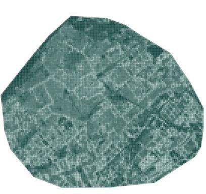
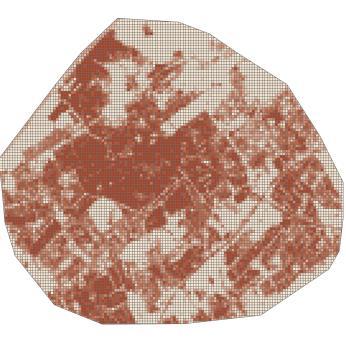
13 LST NDVI Water Surfaces Albedo Coastal Proximity B. Heights Footprints SVF Imperviousness B. Volume 13


14 14

15 The spatial variables have different behavior during day and night Air temperature, has smaller heat capacity temperature changes quicker Day division based on the inflection points UBL Temperature-time graph 15
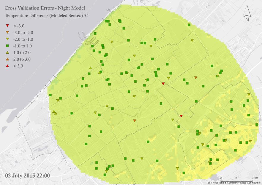
16 Adjusted Std. Error of the R Square Change Change Statistics F Change df1 df2 Model R R Square R Square Estimate Night.639 a a. Predictors: (Constant), SVF, KNMI_344, Coastline Proximity, Albedo, Footprint b. Dependent Variable: aver_s_tem Adjusted Std. Error of the R Square Change Change Statistics F Change df1 df2 Model R R Square R Square Estimate 05_ a a. Predictors: (Constant), Imperviousness Copern, KNMI_344, Albedo, NDVI b. Dependent Variable: aver_s_tem 16

17 17

18 Cooling-down model (22:00 06:00) 18
19 Heating-up model (06:00 13:00) 19


20 Dynamic Time is used as input data Animated maps enable large dataseries visualization More perceivable Easy pattern and trend detection If animated visualization was not utilized in this study, 80 different maps would have been presented instead of concise videos 20
21 21
22 22
23 The day and night models are affected from different indicators Both models follow the builtenvironment pattern The nocturnal model is mostly affected by the Coastline Proximity Thus, there are densely urbanized areas with low temperature by the sea 23


24 Limitations Uncertainty of the sensor data quality Sensor orientation leads to different results Biased sensor sample Ta is highly affected by air movements and circulation Recommendations Sensor installation Use more sensors Acquire information about the sensor orientation Model the air movements (CFD) 24


25 Adaption Use lighter colors (increase albedo) Use less impervious materials Increase Vegetation Street orientation (vertical to the coastline) to maximize the see breeze effect Lower building coefficient close to sea. Sensor installation 25
26 Thank you for the attention
27 Questions
28 Questions 28
29 The extreme outliers were excluded from the datasets The mild outliers were kept since they follow logical time development Test for normality Correlation analysis Multi-collinearity analysis Regression analysis Box-plot 33
30 Surface temperature and atmospheric temperature behave differently Ts has strong and significant relation with most indicators Ts is not related with the Ta Ta, due to the small heat capacity and air movements, is more prone to temporal changes greater day division is needed Correlations Day Night aver_s_tem LST aver_s_tem LST aver_s_tem KNMI_ ** ** KNMI_ ** LST NDVI ** ** Albedo ** **.244 ** Water ** ** Coastline Proximity.154 ** **.166 ** ** Footprint *.460 ** *.452 ** Buildings Height **.171 ** *.177 ** Building Density **.211 ** *.214 ** SVF.063 **.173 ** ** Imperviousness ** ** **. Correlation is significant at the 0.01 level (1-tailed). *. Correlation is significant at the 0.05 level (1-tailed). 34

31 KNMI weather stations are located in the rural area It is a valuable dataset to model UHI Provides hourly temperature updates which enable the dynamic representation UBL KNMI weather stations 35
32 Datasets used: Sensor data Top10NL AHN3 Imperviousness (Copernicus) Satellite images KNMI 330 and 344 temperatures CBS grid Datasets derived: Land Surface Temperature Vegetation Index Water Surfaces Albedo Distance from the Coastline Building Footprint Height of the buildings Building Volume Sky View Factor Imperviousness 36

33 37


34 38
Modelling the Atmospheric Urban Heat Island and its Contributing Spatial Characteristics
 the Atmospheric Urban Heat Island and its Contributing Characteristics The Case of The Hague, the Netherlands Anna-Maria Ntarladima 07/11/2016 Urban Heat Island (UHI) is a phenomenon in which a city forms
Applications of GIS and Remote Sensing for Analysis of Urban Heat Island
 Chuanxin Zhu Professor Peter V. August Professor Yeqiao Wang NRS 509 December 15, 2016 Applications of GIS and Remote Sensing for Analysis of Urban Heat Island Since the last century, the global mean surface
Quantifying the influence of wind advection on the urban heat island for an improvement of a climate change adaptation planning tool
 Quantifying the influence of wind advection on the urban heat island for an improvement of a climate change adaptation planning tool BEAR conference 15/12/2014 Bassett R., Cai X., Chapman L., Heaviside
Lech GAWUC, Joanna STRUZEWSKA. Meteorology Division Faculty of Environmental Engineering Warsaw University of Technology Warsaw, Poland
 Analysis of the impact of different temporal aggregation techniques of land surface temperature on SUHI indicators and the relationship of surface temperature with population density and night lighting
High-resolution simulations of the Urban Heat Island
 24 October 2013 High-resolution simulations of the Urban Heat Island Andrew Monaghan, Michael Barlage, Leiqiu Hu, Nathan Brunsell, Johannes Feddema, Keith Oleson, Olga Wilhelmi and Steve Sain 1 (Oleson
Determining the Optimal Grid Size of Local Climate Zones for Spatial Mapping in High-density Cities
 Determining the Optimal Grid Size of Local Climate Zones for Spatial Mapping in High-density Cities Kevin Ka-Lun Lau, Chao Ren, Yuan Shi, Venessa Zheng,, Hong Kong Background Urbanization results in distinctive
ANALYSIS OF THE INTRA-CITY VARIATION OF URBAN HEAT ISLAND AND ITS RELATION TO LAND SURFACE/COVER PARAMETERS
 ANALYSIS OF THE INTRA-CITY VARIATION OF URBAN HEAT ISLAND AND ITS RELATION TO LAND SURFACE/COVER PARAMETERS D. Gerçek a *, İ.T. Güven a, İ.Ç. Oktay b a Kocaeli University, Faculty of Architecture and Design,
EXPLORING THE URBAN HEAT ISLAND INTENSITY OF DUTCH CITIES
 EXPLORING THE URBAN HEAT ISLAND INTENSITY OF DUTCH CITIES L.W.A. van Hove 1,2, C.M.J. Jacobs 3, B.G. Heusinkveld 1, J.A. Elbers 3, G.J. Steeneveld 1, S. Koopmans 1, E.J. Moors 3, A.A.M. Holtslag 1 1 Wageningen
MODIS-BASED INVESTIGATIONS ON THE URBAN HEAT ISLANDS OF BUCHAREST (ROMANIA) AND PRAGUE (CZECH REPUBLIC)
 AND PRAGUE (CZECH REPUBLIC)") MODIS-BASED INVESTIGATIONS ON THE URBAN HEAT ISLANDS OF BUCHAREST (ROMANIA) AND PRAGUE (CZECH REPUBLIC) Sorin Cheval*, Michal Žák***, Alexandru Dumitrescu*, Vít Květoň** *National Meteorological Administration,
MODIS-BASED INVESTIGATIONS ON THE URBAN HEAT ISLANDS OF BUCHAREST (ROMANIA) AND PRAGUE (CZECH REPUBLIC) Sorin Cheval*, Michal Žák***, Alexandru Dumitrescu*, Vít Květoň** *National Meteorological Administration,
Results of the ESA-DUE UHI project
 13/12/2011 Results of the ESA-DUE UHI project Bino Maiheu (bino.maiheu@vito.be), on behalf of the UHI project Outline» Urban heat island problem» The ESA-DUE urban heat island project» UHI air temperature
ASSESSING THERMAL RISK IN URBAN AREAS AN APPLICATION FOR THE URBAN AGGLOMERATION OF ATHENS
 ASSESSING THERMAL RISK IN URBAN AREAS AN APPLICATION FOR THE URBAN AGGLOMERATION OF ATHENS Polydoros T. and Cartalis C. Department of Environmental Physics, University of Athens, University Campus, Build
Spatial variability of building frontal area index and its relationship with urban heat island intensity
 Spatial variability of building frontal area index and its relationship with urban heat island intensity Man Sing WONG, Janet NICHOL Department of Land Surveying and Geo-Informatic, The Hong Kong Polytechnic
SENSITIVITY STUDY FOR SZEGED, HUNGARY USING THE SURFEX/TEB SCHEME COUPLED TO ALARO
 SENSITIVITY STUDY FOR SZEGED, HUNGARY USING THE SURFEX/TEB SCHEME COUPLED TO ALARO Report from the Flat-Rate Stay at the Royal Meteorological Institute, Brussels, Belgium 11.03.2015 01.04.2015 Gabriella
Building Energy Demand under Urban Climate and Climate Change conditions with consideration of Urban Morphology and Building Typology
 Building Energy Demand under Urban Climate and Climate Change conditions with consideration of Urban Morphology and Building Typology - GIS Mapping of the City of Stuttgart Limei Ji Fazia Ali-Toudert 1,
Abstract: Introduction: 10 th ESRI India User Conference 2009 Geography in Action
 Mitigation of Thermal Pollution to enhance urban air quality through Remote Sensing and GIS Anshu Gupta, Lecturer, Centre of Remote Sensing and GIS, MANIT, Bhopal, E- mail: anshugupta20002001@gmail.com
Temporal and spatial distributions of urban heat island in Nanjing. Yu Zhou
 Temporal and spatial distributions of urban heat island in Nanjing Yu Zhou 2015.4.17 Outline Background Objectives Method and Data Quality Results and Discussion On-going work Background: UHI The accelerated
Research Article A Quantitative Assessment of Surface Urban Heat Islands Using Satellite Multitemporal Data over Abeokuta, Nigeria
 International Atmospheric Sciences Volume 2016, Article ID 3170789, 6 pages http://dx.doi.org/10.1155/2016/3170789 Research Article A Quantitative Assessment of Surface Urban Heat Islands Using Satellite
Validation Results of a Spatially Fine-Scale Air Temperature Statistical Model in New York City
 Validation Results of a Spatially Fine-Scale Air Temperature Statistical Model in New York City Brian Vant-Hull, Maryam Karimi, Awalou Sossa, Louis Waxman, Estatio Guiterrez, Sarah Johnson*, Rouzbeh Nazari
Case study of an urban heat island in London, UK: Comparison between observations and a high resolution numerical weather prediction model
 Case study of an urban heat island in London, UK: Comparison between observations and a high resolution numerical weather prediction model Siân Lane, Janet Barlow, Humphrey Lean With thanks to Christos
Comparing the diurnal and seasonal variabilities of atmospheric and surface urban heat islands based on the Beijing urban meteorological network
 Comparing the diurnal and seasonal variabilities of atmospheric and surface urban heat islands based on the Beijing urban meteorological network Kaicun Wang, Shaojing Jiang, Jiankai Wang, Chunlüe Zhou,
Critical review of the Climate Change Impact on urban areas by assessment of Heat Island effect
 Critical review of the Climate Change Impact on urban areas by assessment of Heat Island effect Case of Pune, India Town Planning, Civil Department Prof. Omkar Parishwad, ogp.civil@coep.ac.in Climate Change
Urban heat island effects over Torino
 3 Working Group on Physical Aspects: Soil and Surface 3 Urban heat island effects over Torino M. Milelli 1 1 ARPA Piemonte 1 Introduction Figure 1: Urban heat island generalized scheme (source: EPA). The
AssessmentofUrbanHeatIslandUHIusingRemoteSensingandGIS
 Global Journal of HUMANSOCIAL SCIENCE: B Geography, GeoSciences, Environmental Science & Disaster Management Volume 16 Issue 2 Version 1.0 Type: Double Blind Peer Reviewed International Research Journal
Ethiopian Journal of Environmental Studies and Management Vol. 6 No
 EVALUATION OF URBANIZATION INFLUENCES ON URBAN WINDS OF KENYAN CITIES *ONGOMA, V., 1 MUTHAMA, N. J., 2 and GITAU, W. 2 http://dx.doi.org/10.4314/ejesm.v6i3.1 Received 27th July 2012; accepted 12th March
Lancaster Environment Centre, Lancaster University, Lancaster, LA1 4YQ, UK;
 Title Page Dynamics and controls of urban heat sink and island phenomena in a desert city: development of a local climate zone scheme using remotely-sensed inputs Ahmed K. NASSAR (corresponding author)
SPECIAL PROJECT PROGRESS REPORT
 SPECIAL PROJECT PROGRESS REPORT Progress Reports should be 2 to 10 pages in length, depending on importance of the project. All the following mandatory information needs to be provided. Reporting year
Mario Flores, Graduate Student Department of Applied Mathematics, UTSA. EES 5053: Remote Sensing
 Mario Flores, Graduate Student Department of Applied Mathematics, UTSA Miguel Balderas, E.I.T., Graduate Student Department of Civil/Environmental Engineering, UTSA EES 5053: Remote Sensing REMOTE SENSING
EFFECTS OF TOPOGRAPHY ON URBAN HEAT ISLAND. University of Zagreb, Croatia
 EFFECTS OF TOPOGRAPHY ON URBAN HEAT ISLAND Theodoros Nitis 1,2, Zvjezdana B. laić 3 and Nicolas Moussiopoulos 1 1 Laboratory of Heat Transfer and Environmental Engineering, Aristotle University, Greece
CORRELATION BETWEEN URBAN HEAT ISLAND EFFECT AND THE THERMAL INERTIA USING ASTER DATA IN BEIJING, CHINA
 CORRELATION BETWEEN URBAN HEAT ISLAND EFFECT AND THE THERMAL INERTIA USING ASTER DATA IN BEIJING, CHINA Yurong CHEN a, *, Mingyi DU a, Rentao DONG b a School of Geomatics and Urban Information, Beijing
Remote Sensing of Urban Surface Temperatures
 Remote Sensing of Urban Surface Temperatures James Voogt University of Western Ontario London, Ontario, Canada This work is supported by the Natural Sciences and Engineering Research Council of Canada.
NOTES AND CORRESPONDENCE. Evaluation of Temperature Differences for Paired Stations of the U.S. Climate Reference Network
 15 MAY 2005 N O T E S A N D C O R R E S P O N D E N C E 1629 NOTES AND CORRESPONDENCE Evaluation of Temperature Differences for Paired Stations of the U.S. Climate Reference Network KEVIN P. GALLO* NOAA/NESDIS,
MODELING URBAN THERMAL ANISOTROPY
 MODELING URBAN THERMAL ANISOTROPY J. A. Voogt a, *, E. S. Krayenhoff a a Department of Geography, University of Western Ontario, London ON N6A 5C2 Canada -javoogt@uwo.ca KEY WORDS: surface temperature,
A "Local Climate Zone" based approach to urban planning in Colombo, Sri Lanka
 A "Local Climate Zone" based approach to urban planning in Colombo, Sri Lanka N G R Perera 1 *, M P R Emmanuel 2 Department Of Architecture, University Of Moratuwa, Sri Lanka 1* nareinperera@gmail.com
Earth Science Lesson Plan Quarter 2, Week 6, Day 1
 Earth Science Lesson Plan Quarter 2, Week 6, Day 1 1 Outcomes for Today Standard Focus: Earth Sciences 5.f students know the interaction of wind patterns, ocean currents, and mountain ranges results in
Investigating the urban climate characteristics of two Hungarian cities with SURFEX/TEB land surface model
 Investigating the urban climate characteristics of two Hungarian cities with SURFEX/TEB land surface model Gabriella Zsebeházi Gabriella Zsebeházi and Gabriella Szépszó Hungarian Meteorological Service,
The Road to Data in Baltimore
 Creating a parcel level database from high resolution imagery By Austin Troy and Weiqi Zhou University of Vermont, Rubenstein School of Natural Resources State and local planning agencies are increasingly
The footprint of urban heat island effect in China
 A discussion on the paper The footprint of urban heat island effect in China By Decheng Zhou, Shuqing Zhao, Liangxia Zhang, Ge Sun & Yongqiang Liu Published in SCIENCE REPORRTS Reporter: Mu Qingchen 2015.10.23
Local Climate Zones. Origins, development, and application to urban heat islands. Iain Stewart and Tim Oke
 Local Climate Zones Origins, development, and application to urban heat islands Iain Stewart and Tim Oke Department Geography University of British Columbia Vancouver CANADA Annual Meeting of the American
A Multi-City Analysis of the Natural and Human Drivers of the Urban Heat Island
 A Multi-City Analysis of the Natural and Human Drivers of the Urban Heat Island A THESIS SUBMITTED TO THE FACULTY OF THE GRADUATE SCHOOL OF THE UNIVERSITY OF MINNESOTA BY William Frederick Hertel IN PARTIAL
GIS.
 GIS 389 Vol., No.3, Autumn 00 89-0 GIS Iranian Remote Sensing & GIS ( : ) ETM+ *.. 390/3/7 : 389/5/3 : (LST).. 00 3 ETM+.. MNF NDVI. SEBAL. FVC NDVI... (FVC) SEBAL (LULC) (LST) :. 887708 : : * Email: taleai@kntu.ac.ir
MONITORING THE SURFACE HEAT ISLAND (SHI) EFFECTS OF INDUSTRIAL ENTERPRISES
 EFFECTS OF INDUSTRIAL ENTERPRISES") MONITORING THE SURFACE HEAT ISLAND (SHI) EFFECTS OF INDUSTRIAL ENTERPRISES A. Şekertekin a, *, Ş. H. Kutoglu a, S. Kaya b, A. M. Marangoz a a BEU, Engineering Faculty, Geomatics Engineering Department
MONITORING THE SURFACE HEAT ISLAND (SHI) EFFECTS OF INDUSTRIAL ENTERPRISES A. Şekertekin a, *, Ş. H. Kutoglu a, S. Kaya b, A. M. Marangoz a a BEU, Engineering Faculty, Geomatics Engineering Department
Jay Lawrimore NOAA National Climatic Data Center 9 October 2013
 Jay Lawrimore NOAA National Climatic Data Center 9 October 2013 Daily data GHCN-Daily as the GSN Archive Monthly data GHCN-Monthly and CLIMAT messages International Surface Temperature Initiative Global
Outdoor Thermal Comfort and Local Climate Change: Exploring Connections
 Outdoor Thermal Comfort and Local Climate Change: Exploring Connections ROBERTA COCCI GRIFONI 1, MARIANO PIERANTOZZI 2, SIMONE TASCINI 1 1 School of Architecture and Design E. Vittoria, University of Camerino,
Applying "Local Climate Zone (LCZ)" into a High-density High-rise Cities - A Pilot Study in Hong Kong
 into a High-density High-rise Cities - A Pilot Study in Hong Kong") Applying "Local Climate Zone (LCZ)" into a High-density High-rise Cities - A Pilot Study in Hong Kong Chao REN Yingsheng ZHENG 1, Chao REN 1,2 *, Yuan SHI 1, Kevin Ka-Lun LAU 1, Steve Hung Lam YIM 3,4,Derrick
Applying "Local Climate Zone (LCZ)" into a High-density High-rise Cities - A Pilot Study in Hong Kong Chao REN Yingsheng ZHENG 1, Chao REN 1,2 *, Yuan SHI 1, Kevin Ka-Lun LAU 1, Steve Hung Lam YIM 3,4,Derrick
Evaluation of building-scale heat-stress analysis system (BioCAS) based on mortality observation in Seoul
 based on mortality observation in Seoul") ICUC9 9th International Congress on Urban Climate 20 24 July, 2015, Toulouse France Evaluation of building-scale heat-stress analysis system (BioCAS) based on mortality observation in Seoul National Institute
ICUC9 9th International Congress on Urban Climate 20 24 July, 2015, Toulouse France Evaluation of building-scale heat-stress analysis system (BioCAS) based on mortality observation in Seoul National Institute
Remote sensing Based Assessment of Urban Heat Island Phenomenon in Nagpur Metropolitan Area
 International Journal of Information & Computation Technology. ISSN 0974-2239 Volume 4, Number 11 (2014), pp. 1069-1074 International Research Publications House http://www. irphouse.com Remote sensing
How Researchers Measure Urban Heat Islands. James Voogt Department of Geography, University of Western Ontario London ON Canada
 How Researchers Measure Urban Heat Islands James Voogt Department of Geography, University of Western Ontario London ON Canada Outline What is the urban heat island? What types of urban heat islands exist?
Spatio-Temporal Trends of Urban Heat Island and Surface Temperature in Izmir, Turkey
 American Journal of Remote Sensing 2017; 5(3): 24-29 http://www.sciencepublishinggroup.com/j/ajrs doi: 0.11648/j.ajrs.20170503.11 ISSN: 2328-5788 (Print); ISSN: 2328-580X (Online) Spatio-Temporal Trends
Seasonal Variations of the Urban Heat Island Effect:
 Seasonal Variations of the Urban Heat Island Effect: Examining the Differences in Temperature Between the City of Philadelphia and its Outlying Suburbs By: Frank Vecchio 1 P a g e We re calling for a high
GIS Analysis for the Climatic Evaluation of 3D Urban Geometry The Development of GIS Analytical Tools for Sky View Factor
 GIS Analysis for the Climatic Evaluation of 3D Urban Geometry The Development of GIS Analytical Tools for Sky View Factor Wenjing LI, Simon Yanuar PUTRA, Perry Pei-Ju YANG * Department of Architecture
Urban heat island in the metropolitan area of São Paulo and the influence of warm and dry air masses during summer
 Urban heat island in the metropolitan area of São Paulo and the influence of warm and dry air masses during summer Flavia N. D. Ribeiro1, Arissa S. umezaki1, Jhonathan F. T. de Souza1, Jacyra Soares2,
Future Cities and Environment
 Bourikas et al. Future Cities and Environment (2016) 2:7 DOI 10.1186/s40984-016-0020-4 Future Cities and Environment TECHNICAL ARTICLE Transforming typical hourly simulation weather data files to represent
Subtropical Urban Heat Island Development and Estimation Around Taipei City, Taiwan
 1 Subtropical Urban Heat Island Development and Estimation Around Taipei City, Taiwan WEN-ZER LIN a,*, HSIAO-CHUNG TSAI b, CHUNG-HO WANG c, CHIA CHOU a a Research Center for Environmental Changes, Academia
Evaluation of land surface temperature (LST) patterns in the urban agglomeration of Krakow using different satellite data and GIS
 patterns in the urban agglomeration of Krakow using different satellite data and GIS") Evaluation of land surface temperature (LST) patterns in the urban agglomeration of Krakow using different satellite data and GIS Jakub P. Walawender 1,2 1 Satellite Remote Sensing Centre, Institute of
Evaluation of land surface temperature (LST) patterns in the urban agglomeration of Krakow using different satellite data and GIS Jakub P. Walawender 1,2 1 Satellite Remote Sensing Centre, Institute of
An Analysis of Urban Cooling Island (UCI) Effects by Water Spaces Applying UCI Indices
 Effects by Water Spaces Applying UCI Indices") An Analysis of Urban Cooling Island (UCI) Effects by Water Spaces Applying UCI Indices D. Lee, K. Oh, and J. Seo Abstract An urban cooling island (UCI) involves an area that has a lower temperature compared
An Analysis of Urban Cooling Island (UCI) Effects by Water Spaces Applying UCI Indices D. Lee, K. Oh, and J. Seo Abstract An urban cooling island (UCI) involves an area that has a lower temperature compared
THE USE OF REMOTE SENSING AND GEOSPATIAL TECHNIQUES FOR URBAN CLIMATE ANALYSIS: A CASE STUDY OF ABU DHABI CITY AREA
 THE USE OF REMOTE SENSING AND GEOSPATIAL TECHNIQUES FOR URBAN CLIMATE ANALYSIS: A CASE STUDY OF ABU DHABI CITY AREA Michele Lazzarini, Jacinto Estima, Prashanth Reddy Marpu, Hosni Ghedira Earth Observation
Modeling Study of Atmospheric Boundary Layer Characteristics in Industrial City by the Example of Chelyabinsk
 Modeling Study of Atmospheric Boundary Layer Characteristics in Industrial City by the Example of Chelyabinsk 1. Introduction Lenskaya Olga Yu.*, Sanjar M. Abdullaev* *South Ural State University Urbanization
Using sensor data and inversion techniques to systematically reduce dispersion model error
 Using sensor data and inversion techniques to systematically reduce dispersion model error D. J. Carruthers 1, A. L. Stidworthy 1, D. Clarke 2, K.J. Dicks 3, R. L. Jones 4,I. Leslie 5, O. A. M. Popoola
Areas of the World with high Insolation
 Areas of the World with high Insolation 22 /43 Africa Annual Average Global Horizontal Solar Radiation Map 19 Jul 2006 A map depicting model estimates of monthly average daily total radiation using inputs
The AWS based operational urban network in Milano: achievements and open questions.
 The AWS based operational urban network in Milano: achievements and open questions. Frustaci Giuseppe, Curci Savino, Pilati Samantha, Lavecchia Cristina, Paganelli Chiara Fondazione Osservatorio Meteorologico
ANNUAL SPATIO-TEMPORAL VARIABILITY OF TOULOUSE URBAN HEAT ISLAND. Grégoire Pigeon* and Valéry Masson CNRM-GAME, Météo France-CNRS, Toulouse, France
 J12.4A ANNUAL SPATIO-TEMPORAL VARIABILITY OF TOULOUSE URBAN HEAT ISLAND Grégoire Pigeon* and Valéry Masson CNRM-GAME, Météo France-CNRS, Toulouse, France 1 INTRODUCTION The urban heat island (UHI) has
Analysis on Factors of Summer Temperature Distribution in the Basin City
 Analysis on Factors of Summer Temperature Distribution in the Basin City SHOHEI NOGUCHI 1, TAKAHIRO TANAKA 2, SATORU SADOHARA 3 1 Graduate School of Engineering, Hiroshima University, Higashihiroshima,
Chapter 3: Temperature
 Chapter 3: Temperature Elements of WAC (Basic Measurable Properties) 1. Temperature of Air 2. Humidity of Air 3. Cloud Cover (type and amount) 4. Precipitation (type and amount) 5. Air Pressure 6. Wind
Comparison between Land Surface Temperature Retrieval Using Classification Based Emissivity and NDVI Based Emissivity
 Comparison between Land Surface Temperature Retrieval Using Classification Based Emissivity and NDVI Based Emissivity Isabel C. Perez Hoyos NOAA Crest, City College of New York, CUNY, 160 Convent Avenue,
Challenges and benefits from crowdsourced atmospheric data for urban climate research using Berlin, Germany, as testbed
 1. Introduction Challenges and benefits from crowdsourced atmospheric data for urban climate research using Berlin, Germany, as testbed Fred Meier, Daniel Fenner, Tom Grassmann, Britta Jänicke, Marco Otto,
1. Introduction. Chaithanya, V.V. 1, Binoy, B.V. 2, Vinod, T.R. 2. Publication Date: 8 April DOI: https://doi.org/ /cloud.ijarsg.
 Cloud Publications International Journal of Advanced Remote Sensing and GIS 2017, Volume 6, Issue 1, pp. 2088-2096 ISSN 2320 0243, Crossref: 10.23953/cloud.ijarsg.112 Research Article Open Access Estimation
Royal Netherlands Meteorological Institute Ministry of Infrastructure and the Environment
 Royal Netherlands Meteorological Institute Ministry of Infrastructure and the Environment 3D Exploration of Weather Data in Combination with IASI L2 Products for Better Understanding of Potential Applications
Earth-Space Science 6 12
 Earth-Space Science 6 12 Section 08 1 Knowledge of the nature of science 1. Analyze processes of scientific inquiry. 2. Evaluate models used in science to explain patterns observed in nature (e.g., rock
Summer air temperature distribution and thermal environment in urban areas of Japan
 ATMOSPHERIC SCIENCE LETTERS Atmos. Sci. Let. 9: 209 213 (2008) Published online 16 June 2008 in Wiley InterScience (www.interscience.wiley.com).189 Summer air temperature distribution and thermal environment
Time Series Analysis with SAR & Optical Satellite Data
 Time Series Analysis with SAR & Optical Satellite Data Thomas Bahr ESRI European User Conference Thursday October 2015 harris.com Motivation Changes in land surface characteristics mirror a multitude of
SENSITIVITY OF THE SURFEX LAND SURFACE MODEL TO FORCING SETTINGS IN URBAN CLIMATE MODELLING
 SENSITIVITY OF THE SURFEX LAND SURFACE MODEL TO FORCING SETTINGS IN URBAN CLIMATE MODELLING Gabriella Zsebeházi PhD supervisor: Gabriella Szépszó Regional Climate Modelling Group, Hungarian Meteorological
The Atmosphere and Atmospheric Energy Chapter 3 and 4
 The Atmosphere and Atmospheric Energy Chapter 3 and 4 Size of the Earth s Atmosphere Atmosphere produced over 4.6 billion years of development Protects us from radiation Completely surrounds the earth
A Subgrid Surface Scheme for the Analysis of the Urban Heat Island of Rome
 A Subgrid Surface Scheme for the Analysis of the Urban Heat Island of Rome Antonio Cantelli, Paolo Monti, Giovanni Leuzzi Dipartimento di Idraulica, Trasporti e Strade Summary Analysis of the atmospheric
PREDICTING OVERHEATING RISK IN HOMES
 PREDICTING OVERHEATING RISK IN HOMES Susie Diamond Inkling Anastasia Mylona CIBSE Simulation for Health and Wellbeing 27th June 2016 - CIBSE About Inkling Building Physics Consultancy Susie Diamond Claire
Creation of a 30 years-long high resolution homogenized solar radiation data set over the
 Creation of a 30 years-long high resolution homogenized solar radiation data set over the Benelux C. Bertrand in collaboration with M. Urbainand M. Journée Operational Directorate: Weather forecasting
Spatial air temperature variations and urban land use a statistical approach
 Meteorol. Appl. 10, 135 149 (2003) DOI:10.1017/S1350482703002056 Spatial air temperature variations and urban land use a statistical approach I Eliasson & M K Svensson Laboratory of Climatology, Physical
Observation strategies for severe rain in The Netherlands
 Observation strategies for severe rain in The Netherlands Herman Russchenberg Delft University of Technology Challenge the future Our Earth is slowly warming The world population is moving into the cities
Urban-rural humidity and temperature differences in the Beijing area
 Theor Appl Climatol (9) 9:1 7 DOI 1.17/s7 ORIGINAL PAPER Urban-rural humidity and temperature differences in the Beijing area Weidong Liu & Huanling You & Junxia Dou Received: 5 June 7 /Accepted: 7 March
ANALYSIS OF HUMAN THERMAL CONDITIONS IN WINTER FOR DIFFERENT URBAN STRUCTURES IN ERZURUM
 ANALYSIS OF HUMAN THERMAL CONDITIONS IN WINTER FOR DIFFERENT URBAN STRUCTURES IN ERZURUM Prof. Dr. Hasan Yılmaz Assist. Prof. Dr. Nalan D. Yıldız Assist. Prof. Dr. Ugur Avdan Res. Assist. Ahmet Koç Prof.
Tropical Climates Zone
 Tropical Climates Zone RAIN FOREST CENTRAL AFRICA, SOUTH AMERICA (AMAZON), CENTRAL AMERICA, S.E. ASIA HUMID/WARM ANNUAL RAINFALL 200 CM TYPE #1: TROPICAL DESERT N. AFRICA (SAHARA) & S.W. ASIA < 25 CM
Spatial Geotechnologies and GIS tools for urban planners applied to the analysis of urban heat island. Case Caracas city, Venezuela Contribution 115.
 planners applied to the analysis of urban heat island. Case Caracas city, Venezuela Contribution 115. Fig.1 The city of Caracas, as many others Latin-American cities, has experimented a fast growth in
UNIVERSITY OF CAMBRIDGE INTERNATIONAL EXAMINATIONS General Certifi cate of Education Advanced Subsidiary Level and Advanced Level
 UNIVERSITY OF CAMBRIDGE INTERNATIONAL EXAMINATIONS General Certifi cate of Education Advanced Subsidiary Level and Advanced Level *3321951161* GEOGRAPHY 9696/01 Paper 1 Core Geography May/June 2008 Additional
Earth Observation & GeoSpatial Information for Monitoring Urban SDG Indicators. Global Urbanization Trend
 Earth Observation & GeoSpatial Information for Monitoring Urban SDG Indicators Yifang Ban, Professor Director, Division of Geoinformatics Vice Chair, Department for Urban Planning and Environment KTH Royal
ABSTRACT INTRODUCTION
 Application of a non-hydrostatic mesoscale meteorological model to the Aveiro Region, Portugal M. Coutinho," T. Flassak,* C. Borrego" ^Department of Environmental and Planning, University of Aveiro, 3800
Influence of urban green vegetation fraction on the urban heat island effect across Europe
 Influence of urban green vegetation fraction on the urban heat island effect across Europe Arjan Droste Supervised by: Reinder Ronda and Natalie Theeuwes Meteorology and Air Quality Group, Wageningen University
J17.3 Impact Assessment on Local Meteorology due to the Land Use Changes During Urban Development in Seoul
 J17.3 Impact Assessment on Local Meteorology due to the Land Use Changes During Urban Development in Seoul Hae-Jung Koo *, Kyu Rang Kim, Young-Jean Choi, Tae Heon Kwon, Yeon-Hee Kim, and Chee-Young Choi
Urban Heat Island in Erbil City
 Student thesis series INES nr 308 Urban Heat Island in Erbil City Nazar Jameel Khalid 2014 Department of Physical Geography and Ecosystems Science Lund University Sölvegatan 12 S-223 62 Lund Sweden Nazar
COMPARASION OF NDBI AND NDVI AS INDICATORS OF SURFACE URBAN HEAT ISLAND EFFECT IN LANDSAT 8 IMAGERY: A CASE STUDY OF IASI
 DOI 10.1515/pesd-2017-0032 PESD, VOL. 11, no. 2, 2017 COMPARASION OF NDBI AND NDVI AS INDICATORS OF SURFACE URBAN HEAT ISLAND EFFECT IN LANDSAT 8 IMAGERY: A CASE STUDY OF IASI Paul Macarof 1, Florian Statescu
Most people used to live like this
 Urbanization Most people used to live like this Increasingly people live like this. For the first time in history, there are now more urban residents than rural residents. Land Cover & Land Use Land cover
Short Communication Urban and rural temperature trends in proximity to large US cities:
 INTERNATIONAL JOURNAL OF CLIMATOLOGY Int. J. Climatol. 27: 1801 1807 (2007) Published online 7 September 2007 in Wiley InterScience (www.interscience.wiley.com).1555 Short Communication Urban and rural
8-km Historical Datasets for FPA
 Program for Climate, Ecosystem and Fire Applications 8-km Historical Datasets for FPA Project Report John T. Abatzoglou Timothy J. Brown Division of Atmospheric Sciences. CEFA Report 09-04 June 2009 8-km
Regional climate modelling in the future. Ralf Döscher, SMHI, Sweden
 Regional climate modelling in the future Ralf Döscher, SMHI, Sweden The chain Global H E H E C ( m 3/s ) Regional downscaling 120 adam 3 C HAM 4 adam 3 C HAM 4 trl A2 A2 B2 B2 80 40 0 J F M A M J J A S
Lecture 4 Air Temperature. Measuring Temperature. Measuring Temperature. Surface & Air Temperature. Environmental Contrasts 3/27/2012
 Lecture 4 Air Temperature Geo210 An Introduction to Physical Geography Temperature Concepts and Measurement Temperature the average kinetic energy (motion) of molecules of matter Temperature Scales Fahrenheit
Fronts in November 1998 Storm
 Fronts in November 1998 Storm Much of the significant weather observed in association with extratropical storms tends to be concentrated within narrow bands called frontal zones. Fronts in November 1998
How to Construct Urban Three Dimensional GIS Model based on ArcView 3D Analysis
 How to Construct Urban Three Dimensional GIS Model based on ArcView 3D Analysis Ko Ko Lwin Division of Spatial Information Science Graduate School of Life and Environmental Sciences University of Tsukuba
A global modeler looks at regional climate modeling. Zippy:Regional_Climate_01:Regional_Climate_01.frame
 A global modeler looks at regional climate modeling I come in peace. Global climate models, 1 All global climate models must include representations of the ocean, sea ice, and the vegetated land surface,
Land Surface Temperature Measurements From the Split Window Channels of the NOAA 7 Advanced Very High Resolution Radiometer John C.
 Land Surface Temperature Measurements From the Split Window Channels of the NOAA 7 Advanced Very High Resolution Radiometer John C. Price Published in the Journal of Geophysical Research, 1984 Presented
Projecting Urban Land Cover on the basis of Population
 Projecting Urban Land Cover on the basis of Population Dan Miller Runfola Postdoctoral Researcher National Center for Atmospheric Research CGD & RAL CU:Boulder Institute of Behavioral Science 1 The Challenge
How the science of cities can help European policy makers: new analysis and perspectives
 How the science of cities can help European policy makers: new analysis and perspectives By Lewis Dijkstra, PhD Deputy Head of the Economic Analysis Unit, DG Regional and European Commission Overview Data
SIMPLE ESTIMATION OF AIR TEMPERATURE FROM MODIS LST IN GIFU CITY, JAPAN
 SIMPLE ESTIMATION OF AIR TEMPERATURE FROM MODIS LST IN GIFU CITY, JAPAN Ali Rahmat The United Graduate School of Agricultural Science, Gifu University, 1-1 Yanagido, Gifu 501-1193, Japan Abstract: In the