DIVERSITY OF ANGIOSPERMS IN BIHAR AN OVERVIEW. Vinay Ranjan Central National Herbarium, Howrah
|
|
|
- Frank Smith
- 5 years ago
- Views:
Transcription
1 DIVERSITY OF ANGIOSPERMS IN BIHAR AN OVERVIEW Vinay Ranjan Central National Herbarium, Howrah The state of Bihar is located in the eastern part of the India. It lies between N latitudes and E longitudes, and covers an area of km 2. It is situated between humid West Bengal and subhumid Uttar Pradesh in the east and west, respectively. Bihar is bounded by an international boundary of Nepal in the north and Jharkhand in the south. The state is divided into two unequal halves by the river Ganga, which flows through the middle from west to east. Bihar enjoys monsoon type of climate and is characterised throughout the state by a dry and comparatively cool season from the middle of October to the middle of February when the mean daily temperature varies from 7 0 to 10 0 C, dry and hot summer from February to usually sometime in June or July when mean daily maximum temperature rises up to 48 0 C, and warm wet season (monsoon) from June or July to September. The rainfall is derived mainly due to south-west monsoon and highest rains are recorded in July and August. The average annual rainfall ranges from 100 to 150 cm. The state comes under Indo-Gangetic plain biogeographic zone (Rodger & Panwar, 1988) and characterised by flat alluvial region, which has been under continuous and intensive cultivation. The state has about 5720 km 2 of total forest cover, including 3372 km 2 dense forest and 2348 km 2 open forest. The forests in the state can be broadly categorised into tropical moist deciduous forest, tropical dry deciduous forest and grasslands (Champion & Seth, 1968). The tropical moist deciduous forest is dominated by Sal (Shorea robusta) that occurs in the Himalayan foothills towards extreme north-western boundary. The tropical dry deciduous forest covers the maximum forest areas of the state, an open type of forest that remains leafless during the dry season. According to National Wildlife Database Cell ( Bihar has 1 National Park, 12 Wildlife Sanctuaries and 1 Tiger Reserve, covering about 3% of total geographical area of the state.
2 The vegetation is mainly tropophilous, and rich in plant diversity. A number of botanists in the past have botanically explored the region to document the existing plant diversity. Anderson (1863) published an account on the flora of Bihar based on the collection of Hooker, Edgeworth and Thomson and also of his own. Haines ( ) published his monumental work entitled Botany of Bihar and Orissa, an account of all the known indigenous plants of the province and of the most important or most commonly cultivated exotic ones with maps and introduction in six parts. Mooney (1941, 1950) made additions and supplement to the Haines s Botany of Bihar and Orissa. Later, Saxena (1976, 1978) and Varma & Jha (1992) also made aadditions to the flora of Bihar and Orissa. Numerous publications (Paul, 1967, 1973; Mishra & Agarwal, 1969; Jain & al., 1975; Raizada, 1978; Misra, 1980; Varma, 1981; Singh, 1985; Singh, 1986; Bhattacharya & Sarkar, 1998) either as district floras or checklists of plants of different areas in the state have been brought out. Flora of Bihar Analysis by Singh & al. (2001) reports a total of 2963 taxa under 1151 genera and 186 families of the angiosperms including 16 endemic taxa, confined to the political boundary of the state, and 28 taxa endemic to India. The analysis also reports occurrence of 79 rare taxa in the state. The flora of the state also comprises about 200 well-known medicinal plant species (Das & al., 1999). Habitat destruction is the principal cause for the loss of biodiversity. Anthropogenic activities, such as encroachment and conversion of forest areas into agricultural lands, and construction of dams and roads, and overexploitation of biological resources, pose threat to the existing biodiversity of the state. There should be strict enforcement of rules and regulations to protect and conserve the biodiversity. The state government has to promote activities and efforts for the maintenance of biodiversity in the state. The biodiversity rich zones in the state may be declared as Protected Areas to conserve the existing flora and fauna. The Forest Department should create awareness by educating the local communities about the importance of conserving forests and environment and sustainable utilization of biological resources for the sustenance and posterity of human beings and make them involve in conservation activities.


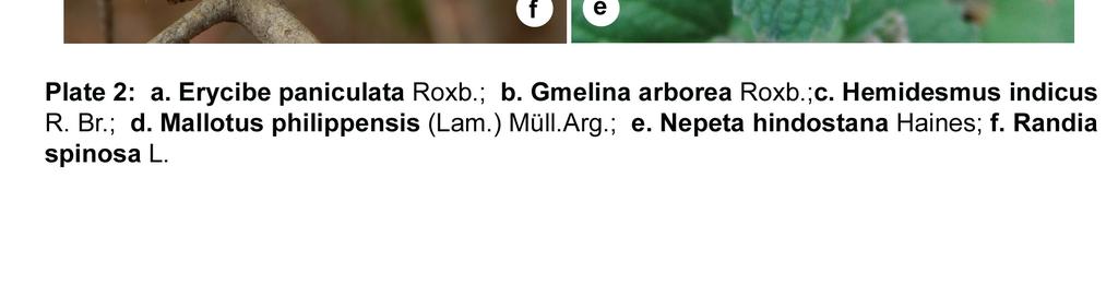
3 Photo courtesy: Vinay Ranjan


4 Photo courtesy: Vinay Ranjan
5 REFERENCES Anderson, T On the flora of Bihar and the mountains of Parasnath with a list of species collected by Messrs Hooker, Edgeworth, Thomson and Anderson. J. Asiat. Soc. Bengal, Pt. 2, Nat. Hist. 32: Bhattacharyya, P.K. & Sarkar, K Flora of West Champaran district, Bihar. Botanical Survey of India, Calcutta. Champion, H.G. & Seth, S.K A revised forest types of India. Govt. of India Publications, New Delhi. Das, M., Bhattacharya, R.P. & Mudgal, V Bihar. Mudgal, V. & Hajra, P.K. (Eds.), Floristic Diversity and Conservation Strategies in India. Vol. II: In the context of States and Union Territories. pp Botanical Survey of India, Calcutta. Haines, H.H The Botany of Bihar and Orissa. Adlard & Son, London. Jain, S.K., Banerjee, D.K. & Pal, D.C Grasses of Bihar, Orissa and West Bengal. J. Bombay Nat. Hist. Soc. 72: Mishra, A. & Agarwal, R.P Preliminary notes on plants of Darbhanga. Videha Misra, M.P., Pandey, B.N. & Misra, P.N Biological spectrum of the flora of Brachmyoni hills (Gaya). Geobios 7(2): Misra, S.K. & Jha, D Floristic in Darbhanga. Planta 2(1): Mooney, H.F Some additions to the Botany of Bihar and Orissa. Indian For. Rec. 3: Mooney, H.F Supplement to the Botany of Bihar and Orissa. Catholic Press, Ranchi. Paul, S.R Studies on the grasses of Bhagalpur district (Bihar). Indian Forester 93: Paul, S.R On the aquatic and marsh flora of Monghyr, Bihar. Botanique 4: Raizada, G Some interesting plants from Bihar. Indian J. Forest. 1: Rodgers, W.A. & Panwar, H.S Planning a Wildlife Protected Area Network in India. Vol. 1 & 2. Wildlife Institute of India, Dehra Dun. Saxena, H.O Additions to the Flora of Bihar & Orissa. J. Bombay Nat. Hist. Soc. 73:
6 Saxena, H.O Additions to the Flora of Bihar & Orissa. II. J. Bombay Nat. Hist. Soc. 75: Singh, L.B Grasses of Saharsa district, Bihar. J. Econ. Taxon. Bot. 6: Singh, M.P Flora of Patna (Dicotyledones). International Books & Periodicals Supply Service, New Delhi. Singh, N.P., Mudgal, V., Khanna, K.K., Srivastava, S.C., Sahoo, A.K., Bandapadhyay, S., Aziz, N., Das, M., Bhattacharya, R.P. & Hajra, P.K Flora of Bihar Analysis. Botanical Survey of India, Calcutta. Varma, S.K Flora of Bhagalpur Dicotyledones. Today & Tomorrow Printers & Publishers, New Delhi. Varma, S.K. & Jha, R.R Additions to the flora of Bihar. J. Bombay Nat. Hist. Soc. 89:
Natural Vegetation and Wildlife
 Natural Vegetation and Wildlife Exercise Page 51 Question 1: Choose the right answer from the four alternatives given below. (i) To which one of the following types of vegetation does rubber belong? (a)
Geographical location and climatic condition of the
 Geographical location and climatic condition of the study sites North eastern region of India is comprised of eight states namely; Arunachal Pradesh, Assam, Manipur, Meghalaya, Mizoram, Nagaland, Sikkim
Climate Change in Bihar, India:A Case Study
 Climate Change in Bihar, India:A Case Study L. B. Roy 1, M. Bhushan 2, R. Kumar 2 1,2 Civil Engineering Department, National Institute of Technology Patna Patna-800005, Bihar, India 1 lbroy@nitp.ac.in
OUR COUNTRY INDIA LOCATIONAL SETTING
 7 India is a country of vast geographical expanse. In the north, it is bound by the lofty Himalayas. The Arabian Sea in the west, the Bay of Bengal in the east and the Indian Ocean in the south, wash the
Chapter-3 GEOGRAPHICAL LOCATION, CLIMATE AND SOIL CHARACTERISTICS OF THE STUDY SITE
 Chapter-3 GEOGRAPHICAL LOCATION, CLIMATE AND SOIL CHARACTERISTICS OF THE STUDY SITE Chapter-3 GEOGRAPHICAL LOCATION, CLIMATE AND SOIL CHARACTERISTICS OF THE STUDY SITE Assam, the eastern most state of
Geography Class XI Fundamentals of Physical Geography Section A Total Periods : 140 Total Marks : 70. Periods Topic Subject Matter Geographical Skills
 Geography Class XI Fundamentals of Physical Geography Section A Total Periods : 140 Total Marks : 70 Sr. No. 01 Periods Topic Subject Matter Geographical Skills Nature and Scope Definition, nature, i)
3. HYDROMETEROLOGY. 3.1 Introduction. 3.2 Hydro-meteorological Aspect. 3.3 Rain Gauge Stations
 3. HYDROMETEROLOGY 3.1 Introduction Hydrometeorology is a branch of meteorology and hydrology that studies the transfer of water and energy between the land surface and the lower atmosphere. Detailed hydrological
Life Forms and Biological Spectrum of a Grassland Community of Bangiriposi In Odisha
 2015 IJSRST Volume 1 Issue 1 Print ISSN: 2395-6011 Online ISSN: 2395-602X Themed Section: Science and Technology Life Forms and Biological Spectrum of a Grassland Community of Bangiriposi In Odisha Prabir
Rainfall is the major source of water for
 RESEARCH PAPER: Assessment of occurrence and frequency of drought using rainfall data in Coimbatore, India M. MANIKANDAN AND D.TAMILMANI Asian Journal of Environmental Science December, 2011 Vol. 6 Issue
Spatial and Temporal Analysis of Rainfall Variation in Yadalavagu Hydrogeological unit using GIS, Prakasam District, Andhra Pradesh, India
 International Research Journal of Environment Sciences ISSN 2319 1414 Spatial and Temporal Analysis of Rainfall Variation in Yadalavagu Hydrogeological unit using GIS, Prakasam District, Andhra Pradesh,
Biomes There are 2 types: Terrestrial Biomes (on land) Aquatic Biomes (in the water)
 Aquatic Biomes (in the water)") Biomes There are 2 types: Terrestrial Biomes (on land) Aquatic Biomes (in the water) Terrestrial Biomes Grassland, Desert, and Tundra Biomes: Savanna Temperate grassland Chaparral Desert Tundra Chapter
Biomes There are 2 types: Terrestrial Biomes (on land) Aquatic Biomes (in the water) Terrestrial Biomes Grassland, Desert, and Tundra Biomes: Savanna Temperate grassland Chaparral Desert Tundra Chapter
forest tropical jungle swamp marsh prairie savanna pampas Different Ecosystems (rainforest)
") Different Ecosystems forest A region of land that is covered with many trees and shrubs. tropical jungle (rainforest) swamp A region with dense trees and a variety of plant life. It has a tropical climate.
Different Ecosystems forest A region of land that is covered with many trees and shrubs. tropical jungle (rainforest) swamp A region with dense trees and a variety of plant life. It has a tropical climate.
Tropical Moist Rainforest
 Tropical or Lowlatitude Climates: Controlled by equatorial tropical air masses Tropical Moist Rainforest Rainfall is heavy in all months - more than 250 cm. (100 in.). Common temperatures of 27 C (80 F)
UNIT 11 SOUTH ASIA SG 1 - PHYSICAL GEOGRAPHY & THE ENVIRONMENT
 UNIT 11 SOUTH ASIA SG 1 - PHYSICAL GEOGRAPHY & THE ENVIRONMENT I. PHYSICAL GEOGRAPHY TAKE OUT YOUR PHYSICAL MAP OF SOUTH ASIA A. The Himalayan Mountains form the northern boundary of the region (color
Advanced Hydrology. (Web course)
") Advanced Hydrology (Web course) Subhankar Karmakar Assistant Professor Centre for Environmental Science and Engineering (CESE) Indian Institute of Technology Bombay Powai, Mumbai 400 076 Email: skarmakar@iitb.ac.in
Advanced Hydrology (Web course) Subhankar Karmakar Assistant Professor Centre for Environmental Science and Engineering (CESE) Indian Institute of Technology Bombay Powai, Mumbai 400 076 Email: skarmakar@iitb.ac.in
Seasonal Rainfall Trend Analysis
 RESEARCH ARTICLE OPEN ACCESS Seasonal Rainfall Trend Analysis Devdatta V. Pandit Research Scholar, Dept. of SWCE, M.P.K.V, Rahuri- 413722, Ahmednagar. (M., India ABSTRACT This study aims to detect the
NCERT MULTIPLE-CHOICE QUESTIONS. 1. Which of the following countries has the highest biodiversity? a. Brazil b. South Africa c. Russia d.
 106 BIOLOGY, EXEMPLAR PROBLEMS CHAPTER 15 BIODIVERSITY AND CONSERVATION MULTIPLE-CHOICE QUESTIONS 1. Which of the following countries has the highest biodiversity? a. Brazil b. South Africa c. Russia d.
DR.M.K.K ARYA MODEL SCHOOL
 DR.M.K.K ARYA MODEL SCHOOL Sub: Social science Syllabus Class-IV Session 2018-19 Prescribed book: Candid New Trends in Social Studies Syllabus to be completed in the month of April. Chapter 1.India Our
Frequency analysis of rainfall deviation in Dharmapuri district in Tamil Nadu
 Indian Journal of Geo Marine Sciences Vol.46 (8), August 217, pp. 171-1714 Frequency analysis of rainfall deviation in Dharmapuri district in Tamil Nadu V. Rajendran 1* & R. Venkatasubramani 2 1 Department
Biodiversity-Hotspots
 GE 2211 Environmental Science and Engineering Unit II Biodiversity-Hotspots M. Subramanian Assistant Professor Department of Chemical Engineering Sri Sivasubramaniya Nadar College of Engineering Kalavakkam
Climate Classification
 Chapter 15: World Climates The Atmosphere: An Introduction to Meteorology, 12 th Lutgens Tarbuck Lectures by: Heather Gallacher, Cleveland State University Climate Classification Köppen classification:
Global Biogeography. Natural Vegetation. Structure and Life-Forms of Plants. Terrestrial Ecosystems-The Biomes
 Global Biogeography Natural Vegetation Structure and Life-Forms of Plants Terrestrial Ecosystems-The Biomes Natural Vegetation natural vegetation is the plant cover that develops with little or no human
Tree distribution and Habitat preference with respect to the Elevation, Rain and Soil type of Western-ghats region of Karnataka.
 Tree distribution and Habitat preference with respect to the Elevation, Rain and Soil type of Western-ghats region of Karnataka. INTRODUCTION: Western-ghats mountain range is one of the 34 biodiversity
Summary and Conclusions
 241 Chapter 10 Summary and Conclusions Kerala is situated in the southern tip of India between 8 15 N and 12 50 N latitude and 74 50 E and 77 30 E longitude. It is popularly known as Gods own country.
Chapter 2 Drought Hazard in Bihar
 Chapter 2 Drought Hazard in Bihar 2.1 Introduction Drought occurs when a region faces a deficiency in its water supply either surface or underground for an extended period of months or years, due to consistent
Weather and Climate in Canada. October 2 nd, 2017
 Weather and Climate in Canada October 2 nd, 2017 Big Ideas How are climate and weather in Canada influenced by geography? How do weather and climate affect the lives of Canadians? Weather and Climate
Chapter 52 An Introduction to Ecology and the Biosphere
 Chapter 52 An Introduction to Ecology and the Biosphere Ecology The study of the interactions between organisms and their environment. Ecology Integrates all areas of biological research and informs environmental
The analysis of climatic variability/weather trends (past and future) in eastern U.P.
 in eastern U.P.") 2018; SP1: 1092-1096 E-ISSN: 2278-4136 P-ISSN: 2349-8234 JPP 2018; SP1: 1092-1096 Ajit Singh AK Singh Department of Agriculture Meteorology, Narendra Deva Technology Narendra Nagar, Kumarganj, Faizabad,
2018; SP1: 1092-1096 E-ISSN: 2278-4136 P-ISSN: 2349-8234 JPP 2018; SP1: 1092-1096 Ajit Singh AK Singh Department of Agriculture Meteorology, Narendra Deva Technology Narendra Nagar, Kumarganj, Faizabad,
Evidence for Weakening of Indian Summer Monsoon and SA CORDEX Results from RegCM
 Evidence for Weakening of Indian Summer Monsoon and SA CORDEX Results from RegCM S K Dash Centre for Atmospheric Sciences Indian Institute of Technology Delhi Based on a paper entitled Projected Seasonal
Summative Assessment I
 Class: IV Time: 3 Hrs. Summative Assessment I Social Science Marks: 88 Handwriting: 2 Total: 90 1. All questions are compulsory. 2. Use crayons for colouring. General Instruction I. Multiple choice questions:
Distribution of Temperature over the National Capital Territory of Delhi - A Preliminary Report
 Distribution of Temperature over the National Capital Territory of Delhi - A Preliminary Report S.C. Bhan and Rahul Saxena India Meteorological Department, New Delhi E-mail: scbhan@yahoo.com ABSTRACT The
CHAPTER 1 INTRODUCTION
 CONTENTS Page No. CHAPTER 1 INTRODUCTION 1.1 LOCATION OF THE PROJECT 1-1 1.2 BACKGROUND 1-1 1.2.1 Previous Studies 1-2 1.2.2 NHPC Proposal 1-2 1.2.3 Work after Submission of PFR 1-3 1.3 PROJECT AREA 1-3
Bell Ringer: February 6, 2013
 Bell Ringer: Please take 5 minutes to work on/ finish PBL BIOME MAP and PBL SCAVENGER HUNT! If you are finished with this, please take 5 minutes to write any last second questions about SCIENCE FAIR TONIGHT!
Technical Note: Hydrology of the Lake Chilwa wetland, Malawi
 Technical Note: Hydrology of the Lake Chilwa wetland, Malawi Matthew McCartney June 27 Description Lake Chilwa is located in the Southern region of Malawi on the country s eastern boarder with Mozambique
Canada only has 7 of these biomes. Which biome do you think does not exist in Canada and why?
 Climate Zones and Biomes There are 8 defined biomes Permanent ice Tundra Boreal Forest Temperate deciduous forest Temperate rainforest Grassland Desert Tropical rainforest What is a biome? a major biotic
Chitra Sood, R.M. Bhagat and Vaibhav Kalia Centre for Geo-informatics Research and Training, CSK HPKV, Palampur , HP, India
 APPLICATION OF SPACE TECHNOLOGY AND GIS FOR INVENTORYING, MONITORING & CONSERVATION OF MOUNTAIN BIODIVERSITY WITH SPECIAL REFERENCE TO MEDICINAL PLANTS Chitra Sood, R.M. Bhagat and Vaibhav Kalia Centre
Dr. S. K. Basumatary, Scientist D,
 CURRICULUM VITAE Dr. S. K. Basumatary, Scientist D, M. Sc. in Botany (Special paper Microbiology), Gauhati University, Assam. Ph. D. in Palaeobotany, University of Lucknow, Uttar Pradesh, India. Quaternary
Report for Area Drainage Studies for 1320 MW (2x660 MW) THERMAL POWER PROJECT AT MIRZAPUR, U.P.
 THERMAL POWER PROJECT AT MIRZAPUR, U.P.") Report for Area Drainage Studies for 1320 MW (2x660 MW) THERMAL POWER PROJECT AT MIRZAPUR, U.P. 1. Introduction M/s Welspun Energy Uttar Pradesh Ltd. (WEUPL) is putting up 1320 MW (2 x 660 MW) coal fired
Report for Area Drainage Studies for 1320 MW (2x660 MW) THERMAL POWER PROJECT AT MIRZAPUR, U.P. 1. Introduction M/s Welspun Energy Uttar Pradesh Ltd. (WEUPL) is putting up 1320 MW (2 x 660 MW) coal fired
Biosphere Organization
 Biosphere Organization What is a biome? Biomes refer to a large region or area characterized by the following: 1. A particular climate pattern of the annual temperature and precipitation distribution,
About places and/or important events Landmarks Maps How the land is, hills or flat or mountain range Connected to maps World Different countries
 What do you think you know about geography? About places and/or important events Landmarks Maps How the land is, hills or flat or mountain range Connected to maps World Different countries What do you
Global Patterns Gaston, K.J Nature 405. Benefit Diversity. Threats to Biodiversity
 Biodiversity Definitions the variability among living organisms from all sources, including, 'inter alia', terrestrial, marine, and other aquatic ecosystems, and the ecological complexes of which they
Topographical Maps ANSWER KEY- Assignment 6
 Topographical Maps ANSWER KEY- Assignment 6 Question 1 (To be answered using toposheet 45 D/7, Grid reference 76 to 85) 1. Cite two differences between the Sipu River and the Mahadeviyo Nala? Sipu River
Climates of NYS. Definitions. Climate Regions of NYS. Storm Tracks. Climate Controls 10/13/2011. Characteristics of NYS s Climates
 Definitions Climates of NYS Prof. Anthony Grande 2011 Weather and Climate Weather the state of the atmosphere at one point in time. The elements of weather are temperature, air pressure, wind and moisture.
Rainfall variation and frequency analysis study of Salem district Tamil Nadu
 Indian Journal of Geo Marine Sciences Vol. 46 (1), January 217, pp. 213-218 Rainfall variation and frequency analysis study of Salem district Tamil Nadu Arulmozhi.S 1* & Dr. Prince Arulraj.G 2 1 Department
ARGEMONE OCHROLEUCA (PAPAVERACEAE) NATURALIZED IN DAHOD DISTRICT, GUJARAT, INDIA
 NATURALIZED IN DAHOD DISTRICT, GUJARAT, INDIA") Patel, P.K. 2013. Argemone ochroleuca (Papaveraceae) naturalized in Dahod District, Gujarat, India. Phytoneuron 2013-52: 1 5. Published 25 July 2013. ISSN 2153 733X ARGEMONE OCHROLEUCA (PAPAVERACEAE) NATURALIZED
Patel, P.K. 2013. Argemone ochroleuca (Papaveraceae) naturalized in Dahod District, Gujarat, India. Phytoneuron 2013-52: 1 5. Published 25 July 2013. ISSN 2153 733X ARGEMONE OCHROLEUCA (PAPAVERACEAE) NATURALIZED
Technical Note: Hydrology of the Lukanga Swamp, Zambia
 Technical Note: Hydrology of the Lukanga Swamp, Zambia Matthew McCartney July 7 Description The Lukanga swamp is located approximately 5km west of the city of Kabwe, in the Central province of Zambia,
Group Name: Herbarium- A National Facility. Group Works on: 1. Objectives
 Group Name: Herbarium- A National Facility Group Works on: 1. Objectives Herbarium is a place, where plants collected from far and wide are preserved in pressed and dried condition and are kept in pigeon
Analysis of Rainfall and Other Weather Parameters under Climatic Variability of Parbhani ( )
") International Journal of Current Microbiology and Applied Sciences ISSN: 2319-7706 Volume 7 Number 06 (2018) Journal homepage: http://www.ijcmas.com Original Research Article https://doi.org/10.20546/ijcmas.2018.706.295
International Journal of Current Microbiology and Applied Sciences ISSN: 2319-7706 Volume 7 Number 06 (2018) Journal homepage: http://www.ijcmas.com Original Research Article https://doi.org/10.20546/ijcmas.2018.706.295
Name Period Date. Analyzing Climographs
 Name Period Date Analyzing Climographs Climographs: It is often helpful to plot two different types of data on the same graph. For example, a climograph is a single graph that charts both the average temperature
APPENDIX TABLE 1 Expansion of the National Malaria Control Program Population protected. # Units established (cumulative)
") Appendix A.1. The National Malaria Control Program APPENDIX TABLE 1 Expansion of the National Malaria Control Program Population protected # Units established # Units established (cumulative) (cumulative,
Appendix A.1. The National Malaria Control Program APPENDIX TABLE 1 Expansion of the National Malaria Control Program Population protected # Units established # Units established (cumulative) (cumulative,
Detailed Syllabus in Geography for B.A/ B. Sc Semester- III under CBCS for the Examination to be held in December 2017, 2018 and 2019
 Detailed Syllabus in Geography for B.A/ B. Sc Semester- III under CBCS for the Examination to be held in December 2017, 2018 and 2019 Course Code: UGOTC- 301 (Theory Core) Title: Physical Geography- II
Zoogeographic Regions. Reflective of the general distribution of energy and richness of food chemistry
 Terrestrial Flora & Fauna Part II In short, the animal and vegetable lines, diverging widely above, join below in a loop. 1 Asa Gray Zoogeographic Regions Reflective of the general distribution of energy
Study of Hydrometeorology in a Hard Rock Terrain, Kadirischist Belt Area, Anantapur District, Andhra Pradesh
 Open Journal of Geology, 2012, 2, 294-300 http://dx.doi.org/10.4236/ojg.2012.24028 Published Online October 2012 (http://www.scirp.org/journal/ojg) Study of Hydrometeorology in a Hard Rock Terrain, Kadirischist
GLOBAL CLIMATES FOCUS
 which you will learn more about in Chapter 6. Refer to the climate map and chart on pages 28-29 as you read the rest of this chapter. FOCUS GLOBAL CLIMATES What are the major influences on climate? Where
Ecosystems Chapter 4. What is an Ecosystem? Section 4-1
 Ecosystems Chapter 4 What is an Ecosystem? Section 4-1 Ecosystems Key Idea: An ecosystem includes a community of organisms and their physical environment. A community is a group of various species that
Probability models for weekly rainfall at Thrissur
 Journal of Tropical Agriculture 53 (1) : 56-6, 015 56 Probability models for weekly rainfall at Thrissur C. Laly John * and B. Ajithkumar *Department of Agricultural Statistics, College of Horticulture,
BOARD OF SECONDARY EDUCATION (AP) SUMMATIVE ASSESSMENT - I TENTH SOCIAL MODEL PAPER PAPER - I (ENGLISH VERSION) SECTION - I
 SUMMATIVE ASSESSMENT - I TENTH SOCIAL MODEL PAPER PAPER - I (ENGLISH VERSION) SECTION - I") BOARD OF SECONDARY EDUCATION (AP) SUMMATIVE ASSESSMENT - I TENTH SOCIAL MODEL PAPER PAPER - I (ENGLISH VERSION) Time: 2 hrs. 45 mins. PART - A& B Maximum Marks: 40 Time: 2 hrs. 15 mins. PART - A Marks:
BOARD OF SECONDARY EDUCATION (AP) SUMMATIVE ASSESSMENT - I TENTH SOCIAL MODEL PAPER PAPER - I (ENGLISH VERSION) Time: 2 hrs. 45 mins. PART - A& B Maximum Marks: 40 Time: 2 hrs. 15 mins. PART - A Marks:
Module 11: Meteorology Topic 3 Content: Climate Zones Notes
 Introduction Latitude is such an important climate factor that you can make generalizations about a location's climate based on its latitude. Areas near the equator or the low latitudes are generally hot
Cephalostachyum capitatum var. decompositum Gamble (Poaceae-Bambuseae): separation, lectotypification, and conservation status
: separation, lectotypification, and conservation status") Cephalostachyum capitatum var. decompositum Gamble (Poaceae-Bambuseae): separation, lectotypification, and conservation status C. M. A. Stapleton 1 Abstract: The identity and of a supposedly rare and threatened
Cephalostachyum capitatum var. decompositum Gamble (Poaceae-Bambuseae): separation, lectotypification, and conservation status C. M. A. Stapleton 1 Abstract: The identity and of a supposedly rare and threatened
Chapter 1 Data Collection
 Chapter 1 Data Collection 1. Climate of Brunei Darussalam and Temburong District Situated at around four degrees north of the Equator, Brunei Darussalam enjoys an equatorial climate with an abundance of
Impact of Urbanisation: A Comparative Overview of Four Mega Cities in India
 e t International Journal on Emerging Technologies 8(1): 375-38(217) ISSN No. (Print) : 975-8364 ISSN No. (Online) : 2249-3255 Impact of Urbanisation: A Comparative Overview of Four Mega Cities in India
The Impact of Geography in South and East Asia
 The Impact of Geography in South and East Asia Gobi desert, Mongolia Essential Question: How does the geography of SE Asia impact trade and the distribution of population throughout the region? (AKS #52a)
Climate Chapter 19. Earth Science, 10e. Stan Hatfield and Ken Pinzke Southwestern Illinois College
 Climate Chapter 19 Earth Science, 10e Stan Hatfield and Ken Pinzke Southwestern Illinois College The climate system A. Climate is an aggregate of weather B. Involves the exchanges of energy and moisture
World Geography Chapter 3
 World Geography Chapter 3 Section 1 A. Introduction a. Weather b. Climate c. Both weather and climate are influenced by i. direct sunlight. ii. iii. iv. the features of the earth s surface. B. The Greenhouse
How does the physical environment influence communities and ecosystems? Hoodoos in Cappadocia, Turkey
 Biomes of the World How does the physical environment influence communities and ecosystems? Hoodoos in Cappadocia, Turkey ecosystems are shaped by: abiotic factors climate/weather space Rainfall Soil air
TEST NAME: Biome Test 10/7 TEST ID: GRADE:05 - Fifth Grade SUBJECT:Life and Physical Sciences TEST CATEGORY: My Classroom
 TEST NAME: Biome Test 10/7 TEST ID:1239163 GRADE:05 - Fifth Grade SUBJECT:Life and Physical Sciences TEST CATEGORY: My Classroom Biome Test 10/7 Page 1 of 8 10/07/16, Biome Test 10/7 Student: Class: Date:
Rainfall variation and frequency analysis study in Dharmapuri district, India
 Indian Journal of Geo Marine Sciences Vol. 45 (11), November 216, pp. 156-1565 Rainfall variation and frequency analysis study in Dharmapuri district, India V. Rajendran 1*, R. Venkatasubramani 2 & G.
Definitions Weather and Climate Climates of NYS Weather Climate 2012 Characteristics of Climate Regions of NYS NYS s Climates 1.
 Definitions Climates of NYS Prof. Anthony Grande 2012 Weather and Climate Weather the state of the atmosphere at one point in time. The elements of weather are temperature, t air pressure, wind and moisture.
STUDIES ON PHENOLOGICAL CHARACTERISTICS OF DIFFERENT FOREST TREES OF SOUTH GUJARAT, INDIA
 Plant Archives Vol. 14 No. 2, 2014 pp. 1015-1021 ISSN 0972-5210 STUDIES ON PHENOLOGICAL CHARACTERISTICS OF DIFFERENT FOREST TREES OF SOUTH GUJARAT, INDIA Vikas Kumar*, Ruchit Patel 1, Sachin Kumar Singh
Georgia Performance Standards for Urban Watch Restoration Field Trips
 Georgia Performance Standards for Field Trips 6 th grade S6E3. Students will recognize the significant role of water in earth processes. a. Explain that a large portion of the Earth s surface is water,
INTERNATIONAL JOURNAL OF ENVIRONMENTAL SCIENCES Volume 1, No 7, 2011
 INTERNATIONAL JOURNAL OF ENVIRONMENTAL SCIENCES Volume 1, No 7, 2011 2011 Sudhakar Reddy.C et al., licensee IPA- Open access - Distributed under Creative Commons Attribution License 2.0 Research article
MAURITIUS METEOROLOGICAL SERVICES
 MAURITIUS METEOROLOGICAL SERVICES CLIMATE SEPTEMBER 2018 Introduction Synoptic weather pattern over the region portrayed September as a transition month. The month started with wintry characteristics.
Chiang Rai Province CC Threat overview AAS1109 Mekong ARCC
 Chiang Rai Province CC Threat overview AAS1109 Mekong ARCC This threat overview relies on projections of future climate change in the Mekong Basin for the period 2045-2069 compared to a baseline of 1980-2005.
Lecture Outlines PowerPoint. Chapter 20 Earth Science 11e Tarbuck/Lutgens
 Lecture Outlines PowerPoint Chapter 20 Earth Science 11e Tarbuck/Lutgens 2006 Pearson Prentice Hall This work is protected by United States copyright laws and is provided solely for the use of instructors
Name Date Class. well as the inland, found near the Tropics. 4. In the, or the regions near the Equator, you may find a lush
 WATER, CLIMATE, AND VEGETATION Vocabulary Activity DIRECTIONS: Fill in the Blanks Select a term from below to complete each of the following sentences. CHAPTER 1. The constant movement of water, a process
Dry spell analysis for effective water management planning
 www.ijaser.com 2012 by the authors Licensee IJASER- Under Creative Commons License 3.0 editorial@ijaser.com Research article ISSN 2277 9442 Dry spell analysis for effective water management planning Kandasamy
Monthly Overview. Rainfall
 Monthly Overview Weather news during February 2017 was dominated by the arrival of Tropical Cyclone Dineo, the first cyclone to make landfall over southern Africa since cyclone Eline in February 2000.
National Wildland Significant Fire Potential Outlook
 National Wildland Significant Fire Potential Outlook National Interagency Fire Center Predictive Services Issued: September, 2007 Wildland Fire Outlook September through December 2007 Significant fire
Our climate system is based on the location of hot and cold air mass regions and the atmospheric circulation created by trade winds and westerlies.
 CLIMATE REGIONS Have you ever wondered why one area of the world is a desert, another a grassland, and another a rainforest? Or have you wondered why are there different types of forests and deserts with
MAURITIUS METEOROLOGICAL SERVICES
 MAURITIUS METEOROLOGICAL SERVICES CLIMATE NOVEMBER 2018 Introduction Climatologically speaking, November is a relatively dry month for Mauritius with a long term monthly mean rainfall of 78 mm. However,
CLASS VI GEOGRAPHY FORTNIGHTLY SYLLABUS NEW SESSION 2 ND APRIL Sub Topic. Introduction- The different celestial bodies.
 CLASS VI GEOGRAPHY FORTNIGHTLY SYLLABUS 08-09 NEW SESSION ND APRIL 08 S. No Fortnight Days Main Topic. nd April 3 th April Chapter The Earth in the Solar system Sub Topic - The different celestial bodies
Long Range Forecast Update for 2014 Southwest Monsoon Rainfall
 Earth System Science Organization (ESSO) Ministry of Earth Sciences (MoES) India Meteorological Department PRESS RELEASE New Delhi, 9 June 2014 Long Update for 2014 Southwest Monsoon Rainfall HIGHLIGHTS
Lesson- 6 WEATHER AND CLIMATE
 Lesson- 6 WEATHER AND CLIMATE New Words 1. Heat Zones:- the division of the earth according to the climate. 2. Frigid:- the zone that is the coldest 3. Temperate:- the zone that is neither too hot nor
Vegetative phenology of three bamboo species in subtropical humid climate of Assam
 NATH, DAS & DAS 85 Tropical Ecology 49(1): 85-89, 2008 ISSN 0564-3295 International Society for Tropical Ecology www.tropecol.com Vegetative phenology of three bamboo species in subtropical humid climate
CURRENT STATUS OF MONSOON Main Meteorological conditions of the last week (27August to 2 September)
") CURRENT STATUS OF MONSOON 2009 Main Meteorological conditions of the last week (27August to 2 September) Last week s low pressure area over Orissa and neighbourhood moved west-northwestwards across central
CURRENT STATUS OF MONSOON 2009 Main Meteorological conditions of the last week (27August to 2 September) Last week s low pressure area over Orissa and neighbourhood moved west-northwestwards across central
Queensland Floods- Part A
 Queensland Floods- Part A Floods Flooding is when the water level in a creek, river, lake or the sea rises and covers land that is normally dry. The rise in water can be due to numerous causes, although
Unit 1: Geography GeoTrekkers in the Western Hemisphere. Illustrated Glossary
 Unit 1: Geography GeoTrekkers in the Western Hemisphere Illustrated Glossary adapt to change in order to fit new condi/ons archipelago a group or chain of islands clustered together in a sea or ocean bodies
Weekly Rainfall Analysis and Markov Chain Model Probability of Dry and Wet Weeks at Varanasi in Uttar Pradesh
 885 Environment & Ecology 32 (3) : 885 890, July September 2014 Website: environmentandecology.com ISSN 0970-0420 Weekly Rainfall Analysis and Markov Chain Model Probability of Dry and Wet Weeks at Varanasi
Exploring the World s Cultures 90 Minute Social Studies Lesson Gallery Program Grades: 3-7. Exploring the World s Cultures. Description.
 TEACHER GUIDE Exploring the World s Cultures 90 Minute Social Studies Lesson Gallery Program Grades: 3-7 Exploring the World s Cultures Description Travel the world and connect with cultures with which
ABSTRACT One of the serious problems that India facing today is the problem of regional disparities. It results in social, economic and political
 ABSTRACT One of the serious problems that India facing today is the problem of regional disparities. It results in social, economic and political instability. The current tension and strain in the Indian
Abstract. TECHNOFAME- A Journal of Multidisciplinary Advance Research. Vol.2 No. 2, (2013) Received: Feb.2013; Accepted Oct.
 Received: Feb.2013; Accepted Oct.") Vol.2 No. 2, 83-87 (2013) Received: Feb.2013; Accepted Oct. 2013 Landuse Pattern Analysis Using Remote Sensing: A Case Study of Morar Block, of Gwalior District, M.P. Subhash Thakur 1 Akhilesh Singh 2
Vol.2 No. 2, 83-87 (2013) Received: Feb.2013; Accepted Oct. 2013 Landuse Pattern Analysis Using Remote Sensing: A Case Study of Morar Block, of Gwalior District, M.P. Subhash Thakur 1 Akhilesh Singh 2
By: J Malherbe, R Kuschke
 2015-10-27 By: J Malherbe, R Kuschke Contents Summary...2 Overview of expected conditions over South Africa during the next few days...3 Significant weather events (27 October 2 November)...3 Conditions
Biomes. Biomes Are Life Zones
 Biomes Biomes Are Life Zones Biomes They Include All Plants Animals Other Organisms The Physical Environment In A Particular Area Biomes A Biome Is Characterized By Its Plant Life Biomes These Types Are
DROUGHT RISK EVALUATION USING REMOTE SENSING AND GIS : A CASE STUDY IN LOP BURI PROVINCE
 DROUGHT RISK EVALUATION USING REMOTE SENSING AND GIS : A CASE STUDY IN LOP BURI PROVINCE K. Prathumchai, Kiyoshi Honda, Kaew Nualchawee Asian Centre for Research on Remote Sensing STAR Program, Asian Institute
Meteorology. Chapter 15 Worksheet 1
 Chapter 15 Worksheet 1 Meteorology Name: Circle the letter that corresponds to the correct answer 1) The Tropic of Cancer and the Arctic Circle are examples of locations determined by: a) measuring systems.
CLIMATE. UNIT TWO March 2019
 CLIMATE UNIT TWO March 2019 OUTCOME 9.2.1Demonstrate an understanding of the basic features of Canada s landscape and climate. identify and locate major climatic regions of Canada explain the characteristics
The Impact of Geography in South and East Asia
 The Impact of Geography in South and East Asia Gobi desert, Mongolia Essential Question: How does the geography of SE Asia impact trade and the distribution of population throughout the region? (AKS #52a)
Spheres of Life. Ecology. Chapter 52. Impact of Ecology as a Science. Ecology. Biotic Factors Competitors Predators / Parasites Food sources
 "Look again at that dot... That's here. That's home. That's us. On it everyone you love, everyone you know, everyone you ever heard of, every human being who ever was, lived out their lives. Ecology Chapter
CHAPTER VI GENERAL CONCLUSION
 CHAPTER VI GENERAL CONCLUSION Kerala is situated on the southwest, wet side of the Western Ghats, one of the biodiversity hot spots of the world. Many studies are there on algae of different localities
Biomes Section 2. Chapter 6: Biomes Section 2: Forest Biomes DAY ONE
 Chapter 6: Biomes Section 2: Forest Biomes DAY ONE Of all the biomes in the world, forest biomes are the most widespread and the most diverse. The large trees of forests need a lot of water, so forests