March 11, 2011 Japanese Tsunami
|
|
|
- Peregrine Campbell
- 6 years ago
- Views:
Transcription


1 John Fassell

2 March 11, 2011 Japanese Tsunami

3 An earthquake occurred 30 miles under ground which lifted the seafloor

4 Incoming wave as seen from shore

5 Tsunami up to 130 feet tall in Miyako, JA that averaged more than 30 feet tall

6 Tsunami averaging 23 feet tall coming into Ishinomaki, JA. Trees are 50 feet

7 Isinomaki tsunami at a different angle

8 Ishinomaki a few seconds later

9 Incoming wavefront slowly flooding

10 Tsunami wavefront paths in Pacific

11 Tsunami arriving in San Francisco Bay

12 Whirlpools in outflowing tidal surge

13 Tsunami surge and ebb of aftershocks

14 Tsunami aftershock surging

15

16 Miyako shoreline road after tsunami

17 Ferryboat left behind on apartments

18 Fires in the aftermath

19 Many thousand were never found

20 Rescue efforts saved many animals
21 Types of Nuclear Power Plants Pressurized Water Reactor Graphite Moderated Core Chernobyl, Ukraine Boiling Water Reactor Fukushima Daiichi Pressurized Water Reactor Diablo Canyon, SONGS, Three Mile Island

22 Japan
23

24

25
26


27
28
29

30 San Onofre Nuclear Generating Station San Clemente, CA

31 Diablo Canyon Nuclear Power Plant Avila Beach, CA

32 Debris field on land

33 Major currents in Pacific Ocean

34 Estimated debris field in ocean

35 Estimated debris field in ocean

36 Observed debris field as of 4/2012

37 Observed debris field in ocean

38 Floating debris in ocean

39 Derelict fishing boat off British Columbia

40 Marine debris from the tsunami

41 Cargo containers in railyard near ocean

42 Harley Davidson found in cargo container that washed up in Alaska

43 Dock landed at Newport, Oregon

44 Remedial measures to minimize exotic species introduction
45 Response to the debris issue Federally the players are the EPA, NOAA, FEMA, USCG At the state level the agencies are CDPH, CALEPA, and CALEMA Locally the responders are fire and police
46 Federal Responders EPA Environmental Protection Agency is the lead agency for the whole effort They run the marine debris cleanup program at a national level NOAA National Oceanic and Atmospheric Administration provides weather and oceanographic observation and forecasting services. They have models specific to tracking floating materials in the ocean. FEMA Federal Emergency Management Agency helps coordinate federal emergency response efforts. In this case they are providing some support to marshaling federal resources in support of the effort USCG United States Coast Guard provides enforcement of maritime law and responds to water related hazards. They provide waterborne assistance specific to dealing with maritime hazards.
47 State and Local Responders CALEPA California Environmental Protection Agency is the lead agency for the California effort. They run the California marine debris cleanup program on a day to day basis along with controlling state storm water runoff CDPH California Department of Public Health includes the Radiologic Health Branch which provides manpower and technical support in dealing with radiological issues such as may be posed by Fukushima debris. CALEMA California Emergency Management Agency helps coordinate state emergency response efforts. In this case they are providing support to marshaling various resources in support of the effort. Local police and fire departments provide on scene disaster control and HAZMAT response by fully trained and equipped crews.
48 CDPH Response So far CDPH has appointed a liason to deal with the tsunami debris issue CDPH responded to the needs for public information during the Fukushima nuclear meltdown. The radioactive plume that resulted was tracked by RHB staff. Samples of many environmental media were analyzed and showed detectable results but nothing to raise any public health concerns. CDPH is coordinating the public messaging with CALEPA and CALEMA for consistency to public and emergency responders. CDPH has helped write procedures for the local HAZMAT responders for dealing with potentially radioactive debris.
49 CDPH HAZMAT Guidance Other hazards are far, far more likely to take precedence over the radioactive hazard, if any, so normal HAZMAT procedures should be followed If radioactive contamination is suspected based on markings on a package contact CALEMA for normal routing of a call to get to RHB Any contamination from Fukushima will have decayed away or washed off the objects by now Any powerful radioactive source is encased in a heavy lead or tungsten container. So unless it is floating around in a cargo container it s probably at the bottom of the ocean just off Japan.

50
"The Big One" by sea and not by land
 "The Big One" by sea and not by land By Los Angeles Times, adapted by Newsela staff on 03.24.14 Word Count 629 Surfer Lee Johnson emerges from the water at San Onofre State Beach, Calif., with the twin
Earthquake Hazards. Tsunami
 Earthquake Hazards Tsunami Measuring Earthquakes Two measurements that describe the power or strength of an earthquake are: Intensity a measure of the degree of earthquake shaking at a given locale based
Earthquake Hazards. Tsunami
 Earthquake Hazards Tsunami Review: What is an earthquake? Earthquake is the vibration (shaking) and/or displacement of the ground produced by the sudden release of energy. The point inside the Earth where
Prevention Tsunami wall 10m high (breached by the tsunami due to land level falling by 3m)
") Plate margin Plates Causes Sendai, Japan Convergent plate margin Pacific and Eurasian Plates Convergent plate margin Sima (Pacific plate) moves towards the sial (Eurasian plate) Sima (Pacific plate) is
Plate margin Plates Causes Sendai, Japan Convergent plate margin Pacific and Eurasian Plates Convergent plate margin Sima (Pacific plate) moves towards the sial (Eurasian plate) Sima (Pacific plate) is
Unit 9 (packet #2): Volcanoes and Earthquakes
: Volcanoes and Earthquakes") Unit 9 (packet #2): Volcanoes and Earthquakes 13. Earthquakes are one of the most destructive natural forces. I can a. Explain what an earthquake is, where they occur and why they occur. b. Describe the
Unit 9 (packet #2): Volcanoes and Earthquakes 13. Earthquakes are one of the most destructive natural forces. I can a. Explain what an earthquake is, where they occur and why they occur. b. Describe the
DRAFT - Tsunami Response Plan Playbook Santa Cruz Harbor Maritime Community
 DRAFT - Tsunami Response Plan Playbook Santa Cruz Harbor Maritime Community Page 1 Best to display on 11X17 paper Purpose and Use of this Real-time Tsunami Response Plan Playbook PURPOSE: This product
Darren Wright Maritime Services Program Manager Center for Operational Oceanographic Products and Services (CO-OPS)
") Darren Wright Maritime Services Program Manager Center for Operational Oceanographic Products and Services (CO-OPS) Center for Operational Oceanographic Products and Services (CO-OPS) National Water Level
Darren Wright Maritime Services Program Manager Center for Operational Oceanographic Products and Services (CO-OPS) Center for Operational Oceanographic Products and Services (CO-OPS) National Water Level
Earthquake Hazards. Tsunami
 Earthquake Hazards Tsunami Review: What is an earthquake? Earthquake is the vibration (shaking) and/or displacement of the ground produced by the sudden release of energy. The point inside the Earth where
Introduction to Environmental Geology, 5e Case History: Indonesian Tsunami Indonesian Tsunami (2) Introduction Historic Tsunamis
 Introduction Historic Tsunamis") 1 2 3 4 5 6 7 8 9 Introduction to Environmental Geology, 5e Chapter 7 Tsunami Case History: Indonesian Tsunami December 26, 2004, within a few hours, close to 250,000 people were killed With no warning
1 2 3 4 5 6 7 8 9 Introduction to Environmental Geology, 5e Chapter 7 Tsunami Case History: Indonesian Tsunami December 26, 2004, within a few hours, close to 250,000 people were killed With no warning
Introduction to Environmental Geology, 5e
 Lecture Presentation prepared by X. Mara Chen, Salisbury University Introduction to Environmental Geology, 5e Edward A. Keller Chapter 7 Tsunami Case History: Indonesian Tsunami December 26, 2004, within
Cascadia Seismic Event Planning for the Maritime Community
 Cascadia Seismic Event Planning for the Maritime Community Jonathan Allan, Oregon Dept. of Geology and Mineral Industries Presentation to Annual Pacific Northwest Waterways Association Meeting (PNWA) October
Response Case Study: April 2014 Historic Flood Event. Severe Weather April 29 30, 2014
 Response Case Study: April 2014 Historic Flood Event NOAA s Regional Preparedness Training (NRPT) Natural Disaster Causing Technology Disasters in Mobile Bay Area Kimberly Albins Gulf of Mexico Regional
Tohoku Earthquake and Tsunami Japan March 11, 2011 Information updated 4/19/2011
 Tohoku Earthquake and Tsunami Japan March 11, 2011 Information updated 4/19/2011 On March 11, 2011 a massive earthquake occurred on the ocean floor south of the northeastern Tohoku region of the Japanese
What is a tsunami? Capital Regional District Tsunami Frequently Asked Questions (FAQ s) Tsunami (soo-nah-mee)
 Tsunami (soo-nah-mee)") Tsunami (soo-nah-mee) Tsunamis (Japanese translation harbour wave ) are waves with a great distance between crests, and are caused by any widespread, sudden movement of large volumes of water. The tsunami
Tsunami (soo-nah-mee) Tsunamis (Japanese translation harbour wave ) are waves with a great distance between crests, and are caused by any widespread, sudden movement of large volumes of water. The tsunami
Modeling Radiological Consequences of Sever Accidents in BWRs: Review of Models Development, Verification and Validation
 Modeling Radiological Consequences of Sever Accidents in BWRs: Review of Models Development, Verification and Validation Mohamed GAHEEN Department of Research on Nuclear Safety and Radiological Emergencies,
IG-WRDRR, UNESCAP, UNESCO-IOC, WMO. Yukio Tamura Chairman, International. Group. Tuesday 10 May, , Room 13. for Disaster. Risk.
 Side Event: Saving of Lives and Improved Coastal Risk Management through Regional Cooperation in Ocean and Marine Related Early Warning Systems in Asia Tuesday 10 May, 13.15 14.15, Room 13 IG-WRDRR, UNESCAP,
(energy loss is greater with longer wavelengths)
") GEOL 0820 Ramsey Natural Disasters Spring, 2018 LECTURE #9: Tsunami Monitoring & Mitigation Date: 8 February 2018 I. Characteristics (con t): shoaling: o process of wave height increase and breaking as
GEOL 0820 Ramsey Natural Disasters Spring, 2018 LECTURE #9: Tsunami Monitoring & Mitigation Date: 8 February 2018 I. Characteristics (con t): shoaling: o process of wave height increase and breaking as
Hurricane Florence: Rain this heavy comes along once every 1,000 years
 Hurricane Florence: Rain this heavy comes along once every 1,000 years By Associated Press, adapted by Newsela staff on 09.17.18 Word Count 786 Level 810L Image 1. This satellite image provided by the
Hurricane Katrina and Oil Spills: Impact on Coastal and Ocean Environments
 Archived version from NCDOCKS Institutional Repository http://libres.uncg.edu/ir/asu/ Pine, J. C. (June 2006). Hurricane Katrina and oil spills: Impact on coastal and ocean environments. Oceanography,
Financial concerns Regulatory developments Superfund, Resource Conservation and Recovery Act (RCRA) frame Industry Reactions
 frame Industry Reactions") Hazardous Materials Management Background Episodic Events: 1979 - Three Mile Island - Harrisburg, Pennsylvania Partial meltdown of radioactive core Lessons Technological systems can fail in unexpected
Hazardous Materials Management Background Episodic Events: 1979 - Three Mile Island - Harrisburg, Pennsylvania Partial meltdown of radioactive core Lessons Technological systems can fail in unexpected
SITUATION REPORT. Hurricane Nate. Operational Period: October 8, to October 9,
 SITUATION REPORT Hurricane Nate Operational Period: October 8, 2017 0800 to October 9, 2017 0759 CURRENT SITUATION 2:00 p.m. Briefing Hurricane Nate WEATHER SUMMARY All watches and warnings discontinued.
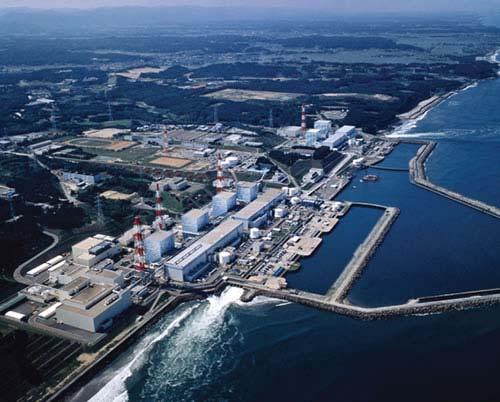
Fukushima nuclear power plant damaged by M9 Earthquake with some focus on ocean
 Fukushima nuclear power plant damaged by M9 Earthquake with some focus on ocean Moto Ikeda (Hokkaido Univ. & JAMSTEC) Oceanographic Society of Japan, Earthquake Disaster Working Group Magnitude-9 earthquake
Linkage to the National Program
 Linkage to the National Program Frank González Pacific Marine Environmental Laboratory Seattle, WA Frank González, NOAA TIME Center, PMEL, Seattle, WA NOAA is about FORECASTS and WARNINGS -Hurricanes Sunspots
Disclaimer. This report was compiled by an ADRC visiting researcher (VR) from ADRC member countries.
 from ADRC member countries.") Disclaimer This report was compiled by an ADRC visiting researcher (VR) from ADRC member countries. The views expressed in the report do not necessarily reflect the views of the ADRC. The boundaries and
Disclaimer This report was compiled by an ADRC visiting researcher (VR) from ADRC member countries. The views expressed in the report do not necessarily reflect the views of the ADRC. The boundaries and
Trainee Manual C02 CITY OF SASKATOON. Water and Sewer Section. Severe Storm Response Trainee Manual. Version # 1-0-3
 Trainee Manual C02 CITY OF SASKATOON Water and Sewer Section Severe Storm Response Trainee Manual CITY OF SASKATOON Severe Storm Response Trainee Manual City of Saskatoon Severe Storm Response Trainees
Correlating Radioactive Material to Sea Surface Temperature off the Coast of Japan: The Fukushima Daiichi Nuclear Disaster. Maya R.
 Correlating Radioactive Material to Sea Surface Temperature off the Coast of Japan: The Fukushima Daiichi Nuclear Disaster Maya R. Pincus Department of Geology, University of Puerto Rico-Mayagüez e-mail:
Not all eruptions are the same. Sometimes, there is a huge explosion. The hot magma shoots
 Natural Disasters A natural disaster is an event that happens in nature. It is an event that can cause a lot of damage. Volcanoes, earthquakes, and tsunamis are all natural disasters. Volcanoes A volcano
Lessons learned in responding to the accident at the Fukushima Daiichi nuclear power stations: THE WAY FORWARD
 WMO World Meteorological Organization Working together in weather, climate and water Lessons learned in responding to the accident at the Fukushima Daiichi nuclear power stations: THE WAY FORWARD WMO:
What Are Disasters? The Rescue Kids Trio!
 The Rescue Kids Trio! What Are Disasters? This manual was made possible through funding by the Council of Local Authorities for International Relations. Disasters and emergency preparedness Emergency preparedness
2015 Hurricane Season Outlook and Preparedness. Amy Godsey State Meteorologist State Emergency Response Team Florida Division of Emergency Management
 2015 Hurricane Season Outlook and Preparedness Amy Godsey State Meteorologist State Emergency Response Team Florida Division of Emergency Management 2015 Hurricane Season Last Hurricane Landfall: Kate
Coastal Response Research Center. Nancy Kinner University of New Hampshire (UNH) Michele Jacobi NOAA ORR. September 27, 2007
 Michele Jacobi NOAA ORR. September 27, 2007") Coastal Response Research Center Nancy Kinner University of New Hampshire (UNH) Michele Jacobi NOAA ORR September 27, 2007 1 Coastal Response Research Center (CRRC) CRRC is partnership between NOAA s Office
Coastal Response Research Center Nancy Kinner University of New Hampshire (UNH) Michele Jacobi NOAA ORR September 27, 2007 1 Coastal Response Research Center (CRRC) CRRC is partnership between NOAA s Office
Preparing for the BIG one Cascadia Subduction Zone Event
 Preparing for the BIG one Cascadia Subduction Zone Event Source - 2016 CZS Excercise updated Jan 2015 1 Earthquake Faults in Washington State Emergency Management Ring of Fire The Ring of Fire accounts
COMMUNITY EMERGENCY RESPONSE TEAM FLOODS INTRODUCTION
 INTRODUCTION Floods are one of the most common hazards in the United States. A flood occurs any time a body of water rises to cover what is usually dry land. Flood effects can be local, impacting a neighborhood
Please give me the background details of the warning system the US had before and the new improvements now.
 ----- Original Message ----- From: VADM Conrad C. Lautenbacher Jr., USN (Ret.) To: Announcement@noaa.gov Sent: Friday, January 28, 2005 1:30 PM Subject: Message from the Under Secretary -- NOAA Tsunami
Parish of Ascension. ASCENSION PARISH SITUATIONAL REPORT 06 August 2008 As of: 1600 Hours
 Parish of Ascension OFFICE OF HOMELAND SECURITY AND EMERGENCY PREPAREDNESS Tommy Martinez Parish President Richard A. Webre Director ASCENSION PARISH SITUATIONAL REPORT 06 August 2008 As of: 1600 Hours
Announcements. Projected Energy Consumption. Fossil fuel issues. By the end of class today
 Announcements Projected Energy Consumption Ecological Footprint assignment starts this afternoon to be completed by 10 AM Thursday Today: Alternatives to fossil fuels? Nuclear power Energy efficiency Thursday:
Southington. Challenges
 Southington Southington, similar to its next-door neighbor Berlin, is a suburban community in the southeast part of the region. Originally an agricultural community, Southington has also hosted industry
TXWARN Tabletop Exercise: Hurricane Helen
 TXWARN Tabletop Exercise: Hurricane Helen July 31, 2015 Administrative Details In-studio participants and remote participants Situation manual Evaluations Training hours 1 In Studio: Welcome and Introductions
Seismic Activity and Crustal Deformation after the 2011 Off the Pacific Coast of Tohoku Earthquake
 J-RAPID Symposium March 6-7, 2013 Seismic Activity and Crustal Deformation after the 2011 Off the Pacific Coast of Tohoku Earthquake Y. Honkura Tokyo Institute of Technology Japan Science and Technology
Surviving Tsunamis on the Oregon Coast
 Slide 1 Surviving Tsunamis on the Oregon Coast Coastal Engineers Think Inside the Box This talk generally covers civil engineering, coastal engineering, and how engineers work within limitations to create
Hurricane Preparation and Recovery. October 11, 2011 Jon Nance, Chief Engineer, NCDOT
 Hurricane Preparation and Recovery October 11, 2011 Jon Nance, Chief Engineer, NCDOT North Carolina & Severe Weather Our state often bears the brunt of storms, which include: Ice storms Snow storms Heavy
5.2 IDENTIFICATION OF HAZARDS OF CONCERN
 5.2 IDENTIFICATION OF HAZARDS OF CONCERN 2016 HMP Update Changes The 2011 HMP hazard identification was presented in Section 3. For the 2016 HMP update, the hazard identification is presented in subsection
Lessons Learned in Responding to the Accident at the Fukushima Daiichi Nuclear Power Stations: The Way Forward. World Meteorological Organization
 Lessons Learned in Responding to the Accident at the Fukushima Daiichi Nuclear Power Stations: The Way Forward Geoff Love Director, Weather and Disaster Risk Reduction Services World Meteorological Organization
Table-Top Exercise for Emergency Preparedness Evaluation: Little Anse, Isle Madame
 Table-Top Exercise for Emergency Preparedness Evaluation: Little Anse, Isle Madame Alexander Chung, M.Sc. Candidate C-Change Student Research Associate May 2013 The Community of Little Anse Coastal community
WINTER STORM Annex II
 WINTER STORM Annex II I. PURPOSE A. This annex has been prepared to ensure a coordinated response by state agencies to requests from local jurisdictions to reduce potential loss of life and to ensure essential
UNIVERSITY OF WISCONSIN-PARKSIDE TORNADO WARNINGS AND ALERT POLICY ADMINISTRATIVE POLICY NUMBER 39 TABLE OF CONTENTS
 UNIVERSITY OF WISCONSIN-PARKSIDE TORNADO WARNINGS AND ALERT POLICY ADMINISTRATIVE POLICY NUMBER 39 TABLE OF CONTENTS Page 1. PURPOSE 2 2. DEFINITIONS 2 3. GENERAL OVERVIEW 2 4. SPECIFIC PROCEDURES 3 4.1
We have previously looked at artificial seismograms such as this one here.
 We have previously looked at artificial seismograms such as this one here. S P A realistic Seismic Record Each vertical line = 1 minute Each horizontal line = 15 minutes Seismic station PMM is in Parkfield,
This article is provided courtesy of the American Museum of Natural History.
 Avoiding Earthquake Surprises in the Pacific Northwest This article is provided courtesy of the American Museum of Natural History. How Vulnerable Is the Pacific Northwest? Cascadia is a region in the
Also, when Cascade volcanoes do erupt, high-speed avalanches of pyroclastic flows
 INTRODUCTION A volcano is a vent through which molten rock escapes to the Earth s surface. Unlike other mountains, which are pushed up from below, volcanoes are built by surface accumulation of their eruptive
National Weather Service. Building a Weather Ready Nation
 National Weather Service Building a Weather Ready Nation The NWS is a federal agency Department of Commerce National Oceanic and Atmospheric Administration National Weather Service Today s National Weather
Marine Spatial Data for Marine Spatial Planning. Ocean Leadership 2010 Public Policy Forum
 Marine Spatial Data for Marine Spatial Planning Ocean Leadership 2010 Public Policy Forum March 10, 2010 Edward Saade President, Fugro EarthData, Inc 1 Marine Spatial Data What is Marine Spatial Data?
Science 8 - Water Systems Test - Chapters 1-2
 Science 8 - Water Systems Test - Chapters 1-2 Multiple Choice (30 marks) Identify the choice that best completes the statement or answers the question. 1. What percentage represents the amount of fresh
Baldwin County, Alabama
 2015 Baldwin County, Alabama Multi-Hazard Mitigation Plan I. Comprehensive Plan A multi-jurisdiction plan City of Bay Minette City of Daphne Town of Elberta City of Fairhope City of Foley City of Gulf
European Fallout from Chernobyl
 European Fallout from Chernobyl Fukushima Reactors: before & after earthquake and tsunami Fukushima reactors 3 & 4 (picture released by Tokyo Electric Power Company) Fukushima Reactor 1 A view inside one
Modeling the Physical Processes that Impact the Fate and Fallout of Radioactive Materials
 Modeling the Physical Processes that Impact the Fate and Fallout of Radioactive Materials J.V. Ramsdell, Jr. Radiological Science and Engineering Group Pacific Northwest National Laboratory Richland, Washington
SCIENCE TEST1 (VWILLIAMSSCIENCETEST1)
") Name: Date: 1. In which of the following areas would soil erosion MOST LIKELY occur if they received the same amount of rainfall? A. a forest B. flat agricultural lands C. agricultural lands on steep slopes
Name: Date: 1. In which of the following areas would soil erosion MOST LIKELY occur if they received the same amount of rainfall? A. a forest B. flat agricultural lands C. agricultural lands on steep slopes
Erich Gundlach, Ph.D.
 Oil Shoreline Interactions: Deepwater Horizon SETAC Boston, November 2011 Erich Gundlach, Ph.D. E-Tech International Inc. New York, USA ErichEti@ cs.com www.oil-spill-info.com What s Going On Shorelines
Advancing Real Time Observations and Coastal Modeling Forecasts-
 Advancing Real Time Observations and Coastal Modeling Forecasts- Moving Forward in a Changing Coastal Landscape Next Generation Navigation-Coastal Operations- Coastal and Nearshore Coastal Operational
How does erosion happen?
 How does erosion happen? By National Geographic, adapted by Newsela staff on 10.03.17 Word Count 682 Level 830L These rock formations, in Bryce Canyon National Park, Utah, are called hoodoos. Although
Surviving the Big One: Understanding and Preparing for a Major Earthquake in Western Oregon
 Surviving the Big One: Understanding and Preparing for a Major Earthquake in Western Oregon May 21, 2013 City of Salem Salem Public Library Althea Rizzo, Geological Hazards Program Coordinator Oregon Emergency
Developed in Consultation with Florida Educators
 Developed in Consultation with Florida Educators Table of Contents Next Generation Sunshine State Standards Correlation Chart... 7 Benchmarks Chapter 1 The Practice of Science...................... 11
Magnitude 7.6 SOUTH OF IQUIQUE, CHILE
 A powerful aftershock struck off northern Chile prompting an evacuation of the coastal area and raising fears of a tsunami. This magnitude 7.6 earthquake is the largest of a series of aftershocks following
The sources include Am-241 which emits alpha radiation, Sr-90 which emits beta radiation and Co-60 which emits gamma radiation.
 1 The physics department in a college has a number of radioactive sources which are used to demonstrate the properties of ionising radiations. The sources include Am-241 which emits alpha radiation, Sr-90
Weather Information for Surface Transportation (WIST): Update on Weather Impacts and WIST Progress
: Update on Weather Impacts and WIST Progress") Weather Information for Surface Transportation (WIST): Update on Weather Impacts and WIST Progress Samuel P. Williamson Office of the Federal Coordinator for Meteorological Services and Supporting Research
Weather Information for Surface Transportation (WIST): Update on Weather Impacts and WIST Progress Samuel P. Williamson Office of the Federal Coordinator for Meteorological Services and Supporting Research
Heather Schlosser Army Corps of Engineers Coastal Studies Group August 28, 2008
 Got sand? Regional Sediment Management in Orange County Heather Schlosser Army Corps of Engineers Coastal Studies Group August 28, 2008 Regional Sediment Management Regional sediment management recognizes
WEATHER SYSTEMS IMPACTING THE CAYMAN ISLANDS Prepared by the staff of the Cayman Islands National Weather Service
 WEATHER SYSTEMS IMPACTING THE CAYMAN ISLANDS 2008 Prepared by the staff of the Cayman Islands National Weather Service TROPICAL STORM DOLLY Formed 194 miles west of Grand Cayman July 19 th. The tropical
West Hollywood General Plan
 ITEM 2.RR. EXHIBIT B Providing a safe living environment is a fundamental goal and one of the most important challenges cities face today. Anticipating, planning for, and guarding against threats to public
ÖBB Natural Hazard Management
 ÖBB Natural Hazard Management Management of Weather Events in the Austrian Federal Railways MOWE-IT, Brussels 17 th of September 2013 DI Günther Kundela Integrated Track Management Integration Technic
VISIT MISSISSIPPI GULF COAST CRISIS COMMUNICATION MANUAL 2016
 VISIT MISSISSIPPI GULF COAST CRISIS COMMUNICATION MANUAL 2016 This manual was prepared for Visit Mississippi Gulf Coast staff in the event of a crisis, and will help to distinguish the appropriate course
COMMUNITY EMERGENCY RESPONSE TEAM
 COMMUNITY EMERGENCY RESPONSE TEAM INSTRUCTOR GUIDE 40 hour curriculum DEVELOPED FOR: FEDERAL EMERGENCY MANAGEMENT AGENCY EMERGENCY MANAGEMENT INSTITUTE UNITED STATES FIRE ADMINISTRATION DEVELOPED BY: HUMAN
Microplastics in the marine environment of coastal British Columbia
 Microplastics in the marine environment of coastal British Columbia Jean-Pierre Desforges 1, Moira Galbraith 2, Neil Dangerfield 2, Peter Ross 1 1 School of Earth and Ocean Sciences, University of Victoria,
NOAA s National Ocean Service. Center for Operational Oceanographic Products and Services
 NOAA s National Ocean Service Center for Operational Oceanographic Products and Services Richard Edwing, CO-OPS Acting Director January 27, 2010 Outline CO-OPS Overview Programs Observing Systems PORTS
Tsunami Response and the Enhance PTWC Alerts
 Tsunami Response and the Enhance PTWC Alerts Ken Gledhill GeoNet Project Director Chair, Intergovernmental Coordination Group, Pacific Tsunami Warning and Mitigation System (PTWS) Overview 1. Procedures
Aid to Critical Infrastructure and Key Resources During a Disaster. Pete Grandgeorge MidAmerican Energy Company
 Aid to Critical Infrastructure and Key Resources During a Disaster Pete Grandgeorge MidAmerican Energy Company MidAmerican Energy Company Approximately 3,000 employees and 100 staffed facilities 1.4 million
U.S. ARMY CORPS OF ENGINEERS
 CORPS FACTS Regulating Mississippi River Navigation Pools U.S. ARMY CORPS OF ENGINEERS BUILDING STRONG Historical Background Federal improvements in the interest of navigation on the Mississippi River
A Prepared Marylander Creates a Resilient Maryland
 Maryland Emergency Management Agency Operations Directorate Hazardous Winter Weather Outlook Briefing March 5, 2013 0800 A Prepared Marylander Creates a Resilient Maryland A strong low pressure will track
Running Head: HAZARD MITIGATION PLAN OUTLINE FOR MISSISSIPPI 1
 Running Head: HAZARD MITIGATION PLAN OUTLINE FOR MISSISSIPPI 1 Hazard Mitigation Plan Outline for Mississippi Name: Institution: HAZARD MITIGATION PLAN OUTLINE FOR MISSISSIPPI 2 Hazard Mitigation Plan
Tsunami Hazard Map of the Warrenton Area, Clatsop County, Oregon
 CEDAR Lewis STATE OF OREGON DEPARTMENT OF GEOLOGY AND MINERAL INDUSTRIES DONALD A. HULL, STATE GEOLOGIST 124 Tsunami Hazard Map of the Warrenton Area, Clatsop County, Oregon 1999 MAP EXPLANATION (see accompanying
Natural Processes. Were you prepared for the fast approaching storm? Were you able to take shelter? What about pets, livestock or plants?
 Have you ever been caught in a storm? You are outside on a summer night and all of a sudden here come the wind, lightning and heavy rain. It starts raining so hard that you can hardly see in front of you.
GNOME Oil Spill Modeling Lab
 GNOME Oil Spill Modeling Lab Name: Goal: After simulating an actual oil spill event, you will understand how oceanographers help to protect marine resources from pollution such as oil spills. You will
PG&E OFFSHORE CENTRAL COASTAL CALIFORNIA SEISMIC IMAGING PROJECT
 PG&E OFFSHORE CENTRAL COASTAL CALIFORNIA SEISMIC IMAGING PROJECT Public Scoping Meeting California State Lands Commission July 21, 2011 Project Area Project Commitments Assessment of the Hosgri, Shoreline,
Hurricane Readiness for Coastal Communities
 Hurricane Readiness for Participant Guide Developed for: Federal Emergency Management Agency Emergency Management Institute 16825 South Seton Avenue Emmitsburg, MD 21727-8998 Developed by: C² Technologies,
ALASKA DEEP-DRAFT ARCTIC PORT EVALUATION
 ALASKA DEEP-DRAFT ARCTIC PORT EVALUATION Joint Study of Federal and State June 20, 2012 Opportunity and Constraint Warming of Arctic region is leading to new maritime opportunities. Thawing of permafrost
Assessment of atmospheric dispersion and radiological consequences for the Fukushima Dai-ichi Nuclear Power Plant accident
 Assessment of atmospheric dispersion and radiological consequences for the Fukushima Dai-ichi Nuclear Power Plant accident IRPA 13 - Fukushima session A.Mathieu, I.Korsakissok, D.Quélo, J.Groëll, M.Tombette,
Tsunami waves swept away houses and cars in northern Japan and pushed ships aground.
 Japan was struck by a magnitude 8.9 earthquake off its northeastern coast Friday. This is one of the largest earthquakes that Japan has ever experienced. In downtown Tokyo, large buildings shook violently
Severe Storm Response Version # 1-0-1
 Severe Storm Response Version # 1-0-1 Weather Warnings Environment Canada issues severe weather warnings, watches and advisories Weather Watch Severe weather may develop. Weather Warning Severe weather
Floods. Floods COMMUNITY EMERGENCY RESPONSE TEAM FLOODS CONTENT INSTRUCTOR GUIDANCE
 Floods Floods Introduce this topic by explaining that floods are one of the most common hazards in the United States. A flood occurs any time a body of water rises to cover what is usually dry land. Display
Using Operating Experience to Prevent or Mitigate Nuclear Events. What Is, Was and Will Be Available
 Using Operating Experience to Prevent or Mitigate Nuclear Events What Is, Was and Will Be Available Introduction Remember, it is by understanding the lessons learned from past events that we can adequately
Annex B Natural No-Notice Event
 Annex B Natural No-Notice Event Version: 1.0 Effective: 10/01/2015 Revision Date: 10/01/2015 Approved By: John Pitcher Purpose The purpose of Natural No-Notice Event Annex is to ensure the safety of BHCC
Appendix C Fluvial Flood Hazards
 Appendix C Fluvial Flood Hazards Sea Level Rise Vulnerability Assessment and Adaptation Project March 2019 Contents Contents... i Figures... i Tables... i Definitions, Acronyms, & Abbreviations... ii
Daily Operations Briefing. Thursday, March 27, :30 a.m. EDT
 Daily Operations Briefing Thursday, March 27, 2014 8:30 a.m. EDT Significant Activity: Mar 26 27 Significant Events: Mudslide Snohomish County, WA Fire Boston, MA Significant Weather: Slight risk of severe
How Fukushima-Daiichi core meltdown changed the probability of nuclear acci
 How Fukushima-Daiichi core meltdown changed the probability of nuclear accidents? CERNA Mines ParisTech Paris, March 22, 2013 Motivation Motivations 1 Two weeks after Fukushima Daiichi an article in a
NOAA s National Weather Service Philadelphia/Mt. Holly NJ
 Next Briefing Package: Thursday, October 1, 2015 no later than 300 PM Hazards and Impacts: Overview: A dangerous weather pattern is developing for our region. Threats include very heavy rainfall, inland
OC Public Works El Niño Storm Preparation 2015
 OC Public Works El Niño Storm Preparation 2015 December 8, 2015 Overview About OC Public Works Storm Preparation Pre-Storm During Storm Post-Storm Storm Preparation Canyon and Burn Areas County Department
Volcanoes. Introduction
 Volcanoes Introduction Display Slide V-0 Explain that a volcano is a vent through which molten rock escapes to the Earth s surface. Unlike other mountains, which are pushed up from below, volcanoes are
Part II: Succession Stations
 Part II: Succession Stations Station 1: Mount St. Helens - Before and After Mount St. Helens is a volcano in the Cascade Mountain range in Washington state. For many years, it was dormant. Then, at 8:32
Lessons Learned from Past Tsunamis Warning and Emergency Response
 UNESCO IOC CTIC US NOAA ITIC Regional Training Workshop on Strengthening Tsunami Warning and Emergency Response Standard Operating Procedures and the Development of the ICG/CARIBE-EWS PTWC New Enhanced
Lawrence Livermore National Laboratory 2 LLNL-PRES
 International Workshop on Source Term Estimation Methods for Estimating the Atmospheric Radiation Release from the Fukushima Daiichi Nuclear Power Plant 2012 February 22-24 This work was performed under
A Multi-Agency Approach to Ash-Fall Preparedness and Response in Alaska
 A Multi-Agency Approach to Ash-Fall Preparedness and Response in Alaska Christina Neal Volcanologist U.S. Geological Survey Alaska Volcano Observatory Anchorage, AK Originally Presented November 2012:
Daily Operations Briefing December 25, 2012 As of 6:30 a.m. EST
 Daily Operations Briefing December 25, 2012 As of 6:30 a.m. EST 1 Significant Activity: Dec 24-25 Significant Events: Possible Severe thunderstorms - Gulf Coast Sandy/Nor easter recovery Significant Weather: