GGSP: Realisation of the Galileo Terrestrial Reference Frame
|
|
|
- Stuart Fisher
- 6 years ago
- Views:
Transcription

1 Galileo Geodetic Service Provider Prototype GGSP: Realisation of the Galileo Terrestrial Reference Frame Wolfgang Söhne, Johannes Ihde Federal Agency for Cartography and Geodesy Gerd Gendt, Markus Rothacher h GeoForschungsZentrum Potsdam GGSP Prototype Team EUREF Symposium, Brussels, June 18-21, 2008
 Prototype Derivation of")

 through EU 6FP")
2 Content Introduction: ti Status t of Galileo Status of the Galileo Geodetic Service Provider (GGSP) Prototype Derivation of the Galileo Terrestrial Reference Frame (GTRF) GTRF realization GTRF maintenance Results Recommendations for the Galileo Reference Service Provider (GRSP) The GGSP project is managed by the European GNSS Supervisory Authority (GSA) through EU 6FP funds EUREF, Brussels 2
3 Introduction: Status of Galileo Financing i of Galileo secured by EU finance minister decision, but Implementation delayed by several years In- Orbit-Validation (IOV) phase n.e.t. end of 2009 Full Operational Capacity (FOC) n.e.t Third bidder consortium for the Galileo Space Segment (beside EADS and OHB)? Bidding to start this summer Two experimental satellites started t EUREF, Brussels 3
4 Introduction: Status of GIOVE satellites GIOVE-A started t Dec 2005 with two years operational life time still working GIOVE-B successfully started (delayed) in April 2008 GIOVE-A2 not necessary Main features of GIOVE-B: 2,5 years operational life time First H-Maser clock on a navigation satellite, expected stability 1ns/day Limitation to two simultaneous frequencies 1100 Watts power generation Several results of GIOVE-A published Promising first results of GIOVE-B (T. Springer, 2008) EUREF, Brussels 4
5 Status of GGSP Prototype Galileo Geodetic Service Provider Prototype t started in July 2005 as project of the 6th FP of the EU Prolongation until May 2009 Main tasks: Realization of a GTRF aligned to the ITRF Inclusion of GSS when installed Entity between GCS and services and users Software extension for Galileo: Bernese, NAPEOS and EPOS Galileo ready EUREF, Brussels 5
6 Initial GTRF realization Initial realization in November 2007 About 100 IGS sites and 13 GESS Campaign-wise analysis (4 weeks each three months) RINEX 3.0 as standard data format within GGSP for GPS+Galileo data Software tests and validation EUREF, Brussels 6
7 Initial GTRF realization EUREF, Brussels 7
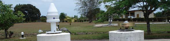
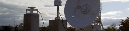
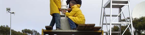

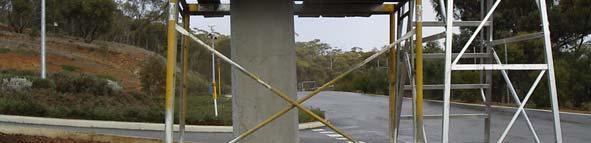
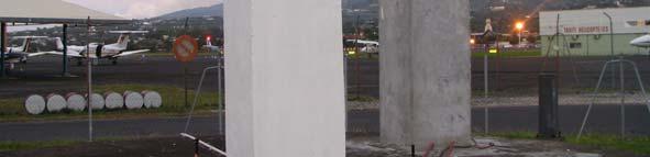
8 Galileo Experimental Sensor Stations Ground network for GIOVE satellites EUREF, Brussels 8
9 RINEX st version Nov 2007 (W. Gurtner / L. Estey) The upcoming European Navigation Satellite System Galileo and the enhanced GPS with new frequencies es and observation o types, especially the possibility to track frequencies on different channels, ask for a more flexible and more detailed definition of the observation codes. Better differentiation between the systems 3 characters for each observation type Line length no longer limited to 80 char EUREF, Brussels 9
10 Maintenance of GTRF Continuous operation to start t in September 2008 Weekly solutions validated with IGS Finals Semi-annual releases Combination aligned to ITRF2005 EUREF, Brussels 10
11 Maintenance of GTRF EUREF, Brussels 11
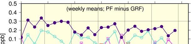
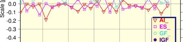
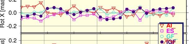
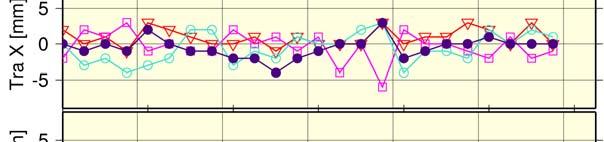
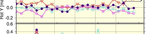
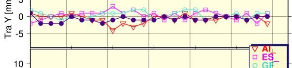
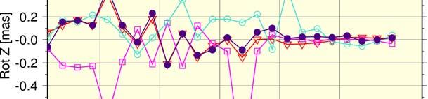
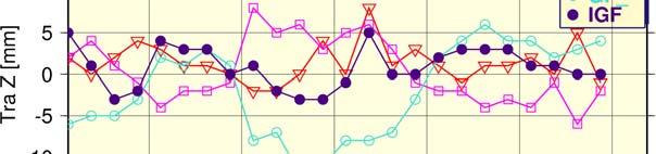
12 Results: internal precision Repeatability w.r.t. the cumulative solution (Z. Altamimi, 2008) EUREF, Brussels 12
13 Results: GESS & IGS residuals Torino, Italy (Z. Altamimi, 2008) EUREF, Brussels 13
14 Results: GESS & IGS residuals Kiruna, Sweden (Z. Altamimi, 2008) EUREF, Brussels 14
15 Results: GESS & IGS residuals Nordwijk, The Netherlands (ESTEC test site) Without discontinuity Discontinuity introduced (Z. Altamimi, 2008) EUREF, Brussels 15
16 Results: transformation parameters (Z. Altamimi, 2008) EUREF, Brussels 16
17 Results: Orbits & clocks (G. Gendt, 2008) EUREF, Brussels 17
18 Results: transformation parameters (G. Gendt, 2008) EUREF, Brussels 18
19 Results: ERP (G. Gendt, 2008) EUREF, Brussels 19
20 Recommendations for the transition phase I.e. phase between the end of GGSP prototype t and IOV Continuation of GESS monitoring Continuation of estimating versioned GTRF realization Starting of permanent processing in September 2008 until IOV Simulations concerning number and distribution of GSS Gradually substitution of IGS sites by GSS EUREF, Brussels 20
21 Recommendations for the operational service Upgrade of existing IGS+EPN stations ti to GPS + GLONASS + Galileo stations Inclusion of GSS into the IGS+EPN Extension of IGS+EPN products for Galileo Preparing standards, data bases etc. for Galileo Development of user-specific products to increase the acceptance of the GRSP EUREF, Brussels 21


22 GGSP/GRSP and EUREF Selection criteria of IGS/EPN stations Co-location with VLBI/SLR High-quality time reference Proposed Galileo site 21 EPN/IGS sites in GTRF 6 GPS+GLONASS 7ECGN Encourage GRSP to announce the GSS as EPN stations EUREF, Brussels 22
23 Thank you for your attention! EUREF, Brussels 23
EUREF 2014 Resolutions. Z. Altamimi, C. Bruyninx, R. Dach, M. Lidberg, M. Poutanen, W. Sohne, J. Torres, M. Greaves
 EUREF 2014 Resolutions Z. Altamimi, C. Bruyninx, R. Dach, M. Lidberg, M. Poutanen, W. Sohne, J. Torres, M. Greaves Resolution 1 considering the United Nations Committee of Experts on Global Geospatial
IGS Reprocessing. and First Quality Assessment
 IGS Reprocessing Summary of Orbit/Clock Combination and First Quality Assessment Gerd Gendt, GeoForschungsZentrum Potsdam Jake Griffiths, NOAA/National Geodetic Survey Thomas Nischan, GeoForschungsZentrum
Galileo Precise Orbit Determination at ESOC
 Navigation Support Office Galileo Precise Orbit Determination at ESOC Prof. Dr.-Ing. Werner Enderle Dr.-Ing. Erik Schoenemann Dr. Tim Springer Dr. Florian Dilssner Dr. Francesco Gini Dr. Claudia Flohrer
The International Terrestrial Reference System and ETRS89: Part II : ITRS & ETRS89 relationship
 The International Terrestrial Reference System and ETRS89: Part II : ITRS & ETRS89 relationship Zuheir ALTAMIMI Laboratoire de Recherche en Géodésie Institut national de l information géographique et forestière
UN-GGIM: Europe GRF-Europe. Markku Poutanen
 UN-GGIM: Europe GRF-Europe Markku Poutanen Global Geodetic Reference Frame GGRF The UN Committee of Experts on Global Geospatial Information Management (UN-GGIM) decided in July 2013 to formulate and facilitate
IGS-related multi-gnss activities at CODE
 IGS-related multi-gnss activities at CODE Lars Prange (1), Rolf Dach (1) Simon Lutz (1), Stefan Schaer (2), Adrian Jäggi (1) (1) Astronomical Institute, University of Bern, Switzerland source: http://boris.unibe.ch/57698/
UN Resolution on GGRF ( and its implementation in Europe)
") Presented at the FIG Working Week 2017, UN Resolution on GGRF ( and its implementation in Europe) May 29 - June 2, 2017 in Helsinki, Finland Markku Poutanen, FGI Contents Global Geodetic Reference Frame
Presented at the FIG Working Week 2017, UN Resolution on GGRF ( and its implementation in Europe) May 29 - June 2, 2017 in Helsinki, Finland Markku Poutanen, FGI Contents Global Geodetic Reference Frame
EUREF Technical Note 1: Relationship and Transformation between the International and the European Terrestrial Reference Systems
 EUREF Technical Note 1: Relationship and Transformation between the International and the European Terrestrial Reference Systems Zuheir Altamimi Institut National de l Information Géographique et Forestière
Galileo IOV Results. Navigation solutions powered by Europe
 Galileo IOV Results Navigation solutions powered by Europe Galileo IOV results 1. Galileo IOV System Configuration and IOV Test Campaign Objectives - E. Breeuwer (ESA) 2. Quality of the broadcast Galileo
Publ. Astron. Obs. Belgrade No. 91 (2012), REALIZATION OF ETRF2000 AS A NEW TERRESTRIAL REFERENCE FRAME IN REPUBLIC OF SERBIA
, REALIZATION OF ETRF2000 AS A NEW TERRESTRIAL REFERENCE FRAME IN REPUBLIC OF SERBIA") Publ. Astron. Obs. Belgrade No. 91 (2012), 199-206 Contributed paper REALIZATION OF ETRF2000 AS A NEW TERRESTRIAL REFERENCE FRAME IN REPUBLIC OF SERBIA D. BLAGOJEVIĆ and V. VASILIĆ Faculty of Civil Engineering,
Publ. Astron. Obs. Belgrade No. 91 (2012), 199-206 Contributed paper REALIZATION OF ETRF2000 AS A NEW TERRESTRIAL REFERENCE FRAME IN REPUBLIC OF SERBIA D. BLAGOJEVIĆ and V. VASILIĆ Faculty of Civil Engineering,
Developments towards GNSS real-time service in GFZ
 1 Developments towards GNSS real-time service in GFZ Dousa, J., Ge, M., Chen J., Gendt, G. Helmholtz-Zentrum Potsdam, Deutsches GeoForschungsZentrum Geng, J. University Institute of Engineering Surveying
IGS10, Newcastle upon Tyne England, 28 June 2 July, 2010 Combination of the reprocessed IGS Analysis Center SINEX solutions
 Combination of the reprocessed IGS Analysis Center SINEX solutions Rémi Ferland Geodetic Survey Division Contents Introduction Contribution Combined Products: Coordinates ERP s Apparent Geocenter Summary
Update on the In-orbit Performances of GIOVE Clocks
 Update on the In-orbit Performances of GIOVE Clocks Pierre Waller, Francisco Gonzalez, Stefano Binda, ESA/ESTEC Ilaria Sesia, Patrizia Tavella, INRiM Irene Hidalgo, Guillermo Tobias, GMV Abstract The Galileo
Status. EUREF TWG Meeting November 8 9, 2004, Praha
 ECGN was initiated by IAG Sub-Commission for Europe EUREF (SC1.3a) and IAG Sub-Commission for Europe of the International Gravity and Geoid Commission (IGGC) with relationship to Joint Research Centre
GEODETIC NETWORK OF SAUDI ARABIA AND FIDUCIAL STATIONS. GFN OF Saudi Arabia in Based on ITRF2000 Datum
 STUDIES OF TECTONIC MOVEMENTS IN SAUDI ARABIA USING CORS M. Al Rajhi, Ali Al Omar, R. Yanar, F. Kartal, K. Eren, SUBJECT TO TALKS BACKGROUND GEODETIC NETWORK OF SAUDI ARABIA AND FIDUCIAL STATIONS GFN OF
National Report of Sweden to the EUREF 2004 Symposium
 1 National Report of Sweden to the EUREF 2004 Symposium - geodetic activities at Lantmäteriet, the National Land Survey of Sweden Edited by Dan Norin Lantmäteriet, SE-801 82 Gävle, Sweden, dan.norin@lm.se
Report for 15th PCGIAP Meeting at 18th UNRCC-AP Working Group 1 Regional Geodesy
 Report for 15th PCGIAP Meeting at 18th UNRCC-AP Working Group 1 Regional Geodesy Chairman Shigeru Matsuzaka, Japan - shigeru@gsi.go.jp Vice Chairman Prof. Pengfei Cheng, China - chengpf@casm.ac.cn John
ESA/ESOC Status. T. Springer, E. Schoenmann, W. Enderle. ESA/ESOC Navigation Support Office. ESA UNCLASSIFIED - For Official Use
 ESA/ESOC Status T. Springer, E. Schoenmann, W. Enderle ESA/ESOC Navigation Support Office ESA UNCLASSIFIED - For Official Use Content Issues in BIAS PP Status regarding future ILRS plans Other ILRS/SLR
CODE's multi-gnss orbit and clock solution
 source: https://doi.org/10.7892/boris.68193 downloaded: 13.3.2017 CODE's multi-gnss orbit and clock solution L. Prange, E. Orliac, R. Dach, D. Arnold, G. Beutler, S. Schaer, A. Jäggi Astronomical Institute,
Impact of the SRP model on CODE's 5- system orbit and clock solution for the MGEX
 Impact of the SRP model on CODE's 5- system orbit and clock solution for the MGEX L. Prange, E. Orliac, R. Dach, D. Arnold, G. Beutler, S. Schaer, A. Jäggi Astronomical Institute, University of Bern, Switzerland
Title: Impact of Regional Reference Frame Definition on Geodynamic Interpretations
 Author manuscript, published in "Journal of Geodynamics 49, 3-4 (2010) 116" DOI : 10.1016/j.jog.2009.10.002 Title: Impact of Regional Reference Frame Definition on Geodynamic Interpretations Authors: J.
THREE SEASONAL BEHAVIOUR OF THE BALKAN PENINSULA GNSS PERMANENT STATIONS FROM GPS SOLUTIONS
 Доклади на Българската академия на науките Comptes rendus de l Académie bulgare des Sciences Tome 66, No 1, 2013 GEOPHYSIQUE Sismologie THREE SEASONAL BEHAVIOUR OF THE BALKAN PENINSULA GNSS PERMANENT STATIONS
Dealing with significant differential tectonic plate velocities within an RTK-network: The case of HEPOS
 Dealing with significant differential tectonic plate velocities within an RTK-network: The case of HEPOS M. Gianniou, E. Mitropoulou, I. Stavropoulou National Cadastre and Mapping Agency S.A. Mesogion
Latest improvements in CODE's IGS MGEX solution
 Latest improvements in CODE's IGS MGEX solution L. Prange, R. Dach, G. Beutler, D. Sidorov, A. Villiger, S. Schaer, A. Jäggi Astronomical Institute, University of Bern, Switzerland Federal office of topography
COST Action ES1206 Advanced Global Navigation Satellite Systems tropospheric products for monitoring severe weather events and climate (GNSS4SWEC)
") COST Action ES1206 Advanced Global Navigation Satellite Systems tropospheric products for monitoring severe weather events and climate (GNSS4SWEC) R. Pacione, J. Jones, G. Guerova, J. Dousa, G. Dick, S.
COST Action ES1206 Advanced Global Navigation Satellite Systems tropospheric products for monitoring severe weather events and climate (GNSS4SWEC) R. Pacione, J. Jones, G. Guerova, J. Dousa, G. Dick, S.
Evaluation on the Multi-GNSS Precise Orbit and Clock Products
 Evaluation on the Multi-GNSS Precise Orbit and Clock Products Fei Guo 1, 2, Xingxing Li 3, Xiaohong Zhang 1, Jinling Wang 2 1 School of Geodesy and Geomatics, Wuhan University, China 2 School of Civil
Status Report on the Working Group on "European Dense Velocities" Simon Lutz, Elmar Brockmann and members of the EUREF Working Group
 Status Report on the Working Group on "European Dense Velocities" Simon Lutz, Elmar Brockmann and members of the EUREF Working Group Outline Introduction Contributing solutions First results from the combination
Consideration of a Global Vertical Reference System (GVRS) in the IERS Conventions
 in the IERS Conventions") Consideration of a Global Vertical Reference System (GVRS) in the IERS Conventions Johannes Ihde Federal Agency for Cartography and Geodesy (BKG) Chair of IAG ICP1.2 (2003-2007) Vertical Reference Frames
Consideration of a Global Vertical Reference System (GVRS) in the IERS Conventions Johannes Ihde Federal Agency for Cartography and Geodesy (BKG) Chair of IAG ICP1.2 (2003-2007) Vertical Reference Frames
ESTIMATION AND PREDICTION OF THE GIOVE CLOCKS
 ESTIMATION AND PREDICTION OF THE GIOVE CLOCKS Irene Hidalgo GMV, Madrid, Spain E-mail: ihidalgo@gmv.com R. Píriz, A. Mozo, G. Tobias, P. Tavella *, I. Sesia *, G. Cerretto *, P. Waller +, F. González +,
Brussels, BELGIUM. Bojan Stopar. Faculty of Civil and Geodetic Engineering
 EUREF 2008 Symposium Brussels, BELGIUM June 18-20, 2008 NATIONAL REPORT OF SLOVENIA Bojan Stopar University of Ljubljana University of Ljubljana Faculty of Civil and Geodetic Engineering ADOPTION OF THE
Fundamental Station Wettzell - geodetic observatory -
 Fundamental Station Wettzell - geodetic observatory - Wolfgang Schlüter Bundesamt für Kartographie und Geodäsie, Fundamental Station Wettzell Germany Radiometer Workshop, Wettzell, 10.10.06 Evolvement
Local Ties Between the Reference Points at the. with the Transportable Integrated Geodetic Observatory (TIGO) in Concepcion/Chile
 in Concepcion/Chile") Local Ties Between the Reference Points at the Transportable Integrated Geodetic Observatory (TIGO) in Concepcion/Chile Wolfgang Schlüter 1, Hayo Hase 3, Rudolf Zernecke 2, Swetlana Becker 2, Thomas Klügel
Local Ties Between the Reference Points at the Transportable Integrated Geodetic Observatory (TIGO) in Concepcion/Chile Wolfgang Schlüter 1, Hayo Hase 3, Rudolf Zernecke 2, Swetlana Becker 2, Thomas Klügel
Earth gravity field recovery using GPS, GLONASS, and SLR satellites
 13-01-08 Earth gravity field recovery using GPS, GLONASS, and SLR satellites Krzysztof Sośnica (1), Adrian Jäggi (1), Daniela Thaller (2), Ulrich Meyer (1), Christian Baumann (1), Rolf Dach (1), Gerhard
EPOS-RT: Software for Real-time GNSS Data Processing
 EGU 2009,Session G4,21 April,2009 1 EPOS-RT: Software for Real-time GNSS Data Processing Maorong Ge, Junping Chen, Gerd Gendt Department of Geodesy and Remote Sensing, Deutsches GeoForschungsZentrum Contact:
Co-location of VLBI with other techniques in space: a simulation study
 Co-location of VLBI with other techniques in space: a simulation study B. Männel, M. Rothacher ETH Zürich, Geodesy and Geodynamics Lab 7 th IGS General Meeting, Madrid 212 1 Reference frame and local ties
GGOS, ECGN and NGOS: Global and regional geodetic observing systems. Markku Poutanen Finish Geodetic Institute
 GGOS, ECGN and NGOS: Global and regional geodetic observing systems Markku Poutanen Finish Geodetic Institute Contents GGOS, ECGN, NGOS Why? How? Future? (geodesy) GGOS Structure GGOS Structure European
INTERNATIONAL SLR SERVICE
 ARTIFICIAL SATELLITES, Vol. 46, No. 4 2011 DOI: 10.2478/v10018-012-0004-z INTERNATIONAL SLR SERVICE Stanisław Schillak Space Research Centre, Polish Academy of Sciences Astrogeodynamic Observatory, Borowiec
Densification of the GGOS infrastructure in Poland in the framework of EPOS-PL
 EPOS European Plate Observing System Densification of the GGOS infrastructure in Poland in the framework of EPOS-PL K. Sośnica 1, J. Bosy 1, J. Kapłon 1, W. Rohm 1, T. Hadaś 1, J. Sierny 1, I. Kudłacik
Challenges and Perspectives for TRF and CRF Determination
 , IVS 2012 General Meeting Proceedings, p.309 313 http://ivscc.gsfc.nasa.gov/publications/gm2012/boehm.pdf Johannes Böhm 1, Zinovy Malkin 2, Sebastien Lambert 3, Chopo Ma 4 1) Vienna University of Technology
the experience of INRIM in the Galileo project
 FIFTH MEETING OF THE INTERNATIONAL COMMITTEE ON GLOBAL NAVIGATION SATELLITE SYSTEMS (ICG) Time metrology in navigation systems: the experience of INRIM in the Galileo project Patrizia i Tavella Istituto
CEGRN Consortium. A first campaign took place in Since 1997, each two years, a weekly campaign has been observed, normally in June.
 CEGRN 2015 Campaign A. Caporali (1), J. Zurutuza (1), O. Khoda (2), G. Stangl (3), M. Becker (4), M. Bertocco (1), L. Gerhatova (5), M. Mojzes (5), M. Mulic (6), Yu. Stopkhay (7), C. Nagorneac (8), A.
PRECISE ORBIT DETERMINATION OF GPS SATELLITES FOR REAL TIME APPLICATIONS
 J. Astron. Space Sci. 18(2), 129 136 (2001) GPS,,,, PRECISE ORBIT DETERMINATION OF GPS SATELLITES FOR REAL TIME APPLICATIONS Hyung-Chul Lim, Pil-Ho Park, Jong-Uk Park, Jung-Ho Cho, Yong-Won Ahn GPS Research
Strategy for the Realization of the International Height Reference System (IHRS)
") Deutsches Geodätisches Forschungsinstitut (DGFI-TUM) Technische Universität München Strategy for the Realization of the International Height Reference System (IHRS) Laura Sánchez 1, Johannes Ihde 2, Roland
Deutsches Geodätisches Forschungsinstitut (DGFI-TUM) Technische Universität München Strategy for the Realization of the International Height Reference System (IHRS) Laura Sánchez 1, Johannes Ihde 2, Roland
The Victorian Seismic Zone 2011 GNSS Campaign Data Analysis
 G E O S C I E N C E A U S T R A L I A The Victorian Seismic Zone 2011 GNSS Campaign Data Analysis G. Hu Record 2012/38 GeoCat # 74005 APPLYING GEOSCIENCE TO AUSTRALIA S MOST IMPORTANT CHALLENGES The Victorian
Development of Algorithms for use in the Galileo Time Service Provider
 Development of Algorithms for use in the Galileo Time Service Provider D Baines 1, J A Davis 1, G Parkin 1, P Harris 1, A Batchelor 2, J. M. Pieplu 3, J. H. Hahn 4, A Bauch 5, V. Pettiti 6, P. Uhrich 7,
Week 02. Assist. Prof. Dr. Himmet KARAMAN
 Week 02 Assist. Prof. Dr. Himmet KARAMAN Contents Satellite Orbits Ephemerides GPS Review Accuracy & Usage Limitation Reference Systems GPS Services GPS Segments Satellite Positioning 2 Satellite Orbits
REGIONAL REFERENCE FRAMES: THE IAG PERSPECTIVE
 REGIONAL REFERENCE FRAMES: THE IAG PERSPECTIVE João Agria Torres SPUIAGG IAG Sub-commission 1.3: Regional Reference Frames jatorres@iol.pt 1. About the IAG CONTENT 2. Objectives and organization of SC
Global Terrestrial Reference Systems and Frames: Application to the International Terrestrial Reference System/Frame
 Global Terrestrial Reference Systems and Frames: Application to the International Terrestrial Reference System/Frame Zuheir ALTAMIMI Laboratoire de Recherche en Géodésie Institut National de l Information
NATIONAL REPORT OF POLAND TO EUREF 2011
 NATIONAL REPORT OF POLAND TO EUREF 2011 Jan Krynski Institute of Geodesy and Cartography, Warsaw Jerzy B. Rogowski Warsaw University of Technology, Warsaw Outline Main geodetic activities at the national
Memo : Specifications for reference frame fixing in the analysis of a EUREF GPS campaign
 ' ' 7 7 7 6 6 ' Memo : Specifications for reference frame fixing in the analysis of a EUREF GPS campaign Version 1 : 30-09-1993 Version 2 : 07-03-1995 Version 3 : 10-02-1997 Version 4 : 0-01-199 Version
This presentation covers the following areas
 Geodetic Datums and Coordinate Systems for Surveying and Mapping in Hong Kong FIG Working Week 2012 Rome, Italy 6-10 May Simon KWOK Hong Kong, China 1 This presentation covers the following areas Explains
A Strategic Plan for Geodesy in Sweden. Mikael Lilje Lars E. Engberg Geodesy Department Lantmäteriet Sweden
 A Strategic Plan for Geodesy in Sweden Mikael Lilje Lars E. Engberg Geodesy Department Lantmäteriet Sweden Our vision is to be able to meet Swedish society s needs for a homogeneous, sustainable geodetic
A New Transformation Including Deformation Model for the Nordic and Baltic Countries
 A New Transformation Including Deformation Model for the Nordic and Baltic Countries Pasi HÄKLI, Finland, Martin LIDBERG, Sweden, Lotti JIVALL, Sweden, Torbjørn NØRBECH, Norway, Oddvar TANGEN, Norway,
MEMORANDUM OF UNDERSTANDING
 MEMORANDUM OF UNDERSTANDING between A: EUREF, the Reference Frame Sub-Commission for Europe of the International Association of Geodesy (IAG) and B: EUMETNET, the Network of European Meteorological Services.
ECGN - Development of the European Combined Geodetic Network in Austria
 ECGN - Development of the European Combined Geodetic Network in Austria Diethard Ruess 1, Gelöscht: BEV Dept. Control Survey Abstract Austria takes part in the European Combined Geodetic Network - Project
EUROPEAN GNSS (GALILEO) INITIAL SERVICES NAVIGATION SOLUTIONS POWERED BY E U R O P E OPEN SERVICE QUARTERLY PERFORMANCE REPORT
 INITIAL SERVICES NAVIGATION SOLUTIONS POWERED BY E U R O P E OPEN SERVICE QUARTERLY PERFORMANCE REPORT") NAVIGATION SOLUTIONS POWERED BY E U R O P E EUROPEAN GNSS (GALILEO) INITIAL SERVICES OPEN SERVICE QUARTERLY PERFORMANCE REPORT OCTOBER - DECEMBER 2017 TABLE OF CONTENTS 1 INTRODUCTION... 1 2 EXECUTIVE
NAVIGATION SOLUTIONS POWERED BY E U R O P E EUROPEAN GNSS (GALILEO) INITIAL SERVICES OPEN SERVICE QUARTERLY PERFORMANCE REPORT OCTOBER - DECEMBER 2017 TABLE OF CONTENTS 1 INTRODUCTION... 1 2 EXECUTIVE
National Report of Greece to EUREF 2016
 National Report of Greece to EUREF 2016 M.Gianniou, E. Mitropoulou, D. Mastoris National Cadastre and Mapping Agency S.A. Mesogion Ave. 288, 15562 Athens, Greece 1. Introduction During the last months
Assessment of the orbits from the 1st IGS reprocessing campaign
 Assessment of the orbits from the 1st IGS reprocessing campaign results from combined reprocessed IGS GPS orbits and EOPs assessment of IG1 orbit repeatability items to consider for next reprocessing Jake
Reference Systems Realization for the Territory of Bulgaria - Status and Perspectives
 Conference and plenary meeting of the Permanent Committee on Cadastre in the European Union 13-15 March 2018, Sofia Reference Systems Realization for the Territory of Bulgaria - Status and Perspectives
Operational Support by ESOC s GRAS Ground Support Network - Status and Outlook
 ESA UNCLASSIFIED Releasable to the public Operational Support by ESOC s GRAS Ground Support Network - Status and Outlook R. Zandbergen, F.Wollenweber, C.Marquardt, W. Enderle and the ESOC and EUMETSAT
Role and importance of the International Terrestrial Reference Frame for sustainable development
 Role and importance of the International Terrestrial Reference Frame for sustainable development This report is provided for the benefit of participants of the UNRCC-PCGIAP Informal Geodetic Consultation,
GGOS Bureau for Standards and Conventions
 GGOS D. Angermann (1), T. Gruber (2), J. Bouman (1), M. Gerstl (1), R. Heinkelmann (1), U. Hugentobler (2), L. Sánchez (1), P. Steigenberger (2) (1) Deutsches Geodätisches Forschungsinstitut (DGFI), München
The APREF Project: First Results and Analysis
 The APREF Project: First Results and Analysis Lennard Huisman 1*, John Dawson 2, and Peter J G Teunissen 1 1 GNSS Research, Curtin University of Technology, Australia, l.huisman@curtin.edu.au 2 Earth Monitoring
On the use of meteo data. How to raise the value of EPN s
 On the use of meteo data or How to raise the value of EPN s ZTD product? Jan Dousa & Wolfgang Söhne 50th EUREF TWG, Florence, 2009-05-26 Introduction Last TWG (Jan Dousa's presentation): ti Towards more
A new transformation including deformation model for the Nordic. and Baltic countries
 A new transformation including deformation model for the Nordic Presented at the FIG Working Week 2017, May 29 - June 2, 2017 in Helsinki, Finland and Baltic countries P. Häkli, M. Lidberg, L. Jivall,
New satellite mission for improving the Terrestrial Reference Frame: means and impacts
 Fourth Swarm science meeting and geodetic missions workshop ESA, 20-24 March 2017, Banff, Alberta, Canada New satellite mission for improving the Terrestrial Reference Frame: means and impacts Richard
Towards a Rigorous Combination of Space Geodetic Techniques
 Towards a Rigorous Combination of Space Geodetic Techniques Markus Rothacher Forschungseinrichtung Satellitengeodäsie, TU Munich, Germany Abstract: The with all its different components and products, ranging
Working Group 1. Geodetic Reference Frame. Activity Report. for. The UN-GGIM-AP Plenary Meeting
 Regional Committee of United Nations Global Geospatial Information Management for Asia and the Pacific (UN-GGIM-AP) Established by a United Nations Resolution Working Group 1 Geodetic Reference Frame Activity
Influence of the Reference Frame Alignment on Station Positions and Velocities: Global or Regional?
 AGU Fall Meeting, San Francisco, USA, 15 19 December 2008 Influence of the Reference Frame Alignment on Station Positions and Velocities: Global or Regional? J. Legrand(1), N. Bergeot(1), C. Bruyninx(1),
RINEX Extensions to Handle Clock Information ********************************************
 RINEX Extensions to Handle Clock Information ******************************************** Jim Ray, US Naval Observatory Werner Gurtner, University of Berne (Initial version, 27 August 1998) (Error in example
SECOND ANNOUNCEMENT International Technical Laser Workshop 2012 (ITLW-12)
") SECOND ANNOUNCEMENT International Technical Laser Workshop 2012 (ITLW-12) Version 31/Oct/12 Satellite, Lunar and Planetary Laser Ranging: characterizing the space segment Frascati National Laboratories
SECOND ANNOUNCEMENT International Technical Laser Workshop 2012 (ITLW-12) Version 31/Oct/12 Satellite, Lunar and Planetary Laser Ranging: characterizing the space segment Frascati National Laboratories
National report of Slovakia 2017
 National report of Slovakia 2017 Branislav Droščák, Karol Smolík, Pavol Ceizel, Ján Bublavý, Miroslav Steinhubel, et al. 1) Juraj Papčo, Ľubomíra Gerhátová, Marcel Mojzeš, Martin Imrišek, et al. 2) Katarína
The APREF Project. The Asia-Pacific regional geodetic
 The GEODESY APREF Project The Asia-Pacifi c Reference Frame (APREF) is an initiative that recognizes the importance of improving the regional geodetic framework in the Asia-Pacifi c region Lennard Huisman
Data base of Italian velocities and strain rates at permanent GNSS sites. A. Caporali, M. Bertocco, J. Zurutuza, University of Padova
 Data base of Italian velocities and strain rates at permanent GNSS sites A. Caporali, M. Bertocco, J. Zurutuza, University of Padova Outlook Part 1: GNSS data reduction and organization Italian permanent
COST-716, EUMETNET and possible role of EUREF
 EUREF TWG Meeting, Budapest, Hungary, March 22-23, 2004 COST-716, EUMETNET and possible role of EUREF Hans VAN DER MAREL, Elmar BROCKMANN Delft University of Technology, Aerospace Engineering (DEOS/MGP)
Geodesy Part of the ACES Mission: GALILEO on Board the International Space Station
 Geodesy Part of the ACES Mission: GALILEO on Board the International Space Station 1 Svehla D, 2 Rothacher M, 3 Salomon C, 2 Wickert J, 2 Helm A, 2 Beyerle, G, 4 Ziebart M, 5 Dow J 1 Institute of Astronomical
Evaluation of the impact of atmospheric pressure loading modeling on GNSS data analysis
 Evaluation of the impact of atmospheric pressure loading modeling on GNSS data analysis R. Dach a, J. Böhm b, S. Lutz a, and P. Steigenberger c a Astronomical Institute, University of Bern, Bern, Switzerland
A priori gradients in the analysis of GPS and VLBI observations
 A priori gradients in the analysis of GPS and VLBI observations Peter Steigenberger GeoForschungsZentrum Potsdam Volker Tesmer Deutsche Geodätisches Forschungsinstitut, München Johannes Boehm Institute
Improved GNSS-Based Precise Orbit Determination by using highly accurate clocks
 Improved GNSS-Based Precise Orbit Determination by using highly accurate clocks A. Susnik 1, R. Dach 1, K. Wang 2, M. Meindl 2, M. Rothacher 2, D. Koch 2, T. Romanyuk 3, I. Selmke 3, U. Hugentobler 3,
Tide Gauge Benchmark Monitoring Need for Reprocessing in Europe. Tilo Schöne & the IGS TIGA Working Group
 Tide Gauge Benchmark Monitoring Need for Reprocessing in Europe Tilo Schöne & the IGS TIGA Working Group Vertical Tide Gauge Control Long-term stable and consistent frame to relate globally distributed
IN-ORBIT PERFORMANCE ASSESSMENT OF GIOVE CLOCKS
 IN-ORBIT PERFORMANCE ASSESSMENT OF GIOVE CLOCKS Pierre Waller European Space Agency ESTEC E-mail: pierre.waller@esa.int F. Gonzalez, J. Hahn, S. Binda, ESA-ESTEC, Noordwijk, The Netherlands R. Piriz, I.
Definition and Realization of the EVRS: How do we want to proceed?
 Definition and Realization of the EVRS: How do we want to proceed? Gunter Liebsch, Axel Rülke, Martina Sacher, Johannes Ihde EUREF Symposium 2014 June 04-06, 2014, Vilnius, Lithuania Content Introduction,
Exploitation of ground based GPS for Climate and Numerical Weather Prediction applications COST action 716
 Exploitation of ground based GPS for Climate and Numerical Weather Prediction applications COST action 716 COST Objectives and status of COST 716 Overview of work packages / projects Near real-time demonstration
SIRGAS: Basis for Geosciences, Geodata, and Navigation in Latin America
 SIRGAS: Basis for Geosciences, Geodata, and Navigation in Latin America Claudio Brunini President of SIRGAS Universidad Nacional de La Plata, Argentina María Virginia Mackern President of SIRGAS/WG-I:
Current status of the ITRS realization
 Current status of the ITRS realization Input data Principles for datum definition Combination strategies (3 CCs) Some notes on ITRF2005 Next ITRF solution (?) Zuheir Altamimi ITRS PC ITRF Input Data Up
Ionosphere Prediction Service for GNSS Users
 Ionosphere Prediction Service for GNSS Users International Technical Symposium on Navigation and Timing Filippo Rodriguez, PhD, Telespazio 15th November 2018 Introduction Monitoring and forecasting of
Geodetic Department KTIMATOLOGIO S.A. (Hellenic Cadastre) K. Katsampalos, C. Kotsakis Department of Geodesy and Surveying
 K. Katsampalos, C. Kotsakis Department of Geodesy and Surveying") Realization of ETRS89 in Greece by the HEPOS network M. Gianniou i Geodetic Department KTIMATOLOGIO S.A. (Hellenic Cadastre) mgianniu@ktimatologio.gr K. Katsampalos, C. Kotsakis Department of Geodesy and
Realization of ETRS89 in Greece by the HEPOS network M. Gianniou i Geodetic Department KTIMATOLOGIO S.A. (Hellenic Cadastre) mgianniu@ktimatologio.gr K. Katsampalos, C. Kotsakis Department of Geodesy and
System of Geodetic Parameters Parametry Zemli 1990 PZ-90.11
 System of Geodetic Parameters Parametry Zemli 1990 PZ-90.11 Authors: PhD Anastasiya N. Zueva, PhD Evgeniy V. Novikov, Dr. Dmitriy I. Pleshakov, PhD Igor V. Gusev Speaker: Igor Gusev 9 th Mee'ng of the
Reference frames and positioning
 The APREF Project: an Improved Geodetic Infrastructure for Asia and the Pacific (4861) John Dawson (Australia), Graeme Blick (New Zealand), Manoj Deo, Guorong Hu and Gary Johnston (Australia) Reference
Impact of GPS box-wing models on LEO orbit determination
 Impact of GPS box-wing models on LEO orbit determination Heike Peter (1), Tim Springer (1),(2), Michiel Otten (1),(2) (1) PosiTim UG Sentinel-1 GPS-IIF (2) ESA/ESOC Sentinel-2 Credits:ESA gps.gov IGS Workshop
GRUAN GNSS Precipitable Water (GNSS-PW) Task Team: Accomplishment, Progress and Plan
 Task Team: Accomplishment, Progress and Plan") GRUAN GNSS Precipitable Water (GNSS-PW) Task Team: Accomplishment, Progress and Plan Co-chairs: Junhong (June) Wang and Kalev Rannat Members: John Braun, UCAR, USA Galina Dick, GeoForschungsZentrum Potsdam,
GRUAN GNSS Precipitable Water (GNSS-PW) Task Team: Accomplishment, Progress and Plan Co-chairs: Junhong (June) Wang and Kalev Rannat Members: John Braun, UCAR, USA Galina Dick, GeoForschungsZentrum Potsdam,
TOWARDS ROBUST LOCALIZATION OF RTK-GPS TOPOGRAPHIC SURVEYS 23
 TOWARDS ROBUST LOCALIZATION OF RTK-GPS TOPOGRAPHIC SURVEYS Jerry W. Nave, North Carolina A&T University; Tarig A. Ali, American University of Sharjah Abstract Localization is performed to fit the observed
The Interactions between IGS and GGOS
 The Interactions between IGS and GGOS Markus Rothacher Institute of Geodesy and Photogrammetry (IGP) ETH Zurich, Switzerland 2012 IGS Workshop July 23-27, 2012, Olsztyn, Poland Overview GGOS Vision, Mission
GNSS space clocks assessment based on different IGS and MGEX data. Tung Thanh Thai, Giovanna Signorile, Ilaria Sesia
 GNSS space clocks assessment based on different IGS and MGEX data Tung Thanh Thai, Giovanna Signorile, Ilaria Sesia 1 INRIM and GNSS Time Metrology INRIM is involved in characterization of atomic clocks
Preparation for the ITRF2013. Zuheir Altamimi Xavier Collilieux Laurent Métivier IGN, France
 Preparation for the ITRF2013 Zuheir Altamimi Xavier Collilieux Laurent Métivier IGN, France 1 Outline Introduction Solicited solutions Analysis Strategy Preparation for the ITRF2013: Combination tests
GRUAN Station Report for Ny-Ålesund
 WMO/IOC/UNEP/ICSU GLOBAL CLIMATE OBSERVING SYSTEM (GCOS) 8th GRUAN Implementation- Coordination Meeting (ICM-8) Boulder, USA 25 April 29 April 2016 Doc. 7.11 (05.IV.2016) Session 7 GRUAN Station Report
Modernization of National Geodetic Datum in China *
 UNITED NATIONS E/CONF.102/IP.16 ECONOMIC AND SOCIAL COUNCIL Nineteenth United Nations Regional Cartographic Conference for Asia and the Pacific Bangkok, 29 October 1 November 2012 Item 6(b) of the provisional
Update on the International Terrestrial Reference Frame (ITRF) : ITRF2014. Zuheir Altamimi
 : ITRF2014. Zuheir Altamimi") Update on the International Terrestrial Reference Frame (ITRF) : ITRF2014 Zuheir Altamimi Head of the IERS ITRF Product Center IAG Vice President IGN, France E-mail: zuheir.altamimi@ign.fr Key Points Introduction:
Update on the International Terrestrial Reference Frame (ITRF) : ITRF2014 Zuheir Altamimi Head of the IERS ITRF Product Center IAG Vice President IGN, France E-mail: zuheir.altamimi@ign.fr Key Points Introduction:
Ground-based GPS networks for remote sensing of the atmospheric water vapour content: a review
 Ground-based GPS networks for remote sensing of the atmospheric water vapour content: a review Gunnar Elgered Earth and Space Sciences, Chalmers University of Technology, Onsala Space Observatory, SE-43992
Multi-GNSS Working Group Technical Report 2016
 Multi-GNSS Working Group Technical Report 2016 P. Steigenberger 1, O. Montenbruck 1 1 Deutsches Zentrum für Luft- und Raumfahrt (DLR) German Space Operations Center (GSOC) Münchener Straße 20 82234 Wessling,