Overview of geophysical methods used in geophysical exploration
|
|
|
- Melvin Holland
- 5 years ago
- Views:
Transcription


1 Overview of geophysical methods used in geophysical exploration Lúdvík S. Georgsson United Nations University Geothermal Training Programme Orkustofnun Reykjavík ICELAND

2 The role of the geophysicist
3 Measuring physical properties of earth Geophysical exploration of geothermal resources deals with measurements on the physical properties of the earth. Emphasis on parameters sensitive to temperature and fluid content of the rocks. Aim is to delineate a geothermal resources, outline a production field, locate aquifers and site wells or estimate properties of the system. Ultimately the information is used for economic exploitation of the resource.
4 Parameters Reservoir Temperature Porosity Permeability Chemical content of fluid (salinity) (Pressure) Measured Temperature ( C) Electrical resistivity (Ωm) Magnetisation (Vs/m 2 ) Density (kg/m 3 ) Seismic velocity (km/s) Seismic activity Thermal conductivity (W/mK) Streaming potential (V)
5 Methods Direct Thermal methods Electrical methods SP Structural / indirect Magnetics Gravity Seismic methods Seismicity
6 Approach Combine methods No method universally applicable Different for low-temperature and high-temperature Choose carefully Usually two or more give most reliable results Different approach in different countries Important to be ready to improvise or try new methods Integrated surveys Geophysical exploration does not stand alone, needs to be integrated with geology and geochemistry? Success of a survey Success is best measured by time, effort and money the survey has saved.
7 Direct measurements Thermal methods of temperature and heat. No methods correlate better with the properties of the geothermal system. Heat exchange Conduction - atomic vibrations, important for transfer of heat in the earth's crust. Convection - transfers heat with motion of mass, natural circulation of hot water. Radiation - not in geothermal
8 Thermal conduction Heat flow Convection The simplified geothermal relationship is (conductive heat transfer only): Q cond-z = - k T/ z where k is the thermal conductivity (W/m C) and T/ z the thermal gradient Anomalous values, above mw/m 2, may indicate geothermal conditions in the subsurface Thermal conductivity of rocks ranges between 1 and 5 W/m C Convection Free, driven by density gradients Forced, driven by an external pressure gradient, like hydrostatic head Geothermal systems are of mixed type
9 Application Thermal distribution at the surface Detailed mapping (GPS) Soil temperature measurement Airborne IR survey Temperature in m gradient wells Used to delineate regional or local gradient anomalies Heat flow surveys for regional assessment Thermal conductivity measurements, gradient survey with possible terrain corrections
10 Ásgardur thermal map

11 Hvalfjördur gradient map
12 Electrical methods Most important in geothermal exploration Electrical current is induced into the earth - signals that are generated are monitored at the surface - many varying methods DC methods, current injected into earth through electrodes at the surface - the signal measured is the electrical field generated at the surface. MT, current is induced by the time variations in earth's magnetic field - the signal measured is the electromagnetic field at the surface. TEM, current induced by a time varying magnetic field from a controlled source - the monitored signal is the decaying magnetic field at surface.
13 Ohm s law Resistivity Ē = j E is electrical field strength (V/m) j is current density (A/m 2 ) is electrical resistivity ( m) - material constant For a unit cube/bar, resistivity is defined as = V / I The reciprocal of resistivity is conductivity Most rocks are resistive, conduction is through water in pores and at water-rock contact.
14 Resistivity of water bearing rocks Controlled by: Porosity and pore structure Intergranular sediments Joints-fissures - tension, cooling - igneous rocks Vugular dissolved material, gas - volcanics, limestone Alteration (water-rock interaction) Salinity of the water Temperature Amount of water - saturation - steam content Pressure Electric conduction is mainly through interconnected water-filled pores.
15 Resistivity structure summarized Resistivity Structure summarised OO ALTERATION RESISTIVITY TEMPERATURE Saline water Fresh water C Boiling curve Pore fluid conduction C C Amb. temp Mineral conduction Rel. unaltered Smectite- zeolite zone Mixed layer clay zone Chlorite zone Chlorite-epidote zone


16 DC methods Sounding - Profiling Sounding - centre fixed, electrode spacing varied used for mapping resistivity changes with depth Profiling - electrode distances fixed, whole array moved in profile line - for mapping lateral changes Many methods - different electrode arrays Schlumberger sounding, widely used Dipole sounding or profiling, various arrays Wenner, not much used today Head-on profiling, for locating fractures

17 DC methods Schlumberger

18 Reykjahverfi Resistivity at 500 m b.s.l.

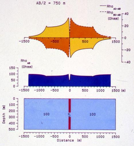
19 Öxarfjördur Schlumberger resistivity cross-section

20 Head-on profiling
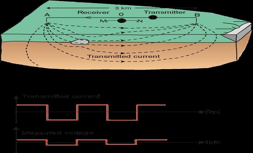
21 Electromagnetic methods Natural-source electromagnetics - MT, AMT Natural EM field used as an energy source. Low frequencies, Hz are used for deep crustal investigations, higher freq., Hz, for the upper crust. Contro.-source electromag. TEM, LOTEM, CSMT In TEM, constant magnetic field is built up by transmitting current I through a big loop (grounded dipole), and then I is abruptly turned off. A secondary field is induced, decaying with time. This decay rate is monitored by measuring the voltage induced in a receiver coil in the centre of the loop. Current distribution and decay rate recorded as a function of time depend on the resistivity structure.


22 TEM configuration Transmitted current Measured voltage

23 Hengill - TEM resistivity map at 600 m b.s.l.


24 Hengill TEM resistivity cross-section
25 Elevation (m) Menengai - MT cross-section Menengai Crater 2000 MT01 MT60 MT13 MT58 MT57 MT55 MT53 MT59 MT51 m Horizontal distance (m)


26 SP DC-component of earth s nat. electrical potentials Significant anomalies associated w. geothermal activity
27 Structural methods Magnetic methods are widely used in geothermal exploration often together with gravity and refraction in mapping geological structures - based on varying magnetisation in rocks Gravity surveys are used in geothermal exploration to detect geological formations with different densities, are as such a typical structural method Active seismic methods detect sound velocity distribution and anomalies in the earth and attenuation Passive seismic methods detect seismic activity in the earth
28 Two kinds of magnetisation Magnetic method Induced magnetisation Mi - same direction as the ambient earth's field; Permanent magnetisation Mp, in igneous rocks it often predominates; it depends upon their properties and history Magnetic anomaly is a local disturbance caused by local change in magnetisation; characterised by the direction and magnitude of the effective magnetisation and the shape, position, properties and history of the anomalous body Measurements aim mainly at finding location and depth estimate of hidden intrusives or tracing buried dykes and faults, or areas of reduced magnetization due to thermal activity Procedures - On ground, regular measurements in profiles or grid, In aeromagnetic surveys, e.g. 100 m a.g. and with 100 m between lines


29 Ásgardur Magnetic map

30 Ásgardur - 3D magnetic map
31 Gravity & density - Gravity measurements Gravity measurements are based on density contrasts of rocks in the earth which lead to different gravitational force usually measured in mgal or 10-3 m 2 /s Gravity usually shown as Bouguer anomaly (after corrections): g B = g M + C FA - C B + C T - g N Density depends on rock composition & porosity, ~2-3 g/cm 3 Important applications Basement depth variation (sedimentary area) Intrusive rocks (possible heat source) Fault or dyke systems etc. Alteration, cementation due to thermal effects Monitoring mass extraction with production

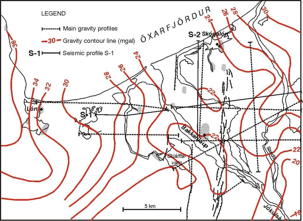
32 Öxarfjördur Bouguer gravity map
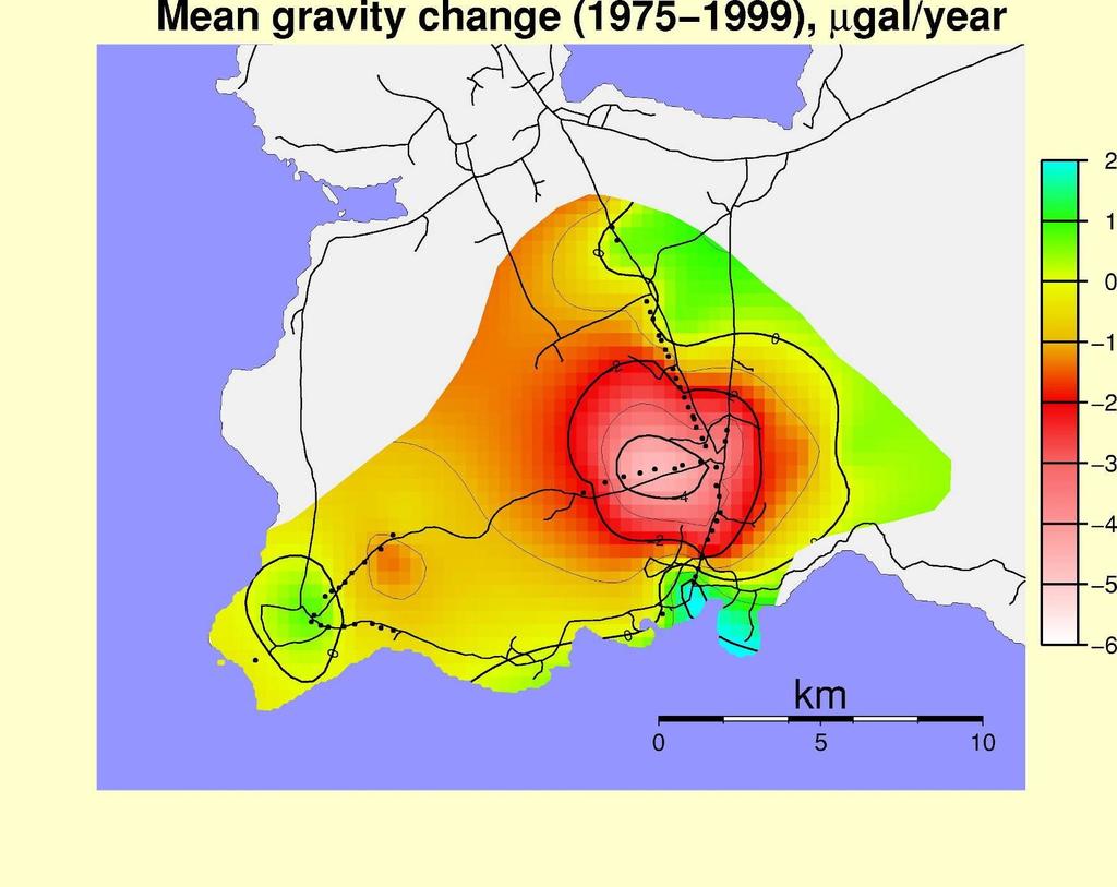


33 Svartsengi - Mean gravity change in µgal/year
34 Elastic waves seismic methods Elastic waves - different velocity in different rock types Refracted and reflected at discontinuities in formation Two types of elastic body waves: P-waves, wave movement in the travel direction S-waves material movement perpendicular to wave direction Seismic methods use this for info. on the geothermal system Two types of measurements Active methods not used routinely in geothermal expensive. Info. on density, porosity and texture; fluid-filled zones & temp. Include seismic refraction and seismic reflection Passive methods - seismic activity. Info. on active faults and permeable zones (shear wave splitting), S-wave shadow can indicate partial melt

35 Öxarfjördur Bouguer gravity & seismic cross-section
![Depth [km] Grid Northings [m] 9896000 9900000 9904000 9908000 [a] KM8 WE2 KM7 KR2 CE1 NE3 KM2 NE2 KM6 EP4 KR6 DM4 DM3 DM2 DM5 Olkaria Event distribution [b] 0-1 -2 KM5 OS1 DM1 0 2000](/docs-images/95/122584317/images/36-1.jpg "4000M 188000 192000 196000 200000 204000 208000 OWF OCF NEF-DOMES -3-4 -5-6 -7 0 2000 4000 M ORKUSTOFNUN -8 Kenya Short Course II - LSG 10.11.")
36 Depth [km] Grid Northings [m] [a] KM8 WE2 KM7 KR2 CE1 NE3 KM2 NE2 KM6 EP4 KR6 DM4 DM3 DM2 DM5 Olkaria Event distribution [b] KM5 OS1 DM M OWF OCF NEF-DOMES M ORKUSTOFNUN -8 Kenya Short Course II - LSG

37 Reykjanes Peninsula Seismic zone


38 Integrated results - Key to understanding - Ásgardur geothermal model based on soil temperature measurements, magnetic mapping and regional survey

39 Integrated results - Key to understanding Theistareykir aeromagnetic map & resistivity map
40 Selected references Árnason, K., and Flóvenz, Ó.G., 1992: Evaluation of physical methods in geothermal exploration of rifted volcanic crust. Geoth. Res. Council, Transactions, 16, Árnason, K., Karlsdóttir, R., Eysteinsson, H., Flóvenz, Ó.G., and Gudlaugsson, S.Th., 2000: The resistivity structure of high-temperature geothermal systems in Iceland. Proceedings of the World Geothermal Congress 2000, Kyushu- Tohoku, Japan, Björnsson, A., and Hersir, G.P., 1991: Geophysical exploration for geothermal resources, principles and applications. UNU G.T.P., Iceland, report 15, 94 pp. Flóvenz, Ó.G., and Saemundsson, K., 1993: Heat flow and geothermal processes in Iceland. Tectonophysics, 225, Keary, P., and Brooks, M., 1992: An introduction to geophysical exploration. Blackwell Scientific Publications, Oxford, 254 pp.


41 Thank you for the attention Vellir geyser
GEOPHYSICAL METHODS USED IN GEOTHERMAL EXPLORATION
 Presented at Short Course IV on Exploration for Geothermal Resources, organized by UNU-GTP, KenGen and GDC, at Lake Naivasha, Kenya, November 1-22, 2009. Kenya Electricity Generating Co., Ltd. GEOTHERMAL
INTERGRATED GEOPHYSICAL METHODS USED TO SITE HIGH PRODUCER GEOTHERMAL WELLS
 Presented at Short Course VII on Exploration for Geothermal Resources, organized by UNU-GTP, GDC and KenGen, at Lake Bogoria and Lake Naivasha, Kenya, Oct. 27 Nov. 18, 2012. GEOTHERMAL TRAINING PROGRAMME
RESISTIVITY OF ROCKS
 Presented at Short Course IV on Exploration for Geothermal Resources, organized by UNU-GTP, KenGen and GDC, at Lake Naivasha, Kenya, November 1-22, 2009. Kenya Electricity Generating Co., Ltd. GEOTHERMAL
Integrated Geophysical Model for Suswa Geothermal Prospect using Resistivity, Seismics and Gravity Survey Data in Kenya
 Proceedings World Geothermal Congress 2015 Melbourne, Australia, 19-25 April 2015 Integrated Geophysical Model for Suswa Geothermal Prospect using Resistivity, Seismics and Gravity Survey Data in Kenya
THE RESISTIVITY STRUCTURE OF HIGH-TEMPERATURE GEOTHERMAL SYSTEMS IN ICELAND
 . THE RESISTIVITY STRUCTURE OF HIGH-TEMPERATURE GEOTHERMAL SYSTEMS IN ICELAND Knutur Arnason 1, Ragna Karlsdottir 1, Hjalmar Eysteinsson 1, Olafur G Flovenz 1 and Steinar Thor Gudlaugsson 1 1 Orkustofnun,
Geophysical survey of a high-temperature field, Olkaria
 Presented at SDG Short Course I on Exploration and Development of Geothermal Resources, organized by UNU-GTP, GDC and KenGen, at Lake Bogoria and Lake Naivasha, Kenya, Nov. 10-31, 2016. Kenya Electricity
GEOTHERMAL EXPLORATION PHASE
 Presented at Short Course on Geothermal Project Management and Development, organized by UNU-GTP, KenGen and MEMD-DGSM, at the Imperial Botanical Beach Hotel, Entebbe, Uganda, November 20-22, 2008. GEOTHERMAL
Reykjavík. Hengill central volcano. 1. Geological map of SW-Iceland and location of Hengill central volcano and the Reykjavík capital.
 PROCEEDINGS, Thirty-Seventh Workshop on Geothermal Reservoir Engineering Stanford University, Stanford, California, January 30 - February 1, 2012 SGP-TR-194 PRELIMINARY STUDY OF DOWN-HOLE RESISTIVITY FROM
The Role of Magnetotellurics in Geothermal Exploration
 The Role of Magnetotellurics in Geothermal Exploration Adele Manzella CNR - Via Moruzzi 1 56124 PISA, Italy manzella@igg.cnr.it Foreword MT is one of the most used geophysical methods for geothermal exploration.
APPLICATION OF GEOPHYSICS TO GEOTHERMAL ENERGY EXPLORATION AND MONITORING OF ITS EXPLOITATION
 Presented at Short Course III on Exploration for Geothermal Resources, organized by UNU-GTP and KenGen, at Lake Naivasha, Kenya, October 24 - November 17, 2008. GEOTHERMAL TRAINING PROGRAMME Kenya Electricity
RESISTIVITY SURVEY IN THE HENGILL AREA, SW-ICELAND
 GEOTHERMAL TRAINING PROGRAMME Reports 2006 Orkustofnun, Grensásvegur 9, Number 21 IS-108 Reykjavík, Iceland RESISTIVITY SURVEY IN THE HENGILL AREA, SW-ICELAND Nyambayar Tsend-Ayush Department of Seismology
Characterizing a geothermal reservoir using broadband 2-D MT survey in Theistareykir, Iceland
 KMS Technologies KJT Enterprises Inc. An EMGS/RXT company Characterizing a geothermal reservoir using broadband 2-D MT survey in Theistareykir, Iceland Yu, G., Strack, K. M., Allegar, N., Gunnarsson, Á.
Borehole Geology and Alteration Mineralogy of Well He-52, Hellisheidi Geothermal Field, SW-Iceland
 Proceedings World Geothermal Congress 2015 Melbourne, Australia, 19-25 April 2015 Borehole Geology and Alteration Mineralogy of Well He-52, Hellisheidi Geothermal Field, SW-Iceland Moneer Fathel A. Alnethary
Geophysical exploration methods at European sites
 Geophysical exploration methods at European sites David Bruhn, GFZ Potsdam, Section 5.2 Geothermics, 14473 Potsdam, Germany Most geophysical exploration methods have been developed for the oil and gas
Comparison of 1-D, 2-D and 3-D Inversion Approaches of Interpreting Electromagnetic Data of Silali Geothermal Area
 Proceedings World Geothermal Congress 2015 Melbourne, Australia, 19-25 April 2015 Comparison of 1-D, 2-D and 3-D Inversion Approaches of Interpreting Electromagnetic Data of Silali Geothermal Area Charles
RESISTIVITY STRUCTURE OF PAKA GEOTHERMAL PROSPECT IN KENYA
 GEOTHERMAL TRAINING PROGRAMME Reports 2011 Orkustofnun, Grensasvegur 9, Number 26 IS-108 Reykjavik, Iceland RESISTIVITY STRUCTURE OF PAKA GEOTHERMAL PROSPECT IN KENYA Raymond M. Mwakirani Geothermal Development
Geothermal Surface Exploration in Iceland
 Proceedings World Geothermal Congress 2010 Bali, Indonesia, 25-29 April 2010 Geothermal Surface Exploration in Iceland Bjarni Richter, Benedikt Steingrímsson, Magnús Ólafsson and Ragna Karlsdóttir Iceland
Geophysical Exploration of High Temperature Geothermal Areas using Resistivity Methods. Case Study: TheistareykirArea, NE Iceland
 Proceedings World Geothermal Congress 2015 Melbourne, Australia, 19-25 April 2015 Geophysical Exploration of High Temperature Geothermal Areas using Resistivity Methods. Case Study: TheistareykirArea,
RESISTIVITY SURVEYING AND ELECTROMAGNETIC METHODS
 Presented at Short Course VII on Surface Exploration for Geothermal Resources, organized by UNU-GTP and LaGeo, in Santa Tecla and Ahuachapán, El Salvador, March 14-22, 2015. GEOTHERMAL TRAINING PROGRAMME
Exploration of Geothermal High Enthalpy Resources using Magnetotellurics an Example from Chile
 Exploration of Geothermal High Enthalpy Resources using Magnetotellurics an Example from Chile Ulrich Kalberkamp, Federal Institute for Geosciences and Natural Resources (BGR), Stilleweg 2, 30655 Hannover,
PROCESSING AND 1D INVERSION OF MAGNETOTELLURIC DATA FROM DUBTI AREA IN TENDAHO GEOTHERMAL FIELD, ETHIOPIA
 GEOTHERMAL TRAINING PROGRAMME Reports 2013 Orkustofnun, Grensasvegur 9, Number 37 IS-108 Reykjavik, Iceland PROCESSING AND 1D INVERSION OF MAGNETOTELLURIC DATA FROM DUBTI AREA IN TENDAHO GEOTHERMAL FIELD,
Geothermal Energy Resources Exploration using Gravity and magnetics. By Mariita, N.O. KenGen
 Geothermal Energy Resources Exploration using Gravity and magnetics By Mariita, N.O. KenGen What is Geothermal Energy? Geothermal Energy = heat from the Earth Transmitted by fluids via fractures and pores
Námafjall High Temperature Field in N Iceland. A 3D Resistivity Model Derived from MT Data
 Proceedings World Geothermal Congress 2015 Melbourne, Australia, 19-25 April 2015 Námafjall High Temperature Field in N Iceland. A 3D Resistivity Model Derived from MT Data Karlsdóttir R., Vilhjálmsson
PROCESSING AND JOINT 1D INVERSION OF MT AND TEM DATA FROM ALALLOBEDA GEOTHERMAL FIELD NE-ETHIOPIA
 Proceedings 6 th African Rift geothermal conference Addis Ababa, Ethiopia, 2 nd -4 th November 2016 PROCESSING AND JOINT 1D INVERSION OF MT AND TEM DATA FROM ALALLOBEDA GEOTHERMAL FIELD NE-ETHIOPIA Getenesh
THERMAL THERMAL AND AND RHEOLOGIC SIGNATURES OF
 THERMAL THERMAL AND AND RHEOLOGIC SIGNATURES OF OF HIGH HIGH ENTHALPY ENTHALPY RESOURCES ENGINE ENGINE Workshop Workshop Exploring Exploring high high temperature temperature reservoirs: reservoirs: new
Topic 7: Geophysical and Remote Sensing Models. Presenter: Greg Ussher Organisation:SKM
 Topic 7: Geophysical and Remote Sensing Models Presenter: Greg Ussher Organisation:SKM Email: gussher@globalskm.com Overview Surface-based imaging of subsurface characteristics That indicate geothermal
Characterizing a Geothermal Reservoir Using Broadband 2-D MT Survey in Theistareykir, Iceland
 Proceedings World Geothermal Congress 2 Bali, Indonesia, 259 April 2 Characterizing a Geothermal Reservoir Using Broadband 2-D MT Survey in Theistareykir, Iceland Gang Yu, Árni Gunnarsson 2, Zhanxiang
Electrical prospecting involves detection of surface effects produced by electrical current flow in the ground.
 Electrical Surveys in Geophysics Electrical prospecting involves detection of surface effects produced by electrical current flow in the ground. Electrical resistivity method Induced polarization (IP)
Geophysics Course Introduction to DC Resistivity
 NORAD supported project in MRRD covering Capacity Building and Institutional Cooperation in the field of Hydrogeology for Faryab Province Afghanistan Geophysics Course Introduction to DC Resistivity By
Geophysics for Environmental and Geotechnical Applications
 Geophysics for Environmental and Geotechnical Applications Dr. Katherine Grote University of Wisconsin Eau Claire Why Use Geophysics? Improve the quality of site characterization (higher resolution and
The Transient Electromagnetic method (TEM) in geothermal exploration. Processing and 1D inversion of a TEM sounding from Reykjanes, SW-Iceland
 in geothermal exploration. Processing and 1D inversion of a TEM sounding from Reykjanes, SW-Iceland") The Transient Electromagnetic method (TEM) in geothermal exploration. Processing and 1D inversion of a TEM sounding from Reykjanes, SW-Iceland Elías Eyþórsson Faculty of Earth Sciences University of Iceland
The Transient Electromagnetic method (TEM) in geothermal exploration. Processing and 1D inversion of a TEM sounding from Reykjanes, SW-Iceland Elías Eyþórsson Faculty of Earth Sciences University of Iceland
GRAVITY AND MAGNETIC METHODS
 Presented at Short Course IX on Exploration for Geothermal Resources, organized by UNU-GTP, GDC and KenGen, at Lake Bogoria and Lake Naivasha, Kenya, Nov. 2-24, 2014. Kenya Electricity Generating Co.,
APPENDICES TO THE REPORT: JOINT 1-D INVERSION OF TEM AND MT DATA FROM OLKARIA DOMES GEOTHERMAL AREA, KENYA
 GEOTHERMAL TRAINING PROGRAMME Reports 2009 Orkustofnun, Grensásvegur 9, Number 16 IS-108 Reykjavík, Iceland APPENDICES TO THE REPORT: JOINT 1-D INVERSION OF TEM AND MT DATA FROM OLKARIA DOMES GEOTHERMAL
WAMUNYU EDWARD MUREITHI I13/2358/2007
 WAMUNYU EDWARD MUREITHI I13/2358/2007 Olkaria geothermal area is situated south of Lake Naivasha on the floor of the southern segment of the Kenya rift. The geology of the Olkaria Geothermal area is subdivided
TORFAJÖKULL, ICELAND A RHYOLITE VOLCANO AND ITS GEOTHERMAL RESOURCE
 Presented at Short Course VI on Exploration for Geothermal Resources, organized by UNU-GTP, GDC and KenGen, at Lake Bogoria and Lake Naivasha, Kenya, Oct. 27 Nov. 18, 2011. GEOTHERMAL TRAINING PROGRAMME
Heat (& Mass) Transfer. conceptual models of heat transfer. large scale controls on fluid movement. distribution of vapor-saturated conditions
 Transfer. conceptual models of heat transfer. large scale controls on fluid movement. distribution of vapor-saturated conditions") Heat (& Mass) Transfer conceptual models of heat transfer temperature-pressure gradients large scale controls on fluid movement distribution of vapor-saturated conditions fluid flow paths surface manifestations
Heat (& Mass) Transfer conceptual models of heat transfer temperature-pressure gradients large scale controls on fluid movement distribution of vapor-saturated conditions fluid flow paths surface manifestations
NOTICE CONCERNING COPYRIGHT RESTRICTIONS
 NOTICE CONCERNING COPYRIGHT RESTRICTIONS This document may contain copyrighted materials. These materials have been made available for use in research, teaching, and private study, but may not be used
INTERPRETATION OF RESISTIVITY SOUNDINGS IN THE KRÝSUVÍK HIGH-TEMPERATURE GEOTHERMAL AREA, SW-ICELAND, USING JOINT INVERSION OF TEM AND MT DATA
 GEOTHERMAL TRAINING PROGRAMME Reports 2009 Orkustofnun, Grensásvegur 9, Number 9 IS-108 Reykjavík, Iceland INTERPRETATION OF RESISTIVITY SOUNDINGS IN THE KRÝSUVÍK HIGH-TEMPERATURE GEOTHERMAL AREA, SW-ICELAND,
GEOTHERMAL TRAINING PROGRAMME Reports 2012 Orkustofnun, Grensasvegur 9, Number 30 IS-108 Reykjavik, Iceland
 GEOTHERMAL TRAINING PROGRAMME Reports 2012 Orkustofnun, Grensasvegur 9, Number 30 IS-108 Reykjavik, Iceland ANALYSING THE SUBSURFACE RESISTIVITY STRUCTURE ON TWO PROFILES ACROSS THE NÁMAFJALL HIGH- TEMPERATURE
Geophysics for Geothermal Exploration
 Geophysics for Geothermal Exploration Dr. Hendra Grandis Geofisika - ITB Agenda Basic concept of Geophysics: : Review Geophysical signatures of a geothermal system Geophysical methods for geotermal exploration
GEOTHERMAL WELL SITING USING GIS: A CASE STUDY OF MENENGAI GEOTHERMAL PROSPECT
 GEOTHERMAL WELL SITING USING GIS: A CASE STUDY OF MENENGAI GEOTHERMAL PROSPECT Levi Shako Geothermal Development Company P. O Box 17700-20100, Nakuru, Kenya. lshako@gdc.co.ke ABSTRACT Geothermal well site
Exploring for geothermal reservoirs using broadband 2-D MT and gravity in Hungary
 KMS Technologies KJT Enterprises Inc. An EMGS/RXT company Exploring for geothermal reservoirs using broadband 2-D MT and gravity in Hungary Tulinius, H., Adám, L., Halldórsdóttir, H.,Yu, G., Strack, K.
POTASH DRAGON CHILE GEOPHYSICAL SURVEY TRANSIENT ELECTROMAGNETIC (TEM) METHOD. LLAMARA and SOLIDA PROJECTS SALAR DE LLAMARA, IQUIQUE, REGION I, CHILE
 METHOD. LLAMARA and SOLIDA PROJECTS SALAR DE LLAMARA, IQUIQUE, REGION I, CHILE") POTASH DRAGON CHILE GEOPHYSICAL SURVEY TRANSIENT ELECTROMAGNETIC (TEM) METHOD LLAMARA and SOLIDA PROJECTS SALAR DE LLAMARA, IQUIQUE, REGION I, CHILE OCTOBER 2012 CONTENT Page I INTRODUCTION 1 II FIELD
POTASH DRAGON CHILE GEOPHYSICAL SURVEY TRANSIENT ELECTROMAGNETIC (TEM) METHOD LLAMARA and SOLIDA PROJECTS SALAR DE LLAMARA, IQUIQUE, REGION I, CHILE OCTOBER 2012 CONTENT Page I INTRODUCTION 1 II FIELD
INFRARED AND SATELLITE IMAGES, AERIAL PHOTOGRAPHY
 Presented at Short Course VI on Exploration for Geothermal Resources, organized by UNU-GTP, GDC and KenGen, at Lake Bogoria and Lake Naivasha, Kenya, Oct. 27 Nov. 18, 2011. GEOTHERMAL TRAINING PROGRAMME
An Introduction to Geophysical Exploration
 An Introduction to Geophysical Exploration Philip Kearey Department of Earth Sciences University of Bristol Michael Brooks Ty Newydd, City Near Cowbridge Vale of Glamorgan Ian Hill Department of Geology
Application of Transient Electromagnetics for the Investigation of a Geothermal Site in Tanzania
 Application of Transient Electromagnetics for the Investigation of a Geothermal Site in Tanzania Gerlinde Schaumann, Federal Institute for Geosciences and Natural Resources (BGR), Stilleweg 2, 30655 Hannover,
Chapter 13. Groundwater
 Chapter 13 Groundwater Introduction Groundwater is all subsurface water that completely fills the pores and other open spaces in rocks, sediments, and soil. Groundwater is responsible for forming beautiful
Geophysical Methods in Geothermal Exploration
 Geochemical and Geophysical Methodologies in Geothermal Exploration Geophysical Methods in Geothermal Exploration by Adele Manzella Italian National Research Council International Institute for Geothermal
Principles of Applied Geophysics
 Principles of Applied Geophysics Fifth edition D.S. Parasnis Professor emeritus of Applied Geophysics Department of Applied Geophysics, University ofluled, Lulea, Sweden Fellow of the Royal Swedish Academy
Geophysics and Mapping. presented by: Stephen Brown
 Geophysics and Mapping presented by: Stephen Brown Recommended book for INIGEMM Geophysics for the mineral exploration geoscientist, by Michael Dentith and Stephen Mudge, Cambridge University Press, 2014.
GEOPHYSICAL FIELD MAPPING
 Presented at Short Course X on Exploration for Geothermal Resources, organized by UNU-GTP, GDC and KenGen, at Lake Bogoria and Lake Naivasha, Kenya, Nov. 9-Dec. 1, 2015. Kenya Electricity Generating Co.,
RESISTIVITY STRUCTURE OF THE EBURRU GEOTHERMAL FIELD, KENYA, DEPICTED THROUGH 1D JOINT INVERSION OF MT AND TEM DATA
 GEOTHERMAL TRAINING PROGRAMME Reports 2013 Orkustofnun, Grensasvegur 9, Number 26 IS-108 Reykjavik, Iceland RESISTIVITY STRUCTURE OF THE EBURRU GEOTHERMAL FIELD, KENYA, DEPICTED THROUGH 1D JOINT INVERSION
Improved Exploration, Appraisal and Production Monitoring with Multi-Transient EM Solutions
 Improved Exploration, Appraisal and Production Monitoring with Multi-Transient EM Solutions Folke Engelmark* PGS Multi-Transient EM, Asia-Pacific, Singapore folke.engelmark@pgs.com Summary Successful as
Preparation for a New Power Plant in the Hengill Geothermal Area, Iceland
 Proceedings World Geothermal Congress 2005 Antalya, Turkey, 24-29 April 2005 Preparation for a New Power Plant in the Hengill Geothermal Area, Iceland Einar Gunnlaugsson and Gestur Gíslason Reykjavik Energy,
HIGH TEMPERATURE HYDROTHERMAL ALTERATION IN ACTIVE GEOTHERMAL SYSTEMS A CASE STUDY OF OLKARIA DOMES
 Proceedings, 6 th African Rift Geothermal Conference Addis Ababa, Ethiopia, 2 nd 4 th November 2016 HIGH TEMPERATURE HYDROTHERMAL ALTERATION IN ACTIVE GEOTHERMAL SYSTEMS A CASE STUDY OF OLKARIA DOMES James
Exploring for geothermal reservoirs using broadband 2-D MT and gravity in Hungary
 KMS Technologies KJT Enterprises Inc. An EMGS/RXT company Exploring for geothermal reservoirs using broadband 2-D MT and gravity in Hungary Tulinius, H., Adám, L., Halldórsdóttir, H.,Yu, G., Strack, K.
A STUDY OF THE KRAFLA VOLCANO USING GRAVITY, MICRO EARTHQUAKE AND MT DATA
 Presented at Short Course VIII on Exploration for Geothermal Resources, organized by UNU-GTP, GDC and KenGen, at Lake Bogoria and Lake Naivasha, Kenya, Oct. 31 Nov. 22, 2013. GEOTHERMAL TRAINING PROGRAMME
Geoelectricity. ieso 2010
 Geoelectricity ieso 2010 1 RESISTIVITY SURVEY AT VENETO VILLA GRITTI AT THE TOWN OF TREVISO (VENETO REGION) The survey was carried out to verify the underground presence of the fondations of a rustic building.
ELECTRICAL RESISTIVITY TOMOGRAPHY
 NOTIO Association Clay Technological Centre C/ Río Cabriel s/n 45007 Toledo Tel.: 925 24 11 62 info@notio.es www.notio.es Page 1 / 7 SUMMARY 1. PHYSICAL FUNDAMENTALS OF THE... 3 1.1. ELECTRICAL BEHAVIOR
Geo-scientific Data Integration to Evaluate Geothermal Potential Using GIS (A Case for Korosi-Chepchuk Geothermal Prospects, Kenya)
") Geo-scientific Data Integration to Evaluate Geothermal Potential Using GIS (A Case for Korosi-Chepchuk Geothermal Prospects, Kenya) Levi Shako and Joseph Mutua Geothermal Development Company, P. O. Box
Geo-scientific Data Integration to Evaluate Geothermal Potential Using GIS (A Case for Korosi-Chepchuk Geothermal Prospects, Kenya) Levi Shako and Joseph Mutua Geothermal Development Company, P. O. Box
Essentials of Geology, 11e
 Essentials of Geology, 11e Groundwater Chapter 10 Instructor Jennifer Barson Spokane Falls Community College Geology 101 Stanley Hatfield Southwestern Illinois Co Jennifer Cole Northeastern University
3D Inversion of Magnetotelluric (MT) Resistivity Data from Krýsuvík High Temperature Geothermal Area in SW Iceland
 Resistivity Data from Krýsuvík High Temperature Geothermal Area in SW Iceland") Proceedings World Geothermal Congress 2015 Melbourne, Australia, 19-25 April 2015 3D Inversion of Magnetotelluric (MT) Resistivity Data from Krýsuvík High Temperature Geothermal Area in SW Iceland Gylfi
Proceedings World Geothermal Congress 2015 Melbourne, Australia, 19-25 April 2015 3D Inversion of Magnetotelluric (MT) Resistivity Data from Krýsuvík High Temperature Geothermal Area in SW Iceland Gylfi
Sustainable Energy Science and Engineering Center GEOTHERMAL ENERGY. Sustainable Energy Sources. Source:
 Sustainable Energy Sources GEOTHERMAL ENERGY Earth s Temperature Profile GEOTHERMAL ENERGY Plate Tectonics Earth's crust is broken into huge plates that move apart or push together at about the rate our
Euler Deconvolution JAGST Vol. 15(1) 2013
 2013") Euler Deconvolution JAGST Vol. 15(1) 2013 2D-EULER DECONVOLUTION AND FORWARD MODELING OF GRAVITY DATA OF HOMA-HILLS GEOTHERMAL PROSPECT, KENYA A. Odek 1, A. B. Otieno 1, W. J. Ambusso 1 and J. G. Githiri
Euler Deconvolution JAGST Vol. 15(1) 2013 2D-EULER DECONVOLUTION AND FORWARD MODELING OF GRAVITY DATA OF HOMA-HILLS GEOTHERMAL PROSPECT, KENYA A. Odek 1, A. B. Otieno 1, W. J. Ambusso 1 and J. G. Githiri
Western EARS Geothermal Geophysics Context Mar-2016 William Cumming
 Western EARS Geothermal Geophysics Context Mar-2016 William Cumming Cumming Geoscience, Santa Rosa CA wcumming@wcumming.com Office: +1-707-546-1245 Mobile: +1-707-483-7959 Skype: wcumming.com Kibiro Geophysics
1. Resistivity of rocks
 RESISTIVITY 1) Resistivity of rocks 2) General principles of resistivity surveying 3) Field procedures, interpretation and examples 4) Summary and conclusions INDUCED POLARIZATION 1) General principles
Geophysics and Geothermal Energy. Joseph Capriotti Meghan Helper Kendra Johnson Patricia Littman Gordon Osterman
 Geophysics and Geothermal Energy Joseph Capriotti Meghan Helper Kendra Johnson Patricia Littman Gordon Osterman Colorado School of Mines End of students junior year 4 week field camp Learning experience
Comparison of Down-Hole and Surface Resistivity Data from the Hellisheidi Geothermal Field, SW-Iceland
 Proceedings World Geothermal Congress 2010 Bali, Indonesia, 25-29 April 2010 Comparison of Down-Hole and Surface Resistivity Data from the Hellisheidi Geothermal Field, SW-Iceland Svanbjörg Helga Haraldsdóttir,
Department of Geophysics Faculty of Earth Sciences King Abdulaziz University
 Department of Geophysics Faculty of Earth Sciences King Abdulaziz University Dr. Mansour A. Al-Garni Office: room 233/Buld. 27 OR Dept. chair office/buld. 55 Introduction to Geophysics EGP 211 Time: 10-10:55
B7 Applications of DC resistivity exploration
 B7 Applications of DC resistivity exploration Modern DC resistivity surveys collect data for generating a 2-D or 3-D geoelectric model of the Earth. A simple 1-D analysis does not often yield results that
GEOTHERMAL POTENTIAL OF ST. KITTS AND NEVIS ISLANDS
 GEOTHERMAL POTENTIAL OF ST. KITTS AND NEVIS ISLANDS By Gerald W. Huttrer Geothermal Management Company, Inc. For the Eastern Caribbean Geothermal Energy Project ( Geo- Caraibes ; G-C ) Presented Using
BULLS-EYE! - SIMPLE RESISTIVITY IMAGING TO RELIABLY LOCATE THE GEOTHERMAL RESERVOIR
 BULLS-EYE! - SIMPLE RESISTIVITY IMAGING TO RELIABLY LOCATE THE GEOTHERMAL RESERVOIR Errol Anderson, Daryl Crosby and Greg Ussher PB Power GENZL Division, P O Box 3935, Auckland, New Zealand Key Words:
Applied Geophysics for Environmental Site Characterization and Remediation
 Applied Geophysics for Environmental Site Characterization and Remediation MSECA Webinar September 24, 2015 John Mundell, P.E., L.P.G. Ryan Brumbaugh, L.P.G. MUNDELL & ASSOCIATES, INC. Webinar Objective
Prof. Giuseppe Mandrone Prof. Cesare Comina dott. Luca Guglielmetti Dept. Earth Science, Univ. Torino (ITA)
") Prof. Giuseppe Mandrone Prof. Cesare Comina dott. Luca Guglielmetti Dept. Earth Science, Univ. Torino (ITA) Multidisciplinary approach of geothermal prospection at Terme di Vinadio/Valdieri (Cuneo - Italy):
Prof. Giuseppe Mandrone Prof. Cesare Comina dott. Luca Guglielmetti Dept. Earth Science, Univ. Torino (ITA) Multidisciplinary approach of geothermal prospection at Terme di Vinadio/Valdieri (Cuneo - Italy):
National Geophysical Survey Science Opportunities
 National Geophysical Survey Science Opportunities Anton Ziolkowski Professor of Petroleum Geoscience University of Edinburgh BGS Keyworth 4 April 2016 Outline Brief biography Science opportunities High
Verification and Validation Calculations Using the STAR Geophysical Postprocessor Suite
 SAIC-03/1040 Final Report Verification and Validation Calculations Using the STAR Geophysical Postprocessor Suite Prepared by: J. W. Pritchett December 2003 Verification and Validation Calculations Using
ambiguity in earth sciences IESO Geophysics Section Eddy hartantyo, Lab Geofisika FMIPA UGM
 ambiguity in earth sciences IESO Geophysics Section Eddy hartantyo, Lab Geofisika FMIPA UGM Pelatihan Tahap II IESO Teknik Geologi UGM Februari 2009 1 Introduction Photos from http://www.eegs.org/whatis/
HDR/EGS POTENTIAL OF THE VILKYCIAI AREA, WEST LITHUANIA
 HDR/EGS POTENTIAL OF THE VILKYCIAI AREA, WEST LITHUANIA Prepared by Saulius Sliaupa, Dainius Michelevicius, Gediminas Motuza, Larisa Korabliova, Kirstina Ciuraite West Lithuania is situated in the central
FUNDAMENTALS OF ENGINEERING GEOLOGY
 FUNDAMENTALS OF ENGINEERING GEOLOGY Prof. Dr. HUSSEIN HAMEED KARIM Building and Construction Engineering Department 2012 Preface The impulse to write this book stemmed from a course of geology given by
Three Dimensional Inversions of MT Resistivity Data to Image Geothermal Systems: Case Study, Korosi Geothermal Prospect
 PROCEEDINGS, 42nd Workshop on Geothermal Reservoir Engineering Stanford University, Stanford, California, February 13-15, 2017 SGP-TR-212 Three Dimensional Inversions of MT Resistivity Data to Image Geothermal
Geology and Hydrothermal Alteration of the Hverahlid HT-System, SW-Iceland
 Proceedings World Geothermal Congress 2010 Bali, Indonesia, 25-29 April 2010 Geology and Hydrothermal Alteration of the Hverahlid HT-System, SW-Iceland Steinþór Níelsson and Hjalti Franzson ISOR Iceland
3D INVERSION OF MT DATA IN GEOTHERMAL EXPLORATION: A WORKFLOW AND APPLICATION TO HENGILL, ICELAND
 PROCEEDINGS, Thirty-Seventh Workshop on Geothermal Reservoir Engineering Stanford University, Stanford, California, January 30 - February 1, 2012 SGP-TR-194 3D INVERSION OF MT DATA IN GEOTHERMAL EXPLORATION:
The Afar Rift Consortium
 The Afar Rift Consortium University of Bristol University of Oxford University of Cambridge British Geological Survey University of Rochester University of Auckland, NZ Opportunistic programme following
Earthquakes. Earthquakes are caused by a sudden release of energy
 Earthquakes Earthquakes are caused by a sudden release of energy The amount of energy released determines the magnitude of the earthquake Seismic waves carry the energy away from its origin Fig. 18.1 Origin
Groundwater Sustainability at Wadi Al Bih Dam, Ras El Khaimah, United Arab Emirates (UAE) using Geophysical methods
 using Geophysical methods") Groundwater Sustainability at Wadi Al Bih Dam, Ras El Khaimah, United Arab Emirates (UAE) using Geophysical methods Ahmed Murad, Amir Gabr, Saber Mahmoud, Hasan Arman & Abdulla Al Dhuhoori Geology Department
Groundwater Sustainability at Wadi Al Bih Dam, Ras El Khaimah, United Arab Emirates (UAE) using Geophysical methods Ahmed Murad, Amir Gabr, Saber Mahmoud, Hasan Arman & Abdulla Al Dhuhoori Geology Department
Conceptual model for non-volcanic geothermal resources - examples from Tohoku Japan
 Conceptual model for non-volcanic geothermal resources - examples from Tohoku Japan S. Tamanyu 1 and K. Sakaguchi 2 1, 2 Geological Survey of Japan, National Institute of Advanced Industrial Science and
LIGO sees binary neutron star merger on August 17, 2017
 LIGO sees binary neutron star merger on August 17, 2017 Laser Interferometer Gravitational-Wave Observatory (LIGO) Laser Interferometer Gravitational-Wave Observatory (LIGO) Multi-Messenger Astronomy This
Saskatchewan s Mineral Resources Lesson: Exploring for Minerals in Saskatchewan: Geophysics Using Magnetics to Find a Mine
 Saskatchewan s Mineral Resources Lesson: Exploring for Minerals in Saskatchewan: Geophysics Using Magnetics to Find a Mine Overview In this activity, students use the magnetic properties of iron nails
 12 10 8 6 4 2 0 40-50 50-60 60-70 70-80 80-90 90-100 Fresh Water What we will cover The Hydrologic Cycle River systems Floods Groundwater Caves and Karst Topography Hot springs Distribution of water in
Annað veldi ehf. Geothermal Provinces of Kenya
 Annað veldi ehf Geothermal Provinces of Kenya David Köndgen and Skuli Johannsson September 29, 2009 OUTLINE Overview Geology of Kenya Excursus: The Wilson Cycle How do rifts form? The world of Platetectonics
Global occurrence of geothermal systems in different geologic settings: their identification and utilization
 Global occurrence of geothermal systems in different geologic settings: their identification and utilization Mar-2016 William Cumming Cumming Geoscience, Santa Rosa CA wcumming@wcumming.com Office: +1-707-546-1245
Structural Geology tectonics, volcanology and geothermal activity. Kristján Saemundsson ÍSOR Iceland GeoSurvey
 Structural Geology tectonics, volcanology and geothermal activity Kristján Saemundsson ÍSOR Iceland GeoSurvey Discussion will be limited to rift zone geothermal systems with sidelook on hot spot environment.
3D MAGNETOTELLURIC SURVEY AT THE YANAIZU-NISHIYAMA GEOTHERMAL FIELD, NORTHERN JAPAN
 3D MAGNETOTELLURIC SURVEY AT THE YANAIZU-NISHIYAMA GEOTHERMAL FIELD, NORTHERN JAPAN Toshihiro Uchida 1, Shinichi Takakura 1, Takumi Ueda 1, Masaho Adachi 2, Hitoshi Ozeki 2, Kunikazu Kamada 3, Tatsuya
Data Fusion for Hydrothermal Reservoir Characterization through use of Bayesian Statistical Inference and MCMC Maximum Likelihood Models
 PROCEEDINGS, 42nd Workshop on Geothermal Reservoir Engineering Stanford University, Stanford, California, February 13-15, 2017 SGP-TR-212 Data Fusion for Hydrothermal Reservoir Characterization through
Keywords: Elevation, gravity, geothermal ABSTRACT
 ELEVATION AND GRAVITY CHANGES AT GEOTHEMAL FIELDS ON THE REYKJANES PENINSULA, SW ICELAND Hjalmar Eysteinsson Orkustofnun, Grensasvegi 9, 108 Reykjavik, Iceland Keywords: Elevation, gravity, geothermal
BRGM. Power from volcanic areas. started in Italy 1903 (Larderello, tuscany) ca 800 MWe today
 ca 800 MWe today") Power from volcanic areas started in Italy 1903 (Larderello, tuscany) ca 800 MWe today Conversion efficiency [%] 2 10 januari 2011 TNO Nieuwe huisstijl BRGM Geothermal power: Conversion Efficiency 25 20
Power from volcanic areas started in Italy 1903 (Larderello, tuscany) ca 800 MWe today Conversion efficiency [%] 2 10 januari 2011 TNO Nieuwe huisstijl BRGM Geothermal power: Conversion Efficiency 25 20
ENV-5004B/ENVK5005B. Figure 6. Student Registration No. ENV-5004B/ENVK5005B Version 2
 ENV-5004B/ENVK5005B Figure 6 Student Registration No UNIVERSITY OF EAST ANGLIA School of Environmental Sciences Main Series UG Examination 014-15 SOLID EARTH GEOPHYSICS SOLID EARTH GEOPHYSICS WITH FIELDCOURSE
NOTICE CONCERNING COPYRIGHT RESTRICTIONS
 NOTICE CONCERNING COPYRIGHT RESTRICTIONS This document may contain copyrighted materials. These materials have been made available for use in research, teaching, and private study, but may not be used
Ammon O. Omiti Kenya Electricity Generation P.o. Box Naivasha - Kenya
 Proceedings, 6 th African Rift Geothermal Conference Addis Ababa, Ethiopia, 2 nd 4 th November 2016 INVESTIGATION OF GEOLOGICAL STRUCTURES USING ELECTROMAGNETIC DOWN-HOLE TEMPERATURE AND WELL LOGS ON PETREL
Integrated interpretation of multimodal geophysical data for exploration of geothermal resources Case study: Yamagawa geothermal field in Japan
 Integrated interpretation of multimodal geophysical data for exploration of geothermal resources Case study: Yamagawa geothermal field in Japan Masashi Endo*(TechnoImaging), Alex Gribenko (TechnoImaging