Reconstructing the Groundwater Flow in the Baltic Basin During the Last Glaciation
|
|
|
- Ariel Fox
- 5 years ago
- Views:
Transcription


1 ESF projekts Starpnozaru zinātnieku grupas un modeļu sistēmas izveide pazemes ūdeņu pētījumiem Reconstructing the Groundwater Flow in the Baltic Basin During the Last Glaciation Tomas Saks, Juris Seņņikovs, Andrejs Timuhins, Andis Kalvāns IEGULDĪJUMS TAVĀ NĀKOTNĒ Līguma Nr. 2009/0212/1DP/ /09/APIA/VIAA/060
2 Contents The age of the groundwater in the Baltic Basin Glaciers and meltwater Model setup and data Results and discussion Conclusions ESF projekts Starpnozaru zinātnieku grupas un modeļu sistēmas izveide pazemes ūdeņu pētījumiem Līguma Nr. 2009/0212/1DP/ /09/APIA/VIAA/060
3 The age of the groundwater in the Baltic Basin Groundwater in the Baltic Basin, according to its chemical and isotope composition can be subdivided into three broad age groups: Contemporary (Last 10 th. y.) Pleistocene (glacial and interglacial) Ancient Pre-Quaternary
4 The water of glacial origin δo 18 values of groundwater in the Vendian Cambrian aquifer system in North Estonia (Radla, 2010).

5 Glacial history of the Baltic Basin The Baltic Basin has been covered by the Scandinavian ice sheets at least 4 times The last, Late Weichselian, glaciation was present in the Baltic Basin territory for at least 19 thousand years Svedsen et al., 2004

6 The last deglaciation in the territory of the Baltic Basin Kalm, 2010.
7 Thermal regime of the glaciers Cuffey&Patterson, 2010 Most of the large ice sheets are warmbased, that is their bed temperature is at pressure-melting point

8 Subglacial water flow A Supraglacial lake; B Surface streams; C Swamp zones near the edge of the firn; D Moulins; E Crevasses F Water filled fractures G Subglacial tunnels H Runoff from the glacier Surface meltwater intrudes the glacier base via network of conduits connecting supraglacial water bodies and the glacier base Some meltwater can be generated at the base of the glacier itself due to geothermal heat flow and ice deformation heat Most of the water is drained along the ice/bed interface Through R channels Through N channels Through cavity system
 Slopes of the glacier surface and its base controls the water flow")
9 Subglacial water flow A Supraglacial lake; B Surface streams; C Swamp zones near the edge of the firn; D Moulins; E Crevasses F Water filled fractures G Subglacial tunnels H Runoff from the glacier For ideally plastic glacier ice water pressure at the base of the glacier is equal to the weight of the glacier (Patterson, 1994) Slopes of the glacier surface and its base controls the water flow direction at the glacier base α=-11β
10 Subglacial groundwater recharge Intrusion of the glacier water is controlled By the water conductivity of the sediments at the glacier base The permafrost, that can permanently lock any open pores in the sediments Groundwater pressure in the aquifer
11 The possible timing of glacial water intrusion in the Baltic Basin The Middle Weichselian (~53ka ~26ka): cold climate conditions between two advances of Scandinavian glaciation Late Weichselian glaciation (12 28 t.g.): subglacial reacharg Baltic Ice Lake(12-10 t.g.), deglaciation stage of last glaciation: subglacial recharge

12 Intrusion of the glacier water After Mokrik & Mažeika, 2002 During the Baltic Ice Lake stage as an intrusion through the taliks in permafrost (Mokrik, Mažeika, 2002)
13 Intrusion of the glacier water Intrusion of the meltwater from the glacier is favoured, because: Most of the glacier bed is expected to be at the temperate conditions in the ablation zone Subglacial permafrost is expected to be thawed by the end of the glaciation Very large pressure gradients existed several thousands of years
14 Aim of the modelling During the last glaciation: Was the pressure gradient sufficient enough to reverse the interglacial (like modern) groundwater flow direction in the CM-V system? What were groundwater flow direction and velocities? What was the volume of the meltwater intruded?
15 Model setup and data

16 Tallinn Model setup Riga Vilnius Vendian Cambrian aquifer Calibrated MOSYS/BAB V0 Geometry corrected for subglacial topography: subsidence of Earth crust surface due to ice weight On the surface constant pressure boundary condition calculated from ice thickness data was applied 19 consecutive modelling steps spanning the time from 10 28ka BP thru the last glacial advance and deglaciation


17 Input data 28ka 21ka 15ka Ice thickness data for 10 28ka BP in 1 ka intervals (Argus, Peltier, 2010)


18 Input data 28ka 21ka 15ka Subglacial topography data for 10 28ka BP in 1 ka intervals (Argus&Peltier, 2010)
19 Results

20 Groundwater flow directions 18ka Two main areas of meltwater intrusion into the Cm-V aquifer system: around Narva and Gotland The Western intrusion area has been present for longer time periods


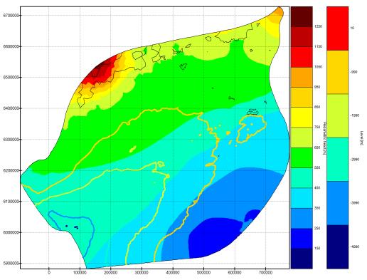

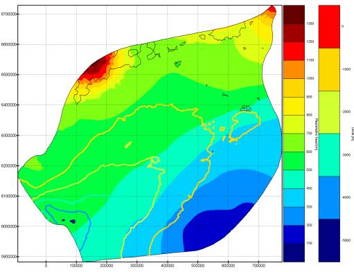
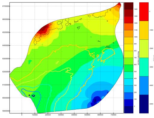

21 Groundwater flow during the last glaciation 12ka 13ka 15ka 16ka 17ka 18ka 19ka 21ka 28ka

22 Maximum velocities near the intrusion Groundwater flow velocity modules at around one order of magnitude greater than in modern conditions Flow velocities
23 Volume and distance of the meltwater intruded Assuming that the intrusion window was 750 km long and 150 m thick: the total water volume intruded into the Cm-V aquifer system during the 14 th years of glaciation could be up to ~ 2.2*10 12 m 3 If the average porosity is 20% this will result in The distance of the intrusion amounts to ~ 100 km penetration If the 95% of the meltwater intruded into 2 aquifers of total thickness ~ 50m the depth of the intrusion would be extends to 270 km, corresponding to 2.0*10 12 m 3

24 Lower Devonian aquifer system 19ka Lower Devonian aquifer system: a likely candidate to contain glacial meltwater as models suggest large regional pressure gradient during the last glaciation
25 Identified problems and the future work 1 Basal till distribution: The water conductivity of the subglacial sediments is one of the main factors directly influencing the volume of the meltwater intruded and the flow velocities of the groundwater Even a relatively thin till layer of low conductivity can slow down the subglacial groundwater recharge The till distributing and thickness is changing as ice sheet evolves Permafrost: Unknown distribution and thickness before the advance of glacier and in periglacial area Unknown rate of degradation under the ice sheet
26 Identified problems and the future work 2 Buried valleys in Northern Estonia: These could serve as intensified infiltration windows Uncertainty of the glacial history: the ice distribution, subglacial meltwater availability, glacioisostasic depression of Earth crust The currently defined Eastern boundary of the Baltic Basin is irrelevant for the periods when groundwater flow was controlled by the glacier: the model should be extended Eastwards
27 Conclusions
28 Conclusions Two potential intrusion areas for the Baltic basin: in the East around Narva and in the west around Gotland Reversed (as to present) groundwater flow direction could exist for up to 14 thousand years during the last glacial advance At the present model setup the meltwater intrusion from the glacier can explain most of the glacier water presence in the Cm-V aquifer system, although only the last glacial advanc was considered Model results are likely over-estimations, as several factors, that could hamper subglacial groundwater recharge were not accounted for
29 References Cuffey K.M., Patterson W.S.B The physics of glaciers. 4th edition. Elsevier. 636p. Mokrik R., Mažeika J. Paleohydrogeological reconstruction of groundwater recharge durinf Late Weichselian in the Baltic Basin. Geologija. Vilnius. No. 39. P Patterson W.S.B The physics of glaciers 3rd. Edition. Elsevier. 480p. Raidla V (2010) Chemical and isotope evolution of groundwater in the Cambrian-Vendian aquifer system in Estonia., Dissertationes Geologicae Universitatis Tartuensis 28, Tartu: Tartu Ülikooli Kirjastus Saks, T., Kalvans, A., Zelčs, V. In press. OSL dating evidence of Middle Weichselian age of shallow basin sediments in Western Latvia, Eastern Baltic. Quaternary Science Reviews. Svendsen, J.I. et al. 2004: Late Quaternary ice sheet history of northern Eurasia. Quaternary Science Reviews, 23,


30 Thanks for your attention! ESF projekts Starpnozaru zinātnieku grupas un modeļu sistēmas izveide pazemes ūdeņu pētījumiem Līguma Nr. 2009/0212/1DP/ /09/APIA/VIAA/060
Tomas Saks, ĢZZF. ESF projekts Starpnozaru zinātnieku grupas un modeļu sistēmas izveide pazemes ūdeņu pētījumiem
 ESF projekts Starpnozaru zinātnieku grupas un modeļu sistēmas izveide pazemes ūdeņu pētījumiem Modelling the influence of the Pleistocene glaciatiations on the groundwater flow in the Baltic Basin Pleistocēna
MECHANISMS OF GROUNDWATER RECHARGE IN THE BALTIC ARTESIAN BASIN
 and modelling system for groundwater research MECHANISMS OF GROUNDWATER RECHARGE IN THE BALTIC ARTESIAN BASIN Alise BABRE 1, Rein VAIKMÄE 2, Tõnu MARTMA 2, Konrāds POPOVS 1, Aija DĒLIŅA 1 1 University
Glacial Modification of Terrain
 Glacial Modification Part I Stupendous glaciers and crystal snowflakes -- every form of animate or inanimate existence leaves its impress upon the soul of man. 1 -Orison Swett Marden Glacial Modification
Ice on Earth: An overview and examples on physical properties
 Ice on Earth: An overview and examples on physical properties - Ice on Earth during the Pleistocene - Present-day polar and temperate ice masses - Transformation of snow to ice - Mass balance, ice deformation,
FORMATION OF GROUNDWATER IN SEDIMENTARY BASINS: TRADITIONAL AND ALTERNATIVE MODELS
 FORMATION OF GROUNDWATER IN SEDIMENTARY BASINS: TRADITIONAL AND ALTERNATIVE MODELS Albertas Bitinas Klaipėda University, Coastal Research and Planning Institute, H. Manto St. 84, Klaipėda, Lithuania, albertas.bitinas@corpi.ku.lt
How do glaciers form?
 Glaciers What is a Glacier? A large mass of moving ice that exists year round is called a glacier. Glaciers are formed when snowfall exceeds snow melt year after year Snow and ice remain on the ground
STABLE ISOTOPES AS RECORD OF CLIMATIC CHANGES OF DANIGLACIAL IN LITHUANIA
 GEOCHRONOMETRIA Vol. 20, pp 81-86, 2001 Journal on Methods and Applications of Absolute Chronology STABLE ISOTOPES AS RECORD OF CLIMATIC CHANGES OF DANIGLACIAL IN LITHUANIA ALGIRDAS GAIGALAS 1, ANNA PAZDUR
Lecture 10 Glaciers and glaciation
 Lecture 10 Glaciers and glaciation Outline Importance of ice to people! Basics of glaciers formation, classification, mechanisms of movement Glacial landscapes erosion and deposition by glaciers and the
What is a Glacier? Types of Glaciers
 Alpine & Continental Glaciers Glacial Mass Balance Glacial Ice Formation Glacial Movement & Erosion Erosional and Depositional Landforms The Pleistocene Epoch Geomorphology of SW Manitoba Chapter 17 1
INDEX_Glaciers.pdf. mountain (alpine) glacier NLG Test bank: [Glaciers01-03.jpg] High Quality: [Moraine_med-lat_Haines_AK_.jpg]
![INDEX_Glaciers.pdf. mountain (alpine) glacier NLG Test bank: [Glaciers01-03.jpg] High Quality: [Moraine_med-lat_Haines_AK_.jpg]](/thumbs/83/88580835.jpg "INDEX_Glaciers.pdf. mountain (alpine) glacier NLG Test bank: [Glaciers01-03.jpg] High Quality: [Moraine_med-lat_Haines_AK_.jpg]") Glaciers_INDEX.pdf This is an index of all terms/ideas in this question bank. Question banks are organized into topics containing related terms/ideas. Each term/idea has at least one related question,
Glaciers_INDEX.pdf This is an index of all terms/ideas in this question bank. Question banks are organized into topics containing related terms/ideas. Each term/idea has at least one related question,
T. Perron Glaciers 1. Glaciers
 T. Perron 12.001 Glaciers 1 Glaciers I. Why study glaciers? [PPT: Perito Moreno glacier, Argentina] Role in freshwater budget o Fraction of earth s water that is fresh (non-saline): 3% o Fraction of earth
Glacial processes and landforms NGEA01, 2014
 Glacial processes and landforms NGEA01, 2014 Cecilia Akselsson Department of Physical Geography and Ecosystem Science Lund University Geomorphological processes and landforms all over the world Periglacial
Neogene Uplift of The Barents Sea
 Neogene Uplift of The Barents Sea W. Fjeldskaar A. Amantov Tectonor/UiS, Stavanger, Norway FORCE seminar April 4, 2013 The project (2010-2012) Funding companies Flat Objective The objective of the work
Glaciers form wherever snow and ice can accumulate High latitudes High mountains at low latitudes Ice temperatures vary among glaciers Warm
 The Cryosphere Glaciers form wherever snow and ice can accumulate High latitudes High mountains at low latitudes Ice temperatures vary among glaciers Warm (temperate) glaciers: at pressure melting point,
Changing Landscapes: Glaciated Landscapes. How do glaciers move?
 Changing Landscapes: Glaciated Landscapes How do glaciers move? What you need to know Differences between cold-and warm-based glaciers, their locations and rates of movement Glacier ice movement including
PHYSICAL GEOGRAPHY. By Brett Lucas
 PHYSICAL GEOGRAPHY By Brett Lucas GLACIAL PROCESSES Glacial Processes The Impact of Glaciers on the Landscape Glaciations Past and Present Types of Glaciers Glacier Formation and Movement The Effects of
Glaciers. (Shaping Earth s Surface, Part 6) Science 330 Summer 2005
 Science 330 Summer 2005") Glaciers (Shaping Earth s Surface, Part 6) Science 330 Summer 2005 1 Glaciers Glaciers are parts of two basic cycles Hydrologic cycle Rock cycle Glacier a thick mass of ice that originates on land from
Glaciers (Shaping Earth s Surface, Part 6) Science 330 Summer 2005 1 Glaciers Glaciers are parts of two basic cycles Hydrologic cycle Rock cycle Glacier a thick mass of ice that originates on land from
Reconstruction of the Vistula ice stream lobe during LGM: preliminary results of the research project
 Ice, water, humans Quaternary landscape evolution in the Peribaltic Region 35th Annual conference of the German Quaternary Association DEUQUA e.v. 12th Annual Conference of the INQUA PeriBaltic WG 13th-17th
4. What type of glacier forms in a sloping valley between rock walls? a. firn glacier b. ice sheet c. cirque d. alpine glacier
 Multiple Choice Questions 1. The term means the loss of snow and ice by evaporation and melting. a. sublimation b. ablation c. erosion d. abrasion 2. What condition must be met for a glacier to begin flowing
Glaciers Earth 9th Edition Chapter 18 Glaciers: summary in haiku form Key Concepts Glaciers Glaciers Glaciers Glaciers
 1 2 3 4 5 6 7 8 9 10 11 12 13 14 Earth 9 th Edition Chapter 18 : summary in haiku form Ten thousand years thence big glaciers began to melt - called "global warming." Key Concepts and types of glaciers.
Mathematical model of Baltic artesian basin
 Mathematical model of Baltic artesian basin Juris Sennikovs, Janis Virbulis, and Uldis Bethers Laboratory for Mathematical Modelling of Environmental and Technological Processes UNIVERSITY OF LATVIA Contents
QUATERNARY AND GLACIAL GEOLOGY
 QUATERNARY AND GLACIAL GEOLOGY JURGEN EHLERS Geologisches Landesamt, Germany Translated from Allgemeine und historische Quartdrgeologie English version by Philip L. Gibbard JOHN WILEY & SONS Chichester
Glacier Hydrology. Why should you care?
 Glacier Hydrology Why should you care? Climate Local Meteorology Surface Mass And Energy Exchange Net Mass Balance Dynamic Response Effect on Landscape Changes In Geometry Water Flow PRACTICAL MATTERS:
Groundwater flow beneath Late Weichselian glacier ice in Nordfjord, Norway
 84 Journal of Glaciology, Vol. 53, No. 180, 2007 Groundwater flow beneath Late Weichselian glacier ice in Nordfjord, Norway Carolyn A. MOELLER, D.M. MICKELSON, M.P. ANDERSON, C. WINGUTH Department of Geology
Prentice Hall EARTH SCIENCE
 Prentice Hall EARTH SCIENCE Tarbuck Lutgens Chapter 7 Glaciers, Desert, and Wind 7.1 Glaciers Types of Glaciers A glacier is a thick ice mass that forms above the snowline over hundreds or thousands of
Ice Sheets and Glaciers
 Ice Sheets and Glaciers Technical University of Denmark Kees van der Veen Department of Geography University of Kansas Why are glaciers and ice sheets important? Large volume of fresh water stored in ice
Supraglacial Lake Formation and What it Means for Greenland s Future
 Supraglacial Lake Formation and What it Means for Greenland s Future GreenPeace Ulyana Nadia Horodyskyj GEOG 5271 questions of interest How, when and where do these lakes form in Greenland? How do these
Extra Credit Assignment (Chapters 4, 5, 6, and 10)
") GEOLOGY 306 Laboratory Instructor: TERRY J. BOROUGHS NAME: Extra Credit Assignment (Chapters 4, 5, 6, and 10) For this assignment you will require: a calculator and metric ruler. Chapter 4 Objectives:
GEOLOGY 306 Laboratory Instructor: TERRY J. BOROUGHS NAME: Extra Credit Assignment (Chapters 4, 5, 6, and 10) For this assignment you will require: a calculator and metric ruler. Chapter 4 Objectives:
Lowland Glaciation North Wales
 Lowland Glaciation North Wales Background Although there have been many glaciations and advances in ice, the most significant for this are was the Dimlington Stadial which was a period of glacial advance
Periglacial Geomorphology
 Periglacial Geomorphology Periglacial Geomorphology Periglacial: literally means around glacial - term introduced in 1909 to describe landforms and processes around glaciated areas. Periglacial environments:
ATOC OUR CHANGING ENVIRONMENT
 ATOC 1060-002 OUR CHANGING ENVIRONMENT Class 22 (Chp 15, Chp 14 Pages 288-290) Objectives of Today s Class Chp 15 Global Warming, Part 1: Recent and Future Climate: Recent climate: The Holocene Climate
ENIGMA: something that is mysterious, puzzling, or difficult to understand.
 Lecture 12. Attempts to solve the Eccentricity Enigma ENIGMA: something that is mysterious, puzzling, or difficult to understand. Milankovitch forcing glacier responses pre-900,000 yr BP glacier responses
Michigan s Geology and Groundwater
 Michigan s Geology and Groundwater Ralph J. Haefner Deputy Director U.S. Geological Survey Michigan-Ohio Water Science Center Lansing, Michigan Outline About the USGS Geology 101 Michigan s geology Bedrock
4 Formation of glacial ice 3. 5 Formation of glacial ice (cont.) 3. 6 Glacier economy and general flow structure 4
 3. 6 Glacier economy and general flow structure 4") Contents 1 Glacier Flow 2 2 Definition 2 3 Amount 3 4 Formation of glacial ice 3 5 Formation of glacial ice (cont.) 3 6 Glacier economy and general flow structure 4 7 Example 5 8 Examples 6 9 Ice movement
Contents 1 Glacier Flow 2 2 Definition 2 3 Amount 3 4 Formation of glacial ice 3 5 Formation of glacial ice (cont.) 3 6 Glacier economy and general flow structure 4 7 Example 5 8 Examples 6 9 Ice movement
Lecture 21: Glaciers and Paleoclimate Read: Chapter 15 Homework due Thursday Nov. 12. What we ll learn today:! Learning Objectives (LO)
") Learning Objectives (LO) Lecture 21: Glaciers and Paleoclimate Read: Chapter 15 Homework due Thursday Nov. 12 What we ll learn today:! 1. 1. Glaciers and where they occur! 2. 2. Compare depositional and
Learning Objectives (LO) Lecture 21: Glaciers and Paleoclimate Read: Chapter 15 Homework due Thursday Nov. 12 What we ll learn today:! 1. 1. Glaciers and where they occur! 2. 2. Compare depositional and
Modelling of surface to basal hydrology across the Russell Glacier Catchment
 Modelling of surface to basal hydrology across the Russell Glacier Catchment Sam GAP Modelling Workshop, Toronto November 2010 Collaborators Alun Hubbard Centre for Glaciology Institute of Geography and
Evidence for Permafrost on Long Island
 Evidence for Permafrost on Long Island By Vesna Kundic and Gilbert N. Hanson Department of Geosciences Stony Brook University Permafrost or permanently frozen ground is soil or rock that remains below
Match up the pictures and key terms
 Match up the pictures and key terms 1 Plucking Striations 3 Roche Mountonnees 2 Chatter Marks 4 What is the difference between plucking and abrasion? Glacial Processes Erosion, Weathering and Deposition
RIVERS, GROUNDWATER, AND GLACIERS
 RIVERS, GROUNDWATER, AND GLACIERS Delta A fan-shaped deposit that forms when a river flows into a quiet or large body of water, such as a lake, an ocean, or an inland sea. Alluvial Fan A sloping triangle
Bell Ringer. Are soil and dirt the same material? In your explanation be sure to talk about plants.
 Bell Ringer Are soil and dirt the same material? In your explanation be sure to talk about plants. 5.3 Mass Movements Triggers of Mass Movements The transfer of rock and soil downslope due to gravity is
Glacier Thermodynamics: Ice Temperature and Heat Transfer Processes
 Glacier Thermodynamics: Ice Temperature and Heat Transfer Processes ESS431: Principles of Glaciology ESS505: The Cryosphere Wednesday, 10/24 Ben Hills Today s Objectives: Why do we care about ice temperature?
Outline 23: The Ice Ages-Cenozoic Climatic History
 Outline 23: The Ice Ages-Cenozoic Climatic History Continental Glacier in Antarctica Valley Glaciers in Alaska, note the moraines Valley Glaciers in Alaska, note the moraines Mendenhall Glacier, Juneau,
39 Mars Ice: Intermediate and Distant Past. James W. Head Brown University Providence, RI
 39 Mars Ice: Intermediate and Distant Past James W. Head Brown University Providence, RI james_head@brown.edu 37 Follow the Water on Mars: 1. Introduction: Current Environments and the Traditional View
Lecture Outlines PowerPoint. Chapter 6 Earth Science 11e Tarbuck/Lutgens
 Lecture Outlines PowerPoint Chapter 6 Earth Science 11e Tarbuck/Lutgens 2006 Pearson Prentice Hall This work is protected by United States copyright laws and is provided solely for the use of instructors
SVALBARD. Environmental changes in Svalbard since the last glacial maximum THE ROLE OF PERMAFROST
 SVALBARD Environmental changes in Svalbard since the last glacial maximum THE ROLE OF PERMAFROST Bernd Etzelmüller, Oslo, Norway With contribution by Hanne H. Christiansen, UNIS, Svalbard Discussion points
Chapter 5: Glaciers and Deserts
 I. Glaciers and Glaciation Chapter 5: Glaciers and Deserts A. A thick mass of ice that forms over land from the compaction and recrystallization of snow and shows evidence of past or present flow B. Types
Soils, Hydrogeology, and Aquifer Properties. Philip B. Bedient 2006 Rice University
 Soils, Hydrogeology, and Aquifer Properties Philip B. Bedient 2006 Rice University Charbeneau, 2000. Basin Hydrologic Cycle Global Water Supply Distribution 3% of earth s water is fresh - 97% oceans 1%
Glacial Geomorphology Lecture 1: Glaciers & Glacial Environments. GGY 166: Geomorphology of Southern Africa
 Glacial Geomorphology Lecture 1: Glaciers & Glacial Environments GGY 166: Geomorphology of Southern Africa Relevance in Southern African Context South African landscape has been influenced by glacial action
Quick Clay: (Leda Clay gone bad!) Origin, Mineralogy, Chemistry and Landslides
 Origin, Mineralogy, Chemistry and Landslides") Quick Clay: (Leda Clay gone bad!) Origin, Mineralogy, Chemistry and Landslides What is Leda Clay? The fine-grained (silty clay and clayey silt) sediments that accumulated in the St. Lawrence drainage basin,
Quick Clay: (Leda Clay gone bad!) Origin, Mineralogy, Chemistry and Landslides What is Leda Clay? The fine-grained (silty clay and clayey silt) sediments that accumulated in the St. Lawrence drainage basin,
The Geology of Sebago Lake State Park
 Maine Geologic Facts and Localities September, 2002 43 55 17.46 N, 70 34 13.07 W Text by Robert Johnston, Department of Agriculture, Conservation & Forestry 1 Map by Robert Johnston Introduction Sebago
On Notation Thermodynamics of Glaciers. Types of Glaciers. Why we care. McCarthy Summer School
 On Notation Thermodynamics of Glaciers McCarthy Summer School Andy Aschwanden Geophysical nstitute University of Alaska Fairbanks, USA (hopefully) consistent with Continuum Mechanics (Truffer) with lots
Foundations of Earth Science, 6e Lutgens, Tarbuck, & Tasa
 Foundations of Earth Science, 6e Lutgens, Tarbuck, & Tasa Glacial and Arid Landscapes Foundations, 6e - Chapter 4 Stan Hatfield Southwestern Illinois College Glaciers Glaciers are parts of two basic cycles
Landscape. Review Note Cards
 Landscape Review Note Cards Last Ice Age Pleistocene Epoch that occurred about 22,000 Years ago Glacier A large, long lasting mass of ice which forms on land and moves downhill because of gravity. Continental
CARD #1 The Shape of the Land: Effects of Crustal Tilting
 CARD #1 The Shape of the Land: Effects of Crustal Tilting When we look at a birds-eye view of the Great Lakes, it is easy to assume the lakes are all at a similar elevation, but viewed in this way, we
Impact of the Danube River on the groundwater dynamics in the Kozloduy Lowland
 GEOLOGICA BALCANICA, 46 (2), Sofia, Nov. 2017, pp. 33 39. Impact of the Danube River on the groundwater dynamics in the Kozloduy Lowland Peter Gerginov Geological Institute, Bulgarian Academy of Sciences,
SAMPLE PAGE. pulses. The Ice Age By: Sue Peterson
 Page 61 Objective sight words (pulses, intermittent, isotopes, chronicle, methane, tectonic plates, volcanism, configurations, land-locked, erratic); concepts (geological evidence and specific terminology
P228 Geological Storage of CO2 Prospects in the Baltic States
 P228 Geological Storage of CO2 Prospects in the Baltic States A. Shogenova* (Tallinn University of Technology), S. Sliaupa (Institute of Geology and Geography, Vilnius), K. Shogenov (Tallinn University
Science Olympiad Dynamic Earth: Glaciers
 Science Olympiad Dynamic Earth: Glaciers Write the appropriate response next to the corresponding number on the answer sheet. 1. Name 2 aspects of a glacier that define it as such (questions #1-2, 1 point
 12 10 8 6 4 2 0 40-50 50-60 60-70 70-80 80-90 90-100 Fresh Water What we will cover The Hydrologic Cycle River systems Floods Groundwater Caves and Karst Topography Hot springs Distribution of water in
3. GEOLOGY. 3.1 Introduction. 3.2 Results and Discussion Regional Geology Surficial Geology Mine Study Area
 3. GEOLOGY 3.1 Introduction This chapter discusses the baseline study of the geology and mineralization characteristics of the mine study area. The study consolidates existing geological data and exploration
How to Use This Presentation
 How to Use This Presentation To View the presentation as a slideshow with effects select View on the menu bar and click on Slide Show. To advance through the presentation, click the right-arrow key or
basal } 0.01 m a -1 Glacier hydrology Glacier hydrology Glacier hydrology Water sources 2nd part: applied glaciology
 Glacier hydrology GEO 4420, 19.10.2006 Glacier hydrology Relevance: Water resource (climate change scenario) Ice dynamics (sliding, surge, icestreams) Geo-hazards (outburst floods) (Erosion, sediment transport)
The landforms of Svalbard
 The landforms of Svalbard Content Periglacial landforms -) ice-wedges -) rock glaciers -) pingos -) solifluction -) avalanches -) debris flows -) rock falls -) nivation -) aeolian landforms Glacial landforms
Geology and New England Landscapes
 Geology and New England Landscapes Jim Turenne, CPSS USDA-NRCS Warwick, RI. http://nesoil.com Why Geology? Provides the big picture of site conditions. Major part of soil formation (parent material and
UNIT 4: Earth Science Chapter 21: Earth s Changing Surface (pages )
") CORNELL NOTES Directions: You must create a minimum of 5 questions in this column per page (average). Use these to study your notes and prepare for tests and quizzes. Notes will be turned in to your teacher
CORNELL NOTES Directions: You must create a minimum of 5 questions in this column per page (average). Use these to study your notes and prepare for tests and quizzes. Notes will be turned in to your teacher
Impact of permafrost on repository safety
 Impact of permafrost on repository safety IGD TP Exchange Forum, Prague, 29 October 2013 Ton Wildenborg (TNO) Richard Shaw (BGS) Simon Norris (NDA) My presentation Uncertainties Permafrost related processes
Topic 2: Landscape Systems, Processes and Change
 Topic 2: Landscape Systems, Processes and Change Option 2A: Glaciated Landscapes and Change Overview Ice sheets and glaciers operate within a landscape system as glacial processes of erosion, transport
Maximum Extent of Pleistocene Glaciation - 1/3 of land surface Most recent glacial maximum peaked 18,000 years ago and is considered to have ended
 Glaciers Maximum Extent of Pleistocene Glaciation - 1/3 of land surface Most recent glacial maximum peaked 18,000 years ago and is considered to have ended 10,000 B.P. Current Extent of Glaciation - about
Name: Mid-Year Review #2 SAR
 Name: Mid-Year Review #2 SAR Base your answers to questions 1 through 3 on on the diagram below, which shows laboratory materials used for an investigation of the effects of sediment size on permeability,
167: Subglacial Drainage
 167: Subglacial Drainage MARTIN SHARP Department of Earth and Atmospheric Sciences, University of Alberta, Edmonton, AB, Canada Subglacial drainage can occur wherever ice at a glacier bed reaches the pressure
1. Any process that causes rock to crack or break into pieces is called physical weathering. Initial product = final product
 Weathering 1. Any process that causes rock to crack or break into pieces is called physical weathering. Initial product = final product End Result of physical weathering is increased surface area. 2. Physical
Groundwater in Sedimentary Basins
 The 70 th Scientific Conference of the University of Latvia Session of Geology Section Groundwater in Sedimentary Basins ABSTRACT BOOK The 70 th Scientific Conference of the University of Latvia Session
Modeled and observed fast flow in the Greenland ice sheet
 Modeled and observed fast flow in the Greenland ice sheet Ed Bueler 1 Constantine Khroulev 1 Andy Aschwanden 2 Ian Joughin 3 1 Dept of Mathematics and Statistics, University of Alaska Fairbanks 2 Arctic
11/22/2010. Groundwater in Unconsolidated Deposits. Alluvial (fluvial) deposits. - consist of gravel, sand, silt and clay
 deposits. - consist of gravel, sand, silt and clay") Groundwater in Unconsolidated Deposits Alluvial (fluvial) deposits - consist of gravel, sand, silt and clay - laid down by physical processes in rivers and flood plains - major sources for water supplies
Groundwater in Unconsolidated Deposits Alluvial (fluvial) deposits - consist of gravel, sand, silt and clay - laid down by physical processes in rivers and flood plains - major sources for water supplies
Thermodynamics of Glaciers
 Thermodynamics of Glaciers McCarthy Summer School, June 2010 Andy Aschwanden Arctic Region Supercomputing Center University of Alaska Fairbanks, USA McCarthy Summer School, June 2010 1 / 34 On Notation
Amazing Ice: Glaciers and Ice Ages
 Amazing Ice: Glaciers and Ice Ages Updated by: Rick Oches, Professor of Geology & Environmental Sciences Bentley University Waltham, Massachusetts Based on slides prepared by: Ronald L. Parker, Senior
Greenland subglacial drainage evolution regulated by weakly-connected regions of the bed
 Greenland subglacial drainage evolution regulated by weakly-connected regions of the bed Matthew Hoffman Stephen Price Lauren Andrews Ginny Catania Weakly-connected Drainage Distributed Drainage Channelized
Glacier Hydrology II: Theory and Modeling
 Glacier Hydrology II: Theory and Modeling McCarthy Summer School 2018 Matt Hoffman Gwenn Flowers, Simon Fraser Operated by Los Alamos National Security, LLC for the U.S. Department of Energy's NNSA Observations
BLAKENEY ESKER AND HOW IT FORMED. The Blakeney Esker is a ridge, around 3.5 km in length, which runs southeastwards
 BLAKENEY ESKER AND HOW IT FORMED Introduction The Blakeney Esker is a ridge, around 3.5 km in length, which runs southeastwards from west of Blakeney, to Wiveton Downs, north-west of Glandford, in north
2/23/2009. Visualizing Earth Science. Chapter Overview. Deserts and Drylands. Glaciers and Ice Sheets
 Visualizing Earth Science By Z. Merali and B. F. Skinner Chapter 6 Deserts, Glaciers and Ice Sheets Chapter Overview Deserts and Drylands Glaciers and Ice Sheets Deserts Geography Categorization of deserts
June 9, R. D. Cook, P.Eng. Soils Engineer Special Services Western Region PUBLIC WORKS CANADA WESTERN REGION REPORT ON
 PUBLIC WORKS CANADA WESTERN REGION REPORT ON GEOTECHNICAL INVESTIGATION PROPOSED MARTIN RIVER BRIDGE MILE 306.7 MACKENZIE HIGHWAY Submitted by : R. D. Cook, P.Eng. Soils Engineer Special Services Western
Lake Levels and Climate Change in Maine and Eastern North America during the last 12,000 years
 Maine Geologic Facts and Localities December, 2000 Lake Levels and Climate Change in Maine and Eastern North America during the last 12,000 years Text by Robert A. Johnston, Department of Agriculture,
Outline 24: The Holocene Record
 Outline 24: The Holocene Record Climate Change in the Late Cenozoic New York Harbor in an ice-free world (= Eocene sea level) Kenneth Miller, Rutgers University An Ice-Free World: eastern U.S. shoreline
Assessment of possible jôkulhlaups from Lake Demmevatn in Norway
 The Eslrciui's of flu' Extremes: Eflraortlinarv Floods (Proceedings of ;i svinposinm held ill Reykjavik. Iceland. July 2000). IAliSPubl.no. 271. 2002. 31 Assessment of possible jôkulhlaups from Lake Demmevatn
This is an author produced version of Actively evolving subglacial conduits and eskers initiate ice shelf channels at an Antarctic grounding line.
 This is an author produced version of Actively evolving subglacial conduits and eskers initiate ice shelf channels at an Antarctic grounding line. White Rose Research Online URL for this paper: http://eprints.whiterose.ac.uk/113417/
GEOL.3250 Geology for Engineers Glacial Geology
 GEOL.3250 Geology for Engineers Glacial Geology NAME Part I: Continental Glaciation Continental glaciers are large ice sheets that cover substantial portions of the land area. In the region of accumulation
Glaciers. A glacier is a persistent mass of ice: snow accumulation exceeds melting. generally occur in two areas: high latitudes, or high elevations
 Page 1 of7 Glaciers A glacier is a persistent mass of ice: snow accumulation exceeds melting generally occur in two areas: high latitudes, or high elevations hence CONTINENTAL and ALPINE glaciation Glaciers
Glaciology (as opposed to Glacial Geology) Why important? What are glaciers? How do they work?
 Why important? What are glaciers? How do they work?") Glaciology (as opposed to Glacial Geology) Why important? What are glaciers? How do they work? Glaciers are important because of their role in creating glacial landscapes (erosional and depositional features).
Glaciology (as opposed to Glacial Geology) Why important? What are glaciers? How do they work? Glaciers are important because of their role in creating glacial landscapes (erosional and depositional features).
Periglacial processes, features & landscape development /4 Glacial Systems and landscapes
 Periglacial processes, features & landscape development 3.1.4.3/4 Glacial Systems and landscapes What you need to know Where periglacial landscapes are found and what their key characteristics are The
Chapter 14: Groundwater. Fig 14.5b
 Chapter 14: Groundwater Fig 14.5b OBJECTIVES Recognize that groundwater is a vital source of accessible freshwater. Describe how groundwater forms below the water table. Explain the origin of aquifers,
Subglacial Control on Glacier Flow in Northern Greenland
 Subglacial Control on Glacier Flow in Northern Greenland Beáta Csathó (University at Buffalo, SUNY, Buffalo, NY), C.J. van der Veen (U. of Kansas, Lawrence, KS) Ralph van Frese and Tim Leftwich (The Ohio
THE EARTH S RELIEF SOCIAL SCIENCES 1º ESO
 THE EARTH S RELIEF SOCIAL SCIENCES 1º ESO 1. THE STRUCTURE OF THE EARTH The Earth is divided into layers: The crust is the surface layer. It is a thin, solid layer made of rock. The Earth s crust has a
v. Dvareckas, A. Gaigalas, B. Viliinaite
 POSTER SESSIONS 197 DEPENDENCY OF CARTOGRAPHlCAL VIEW OF THE HYDROGRAPHICAL NETWORK IN LITHUANIAN UPON THE TOPOGRAPHY v. Dvareckas, A. Gaigalas, B. Viliinaite Department of General Geography and Cartography
Permafrost-influenced Geomorphic Processes
 Section 4 Permafrost-influenced Geomorphic Processes Geomorphic processes vary greatly among ecoregions in northern Alaska, extending from the Beaufort Sea coast to the Brooks Range (Figure 4.1). Regional
GEOLOGY CURRICULUM. Unit 1: Introduction to Geology
 Chariho Regional School District - Science Curriculum September, 2016 GEOLOGY CURRICULUM Unit 1: Introduction to Geology OVERVIEW Summary In this unit students will be introduced to the field of geology.
Associate Professor in Glacial Geology and Geomorphology Faculty of Geography and Earth Science, Univ. of Latvia
 Curriculum Vitae PERSONAL INFORMATION Vitālijs Zelčs Academic Centre of Science, University of Latvia, Jelgavas iela 1, Room 230, Rīga, Latvia vitalijs.zelchs@lu.lv WORK EXPIERENCE 2002 current Professor
Sea level change. Eustatic sea level change. Tectono-eustasy. Tectonic control of global sea level. Global signal of sea level change Causes:
 Sea level change Important processes Global vs. local Geologic Modern Current rates of rise Observations, calculations, and models Lessons from the past Projected future changes Eustatic sea level change
Use of SWAT to Scale Sediment Delivery from Field to Watershed in an Agricultural Landscape with Depressions
 Use of SWAT to Scale Sediment Delivery from Field to Watershed in an Agricultural Landscape with Depressions James E. Almendinger St. Croix Watershed Research Station, Science Museum of Minnesota Marylee
Constraints on the lake volume required for hydro-fracture through ice sheets
 Click Here for Full Article GEOPHYSICAL RESEARCH LETTERS, VOL. 36, L10501, doi:10.1029/2008gl036765, 2009 Constraints on the lake volume required for hydro-fracture through ice sheets M. J. Krawczynski,
This graph best represents the elements of the Earth's A) lithosphere B) hydrosphere C) troposphere D) stratosphere
 lithosphere B) hydrosphere C) troposphere D) stratosphere") 1. Surface ocean currents resulting from the prevailing winds over the oceans illustrate a transfer of energy from A) lithosphere to atmosphere B) hydrosphere to lithosphere C) atmosphere to hydrosphere
1. Surface ocean currents resulting from the prevailing winds over the oceans illustrate a transfer of energy from A) lithosphere to atmosphere B) hydrosphere to lithosphere C) atmosphere to hydrosphere