Basinal Configuration And Intrasediment Intrusives As Revealed By Aeromagnetics Data Of South East Sector Of Mamfe Basin, Nigeria.
|
|
|
- Adrian Dalton
- 5 years ago
- Views:
Transcription
1 IOSR Journal of Applied Geology and Geophysics (IOSR-JAGG) e-issn: , p-issn: Volume 1, Issue 5 (Nov. Dec. 2013), PP Basinal Configuration And Intrasediment Intrusives As Revealed By Aeromagnetics Data Of South East Sector Of Mamfe Basin, Nigeria. OBI, D. A. 1. OBI, E. O. 2 OKIWELU, A. A. 3 1.Department of Geology University of calabar 2.Cross River State University of Technology, Calabar.3.Department of Physics, University of Calabar Abstract: Five aeromagnetic maps on a scale of 1:100,000 were analysed using the horizontal gradient magnitude and 2.5D forward modeling method in the South east Sector of mamfe basin Nigeria. The data was manually digitized and filtered using polynomial fitting method to obtain a residual map, reduction to the pole was done after map merging prior to filtering. The HDep and Saki softwares were used in determining the sediments thickness, types of intrusive, and basin configuration. The results identified (17) seventeen intrusives and the basin configuration made of horst and graben structures, the sediment thickness from both methods range between 0.5km 4.3km, the areas with the highest accumulation of sediments (2.6km 4.3km) is within Edor area in Bansara, these area also has three major intrusives which may serve as a source of heat for thermal maturation or over maturation of these sediments. Keywords: configuration,forward modeling, polynomial fitting I. Introduction The South eastern Mamfe basin is a sedimentary basin that border Cross River State in Nigeria and South Western Cameroon. The present study is restricted to the Nigeria sector of the Mamfe basin which extents from latitude N and longitude E.-(fig1). The determination of sediments thickness, types of intrusives, and basin configuration was done with the use of several suites of potential field softwares from the united state geological surveys (USGS). Tectonic Setting The South east Nigerian sector of mamfe basin is a segment of the lower Benue trough which is a linear intracratonic graben trending NE-SW. It s origin is associated with the separation of Africa and South American Continent in the early cretaceous. Reviews on the geology of the trough have been presented by several workers (eg. Petters, 1982; Obaje, 1994; Alkande and Erdman, 1998, Chiadiobi, 2010). Also previous geophysical surveys over the Benue trough reveal a crustal thinning beneath the Benue trough, (Ajakaiye, 1981; Adighije, 1979; Ofoegbu, 1995; and Okereke, 1984) flanked on both sides by linear sub-basins. The mamfe sub-basin forms part of the lower Benue trough which is surrounded by Oban massif that extend to the Obudu Plateau, which stretches to form part of the Bamenda massif in Cameroon republic. The rift system which forms the lower Benue trough had several episodes of folding of the sediments which were deposited structurally in three segments from massif to cenomanian, these sediment accumulation form s part of the mamfe sub basin deposits. Geology The oldest sedimentary rocks in the study area is the Asu river group (Albian) which comprise of sandstone, shales and lime stones, these sediments lies unconformably on the precambrain basement (granites, and biotite gnesses). Overlying the Asu river group is the Eze-Aku formation (Turonian) which comprise of shales and their lateral equivalents of Agwu formation (mode, 1997). These sedimentary rocks lies unconformably on the Asu river group, the new Basalts (tertiary) are latter emplacements within these cretaceous sediments (Fig. 2). Theoritical Background Horizontal gradient magnitude: This method is a simple approach to estimating contact locations and dm depth (Phillips 1997, Blakely and Simpson, 1986). If m (x,y) is the magnetic field and are dm and dx dy derivatives in the x and y directions, then the horizontal gradient magnitude HGM (x,y) is given by: 1 Page
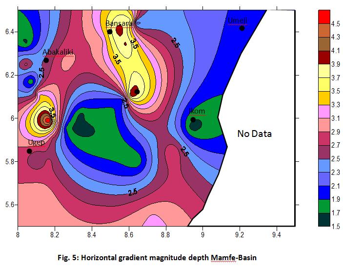
2 HGM ( x, y) dm dx 2 dm dy equ (1) This function peaks over magnetic contacts under the following assumption (i), the regional magnetic field is vertical (ii) contacts are vertical (iii) sources are thick, these assumptions may break down in practice, but the approach remains the least susceptible to noise in the data because it only requires the calculations of the two first order horizontal derivatives of the magnetic field. Generally, the theoretical shape of the horizontal gradient magnitude over a contact is given by K HGM equ. (2) 2 2 h d Where he is the horizontal distance to the contact, d = depth to the top of the contact and k = a constant. Due to the assumptions of thick sources, the depth estimate made using this procedure represent minimum depths (Olagundoye 2004, Phillip s 1997, Pilkinglon & Kealing 2006). Modeling: Modeling may be defined as a process from which one tries to deduce effect of comparison to observations with the aim of developing a better understanding of the observations. Forward magnetic modeling is the art of estimating the geometry of the magnetic source or distribution of magnetization with the source by trial and error (Dobrin & Sarvit 1988). Forward modeling is a quantitative approach that involves making numerical estimates of the depth and dimension of sources (Reeves, 2005) most times the model parameter are adjusted in other to obtain a better agreement between observed and calculated anomalies. II. Data Analysis Five aeromagnetic total intensity field maps on a scale of 1:100,000 were acquired from the Geological survey agency, Kaduna. The survey was conducted along E-W profiles with flight line spacing of 2.0 km and a tie line spacing of 20.0km and a flight elevation of km above sea level (Table 1.) The geomagnetic gradient was removed using the international geomagnetic reference field (I. G. R. F) formula of first January The mangnetic maps were digitaized at 1.0 km to avoid the problem of frequency alaizing, further processing of the data was done with the use of the United State Geological Services potential field software version 2.0. The software package has suites of programmes (A2xY2), PZGRD, GEOCON, HDEP, SURFIT, MFNIT, MFFILTER, MFEDSIGN, SAKI, JMEGER, FRTP and P< contour). All the digntized data was manually done by extracting the coordinates of x and y at discrete point intervals along flight lines and their respective Z value for total field intensively determined. The A2xY2 Software was used in converting the data from binary to ascii and the P2GRD and J merger softwares used to grid and map-merge the data set. The merged data was contoured using Geocon and Pc contour software to produce the total magnetic field map of the study area (fig. 3). Reduction to pole was done using FR-TP software where individual anomalies were properly centered prior to data filtering. The reduced to the pole data was filtering using the polynomial filling method where the sufit software was used to obtain the residual after the regional was subtracted from the observed data, the P-C contour software was then used to contour the residual data to obtain the residual map of the study area (fig.4). Further analysis in determining depth to magnetic sources and basin configuration were made using HDEP and Saki softwares. The output of the residual data was used in modeling the structure of the subsurface, this data was also used in HDEP software for determining the horizontal gradient magnitude for depth to source of magnetic basement solutions. The output of HDEP generated 180 solutions points to generate the horizontal gradient magnitude map contoured using surfer 7.0 (fig. 5). The forward modeling was done along profile lines choosen perpendicular to major magnetic anomalies, the Saki software was used for this modeling, the residual data was used as input, the process requires generation of an observed plot from the input data and a calculated plot generated through imput of various parameters such as total field Azimuth, inclination, declination, and no of bodies, no of vertices (Table 2)These parameters are changed until a perfect match is obtained between the observed and calculated output with a minimum percentage error of < 5% (Phillips 1997, Obi et al 2008, Olagudoye 2004). Five profiles were modeled and the output of the modeled results are shown in figures 6, 7, 8, 9, 10, and table 2.0. III. Results The residual map (fig.4) has five model profile lines which were carefully choosen across major magnetic anomalies and the results obtained from the model profiles are compared with those obtained from the horizontal gradient magnitude (fig.5). 2 Page
3 Depth to magnetic source using the horizontal gradient magnitude (HGM) shows that the bansara area ranges between 3.5km-4.1km, and saki model depth of km (fig.5), these area has the highest depth range in the study area. The Abakalilli area has HGM depth of 1.5km 2.5km with saki model depths ranging 1.0km - 2.3km (fig. 5,7), Ikom area has HGM depths ranging between 1.5km 2.2km with saki model depth ranging between km (fig. 5,8). The adjacent Umaji area has HGM depths ranging between km with saki model depths ranging between km (fig 5, 9). Also the Ugep area has HGM depths ranging between km with saki model depths ranging between km (Fig 5, 10). The saki models (fig 6, 7,8,9,10) were constrained by different parameters as listed above, the forward models reveal different types of intrusive (table 2). A total of (17) seventeen intrusive were encountered at different locations of the study area. The Umaji and Ikom area has basaltic intrusive while gneisses and Rhys dominated other areas (Table 2.) IV. Disscussion / Conclusion The area around Ikom and its surrounding environs of Ugep, Bansara and Abakaliki has been studied using the horizontal gradient magnitude method for source to magnetic basement determination, and forward modeling for subsurface basin configuration. The result of depth to magnetic basement using both the HGM and saki forward modeling are well collobrated indicating areas of uplifts (Horst) averaging 0.5km-2.0km and depression (Grabens) km. The Bansara area has the highest depth of sediment accumulation reaching depths 4.1km. The sediment Thickness decreased towards the Umaji area 0.5km, Ikom area km and Ugep area km. Also, the Bansara (Edor) areas is the adjacent basin towards Ogoja from the Aballaliki uplifted areas with depth reaching 0.8km 2.3km The shallow depth area of Umaji, Ikom and Ugep has (12) twelve intrusives, usually the area is less favourable for hydrocarbon exploration activities. However the area around Bansara (Mfum) which has sediments thickness about 4.1km has three intrusives whose presence may serve as a source of heat for thermal maturation or over maturation of these sediments, this area remain the most favourable area for hydrocarbon prospecting within the mamfe basin. The numerous presence of basaltic intrusive and the shallow depths of sediments within Ikom Umaji, and Ugep make the areas less favourable for hydrocarbon exploration activities. Conclusively, exploration for hydrocarbon activities in the Nigerian sector of the mamfe basin should be concentrated in the Mfum-Edor areas of Bansara. S/N Sheet Sheet Flight line Fight line Tie line Flight altitude (km) Name Number Direction (degree) Spacing (km) Spacing (km) 1 Ikom / Abakaliki / Bansara / Mukuru / Ugep / Table 1.0 Flight line parameter Profile name Declinat ion Declinat ion Azimu th Tot al field (NT ) No of Instrusi ves No of vert ex No of bodi ed Dept. sedime nts Susceptibil ities of intrusives Abakal iki Bansar a Umaji Ikom Types of intrusive Basalt Basalt Basalt RMS % Profi le lengt h (km) Page
![Ugep - - 76 0-4 35 13 0.5-1.0 0.025 0.025 Table 2.0 Summary of modeled profile / statistics 1.5 23.2 References [1]. Adighije, C. I. (1981). Gravity study of the Lower Benue Trough, Nigeria Geol Mag.](/docs-images/92/108099196/images/4-0.jpg ", 118 (1), 59-67. [2]. Ajakaiye, D. E., (1981) Geophysical Investigation in the Benue Trough Review Earth Evol. Sci, 2, 110-125. [3]. Akpan, E. B and Nyong, E. E. (1987).")
4 Ugep Table 2.0 Summary of modeled profile / statistics References [1]. Adighije, C. I. (1981). Gravity study of the Lower Benue Trough, Nigeria Geol Mag., 118 (1), [2]. Ajakaiye, D. E., (1981) Geophysical Investigation in the Benue Trough Review Earth Evol. Sci, 2, [3]. Akpan, E. B and Nyong, E. E. (1987). Trace fossil assemblage and depositional environment of Turonian Calcareous sandstones in Southern Benue Trough, Nigeria. J. African Earth Sci. 6, pp [4]. Beltrao, J. E.Silva, J. B, C and Coasta, J. C. (1991). Robust Polynomial fitting method for regional gravity estimation. Geophysics 56 (1), [5]. Blakely, R. J. and Simpson, R. W (1986). Approximating edges of source bodies from magnetic and gravity anomalies Geophysics, 51 (7), [6]. Dobrin, M. B. and Saviit, H. (1988). Introduction to Geophysical prospecting (4 th ed ) Newyork: McGraw-Hill Book Company. [7]. Fairhead, J. D. and Okereke, C. S. (1987). A regional gravity study of the West African rift system in Nigeria and Cameroon and it s tectonic interpretation. Techonophysics, 143, [8]. Kangkolo, R., (2002). Aeromagnetic study of the mamfe basalts of South Western Cameroon. Journal of the Cameroon Academy of sciences vol. 2 no 3. Ichnostratigraphy and paleoenvironments of the Benue trough, Nigeria. Journal of mining and Geology vol. 33 No2 pp [9]. Obi, D. A., Okereke, C. S., Egeh, U. E. and Olagundoye, O. O., (2008). Aeromagnetic modeling in evaluating the hydrocarbon potential of the basement of the Calabar flank, South eastern Nigeria Journal of mining and Geology vol 44 (2) pp [10]. Okereke, C. S., Otoegbu, C. O, and Ezeayim V. I. (1990). Cretaceous sediment thickness in the Benue trough gravity Interpretation. Bolletino DiGeotisica Teorica Ed Applicata, 32, [11]. Ofoegbu, C. O., (1984). Intepretation of aeromagnetic anomalies over the lower and middle Benue trough Geophys. J. R Astron Soc. 79, [12]. Ofoegbu, C. O., (1991). Analysis of magnetic data over the Abakaliki Anticlinorium of the lower Benue Trough, Nigeria Marine and Petroleum Geology, Vol 8. pp [13]. Olagundoye, O. O. (2004). Geophysical study of the basin structure of the Anambra frontier basin, S. E Nigeria Ph.D thesis, University of Calabar, Nigeria. [14]. Petters, S. W. (1978a). Stratigraphic evolution of the Benue Trough and it s implication for the upper createceous paleogeography of West Africa J. Geol, 78 pp [15]. Phillips, J. D. (1997). Potential field Geophysical software for the PC, version 2.2 U. S Geological survey Open-file Report , [16]. Pilkington, M. and Keating, P., (2006). The relationship between local wave number and analytical signal in magnetic interpretation Geophysics vol 71, pp L-1 to L-3. [17]. Reeves, C., (2005). Aeromagnetic surveys principles, practice and Interpretation. wwwgeosoft. Com. [18]. Roest, W. R.; Verthoef, J. and Pilkington, M.; (1992). Magnetic Interpretation using 3-D analytical signal. Geophysics Vol. 57 pp Fig.1 Location map of the study area 4 Page

5 Fig.2 Geologic Map of the study area Fig.3 Total Magnetic Field Intensity Map of the study area 5 Page
6 6 Page
7 7 Page
8 8 Page
Application of Ground and Aeromagnetics as Reconnaissance tool for Hydrocarbon Exploration in Part of Ikom Embayment and Lower Benue Trough, Nigeria.
 IOSR Journal of Applied Geology and Geophysics (IOSR-JAGG) e-issn: 2321 0990, p-issn: 2321 0982.Volume 4, Issue 5 Ver. III (Sep. - Oct. 2016), PP 14-23 www.iosrjournals.org Application of Ground and Aeromagnetics
Aeromagnetic Study of Oil Seepage along the Basement Flanks of Part of the Lower Benue Trough, South Eastern Nigeria
 IOSR Journal of Applied Geology and Geophysics (IOSR-JAGG) e-issn: 2321 0990, p-issn: 2321 0982.Volume 1, Issue 4 (Sep. Oct. 2013), PP 22-29 Aeromagnetic Study of Oil Seepage along the Basement Flanks
Interpretation of aeromagnetic data over the Bida Basin, North Central, Nigeria
 Available online at www.pelagiaresearchlibrary.com Advances in Applied Science Research, 2015, 6(3): 50-63 ISSN: 0976-8610 CODEN (USA): AASRFC Interpretation of aeromagnetic data over the Bida Basin, North
Journal of Environment and Earth Science ISSN (Paper) ISSN (Online) Vol.4, No.7, 2014
 ISSN (Online) Vol.4, No.7, 2014") ISSN 2224-3216 (Paper) ISSN 2225-0948 0948 (Online) Aeromagnetic Anomalies Modeling and nd Their Tectonic Implications in the he Middle Benue Trough, Nigeria OBI, D. A. *, MENKITI. R. C., OKEREKE, C. S.
ISSN 2224-3216 (Paper) ISSN 2225-0948 0948 (Online) Aeromagnetic Anomalies Modeling and nd Their Tectonic Implications in the he Middle Benue Trough, Nigeria OBI, D. A. *, MENKITI. R. C., OKEREKE, C. S.
Spectral Analysis of Aeromagnetic Anomalies from Parts of Mmaku and its Adjoining Areas in Southeastern, Nigeria
 International Journal of Scientific and Research Publications, Volume 5, Issue 10, October 2015 1 Spectral Analysis of Aeromagnetic Anomalies from Parts of Mmaku and its Adjoining Areas in Southeastern,
Evaluation of the petroleum potentials and prospect of the Chad Basin Nigeria from heat flow and gravity data
 J Petrol Explor Prod Technol (2012) 2:1 6 DOI 10.1007/s13202-011-0015-5 ORIGINAL PAPER - EXPLORATION GEOPHYSICS Evaluation of the petroleum potentials and prospect of the Chad Basin Nigeria from heat flow
AIRBORNE MAGNETIC STUDY OF OTUKPO AREA. Ogah, Vincent E. and B. S. Jatau 1
 AIRBORNE MAGNETIC STUDY OF OTUKPO AREA Ogah, Vincent E. and B. S. Jatau 1 Department of Geology, Benue State Polytechnic, Ugbokolo 2 Department of Geology and Mining, Nasarawa State University, Keffi ABSTRACT:
INTEGRATED GEOPHYSICAL INVESTIGATION OF SEQUENCE OF DEPOSITION OF SEDIMENTARY STRATA IN ABAKALIKI, NIGERIA ABSTRACT
 INTEGRATED GEOPHYSICAL INVESTIGATION OF SEQUENCE OF DEPOSITION OF SEDIMENTARY STRATA IN ABAKALIKI, NIGERIA Agha S.O Dept. of Industrial Physics Ebonyi State University, Abakaliki, Nigeria & Arua A.I Dept.
DETERMINATION OF THE CURIE POINT DEPTH OF ANAMBRA BASIN AND ITS ENVIRONS USING HIGH RESOLUTION AIRBORNE MAGNETIC DATA
 www.arpapress.com/volumes/vol34issue2/ijrras_34_2_02.pdf DETERMINATION OF THE CURIE POINT DEPTH OF ANAMBRA BASIN AND ITS ENVIRONS USING HIGH RESOLUTION AIRBORNE MAGNETIC DATA Christopher Aigbogun & Kuforijimi
Estimation of the Heat Flow Variation in the Chad Basin Nigeria NWANKWO, CYRIL N.; EKINE, ANTHONY S.; NWOSU, LEONARD I.
 JASEM ISSN 1119-8362 All rights reserved Full-text Available Online at www.bioline.org.br/ja J. Appl. Sci. Environ. Manage. March, 2009 Vol. 13(1) 73-80 Estimation of the Heat Flow Variation in the Chad
Depth to basement analysis from gravity field over the Guelb Ahmer horst (Ghadames petroleum province, Southern Tunisia, North Africa)
") IOSR Journal of Applied Geology and Geophysics (IOSR-JAGG) e-issn: 2321 0990, p-issn: 2321 0982.Volume 2, Issue 5 (Jul-Aug. 2014), PP 122-127 Depth to basement analysis from gravity field over the Guelb
IOSR Journal of Applied Geology and Geophysics (IOSR-JAGG) e-issn: 2321 0990, p-issn: 2321 0982.Volume 2, Issue 5 (Jul-Aug. 2014), PP 122-127 Depth to basement analysis from gravity field over the Guelb
Aeromagnetic Data Interpretation for Geostructural Analysis of Ibadan, Southwestern Nigeria
 Aeromagnetic Data Interpretation for Geostructural Analysis of Ibadan, Southwestern Nigeria 1 Sunmonu, L.A., 2* Olasunkanmi, N. K. and 3 Alagbe, O. A. 1 Pure and Applied Physics Department, Ladoke Akintola
DEPTH AND VELOCITY ESTIMATES FROM SEISMIC WAVES REFRACTION PATHS AT EBONYI STATE UNIVERSITY STAFF SCHOOL, ABAKALIKI, NIGERIA ABSTRACT
 DEPTH AND VELOCITY ESTIMATES FROM SEISMIC WAVES REFRACTION PATHS AT EBONYI STATE UNIVERSITY STAFF SCHOOL, ABAKALIKI, NIGERIA Agha, S. O. Dept. of Industrial Physics Ebonyi State University Abakaliki, NIGERIA
Horizontal gradient and band-pass filter of aeromagnetic data image the subsurface structure; Example from Esh El Mellaha Area, Gulf of Suez, Egypt.
 Horizontal gradient and band-pass filter of aeromagnetic data image the subsurface structure; Example from Esh El Mellaha Area, Gulf of Suez, Egypt. Essam Aboud 1, Serguei Goussev 2, Hassan Hassan 2, Suparno
Tectonic Patterns Interpreted From Ground Magnetic Survey of Part of Southern Margin of Hawal Basement Complex, Northeast Nigeria
 IOSR Journal of Applied Geology and Geophysics (IOSR-JAGG) e-issn: 2321 0990, p-issn: 2321 0982.Volume 4, Issue 1 Ver. I (Jan. - Feb. 2016), PP 117-122 www.iosrjournals.org Tectonic Patterns Interpreted
Airborne gravity gradiometer surveying of petroleum systems under Lake Tanganyika, Tanzania
 Airborne gravity gradiometer surveying of petroleum systems under Lake Tanganyika, Tanzania D. Roberts Beach Energy P. Roy Chowdhury CGG S. J. Lowe CGG A. N. Christensen CGG Outline Introduction Geology
Source Depth Determination from Aeromagnetic Data of Ilesha, Southwest Nigeria, Using the Peters Half Slope Method
 Earth Science Research; Vol. 3, No. 1; 2014 ISSN 1927-0542 E-ISSN 1927-0550 Published by Canadian Center of Science and Education Source Depth Determination from Aeromagnetic Data of Ilesha, Southwest
J. Environ. Res. Develop. Journal of Environmental Research And Development Vol. 7 No. 2A, October-December 2012
 AEROMAGNETIC DATA INTERPRETATION OF THE TRIPLE JUNCTION AREA OF THE UPPER BENUE TROUGH, NORTHEASTERN NIGERIA Omeje Maxwell*, Wagiran Husin 1, Ibrahim Noorddin 2 and Paulinus E. Ugwuoke 3 1. Department
Porosity- Depth Estimation in Clastic Rocks from Sonic Logs in Chad Basin, Nigeria
 Human Journals Research Article February 2017 Vol.:5, Issue:4 All rights are reserved by Leonard Nwosu et al. Porosity- Depth Estimation in Clastic Rocks from Sonic Logs in Chad Basin, Nigeria Keywords:
MUHAMMAD S TAMANNAI, DOUGLAS WINSTONE, IAN DEIGHTON & PETER CONN, TGS Nopec Geological Products and Services, London, United Kingdom
 Geological and Geophysical Evaluation of Offshore Morondava Frontier Basin based on Satellite Gravity, Well and regional 2D Seismic Data Interpretation MUHAMMAD S TAMANNAI, DOUGLAS WINSTONE, IAN DEIGHTON
Accepted 15 December, 2012
 International Journal of Physical Sciences Vol. 7(49), pp. 6255-6262, 30 December, 2012 Available online at http://www.academicjournals.org/ijps DOI: 10.5897/IJPS12.657 ISSN 1992-1950 2012 Academic Journals
Geophysical investigation in the Lower Benue trough of Nigeria using gravity method
 International Journal of the Physical Sciences Vol. 5(), pp. 757-769, 8 September, Available online at http://www.academicjournals.org/ijps ISSN 99-95 Academic Journals Full Length Research Paper Geophysical
Spectral Analysis of the Residual Magnetic Anomalies Overpategi and Egbako Area of the of the Mddle Niger Basin, Nigeria
 Spectral Analysis of the Residual Magnetic Anomalies Overpategi and Egbako Area of the of the Mddle Niger Basin, Nigeria OFOR. N. P, ADAM. K. D and UDENSI. E. E. Department of Physics, Federal University
GEOPHYSICAL STUDIES OF PARTS OF BORNU BASIN FROM SEISMIC, WELL LOG AND AEROMAGNETIC DATA
 GEOPHYSICAL STUDIES OF PARTS OF BORNU BASIN FROM SEISMIC, WELL LOG AND AEROMAGNETIC DATA ISSN: 2141 3290 www.wojast.com ILOZOBHIE, A. J *, OBI +, D. A, OKWUEZE, E.E * AND OKEREKE C.S + *Department of Physics,
Spectral Analysis of Aeromagnetic Data over Part of the Southern Bida basin, West-Central Nigeria
 Spectral Analysis of Aeromagnetic Data over Part of the Southern Bida basin, West-Central Nigeria Ikumbur Emmanuel Bemsen 1*, Onwuemesi Ajana Godwin 2, Anakwuba Emmanuel Kenechukwu 2, Chinwuko Augustine
Analysis of Surface and Magnetic Lineaments in and Around Wase Area of Northern Nigeria
 IOSR Journal of Applied Geology and Geophysics (IOSR-JAGG) e-issn: 2321 0990, p-issn: 2321 0982.Volume 5, Issue 1 Ver. II (Jan. - Feb. 2017), PP 52-62 www.iosrjournals.org Analysis of Surface and Magnetic
C5 Magnetic exploration methods data analysis techniques
 C5 Magnetic exploration methods data analysis techniques C5.1 Data processing and corrections After magnetic field data have been collected a number of corrections are applied to simplify the interpretation.
Depth Estimation and Source Location of Magnetic Anomalies from a Basement Complex Formation, Using Local Wavenumber Method
 IOSR Journal of Applied Phsics (IOSR-JAP) e-issn: 78-4861. Volume 4, Issue (Jul. - Aug. 013), PP 33-38 Depth Estimation and Source Location of agnetic Anomalies from a Basement Complex Formation, Using
Upward Continuation and Reduction to Pole Process on Aeromagnetic Data of Ibadan Area, South-Western Nigeria
 Earth Science Research; Vol. 2, No. 1; 2013 ISSN 1927-0542 E-ISSN 1927-0550 Published by Canadian Center of Science and Education Upward Continuation and Reduction to Pole Process on Aeromagnetic Data
SPECTRAL ANALYSIS OF GROUND MAGNETIC DATA IN MAGADI AREA, SOUTHERN KENYA RIFT
 SPECTRAL ANALYSIS OF GROUND MAGNETIC DATA IN MAGADI AREA, SOUTHERN KENYA RIFT 1 JG Githiri, 2 JP Patel, 3 JO Barongo and 4 PK Karanja 1 Jomo-Kenyatta University of Agriculture, Science and Technology,
Controls on clastic systems in the Angoche basin, Mozambique: tectonics, contourites and petroleum systems
 P2-2-13 Controls on clastic systems in the Angoche basin, Mozambique: tectonics, contourites and petroleum systems Eva Hollebeek, Olivia Osicki, Duplo Kornpihl Schlumberger, London, UK Introduction Offshore
Available online Journal of Scientific and Engineering Research, 2016, 3(2):1-7. Research Article
:1-7. Research Article") Available online www.jsaer.com, 2016, 3(2):1-7 Research Article ISSN: 2394-2630 CODEN(USA): JSERBR Assessment of the Reliability of Magnetic Method to Delineate Geologic Features in a Basement Complex:
Available online www.jsaer.com, 2016, 3(2):1-7 Research Article ISSN: 2394-2630 CODEN(USA): JSERBR Assessment of the Reliability of Magnetic Method to Delineate Geologic Features in a Basement Complex:
Mineral Systems modelling in the Mount Isa Inlier, and its use in identification of permissive tracts for copper and lead/zinc mineralisation.
 Department of Natural Resources and Mines Mineral Systems modelling in the Mount Isa Inlier, and its use in identification of permissive tracts for copper and lead/zinc mineralisation. L.J.Hutton Geological
Aeromagnetic data analysis of tafawa balewa area using second vertical derivative and analytic signal techniques
 IOSR Journal of Applied Geology and Geophysics (IOSR-JAGG) e-issn: 2321 0990, p-issn: 2321 0982.Volume 6, Issue 1 Ver. I (Jan. Feb. 2018), PP 25-32 www.iosrjournals.org Aeromagnetic data analysis of tafawa
RELINQUISHMENT REPORT. License P1546 Block April 2009
 RELINQUISHMENT REPORT License P1546 Block 110-01 14 April 2009 Sherritt International Oil and Gas Limited 2000, 425-1 st street S.W., Calgary, Alberta Canada T2P 3L8 Telephone (403) 260-2900 Fax (403)
Potential Field investigation of Williston Basin Basement
 Potential Field investigation of Williston Basin Basement Jiakang Li* and Igor Morozov, University of Saskatchewan, Canada Summary Major faults and domains are identified in the Precambrian basement of
Geomagnetic modeling of potential hydrocarbon traps in the lower Niger Delta, Offshore West Africa
 Available online at www.scholarsresearchlibrary.com Archives of Applied Science Research, 2012, 4 (2):863-874 (http://scholarsresearchlibrary.com/archive.html) ISSN 0975-508X CODEN (USA) AASRC9 Geomagnetic
Deep geological structures as revealed by 3D gravity stripping: western part of the Moesian Platform, Romania
 JOURNAL OF BALKAN GEOPHYSICAL SOCIETY, Vol.8, No 3, August 2005, p.129-138 Deep geological structures as revealed by 3D gravity stripping: western part of the Moesian Platform, Romania D. Ioane*, C. Calota*,
Characteristics of self-potential anomalies in Abakaliki Lower Benue trough of Nigeria
 International Research Journal of Geology and Mining (IRJGM) (2276-6618) Vol. 3(7) pp. 257-269, August, 2013 DOI: http:/dx.doi.org/10.14303/irjgm.2013.025 Available online http://www.interesjournals.org/irjgm
Determination of Geothermal Gradient in the Eastern Niger Delta Sedimentary Basin from Bottom Hole Temperatures
 Journal of Earth Sciences and Geotechnical Engineering, vol. 4, no. 3, 2014, 109-114 ISSN: 1792-9040 (print), 1792-9660 (online) Scienpress Ltd, 2014 Determination of Geothermal Gradient in the Eastern
Magnetic Case Study: Raglan Mine Laura Davis May 24, 2006
 Magnetic Case Study: Raglan Mine Laura Davis May 24, 2006 Research Objectives The objective of this study was to test the tools available in EMIGMA (PetRos Eikon) for their utility in analyzing magnetic
Integrated Interpretation of Gravity, Magnetic & Seismic data for delineation of Basement Configuration in Sadiya Block, Upper Assam, India
 P-225 Integrated Interpretation of Gravity, Magnetic & Seismic data for delineation of Basement Summary G.K.Ghosh *, S.K.Basha, V.K. Kulshreshth Gravity and magnetic data were collected jointly by National
Analytical Estimation of Geotherm for Multi Layer Model from Heat Flow Equation: A Case Study of Parts of Chad Sedimentary Basin, Nigeria
 Physics International Original Research Paper Analytical Estimation of Geotherm for Multi Layer Model from Heat Flow Equation: A Case Study of Parts of Chad Sedimentary Basin, Nigeria Emujakporue Godwin
HYDROCARBON POTENTIAL AND EXPLORATION IN VOLCANIC MARGINS: FRONTIER LEADS IN BENUE TROUGH OF NIGERIA
 Article Open Access HYDROCARBON POTENTIAL AND EXPLORATION IN VOLCANIC MARGINS: FRONTIER LEADS IN BENUE TROUGH OF NIGERIA J. N. John Onwualu 1* and Kingsley K. Nwozor 2 1 Department of Geology, University
Anietie E. Ekot 1, C. J. Igwuagwu 2, Sam O. Onyekuru 3, Clement E. Bassey 4
 IOSR Journal of Applied Geology and Geophysics (IOSR-JAGG) e-issn: 2321 0990, p-issn: 2321 0982.Volume 2, Issue 6 Ver. I (Nov-Dec. 2014), PP 01-07 Geochemical Evaluation of Thermal Maturity of the Cretaceous
Geoscience 001 Fall Rock Identification and Contextual Interpretation
 Geoscience 00 Fall 2005 Rock Identification and Contextual Interpretation The purpose of this week s lab is to gain some more experience and practice in identifying rocks and then interpreting the geologic
Structure of the crust beneath Qamar Basin, Eastern Yemen based on gravity and magnetic modeling
 Structure of the crust beneath Qamar Basin, Eastern Yemen based on gravity and magnetic modeling Dept. of Earth Science & Resources Management Yuvaraja s College, Mysore 570 005 Email: adel_m21@yahoo.com
Mapping Basement Structures in the Peace River Arch of Alberta Using Monogenic Signal Decomposition of Magnetic Data
 Mapping Basement Structures in the Peace River Arch of Alberta Using Monogenic Signal Decomposition of Magnetic Data Hassan H. Hassan*, CGG Gravity & Magnetic Services, Calgary, Alberta, Canada Hassan.Hassan@CGG.com
QUALITATIVE INTERPRETATION OF POTENTIAL FIELD PROFILES: SOUTHERN NECHAKO BASIN
 QUALITATIVE INTERPRETATION OF POTENTIAL FIELD PROFILES: SOUTHERN NECHAKO BASIN By Melvyn E. Best Bemex Consulting International 5288 Cordova Bay Road Victoria, B.C. V8Y 2L4 KEYWORDS: potential fields,
Integrated well log and 3-D seismic data interpretation for the Kakinada area of KG PG offshore basin
 IOSR Journal of Applied Geology and Geophysics (IOSR-JAGG) e-issn: 2321 0990, p-issn: 2321 0982.Volume 5, Issue 4 Ver. II (Jul. Aug. 2017), PP 01-05 www.iosrjournals.org Integrated well log and 3-D seismic
Journal of Environment and Earth Science ISSN (Paper) ISSN (Online) Vol.3, No.14, 2013
 ISSN (Online) Vol.3, No.14, 2013") ISSN 2224-3216 (Paper) ISSN 2225-948 (Online) Vol.3, No.14, 213 Seismic Refraction Profiling For Groundwater in a Basement Terrain: The Case of Akamkpa, Southeast Nigeria. Fedelis Ushie and Oboho Eminue
ISSN 2224-3216 (Paper) ISSN 2225-948 (Online) Vol.3, No.14, 213 Seismic Refraction Profiling For Groundwater in a Basement Terrain: The Case of Akamkpa, Southeast Nigeria. Fedelis Ushie and Oboho Eminue
Modeling of Magnetic Anomaly zones in Sokoto Basin, Nigeria.
 IOSR Journal of Applied Geology and Geophysics (IOSR-JAGG) e-issn: 2321 0990, p-issn: 2321 0982.Volume 2, Issue 1 Ver. I. (Jan. 2014), PP 19-25 Modeling of Magnetic Anomaly zones in Sokoto Basin, Nigeria.
Structural Geology Lab. The Objectives are to gain experience
 Geology 2 Structural Geology Lab The Objectives are to gain experience 1. Drawing cross sections from information given on geologic maps. 2. Recognizing folds and naming their parts on stereoscopic air
3D Geometry of the Xade Complex inferred from Gravity and Magnetic Data
 Geophysical Case Histories 3D Geometry of the Xade Complex inferred from Gravity and Magnetic Data 1. British Geological Survey, Edinburgh, United Kingdom Paper 92 Pouliquen, G. [1], Key, R. [1] ABSTRACT
A comparison of structural styles and prospectivity along the Atlantic margin from Senegal to Benin. Peter Conn*, Ian Deighton* & Dario Chisari*
 A comparison of structural styles and prospectivity along the Atlantic margin from Senegal to Benin Overview Peter Conn*, Ian Deighton* & Dario Chisari* * TGS, Millbank House, Surbiton, UK, KT6 6AP The
Imaging complex structure in seismic reflection data using prestack depth migration: case study of Olua area of the Niger Delta, Nigeria
 International Research Journal of Geology and Mining (IRJGM) (2276-6618) Vol. 2(7) pp. 199-204, September 2012 Available online http://www.interesjournals.org/irjgm Copyright 2012 International Research
Euler Deconvolution JAGST Vol. 15(1) 2013
 2013") Euler Deconvolution JAGST Vol. 15(1) 2013 2D-EULER DECONVOLUTION AND FORWARD MODELING OF GRAVITY DATA OF HOMA-HILLS GEOTHERMAL PROSPECT, KENYA A. Odek 1, A. B. Otieno 1, W. J. Ambusso 1 and J. G. Githiri
Euler Deconvolution JAGST Vol. 15(1) 2013 2D-EULER DECONVOLUTION AND FORWARD MODELING OF GRAVITY DATA OF HOMA-HILLS GEOTHERMAL PROSPECT, KENYA A. Odek 1, A. B. Otieno 1, W. J. Ambusso 1 and J. G. Githiri
Blocks offered in Sri Lanka s Second Licensing Round
 Blocks offered in Sri Lanka s Second Licensing Round Sri Lankan Main Basins Cauvery Basin Cauvery Deep Water sub-basin Mannar Basin 2 Structural Framework Sri Lanka Basins Cauvery & Mannar Basins were
Geophysical Data Bearing on Hydrocarbon Traps and Resource Potential of the Galisteo Basin, New Mexico
 Open Journal of Geology, 2014, 4, 18-23 Published Online January 2014 (http://www.scirp.org/journal/ojg) http://dx.doi.org/10.4236/ojg.2014.41002 Geophysical Data Bearing on Hydrocarbon Traps and Resource
Kilometre-Scale Uplift of the Early Cretaceous Rift Section, Camamu Basin, Offshore North-East Brazil*
 Kilometre-Scale Uplift of the Early Cretaceous Rift Section, Camamu Basin, Offshore North-East Brazil* Iain Scotchman 1 and Dario Chiossi 2 Search and Discovery Article #50183 (2009) Posted May 20, 2009
Overpressure/ Depositional Analysis of Parts of Onshore (X-Field) Niger Delta Basin Nigeria, Based on Well Logs Data.
 Niger Delta Basin Nigeria, Based on Well Logs Data.") IOSR Journal of Applied Geology and Geophysics (IOSR-JAGG) e-issn: 2321 0990, p-issn: 2321 0982.Volume 4, Issue 5 Ver. III (Sep. - Oct. 2016), PP 01-13 www.iosrjournals.org Overpressure/ Depositional Analysis
IOSR Journal of Applied Geology and Geophysics (IOSR-JAGG) e-issn: 2321 0990, p-issn: 2321 0982.Volume 4, Issue 5 Ver. III (Sep. - Oct. 2016), PP 01-13 www.iosrjournals.org Overpressure/ Depositional Analysis
An Estimation of Magnetic Contact Location and Depth of Magnetic Sources in Ilesha, Nigeria, Using Magnetic Gradient Techniques
 The African Review of Physics (2015) 10:0003 17 An Estimation of Magnetic Contact Location and Depth of Magnetic Sources in Ilesha, Nigeria, Using Magnetic Gradient Techniques V. C. Ozebo 1,,3,*, C. O.
Aeromagnetic map of the Death Valley ground-water model area, Nevada and California
 Aeromagnetic map of the Death Valley ground-water model area, Nevada and California By D.A. Ponce and R.J. Blakely Prepared in cooperation with the Nevada Operations Office National Nuclear Security Administration
Groundwater Studies in Abakaliki Using Electrical Resistivity Method
 IOSR Journal of Applied Physics (IOSR-JAP) e-issn: 2278-4861.Volume 7, Issue 6 Ver. I (Nov. - Dec. 2015), PP 05-10 www.iosrjournals Groundwater Studies in Abakaliki Using Electrical Resistivity Method
Interpretation of high resolution aeromagnetic data over southern Benue Trough, southeastern Nigeria
 Interpretation of high resolution aeromagnetic data over southern Benue Trough, southeastern Nigeria IAOha 1,, K M Onuoha 1, A N Nwegbu 2 and A U Abba 2 1 Department of Geology, University of Nigeria,
Reserve estimation of limestone deposit in Obiaja area, Southern Benue Trough, Nigeria using integrated approach
 International Research Journal of Earth Sciences ISSN 2321 2527 Vol. 5(7), 1-8, August (2017) Reserve estimation of limestone deposit in Obiaja area, Southern Benue Trough, Nigeria using integrated approach
Orphan Basin, Offshore Newfoundland: New seismic data and hydrocarbon plays for a dormant Frontier Basin
 Orphan Basin, Offshore Newfoundland: New seismic data and hydrocarbon plays for a dormant Frontier Basin Jerry Smee* G&G Exploration Consulting, 301 400-3rd Avenue SW, Calgary, AB, T2P 4H2 Sam Nader, Paul
APPENDIX C GEOLOGICAL CHANCE OF SUCCESS RYDER SCOTT COMPANY PETROLEUM CONSULTANTS
 APPENDIX C GEOLOGICAL CHANCE OF SUCCESS Page 2 The Geological Chance of Success is intended to evaluate the probability that a functioning petroleum system is in place for each prospective reservoir. The
Ministry of Oil and Minerals Petroleum Exploration & Production Authority BLOCK 85 (Al Uqlah North)
") Ministry of Oil and Minerals Petroleum Exploration & Production Authority BLOCK 85 (Al Uqlah North) The Al Uqlah North Block (85) occupies an area of 597 km 2 in the Sabatayn Basin in the province of Shabwah
Ministry of Oil and Minerals Petroleum Exploration & Production Authority BLOCK 85 (Al Uqlah North) The Al Uqlah North Block (85) occupies an area of 597 km 2 in the Sabatayn Basin in the province of Shabwah
CHAPTER 4 POTENTIAL FIELD MODELLING
 CHAPTER 4 POTENTIAL FIELD MODELLING POTENTIAL FIELD MODELLING The reference dataset used for the potential field modelling is the Gravity anomaly map and Magnetic anomaly map of the Atlantic region of
Evaluation of Depth to Basement Complex and Cenozoic Unconformity from Seismic Profiles and Boreholes in the Nigerian Sector of the Chad Basin
 Journal of Earth Sciences and Geotechnical Engineering, vol. 3, no. 2, 2013, 43-49 ISSN: 1792-9040 (print), 1792-9660 (online) Scienpress Ltd, 2013 Evaluation of Depth to Basement Complex and Cenozoic
Petrographic Study of the Sandstones of Eze-Aku Formation (Turonian) in Abaomege, Southern Benue Trough, Nigeria.
 in Abaomege, Southern Benue Trough, Nigeria.") IOSR Journal of Applied Geology and Geophysics (IOSR-JAGG) e-issn: 2321 0990, p-issn: 2321 0982.Volume 1, Issue 2 (Jul. Aug. 2013), PP 16-22 Petrographic Study of the Sandstones of Eze-Aku Formation (Turonian)
IOSR Journal of Applied Geology and Geophysics (IOSR-JAGG) e-issn: 2321 0990, p-issn: 2321 0982.Volume 1, Issue 2 (Jul. Aug. 2013), PP 16-22 Petrographic Study of the Sandstones of Eze-Aku Formation (Turonian)
Continental Landscapes
 Continental Landscapes Landscape influenced by tectonics, climate & differential weathering Most landforms developed within the last 2 million years System moves toward an equilibrium Continental Landscapes
Multiattributes and Seismic Interpretation of Offshore Exploratory Block in Bahrain A Case Study
 Multiattributes and Seismic Interpretation of Offshore Exploratory Block in Bahrain A Case Study Suresh Thampi, Aqeel Ahmed, Yahya Al-Ansari, Ali Shehab, Ahmed Fateh, Anindya Ghosh, Ghada Almoulani. The
Analysis of Gravity-Magnetic signature of Ramnad sub-basin for estimation of basement depth
 10 th Biennial International Conference & Exposition P 100 Summary Analysis of Gravity-Magnetic signature of Ramnad sub-basin for estimation of basement depth D. Saha¹*, Sudhir Kumar 2, Vedpal 3, J.N Prabhakardu
1-D Electrical Resistivity Survey For Groundwater In Ketu-Adie Owe, Ogun State, Nigeria.
 IOSR Journal of Applied Geology and Geophysics (IOSR-JAGG) e-issn: 2321 0990, p-issn: 2321 0982.Volume 3, Issue 5 Ver. I (Sep. - Oct. 2015), PP 75-82 www.iosrjournals.org 1-D Electrical Resistivity Survey
Copyright McGraw-Hill Education. All rights reserved. No reproduction or distribution without the prior written consent of McGraw-Hill Education
 Copyright McGraw-Hill Education. All rights reserved. No reproduction or distribution without the prior written consent of McGraw-Hill Education Tibetan Plateau and Himalaya -southern Asia 11.00.a VE 10X
EDIMENTARY BASINS. What is a Sedimentary Basin? by Prof. Dr. Abbas Mansour
 EDIMENTARY BASINS What is a Sedimentary Basin? by Prof. Dr. Abbas Mansour WHAT IS A SEDIMENTARY BASIN? A low area on the Earth s surface relative to surroundings e.g. deep ocean basin (5-10 km deep) e.g.
Reserve Estimation of Barite Deposits Using Geological and Geophysical Investigations in Cross River State South Eastern Nigeria
 Reserve Estimation of Barite Deposits Using Geological and Geophysical Investigations in Cross River State South Eastern Nigeria DOMINIC.A.OBI, BARTH.N.EKWUEME AND. GAGRIEL.B.AKPEKE DEPARTMENT OF GEOLOGY
Meandering Miocene Deep Sea Channel Systems Offshore Congo, West Africa
 Meandering Miocene Deep Sea Channel Systems Offshore Congo, West Africa S. Baer* (PGS), J. E. Comstock (PGS), K. Vrålstad (PGS), R. Borsato (PGS), M. Martin (PGS), J.P. Saba (SNPC), B. Débi-Obambé (SNPC)
GRAVITY AND MAGNETIC SURVEY NECHAKO BASIN STUDY ACQUISITION AND PROCESSING PHASE
 GRAVITY AND MAGNETIC SURVEY NECHAKO BASIN STUDY ACQUISITION AND PROCESSING PHASE Report prepared for the B.C. Ministry of Energy and Mines Resource Development Division New Ventures Branch by Bemex Consulting
MOKWA (Sheet 41) 1:250,000 GEOPHYSICAL MAP SERIES AND INTERPRETATION
 1:250,000 GEOPHYSICAL MAP SERIES AND INTERPRETATION") TECHNICAL ASSISTANCE FOR THE INTERPRETATION OF AIRBORNE GEOPHYSICAL SURVEY Contract No. SMMRP/C.2.1/CON/07/02 MOKWA (Sheet 41) 1:250,000 GEOPHYSICAL MAP SERIES AND INTERPRETATION Prepared for Federal Republic
TECHNICAL ASSISTANCE FOR THE INTERPRETATION OF AIRBORNE GEOPHYSICAL SURVEY Contract No. SMMRP/C.2.1/CON/07/02 MOKWA (Sheet 41) 1:250,000 GEOPHYSICAL MAP SERIES AND INTERPRETATION Prepared for Federal Republic
Geology and Stratigraphy of Middle Cretaceous Sequences Northeast of Afikpo Basin, Lower Benue Trough, Nigeria.
 Geology and Stratigraphy of Middle Cretaceous Sequences Northeast of Afikpo Basin, Lower Benue Trough, Nigeria. V.U. Ukaegbu, Ph.D. 1 and I.O. Akpabio, Ph.D. 2 1 University of Port Harcourt, Port Harcourt,
Delineation of Magnetic Zones of Sokoto Basin, in Northwestern Nigeria, Using Aeromagnetic Data.
 Research Inventy: International Journal Of Engineering And Science Vol.4, Issue 1 (January 2014), PP 37-45 Issn(e): 2278-4721, Issn(p):2319-6483, Www.Researchinventy.Com Delineation of Magnetic Zones of
Reserve Estimation of Barite Deposits using Geological and Geophysical Investigations in Cross River State South Eastern, Nigeria.
 Reserve Estimation of Barite Deposits using Geological and Geophysical Investigations in Cross River State South Eastern, Nigeria. OBI, D. A. * EKWUEME,B.N. AKPEKE, G.B. DEPARTMENT OF GEOLOGY UNIVERSITY
Repeatability in geophysical data processing: A case study of seismic refraction tomography.
 Available online at www.scholarsresearchlibrary.com Archives of Applied Science Research, 2012, 4 (5):1915-1922 (http://scholarsresearchlibrary.com/archive.html) ISSN 0975-508X CODEN (USA) AASRC9 Repeatability
Figure 1: Location and bathymetry of the study area. Gulf of Guinea. Cameroon. Congo. Gabon. PGS/DGH Gabon MegaSurvey Coverage (35000Km 2 ) Eq.
 Eq.") Deepwater hydrocarbon prospectivity analysis of offshore North and South Gabon Muhammad S Tamannai (*), Thomas Hansen (1), Ron Borsato (1), Jennifer Greenhalgh (1) Martial-Rufin Moussavou (2) & Landry
Deepwater hydrocarbon prospectivity analysis of offshore North and South Gabon Muhammad S Tamannai (*), Thomas Hansen (1), Ron Borsato (1), Jennifer Greenhalgh (1) Martial-Rufin Moussavou (2) & Landry
Answers: Internal Processes and Structures (Isostasy)
") Answers: Internal Processes and Structures (Isostasy) 1. Analyse the adjustment of the crust to changes in loads associated with volcanism, mountain building, erosion, and glaciation by using the concept
Answers: Internal Processes and Structures (Isostasy) 1. Analyse the adjustment of the crust to changes in loads associated with volcanism, mountain building, erosion, and glaciation by using the concept
OCCURRENCE AND DISTRIBUTION OF BARITE MINERALIZATION IN CROSS RIVER STATE, SOUTH-EASTERN NIGERIA
 GLOBAL JOURNAL OF GEOLOGICAL SCIENCES VOL 1, NO. 1, 1: 85-98 COPYRIGHT BACHUDO SCIENCE CO. LTD PRINTED IN NIGERIA. ISSN 1596-6798 www.globaljournalseries.com; Email: info@globaljournalseries.com 85 OCCURRENCE
Determination of Thickness of Aquifer with Vertical Electrical Sounding
 IOSR Journal of Mechanical and Civil Engineering (IOSR-JMCE) e-issn: 2278-1684,p-ISSN: 2320-334X, Volume 12, Issue 6 Ver. IV (Nov. - Dec. 2015), PP 52-56 www.iosrjournals.org Determination of Thickness
Spectral Depth Analysis of Sokoto Basin.
 IOSR Journal of Applied Physics (IOSR-JAP) e-issn: 2278-4861. Volume 6, Issue 1 Ver. I (Jan. 2014), PP 15-21 Spectral Depth Analysis of Sokoto Basin. Bonde,D. S*.1, Udensi E. E 2 ; Rai J. K. 1 1 Department
MAPPING THE EARTH HOW DO YOU FIND A LOCATION ON THE EARTH?
 MAPPING THE EARTH HOW DO YOU FIND A LOCATION ON THE EARTH? UNIT TOPICS TOPIC 1: LATITUDE & LONGITUDE TOPIC 2: FIELD MAPS TOPIC 3: TOPOGRAPHIC MAPS TOPIC 4: NYS LANDSCAPES TOPIC 1: LATITUDE & LONGITUDE
Seismic Inversion for Reservoir Characterization in Komombo Basin, Upper Egypt, (Case Study).
.") P P P Ganoub P Geology P P British P and IJISET - International Journal of Innovative Science, Engineering & Technology, Vol. 2 Issue 9, September 2015. Seismic Inversion for Reservoir Characterization
P P P Ganoub P Geology P P British P and IJISET - International Journal of Innovative Science, Engineering & Technology, Vol. 2 Issue 9, September 2015. Seismic Inversion for Reservoir Characterization
Interpretation of Subsurface Geological Structure of Massepe Geothermal Area Using Resistivity Data
 Proceedings World Geothermal Congress 2010 Bali, Indonesia, 25-29 April 2010 Interpretation of Subsurface Geological Structure of Massepe Geothermal Area Using Resistivity Data Ahmad Zarkasyi and Yuanno
Official languages: French and Arabic.
 Location: Chad is a landlocked Country located in the center of Africa, between 7 o and 23 o North Latitude, 13 o and 24 o East Longitude. Neighbour Country: Libya to the North; Central African Republic
A) B) C) D) 4. Which diagram below best represents the pattern of magnetic orientation in the seafloor on the west (left) side of the ocean ridge?
 B) C) D) 4. Which diagram below best represents the pattern of magnetic orientation in the seafloor on the west (left) side of the ocean ridge?") 1. Crustal formation, which may cause the widening of an ocean, is most likely occurring at the boundary between the A) African Plate and the Eurasian Plate B) Pacific Plate and the Philippine Plate C)
1. Crustal formation, which may cause the widening of an ocean, is most likely occurring at the boundary between the A) African Plate and the Eurasian Plate B) Pacific Plate and the Philippine Plate C)
Adetona A. Abbass 1 and Abu Mallam 1,2. 1. Introduction
 ISRN Geophysics Volume 2013, Article ID 124706, 10 pages http://dx.doi.org/10.1155/2013/124706 Research Article Estimating the Thickness of Sedimentation within Lower Benue Basin and Upper Anambra Basin,
Lithofacies Characterization of Sedimentary Succession from Oligocene to Early Miocene Age in X2 Well, Greater Ughelli Depo Belt, Niger Delta, Nigeria
 Journal of Geosciences and Geomatics, 2018, Vol. 6, No. 2, 77-84 Available online at http://pubs.sciepub.com/jgg/6/2/5 Science and Education Publishing DOI:10.12691/jgg-6-2-5 Lithofacies Characterization
Geologic applications of magnetic data and using enhancements for contact mapping
 Geologic applications of magnetic data and using enhancements for contact mapping M. Pilkington ( 1 ), P. Keating ( 1 ) ( 1 ) Geological Survey of Canada, Ottawa, Canada Summary Magnetic field data are
EVIDENCE OF BASEMENT CONTROLLED FAULTING OF CRETACEOUS STRATA IN THE MIDDLE BENUE TROUGH, NIGERIA FROM LINEAMENT ANALYSIS OF GRAVITY DATA.
 https://dx.doi.org/10.4314/ijs.v19i1.8 Ife Journal of Science vol. 19, no. 1 (2017) EVIDENCE OF BASEMENT CONTROLLED FAULTING OF CRETACEOUS STRATA IN THE MIDDLE BENUE TROUGH, NIGERIA FROM LINEAMENT ANALYSIS