4. TITLE AND SUBTITLE 5a. CONTRACT NUMBER FA C AUTHOR(S) 5d. PROJECT NUMBER
|
|
|
- Britton Wiggins
- 5 years ago
- Views:
Transcription
1 REPORT DOCUMENTATION PAGE Form Approved OMB No Public reporting burden for this collection of information is estimated to average 1 hour per response, including the time for reviewing instructions, searching existing data sources, gathering and maintaining the data needed, and completing and reviewing this collection of information. Send comments regarding this burden estimate or any other aspect of this collection of information, including suggestions for reducing this burden to Department of Defense, Washington Headquarters Services, Directorate for Information Operations and Reports ( ), 1215 Jefferson Davis Highway, Suite 1204, Arlington, VA Respondents should be aware that notwithstanding any other provision of law, no person shall be subject to any penalty for failing to comply with a collection of information if it does not display a currently valid OMB control number. PLEASE DO NOT RETURN YOUR FORM TO THE ABOVE ADDRESS. 1. REPORT DATE (DD-MM-YYYY) 2. REPORT TYPE 3. DATES COVERED (From - To) Technical Paper FEB MAR TITLE AND SUBTITLE 5a. CONTRACT NUMBER FA C b. GRANT NUMBER USE OF A HIGH-RESOLUTION DETERMINISTIC WEATHER FORECAST FOR STRATEGIC AIR TRAFIC MANAGEMENT DECISION SUPPORT 5c. PROGRAM ELEMENT NUMBER 6. AUTHOR(S) 5d. PROJECT NUMBER Michael Robinson, Joseph C. Venuti, and Starr McGettigan 5e. TASK NUMBER 5f. WORK UNIT NUMBER 7. PERFORMING ORGANIZATION NAME(S) AND ADDRESS(ES) 8. PERFORMING ORGANIZATION REPORT NUMBER MIT Lincoln Laboratory 244 Wood Street Lexington, MA SPONSORING / MONITORING AGENCY NAME(S) AND ADDRESS(ES) 10. SPONSOR/MONITOR S ACRONYM(S) Federal Aviation Administration 800 Independence Avenue, SW The Portals BLDG Washington, DC DISTRIBUTION / AVAILABILITY STATEMENT FAA 11. SPONSOR/MONITOR S REPORT NUMBER(S) DISTRIBUTION STATEMENT A. Approved for public release; distribution is unlimited. 13. SUPPLEMENTARY NOTES 14. ABSTRACT One of the most significant air traffic challenges is managing the National Airspace System (NAS) in a manner that optimizes efficiency and mitigates avoidable delay, while maintaining safety, when convective weather is present. To do this, aviation planners seek to develop strategic air traffic management (ATM) plans and initiatives that anticipate weather constraints 2-8 hours in the future and identify options and alternatives for efficient operations during the off-nominal NAS conditions. In support of strategic planning, traffic managers currently conduct bi-hourly Strategic Planning Telcons (SPTs) and devise weather impact mitigations plans using the human-generated Collaborative Convective Forecast Product (CCFP). However, most operational decision-makers agree that the quasi-deterministic CCFP "polygons" (accompanied by a "low/high" forecast confidence rating) lack the granularity and temporal resolution to adequately support efficient strategic ATM plans and decisions. Moreover, traffic managers also assert that probabilistic forecasts of convective weather likelihood, while helpful in highlighting regions of possible airspace disruptions, generally lack the ability to resolve specific weather characteristics pertinent to strategic planning. MIT Lincoln Laboratory, NCAR Research Applications Laboratory, and NOAA Earth Systems Research Laboratory (ESRL) have collaborated to develop a high-resolution, rapidly updating 0-8 hour deterministic precipitation and echo tops forecast, known as CoSPA, to aid operational decision-makers in developing strategic plans for weather impact mitigation. In the summer of 2010, a comprehensive field study was conducted to assess potential benefits and the operational performance of CoSPA in the context of strategic ATM planning. The data were gathered by simultaneous real-time observations of I5 FAA and airline operations facilities during 15 convective weather impact days affecting the Northern Plains, Great Lakes, and East Coast regions of the NAS. CoSPA field evaluation results will be presented to demonstrate the various ways aviation planners have utilized the increased spatial and temporal resolution of CoSPA - the ability of CoSPA to resolve storm structure and refine forecasts with high update rates - to make more detailed assessments of potential weather impacts and to determine the subsequent need for airspace management initiatives. Results will also be presented that highlight CoSPA enhancement needs, primarily related to forecast uncertainty, that would improve the operational effectiveness of CoSPA-derived weather impact mitigation plans. Finally, opportunities to translate CoSPA deterministic forecasts into integrated weather-atm decision support for specific strategic planning tasks will be discussed. 15. SUBJECT TERMS 16. SECURITY CLASSIFICATION OF: U 17. LIMITATION OF ABSTRACT 18. NUMBER OF PAGES 19a. NAME OF RESPONSIBLE PERSON Zach Sweet a. REPORT b. ABSTRACT c. THIS PAGE 19b. TELEPHONE NUMBER (include area SAR 26 code) U U U Standard Form 298 (Re v. 8-98) Prescribed by ANSI Std. Z39.18


2 US OF A HIGH-RESOLUTION DETERMINISTIC WEATHER FORECAST FOR STRATEGIC AIR TRAFIC MANAGEMENT DECISION SUPPORT* Michael Robinsont and Joseph C. Venuti MIT Lincoln Laboratory Starr McGettigan Federal Aviation Administration 1. INTRODUCTION One of the most significant air traffic challenges is managing the National Airspace System (NAS) in a manner that optimizes efficiency and mitigates avoidable delay, while maintaining safety, when convective weather is present. To do this, aviation planners seek to develop strategic air traffic management (ATM) plans and initiatives that anticipate weather constraints 2-8 hours in the future and identify options and alternatives for efficient operations during the off-nominal NAS conditions. With accurate predictions of weather constraints, aviation planners can execute efficient strategic traffic management initiatives such as Airspace Flow Programs (AFP; Brennan, 2007), Ground Delay Programs, Strategic "Playbook" reroutes, etc., in an effort to mitigate avoidable air traffic delay. In support of strategic planning, traffic managers currently conduct bi-hourly Strategic Planning Telecoms (SPTs) and devise weather impact mitigation plans using the humangenerated Collaborative Convective Forecast Product (CCFP). However, most operational decision-makers agree that the quasi-deterministic CCFP "polygons" (accompanying by a "low/high" forecast confidence rating) lack the granularity and temporal resolution to adequately support efficient strategic ATM plans and decisions. Recent advances in strategic weather forecast technology include the CoSPA forecast. CoSPA is a high resolution (3 km) 0-8 hr deterministic forecast (updating every 15 minutes) of precipitation and echo tops. CoSPA uses Corridor Integrated Weather System (CIWS) short-term 'This work was sponsored by the Federal Aviation Administration under Air Force Contract No. FA C Opinions, interpretations, conclusions, and recommendations are those of the authors and are not necessarily endorsed by the United States Government. tcorresponding author address: Michael Robinson, MIT Lincoln Laboratory, 244 Wood Street, Lexington, MA ; robinson@avmet.com. forecast techniques, numerical weather predictions from the High Resolution Rapid Refresh (HRRR) model for longer-term forecasts, and technologies to "blend" the two for its seamless radar-like presentation of storm evolution. A detailed description of the CoSPA forecast technology and displays is presented in Section 2 of this paper. In 2010, a field evaluation was conducted at 17 FAA and airline dispatch facilities to assess the ATM strategic planning utility and estimated delay reduction benefits of the CoSPA weather forecast. Simultaneous, real-time observations of CoSPA usage were made on 15 convective weather days during June - September A description of the design and methodology of this experiment, including details on how cost savings were estimated for observed beneficial decisions derived from CoSPA, is presented in Section 3 of this paper. The observed CoSPA operational benefits included more efficient strategic planning initiatives (such as AFP and Playbook reroute execution), enhanced common situational awareness of anticipated weather constraints on airspace capacity, and improved collaborative decision-making when developing strategic plans. CoSPA was also used frequently by Center Weather Service Unit (CWSU) meteorologists in FAA En Route Centers and weather specialists at the Air Traffic Control System Command Center (ATCSCC) to assist with their tasks - including CCFP collaboration and development. Results demonstrating the frequency of CoSPA use at each facility, observed delay mitigation and decision coordination benefits based on use of the forecast, and quantified delay savings (per use and as an annual estimate) are presented in Section 4 of this paper. 2. COSPA FORECAST TOOL CoSPA is a high resolution (3 km) 0-8 hour forecast (updated every 15 minutes) of Vertically Integrated Liquid Water (VIL) precipitation and

3

4
5
6
7
8

9

10
11 KEY Table 4-1 Observed CoSPA Benefits Categories (Quantifiable) CoSPA BENEFIT CATEGORY l 1;::::=1 q r Improved AFP Execution I Management (assigned when CoSPA used to make AFP *AFP Go/No-Go decisions, AFP decisions on start time, stop time, rate, plan modifications, etc.) Improved Ground Delay Program Execution I Management (only assigned when GOP decision made to explicitly avoid GOP, to implement GOP, to modify rate/scope, or to end GOP, based on CoSPA) Improved Ground Stop Execution I Management (only assigned when decision GS made to explicitly avoid GS, implement a GS, modify scope or end time of GS-based on CoSPA) *EPB Enhanced Playbook Reroute Planning and Execution (explicit action to execute, modify, or avoid a Playbook routing based on CoSPAJ. Enhanced Reroute Planning (includes avoiding reroutes by recognizing viability of *ERP nominal routes, proactive reroute implementation, and ending reroutes/returning to nominal routes sooner, etc.) Improved Management of Route Restrictions (includes MIT restriction, MRR management on nominal routes) MIL Improved Strategic Management Decisions in Support of Military Air Traffic International Traffic Routing Assistance (explicit routing decisions for international ITR traffic flows or individual flights to/from international destinations) RIF Strategic Routing Assistance for Individual Flights or city-pairs Airline Fleet Management Assistance (includes decisions on airline-only ground AFM stops, cancellation (or cancellation avoidance) decisions, support in issuing airline Planning Alert Messages (PAML etc.) Improved Integrated Collaborative Reroute (ICR) Program execution and ICR management DOP Departure Operations Planning Assistance (Large TRACONs) RCM Proactive Runway Configuration Management TMA Enhanced Planning for Airport Arrival Metering (TMA).. * Pnmary quanflftab/e benefits category KEY Table 4-2 Observed CoSPA Benefits Categories (Impact Awareness and Planning Support) CoSPA BENEFIT CATEGORY - SPD SP-CCFP cwsu 1/IC STAFF EQUIP SA-R SA-T SA Assistance with Strategic Plan Development Use of CoSPA in concert with CCFP for en hanced weather impact awareness Support for CWSU, SCC Weather Unit, or NWS operations in support of ATM Enhanced Inter/Intra-Facility Coordination Assistance with facility staffing decisions; Proactive Monitor Alert Threshold (MAP) limit adjustments (aid sector controllers) Assistance with ATC equipment management decisions Enhanced Situational Awareness - Route (En Route Airspace) Impact Monitoring Enhanced Situational Awareness - Terminal Impact Monitoring General Situational Awareness
12 In addition to direct traffic management support applications (e.g., SPD, SA categories}, benefits categories listed in Table 4-2 demonstrate the additional ATM-support applications of CoSPA that were observed during the field evaluations. One of the more significant findings was that ARTCC Center Weather Service Unit (CWSU) meteorologists were frequently observed using CoSPA precipitation and echo tops forecasts to assist with their tasks that ranged from CCFP collaboration and development, to monitoring issued convective weather Significant Meteorological information (SIGMET) advisories, to direct input to traffic managers about potential terminal or en route weather impacts (or predictions for improving conditions). Another interesting observed CoSPA "support application" pertained to proactive staffing decisions. Examples of these benefits included: ensuring that specific sectors, predicted by CoSPA to be impacted by weather, would have adequate (and sometimes extra) controllers on position, timing breaks and position rotations in an ARTCC Traffic Management Unit (TMU) to support opening the "severe weather" position when CoSPA predicted weather impacts would become significant, and proactively modifying Monitor Alert Parameter (MAP) thresholds, based on CoSPA predictions for sector impacts, to ensure demand would be in line with expected capacity constraints and controllers working that sector would not be overloaded Examples of Improved Strategic Planning Benefits Attributed to CoSPA During the 2010 field evaluation, operational decision-makers were observed repeatedly using CoSPA to deliberate about the need for and the specific parameters of Airspace Flow Programs (AFP) and strategic reroutes [both with and without the use of coordinated Playbook routings (EPB and ERP benefits categories)]. Strategic planners would use the deterministic precipitation forecast (on occasion, the CoSPA echo tops forecast was also consulted) to more specifically identify the coverage, location, and organizationtype (e.g., line (solid or broken - and if broken, were the gaps usable for traffic flows), clusters, or cellular convection] of anticipated weather impact events. Operational users were able to use this information to better define the severity of impacts within broader, less-defined CCFP polygons (which were typically "low coverage, low confidence" predictions). Users also found the rapid update rate of CoSPA to be a positive forecast attribute when assessing the need and scope for strategic planning initiatives. The availability of new, rapidlyupdating CoSPA forecast information proved to be important for strategic planning, given that traffic managers (ARTCCs) and National Traffic Management Officers (NTMOs at the ATCSCC) were observed (during the morning hours) exerting the most time and effort assessing the potential severity and possible solutions for anticipated weather impact events during the min period prior to the bi-hourly Strategic Planning Telecoms (SPT)- when available CCFP forecasts were min old! 8 Through these uses of CoSPA, many decisions were made in support of AFP, Playbook, and strategic reroute execution and management. Specifically, aviation planners were observed using CoSPA to aid with decisions on the need, timing, rate, scope, duration, and/or cancellation of AFP, EPB, and ERP strategic planning initiatives. An example of CoSPA usage for AFP decisionmaking is illustrated in Figure 4-1. During this event, ATCSCC National Traffic Management Officers (NTMO) used the CoSPA forecast - predicting only widely scattered level 3+ precipitation across the Northeast NAS (airspace being controlled by an AFP A05 program) over the next 2-6 hours - to make the decision to cancel the AFP program early. Interestingly, this CoSPAderived decision was made despite the CCFP 2-hr and 4-hr forecasts that were available at that time predicting significant convection in the metro NY to DC air traffic corridor (see Fig. 4-1A). By cancelling this AFP program early, 58 flights scheduled to fly through AFP airspace had their planned departure delays or longer reroutes 8 0bservations that critical strategic planning assessments and collaboration were often conducted just prior to the SPTs, when the "valid" CCFP forecasts were most obsolete, suggest that the timing for when CCFP forecasts are developed and published may need to be revisited. Without up-to-date CCFP forecasts available during their critical plan development period, ATCSCC NTMOs were often observed peeking over the shoulder of weather specialists in order to read ongoing CCFP chat logs and to get a preview-glance of the "next" CCFP forecast - with the CCFP polygons still under negotiation.
.")
.")
, but then ZBW, ZNY, zoe, and ATCSCC collectively used the CoSPA precipitation forecast to identify a viable reroute corridor through gaps in convection along the East Coast (Fig. 4-28).")
13 cancelled, allowing for considerable delay savings (Fig. 4-1 B). Many of the other CoSPA benefits categories listed in Table 4-1 pertained to strategic routing decisions for individual flights, city-pairs, and airlines (e.g., ITR, RIF, MIL, and AFM). An example of a proactive, strategic reroute decision made for an individual flight using CoSPA forecasts is shown in Figure 4-2. In this case, significant convection was already impacting the planned route of an international flight about to enter U.S. airspace (Fig. 4-2A). ZBW began coordinating with neighboring facilities on reroute options. At first, a reroute option through the TN valley was considered (white box in Fig. 4-28), but then ZBW, ZNY, zoe, and ATCSCC collectively used the CoSPA precipitation forecast to identify a viable reroute corridor through gaps in convection along the East Coast (Fig. 4-28). The international flight was able to utilize this reroute without any issues (see Figs. 4-2C and 4-20). Figure 4-1: (A) 2-hr, 4-hr, and 6-hr CoSPA precipitation and CCFP forecasts at 2140 UTC on 16 June CoSPAICCFP forecasts valid for 2340/2300 UTC, 0140/0100 UTC, and UTC. (B) Flight Explorer weather depiction and flight tracks at 2305 UTC on 16 June 2010 showing flights (with tags) that were released early from Estimated Departure Clearance Time (EDCT) delays and/or elected to not use CAN 7 EAST reroute, when AFP A05 was cancelled early.
 Flight Explorer weather depiction and flight tracks at 2100 UTC on 16 June 2010 showing an international flight, AFR434 to Mexico City, entering ZBW and its filed route, using J17 4, blocked by")
 2230 UTC and (D) 2330 UTC show that AFR434 was able to successfully utilize this reroute. 4.1.")
.")
14 Figure 4-2. (A) Flight Explorer weather depiction and flight tracks at 2100 UTC on 16 June 2010 showing an international flight, AFR434 to Mexico City, entering ZBW and its filed route, using J17 4, blocked by convection. (B) CoSPA 2.5-hr precipitation forecast issued at 2100 UTC predicts a viable reroute corridor for AFR434 through gaps in convection along the East Coast (blue line). Flight Explorer flight tracks at (C) 2230 UTC and (D) 2330 UTC show that AFR434 was able to successfully utilize this reroute Insufficient Situational Awareness or Strategic Decisions Resulting from Use of Inaccurate CoSPA Forecasts Overall, operational decisions made based on CoSPA 2-8 hr forecasts resulted in more efficient strategic planning initiatives that helped reduce air traffic delay (see Section 4.3). However, in some instances, inaccurate precipitation or echo tops predictions from this prototype forecast led to impaired situational awareness and at times, poor strategic planning decisions. Figure 4-3 and 4-4 illustrate an example of a poor planning decision made with CoSPA. During this event (02 Sep 2010), ZMP used the CoSPA 2-4 hr precipitation forecast, which showed continued convective weather impacts in southeast ZMP airspace (affecting the MSP southeast arrival flow), to argue for the implementation of the MSP _KASPR_EAU Playbook until 1500 UTC (the next 4 hours). ATCSCC was against this plan, but ZMP used CoSPA as evidence that the Playbook was needed - and at the time of this decision, the CCFP forecast was almost 2 hours old (see Fig. 4-3). Unfortunately, the CoSPA forecast overpredicted the coverage and severity of convection southeast of MSP (Fig. 4-40). The convective weather moved quickly northeast, out of this region, and thus MSP arrivals from the southeast were forced to fly unnecessarily long routes. Moreover, with one MSP arrival cornerpost closed, arrival demand exceeded capacity for a time at another cornerpost. causing some additional airborne holding (Fig. 4-48).
 CoSPA precipitation at 1050 UTC on 02 September 2010, (B) +2-hr CoSPA precipitation (and +4-hr CCFP) forecasts valid 1250 (1300) UTC, and (C) +4-hr CoSPA precipitation (and +6-hr CCFP) forecasts")

 1330 UTC, when the four arrival flows reopened early.")
15 Figure 4-3. (A) CoSPA precipitation at 1050 UTC on 02 September 2010, (B) +2-hr CoSPA precipitation (and +4-hr CCFP) forecasts valid 1250 (1300) UTC, and (C) +4-hr CoSPA precipitation (and +6-hr CCFP) forecasts valid 1450 (1500) UTC. Blue lines show the MSP_KASPR_EAU Playbook implemented for MSP arrival traffic ( UTC) based on the CoSPA prediction for ongoing convection southeast of MSP airport. 3 hr Precip Forecast Verification Figure 4-4. Flight Explorer weather depiction and MSP arrival flight tracks on 02 September 2010 at (A) 1215 UTC, when the MSP Playbook was in effect, (B) 1300 UTC, when airborne holding occurred as demand for available arrival fixes exceeded capacity, and (C) 1330 UTC, when the four arrival flows reopened early. (D) The 3-hr CoSPA precipitation forecast verification contour, compared with level 3+ "truth" precipitation, shows that the large area of convection predicted southeast of MSP at 1300 UTC did not occur. Observers were not explicitly tasked with documenting CoSPA-derived decisions that proved to be less efficient than the likely baseline or alternative decision. In fact, it is difficult to determine whether a particular CoSPA application decreased operational effectiveness of strategic planning without the benefit of post-evaluation data analysis. Limited resources precluded a robust analysis of potential "negative" applications of CoSPA. Instances where inadequate decisions would be made based on CoSPA were not unexpected. The version of CoSPA that was evaluated in 2010 was not the full-capability forecast that is envisioned. Namely, it is understood, for example, that decisions based on CoSPA will improve, and delay reduction benefits attributed to CoSPA (see
16 Section 4.3) will likely increase, when the deterministic forecast is complemented by a probabilistic forecast component and explicit measures or depictions of forecast uncertainty. Additionally, researchers at multiple laboratories continue to research and develop improvements to the extrapolation, numerical model, and blending components of the CoSPA forecast. 4.2 Frequency of COSPA Beneficial Decisions The frequency of CoSPA benefits observations at each facility, normalized by the number of convective weather days on which observations were made is shown in Table 4-3. Several interesting (but not unexpected) findings are evident with these results: Overall CoSPA usage (including consultation for enhanced situational awareness and decision coordination) was more frequent for EAST weather impact events, as convection in the Northeast NAS quadrant typically causes greater congestion impacts requiring more intervention and strategic planning initiatives. CoSPA usage was most frequent at "SCC" (Command Center), the facility charged with overall strategic plan development, execution, and management. In terms of individual benefits categories, ATCSCC most frequently used CoSPA in support of AFP, Playbook routes, and strategic rerouting decisions. Additionally, ATCSCC was much more active in using CoSPA for improved situational awareness, for improved impact definition within CCFP polygons (SP-CCFP), and for enhanced inter/intra-facility coordination (which again, is not surprising given that the ATCSCC often facilitates strategic planning decisions between various FAA facilities and airline stakeholders). In fact, the observed daily use of CoSPA for situational awareness applications was similar to the observed daily use of other demonstration tools (i. e., CIWS and RAPT) in their second or third year of testing, when users had increased familiarity and "comfort" with the new technology [e.g., Robinson et al. (2006); Robinson et al. (2009)]. This suggests that more applied applications of CoSPA for explicit strategic plan development may be expected in any follow-up evaluations, as users translate more situationalawareness-type applications directly into improved weather impact mitigation decisions [Robinson et al. (2011 )]. ZOB was the most active EAST ARTCC in terms of using CoSPA to aid with AFP, Playbooks, and strategic reroute decisionmaking (AFP, EPB, and ERP). Again this was not surprising, since ZOB is a key en route center for strategic planning when adverse weather impacts the Northeast. The airline ATC coordinators and dispatchers (particularly COA and UAL) were active in using CoSPA to strategically plan routes around weather for individual flights or city-pairs, as well as make decisions about the need for "company-only" airport Ground Stops or terminal management initiatives ('AFM' benefit category). The airlines also most frequently used CoSPA to monitor potential terminal impacts (e.g., EWR, ORO, ATL, IAH) in the 2-8 hr strategic time period ('SA-T' category). Moreover, the airline AOCs also most frequently used CoSPA to better prepare departure operations at specific airports (primarily metro NY) - proactively asking for NY departure "escape routes", the availability of departure offload routings, etc. ('DOP' category). Overall CoSPA usage at ZNY was minimal. This result was not completely surprising given that strategic planning for weather impacts in the Northeast NAS quadrant is inherently set up to sufficiently manage air traffic upstream of ZNY, given that (a) ZNY's small, congested airspace affords little opportunity for planned impact mitigation actions (beyond increased route spacing) and (b) the greater need of ZNY is to max1m1ze tactical (0-2 hr) opportunities for weather impact mitigation. In other words, with weather in the Northeast NAS quadrant, many strategic actions are being taken by other facilities for ZNY, reducing the need for ZNY to use CoSPA to devise additional strategic plans. Across all facilities, use of CoSPA for enhanced planning, execution, and management of Ground Delay Programs (GOP) was low. This may have been due to a combination of factors such as (a) timing and frequency of thunderstorm events at large terminals or metroplexes
17
18
19
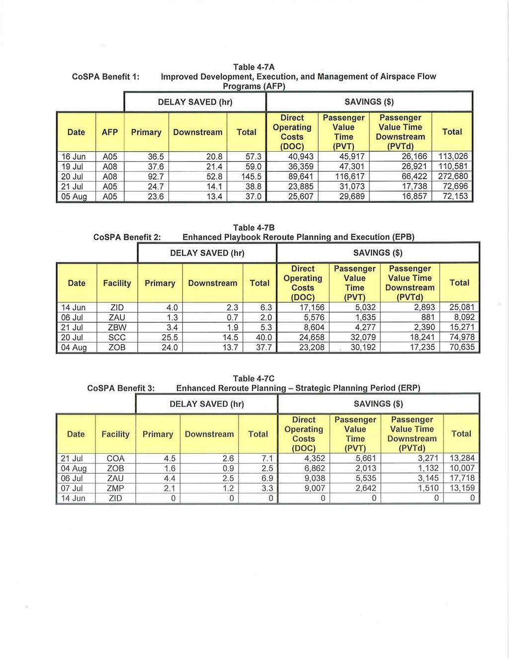
20 4.3 COSPA Delay Savings Case Studies Case studies of observed CoSPA operational usage were analyzed to estimate the delay savings associated with the three primary strategic planning benefits categories - AFP, EPB, and ERP. To prevent double-counting, care was taken when categorizing CoSPA usage observations to ensure that one primary benefit category was assigned to each documented application (e.g., if a strategic rerouting application was categorized as EPB, then it could not also be categorized as ERP -and vice versa). A total of 15 CoSPA benefits cases were analyzed - 5 cases for each primary benefits category. Cases were arbitrarily selected in a manner that allowed us to sample beneficial decisions and examine potential delay reduction benefits across as many different facilities and airspace regions as possible. A summary of case study results from one AFP, EPB, and ERP decision derived from CoSPA is presented in Tables , respectively. T a bl e 4-4 S ummary o f C 0 SPA B ene ft 1 s C ase St u d Jy f or mprove d AFP D ec1s1on-.. M a k' mg Date: 19 July 2010 Facilities Using CoSPA: zoe CoSPA Application: Upon reaching decision to implement AFP A08, ZDC used CoSPA 3-5 hr precipitation forecasts- predicting minimal Northeast convective weather development prior to 1900 UTC - to convince ATCSCC to start AFP at 1900 UTC rather than 1700 UTC. Alternative Decision: Without CoSPA, AFP A081ikely would have started at 1700 UTC; 1300 UTC 4 hr CCFP predicted low confidence, low coverage polygon through central zoe at 1700 UTC - historically, this type of CCFP forecast has proven sufficient justification for A08 implementation. Benefit Period: UTC (2.0 hr) CoSPA Delay Savings Calculations: A08 Program: UTC (issued 1445 UTC) Rate: 90 flights/hr Avg Delay: 16 min Total flights departing for primary A08 airports between UTC AND crossing A08 boundary that would have received AFP EDCTs, averaging 16 min delay: 141 Primary delay reduction for 141 departures avoiding 16 min AFP delay: Downstream Delay Reduction: Total CoSPA Delay Reduction: 37.6 hr 21.4hr 59.0 hr Direct Operating Cost (DOC) Savings: $36,359 Passenger Value Time (PVT) Savings: $47,301 Downstream Cost Savings (PVT only): $26,921 Total CoSPA Cost Savings: $110,581
21 Table 4-5. Summary of CoSPA Benefits Case Study for Enhanced Playbook Route Management (EPB) Date: 14 June 2010 Facilities Using CoSPA: ZID CoSPA Application: ZID used CoSPA precipitation forecast (as additional information to augment CCFP) to determine that an eastward moving cluster of storms was predicted to hold together and impact ORO arrivals through ZID airspace. Based on CoSPA, ZID proactively collaborates on a Playbook reroute plan- "ORO-East-Arrivals" modified Playbook route implemented UTC- allowing a single stream of ORO arrival traffic through ZID airspace Alternative Decision: Without CoSPA, ZID likely would not have readily anticipated the functional gaps in forecast weather within the large, high-confidence CCFP forecast region. In turn, single stream ORO arrival flows over MZZJFWA (part of modified Playbook routing) likely would have instead routed further west to the FAM fix or further north via FWA (rather than using MZZ) Benefit Period: UTC (2.9 hr) CoSPA Delay Savings Calculations: Number of ORO arrival flights, departing during benefits period, utilizing MZZ or FWA leg of Playbook routing: 12 Total flight distance saved: 1450 mi Primary delay reduction: Downstream Delay Reduction: Total CoSPA Delay Reduction: 4.0 hr 2.3 hr 6.3 hr Direct Operating Cost (DOC) Savings: $17,156 Passenger Value Time (PVT) Savings: $5,032 Downstream Cost Savings (PVT only): $2,893 Total CoSPA Cost Savings: $25,081
22
23

24

25

26
27 Symposium on Weather - Air Traffic Management Integration, AMS, Seattle, WA. Phillips, C., J. Pinto, D. Albo, and M. Steiner, 2010: Diagnosis of Phase Errors in High Resolution NWP Model Forecasts of Precipitation and Application of Improved Aviation Weather Forecasts, 14th Conference on Aviation, Range, and Aerospace Meteorology, AMS, Atlanta, GA. Conference on Aviation, Range, and Aerospace Meteorology, AMS, Atlanta, GA. Wolfson, M. M., Dupree, W. J., Rasmussen, R., Steiner, M., Benjamin, S., Weygandt, S., 2008: Consolidated Storm Prediction for Aviation (CoSPA), 13th Conference on Aviation, Range, and Aerospace Meteorology (ARAM), New Orleans, LA, Amer. Meteor. Soc. Pinto, J., J. Williams, M. Steiner, D. Albo, S. Dettling, W. Dupree, D. Morse, H. lskenderian, T. Xiaofeng, M. Wolfson, C. Reiche, S. Weygandt, S. Benjamin, and C. Alexander, 2010: Advances in the Collaborative Storm Prediction for Aviation (CoSPA), 14th Conference on Aviation, Range, and Aerospace Meteorology, AMS, Atlanta, GA. Robinson, M. and J. Evans, 2011 : An Interactive Training Approach to Support the Operational Use of Air Traffic Management Convective Weather Decision Support Tools, 2"d Aviation, Range, and Aerospace Meteorology Special Symposium on Weather - Air Traffic Management Integration, AMS, Seattle, WA. Robinson, M., R. Delaura, and N. Underhill, 2009: The Route Availability Planning Tool (RAPT): Evaluation of Departure management Decision Support in New York During the 2009 Convective Weather Season, 8th USNEurope Air Traffic Management Research and Development Seminar (ATM 2009}, Napa, CA. Robinson, M., R. Delaura, J. Evans, and S. McGettigan, 2008: Operational Usage of the Route Availability Planning Tool during the 2007 Convective Weather Season, MIT Lincoln Laboratory Project Report ATC-339. Robinson, M., J. Evans, B. Crowe, D. Klingle Wilson and S. Allan, 2004: CIWS Operational Benefits : Initial Estimates of Convective Weather Delay Reduction, MIT Lincoln Laboratory Project Report ATC-313. Weiman, S., A Williams, and D. Hechtman, 2010: Calculating Delay Propagation Multipliers for Cost Benefit Analysis, MITRE Report. Weygandt, S., T. Smirnova, C., Alexander, S. Benjamin, K. Brundage, B. Jamison, and S. Sahm, 2010: The High Resolution Rapid Refresh (HRRR): Recent Enhancements and Evaluation During the 2009 Convective Season, 14th
Forecast Confidence. Haig Iskenderian. 18 November Sponsor: Randy Bass, FAA Aviation Weather Research Program, ANG-C6
 Forecast Confidence Haig Iskenderian 18 November 2014 Sponsor: Randy Bass, FAA Aviation Weather Research Program, ANG-C6 Distribution Statement A. Approved for public release; distribution is unlimited.
Progress in Aviation Weather Forecasting for ATM Decision Making FPAW 2010
 Progress in Aviation Weather Forecasting for ATM Decision Making FPAW 2010 Jim Evans Marilyn Wolfson 21 October 2010-1 Overview (1) Integration with storm avoidance models and ATC route usage models (2)
INTEGRATING IMPROVED WEATHER FORECAST DATA WITH TFM DECISION SUPPORT SYSTEMS Joseph Hollenberg, Mark Huberdeau and Mike Klinker
 INTEGRATING IMPROVED WEATHER FORECAST DATA WITH TFM DECISION SUPPORT SYSTEMS Joseph Hollenberg, Mark Huberdeau and Mike Klinker The MITRE Corporation Center for Advanced Aviation System Development (CAASD)
Corridor Integrated Weather System (CIWS) MIT Lincoln Laboratory. CIWS D. Meyer 10/21/05
 MIT Lincoln Laboratory. CIWS D. Meyer 10/21/05") Corridor Integrated Weather System () Outline Example of Weather Impacting Air traffic Impacts on worst delay day Ways to reduce delay Improve forecasts Aid traffic flow management Aviation Delay Problem
Corridor Integrated Weather System () Outline Example of Weather Impacting Air traffic Impacts on worst delay day Ways to reduce delay Improve forecasts Aid traffic flow management Aviation Delay Problem
Traffic Flow Impact (TFI)
") Traffic Flow Impact (TFI) Michael P. Matthews 27 October 2015 Sponsor: Yong Li, FAA ATO AJV-73 Technical Analysis & Operational Requirements Distribution Statement A. Approved for public release; distribution
Traffic Flow Impact (TFI) Michael P. Matthews 27 October 2015 Sponsor: Yong Li, FAA ATO AJV-73 Technical Analysis & Operational Requirements Distribution Statement A. Approved for public release; distribution
Weather Evaluation Team (WET)
") Weather Evaluation Team (WET) Presented to: Friends and Partners in Aviation Weather Kevin Johnston ATCSCC Tom Fahey Delta Air Lines 1 WET Membership FAA Denver ARTCC Atlanta ARTCC ATCSCC Minneapolis TRACON
Weather Evaluation Team (WET) Presented to: Friends and Partners in Aviation Weather Kevin Johnston ATCSCC Tom Fahey Delta Air Lines 1 WET Membership FAA Denver ARTCC Atlanta ARTCC ATCSCC Minneapolis TRACON
Weather Forecast Guidance and Impact on NAS Management August 3, 2016
 Friends and Partners of Aviation Weather Summer 2016 Meeting Weather Forecast Guidance and Impact on NAS Management August 3, 2016 Jim Enders and Kevin Johnston FAA Air Traffic Organization INTRODUCTION
EVALUATING AIR TRAFFIC MANAGEMENT (ATM) BENEFITS OF ENHANCED AVIATION WEATHER DECISION SUPPORT USING A WEATHER-AWARE NATIONAL AIRSPACE SIMULATOR
 BENEFITS OF ENHANCED AVIATION WEATHER DECISION SUPPORT USING A WEATHER-AWARE NATIONAL AIRSPACE SIMULATOR") EVALUATING AIR TRAFFIC MANAGEMENT (ATM) BENEFITS OF ENHANCED AVIATION WEATHER DECISION SUPPORT USING A WEATHER-AWARE NATIONAL AIRSPACE SIMULATOR Michael Robinson* AvMet Applications Inc., Reston, VA Alexander
EVALUATING AIR TRAFFIC MANAGEMENT (ATM) BENEFITS OF ENHANCED AVIATION WEATHER DECISION SUPPORT USING A WEATHER-AWARE NATIONAL AIRSPACE SIMULATOR Michael Robinson* AvMet Applications Inc., Reston, VA Alexander
Update on CoSPA Storm Forecasts
 Update on CoSPA Storm Forecasts Haig August 2, 2011 This work was sponsored by the Federal Aviation Administration under Air Force Contract No. FA8721-05-C-0002. Opinions, interpretations, conclusions,
(2016) MASSACHUSETTS INSTITUTE OF TECHNOLOGY
 MASSACHUSETTS INSTITUTE OF TECHNOLOGY") This document is disseminated under the sponsorship of the Department of Transportation, Federal Aviation Administration (FAA), in the interest of information exchange. The United States Government assumes
This document is disseminated under the sponsorship of the Department of Transportation, Federal Aviation Administration (FAA), in the interest of information exchange. The United States Government assumes
ESTIMATING THE LIKELIHOOD OF SUCCESS IN DEPARTURE MANAGEMENT STRATEGIES DURING CONVECTIVE WEATHER
 ESTIMATING THE LIKELIHOOD OF SUCCESS IN DEPARTURE MANAGEMENT STRATEGIES DURING CONVECTIVE WEATHER Rich DeLaura, Ngaire Underhill, and Yari Rodriguez MIT Lincoln Laboratory, Lexington, Massachusetts Abstract
Weather Integration for Strategic Traffic Flow Management
 The MITRE Corporation s Center for Advanced Aviation System Development Approved for Public Release; Distribution Unlimited. 15-3356 Weather Integration for Strategic Traffic Flow Management Dr. Christine
Improvement of Mesoscale Numerical Weather Prediction For Coastal Regions of Complex Terrain FY2003
 Improvement of Mesoscale Numerical Weather Prediction For Coastal Regions of Complex Terrain FY2003 Clifford F. Mass Department of Atmospheric Sciences Box 351640 University of Washington Seattle, Washington
Corridor Integrated Weather System Operational Benefits : Initial Estimates of Convective Weather Delay Reduction
 Report No. DOT/FAA/RD-95/5 Project Report ATC-313 Corridor Integrated Weather System Operational Benefits 2002 2003: Initial Estimates of Convective Weather Delay Reduction M. Robinson J. Evans B. Crowe
Practical Applications of Probability in Aviation Decision Making
 Practical Applications of Probability in Aviation Decision Making Haig 22 October 2014 Portfolio of TFM Decisions Playbook Reroutes Ground Stops Ground Delay Programs Airspace Flow Programs Arrival & Departure
2017 MASSACHUSETTS INSTITUTE OF TECHNOLOGY
 This material is based upon work supported by the Federal Aviation Administration (FAA) under Air Force Contract No. FA8721-05-C-0002 and/or FA8702-15-D-0001. Any opinions, findings, conclusions or recommendations
Implementing Relevant Performance Measures for Traffic Flow Management
 Implementing Relevant Performance Measures for Traffic Flow Management Friends/Partners of Aviation Weather Forum October 11, 2011 Las Vegas, Nevada Cyndie Abelman NOAA/NWS Aviation Services Baseline of
Operational Usage of the Route Availability Planning Tool During the 2007 Convective Weather Season. Lincoln Laboratory
 Project Report ATC-339 Operational Usage of the Route Availability Planning Tool During the 2007 Convective Weather Season M. Robinson R. A. DeLaura J. E. Evans S. McGettigan (FAA) 13 August 2008 Lincoln
Blend of UKMET and GFS 3hr increments F06 to F degree downloadable grid available on WIFS
 Blend of UKMET and GFS 3hr increments F06 to F36 1.25 degree downloadable grid available on WIFS WWW.AVIATIONWEATHER.GOV/WAFS Wind, Turbulence and Cb 2 3 New Products: All diagnostics mapped to Eddy Dissipation
Translating Meteorological Observations into Air Traffic Impacts in Singapore Flight Information Region (FIR)
") Translating Meteorological Observations into Air Traffic Impacts in Singapore Flight Information Region (FIR) Michael Robinson The MITRE Corporation Approved for Public Release; Distribution Unlimited.
Translating Meteorological Observations into Air Traffic Impacts in Singapore Flight Information Region (FIR) Michael Robinson The MITRE Corporation Approved for Public Release; Distribution Unlimited.
Using Ensemble Forecasts to Support NAS Strategic Planning
 Center for Advanced Aviation System Development Using Ensemble Forecasts to Support NAS Strategic Planning Alex Tien, Christine Taylor, Craig Wanke Friends and Partners in Aviation Weather Forum NBAA Business
Traffic Flow Management (TFM) Weather Rerouting Decision Support. Stephen Zobell, Celesta Ball, and Joseph Sherry MITRE/CAASD, McLean, Virginia
 Weather Rerouting Decision Support. Stephen Zobell, Celesta Ball, and Joseph Sherry MITRE/CAASD, McLean, Virginia") Traffic Flow Management (TFM) Weather Rerouting Decision Support Stephen Zobell, Celesta Ball, and Joseph Sherry MITRE/CAASD, McLean, Virginia Stephen Zobell, Celesta Ball, and Joseph Sherry are Technical
Traffic Flow Management (TFM) Weather Rerouting Decision Support Stephen Zobell, Celesta Ball, and Joseph Sherry MITRE/CAASD, McLean, Virginia Stephen Zobell, Celesta Ball, and Joseph Sherry are Technical
2.3 QUANTIFYING DELAY REDUCTION BENEFITS FOR AVIATION CONVECTIVE WEATHER DECISION SUPPORT SYSTEMS*
 Proceedings of the 11 th Conference on Aviation, Range and Aerospace Meteorology, Hyannis, MA 24 2.3 QUANTIFYING DELAY REDUCTION BENEFITS FOR AVIATION CONVECTIVE WEATHER DECISION SUPPORT SYSTEMS* James
INITIAL STUDIES OF AN OBJECTIVE MODEL TO FORECAST ACHIEVABLE AIRSPACE FLOW PROGRAM THROUGHPUT FROM CURRENT AND FORECAST WEATHER INFORMATION*
 INITIAL STUDIES OF AN OBJECTIVE MODEL TO FORECAST ACHIEVABLE AIRSPACE FLOW PROGRAM THROUGHPUT FROM CURRENT AND FORECAST WEATHER INFORMATION* 1. INTRODUCTION Michael Robinson, Rich DeLaura, Brian D. Martin,
2001 The MITRE Corporation. ALL RIGHTS RESERVED.
 TRAFFIC FLOW MANAGEMENT (TFM) WEATHER REROUTING Joseph E. Sherry*, C.G. Ball, S.M. Zobell The MITRE Corporation, Center for Advanced Aviation System Development (CAASD), McLean, Virginia This work was
Montréal, 7 to 18 July 2014
 INTERNATIONAL CIVIL AVIATION ORGANIZATION WORLD METEOROLOGICAL ORGANIZATION MET/14-WP/34 28/5/14 Meteorology (MET) Divisional Meeting (2014) Commission for Aeronautical Meteorology Fifteenth Session Montréal,
J11.3 Aviation service enhancements across the National Weather Service Central Region
 J11.3 Aviation service enhancements across the National Weather Service Central Region Brian P. Walawender * National Weather Service Central Region HQ, Kansas City, MO Jennifer A. Zeltwanger National
Comparative Analysis of Flood Routing Methods
 US Army Corps of Engineers Hydrologic Engineering Center Comparative Analysis of Flood Routing Methods September 1980 Approved for Public Release. Distribution Unlimited. RD-24 REPORT DOCUMENTATION PAGE
An Operational Evaluation of the Ground Delay Program (GDP) Parameters Selection Model (GPSM)
 Parameters Selection Model (GPSM)") An Operational Evaluation of the Ground Delay Program (GDP) Parameters Selection Model (GPSM) Lara Shisler, Christopher Provan Mosaic ATM Dave Clark MIT Lincoln Lab William Chan, Shon Grabbe NASA Ames
An Operational Evaluation of the Ground Delay Program (GDP) Parameters Selection Model (GPSM) Lara Shisler, Christopher Provan Mosaic ATM Dave Clark MIT Lincoln Lab William Chan, Shon Grabbe NASA Ames
DISTRIBUTION STATEMENT A. Approved for public release; distribution is unlimited.
 DISTRIBUTION STATEMENT A. Approved for public release; distribution is unlimited. The Probabilistic Nature of Extended-Range Predictions of Tropical Cyclone Activity and Tracks as a Factor in Forecasts
Predicting Tropical Cyclone Formation and Structure Change
 Predicting Tropical Cyclone Formation and Structure Change Patrick A. Harr Department of Meteorology Naval Postgraduate School Monterey, CA 93943-5114 Telephone: (831)656-3787 FAX:(831)656-3061 email:
Emerging Aviation Weather Research at MIT Lincoln Laboratory*
 Emerging Aviation Weather Research at MIT Lincoln Laboratory* Haig 19 November 2015 *This work was sponsored by the Federal Aviation Administration under Air Force Contract No. FA8721-05-C-0002. Opinions,
NAVGEM Platform Support
 DISTRIBUTION STATEMENT A. Approved for public release; distribution is unlimited. NAVGEM Platform Support Mr. Timothy Whitcomb Naval Research Laboratory 7 Grace Hopper Ave, MS2 Monterey, CA 93943 phone:
Motivation for Operational Bridging and the Aviation Weather Statement
 Motivation for Operational Bridging and the Aviation Weather Statement Weather Evaluation Team Presentation Friends and Partners of Aviation Weather October 23, 2013 Octoberr June 2013 2013 Operational
National Convective Weather Forecasts Cindy Mueller
 National Convective Weather Forecasts Cindy Mueller National Center for Atmospheric Research Research Applications Program National Forecast Demonstration 2-4-6 hr Convection Forecasts Collaborative forecast
High Resolution Surface Characterization from Marine Radar Measurements
 DISTRIBUTION STATEMENT A: Distribution approved for public release; distribution is unlimited High Resolution Surface Characterization from Marine Radar Measurements Hans C. Graber CSTARS - University
Deferability: A Concept for Incremental Air Traffic Management Decision Making
 Deferability: A Concept for Incremental Air Traffic Management Decision Making Stephen Zobell 1 and Craig Wanke 2 The MITRE Corporation, McLean, VA, 22102 Dealing with uncertainty poses a challenge for
REGENERATION OF SPENT ADSORBENTS USING ADVANCED OXIDATION (PREPRINT)
") AL/EQ-TP-1993-0307 REGENERATION OF SPENT ADSORBENTS USING ADVANCED OXIDATION (PREPRINT) John T. Mourand, John C. Crittenden, David W. Hand, David L. Perram, Sawang Notthakun Department of Chemical Engineering
AL/EQ-TP-1993-0307 REGENERATION OF SPENT ADSORBENTS USING ADVANCED OXIDATION (PREPRINT) John T. Mourand, John C. Crittenden, David W. Hand, David L. Perram, Sawang Notthakun Department of Chemical Engineering
Extended TFM Coordination Through Collaborative Planning
 Extended TFM Coordination Through Collaborative Planning (Improvements to the Collaborative Planning Process) NBAA 64 th Annual Meeting and Convention Friends and Partners in Aviation Weather October 11
Amy Harless. Jason Levit, David Bright, Clinton Wallace, Bob Maxson. Aviation Weather Center Kansas City, MO
 Amy Harless Jason Levit, David Bright, Clinton Wallace, Bob Maxson Aviation Weather Center Kansas City, MO AWC Mission Decision Support for Traffic Flow Management Ensemble Applications at AWC Testbed
Synthetic Weather Radar: Offshore Precipitation Capability
 Synthetic Weather Radar: Offshore Precipitation Capability Mark S. Veillette 5 December 2017 Sponsors: Randy Bass, FAA ANG-C6 and Rogan Flowers, FAA AJM-33 DISTRIBUTION STATEMENT A: Approved for public
Coastal Engineering Technical Note
 Coastal Engineering Technical Note CETN I-48 (12/91) Evaluation and Application of the Wave Information Study for the Gulf of Mexico INTRODUCTION The Wave Information Study (WIS) for the Gulf of Mexico
Hurricane Wave Topography and Directional Wave Spectra in Near Real-Time
 Hurricane Wave Topography and Directional Wave Spectra in Near Real-Time Edward J. Walsh NASA/Goddard Space Flight Center, Code 972 Wallops Flight Facility, Wallops Island, VA 23337 phone: (303) 497-6357
Isolating and Assessing Weather-related Air Traffic Delays. A closer-look at what makes this so difficult... Mike Robinson AvMet Applications, Inc.
 Isolating and Assessing Weather-related Air Traffic Delays A closer-look at what makes this so difficult... Mike Robinson AvMet Applications, Inc. Is this me? 1 What is a Weather Delay? (It depends on
WMO Aeronautical Meteorology Scientific Conference 2017
 Session 2 Integration, use cases, fitness for purpose and service delivery 2.2 Terminal Area and Impact-based forecast Translating Meteorological Observations into Air Traffic Impacts in Singapore FIR
USER S GUIDE. ESTCP Project ER
 USER S GUIDE Demonstration of a Fractured Rock Geophysical Toolbox (FRGT) for Characterization and Monitoring of DNAPL Biodegradation in Fractured Rock Aquifers ESTCP Project ER-201118 JANUARY 2016 F.D.
1.6 A RESPONSE TO HAZARDOUS WEATHER: INTEGRATE WEATHER INFORMATION INTO TRAFFIC FLOW MANAGEMENT
 1.6 A RESPONSE TO HAZARDOUS WEATHER: INTEGRATE WEATHER INFORMATION INTO TRAFFIC FLOW MANAGEMENT Debbie Johannes*, Dave Rodenhuis FAA, ATO, System Operations Services, Herndon, VA Mark Huberdeau MITRE CAASD,
Weather Products for Decision Support Tools Joe Sherry April 10, 2001
 Weather Products for Decision Support Tools Joe Sherry National Convective Weather Forecast (NCWF) Computer generated graphical forecast extending 0-1 hours, updated every 5 minutes Conservative forecast
Estimation of Vertical Distributions of Water Vapor and Aerosols from Spaceborne Observations of Scattered Sunlight
 Estimation of Vertical Distributions of Water Vapor and Aerosols from Spaceborne Observations of Scattered Sunlight Dale P. Winebrenner Polar Science Center/Applied Physics Laboratory University of Washington
Tactical Weather Decision Support To Complement Strategic Traffic Flow Management for Convective Weather *
 4 th USA/Europe Air Traffic Management R&D Seminar Santa Fe, New Mexico 3-7 December 2001 Tactical Weather Decision Support To Complement Strategic Traffic Flow Management for Convective Weather * Dr.
PIPS 3.0. Pamela G. Posey NRL Code 7322 Stennis Space Center, MS Phone: Fax:
 PIPS 3.0 Ruth H. Preller Naval Research Laboratory, Code 7322 Stennis Space Center, MS 39529 phone: (228) 688-5444 fax: (228)688-4759 email: preller@nrlssc.navy.mil Pamela G. Posey NRL Code 7322 Stennis
System Reliability Simulation and Optimization by Component Reliability Allocation
 System Reliability Simulation and Optimization by Component Reliability Allocation Zissimos P. Mourelatos Professor and Head Mechanical Engineering Department Oakland University Rochester MI 48309 Report
EXPLORATION OF A MODEL RELATING ROUTE AVAILABILITY IN EN ROUTE AIRSPACE TO ACTUAL WEATHER COVERAGE PARAMETERS
 Page 1 of 13 P12.7 EXPLORATION OF A MODEL RELATING ROUTE AVAILABILITY IN EN ROUTE AIRSPACE TO ACTUAL WEATHER COVERAGE PARAMETERS Brian D. Martin*, James Evans, and Richard DeLaura MIT Lincoln Laboratory
Analytical Workload Model for Estimating En Route Sector Capacity in Convective Weather*
 Analytical Workload Model for Estimating En Route Sector Capacity in Convective Weather* John Cho, Jerry Welch, and Ngaire Underhill 16 June 2011 Paper 33-1 *This work was sponsored by the Federal Aviation
Jarrod Lichty, R. S. Lee, and S. Percic AvMet Applications, Inc., Reston, Va.
 642 Impact-Based Aviation Forecast Verification Jarrod Lichty, R. S. Lee, and S. Percic AvMet Applications, Inc., Reston, Va. 1 INTRODUCTION The evaluation of weather forecast quality, as related to air
CRS Report for Congress
 CRS Report for Congress Received through the CRS Web Order Code RS21396 Updated May 26, 2006 Summary Iraq: Map Sources Hannah Fischer Information Research Specialist Knowledge Services Group This report
Probabilistic TFM: Preliminary Benefits Analysis of an Incremental Solution Approach
 Probabilistic TFM: Preliminary Benefits Analysis of an Incremental Solution Approach James DeArmon, Craig Wanke, Daniel Greenbaum MITRE/CAASD 7525 Colshire Dr McLean VA 22102 Introduction The National
Use of Wijsman's Theorem for the Ratio of Maximal Invariant Densities in Signal Detection Applications
 Use of Wijsman's Theorem for the Ratio of Maximal Invariant Densities in Signal Detection Applications Joseph R. Gabriel Naval Undersea Warfare Center Newport, Rl 02841 Steven M. Kay University of Rhode
Attribution Concepts for Sub-meter Resolution Ground Physics Models
 Attribution Concepts for Sub-meter Resolution Ground Physics Models 76 th MORS Symposium US Coast Guard Academy Approved for public release distribution. 2 Report Documentation Page Form Approved OMB No.
Predictive Model for Archaeological Resources. Marine Corps Base Quantico, Virginia John Haynes Jesse Bellavance
 Predictive Model for Archaeological Resources Marine Corps Base Quantico, Virginia John Haynes Jesse Bellavance Report Documentation Page Form Approved OMB No. 0704-0188 Public reporting burden for the
A Methodology and Results for Comparative Assessment of the Prediction Performance of the Collaborative Routing Coordination Tools (CRCT)
") Abstract A Methodology and Results for Comparative Assessment of the Prediction Performance of the Collaborative Routing Coordination Tools (CRCT) Kenneth S. Lindsay The MITRE Corporation Center for Advanced
Abstract A Methodology and Results for Comparative Assessment of the Prediction Performance of the Collaborative Routing Coordination Tools (CRCT) Kenneth S. Lindsay The MITRE Corporation Center for Advanced
Marilyn Wolfson, Convective PDT lead Roy Rasmussen, Convective PDT Alternate lead FPAW meeting, 19 Oct 2006 Orlando. Convective Weather PDT
 Convective Weather Issues Marilyn Wolfson, Convective PDT lead Roy Rasmussen, Convective PDT Alternate lead FPAW meeting, 19 Oct 2006 Orlando Examples of Aviation Storm Forecasts Main issue: Large number
7. PERFORMING ORGANIZATION NAME(S) AND ADDRESS(ES) 8. PERFORMING ORGANIZATION REPORT NUMBER
 AND ADDRESS(ES) 8. PERFORMING ORGANIZATION REPORT NUMBER") REPORT DOCUMENTATION PAGE Form Approved OMB No. 0704-0188 The public reporting burden for this collection of information is estimated to average 1 hour per response, including the time for reviewing instructions,
REPORT DOCUMENTATION PAGE Form Approved OMB No. 0704-0188 The public reporting burden for this collection of information is estimated to average 1 hour per response, including the time for reviewing instructions,
Closed-form and Numerical Reverberation and Propagation: Inclusion of Convergence Effects
 DISTRIBUTION STATEMENT A. Approved for public release; distribution is unlimited. Closed-form and Numerical Reverberation and Propagation: Inclusion of Convergence Effects Chris Harrison Centre for Marine
Consolidated Storm Prediction for Aviation (CoSPA) Overview
 Overview") Consolidated Storm Prediction for Aviation (CoSPA) Overview Ray Moy (FAA), Bill Dupree (MIT LL Lead), and Matthias Steiner (NCAR Lead) 27 September 2007 NBAA User Panel Review - 1 Consolidated Storm Prediction
Consolidated Storm Prediction for Aviation (CoSPA) Overview Ray Moy (FAA), Bill Dupree (MIT LL Lead), and Matthias Steiner (NCAR Lead) 27 September 2007 NBAA User Panel Review - 1 Consolidated Storm Prediction
Evolution of Tropical Cyclone Characteristics
 Evolution of Tropical Cyclone Characteristics Patrick A. Harr Department of Meteorology Naval Postgraduate School Monterey, CA 93943-5114 Telephone : (831) 656-3787 FAX: (831) 656-3061 email: paharr@nps.navy.mil
Cross-cutting Issues Impacting Operational ATM and Cockpit Usability of Aviation Weather Technology. John McCarthy Sherrie Callon Nick Stoer
 Cross-cutting Issues Impacting Operational ATM and Cockpit Usability of Aviation Weather Technology John McCarthy Sherrie Callon Nick Stoer Introduction Air Traffic Management Coordinators are supposed
Report Documentation Page
 Report Documentation Page Form Approved OMB No. 0704-0188 Public reporting burden for the collection of information is estimated to average 1 hour per response, including the time for reviewing instructions,
Convection and Shear Flow in TC Development and Intensification
 DISTRIBUTION STATEMENT A. Approved for public release; distribution is unlimited. Convection and Shear Flow in TC Development and Intensification C.-P. Chang Department of Meteorology Naval Postgraduate
Montréal, 7 to 18 July 2014
 INTERNATIONAL CIVIL AVIATION ORGANIZATION WORLD METEOROLOGICAL ORGANIZATION 6/5/14 Meteorology (MET) Divisional Meeting (2014) Commission for Aeronautical Meteorology Fifteenth Session Montréal, 7 to 18
A report (dated September 20, 2011) on. scientific research carried out under Grant: FA
 on. scientific research carried out under Grant: FA") A report (dated September 20, 2011) on scientific research carried out under Grant: FA2386-10-1-4150 First-principles determination of thermal properties in nano-structured hexagonal solids with doping
A report (dated September 20, 2011) on scientific research carried out under Grant: FA2386-10-1-4150 First-principles determination of thermal properties in nano-structured hexagonal solids with doping
FRACTAL CONCEPTS AND THE ANALYSIS OF ATMOSPHERIC PROCESSES
 1 FRACTAL CONCEPTS AND THE ANALYSIS OF ATMOSPHERIC PROCESSES Robert L. Street Environmental Fluid Mechanics Laboratory Department of Civil Engineering Stanford University Stanford, CA 94305-4020 650-723-4969;
3.2 ADVANCED TERMINAL WEATHER PRODUCTS DEMONSTRATION IN NEW YORK*
 Proceedings of the 11 th Conference on Aviation, Range and Aerospace Meteorology, Hyannis, MA 2004 3.2 ADVANCED TERMINAL WEATHER PRODUCTS DEMONSTRATION IN NEW YORK* Shawn Allan*, Richard DeLaura, Brian
Regional Stratification and Shear of the Various Streams Feeding the Philippine Straits ESR Component
 Regional Stratification and Shear of the Various Streams Feeding the Philippine Straits ESR Component Amy Ffield Earth & Space Research, 290 Clausland Mountain Road, Upper Grandview, NY 10960-4113 phone:
Winter-Weather Forecast Research
 Winter-Weather Forecast Research Dr. Jennifer Bewley 23 April 2014 AvMet Applications, Inc. 1800 Alexander Bell Dr., Ste. 130 Reston, 1 VA 20191 Number of Hours with Wintry Precipitation November 2013
Aviation Weather Routing Tool: A Decision Aid for Manned/Unmanned Aircraft Routing
 Aviation Weather Routing Tool: A Decision Aid for Manned/Unmanned Aircraft Routing Dr. Richard Shirkey Mr. Terry Jameson Battlefield Environment Division Army Research Laboratory, WSMR rshirkeyn@arl.army.mil
Evaluation of Collaborative Rationing of En Route Resources. Josh Marron, Antonio Abad Bill Hall, Francis Carr, Steve Kolitz 25 Sept 2003
 Evaluation of Collaborative Rationing of En Route Resources Josh Marron, Antonio Abad Bill Hall, Francis Carr, Steve Kolitz 25 Sept 2003 Outline The need for collaborative en route rationing Proposed routing
Enhancing Weather Information with Probability Forecasts. An Information Statement of the American Meteorological Society
 Enhancing Weather Information with Probability Forecasts An Information Statement of the American Meteorological Society (Adopted by AMS Council on 12 May 2008) Bull. Amer. Meteor. Soc., 89 Summary This
INVESTIGATING A NEW GROUND DELAY PROGRAM STRATEGY FOR COPING WITH SFO STRATUS* David A. Clark MIT Lincoln Laboratory, Lexington, Massachusetts
 89 th AMS Annual Meeting ARAM Special Symposium on Weather - Air Traffic Phoenix, AZ / 11-15 January 2009 4.6 INVESTIGATING A NEW GROUND DELAY PROGRAM STRATEGY FOR COPING WITH SFO STRATUS* David A. Clark
EFFECTS OF LOCAL METEOROLOGICAL VARIABILITY ON SURFACE AND SUBSURFACE SEISMIC-ACOUSTIC SIGNALS
 EFFECTS OF LOCAL METEOROLOGICAL VARIABILITY ON SURFACE AND SUBSURFACE SEISMIC-ACOUSTIC SIGNALS Jason R. McKenna and Mihan H. McKenna U.S. Army Engineer Research & Development Center, Vicksburg, MS 39180
Thermo-Kinetic Model of Burning for Polymeric Materials
 Thermo-Kinetic Model of Burning for Polymeric Materials Stanislav I. Stoliarov a, Sean Crowley b, Richard Lyon b a University of Maryland, Fire Protection Engineering, College Park, MD 20742 b FAA W. J.
Sea Ice Model for Marginal Ice Zone
 Sea Ice Model for Marginal Ice Zone Max D. Coon Northwest Research Associates, Inc. 14508 N.E. 20 th Street Bellevue, WA 98007-3713 Phone: (425) 644-9660 ext. 332 Fax: (425) 644-8422 E-mail: max@nwra.com
Assimilation of Synthetic-Aperture Radar Data into Navy Wave Prediction Models
 Assimilation of Synthetic-Aperture Radar Data into Navy Wave Prediction Models David T. Walker Earth Sciences Group, Veridian ERIM International P.O. Box 134008, Ann Arbor, MI 48113-4008 phone: (734)994-1200
Topographic Effects on Stratified Flows
 Topographic Effects on Stratified Flows Laurence Armi Institute of Geophysics and Planetary Physics Scripps Institution of Oceanography La Jolla, CA 92093-0225 phone: (858) 534-6843 fax: (858) 534-5332
Optimizing Robotic Team Performance with Probabilistic Model Checking
 Optimizing Robotic Team Performance with Probabilistic Model Checking Software Engineering Institute Carnegie Mellon University Pittsburgh, PA 15213 Sagar Chaki, Joseph Giampapa, David Kyle (presenting),
Coastal Ocean Circulation Experiment off Senegal (COCES)
") DISTRIBUTION STATEMENT A: Approved for public release; distribution is unlimited. Coastal Ocean Circulation Experiment off Senegal (COCES) Pierre-Marie Poulain Istituto Nazionale di Oceanografia e di Geofisica
DISTRIBUTION STATEMENT A: Approved for public release; distribution is unlimited. Coastal Ocean Circulation Experiment off Senegal (COCES) Pierre-Marie Poulain Istituto Nazionale di Oceanografia e di Geofisica
REPORT DOCUMENTATION PAGE
 REPORT DOCUMENTATION PAGE Form Approved OMB No. 0704-0188 The public reporting burden for this collection of information is estimated to average 1 hour per response, including the time for reviewing instructions,
DIRECTIONAL WAVE SPECTRA USING NORMAL SPREADING FUNCTION
 CETN-I-6 3185 DIRECTIONAL WAVE SPECTRA USING NORMAL SPREADING FUNCTION PURPOSE : To present a parameterized model of a directional spectrum of the sea surface using an energy spectrum and a value for the
Nonlinear Internal Waves: Test of the Inverted Echo Sounder
 Nonlinear Internal Waves: Test of the Inverted Echo Sounder David M. Farmer Graduate School of Oceanography (educational) University of Rhode Island Narragansett, RI 02882 Phone: (401) 874-6222 fax (401)
Understanding Near-Surface and In-cloud Turbulent Fluxes in the Coastal Stratocumulus-topped Boundary Layers
 Understanding Near-Surface and In-cloud Turbulent Fluxes in the Coastal Stratocumulus-topped Boundary Layers Qing Wang Meteorology Department, Naval Postgraduate School Monterey, CA 93943 Phone: (831)
Vortex Rossby Waves and Hurricane Evolution in the Presence of Convection and Potential Vorticity and Hurricane Motion
 LONG-TERM GOALS/OBJECTIVES Vortex Rossby Waves and Hurricane Evolution in the Presence of Convection and Potential Vorticity and Hurricane Motion Michael T. Montgomery Department of Atmospheric Science
SW06 Shallow Water Acoustics Experiment Data Analysis
 DISTRIBUTION STATEMENT A: Approved for public release; distribution is unlimited. SW06 Shallow Water Acoustics Experiment Data Analysis James F. Lynch MS #12, Woods Hole Oceanographic Institution Woods
An Examination of 3D Environmental Variability on Broadband Acoustic Propagation Near the Mid-Atlantic Bight
 An Examination of 3D Environmental Variability on Broadband Acoustic Propagation Near the Mid-Atlantic Bight Kevin B. Smith Code PH/Sk, Department of Physics Naval Postgraduate School Monterey, CA 93943
Coastal Mixing and Optics
 Coastal Mixing and Optics W. Scott Pegau College of Oceanic and Atmospheric Sciences Ocean. Admin. Bldg. 104 Oregon State University Corvallis, OR 97331-5503 Phone: (541) 737-5229 fax: (541) 737-2064 email:
Kevin Johnston FAA System Operations Tom Lloyd JetBlue Airways Presented to: AMS New Orleans, LA January 25, 2012
 Traffic Flow Management (TFM): Dealing with the Impact of Weather Through Collaborative Decision Making (CDM) ~ An Overview of the CDM Weather Evaluation Team (WET) s Ongoing Activities Kevin Johnston
Estimation of Vertical Distributions of Water Vapor from Spaceborne Observations of Scattered Sunlight
 Estimation of Vertical Distributions of Water Vapor from Spaceborne Observations of Scattered Sunlight Dale P. Winebrenner Applied Physics Laboratory, Box 355640 University of Washington Seattle, WA 98195
RANGE SUSTAINABILITY GIS APPLICATIONS AND ENTERPRISE IMPLEMENTATIONS
 RANGE SUSTAINABILITY GIS APPLICATIONS AND ENTERPRISE IMPLEMENTATIONS May 4, 2009 Gabe Lovasz, Geospatial Analyst, ManTech SRS Molly Rodriguez, Geospatial Analyst, ManTech SRS -In Support of- The Office
11.2 CLASSIFICATION OF WEATHER TRANSLATION MODELS FOR NEXTGEN
 11.2 CLASSIFICATION OF WEATHER TRANSLATION MODELS FOR NEXTGEN Jimmy Krozel, Ph.D., Rafal Kicinger, Ph.D., and Mark Andrews Metron Aviation, Inc., Dulles, VA, 20166 1. ABSTRACT In past work, we have surveyed
Investigation of the Air-Wave-Sea Interaction Modes Using an Airborne Doppler Wind Lidar: Analyses of the HRDL data taken during DYNAMO
 DISTRIBUTION STATEMENT: Approved for public release, distribution is unlimited. Investigation of the Air-Wave-Sea Interaction Modes Using an Airborne Doppler Wind Lidar: Analyses of the HRDL data taken