P1.5 Impact of Wind derived from Satellite on Ongoing Japanese long-term Reanalysis project (JRA-25)
|
|
|
- Delphia Heath
- 5 years ago
- Views:
Transcription
1 P1.5 Impact of Wind derived from Satellite on Ongoing Japanese long-term Reanalysis project (JRA-25) Ryo Oyama*, Masami Sakamoto, Masami Tokuno, Nozomu Ohkawara, Shinya Kobayashi, Takanori Matsumoto, Hiroshi Koide, Kazutoshi Onogi, Tomoaki Ose Japan Meteorological Agency, Tokyo, Japan 1. Introduction The Japan 25-year reanalysis referred to as JRA-25 constitutes a consistent set of global weather analyses for the years 1979 to 2004, which is under a collaboration project of Japan Meteorological Agency (JMA) and Central Research Institute of Electric Power Industry (CRIEPI). The primary purpose of JRA-25 is to offer the reanalysis data set and consistent real-time objective analysis. This year is the last year of this project. At present, the evaluation and utilization to investigate the past climate and meteorological events are mainly promoted by JRA-25 evaluation group. It is of interest to study how satellite wind data performed together with all other types of data in assimilation systems. Satellite wind data are estimated by identifying and localizing the pattern ( tracer ) in successive geostationary satellites images, that is, Atmospheric Motion Vector (AMV) or Cloud Motion Wind (CMW). The others are derived from the polar orbital satellite measurements: scatterometer of QuikSCAT, and IR image of MODIS. As CMW/AMV data have been generally provided since 1979 in which GARP project was started, they had already used to assimilate in the past re-analysis projects. Kallberg and Uppala (1999) investigated the impacts of SATOB derived from METEOSAT and GOES, and also showed the statistical characteristics of every geostationary satellite winds and overall data in ERA-15 (ECMWF 15 year reanalysis) project. *Corresponding author: Ryo Oyama, Analysis Division of Meteorological Satellite Center, Japan Meteorological Agency, Nakakiyoto Kiyose-shi, Tokyo, ; oyama@met.kishou.go.jp. Impacts of CMW/AMV on other assimilation systems were also investigated by past researches (Tomassini, 1999; Gupta, et al, 2002; Bormann et al). In this paper, we noticed the impact and importance of CMW/AMV on JRA-25, which might be used in large numbers during all period. We report the impacts of CMW/AMV in each atmospheric layer on JRA-25 wind field and other physical values. In addition, we also show the characteristics of GMS-AMV reprocessed by Meteorological Satellite Center (MSC) for JRA-25. The data is one of the major improvements not included in other re-analyses. 2. Assimilation methods of CMW/AMV in JRA-25 JRA-25 s main characteristics are shown below: 1) Model resolution and Analysis method Vertical Resolution is 40 layers with the top level at 0.4 hpa, horizontal spectral triangular-truncation at total wave number 106 (T106; equivalent to about 110km grid size). Assimilation method is 3D-VAR, which had been adopted in JMA s operational system from September to February ) Observation data used in JRA-25 The data used to assimilate in JRA-25 are conventional data: SYNOP, TEMP, PILOT, AIREP, CMW/AMV and so forth, and satellite remote sensing data: sounder data of TOVS and ATOVS, and sea temperature and sea ice data from SSM/I. CMW/AMV data are used throughout the entire period of JRA-25. METEOSAT wind products between 1982 and 1988 were reproduced by the new algorithm using the recalibrated images of METEOSAT-2 and 3 (Van de berg, L., et al, 2001). Moreover, these have been made as BUFR including QI information since 1
2 September AMV derived from GMS were reproduced by a MSC new operational algorithm (Kumabe, 2004) in the period between April 1987 and May Characteristics of MSC reprocessed AMV MSC of JMA processed High-density Atmospheric Motion Vector (AMV) from GMS-3 to GMS-5 for the period of 1987 to These are processed on the basis of MSC operational AMV extraction method (Kumabe, 2004). Because of defect in the production, the periods when JRA-25 used those products are limited to March December 1993, and January May Main features of GMS AMV are, a) Relatively high Quality Indicators (QI) For each vector of GMS AMV, QI is assigned with the same procedure as the EUMETSAT operational AMV processing (Holmlund, 1997). However, the wind vector extraction procedure itself is MSC in-house, and differs from the EUMETSAT s. Accordingly, for each wind computational method, the distribution of QI is considerably different from EUMETSATs, which have rather constant counts in each division of ranks for all kinds of vectors. IR high winds and WV winds of GMS have peaks on their division of QI magnitude from 81 to 85, IR low and VIS winds tended to have their peak on higher QI divisions. (Fig. 1-1) b) Sparse Mid-level IR Winds Essentially, IR wind vector is processed with two distinctive measures, which are referred as the IR high winds derived from clouds of semi-transparency and the IR low winds derived from opaque clouds generally. At the first step in the MSC IR wind processing technique, IR images are distinguished into 2 levels: above 500hPa and below 850hPa. Consequently, IR vectors at between 500 and 850hPa are rarely produced as shown in Figure 1-2. c) Only GMS-5 has WV winds For the first time of the long records of GMS series observation, GMS-5 launched in Mar 18 in 1995 boarded the imager with WV absorption channel, and it came into operation on June 13 in WV derived winds were also archived from that day to May 2003, when GMS-5 finished its operation. d) Narrower Production Area GMS AMV were processed over the round shaped area bounded 50S and 50N, 90E and 170W (see Fig. 1-3), which was narrower than ones of satellite derived winds of the other operational centers. The high-density winds with quality indicators surely permit free choices of the utilization for NWP centers and reanalysis organizations. But it requires more sophisticated measures for selection, thinning, and evaluation of bias. Because AMVs tend to have inhomogeneous spatial distribution, especially ones with higher QI incline to concentrate narrow areas and are found to have the similar behavior in the small area, which can affect substantially data-assimilation products with the variational techniques 4. Experiments to investigate the impact of CMW and AMV 4.1 Outline of Experiments To investigate impacts of CMW/AMV on JRA-25, in addition to CTRL experiment which includes all CMW/AMW of all satellites, we tried two ones: 1) Experiment without the upper (above 400 hpa level) and 2) without the lower layer (below 700 hpa level). We refer to these as TEST1 and TEST2 respectively (see Table 1). The experiment period is between 00UTC July and 18UTC July In this period, CMW/AMV derived from IR, VS, and WV images of METEOSAT-5 and 7, and GOES-9, 10, and 12 are used. Here, CMW/AMV from GOES-9 is MSC s present improved product explained above. Table1: Configurations of TEST1, TEST2, and CTRL 2
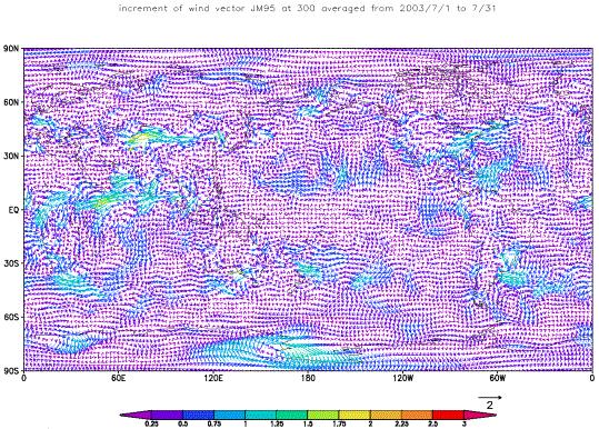
3 4.2 Analysis Impacts on CMW/AMV We show the horizontal distribution of the wind difference (Increment) between the analysis and the first guess of CTRL in Figure 2. Large Increments are found in some part of Antarctic. One of the reasons is conventional data are sparse in the south hemisphere. In upper layer (300 hpa), Increments are larger in Indian Ocean, east coast of North America and southwestern Atlantic Ocean. In the lower layer (850 hpa), they are distinctly larger over Indian Ocean, Tibet Plateau, western America and west of South America. These facts suggest that these regions and levels should be sensitive to the assimilated observational data Impact of Upper layer CMW/AMV Figure 3 and Figure 4 show the monthly averaged difference of zonal wind analyses and forecasted precipitation rate between CTRL and TEST1. We can find out there are some interesting impacts on them, especially, on precipitation rate in the tropics, its feature might closely connect to seasonal oscillation of tropical precipitation. The results of investigations are shown below in detail. (a) Tropical Indian Ocean (30S-30N and 25E-85E: A-1) At hpa levels, the difference of dominant easterly wind speed attains to a speed of 5m/sec or more over Equator-10N and around 55E with use of the upper layer CMW/AMV (see Fig. 5). This result well corresponds to the past research by Tomassini et al (1999) and Bormann et al. Distinct negative Increments of winds are found there (see Fig. 2). In addition, we can find out the impacts on spatial and quantity distribution of precipitation connected to both horizontal circulation and geopotential height fields. According to the vertical cross section of the rotation at 55E of them (as shown in Fig. 6), the use of upper layer CMW/AMV caused the decrease of the rotation at higher than 550 hpa level. As the divergence at hpa levels is weakened over Equator-10N while intensified at hpa levels, a maximum peak of geopotential height is produced at around 400 hpa level. By these impacts, convection is refrained at hpa levels (see Fig. 7). The precipitation rate of CTRL is less than TEST1 by 1.5 to 2.0 mm/hour in the region (shown by blue oval in Fig. 7), while that of CTRL is larger than TEST1 around there (shown by red oval in Fig. 7). In addition, the temperature of CTRL is less than TEST1 by 0.3 degrees or more at hpa levels, and the specific humidity of CTRL is larger than TEST1 only at hpa levels. These might suggest a heating caused by the convection should be restricted to only under about 400 hpa level. Southern middle and high latitudes of Indian Ocean (80S-20S and 10E-70E: A-2) In this region, dominant westerly zonal winds at hpa levels are weakened by 1.5 to 2.0 m/s around 45S with use of upper layer CMW/AMV (Fig. 8-1). On the other hand, the most distinct feature is appears in geopotential height and air temperature fields in spite of the small modification of wind field. The symmetric feature with respect to 45S in the vertical cross section at 40E of temperature and geopotential height is interesting (Fig. 8-2). (c) Western middle and south of Africa (45S-15N and 10W-50E: A-3) It is found that dominant easterlies at hpa levels are intensified by m/s over 10S-10N (see Fig. 9) when upper layer CMW/AMV data are used and negative Increments are found there (see Fig. 2). According to relative humidity, the reduction over 10S to 5N and enlargement over the north and south to there in middle and lower layers well correspond to the divergence and convergence zones there respectively (as not shown here). Such modification of middle and lower wind fields is one of the noticeable 3
4 impacts in the region, which might suggest the relation to African topography. (d) Tropical eastern Pacific Ocean (30S-30N and 150W-90W: A-4) Upper layer CMW/AMV intensified dominant easterlies by m/s at hpa levels (see Fig and 10-2). Here, it is noticeable that large Increments of CTRL is hardly distributed in the level and region. This fact might suggest that upper layer CMW/AMV should well contribute to JRA-25 wind field by the difference of wind between CTRL and TEST1. And, this result partly shows the characteristic of the CMW/AMV derived from GOES-10, which are corrected by the result of numerical model in NESDIS Impact of Lower layer CMW/AMV Figure11 shows the difference of the analyses of physical values between CTRL and TEST2. By and large, lower layer CMW/AMV data tend to modify horizontal circulation field in lower and middle layer. We show the results on every impact below. (a) Tropical eastern Pacific Ocean (30S-30N and 120W-60W:B-1) Figure 12-1 shows that dominant easterlies below 400 hpa level are weakened over 5S to 5N, and intensified over 20S to 5S, when lower layer CMW/AMV are used. As the result, anti-cyclonic circulation in lower layer is intensified over 10S to Equator accompanying with the intensification of the lower layer convergence over Equator to 10N (see Fig. 12-2). This convergence intensification results in the increase of the monthly averaged precipitation rate there as shown in Figure Tropical Indian Ocean (30S-30N and 25E-85E:B-2) At hpa levels, dominant westerly winds around 5N are intensified, and easterlies over 20S to Equator are intensified when lower layer CMW/AMV are used as shown in Figure As the results, anti-cyclonic circulation at hpa levels over 5S to 5N is intensified (see Fig. 13-1). Although such reduction of the precipitation over Equator to 5N as A-1 of TEST1 is confirmed, its change is smaller (see Fig. 13-3). (c) Northeast Pacific Ocean (Equator-60N and 160W-100W:B-3) Below 600 hpa level, cyclonic circulation is intensified over 25N to 35N and at around 125W and anti-cyclonic circulation is intensified over 35N to 45N and at around 135W when lower CMW/AMV are used (see Fig and 14-2 (a)). A heating over 35N to 45N and a cooling over 25N to 35N are characteristic in the lower layer (see Fig ). In spite of these impacts on temperature, the impact on specific humidity is small. It might be one of the reasons that the water vapor is smaller relative to that in the tropics. 5. Statistical feature of impact for each region and satellite To show the statistical feature of the impacts of the CMW/AMV for each satellite and latitudinal band, we show differences of monthly average and standard deviation (SD) of Increment between CTRL and TEST1 or TEST2 for each satellite, level and region in Figure 15. In northern and southern hemisphere (referred to as NH and SH), when upper layer CMW/AMV data are used, the negative Increment of the upper layer zonal wind become larger of every satellite region, that is, dominant westerly wind are weakened. Especially, such tendency is prominent in winter hemisphere. The difference of SD of Increment is also large there. In the tropics (referred to as TP), when upper layer CMW/AMV are used, dominant upper layer easterlies are intensified except for at hpa levels over METEOSAT-5 coverage, which includes Indian Ocean. Over GOES-12 coverage: North America, Atlantic Ocean and Southeastern Pacific, easterlies at upper layer are weakened. Over GOES-10 coverage: mainly 4
5 east Pacific Ocean, modification of wind at upper layer is small. About the impact of lower layer CMW/AMV, differences of SD of Increment generally decrease at lower layer in TP and SH of each satellite coverage, when the lower layer CMW/AMV data are used. On GOES-12, it is characteristic that SD of CTRL tends to be larger than that of TEST2 at hpa in SH and TP. In the upper and middle layers, the impacts due to lower layer CMW/AMV are little for every satellite. Figure 16 shows the horizontal distribution of monthly SD of D-value of zonal wind in 5 5 degree grids and at hpa and hpa levels respectively. The results of METEOSAT-5, GOES-10 and 12 are shown, which cover the impact regions in section 4. For every satellite, SD of D-value in upper and lower layers generally tend to be less over the sea. Within METEOSAT-5 coverage, it found that SD of D-value at both hpa and hpa levels is larger around A-1 in spite of over the sea. This means that large variability by CMW/AMV data exists there. Within the coverage of GOES-10 and 12, SD of zonal wind over the sea are generally small, although a little large values ( m/s) exist at the edge of their coverage. These facts suggested that the CMW/AMV from GOES-10 and 12 should be in harmony with the JRA-25, that is, assimilation system using 3D-VAR. 6. Summary We could confirm the effectiveness and impact of CMW/AMV data on JRA-25 as shown below: (Upper layer CMW/AMV data) Upper layer westerly winds over the middle and high latitudes are found to be weakened with the use of upper layer CMW/AMV data, especially distinct in the winter hemisphere. In the tropical Indian Ocean, dominant upper layer easterlies are intensified by 5m/s or more, when upper layer CMW/AMV are used and negative Increments of zonal wind is found there. The increase of high pressure at around 400 hpa level because of the modification of divergence fields restrains the deep convection. Over western middle and south of Africa, with use of upper layer CMW/AMV, upper layer easterlies are intensified, and the modification of convergence field at middle and lower layers changed the precipitation field. Over southern middle and high latitudes of Indian Ocean, with use of upper layer CMW/AMV, geopotential height and temperature fields are distinctly changed in upper and middle layers while modification of wind field is small there. In tropical eastern Pacific Ocean, dominant easterlies at middle layer are intensified when upper layer CMW/AMV are data used and small Increments of CTRL are found there. (Lower layer CMW/AMV data) JRA-25 s horizontal circulation fields of the middle and lower layers are generally modified with use of lower layer CMW/AMV data. The precipitation field is changed in the tropics. When lower layer CMW/AMV are used in the tropical eastern Pacific Ocean, precipitation increases there because the lower layer anti-cyclonic circulation is intensified to make stronger lower layer convergence. In tropical Indian Ocean, precipitation decreases there as well as in the case with use of upper layer CMW/AMV because anti-cyclonic circulation at middle and lower layers is intensified. In northeast Pacific Ocean, a pair of cyclonic and anti-cyclonic circulation is intensified in lower layer without distinct impact on precipitation and specific humidity there. It is found that use of lower layer CMW/AMV tends to minimize standard deviation of Increment of wind at lower layer. Acknowledgement We would thank K. Kato and T. Imai of JMA/MSC for their valuable supports and advices. 5
6 References Bormann, Niels and Thepaut, J.: Impact of Atmospheric Motion Vectors from INDOEX on ECMWF analyses and forecast. (Met Office HP satwind_report/satwindinfo.html). Gupta M.Das et al. 2002: Impact of high density atmospheric motion vectors in NCMRWF global data assimilation-forecast system. Proc. of Sixth International Winds Workshop, EUMETSAT, Holmlund, K. 1998: The utilization of statistical properties of satellite-derived atmospheric motion vectors to derive quality indicators, Weather and Forecasting, 13, Kållberg, P., and S. Uppala, 1999: Impact of Cloud Motion Winds in the ECMWF ERA15 Reanalysis. Proc. of Fourth International Winds Workshop, EUMETSAT, Kumabe, R. 2004: Renewal of operational AMV extraction system in JMA. Proc. of Seventh International Winds Workshop, EUMETSAT, Tomassini, M., Kelly, G. and Saunders, R., 1999: Use and Impact of satellite atmospheric motion winds on ECMWF analysis and forecasts. Mon.Wea.Rev., 127, Van de Berg, L., Gustafsson, J and Yildirim, 2001: Reprocessing of atmospheric motion vectors from METEOSAT image data. Proc. of ERA-40 workshop on Re-analysis,

, Brown: IR lower (below 600hPa), Green:")

7 (a) QI distribution of GMS-5 QI distribution of METEOSAT-5 and 7 Figure. 1-1: QI grouped by their magnitude. (a) GMS-5 in July 1997, METEOSAT-5, 7 in July Red: IR high (above 600hPa), Brown: IR lower (below 600hPa), Green: VIS, Blue: WV. Figure 1-2: Vertical distribution of GMS-5 IR winds with QI magnitude at 12UTC 2 Jul Figure 1-3: Horizontal distribution of GMS-5 IR winds with QI magnitude at 12UTC 2 Jul 1997.

8
 (500hPa)")


9 A-1 A-3 A-4 A-3 A-2 (300hPa) (500hPa) (850hPa) Figure 3: Difference (CTRL-TEST1) of zonal wind analysis at 300, 500 and 850hPa.
 of")

10 (a) Figure 4: (a) Monthly average of total precipitation rate (mm/hour) of CTRL, Monthly average of difference of total precipitation rate (CTRL-TEST1).


11 (a) (c) Figure 5: Monthly average of analysis wind (Left), and the difference of monthly averaged analysis wind between CTRL and TEST1 (Right) for region A-1. (a) 300hPa, 500hPa, (c) 850hPa.
. Left: Monthly averaged analysis of CTRL, Right: Difference of analysis (CTRL TEST1).")
12 (a) (10-5 s -1 ) (10-6 s -1 ) (c) (degree) (degree) (d) (gpm) (gpm) Figure 6: Longitudinal vertical cross-sections of each physical values at 55E (for region A-1). Left: Monthly averaged analysis of CTRL, Right: Difference of analysis (CTRL TEST1). (a) Zonal wind, Rotation, (c) Temperature, and (d) Geopotential height.
 of CTRL, and Difference between CTRL and TEST1 for")
13 (a) Figure 7: (a) Monthly averaged precipitation rate (mm/hour) of CTRL, and Difference between CTRL and TEST1 for Region A-1.
 (degree) (degree) (c) (gpm) (gpm) Figure 8-2: Longitudinal vertical cross-sections of each physical values at 40E (for region A-2).")
14 Figure 8-1: Monthly averaged analysis wind at 300hPa of CTRL (Left) and difference of monthly averaged wind at 300hPa between CTRL and TEST1 (Right) for region A-2. (a) (degree) (degree) (c) (gpm) (gpm) Figure 8-2: Longitudinal vertical cross-sections of each physical values at 40E (for region A-2). Left: Monthly averaged analysis of CTRL, Right: Difference of analysis (CTRL TEST1). (a) Zonal wind, Temperature, and (c) Geopotential height.
 for region A-3. (a) 300hPa, 500hPa.")
.")
15 (a) Figure 9-1: Monthly averaged analysis wind of CTRL (Left), and Difference between CTRL and TEST2 (Right) for region A-3. (a) 300hPa, 500hPa. (a) (10-2 kg/kg) (10-2 kg/kg) Figure 9-2: Longitudinal vertical cross-sections of each physical elements at 20E (for region A-3). Left: Monthly averaged analysis of CTRL, Right: Difference of analysis (CTRL TEST1). (a) Zonal wind, Specific humidity.
.")
16 Figure 10-1: Monthly averaged analysis wind at 400hPa of CTRL (Left) and difference of analysis wind at 400hPa between CTRL and TEST1 (Right) for region A-4. Figure 10-2: Longitudinal vertical cross-sections of zonal wind at 120W (for region A-4). Left: Monthly averaged analysis of CTRL, Right: Difference of analysis (CTRL TEST1).
 (500hPa)")


17 B-1 B-2 B-3 (300hPa) (500hPa) (850hPa) Figure 11: Difference (CTRL-TEST2) of zonal wind analysis at 300, 500 and 850hPa.
 for")


18 Figure 12-1: Monthly averaged analysis wind at 700hPa of CTRL (Left) and difference of analysis wind at 700hPa between CTRL and TEST2 (Right) for region B-1. Figure 12-2: Longitudinal vertical cross-sections of zonal wind at 90W (for region B-1). Left: Monthly averaged analysis of CTRL, Right: Difference of analysis (CTRL TEST2). (a) Figure 12-3: (a) Monthly averaged precipitation rate (mm/hour) of CTRL, and Difference between CTRL and TEST2 for Region B-1.
 for region B-2.")
.")
19 Figure 13-1: Monthly averaged analysis wind at 700hPa of CTRL (Left) and difference of analysis wind at 700hPa between CTRL and TEST2 (Right) for region B-2. Figure 13-2: Longitudinal vertical cross-sections of zonal wind at 55E (for region B-2). Left: Monthly averaged analysis of CTRL, Right: Difference of analysis (CTRL TEST2). (a) Figure 13-3: (a) Monthly averaged precipitation rate (mm/hour) of CTRL, and Difference between CTRL and TEST2 in region B-2.
 (degree) (degree) Figure 14-2: Longitudinal vertical cross-sections of each physical value at 130W (for region B-3).")
20 Figure 14-1 Monthly averaged analysis wind at 700hPa of CTRL (Left) and difference between CTRL and TEST2 (Right) for region B-3. (a) (degree) (degree) Figure 14-2: Longitudinal vertical cross-sections of each physical value at 130W (for region B-3). Left: Monthly averaged analysis of CTRL, Right: Difference of analysis between CTRL and TEST2. (a) Zonal wind, Temperature.
21 Difference of Monthly average of Zonal Wind increment (JM95-JM97) Difference 衛星 of ID: (METEO-5) average (METEOSAT-5) Difference of SD of Zonal Wind increment (JM95-JM97) 衛星 ID: (METEO-5) Difference of standard deviation (METEOSAT -5) P (hpa) 面 (hpa) P 面 (a) Difference of Monthly average of Zonal Wind increment (JM95-JM97) Difference 衛星 ID: (GOES-10) of average (GOES-10) Difference of SD of Zonal Wind increment (JM95-JM97) 衛星 ID: (GOES-10) Difference of standard deviation (GOES-10) (hpa) P 面 (hpa) P 面 Difference of Monthly average of Zonal Wind increment (JM95-JM97) Difference 衛星 ID: (GOES-12) of average (GOES-12) Difference of SD of Zonal Wind increment (JM95-JM97) 衛星 ID: (GOES-12) Difference of standard deviation (GOES-12) P (hpa) 面 P (hpa) 面 (c) Figure 15-1: Differences of average (Left) and standard deviation (Right) of Increment of Zonal wind between CTRL and TEST1, which are monthly averaged for each satellite, region and level. (a) METEOSAT-5, GOES-10, (c) GOES-12.
22 Difference of monthly average of Zonal Wind Increment (JM95-JM94) Difference 衛星 of ID: (METEO-5) average (METEOSAT-5) Difference of SD of Zonal Wind Increment (JM95-JM94) 衛星 ID: (METEO-5) Difference of standard deviation (METEOSAT -5) P (hpa) 面 (hpa) P 面 (a) Difference of monthly average of Zonal Wind Increment (JM95-JM94) Difference of average (GOES-10) 衛星 ID: (GOES-10) Difference of SD of Zonal Wind Increment (JM95-JM94) 衛星 ID: (GOES-10) Difference of standard deviation (GOES-10) P (hpa) 面 P (hpa) 面 Difference of monthly average of Zonal Wind Increment (JM95-JM94) Difference 衛星 ID: (GOES-12) of average (GOES-12) Difference of SD of Zonal Wind Increment (JM95-JM94) 衛星 ID: (GOES-12) Difference of standard deviation (GOES-12) (hpa) P 面 P (hpa) 面 (c) Figure 15-2: Differences of average (Left) and standard deviation (Right) of Increment (analysis first-guess) of Zonal wind between CTRL and TEST2, which are monthly averaged for each satellite, region and level. (a) METEOSAT -5, GOES-10, (c) GOES-12.
23 (a) (c) Figure 16: Monthly Standard Deviation of D-Value (Observation first-guess) of Zonal Wind of CTRL at hPa (Left) and hPa (Right). (a) METEOSAT -5, GOES-10, (c)goes-12.
RECENT UPGRADES OF AND ACTIVITIES FOR ATMOSPHERIC MOTION VECTORS AT JMA/MSC
 1 th International Winds Workshop, Tokyo, Japan, - ruary 1 RECENT UPGRADES OF AND ACTIVITIES FOR ATMOSPHERIC MOTION VECTORS AT JMA/MSC Ryo OYAMA Meteorological Satellite Center of Japan Meteorological
Current status and plans of JMA operational wind product
 Current status and plans of JMA operational wind product Kazuki Shimoji Japan Meteorological Agency / Meteorological Satellite Center 3-235, Nakakiyoto, Kiyose, Tokyo, Japan Abstract The Meteorological
STATUS OF JAPANESE METEOROLOGICAL SATELLITES AND RECENT ACTIVITIES OF MSC
 STATUS OF JAPANESE METEOROLOGICAL SATELLITES AND RECENT ACTIVITIES OF MSC Daisaku Uesawa Meteorological Satellite Center, Japan Meteorological Agency Abstract MTSAT-1R is the current operational Japanese
The JRA-55 Reanalysis: quality control and reprocessing of observational data
 The JRA-55 Reanalysis: quality control and reprocessing of observational data Kazutoshi Onogi On behalf of JRA group Japan Meteorological Agency 29 October 2014 EASCOF 1 1. Introduction 1. Introduction
AN OBSERVING SYSTEM EXPERIMENT OF MTSAT RAPID SCAN AMV USING JMA MESO-SCALE OPERATIONAL NWP SYSTEM
 AN OBSERVING SYSTEM EXPERIMENT OF MTSAT RAPID SCAN AMV USING JMA MESO-SCALE OPERATIONAL NWP SYSTEM Koji Yamashita Japan Meteorological Agency / Numerical Prediction Division 1-3-4, Otemachi, Chiyoda-ku,
QUALITY CONTROL OF WINDS FROM METEOSAT 8 AT METEO FRANCE : SOME RESULTS
 QUALITY CONTROL OF WINDS FROM METEOSAT 8 AT METEO FRANCE : SOME RESULTS Christophe Payan Météo France, Centre National de Recherches Météorologiques, Toulouse, France Astract The quality of a 30-days sample
AMVs in the ECMWF system:
 AMVs in the ECMWF system: Overview of the recent operational and research activities Kirsti Salonen and Niels Bormann Slide 1 AMV sample coverage: monitored GOES-15 GOES-13 MET-10 MET-7 MTSAT-2 NOAA-15
RECENT ADVANCES TO EXPERIMENTAL GMS ATMOSPHERIC MOTION VECTOR PROCESSING SYSTEM AT MSC/JMA
 RECENT ADVANCES TO EXPERIMENTAL GMS ATMOSPHERIC MOTION VECTOR PROCESSING SYSTEM AT MSC/JMA Ryoji Kumabe 1, Yoshiki Kajino 1 and Masami Tokuno 2 1 Meteorological Satellite Center, Japan Meteorological Agency
JMA s ATMOSPHERIC MOTION VECTORS In response to Action 40.22
 5 July 2013 Prepared by JMA Agenda Item: II/6 Discussed in WG II JMA s ATMOSPHERIC MOTION VECTORS In response to Action 40.22 This paper reports on the recent status of JMA's AMVs from MTSAT-2 and MTSAT-1R,
Masahiro Kazumori, Takashi Kadowaki Numerical Prediction Division Japan Meteorological Agency
 Development of an all-sky assimilation of microwave imager and sounder radiances for the Japan Meteorological Agency global numerical weather prediction system Masahiro Kazumori, Takashi Kadowaki Numerical
IMPACT STUDIES OF AMVS AND SCATTEROMETER WINDS IN JMA GLOBAL OPERATIONAL NWP SYSTEM
 IMPACT STUDIES OF AMVS AND SCATTEROMETER WINDS IN JMA GLOBAL OPERATIONAL NWP SYSTEM Koji Yamashita Japan Meteorological Agency / Numerical Prediction Division 1-3-4, Otemachi, Chiyoda-ku, Tokyo 100-8122,
Operational Use of Scatterometer Winds at JMA
 Operational Use of Scatterometer Winds at JMA Masaya Takahashi Numerical Prediction Division, Japan Meteorological Agency (JMA) 10 th International Winds Workshop, Tokyo, 26 February 2010 JMA Outline JMA
REPROCESSING OF ATMOSPHERIC MOTION VECTORS FROM METEOSAT IMAGE DATA
 REPROCESSING OF ATMOSPHERIC MOTION VECTORS FROM METEOSAT IMAGE DATA Jörgen Gustafsson, Leo van de Berg, Fausto Roveda, Ahmet Yildirim Meteorological Operations Division, EUMETSAT Am Kavalleriesand 31,
JMA s atmospheric motion vectors
 Prepared by JMA Agenda Item: WG II/6 Discussed in WG II JMA s atmospheric motion vectors This paper reports on the recent status of JMA's Atmospheric Motion Vectors (AMVs) from MTSAT-2 and MTSAT-1R, and
IMPROVEMENTS IN FORECASTS AT THE MET OFFICE THROUGH REDUCED WEIGHTS FOR SATELLITE WINDS. P. Butterworth, S. English, F. Hilton and K.
 IMPROVEMENTS IN FORECASTS AT THE MET OFFICE THROUGH REDUCED WEIGHTS FOR SATELLITE WINDS P. Butterworth, S. English, F. Hilton and K. Whyte Met Office London Road, Bracknell, RG12 2SZ, UK ABSTRACT Following
Assimilation of Himawari-8 data into JMA s NWP systems
 Assimilation of Himawari-8 data into JMA s NWP systems Masahiro Kazumori, Koji Yamashita and Yuki Honda Numerical Prediction Division, Japan Meteorological Agency 1. Introduction The new-generation Himawari-8
STATUS AND DEVELOPMENT OF SATELLITE WIND MONITORING BY THE NWP SAF
 STATUS AND DEVELOPMENT OF SATELLITE WIND MONITORING BY THE NWP SAF Mary Forsythe (1), Antonio Garcia-Mendez (2), Howard Berger (1,3), Bryan Conway (4), Sarah Watkin (1) (1) Met Office, Fitzroy Road, Exeter,
Assimilation of Himawari-8 Atmospheric Motion Vectors into the Numerical Weather Prediction Systems of Japan Meteorological Agency
 Assimilation of Himawari-8 Atmospheric Motion Vectors into the Numerical Weather Prediction Systems of Japan Meteorological Agency Koji Yamashita Japan Meteorological Agency kobo.yamashita@met.kishou.go.jp,
Fig Operational climatological regions and locations of stations
 1. Explanatory notes 1.1 About the Annual Report on Climate System The Japan Meteorological Agency (JMA) has published the Annual Report on Climate System (CD-ROM version) since 1997. From 2008, a new
Wind tracing from SEVIRI clear and overcast radiance assimilation
 Wind tracing from SEVIRI clear and overcast radiance assimilation Cristina Lupu and Tony McNally ECMWF, Reading, UK Slide 1 Outline Motivation & Objective Analysis impact of SEVIRI radiances and cloudy
NUMERICAL EXPERIMENTS USING CLOUD MOTION WINDS AT ECMWF GRAEME KELLY. ECMWF, Shinfield Park, Reading ABSTRACT
 NUMERICAL EXPERIMENTS USING CLOUD MOTION WINDS AT ECMWF GRAEME KELLY ECMWF, Shinfield Park, Reading ABSTRACT Recent monitoring of cloud motion winds (SATOBs) at ECMWF has shown an improvement in quality.
Characteristics of Storm Tracks in JMA s Seasonal Forecast Model
 Characteristics of Storm Tracks in JMA s Seasonal Forecast Model Akihiko Shimpo 1 1 Climate Prediction Division, Japan Meteorological Agency, Japan Correspondence: ashimpo@naps.kishou.go.jp INTRODUCTION
USE, QUALITY CONTROL AND MONITORING OF SATELLITE WINDS AT UKMO. Pauline Butterworth. Meteorological Office, London Rd, Bracknell RG12 2SZ, UK ABSTRACT
 USE, QUALITY CONTROL AND MONITORING OF SATELLITE WINDS AT UKMO Pauline Butterworth Meteorological Office, London Rd, Bracknell RG12 2SZ, UK ABSTRACT Satellite wind fields derived from geostationary imagery
ACCOUNTING FOR THE SITUATION-DEPENDENCE OF THE AMV OBSERVATION ERROR IN THE ECMWF SYSTEM
 ACCOUNTING FOR THE SITUATION-DEPENDENCE OF THE AMV OBSERVATION ERROR IN THE ECMWF SYSTEM Kirsti Salonen and Niels Bormann ECMWF, Shinfield Park, Reading RG2 9AX, United Kingdom Abstract This article reports
Global reanalysis: Some lessons learned and future plans
 Global reanalysis: Some lessons learned and future plans Adrian Simmons and Sakari Uppala European Centre for Medium-Range Weather Forecasts With thanks to Per Kållberg and many other colleagues from ECMWF
ESTIMATION OF THE SEA SURFACE WIND IN THE VICINITY OF TYPHOON USING HIMAWARI-8 LOW-LEVEL AMVS
 Proceedings for the 13 th International Winds Workshop 27 June - 1 July 2016, Monterey, California, USA ESTIMATION OF THE SEA SURFACE WIND IN THE VICINITY OF TYPHOON USING HIMAWARI-8 LOW-LEVEL AMVS Kenichi
UPDATES IN THE ASSIMILATION OF GEOSTATIONARY RADIANCES AT ECMWF
 UPDATES IN THE ASSIMILATION OF GEOSTATIONARY RADIANCES AT ECMWF Carole Peubey, Tony McNally, Jean-Noël Thépaut, Sakari Uppala and Dick Dee ECMWF, UK Abstract Currently, ECMWF assimilates clear sky radiances
AMVs in the operational ECMWF system
 AMVs in the operational ECMWF system Kirsti Salonen and Niels Bormann Slide 1 AMV sample coverage: monitored GOES-15 GOES-13 MET-10 MET-7 MTSAT-2 NOAA-15 NOAA-18 NOAA-19 FY-2D FY-2E AQUA TERRA METOP-A
WHAT CAN WE LEARN FROM THE NWP SAF ATMOSPHERIC MOTION VECTOR MONITORING?
 WHAT CAN WE LEARN FROM THE NWP SAF ATMOSPHERIC MOTION VECTOR MONITORING? Mary Forsythe 1, James Cotton 1, Antonio Garcia-Mendez 2, Bryan Conway 1 (1) Met Office, FitzRoy Road, Exeter, EX1 3PB, United Kingdom
Recent Developments in Climate Information Services at JMA. Koichi Kurihara Climate Prediction Division, Japan Meteorological Agency
 Recent Developments in Climate Information Services at JMA Koichi Kurihara Climate Prediction Division, Japan Meteorological Agency 1 Topics 1. Diagnosis of the Northern Hemispheric circulation in December
The feature of atmospheric circulation in the extremely warm winter 2006/2007
 The feature of atmospheric circulation in the extremely warm winter 2006/2007 Hiroshi Hasegawa 1, Yayoi Harada 1, Hiroshi Nakamigawa 1, Atsushi Goto 1 1 Climate Prediction Division, Japan Meteorological
ENSO Outlook by JMA. Hiroyuki Sugimoto. El Niño Monitoring and Prediction Group Climate Prediction Division Japan Meteorological Agency
 ENSO Outlook by JMA Hiroyuki Sugimoto El Niño Monitoring and Prediction Group Climate Prediction Division Outline 1. ENSO impacts on the climate 2. Current Conditions 3. Prediction by JMA/MRI-CGCM 4. Summary
Use of DFS to estimate observation impact in NWP. Comparison of observation impact derived from OSEs and DFS. Cristina Lupu
 Use of DFS to estimate observation impact in NWP. Comparison of observation impact derived from OSEs and DFS. Cristina Lupu ECMWF, Reading, UK Collaboration: Pierre Gauthier (UQAM), Stéphane Laroche (Environment
THE ATMOSPHERIC MOTION VECTOR RETRIEVAL SCHEME FOR METEOSAT SECOND GENERATION. Kenneth Holmlund. EUMETSAT Am Kavalleriesand Darmstadt Germany
 THE ATMOSPHERIC MOTION VECTOR RETRIEVAL SCHEME FOR METEOSAT SECOND GENERATION Kenneth Holmlund EUMETSAT Am Kavalleriesand 31 64293 Darmstadt Germany ABSTRACT The advent of the Meteosat Second Generation
Impact of ATOVS data in a mesoscale assimilationforecast system over the Indian region
 Impact of ATOVS data in a mesoscale assimilationforecast system over the Indian region John P. George and Munmun Das Gupta National Centre for Medium Range Weather Forecasting, Department of Science &
CURRENT STATUS OF OPERATIONAL WIND PRODUCT IN JMA/MSC
 Proceedings for the 13 th International Winds Workshop 27 June - 1 July 2016, Monterey, California, USA CURRENT STATUS OF OPERATIONAL WIND PRODUCT IN JMA/MSC Kazuki Shimoji and Kenichi Nonaka JMA/MSC,
Examination of Tropical Cyclogenesis using the High Temporal and Spatial Resolution JRA-25 Dataset
 Examination of Tropical Cyclogenesis using the High Temporal and Spatial Resolution JRA-25 Dataset Masato Sugi Forecast Research Department, Meteorological Research Institute, Japan Correspondence: msugi@mri-jma.go.jp
VALIDATION OF DUAL-MODE METOP AMVS
 VALIDATION OF DUAL-MODE METOP AMVS Ákos Horváth 1, Régis Borde 2, and Hartwig Deneke 1 1 Leibniz Institute for Tropospheric Research, Permoserstrasse 15, Leipzig, Germany 2 EUMETSAT, Eumetsat Allee 1,
Use of reprocessed AMVs in the ECMWF Interim Re-analysis
 Use of reprocessed AMVs in the ECMWF Interim Re-analysis Claire Delsol EUMETSAT Fellow Dick Dee and Sakari Uppala (Re-Analysis), IoannisMallas(Data), Niels Bormann, Jean-Noël Thépaut, and Peter Slide Bauer
TOWARDS IMPROVED HEIGHT ASSIGNMENT AND QUALITY CONTROL OF AMVS IN MET OFFICE NWP
 Proceedings for the 13 th International Winds Workshop 27 June - 1 July 2016, Monterey, California, USA TOWARDS IMPROVED HEIGHT ASSIGNMENT AND QUALITY CONTROL OF AMVS IN MET OFFICE NWP James Cotton, Mary
OPERATIONAL SYSTEM FOR EXTRACTING CLOUD MOTION AND WATER VAPOR MOTION WINDS FROM GMS-5 IMAGE DATA ABSTRACT
 OPERATIONAL SYSTEM FOR EXTRACTING CLOUD MOTION AND WATER VAPOR MOTION WINDS FROM GMS-5 IMAGE DATA Masami Tokuno Meteorological Satellite Center, Japan Meteorological Agency 3-235, Nakakiyoto, Kiyose, Tokyo
KUALA LUMPUR MONSOON ACTIVITY CENT
 T KUALA LUMPUR MONSOON ACTIVITY CENT 2 ALAYSIAN METEOROLOGICAL http://www.met.gov.my DEPARTMENT MINISTRY OF SCIENCE. TECHNOLOGY AND INNOVATIO Introduction Atmospheric and oceanic conditions over the tropical
Current Status of COMS AMV in NMSC/KMA
 Current Status of COMS AMV in NMSC/KMA Eunha Sohn, Sung-Rae Chung, Jong-Seo Park Satellite Analysis Division, NMSC/KMA soneh0431@korea.kr COMS AMV of KMA/NMSC has been produced hourly since April 1, 2011.
11 days (00, 12 UTC) 132 hours (06, 18 UTC) One unperturbed control forecast and 26 perturbed ensemble members. --
 132 hours (06, 18 UTC) One unperturbed control forecast and 26 perturbed ensemble members. --") APPENDIX 2.2.6. CHARACTERISTICS OF GLOBAL EPS 1. Ensemble system Ensemble (version) Global EPS (GEPS1701) Date of implementation 19 January 2017 2. EPS configuration Model (version) Global Spectral Model
APPENDIX 2.2.6. CHARACTERISTICS OF GLOBAL EPS 1. Ensemble system Ensemble (version) Global EPS (GEPS1701) Date of implementation 19 January 2017 2. EPS configuration Model (version) Global Spectral Model
The role of GPS-RO at ECMWF" ! COSMIC Data Users Workshop!! 30 September 2014! !!! ECMWF
 The role of GPS-RO at ECMWF"!!!! COSMIC Data Users Workshop!! 30 September 2014! ECMWF WE ARE Intergovernmental organisation! 34 Member and Cooperating European states! 270 staff at ECMWF, in Reading,
OSSE to infer the impact of Arctic AMVs extracted from highly elliptical orbit imagery
 OSSE to infer the impact of Arctic AMVs extracted from highly elliptical orbit imagery L. Garand 1 Y. Rochon 1, S. Heilliette 1, J. Feng 1, A.P. Trishchenko 2 1 Environment Canada, 2 Canada Center for
Quality monitoring and bias correction for satellite data in JRA-25. Shinya Kobayashi Japan Meteorological Agency
 Quality monitoring and bias correction for satellite data in JRA-25 Shinya Kobayashi Japan Meteorological Agency Table of Contents Outlines of JRA-25 Precise quality monitoring for TOVS data Assimilating
GENERATION OF HIMAWARI-8 AMVs USING THE FUTURE MTG AMV PROCESSOR
 GENERATION OF HIMAWARI-8 AMVs USING THE FUTURE MTG AMV PROCESSOR Manuel Carranza 1, Régis Borde 2, Masahiro Hayashi 3 1 GMV Aerospace and Defence S.A. at EUMETSAT, Eumetsat Allee 1, D-64295 Darmstadt,
The Abnormal Indian Summer Monsoon of 2002: JRA25 Reanalysis
 The Abnormal Indian Summer Monsoon of 2002: JRA25 Reanalysis D. Rajan 1,2, T. Koike 2, J. Matsumoto 2 1 NCMRWF, Ministry of Earth Sciences, India 2 CEOP Lab, University of Tokyo, Japan Correspondence:
Development of a Coupled Atmosphere-Ocean-Land General Circulation Model (GCM) at the Frontier Research Center for Global Change
 at the Frontier Research Center for Global Change") Chapter 1 Atmospheric and Oceanic Simulation Development of a Coupled Atmosphere-Ocean-Land General Circulation Model (GCM) at the Frontier Research Center for Global Change Project Representative Tatsushi
Chapter 1 Atmospheric and Oceanic Simulation Development of a Coupled Atmosphere-Ocean-Land General Circulation Model (GCM) at the Frontier Research Center for Global Change Project Representative Tatsushi
Rosemary Munro*, Graeme Kelly, Michael Rohn* and Roger Saunders
 ASSIMILATION OF METEOSAT RADIANCE DATA WITHIN THE 4DVAR SYSTEM AT ECMWF Rosemary Munro*, Graeme Kelly, Michael Rohn* and Roger Saunders European Centre for Medium Range Weather Forecasts Shinfield Park,
Data Short description Parameters to be used for analysis SYNOP. Surface observations by ships, oil rigs and moored buoys
 3.2 Observational Data 3.2.1 Data used in the analysis Data Short description Parameters to be used for analysis SYNOP Surface observations at fixed stations over land P,, T, Rh SHIP BUOY TEMP PILOT Aircraft
Extending the use of surface-sensitive microwave channels in the ECMWF system
 Extending the use of surface-sensitive microwave channels in the ECMWF system Enza Di Tomaso and Niels Bormann European Centre for Medium-range Weather Forecasts Shinfield Park, Reading, RG2 9AX, United
IMPACTS OF SPATIAL OBSERVATION ERROR CORRELATION IN ATMOSPHERIC MOTION VECTORS ON DATA ASSIMILATION
 Proceedings for the 13 th International Winds Workshop 27 June - 1 July 2016, Monterey, California, USA IMPACTS OF SPATIAL OBSERVATION ERROR CORRELATION IN ATMOSPHERIC MOTION VECTORS ON DATA ASSIMILATION
Introduction to Reanalysis and JRA-55
 TCC Training Seminar (29 JAN. 2018) Introduction to Reanalysis and JRA-55 Masashi HARADA Climate Prediction Division, Japan Meteorological Agency Outline 1. Introduction to Reanalysis Basic dataset for
Assimilation of Geostationary WV Radiances within the 4DVAR at ECMWF
 Assimilation of Geostationary WV Radiances within the 4DVAR at ECMWF Christina Köpken Graeme Kelly, Jean-Noël Thépaut ECMWF EUMETSAT Fellowship ITSC-XII Lorne, Australia, 27 February - 5 March 2002 Assimilation
TCC News 1 No. 29 Summer 2012
 No. 29 Summer 2012 Contents Upgrade of JMA s Supercomputer System Summary of Kosa (Aeolian dust) Events over Japan in 2012 Sea Ice in the Sea of Okhotsk for the 2011/2012 Winter Season BMKG expert visit
GOES-16 AMV data evaluation and algorithm assessment
 GOES-16 AMV data evaluation and algorithm assessment Katie Lean and Niels Bormann IWW14, Jeju Island, South Korea, 23-27 th April 2018 katie.lean@ecmwf.int ECMWF May 3, 2018 Outline Introduction Changes
Ninth Workshop on Meteorological Operational Systems. Timeliness and Impact of Observations in the CMC Global NWP system
 Ninth Workshop on Meteorological Operational Systems ECMWF, Reading, United Kingdom 10 14 November 2003 Timeliness and Impact of Observations in the CMC Global NWP system Réal Sarrazin, Yulia Zaitseva
HIGH SPATIAL AND TEMPORAL RESOLUTION ATMOSPHERIC MOTION VECTORS GENERATION, ERROR CHARACTERIZATION AND ASSIMILATION
 HIGH SPATIAL AND TEMPORAL RESOLUTION ATMOSPHERIC MOTION VECTORS GENERATION, ERROR CHARACTERIZATION AND ASSIMILATION John Le Marshall Director, JCSDA 2004-2007 CAWCR 2007-2010 John Le Marshall 1,2, Rolf
Example of the one month forecast
 Example of the one month forecast Masayuki Hirai Tokyo Climate Center (TCC)/ Climate Prediction Division of Japan Meteorological Agency (JMA) Example Note that the initial time and the forecast target
Tropical Meteorology. Roger K. Smith INDO IR
 Tropical Meteorology Roger K. Smith INDO IR 01010510 1 GMS IR 01022621 GOES IR 00112909 2 Introduction to the tropics The zonal mean circulation (Hadley circulation) The data network in the tropics (field
Lecture 8. Monsoons and the seasonal variation of tropical circulation and rainfall
 Lecture 8 Monsoons and the seasonal variation of tropical circulation and rainfall According to the second hypothesis, the monsoon is a manifestation of the seasonal variation of the tropical circulation
FIRST RESULTS FROM THE USE OF THE AQUA SOUNDING SYSTEM IN THE CPTEC GLOBAL DATA ASSIMILATION/FORECAST SYSTEM
 FIRST RESULTS FROM THE USE OF THE AQUA SOUNDING SYSTEM IN THE CPTEC GLOBAL DATA ASSIMILATION/FORECAST SYSTEM Rita Valéria Andreoli de Souza, Rodrigo Augusto Ferreira de Souza, Sérgio Henrique S. Ferreira,
OBSERVING SYSTEM EXPERIMENTS ON ATOVS ORBIT CONSTELLATIONS
 OBSERVING SYSTEM EXPERIMENTS ON ATOVS ORBIT CONSTELLATIONS Enza Di Tomaso and Niels Bormann European Centre for Medium-range Weather Forecasts Shinfield Park, Reading, RG2 9AX, United Kingdom Abstract
Upgraded usage of MODIS-derived polar winds in the JMA operational global 4D-Var assimilation system
 1 Upgraded usage of MODIS-derived polar winds in the JMA operational global 4D-Var assimilation system Koji Yamashita Japan Meteorological Agency Kobo.yamashita@met.kishou.go.jp Background Objectives 2
AMVs in the ECMWF system:
 AMVs in the ECMWF system: Highlights of the operational and research activities Kirsti Salonen and Niels Bormann Slide 1 Number of used AMVs Look back: how the use of AMVs has evolved NOAA-15,-16,-18,-19
Interpretation of Outputs from Numerical Prediction System
 Interpretation of Outputs from Numerical Prediction System Hiroshi OHNO Tokyo Climate Center (TCC)/ Climate Prediction Division of Japan Meteorological Agency (JMA) Procedure of Seasonal Forecast (1) 1.
The flow of Energy through the Earth s Climate System: Land and Ocean Exchanges
 The flow of Energy through the Earth s Climate System: Land and Ocean Exchanges Kevin E Trenberth and John T. Fasullo NCAR, Boulder, CO, USA Correspondence: Contact trenbert@ucar.edu INTRODUCTION Weather
by Howard Berger University of Wisconsin-CIMSS NWP SAF visiting scientist at the Met Office, UK
 by Howard Berger University of Wisconsin-CIMSS NWP SAF visiting scientist at the Met Office, UK This documentation was developed within the context of the EUMETSAT Satellite Application Facility on Numerical
NWP SAF AMV monitoring: the 7th Analysis Report (AR7)
") Document NWPSAF-MO-TR-032 Version 1.0 24/05/16 NWP SAF AMV monitoring: the 7th Analysis Report (AR7) Francis Warrick Met Office, UK NWP SAF AMV monitoring: the 7th Analysis Report (AR7) Francis Warrick
Document NWPSAF-MO-TR-032 Version 1.0 24/05/16 NWP SAF AMV monitoring: the 7th Analysis Report (AR7) Francis Warrick Met Office, UK NWP SAF AMV monitoring: the 7th Analysis Report (AR7) Francis Warrick
Use of satellite winds at Deutscher Wetterdienst (DWD)
") Use of satellite winds at Deutscher Wetterdienst (DWD) Alexander Cress Deutscher Wetterdienst, Frankfurter Strasse 135, 63067 Offenbach am Main, Germany alexander.cress@dwd.de Ø Introduction Ø Atmospheric
Use of satellite winds at Deutscher Wetterdienst (DWD) Alexander Cress Deutscher Wetterdienst, Frankfurter Strasse 135, 63067 Offenbach am Main, Germany alexander.cress@dwd.de Ø Introduction Ø Atmospheric
Assimilation of GOES Hourly and Meteosat winds in the NCEP Global Forecast System (GFS)
") Assimilation of GOES Hourly and Meteosat winds in the NCEP Global Forecast System (GFS) Xiujuan Su, Jaime Daniels, John Derber, Yangrong Lin, Andy Bailey, Wayne Bresky, Hongming Qi JCSDA 11th Workshop
Assimilation of GOES Hourly and Meteosat winds in the NCEP Global Forecast System (GFS) Xiujuan Su, Jaime Daniels, John Derber, Yangrong Lin, Andy Bailey, Wayne Bresky, Hongming Qi JCSDA 11th Workshop
Bugs in JRA-55 snow depth analysis
 14 December 2015 Climate Prediction Division, Japan Meteorological Agency Bugs in JRA-55 snow depth analysis Bugs were recently found in the snow depth analysis (i.e., the snow depth data generation process)
Recent Developments of JMA Operational NWP Systems and WGNE Intercomparison of Tropical Cyclone Track Forecast
 Recent Developments of JMA Operational NWP Systems and WGNE Intercomparison of Tropical Cyclone Track Forecast Chiashi Muroi Numerical Prediction Division Japan Meteorological Agency 1 CURRENT STATUS AND
IMPACT STUDIES OF HIGHER RESOLUTION COMS AMV IN THE KMA NWP SYSTEM
 Proceedings for the 13 th International Winds Workshop 27 June - 1 July 2016, Monterey, California, USA IMPACT STUDIES OF HIGHER RESOLUTION COMS AMV IN THE KMA NWP SYSTEM Jung-Rim Lee, Hyun-Cheol Shin,
ENSO Cycle: Recent Evolution, Current Status and Predictions. Update prepared by Climate Prediction Center / NCEP 23 April 2012
 ENSO Cycle: Recent Evolution, Current Status and Predictions Update prepared by Climate Prediction Center / NCEP 23 April 2012 Outline Overview Recent Evolution and Current Conditions Oceanic Niño Index
Climate Forecast Applications Network (CFAN)
") Forecast of 2018 Atlantic Hurricane Activity April 5, 2018 Summary CFAN s inaugural April seasonal forecast for Atlantic tropical cyclone activity is based on systematic interactions among ENSO, stratospheric
Forecast of 2018 Atlantic Hurricane Activity April 5, 2018 Summary CFAN s inaugural April seasonal forecast for Atlantic tropical cyclone activity is based on systematic interactions among ENSO, stratospheric
Study for utilizing high wind speed data in the JMA s Global NWP system
 Study for utilizing high wind speed data in the JMA s Global NWP system Masami Moriya Numerical Prediction Division, Japan Meteorological Agency (JMA) IOVWST Meeting, Portland, USA, 19-21 May 2015 1 Contents
Data Impact Studies in the CMC Global NWP system
 Third WMO Workshop on the Impact of Various Observing Systems on WP Alpbach, Austria 9 12 March 2004 Data Impact Studies in the CMC Global WP system Gilles Verner, Réal Sarrazin and Yulia Zaitseva Canadian
FUTURE PLAN AND RECENT ACTIVITIES FOR THE JAPANESE FOLLOW-ON GEOSTATIONARY METEOROLOGICAL SATELLITE HIMAWARI-8/9
 FUTURE PLAN AND RECENT ACTIVITIES FOR THE JAPANESE FOLLOW-ON GEOSTATIONARY METEOROLOGICAL SATELLITE HIMAWARI-8/9 Toshiyuki Kurino Japan Meteorological Agency, 1-3-4 Otemachi Chiyodaku, Tokyo 100-8122,
Characteristics of Global Precipitable Water Revealed by COSMIC Measurements
 Characteristics of Global Precipitable Water Revealed by COSMIC Measurements Ching-Yuang Huang 1,2, Wen-Hsin Teng 1, Shu-Peng Ho 3, Ying-Hwa Kuo 3, and Xin-Jia Zhou 3 1 Department of Atmospheric Sciences,
An Assessment of Contemporary Global Reanalyses in the Polar Regions
 An Assessment of Contemporary Global Reanalyses in the Polar Regions David H. Bromwich Polar Meteorology Group, Byrd Polar Research Center and Atmospheric Sciences Program, Department of Geography The
CPTEC and NCEP Model Forecast Drift and South America during the Southern Hemisphere Summer
 CPTEC and NCEP Model Forecast Drift and South America during the Southern Hemisphere Summer José Antonio Aravéquia 1 Pedro L. Silva Dias 2 (1) Center for Weather Forecasting and Climate Research National
METEOSAT cloud-cleared radiances for use in three/fourdimensional variational data assimilation
 METEOSAT cloud-cleared radiances for use in three/fourdimensional variational data assimilation G. A. Kelly, M. Tomassini and M. Matricardi European Centre for Medium-Range Weather Forecasts, Reading,
Vertical heating rate profiles associated with MJO in JRA-25
 Vertical heating rate profiles associated with MJO in JRA-25 Tatsuya Motoyama 1 1 Climate Prediction Division, Japan Meteorological Agency t-motoyama@met.kishou.go.jp INTRODUCTION To study vertical heating
An Evaluation of FY-3C MWHS-2 and its potential to improve forecast accuracy at ECMWF
 An Evaluation of FY-3C MWHS-2 and its potential to improve forecast accuracy at ECMWF Heather Lawrence, final-year EUMETSAT fellow, ECMWF Supervised by: Niels Bormann & Stephen English Slide 1 China s
SATELLITE DATA IMPACT STUDIES AT ECMWF
 SATELLITE DATA IMPACT STUDIES AT ECMWF Outline of talk 1. Impact of early sounders (past and in reanalysis) 2. Problems with satellite retrievals 3. Direct use of radiances 4. Impact experiments with ERA
Niels Bormann, Graeme Kelly, and Jean-Noël Thépaut
 CHARACTERISING AND CORRECTING SPEED BIASES IN ATMOSPHERIC MOTION VECTORS WITHIN THE ECMWF SYSTEM Niels Bormann, Graeme Kelly, and Jean-Noël Thépaut European Centre for Medium-Range Weather Forecasts (ECMWF)
ECMWF ReAnalysis, , ERA-40
 ECMWF ReAnalysis, 1957-2001, ERA-40 Sakari Uppala ECMWF, Reading, U.K., Sakari.Uppala@ecmwf.int 1. Introduction The new reanalysis project ERA-40, supported by the European Union and several other organizations,
Impacts of Climate Change on Autumn North Atlantic Wave Climate
 Impacts of Climate Change on Autumn North Atlantic Wave Climate Will Perrie, Lanli Guo, Zhenxia Long, Bash Toulany Fisheries and Oceans Canada, Bedford Institute of Oceanography, Dartmouth, NS Abstract
The Impact of Observational data on Numerical Weather Prediction. Hirokatsu Onoda Numerical Prediction Division, JMA
 The Impact of Observational data on Numerical Weather Prediction Hirokatsu Onoda Numerical Prediction Division, JMA Outline Data Analysis system of JMA in Global Spectral Model (GSM) and Meso-Scale Model
Assimilating only surface pressure observations in 3D and 4DVAR
 Assimilating only surface pressure observations in 3D and 4DVAR (and other observing system impact studies) Jean-Noël Thépaut ECMWF Acknowledgements: Graeme Kelly Workshop on atmospheric reanalysis, 19
Comparison results: time series Margherita Grossi
 Comparison results: time series Margherita Grossi GOME Evolution Climate Product v2.01 vs. ECMWF ERAInterim GOME Evolution Climate Product v2.01 vs. SSM/I HOAPS4 In order to assess the quality and stability
1. Introduction. 2. Verification of the 2010 forecasts. Research Brief 2011/ February 2011
 Research Brief 2011/01 Verification of Forecasts of Tropical Cyclone Activity over the Western North Pacific and Number of Tropical Cyclones Making Landfall in South China and the Korea and Japan region
Nerushev A.F., Barkhatov A.E. Research and Production Association "Typhoon" 4 Pobedy Street, , Obninsk, Kaluga Region, Russia.
 DETERMINATION OF ATMOSPHERIC CHARACTERISTICS IN THE ZONE OF ACTION OF EXTRA-TROPICAL CYCLONE XYNTHIA (FEBRUARY 2010) INFERRED FROM SATELLITE MEASUREMENT DATA Nerushev A.F., Barkhatov A.E. Research and
ENSO Cycle: Recent Evolution, Current Status and Predictions. Update prepared by Climate Prediction Center / NCEP 5 August 2013
 ENSO Cycle: Recent Evolution, Current Status and Predictions Update prepared by Climate Prediction Center / NCEP 5 August 2013 Outline Overview Recent Evolution and Current Conditions Oceanic Niño Index
Observing system experiments of MTSAT-2 Rapid Scan Atmospheric Motion Vector for T-PARC 2008 using the JMA operational NWP system
 Tenth International Winds Workshop 1 Observing system experiments of MTSAT-2 Rapid Scan Atmospheric Motion Vector for T-PARC 2008 using the JMA operational NWP system Koji Yamashita Japan Meteorological
IMPACT OF IASI DATA ON FORECASTING POLAR LOWS
 IMPACT OF IASI DATA ON FORECASTING POLAR LOWS Roger Randriamampianina rwegian Meteorological Institute, Pb. 43 Blindern, N-0313 Oslo, rway rogerr@met.no Abstract The rwegian THORPEX-IPY aims to significantly
Reprocessed Satellite Data Products for Assimilation and Validation
 Reprocessed Satellite Data Products for Assimilation and Validation Leo van de Berg, Bertrand Theodore EUMETSAT Page 1 Historical Presentation Contents Results of Eumetsat ERA-40 Activities Lessons Learned